
6. Protecting and Enhancing the Natural Environment
Strategic Objectives for protecting the Forest’s natural environment:
1. Protect and enhance the natural capital and environment of the National Park, including the natural beauty of the landscape and the diverse range of habitats and species.
4. Strengthen the health and well-being, identity and sustainability of rural communities and the pride of local people in their area.
To support Partnership Plan themes: Climate, Nature, People, Partnership
Reflecting the following special qualities:
• The New Forest’s outstanding natural beauty
• An extraordinary diversity of plants and animals
• A healthy environment
• Wonderful opportunities for quiet recreation, learning and discovery
• Tranquillity
6.1. This chapter sets out the strategic objectives for protecting and enhancing the natural capital and environment of the National Park. The natural environment of the New Forest supports a variety of habitats and wildlife and also provides multiple economic and social benefits. Protection of the natural environment can help tackle a wide range of challenges, including supporting biodiversity, improving public health, creating sustainable business, making better use of renewable resources, addressing climate change, and enhancing the setting of heritage assets. In recent years, the importance of biodiversity has been emphasised through the preparation of Local Nature Recovery Strategies (LNRS), the mandatory requirement for qualifying developments to deliver Biodiversity Net Gain (BNG), and a legal Biodiversity Duty on public bodies to conserve and enhance species diversity. In National Parks, the Protected Landscapes Targets & Outcomes Framework sets ambitious targets for each nationally protected landscape to drive nature recovery, and this is also a key theme within the New Forest National Park Partnership Plan.
6.2. The New Forest is one of the last remaining extensive areas of unspoilt natural beauty with rare habitats and wildlife within lowland Britain. The heart of the Forest, with its mosaic of ancient pasture woodland, lowland heath, lawns and wetlandsand river systems, is intimately connected to the smallholdings and farms of the surrounding countryside. The National Park extends from the wooded slopes of Wiltshire in the north, across the central New Forest plateau, to the open coastline of the Solent in the south. The New Forest has been formed through the close relationship between the land and its people over hundreds of years, and much of the area is still managed by traditional agriculture and the historic system of commoning, which remains vital to the long-term management of the Forest.
6.3. The New Forest National Park is a nationally protected landscape, which has the highest status of planning protection in the NPPF in relation to landscape and scenic beauty. National planning policy also confirms that great weight in decisionmaking must be given to the conservation of wildlife and cultural heritage. The Government’s ‘Protected Landscapes Targets & Outcomes Framework’ sets a series of ambitious targets for National Parks to enhance conservation and management of the landscape to achieve the key outcomes in the Government’s Environmental Improvement Plan (2023). The planning system can contribute towards the delivery of these targets for the National Park.
6.4. The New Forest is home to a wide variety of important and often rare wildlife, habitats and species with over half of the National Park protected by international nature conservation designations. The importance of these means that large areas of land in the Park and along its coastline have been designated as Special Areas of Conservation (SAC), Special Protection Areas (SPA) and Ramsar sites, and that they benefit from a high level of protection under international nature conservation directives. The NPPF also confirms that the presumption in favour of sustainable development does not apply where development could affect the integrity of these areas.
6.5. The New Forest National Park has a higher proportion of its land covered by international nature conservation designations than any other planning area in England, including all other English national parks. The National Park is also under intense pressure from development, and relevant proposals must ensure they meet the legal requirements of the Habitats Regulations.
6.6. The New Forest’s natural environment is further protected by extensive areas nationally designated as Sites of Special Scientific Interest (SSSI), reflecting their national nature conservation importance. National policies establish duties to both conserve and enhance these sites and to avoid development having an adverse effect on them. These sites are complemented and supported by a landscape rich in regionally important habitats and species of principle importance for biodiversity, exemplified by the designation of around 400 local wildlife sites in the Wiltshire and Hampshire areas of the National Park.
6.7. The sense of naturalness, peace and quiet, and feeling of remoteness and tranquillity found within the National Park are part of its defined ‘special qualities’, contrasting dramatically with the intensively developed residential and industrial environments close to its boundaries. The Parliamentary Order30 which established the New Forest as a National Park recognised that over the years the Forest has come under increasing development pressure from surrounding urban areas and that there has also been pressure from heavy and growing recreational use. It highlighted that these national, regional and local pressures are threatening its future and the very qualities that make it special31. In the face of these pressures, it is essential that the reasons for the designation of the New Forest as
30 Explanatory Memorandum to the New Forest National Park Authority (establishment) Order 2005 31 The special qualities of the National Park are highlighted in the New Forest National Park Partnership Plan and are set out in Annex 1 of the Local Plan
a nationally important landscape are retained and enhanced, whilst at the same time facilitating the enjoyment of the Park’s special qualities.
6.8. In response to these pressures, the New Forest National Park Recreation Management Strategysets out a 20-year framework for managing visitor use while safeguarding sensitive habitats and protecting free-roaming livestock. The strategy promotes sustainable and responsible recreation by guiding visitors towards more resilient areas and by raising awareness of the New Forest Code.
6.9. The condition of the National Park’s SSSI area has been gradually improving over the last decade, with 53% of SSSIs in favourable condition. The Government’s Protected Landscapes Targets and Outcomes Framework sets a target of 80% of SSSIs within the New Forest National Park to be in favourable condition by 2042. Trends for a variety of key species, such as the curlew, appear to show declines which reflect a variety of pressures, and the densities of several protected birds, including nightjar, woodlark and Dartford Warbler are relatively low compared with other lowland heathland sites. The Government’s Environmental Improvement Plan (2023) aims to halt the decline in biodiversity through rolling out Nature Recovery Strategies (LNRS) and the delivery of Biodiversity Net Gain (BNG) in qualifying new developments, as well as protecting 30% of the nation’s land and sea for nature by 2030. The Plan states that National Parks are iconic landscapes, home to important habitat such as ancient woodland, peatland and grassland, which can play an important role in recovering nature and by doing so contribute more towards the Government’s 30-by-30 commitment32. National Parks –including the New Forest – also receive and administer funding through the Government’s ‘Farming in Protected Landscapes’ initiative to help restore nature.
Protection of internationally important nature conservation sites
6.10. There are thirty-three internationally designated nature conservation sites within a 20km radius of the National Park. Eleven of these are situated within or adjacent to the Park, and development proposals must ensure that adverse effects to the integrity of these sites are avoided Designated sites within the National Park comprise Special Protection Areas (SPA), Special Areas of Conservation (SAC) and Ramsar Sites (Wetlands of International Importance), as shown on the Policies Map. These designated areas are large and incorporate more than 30,000 hectares. They cover much of the core of the Forest and the coastal areas, as well as parts of the Avon Valley, and in most areas are also subject to national protection as Sites of Special Scientific Interest (SSSI). In accordance with the Conservation of Habitats and Species Regulations 2017 (as amended), these internationally designated sites enjoy the highest level of statutory and government policy protection. Specific and stringent tests within the Habitats Regulations are set to ensure that no development will harm the integrity of these areas, other than in exceptional circumstances.
32 https://www.gov.uk/government/publications/criteria-for-30by30-on-land-in-england/30by30-onland-in-england-confirmed-criteria-and-next-steps
6.11. A Habitats Regulations Assessment (HRA) has supported and informed this Local Plan. The HRA tests whether the policies and proposals in the Local Plan would affect the integrity of the National Park’s internationally designated sites or those within a 20km radius. It has assessed a range of potential impacts on the designated sites including the recreational impacts from new households and visitor accommodation, water quality impacts on the Solent Coast and River Avon designations, ‘urban edge’ impacts and the effects on habitats adjacent to developments. Policy SP11 reflects the conclusions of the HRA and ensures that development complies with the Habitats Regulations. The main conclusions and resulting requirements of the HRA are:
• Prior to mitigation, the HRA cannot rule out in-combination recreational impacts of any new residential and visitor accommodation throughout the National Park having a likely significant in-combination effect on the New Forest SPA and SAC. The HRA also supports evidence from the Bird Aware Solent mitigation scheme that recreational impacts cannot be ruled out for any residential development within 5.6 kilometres of the Solent SPA, SAC and Ramsar sites (the ‘zone of influence’). Consequently, mitigation is required for all proposals of these types of development for the recreational impacts on both the New Forest and the Solent coastal designated sites.
• Prior to mitigation, the HRA cannot rule out in-combination water quality impacts from net new residential and other forms of overnight accommodation in the catchments of the internationally designated Solent and the River Avon sites, which between them cover the whole of the National Park. As a result, development within the River Avon catchment covering the west of the National Park will be required to demonstrate that it can achieve phosphate neutrality; and development in the centre and east of the Park will be required to demonstrate nitrate neutrality for the Solent catchment, in accordance with Natural England’s latest calculators and published methodologies.
• Urban edge effects on the New Forest SAC and SPA cannot be ruled out for larger developments and therefore within the Local Plan no greenfield site allocations for C3 housing are proposed within 400 metres of these internationally designated sites. This is consistent with the approach taken in the previous New Forest National Park Local Plan (2019) and that adopted in other lowland heathland areas in the country (e.g., Dorset Heathlands, Thames Basin Heaths, Wealden Heaths).
Policy SP11: Nature conservation sites of international importance
All development must comply with the Conservation of Habitats and Species Regulations 2017 (as amended). Where adverse effects on the integrity of an internationally important site cannot be ruled out, development will not be permitted unless there are imperative reasons of overriding public interest for the development, and there are no alternatives. If this is the case, the Authority will require compensatory measures to ensure the overall coherence of the designated site. Any mitigation and/or compensation requirements for
19
development impacting nature conservation sites of international importance should be dealt with separately from biodiversity net gain provision.
Development may satisfy the Conservation of Habitats and Species Regulations if sufficient and effective measures are put in place to avoid or fully mitigate any likely significant adverse effects of the proposal (either individually or in combination with other plans and projects) through its lifetime on the designated sites.
• In terms of addressing in-combination recreational impacts, a contribution to the Authority’s Habitat Mitigation Scheme and/or the Bird Aware Solent Strategy (or any subsequent strategic mitigation schemes) will enable developers to ensure that mitigation measures are secured and managed in perpetuity for the recreational impacts of their development. The type of development and situations where recreational impacts can be mitigated are described in the Authority’s Habitat Mitigation Scheme and the Bird Aware Solent Strategy Solent Recreation Mitigation Strategy Explanatory Note.
• Applications for new net dwellings and other forms of overnight accommodation will be required to demonstrate nutrient neutrality, irrespective of the conservation status of either the Solent Coast or River Avon designated sites. This applies to allocated sites and windfall development. Where proposals for other forms of new development – such as commercial or industrial uses or waste management facilities – have the potential to adversely affect water quality through surface water run-off, the Authority will assess impacts on a case-by-case basis. In such circumstances, applicants will be required to demonstrate how nutrient neutrality could be achieved. Early discussions with Natural England via their chargeable Discretionary Advice Service (DAS) are recommended.
• The National Park Authority will continue to work with partners to monitor the in-combination effects of increased road traffic and the associated emissions on the New Forest’s designated sites. If the monitoring results indicate potential impacts on site integrity avoidance and mitigation measures will be required for development to be permitted. This may include a proportionate contribution from new development to support the implementation of measures.
Avoidance or mitigation may not be possible in some cases due to the impacts, scale, type, or proximity of the proposed development in relation to the designated site, and so the Authority will assess each case on its merits.
6.12. For development to comply with the Habitats Regulations, the Authority will need to be certain that there will be no negative impacts on the integrity of any of the designated sites. To achieve this, the Authority will need to be satisfied that sufficient and effective measures to avoid or fully mitigate any likely significant adverse effects from a proposed development (either individually or in combination with other plans and projects) will be put in place
6.13. The Authority has an adopted Habitat Mitigation Scheme which will fully mitigate
the lifetime recreational impacts of certain forms of development on the New Forest designated sites. Therefore, to ensure that their proposals comply with the Habitats Regulations, developers can make a financial contribution to the Authority’s Mitigation Scheme in relation to the land-based designated sites (New Forest SAC, SPA and Ramsar), and to the Bird Aware Solent Strategy for development undertaken within 5.6 kilometres of the Solent- based coastal designated sites. These contributions from developments will be used by the Authority and the Bird Aware Solent mitigation partnership to implement a range of measures that will mitigate the recreational impacts of new development on the designated sites and help protect and maintain these sites.
6.14. However, due to the scale, type, or proximity of the proposed development in relation to the designated site, avoidance or mitigation and the use of financial contributions may not be possible in all cases. For example, if a larger number of windfall dwellings within 400 metres of the New Forest SAC and SPAwere to come forward on a single site, or a closely related cluster of sites, then the Authority will require the applicant to supply sufficient evidence for an appropriate assessment33 of the urban edge effects
6.15. Applicants are not precluded from assessing the potential impact of their proposals on the designated sites and devising their own appropriate mitigation measures. When considering these measures, the evidence presented will need to allow the Authority (as ‘competent authority’) to be certain that there will be no likely significant adverse effects from the proposed development throughout its lifetime on the designated sites.Applicants will need to provide sufficiently detailed information about the potential impacts of their proposals on the designated features, species and habitats of all the internationally protected sites and set out their proposed mitigation measures to demonstrate conclusively to the Authority that the development will comply with the Habitats Regulations and there will be no likely significant adverse effects on the designated sites. This will need to take into consideration the proposal’s potential impacts in combination with all other planned development in the National Park and surrounding areas. Under the precautionary principle, if the applicant does not demonstrate with certainty that the development, including any proposed mitigation, will not impact the integrity of the site, permission will be refused.
6.16. Developments covered by prior approval and permitted development, set out in the Town and Country Planning (General Permitted Development) (England) Order, are granted permission by central government and therefore a planning application is not required. However, these developments must still legally comply with the Habitats Regulations and therefore must adhere to the principles set out in Policy SP11. Where mitigation and/or avoidance measures are required, these can either be provided by the applicant to the satisfaction of theAuthority, or where appropriate, a financial contribution can be made to the schemes set out above.
33 The applicant will need to provide sufficient evidence for an appropriate assessment (that is informed by the HRA of this Local Plan) that will allow the Authority to be certain that there will be no likely significant adverse urban edge effects from the proposed development throughout its lifetime on the integrity of the designated sites, and, therefore, will comply with the Habitats Regulations. The Authority should be contacted to discuss requirements.
6.17. The Habitats Regulations and legal caselaw also require plans and projects to consider impacts on functionally linked land that supports the international nature conservation designations and their features. For the Solent’s international nature conservation designations, the evidence base includes the updated Solent Waders & Brent Goose Strategy (2024) which provides a classification of sites and should be referenced in preparing development proposals that could impact on the Solent coastal designations.
Protecting, maintaining and enhancing nationally and locally important sites and features of the natural environment
6.18. There are many nationally, regionally and locally important sites and features that characterise the New Forest and these should be protected, conserved and enhanced, together with the coherence of its ecological network. Policy SP12 is relevant to development proposals that could affect Sites of Special Scientific Interest (SSSI), Sites of Importance for Nature Conservation (SINCs) in Hampshire, County Wildlife Sites in Wiltshire, Local Nature Reserves (LNRs), irreplaceable habitats such as ancient woodlands, species and habitats of principal importance and trees and hedgerows.
Policy SP12: The natural environment – nationally, regionally and locally important sites
Proposals should protect, maintain and enhance nationally, regionally and locally important sites and features of the natural environment, including habitats and species of biodiversity importance, irreplaceable habitats such as ancient woodland and ancient or veteran trees, geological features and the water environment.
Development, which is likely to have an adverse effect on, or lead to reduction of, a Site of Special Scientific Interest (either individually or in combination with other developments) will not ordinarily be permitted. This includes development activities such as the replacement of driveways or the removal of road verges where these form part of, or contribute to, designated SSSI areas, to prevent incremental loss. Only where the benefits of the development clearly outweigh both the impacts on the special interest features of the SSSI and on the broader national network of SSSIs will an exception be considered. Development proposals which would result in the loss or deterioration of locally designated sites, irreplaceable habitats, priority habitats and species populations, protected species or those identified of importance by national or local biodiversity plans will be refused unless the Authority is satisfied that:
a) it has been demonstrated that suitable measures for mitigating adverse effects will be provided and maintained in order to achieve a net gain in biodiversity value; and
b) there are no reasonable alternative solutions; and
c) there are overriding reasons which outweigh the harm.
In addition, opportunities to enhance ecological or geological assets and the water environment should be maximised, particularly in line with the respective Hampshire and Wiltshire Local Nature Recovery Strategies. Applicants will be required to demonstrate the impacts of their proposal on biodiversity, and for certain types of development by submission of an Ecological Appraisal, which should outline the mitigation and enhancement measures needed to achieve a net gain in biodiversity.
6.19. National planning policies also support the protection and enhancement of geological conservation and recognise the wider benefits of ecosystem services. They require that impacts on biodiversity should be minimised, net gains in biodiversity provided where possible, and coherent ecological networks should be established that are more resilient to current and future pressures. Development applications need to be accompanied by an appropriate level of biodiversity information to allow an assessment of impacts, and the efficacy of any proposed mitigation or compensation. It is recommended that applicants seek preapplication advice to establish what information is required.
6.20. Trees and hedges provide very important habitats for wildlife. Trees help to improve air quality, reduce the effect of heavy rain, provide shelter, and are integral to the character of the New Forest. Trees also play a significant role in the sustainability of new developments and by retaining existing trees and carefully planting new trees in a well-designed layout, new developments can be successfully integrated as outlined in Policy DP2. The Authority’s Tree Guidance Leaflet34 provides advice on how this can be achieved.
6.21. Older mature trees, especially oak and beech, are a particular characteristic of the New Forest. They are a feature not only of the ancient woodlands of the Open Forest, but of the villages and other settlements that have developed over time as an integral part of the Forest landscape. The New Forest is recognised to be one of the most important sites in north-west Europe for ancient and veteran trees. The Authority will seek to conserve and protect mature trees in order to maintain the local landscape character, cultural history and wildlife value.
6.22. All trees, regardless of their protected status, are deemed a material consideration in planning applications. The Authority can make Tree Preservation Orders when considering planning applications to either prevent the removal of significant trees, or to protect significant trees from damage.
6.23. Hedgerows provide corridors for wildlife and link together the patchwork of the many habitats that make up the countryside. They also protect soil and water, add beauty and character to the landscape, and provide a significant contribution to local heritage and the distinctiveness of the area. Hedgerows are of particular importance for the conservation of farmland and woodland birds, and for mammals, but over recent years field and domestic boundaries in the New Forest have been changing. Creating links between habitats through an enhanced network of hedgerows is an identified action of the Partnership Plan The
34 www.newforestnpa.gov.uk/planning/submit-tree-work-application/
landscape and biodiversity value of hedges is outlined in the National Park Design Guide35 which, together with the New Forest Land Advice Hedgerow guide36 , provide guidance on how to establish a hedge and which native species should be used. Opportunities to include new hedges in developments will be encouraged through Policy DP2. Hedgerows are protected by the Hedgerows Regulations37 and many require permission from the Authority if removal is considered.
Planning for nature recovery
6.24. The Environment Act 2021 introduced mandatory requirements for Biodiversity Net Gain and Local Nature Recovery Strategies, both of which are mechanisms that enable the planning system to contribute towards reversing the decline of biodiversity across England. BNG is a requirement of primary legislation, which establishes a minimum 10% gain for qualifying developments. Local planning authorities can adopt a higher figure where evidenced and supported The development of Local Nature Recovery Strategies is led by responsible bodies who produce the framework and associated mapping required to identify priority areas for biodiversity (i.e., ‘Statement of Biodiversity Priorities’). The New Forest National Park is covered by two Local Nature Recovery Strategies prepared by Hampshire County Council and Wiltshire Council, who act as responsible bodies for the New Forest area.
6.25. The Local Nature Recovery Strategies provide a framework within which Biodiversity Net Gain can be focused to achieve the greatest impact in terms of targeting off-site mitigation and meeting identified conservation priorities. Development projects that create, enhance or recover habitat in locations which are mapped in either of the two Local Nature Recovery Strategies covering the New Forest National Park, will get a higher biodiversity value in the statutory metric than they would in other locations. Development should support wider policy objectives as outlined within the Local Nature Recovery Strategies, to ensure biodiversity net gain focuses on habitat creation and enhancement where the greatest benefits can be achieved.
6.26. The New Forest National Park Authority holds a Great Crested Newt Organisational (or ‘District’) Licence granted by Natural England. The associated District Licensing Scheme, administered by the NatureSpace Partnership, is founded on a landscape-scale conservation strategy for Great Crested Newts. The scheme directs habitat creation to locations that deliver the greatest ecological benefit, while providing developers and planning authorities with a more efficient and predictable licensing route. The scheme provides an additional licensing option for developers, enabling sustainable development while securing long-term conservation outcomes for Great Crested Newts. However, the introduction of Environmental Delivery Plans in the future could supersede the functions currently fulfilled by the District Licensing Scheme.
35 www.newforestnpa.gov.uk/planning/design-guidance/
36 www.newforestnpa.gov.uk/conservation/landscape-partnership/projects/better-boundaries/
37 www.newforestnpa.gov.uk/planning/hedgerows/
Policy SP13: Biodiversity Net Gain
Development must follow a nature-first approach, avoiding harm to existing onsite biodiversity. Where avoidance is not possible, proposals must demonstrate that impacts have been minimised, with any remaining harm fully mitigated or, as a last resort, compensated. Schemes relying on mitigation or compensation must provide clear evidence explaining why avoidance was not feasible.
Development must achieve a minimum of 10% biodiversity net gain, or higher as stipulated in national legislation and/or policy or supplementary guidance, over the pre-development biodiversity value as measured by the latest Biodiversity Metric.
Biodiversity net gain must be delivered in the following hierarchical manner, taking into account the aims of the relevant Local Nature Recovery Strategy:
1. On-site delivery: where delivered on-site, habitats should be functionally linked to the wider habitat network creating coherent ecological networks on land and/or water.
2. Off-site delivery: should prioritise strategic delivery in accordance with the relevant Local Nature Recovery Strategy for the respective areas of the National Park.
3. Credits: as a last resort, and where it is agreed by the local planning authority that no suitable alternatives exist, through the purchase of national biodiversity units/credits.
Planning applications subject to mandatory biodiversity net gain must submit a Biodiversity Gain Plan at the application stage setting out how a positive proportionate contribution has been made to the ecological priorities outlined within the respective Local Nature Recovery Strategies.
Sites where net gain is provided (on- or off-site) must be managed and monitored by the applicant, or an appropriate body funded by the applicant, for a minimum period of 30 years
In addition to any agreed mitigation measures, development proposals are expected to incorporate biodiversity enhancement features such as wildlife highways in solid boundary treatments, bat bricks or boxes, pollinator accommodation, reptile or amphibian hibernacula, and/or ponds to support priority, rare, or threatened species. Bird bricks should be installed in all newbuild developments including extensions, at least two bricks per new home, specified and located in accordance with best-practice guidance such as BS 42021 or CIEEM standards. Where this is not feasible, alternative provision should be made within the site.
Alongside Biodiversity Net Gain, development should seek to deliver broader environmental gains, including natural capital benefits. Natural England’s optional Environmental Benefits from Nature (EBN) tool38 supports net gain through consistent assessment of land-use impacts across 18 ecosystem services.
38 https://publications.naturalengland.org.uk/publication/6414097026646016

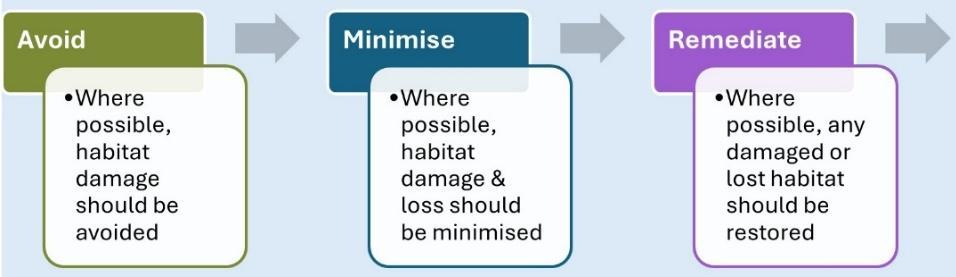
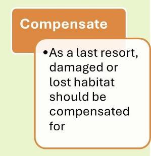

Source: DEFRA Biodiversity Mitigation Hierarchy
6.27. Developments eligible for Biodiversity Net Gain (BNG) are expected to deliver net gain in accordance with the Environment Act 2021. BNG is calculated using the statutory biodiversity metric, which assesses habitats based on size, distinctiveness, condition, and strategic significance. A suitability qualified ecologist establishes the pre-development baseline and the post-development biodiversity value, including any on-site and/or off-site enhancements, which need to exceed this baseline by at least 10%.
6.28. Habitats created or enhanced to deliver BNG are secured and managed for a minimum of 30 years through appropriate legal mechanisms such as Section 106 agreements and Conservation Covenants. A Habitat Management and Monitoring Plan is required from the applicant, and this sets out long-term management, monitoring, and remedial measures. Where BNG is delivered off-site, land is registered on the national register, and monitoring reports are required to be provided to the Authority to ensure compliance over the minimum statutory 30year period.
6.29. The delivery of Biodiversity Net Gain can also benefit the aquatic environment (freshwater, wetlands, estuarine and coastal waters) by improving water quality, water resources, flood protection, and offer other gains through management of rivers and wetlands, including restoring natural processes.
6.30. There are other sources of biodiversity importance that are not attributed value by the Government’s Biodiversity Net Gain metric. An example is swifts, which are an important species within the New Forest, given the number of older buildings in the National Park and the areas suitable for foraging. Utilised by a variety of bird species, universal nest bricks are a significantly better option than external boxes due to their long lifetime, zero maintenance requirements, improved thermal regulation, and aesthetic integration.
6.31. Led by Natural England, a partnership of environmental-interest organisations and the University of Oxford has developed the Environmental Benefits from Nature
(EBN) tool. While its use is not mandatory, the tool has been specifically designed to complement biodiversity net gain approaches to include wider natural capital benefits, such as improved air and water quality, flood risk mitigation, and increased opportunities for recreation. The EBN tool integrates with the Statutory Biodiversity Metric, Green Infrastructure Standards, and the Landscape Character Assessment database, providing a consistent and evidence-based method for evaluating the impacts of land use change across 18 defined ecosystem services.
Conserving and enhancing the landscape
6.32. The diverse landscape of the New Forest, including the ancient woodlands, mature trees and hedgerows, heathlands, unspoilt coastline, farmed landscapes and rural villages, are special qualities integral to the National Park designation.
6.33. National planning policies and primary legislation, including the National Parks & Access to the Countryside Act 1949, are particularly important within the New Forest as they provide the highest status of protection to landscape and scenic beauty for national parks. The conservation of wildlife and cultural heritage are also given great weight when assessing planning applications and sites for new development. The whole of the New Forest National Park is designated as a nationally protected landscape, and therefore all applicants will need to take account of this level of protection in any development proposal. The Authority will seek to ensure that the high-quality, diverse, historic and distinct landscapes and seascapes of the National Park will be conserved and enhanced for future generations.
6.34. Under Section 245 of the Levelling Up & Regeneration Act 2023, all relevant bodies have a statutory duty to seek to further the two National Park purposes in undertaking any functions in relation to, or so as to affect, land in a National Park. This duty applies to national park authorities and to a wide range of other bodies. It is relevant for both development proposals that come forward in national parks through other routes (including national permitted development rights and nationally significant infrastructure projects), and for planning decisions. This strengthened duty reinforces the importance of considering landscape impacts in assessing development proposals. The duty requires relevant bodies to seek to enhance the landscape and habitats of the National Park, and such proposals include the restoration of land to lowland heathland and measures to improve the condition of Sites of Special Scientific Interest, such as wetland restoration. Restoration of landscapes where features have been lost or degraded will be supported by the Authority, where it contributes positively to landscape character. When designing restoration schemes, suitable reference should be made to the historic landscape character, informed by historic characterisation (such as available from Hampshire County Council). Landscape scheme design should also contribute to climate resilience and human health by aiming to incorporate features that provide shade, cooling, flood mitigation, and opportunities for physical activity and mental well-being
6.35. Consideration of the landscape character of local areas throughout the National Park should inform planning applications. The New Forest National Park Landscape Character Assessment 2015 (LCA) provides an evaluation of the different areas and types of landscape character across the Forest. It divides the New Forest landscape into a number of character areas which help to identify key attributes, differing pressures, trends and opportunities. It identifies those landscape features, such as variations in the natural environment, landscape condition, settlement pattern and land uses, that give a locality its ‘sense of place’ and pinpoint what makes it different from neighbouring areas. It also acts as a landscape framework to inform decisions regarding the location and design of development and the capacity of the landscape to absorb potential changes.
6.36. The New Forest’s unique landscape character is, however, under pressure from a number of trends and factors that are likely to affect the National Park over time. The LandscapeAction Plan (LAP) details those issues and pressures and sets out objectives, management guidelines and actions. It offers practical advice and guidance, aimed at both organisations and individuals, to help maintain the special character of the New Forest. Historic England has also published a Farmstead and Landscape Statement39 which helps to identify the historic character of traditional farmsteads and their buildings in the New Forest, and how they relate to their surrounding landscapes.
6.37. An important aspect of national policy is its recognition that planning should acknowledge the ‘intrinsic’ character and beauty of the countryside. Landscape character cannot be solely determined by what is visible from a publicly accessible location, as this can change over time. It is the combination of all the various elements and features of the landscape described in the LCA that make the New Forest National Park’s landscape character special.
6.38. The following policy seeks to ensure that development avoids detrimental impacts on the intrinsic landscape character and its key features. This is in accordance with national planning policy; the National Park’s statutory purposes; and the strengthened legal duty placed on all relevant bodies to seek to further the Park’s purposes in undertaking functions that could affect national parks.
Policy SP14: Landscape character
Great weight in planning decisions will be given to conserving the landscape and scenic beauty of the National Park, and to its wildlife and cultural heritage. Development proposals will be permitted if they conserve and enhance the character of the New Forest’s landscapes and seascapes by demonstrating that:
a) they are informed by the New Forest National Park Landscape Character Assessment, and are compatible with the distinct features and type of landscape in which the development is located;
39 https://historicengland.org.uk/research/current/discover-and-understand/rural-heritage/farmsteadscharacter/
b) the design, layout, massing and scale of proposals conserve and enhance existing landscape and seascape character and do not detract from the natural beauty of the National Park;
c) the character of largely open and undeveloped landscapes between, within, and surrounding settlements will not be eroded or have their setting harmed; and
d) landscape schemes reinforce local landscape or seascape character and help to reveal or better appreciate the significance of the New Forest’s assets. Where planting is appropriate, it is consistent with local character, native species are used and plants are locally or UK grown and sourced, in accordance with the national strategy for biosecurity40
Proposals which are likely to be significant in terms of scale and/or impact will be expected to provide a professionally prepared landscape and visual impact assessment (LVIA) as part of the application submission.
Green & blue infrastructure and open space
6.39. Green and blue infrastructure (GBI) can be defined as a planned and managed network of natural or semi-natural spaces that perform a number of functions. Nature-rich, beautiful places can bring a wide range of benefits to both communities and the natural environment and have a particular role to play in providing recreational opportunities, maintaining a good quality of life for local communities, and encouraging active, healthy lifestyles. Green infrastructure includes such areas as parks and gardens, green corridors, amenity greenspace and allotments, while blue infrastructure includes rivers, streams, ponds, wetlands, and coastal marsh.
6.40. Natural England’s Green Infrastructure Framework41 complements biodiversity net gain by providing standards and tools to support the delivery of high-quality, accessible, multifunctional green and blue infrastructure. GBI helps communities thrive by creating attractive environments, supporting green jobs, and strengthening the local economy. Development should adopt an approach that is both environment and landscape led so as to maximise the beneficial provision of GBI for people and nature recovery. GBI can help in responding to climate change, managing flood risk, protecting and enhancing heritage assets, improving air and water quality, supporting biodiversity, providing for recreation, and enhancing active travel. It is recognised that the typically small scale of development means that significant new greenspace provision is unlikely for most schemes within the National Park area, but green infrastructure should still be considered at an early stage of design as the foundation of the design process.
6.41. Local Nature Recovery Strategies (LNRS) and green and blue infrastructure are closely integrated within spatial planning frameworks. LNRS provide the ecological evidence base that identifies priority locations for habitat restoration
40 https://www.gov.uk/government/publications/uk-biological-security-strategy
41 https://designatedsites.naturalengland.org.uk/GreenInfrastructure/
and nature recovery, while GBI policies set out the spatial mechanisms for delivering these outcomes. LNRS mapping highlights optimal areas for targeting investment to maximise ecological enhancement. This evidence directly informs green and blue infrastructure funding and project delivery, ensuring that interventions – such as tree planting, wetland creation, or natural floodmanagement measures – support locally identified biodiversity priorities and strengthen habitat connectivity. Through this alignment, GBI can deliver multifunctional benefits, including improved climate resilience, better water quality, and enhanced access to nature. The New Forest National Park is covered by two Local Nature Recovery Strategies that act as a connecting layer, linking neighbourhood-scale green spaces with wider regional ecological networks.
6.42. The range of recreation mitigation strategies in place in and around the New Forest highlights the importance of accessible open space and recreational facilities within, and close to, the National Park. These measures help to protect the New Forest’s designated nature sites by reducing recreational pressure, redirecting visitors away from sensitive areas, and providing accessible, alternative greenspaces in more suitable and robust locations.
6.43. Within the National Park, the Authority continues to work with partners and communities to support opportunities to create or enhance green infrastructure. In recent years the Authority has supported a range of open space enhancements, including the provision of new equipment such as children’s play structures at open spaces in several villages, the creation of new wildplay sites and the enhancement of recreational walking routes close to communities. Green and blue infrastructure can provide additional opportunities for local communities to access open space and provides for healthy recreation. Provision or improvement of alternative greenspaces may also be considered along with a range of other measures42 to mitigate the recreational effects of development within the National Park on the internationally important nature conservation designations. Suitable Alternative Natural Greenspaces (SANGs) are usually large greenspaces designed to provide mitigation for recreational pressures from housing development. SANGs are typically part of the strategic mitigation package for larger scale residential development (generally schemes of at least 50 – 100 dwellings where the required SANG meets an indicative minimum size area to meet recreational needs arising from the development) and therefore, are unlikely to be appropriate for the scale of development envisaged in the National Park.
6.44. To deliver its first purpose, the Authority believes that it is important to consider landscapes on a wider scale. The Authority has established the Green Halo Partnership, bringing together public, private and third sector organisations to recognise the economic and social value of the natural environment, support shared objectives for environmental sustainability and economic prosperity, and promote research and awareness about natural capital and its significance. Although rooted in the New Forest, the principles of the Green Halo Partnership extend across Hampshire, the Isle of Wight, Dorset and Wiltshire, informing
42 The Authority will decide what measures are acceptable for a development to comply with the Habitats Regulations – see Policy SP11 and accompanying text.
strategic planning and cross-boundary environmental enhancement. The Partnership identifies natural capital – including geology, soil, water, air quality, biodiversity, and related ecosystem services – as a critical asset to local communities regarding spatial planning, investment, long-term stewardship, guiding decisions about how we manage or develop our area. This will include exploring opportunities for new green and blue infrastructure.
Policy SP15: Green & Blue Infrastructure
Green/blue infrastructure is known to improve mental and physical health by providing areas for recreation, relaxation, and social interaction Proposals which create, maintain, restore, or enhance green and blue infrastructure will be supported, particularly where they:
a) clearly apply a design-led approach to embed multifunctional green and blue infrastructure within development schemes, reflecting local needs and stakeholder input;
b) encourage connectivity between different habitats and designated sites;
c) offer opportunities for local communities to access good quality open space and provide for healthy recreation, community food growing, and active travel;
d) are inclusive, safe, welcoming, well-managed, and accessible for all;
e) relieve recreational pressure on internationally important nature conservation sites;
f) provide scope for the integrated management of the natural and historic environments, while responding to the area’s character;
g) incorporate nature-based solutions to address climate change, strengthen biodiversity, manage flood risk, and enhance air and water quality; and
h) demonstrate the long-term management and maintenance of existing and proposed green and blue infrastructure, with funding secured for a minimum of 30 years following completion of major development.
The Authority will work with partners and adjoining authorities to develop green/blue infrastructure, and to ensure that the impacts of development, both within and beyond the National Park’s boundary, do not adversely affect the landscape character of the Park or of the internationally important nature conservation designations. However, providing new SuitableAlternative Natural Greenspace (SANG) in the nationally protected landscape of the National Park as mitigation for development outside the Park’s boundary is not appropriate, and will only be considered under exceptional circumstances where very significant benefits for the landscape, biodiversity and internationally designated sites of the National Park can be clearly demonstrated.
6.45. The Authority is also working with Natural England and other local authorities within the defined ‘zone of influence’of the New Forest’s internationally designated sites to develop a strategic approach to prevent adverse recreational impacts on
internationally designated nature conservation sites in the New Forest. The overall mitigation package includes new and enhanced greenspace provision in local authority areas outside the New Forest National Park to provide alternative recreational areas close to new developments.
6.46. With the population who live within an easy journey of the New Forest increasing rapidly and planned development immediately surrounding the Park set to rise significantly, an increased number of visitors are likely to come to enjoy the National Park in the coming years. Clearly this will present challenges in how to balance the enjoyment of visitors with the conservation and enhancement of the special qualities of the National Park. Recreation management will be critical, with the New Forest National Park Partnership Plan identifying a range of priority objectives to address these impacts One such objective is to develop a strategic approach to mitigate the potential impacts associated with increasing recreational pressures arising from planned new housing and visitor accommodation on the internationally designated habitats.
6.47. National policy defines open space as any publicly valued open area, including both land and water, that offers opportunities for sport and recreation or serves as visual amenity. It confirms the importance of access to high-quality open spaces and opportunities for sport and recreation, and Policy DP16 supports this approach. Open space can play a vital role in facilitating access to nature, supporting public health, contributing to climate adaptation, safeguarding biodiversity, and mitigating flood risk. The open space requirement of 3.5 hectares of open space per 1,000 population is based on previous development plans for the National Park area. Given that the population of the National Park has been fairly static, this provision standard remains appropriate. The standard comprises 0.2 hectares of designed play spaces for children and young people, 1.25 hectares of formal recreational space, and 2 hectares of informal open space per 1,000 population. Based on the open space requirement as set out above, the Authority requires 35 square metres of public open space to be provided per person. The main villages in the National Park are all deficient in terms of open space provision against this standard.
Policy DP16: Open space
Where there is an identified need, development should either provide for the enhancement of existing open space and amenity areas or provide on-site open space to the minimum provision standard of 3.5 hectares of public open space per 1,000 population. Development proposals will be supported where they demonstrate opportunities to integrate open space within the wider green and blue infrastructure network, deliver measurable environmental net gains, and enhance public access to – and engagement with – nature.
Proposals that result in the loss of existing open space, sports and recreational buildings and land, including playing fields, will not be permitted unless:
a) an assessment has been undertaken which has clearly shown the open space, buildings or land to be surplus to requirements; or
b) the loss resulting from the proposed development would be replaced by equivalent or better provision in terms of quantity and quality in a suitable location; or
c) the development is for alternative sports and recreational provision, the benefits of which clearly outweigh the loss of the current or former use; or
d) the Education Authority has received approval for the disposal of surplus school playing fields from the Secretary of State, in accordance with Section 77 of the Schools Standards and Framework Act 199843, and where equivalent or greater community benefits are provided
6.48. New housing development should incorporate accessible open amenity areas and features, preferably within its site boundary to enhance the quality of the environment for the benefit of residents, biodiversity and the surrounding area The requirement to provide public open space is separate to, and in addition to, the provision of alternative greenspace for mitigation against impacts on the internationally designated nature conservation sites.
Recreational horse riding and horse keeping
6.49. Horse riding and horse keeping have a long history in the New Forest and are part of its cultural identity. In the region of 3,500 horses are kept within, and immediately surrounding, the National Park. Together with horses kept by farmers and Commoners, the equine community makes a valuable contribution to the local economy.
6.50. When it is done well, horse keeping can make a positive contribution to the management of the New Forest and assist farmers and Commoners seeking to diversify their activities. But in the few cases where it is done badly, there can be problems associated with overgrazed fields, poor fencing and inappropriate lighting, all of which can lead to a negative impression of horse keeping. There are examples of both within the New Forest.
43 https://www.legislation.gov.uk/ukpga/1998/31/section/77
6.51. Planning permission is usually required for most horse-related development. However, under the General Permitted Development Order 2015, there may be some scope to provide buildings or enclosures associated with the keeping of recreational horses in the garden of a domestic dwelling, incidental to the enjoyment of the dwelling house. It is advisable to seek the advice on the need for planning permission for such buildings from the Authority.
Policy DP17: Recreational horse keeping
Permission will be granted for recreational horse keeping provided that the proposal does not:
a) have an adverse impact on the landscape, aquatic environment, or any nature conservation interests;
b) harmfully increase riding pressures on the Open Forest; or
c) result in the loss of back-up grazing land.
6.52. The Authority cannot control the use of land for grazing. However, the keeping of recreational horses involves a more intensive use of land which is subject to planning control. The distinction between grazing and keeping is not always clear, although a judgement can normally be made on the basis of the area of grazing land available per animal. As a guideline, the keeping of horses is generally understood to be where less than 0.5 hectares of land is available per horse44 Other key indicators can include the existence of stables, other facilities, and the condition of the land.
6.53. Planning applications should be accompanied by sufficient information to demonstrate that the associated impacts of any new recreational horse keeping use is positive rather than negative, for example by including details of fencing and landscaping.
6.54. The high demand for land for horse keeping can reduce the amount of back-up grazing available for Commoners, resulting in a need to maintain an adequate supply of back-up grazing land. Updated evidence highlights the pressures on back-up grazing in and around the New Forest45
6.55. Policy DP17 also seeks to ensure that horse keeping does not impinge on the New Forest by adding to riding activity in the area and/or contributing to the erosion of the Open Forest.
44 Defra Code of Practice for the welfare of horses, ponies, donkeys and their hybrids (April 2013) reports that as a general rule, a horse will require a minimum of 0.5 hectares (1.25 acres) of good grazing if no supplementary feeding is being provided
45 Commoners’ back-up grazing in the New Forest: extent and distribution, New Forest Association (2025) newforestassociation.org/wp-content/uploads/2025/06/Final_back-up_land_report.pdf
Policy DP18: Field shelters and stables
Permission will be granted for field shelters provided that the building is:
a) sensitively sited to be unobtrusive in the landscape;
b) simple in appearance and modest in scale; and c) constructed of appropriate materials.
The same considerations apply to stables although these should be located close to existing buildings where these exist.
6.56. The Authority seeks to limit the proliferation of buildings within the New Forest, primarily because of their impact on the landscape. However, the need for field shelters (which are commonly characterised by one side of the structure left open) is recognised and therefore they will normally be permitted, providing they are sensitively designed and can be accommodated without being obtrusive in the landscape. The same considerations apply to stables, although these should be located close to existing buildings.
Policy DP19: Maneges
The development of outdoor maneges will be permitted provided that:
a) they do not result in any detrimental impact on the landscape and ecology of the New Forest; and b) they do not involve the installation of lighting
The development of indoor maneges will not be permitted other than in accordance with Policy DP58 (Reuse of farm buildings) The standard manege measures 20 metres by 40 metres and special justification will be required for larger structures within the nationally protected landscape of the National Park.
6.57. Maneges are all-weather riding arenas used for the schooling of animals and the training of riders. While the Authority recognises that the availability of maneges may reduce the use of the Open Forest, particularly by riding schools, there are concerns about the physical impact of their development on the New Forest landscape and ecology. The Authority wishes to minimise the environmental impact of these proposals and considers that this form of development is likely to be acceptable only where it is contained within, or closely related to, an existing group of buildings and makes use of materials that blend in well with the New Forest’s landscape.
Coastal erosion and development
6.58. The New Forest National Park includes 26 miles of coastline along the Solent and Southampton Water. It will be necessary to ensure that the main settlements are given protection through carefully designed defences which do not adversely affect the sites of European nature conservation importance or create
additional flooding issues for other parts of the coast. In addition to coastal protection works, other small-scale coastal development might include coastal access works, upgrading existing coastal car parks, replacing beach huts and existing mooring facilities. The aim of this approach is to maintain the character of the undeveloped coast, protecting and enhancing its distinctive landscape.
Policy SP20: Coastal development
Small-scale proposals for development on the coast will be permitted provided that they:
a) will not have adverse impacts on coastal processes or existing flood defences;
b) are in keeping with the character of the coast;
c) will not cause an unacceptable and/or unjustified level of harm to landscape or heritage interests, and will have regard to the importance of seaward and landward views;
d) protect or enhance coastal habitats and species, including all designated nature conservation sites; and
e) will not lead to the consolidation of scattered development.
6.59. Policy SP20 seeks to protect the undeveloped nature of the National Park coastline. The policy ensures a level of protection consistent with the Government’s Marine Policy Statement (MPS) and the South Marine Plan. The South Marine Plan helps integrate marine and land planning, contributing to vibrant coastal communities and consideration of cultural and built heritage, seascape and local environmental quality. TheAuthority will work with the marine planning authority to ensure that the seascape quality of the New Forest coastline is maintained and enhanced.
6.60. The England Coast Path (ECP) is a new national trail being created by Natural England through the Marine and Coastal Access Act 2009 and extends along the coast of the New Forest. It allows people to gain access to the coastline and provide opportunities to enjoy one of the special areas of the National Park. Any small-scale proposals associated with the coast path will be considered against Policy SP20 on coastal development
6.61. National policy states that strategic planning policies should set out an overall strategy for measures to address climate change and adaptation. Local Plans are required to reduce risk from coastal change by avoiding inappropriate development in vulnerable areas and not exacerbating the impacts of physical changes to the coast. Planning authorities should identify as a Coastal Change Management Area any area likely to be affected by physical changes to the coast and be clear as to what development will be appropriate in such areas and in what circumstances. Coastal Change Management Areas may be defined where rates of shoreline change are expected to be significant over the next 100 years They will not normally need to be defined where the accepted shoreline management
plan policy is to hold or advance the line (maintaining existing, or building new, flood and coastal erosion risk management infrastructure) for the whole period covered by the shoreline management plan.
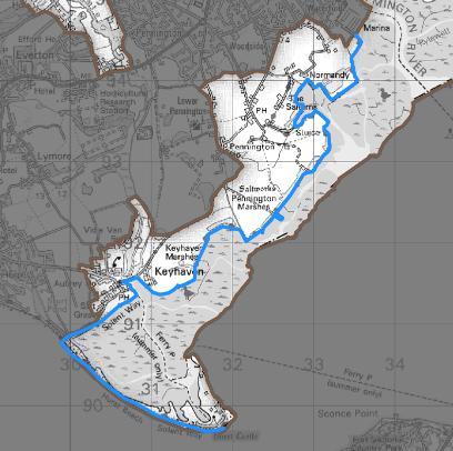
6.62. The North Solent Shoreline Management Plan covers the whole of the New Forest National Park’s coastline and is a high-level, non-statutory policy document setting out a framework for future management of the coastline and coastal defences. The Plan was published in 2010 and for the majority of the National Park’s coastline the policy is ‘hold the line’. Since the Plan was published, the coastline of the National Park has continued to experience change. The Environment Agency’s ‘Hurst Spit to Lymington Strategy’ is exploring a long-term (100 year) sustainable future for the coast between Hurst Spit and Lymington, to respond to climate change and sea level rise. The designation of a Coastal Change Management Area for the stretch of the Park’s coastline between Hurst Spit and Lymington will assist in managing coastal change over the plan-period in an area rich in natural, historic, and built environment designations, and which makes a significant contribution to the economy of the area; for example, Hurst Castle. There is an existing Coastal Change Management Area designated for the coastline to the west between Barton-on-Sea and Highcliffe in the adopted development plan for New Forest District.
Policy SP21: Coastal Change Management Area
A coastal change management area (CCMA) is defined along the National Park’s southern coast between Hurst Spit and Lymington (as illustrated on the Policies Map and the inset map below). Within this CCMA the following criteria will apply:
a) new residential development will generally not be appropriate (subject to the exceptions listed below);
b) residential extensions to existing dwellings will be permitted in accordance with the other policies in the Local Plan;
c) replacement dwellings will be permitted in accordance with the other policies in the Local Plan;
d) essential infrastructure will be supported – including the potential rerouting of the England Coast Path;
e) temporary uses such as car parks and camping uses may be permitted, subject to time-limited planning permissions; and
f) development proposals that deliver community benefits and/or create or enhance habitats will be supported.
Coastal Change Management Area
Pollution
6.63. Lying between the large urban areas of Southampton, the industrial areas along Southampton Water and the South East Dorset conurbation, the National Park is vulnerable to pollutants from industry, vehicles and many other sources which can harm human and other species’ health, together with general noise and light pollution associated with urban areas.
6.64. The impacts on air quality arising from the increased traffic generated by development continue to be monitored to determine whether it would raise pollution levels that could affect the integrity of the internationally designated nature conservation sites in the New Forest. To date impacts have not been identified and monitoring work will continue under this Local Plan for the National Park area. If monitoring at any time shows that the change is likely to have a significant effect on the designated sites, theAuthority will support other authorities in devising an appropriate strategic mitigation strategy.
Tranquillity in the New Forest
6.65. National planning policy recognises the importance of protecting areas of tranquillity. Tranquillity is identified as a special quality of the New Forest National Park, reflecting its relative peace and naturalness, extensive unfenced landscapes, and sense of space, remoteness and freedom. These characteristics provide a marked contrast to the increasingly urbanised and intensively managed landscapes of southern England and contribute significantly to the Park’s role in supporting health, well-being, and enjoyment of the natural environment.
6.66. Tranquillity can be adversely affected by intrusive visual and auditory influences, particularly those arising from man-made features such as artificial lighting, transport infrastructure, noise generated from machine equipment, overhead power lines, and inappropriate development (either by virtue of its design, scale or location) Noise and other forms of disturbance may have significant harmful effects on amenity, wildlife behaviour, and the perception of remoteness that underpins the National Park’s special character. Even small-scale development can result in disproportionate impacts in areas where existing background levels are low.
6.67. To safeguard this special quality for current and future generations, development proposals are required to demonstrate that they would not result in unacceptable impacts on tranquillity. To support this approach, the Authority has developed a map highlighting the most tranquil areas of the New Forest46 based on levels of man-made noise and visual disturbance Areas within the north and south-east of the Forest were identified as experiencing the highest levels of tranquillity.
6.68. The potential impacts of noise and light pollution will be appropriately managed in accordance with Policies SP22 and SP23. Visual intrusion and landscape character will be protected through the application of Policies DP2 and SP14. The Authority will also seek to secure International Dark Sky Reserve status through the International Dark Sky Association.
Policy SP22: Tranquillity
Development proposals must protect and, where possible, enhance the special qualities of the National Park.
Proposals for all forms of development should have regard to the latest version of the New Forest National Park Design Code, particularly in relation to windows, dormers, rooflights, and the design and placement of external lighting, to minimise light spill from both external and internal sources.
Development proposals will only be permitted where it is demonstrated that they would not result in unacceptable noise, visually intrusive structures or other disturbances that would adversely affect tranquillity.
46 www.newforestnpa.gov.uk/planning/landscape-policy-documents/
In assessing proposals, particular regard will be given to whether:
a) noise-sensitive receptors, including areas designated for nature conservation, and existing or approved residential development, would experience significant adverse effects;
b) the proposal is compatible with the character of the surrounding area, particularly where baseline ambient noise levels are low; and
c) the proposal would not encroach on areas identified as having high tranquillity value through tranquillity mapping47 or other relevant evidence.
Development proposals that seek to remove visually intrusive man-made structures from the landscape will be supported.
Dark skies
6.69. The New Forest National Park contains some of the darkest night skies in England, which is integral to the Park’s landscape character, biodiversity, and recreational enjoyment. Artificial lighting represents one of the principal threats to the dark skies of the National Park.
6.70. Excessive, poorly designed or unnecessary lighting can result in sky glow, glare, and light spill, leading to habitat fragmentation and adverse effects on bats, birds, nocturnal invertebrates, and other light-sensitive species. In addition, inappropriate lighting can harm visual amenity, the setting of heritage assets, and the wider experience of darkness.
6.71. Where external lighting is required, it should be energy-efficient and, where feasible, powered by on-site renewable energy sources. To ensure that lighting operates only when required, it should be controlled through curfews, sensors, timers, or adaptive technology and dimmed or switched off during periods of low activity.
6.72. While many minor forms of domestic lighting do not require planning permission, external lighting that does require consent – either in its own right or as part of a wider development – constitutes a material planning consideration.
Policy SP23: Dark skies
To protect the National Park’s dark skies, development proposals must follow an avoidance-first approach to external lighting. External lighting will only be permitted where it is clearly demonstrated to be strictly necessary for an identified purpose, such as working, wayfinding, safety or security.
Development proposals must demonstrate that opportunities to reduce light pollution have been taken through the avoidance of lighting where appropriate; and that, where external lighting or light spill from internal lighting cannot be
47 New Forest National Park Tranquil Areas Mapping 2015: https://www.newforestnpa.gov.uk/document/tranquillity-map-of-new-forest-national-park/
19
avoided, then adverse impacts are mitigated to the greatest reasonable extent through measures including down-lighting and avoiding bright-white lights.
Proposals involving external lighting will be permitted only where lighting does not cause harm to:
• the dark skies quality of the National Park;
• ecological networks and light-sensitive or nocturnal species;
• landscape character, heritage assets, or visual amenity; and
• neighbouring properties, open countryside, woodland edges, watercourses, or areas designated for nature conservation.
Proposals for major development, and for development within particularly sensitive locations, must be supported by a Lighting Impact Assessment.