5.2 Connectivity and Movement 5.0 Masterplan Framework
A well-connected, safe and sustainable town centre is central to Basildon’s regeneration. Improved connectivity will support economic vitality, encourage active travel, reduce traffic and air pollution, and unlock land for more productive uses. Movement infrastructure also helps shape the town centre's identity, supporting inclusive public spaces and sociable behaviour.
Strategic Approach to Movement
The regeneration strategy aims to transform Basildon Town Centre into a multimodal transport hub, building on strong rail links to London while addressing local and borough-wide accessibility. By diversifying land uses, integrating transport networks, and improving the public realm, the town centre will become easier to navigate.
Movement infrastructure must support a safe, inclusive and vibrant town centre, contributing to its character, sustainability and long-term resilience. This strategy is underpinned by the Basildon Local Cycling and Walking Infrastructure Plan (LCWIP) and the Basildon Town Centre Safety Plan (2025), which provide a framework for active travel and safety improvements across the town centre.
Improving Station Connectivity
Basildon's train and bus stations are close together but poorly connected. Southernhay creates a barrier through vehicle-dominated infrastructure and fragmented public realm. The regeneration strategy prioritises pedestrian and cycle access, visual connectivity and placemaking to create a cohesive transport interchange.
Interventions include increasing the bus station's visual prominence from the train station, upgrading the public realm between the stations and along key routes into the centre, and providing secure
cycle storage. Further detail is provided in Section 6.8.
Overcoming the Ring Road Barrier
The ring road creates physical and psychological barriers between neighbourhoods and the town centre and prevents those who live nearby from choosing active travel. Proposed changes include downgrading the road to prioritise walking, wheeling (e.g. use of mobility aids) and cycling, adding level crossings, and improving underpasses and lighting to support safe and attractive movement. These measures will be coordinated with Essex County Council and align with the LCWIP.
Enhancing Internal Connectivity
Internal movement between character areas also needs improvement. The Safety Plan identifies key connectors spanning Town Square, East Walk, Market Square, and approaches to Eastgate and Westgate, which will be elaborated in Chapter 6.0 Character Areas.
Embedding Safety in Movement Infrastructure
Safety should be integrated into the design of routes and public spaces. The Safety Plan recommends improving natural surveillance, reducing blind corners, and activating routes through programmed events. These measures also support placemaking and vibrancy.
CCTV coverage and warden presence should be considered along priority routes, particularly in areas with high footfall such as public transport stations and events venues. Spaces designed for large gatherings should consider the implications of the Terrorism (Protection of Premises) Act (Martyn’s Law), including appropriate counter-terrorism measures.
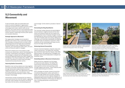
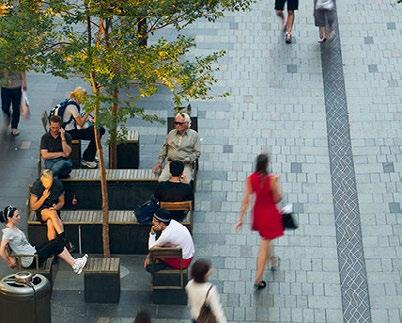
Lonsdale Street Redevelopment, Melbourne (BKK Architects) creates spaces for people along highways, offering pleasant routes and resting spots. Photo: John Gollings
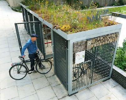
Green Roofed Cycle Shelters. Secure, enclosed bicycle shelters with key-operated doors, where cyclists can use their own bike locks once inside. Photo: Green Roof Shelters
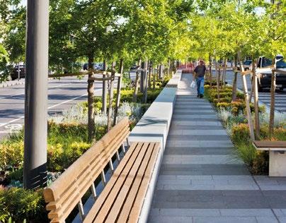
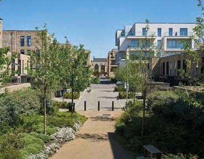
Pitt Street Mall, Sydney (Tony Caro Architecture) is a central pedestrian precinct featuring high-quality paving, seating, and planting areas. Photo: Brett Boardman Aura, Great Kneighton (BBUK) uses changes in materials, planting, and levels to distinguish transport modes without excessive signage and bollards. Filtered permeability encourages active transport. Photo: Tim Crocker & Tim Soar
`
Policy TC2: Connectivity and Movement
To promote active travel, walking and cycling should be the most attractive and accessible options. Development proposals must align with the Healthy Streets framework and contribute to walkable, wheeling-friendly and cycle-friendly neighbourhoods.
New developments impacting the public realm must adhere to the following criteria, where applicable and relevant to their location:
a. Deliver high-quality, inclusive movement routes that reduce obstacles and enhance connectivity, aligned with the Basildon LCWIP and Safety Plan.
b. Prioritise pedestrian movement through attractive street design, active ground-floor frontages, and the inclusion of pedestrian crossings.
c. Provide continuous, legible cycle routes in line with the LCWIP and Local Transport Note (LTN) 1/20: Cycle Infrastructure Design, minimising dismounting.
d. Provide cycle parking that accommodates a range of cycles, including trikes and cargo bikes, and is located at strategic points where LCWIP routes meet the Cycle Exclusion Zone. These locations should be supported by benches, passive surveillance (e.g. cafés with outdoor seating), and charging points for electric cycles.
e. Design active travel routes to be accessible at all hours, with shelter, rest points, and opportunities for social interaction and community use.
f. Implement traffic-calming measures to reduce speed and traffic flow, improving safety and comfort for pedestrians and cyclists, while considering emergency service access and response times. The success of this initiative will depend on securing the necessary support and approval from the Highway Authority.
g. Ensure service yards and vehicular access do not create inactive or obstructive spaces and support safe pedestrian and cycle movement.
h. Movement of Heavy Goods Vehicles and Light Goods Vehicles must be carefully managed to support economic activity and ensure efficient delivery of goods and services. Their routes and access points must be well integrated into the public realm and designed to minimise conflict with pedestrian and cycle movement.
i. Support an integrated public transport network linking bus, train, taxi and cycle modes.
j. Support improvements to public transport that encourage uptake, including enhanced regularity, affordability, and quality of bus services, alongside better waiting environments and real-time service information.
k. Adopt a car-lite approach, including blue badge parking, car club provision, and sustainable transport planning.
l. Submit Transport Assessments and Travel Plans in line with Highway Authority guidance.
m. Incorporate inclusive design principles to ensure accessibility for all ages and abilities.
n. Include wayfinding and signage that supports intuitive navigation without relying on reading and enhances town centre legibility.
o. Ensure that movement infrastructure is designed for long-term durability and ease of maintenance, with clear responsibilities for ongoing management.