22 minute read
Hiking tHe Canyon Country of utaH and Colorado

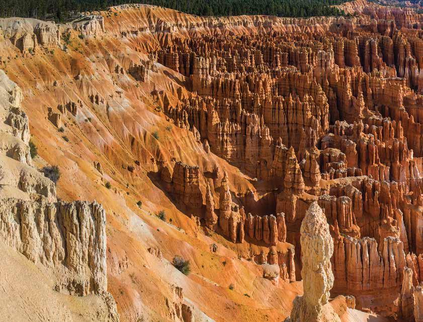
The impressive and colorful Bryce Canyon. Photo by Rod Martinez
hen you hear the word “canyon” you probably think of the Grand Canyon. The Grand Canyon is 277 river miles long, 18 miles wide, and up to 5,280 feet deep; it has earned its name. Zion and Bryce Canyons are two other very impressive and photogenic canyons located relatively close to our Colorado home. Although not as well known, Colorado and southeast Utah have an abundance of other canyons to explore, hike, and photograph.
Western Colorado
On the outskirts of Grand Junction you should take the time and effort to hike the canyons of the Colorado National Monument. The Monument Canyon and Ute Canyon Trails, as described in The Best Grand Junction Hikes pack guide published by CMC Press, will take you into the heart of the Colorado National Monument. The trails descend 1,440 and 1,640 feet, respectively, to the lower trailheads at the base of the canyon. Along the trails you will pass by large red rock spires that make for interesting views.
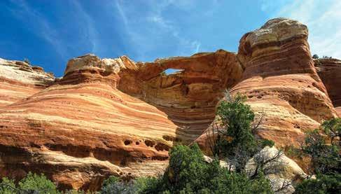
Located to the southwest of the Colorado National Monument is McInnis Canyons, a national conservation area. The purpose of a national conservation area is to preserve, protect, and restore some of America’s most spectacular landscapes. The Black Ridge Canyons Wilderness Area, which is 75,580 acres of the 122,300 total acreage of the McInnis National Conservation Area, has trails into Mees, Knowles, and Jones Canyons. The trails into Devil’s, Flume, and Rattlesnake Canyons are also described in the The Best Grand Junction Hikes pack guide. Rattlesnake Canyon is truly incredible and very photogenic. The hike is a difficult to strenuous 14.2-mile walk with an elevation gain of 2,500 feet. There are nine natural arches in Rattlesnake Canyon, the largest concentration of arches in North America outside of Arches National Park.
Black Canyon and Dominquez Canyon—also described in The Best Grand Junction Hikes pack guide—are hikes that will take you into two distinct Colorado canyons. Dominquez Canyon, located about 17 miles south of Grand Junction, is a 66,280-acre wilderness area located in the heart of the 210,012-acre DominquezEscalante National Conservation Area. The Dominquez Canyon Trail is 9.0 miles round-trip with minimal elevation gain. The scenery is spectacular as the trail follows the ever-flowing Little Dominquez Creek. Keep a lookout for desert bighorn sheep—you may spot them grazing at the base of the sandstone cliffs. The scenery and potential of seeing bighorn sheep are topped by the numerous rock art sites along the canyon walls and large boulders along the trail. The first petroglyphs are seen on a large rock about 3.4 miles into
By Rod Martinez

the hike. A greater concentration of petroglyphs is found on other rocks fifty yards further down the trail. Only history knows if this was a permanent tribal location or an area used only parts of the year by the Ancient Ones.
The Black Canyon of the Gunnison is the only canyon in North America that combines a narrow opening, sheer walls, and startling depths to give its visitors a unique and awesome canyon landscape. The Black Canyon of the Gunnison National Park protects 14 miles of the gorge carved by the Gunnison River. The swift and turbulent Gunnison River continues to carve its way through the sheer walls of dark gray stone some 2,700 feet below the cliff edge. In places, the canyon is deeper than it is wide. Because it is so narrow the sunlight penetrates to the bottom of the canyon only at midday. When sunlight allows you to view the full depth of the canyon, you can see how an “artist” has painted the canyon walls in different colors with light and dark colored rock.
Within the boundaries of the Black Canyon of the Gunnison National Park there are no maintained or marked trails into the inner gorge. A ranger told me that the routes into the gorge are difficult to follow, extremely steep, and hazardous because of the loose rock. The ranger also advised that hikers be in excellent shape, able to find their own route, and prepared for self-rescue.
Although it is strongly not recommended to hike to the bottom of the Black Canyon in the national park, you can do so in the Gunnison Gorge National Recreation Area. The four trails to the Gunnison River rank from moderately difficult to difficult: • Bobcat Trail: Difficult, 3.0 miles round-trip, 800 feet elevation change, and undeveloped. The trail is hard to follow and has a steep descent down a rock face for the last 0.5 miles. • Chukar Trail: Moderate to difficult, 2.2 miles round-trip with a 560-foot elevation change. • Duncan Trail: Difficult, 3.0 miles round-trip, 840-foot elevation change, and the last half mile is steep with loose scree. • Ute Trail: Moderately difficult, 9.0 miles round-trip, 1,200-foot elevation change, a well-developed trail with a gradual slope.
There are numerous trails on the South Rim of the Black Canyon in the national park. These trails range from the easy 2.0-mile round-trip Uplands Trail to the 2.0-mile round-trip strenuous Oak Flat Loop Trail. The Rim Rock, Warner Point, and Oak Flat Loop Trails will give you tremendous views of the Black Canyon.
The North Rim of the Black Canyon is an additional three to four hour drive from the South Rim. The North Rim is sparsely visited, and the road access is dirt, but the North Rim offers equally beautiful views. Trails on the North Rim range from the easy 0.3-mile Chasm View Nature Trail to the 3.0-mile round-trip North Vista Trail.
Dinosaur National Monument
Dinosaur National Monument, in northwest Colorado on the Utah state line, is well known for its paleontology site at the Utah visitor center north of Jensen, Utah. The quarry has around 1,500 dinosaur bones exposed on a cliff wall for the general public to view from a safe distance. The bones are the main draw, but equally impressive is the 210,000 acres of rugged, beautiful, and colorful country. Around 95 percent of the monument is currently managed as a wilderness study area.
Two great rivers, the Green and Yampa, converge and wind their way around Steamboat Rock at Echo Park. My friends Bill and Martha Mitchem, 60-year residents of Rangely, Colorado, affectionately refer to this area as the “Center of the Universe.” To get there from the Canyon Visitor Center in Colorado, drive 25 miles north and take a right on the Echo Park Road. The dirt road drops 1,000 feet in 8 miles to Echo Park. Please note this road is impassable if wet. Once in the bottom of the canyon, where the rivers converge, hike along the waters edge and admire the 1,000-foot Steamboat Rock. Steamboat Rock is a sandstone island between the green colored Green River and the brown waters of the Yampa River.
The Harpers Corner Road continues past the Echo Park Road for another 7.0 miles where the road ends at Harpers Corner. Be sure to stop and enjoy the views of the canyons from the Island Park and Echo Park viewpoints. Notice how dominant but small Steamboat Rock looks from this distance. Harpers Corner Trail is a moderate 3.0-mile round-trip hike with minimal elevation gain. The overlook at the end of the trail provides sweeping views of the canyons of the Green River 2,500 feet below. Other trails in the monument are relatively short and easy to hike. The views of the canyons and different geology will make the time spent worthwhile.
To get different and more extensive views of the canyons and rivers, consider driving the Yampa Bench Road. The Gates of Lodore Road, 10 miles of dirt road from Hwy 318, ends at The Gates of Lodore. This is where it appears that the Green River is swallowed by a pair of cliffs that seem to rise out of nowhere, as if they were gates. The 18-mile-long gravel Island Park Road will give access to many petroglyph panels and more great views of the Green River. Eleven miles from the beginning of the Island Park Road is one of the most outstanding Fremont petroglyph panels in the area. If you have the time, another fascinating and adventurous way to explore the canyons of the Green and Yampa Rivers is to take a rafting trip.
Southeast Utah
If rock art, petroglyphs, and pictographs are your interest, then Nine Mile Canyon is a must-see area. The canyon is located eight miles east of Price, Utah on Highway 6/191, where you will turn north on 2200 East (Soldier Creek Road, at the Walkers Food and Fuel Chevron Station). The canyon is 40 miles long, not nine miles, as it is named. Nine Mile Canyon is promoted as “North America’s longest art gallery.” There are an estimated 1,000 rock art sites with a combined single image count of over 10,000. There is little question for the archeologist that this is the largest concentration of petroglyphs and pictographs in North America. Research has also identified hundreds of pit-houses, rock shelters, and granaries.
In 2009, 63 sites in the canyon were added to the National Register of Historic Places, with another 164 added in 2012. The Bureau of Land Management has announced plans to nominate some 600 more in years to come. The biggest danger to the sites is the dust caused by heavy truck traffic, which clings to the rock art sites. In 2004 Nine Mile Canyon was added to the National Trust for Historic Preservation’s list of America’s Most Endangered Places. This is a marvelous area to visit for ancient history. Hiking opportunities are minimal, but photographic opportunities are optimal.
The hiking opportunities in Utah’s southeast quadrant are endless. This part of Utah, with the closest access to Colorado, has two national parks, two national monuments, and two wilderness areas. All of these areas have trails that range in difficulty from easy to strenuous and are 0.5 miles to over 20 miles long.
In the soon to be published The Best Moab and Arches National Park Hikes pack guide, I describe numerous hikes into canyons in the Moab area. Mill Creek Canyon Trail is a fun and refreshing hike along and through Mill Creek on the southeast outskirts of Moab. Hunter Canyon, slightly west of Moab, will take you by another stream where you can view a large arch on the west canyon rim. Negro Bill Canyon, approximately 3.0 miles east and north of Moab, has a terrific trail that follows a stream to the world’s sixth largest natural bridge, Morning Glory Natural Bridge.
Another hike described in The Best Moab and Arches National Park Hikes is Horseshoe Canyon. This trail, located about 40 miles south of Green River, Utah, is 6.5 miles round-trip and drops 780 feet into Horseshoe Canyon. The canyon has tall sandstone walls and an abundance of wildflowers in early spring. Horseshoe Canyon is home to some of the most significant rock art in North America, including “The Great Gallery.”
Canyonlands National Park is 337,598 acres of immense, long, deep, and very colorful canyons. The park preserves arches, buttes, spires, and mesas, as well as the canyons of the high desert of southeast Utah. When you study a map of Canyonlands it appears that the park is one large area, but it is actually divided into four districts by the Colorado and Green Rivers. (The rivers constitute a separate district.)
The Maze District offers some of the most distinct and remote areas in the nation with names that catch your attention: The Doll House, Ernie’s Country, The Land of The Standing Rocks, the Fins, and Chocolate Drops. The area is very remote and access is only for the hardiest of hikers and most experienced four-wheel-drive vehicle aficionados. The only designated trail in the Maze District is the trail leading to the Maze Overlook and the South Fork Horse Canyon and it is hardly a trail at all. This trail requires you to be an experienced hiker with the ability to lift and lower packs on very exposed and steep sections of slickrock.
In my newest CMC Press pack guide, The Best Canyonlands National Park Hikes, to be published in the fall of 2015, I will take you on twenty different hikes into the third and fourth districts, the Needles District and Island in the Sky District. These hikes range from the easy Mesa Arch Trail and Grand View Overlook Trail to the more difficult 6.0-mile round-trip Goose-

berry Trail. The elevation loss and gain is about 1,300 feet in 3.0 miles over a total hike of 6.0 miles. In all cases you will have outstanding views of the deep canyons carved by the Colorado and Green Rivers.
The Needles District is the “hiker” district. It has over 55 miles of trails, many of them established loop trails, which will give you different views into and out of the hiking areas. The hikes in the pack guide range from the moderately easy 2.4-mile Slickrock Foot Trail to the 11.0-mile round-trip difficult Confluence Overlook Trail. Here you are given a tremendous view of the spot where the Green and Colorado Rivers join together. One of my favorite—but more difficult hikes—is to Druid Arch. The 5.5-mile one-way hike ends at a canyon where the 100-foot high Druid Arch stands tall at the head of Elephant Canyon.
Canyonlands is 337,570 acres and 100 square miles of fins, mesas, buttes, and serpentine canyons. Each year nearly 500,000 visitors enter Canyonlands—which makes this the least visited National Park in Utah—but a lot fewer than 500,000 people hike the trails to really experience the canyons of Canyonlands.
Take a hike and get out and enjoy the canyons of Colorado and southeast Utah! △
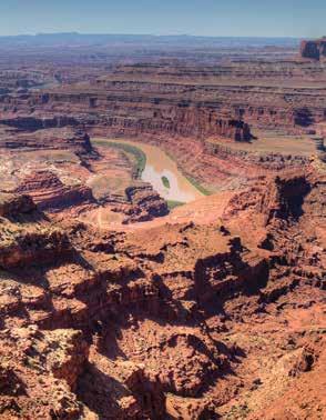

Top Left: Steamboat Rock at “The Center of the Universe,” Dinosaur National Monument. Top Right: Across the Colorado River is Island in the Sky District of Canyonlands National Park as seen from Dead Horse Point State Park near Moab, Utah. Bottom Left: Eye Arch, one of nine arches in Rattlesnake Canyon. Bottom Right: The Green River flows to Utah from Dinosaur National Monument. Photos by Rod Martinez.
The Best Front Range Trail Runs:
Running Year-round in Colorado’s Front Range
By Peter N. Jones
The upper canyon as seen from the Rimrock Trail. Photo by Peter N. Jones

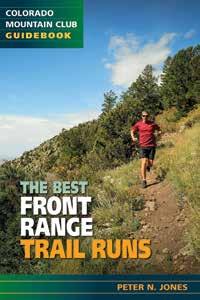
t all started about a year and half ago, when my dad, a CMC past president, forwarded me an email from thenCMC Press editor Christian Green, who was looking for people to help with a new book on trail running along Colorado’s Front Range. Having been a long-time trail runner and growing up in Boulder, I contacted Christian and offered my services. After some communications and discussions, I was given the lead on the project and eagerly set about running, writing, and photographing what I believed were some of the best trails for running along the Front Range. Fast forward to today, and I am thrilled to finally see this project come to fruition with the publication of The Best Front Range Trail Runs, scheduled to hit bookstores in mid-December.
Although I had grown up running and hiking most of the trails between Fort Collins and Colorado Springs, running with the purpose of writing about the trails brought new insights and discoveries. From running the smooth and stunningly beautiful Blue Sky and Indian Summer Trails outside of Fort Collins on a crystal clear winter day, to the familiar but always exhilarating Bear Peak West Ridge Trail near Boulder, running these trails with a mind to writing about them brought new appreciation. Likewise, carrying a camera for on-trail photographs helped me see new features and aspects of the trails and surrounding environments, such as the splendid fall colors of the aspens found on the upper section of Apex Trail outside of Golden, or the cool clouds and mist of a long run up the Barr Trail and Pikes Peak near Colorado Springs.
Not only does The Best Front Range Trail Runs include fifty trails—along with mileage, elevation gain, trail descriptions, maps, and color photographs—but it also includes short anecdotes, quotes, and contributions from many local runners. These add flavor and variety to the guide, and give an insider’s view into why others consider the trails along the Front Range to be some of the best in the country for running.
The trails included in the book range from flat and fast trails found along the eastern edge of the Front Range, where smooth dirt paths wind through tallgrass and prairie environments, to steep and semi-technical trails that climb sharply up along the varied and topographically interesting hills of the Front Range. In all, the book includes something for everyone— from runners who are just becoming interested in taking their training onto the trails to those who have been running trails for many years, but who are seeking out some new experiences and places to run that are within a short distance of home.
I’m honored to have been able to bring this project to fruition. Working with CMC Press on this project has been a delight—not only has it opened up many new adventures and trail runs for me, but I am confident that it will prove to be a valuable book for others who are seeking to run and explore the many beautiful trails we are blessed with along Colorado’s Front Range. Here is an excerpt from the book—two of my favorites, which can often be run in winter. Enjoy! △

Near the overlook area on the Talon Trail at Cheyenne Mountain State Park. Photo by Peter N. Jones One of the many excellent views along the Talon loop. Photo by Peter N. Jones
Castlewood Canyon Loop (Denver Area)
Round-Trip Time 1 hour–1½ hours
Round-Trip Distance 6.9 miles
Start and End Elevation 6,300 feet (Homestead Trailhead) Total Elevation Gain 828 feet
Effort Level Easy to moderate
Possible Workout Type Tempo run, fartleks, speed work, recovery run
Best Time to Run All year; summer can be hot and snow may be present in winter
Support or Water Points None
Runability
Type of Run
Parking
Nearest Landmark 100%
Loop
$7 day pass
City of Castle Rock
Rules and Regulations Dogs must be leashed at all times
More Information Visit the State Parks website: http://www.parks.state.co.us/Parks/ CastlewoodCanyon/
Comment: This loop run takes runners through the majority of Castlewood Canyon State Park, providing views down into the canyon formed by Cherry Creek. It also traverses the canyon rim through a variety of environments and ecosystems.
Getting There: This run begins and ends near the Lucas Homestead Historic Site, located just inside the Westside entrance to the park. To reach the Westside entrance of Castlewood Canyon State Park, take I-25 to Castle Rock and exit onto Founders Parkway eastbound. Take Founders Parkway (5th Street) to Highway 86; continue east on Highway 86 until you reach Castlewood Canyon Road (County Road 51). Turn right (south) onto Castlewood Canyon Road and follow it to the Westside park entrance. The loop run and parking area are located just inside the Westside park entrance on the left (east) side. The Run: This is a fairly easy loop run that traverses Castlewood Canyon, first on the west side and then on the east side, allowing runners to experience the varied ecosystems and terrain found throughout Castlewood Canyon State Park. The loop can be run in either direction, but the clockwise direction is described here.
From the parking area, head west on the Homestead Trail up a small hill to the beginning of the canyon. Although not deep, the rocky cliffs and boulders provide interesting scenery as you make your way into the canyon. After 0.35 miles the Homestead Trail ends at the junction with the Creek Bottom and Rimrock Trails; turn right onto the Creek Bottom Trail as it follows the meandering Cherry Creek.
After following Cherry Creek and running over a few small rolling climbs, the Creek Bottom Trail passes by a small waterfall (mile 1.25) before continuing along the edge of Cherry Creek for another 0.75 miles. At the two-mile mark, the Creek Bottom Trail ends; continue along the edge of the creek on the Dam Trail and pass by the old Castlewood Dam ruins after another 0.35 miles. At the end of the Dam Trail, turn onto the Inner Canyon Trail (mile 2.35) and follow it along the edge of the creek until you reach the turnoff for the Lake Gulch Trail.
Turn onto the Lake Gulch Trail as it moves away from the creek and begins a gentle climb up onto the flat canyon rim. After a short bit, the Lake Gulch Trail ends and turns into the Canyon View Nature Trail (mile 3.2). Turn left onto the Canyon View Nature Trail and head back toward the canyon rim, where you will encounter the Inner Canyon Trail. Turn onto the Inner Canyon Trail (mile 3.4) as it quickly drops back down to the canyon floor and crosses Cherry Creek before turning and following the creek on the east side. The Inner Canyon Trail stays on the east side of Cherry Creek for one mile before terminating at the junction with the Dam Trail and the Rimrock Trail (mile 4.4). Turn onto the Rimrock Trail as it climbs back out of the canyon onto the eastern rim, where the trail runs north along the edge of the canyon for 1.8 miles before once again dropping down to the creek (mile 6.2). After a quick descent, the Rimrock Trail ends back at the junction of the Homestead Trail and the Creek Bottom Trail. Cross the creek and turn onto the Homestead Trail as you make your way back to the trailhead and the starting point of the loop (mile 6.9).
Talon Loop–Cheyenne Mountain (Colorado Springs Area)
Round-Trip Time
Round-Trip Distance
Start and End Elevation
Total Elevation Gain
Effort Level
Possible Workout Type
Best Time to Run
Support or Water Points
Runability
Type of Run
Parking
Nearest Landmark
Rules and Regulations
More Information 1 hour–2 hours
7.1 miles
5,050 feet (Talon Trailhead) 914 feet
Moderate
Tempo run, fartleks, recovery run
All year; summer can be hot and snow may be present in winter
Water available at the visitor center
100%
Lollipop loop
$7 day pass
City of Colorado Springs
Dogs not allowed.
Visit the Cheyenne Mountain State Park website: http:// www.parks.state.co.us/Parks/ CheyenneMountain/Pages/ CheyenneMountainHome.
Comment: This run showcases some of the best scenery found at Cheyenne Mountain State Park, starting in the open prairie before traversing through scrub oak and climbing up into more montane forest. The run takes one past a dramatic overlook that provides excellent views to the east before dropping back down through lush vegetation and passing a large sandstone feature.
Getting There: This run begins just south of Colorado Springs, and is located inside Cheyenne Mountain State Park. From I-25 head south until you reach exit #135, which is South Academy. Turn onto South Academy and head west, past Pikes Peak Community College. When you reach Highway 115, also called Vietnam Veterans Memorial Highway, turn left (south) and continue on Highway 115 for 1.9 miles until you reach JL Ranch Heights Road. Turn right (west) onto JL Ranch Heights Road and follow it to the park entrance. Shortly after you enter the park and pass the visitor center, turn left (south) into the large Limekiln Trailhead parking area. The run starts on the Talon Trail, which begins from the southwest side of the parking area.
The Run: This lollipop run starts off gently as it winds through open prairie before climbing up through the forests on Cheyenne Mountain’s eastern slopes to a fabulous overlook.
From the large parking area, start by running on the Talon Trail as it heads west through open grasslands and prairie. The initial 0.13 miles of the trail is shared with the Zook Loop Trail; then the Talon Trail branches off and continues through the open grassland. Continue on the Talon Trail past the junction with the Little Bear Trail at mile 0.3 and the junction with the Turkey Trot Trail at mile 0.5. From here, the Talon Trail begins to climb a bit more as it winds through intermittent scrub oak and grasslands along the edge of a small seasonal creek. After a short bit, the Talon Trail crosses the Sundance Trail (mile 1.2) before continuing the climb up the eastern slopes of Cheyenne Mountain. The trail climbs through scrub oak and pine forests and reaches a junction with the North Talon Trail at mile 2.19. Turn right onto the North Talon Trail and continue climbing, now more steeply, as the trail winds and climbs via a series of tight switchbacks up to an overlook providing amazing views to the east. From the overlook you will have a good vantage of the trails you just ran as well as the rest of Cheyenne Mountain State Park. From the overlook, which is near the highpoint of the run at mile 3, the North Talon Trail begins to descend back down before turning and winding south to the junction of the Talon Trail and the South Talon Trail (mile 3.6). Turn south onto the South Talon Trail. You will pass by an interesting rock formation as the South Talon Trail gently rolls along south before it turns and heads north through lush vegetation and thick forest. At mile 4.6 the South Talon Trail ends at a junction with the Talon Trail; turn right (east) and begin the fun and fast descent back to the Talon Trail. Run past the junction with the North Talon Trail (mile 4.85) and cruise down the final 2.25 miles back to the parking area.
If you are interested in extending your run, there are many options within Cheyenne Mountain State Park, including the Blackmer Loop, which passes through great pines and interesting rock gardens.
232 pages, 6 x 9, 110 color photos, 54 maps, paperbound, rounded corners, $24.95, ISBN 978-1-93705210-2
GUIDEBOOK/COLORADO
AVAILABLE IN MID-DECEMBER

Remnants of the old dam can be seen on the Creek Bottom Trail. Photo by Peter N. Jones


Right: Large boulders can be found along the Inner Canyon Trail in Castlewood Canyon State Park. Photo by Peter N. Jones
