4 minute read
Xcel Energy is surveying 1,300 miles of power lines near Denver for fire risks


BY MARK JAFFE THE COLORADO SUN
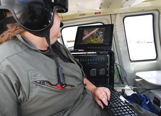
Margaret Bones had to wait for the rotor blades on the Bell Long Ranger helicopter to begin to whirr before there was electricity to power up her computer, cameras and sensors, but once the blades were spinning, she punched the buttons turning on her gear.
Bones and her pilot Raphel Perozo were headed to Indian Hills, a neighborhood east of Evergreen in search of wild re risks using high resolution cameras and laser radar, known as lidar.
e search has taken on heightened urgency in the wake of the 2021 Marshall Fire, the most destructive in Colorado history razing more than 1,000 Boulder County homes and businesses, tallying $2 billion in damages.
One cause of the re, county o cials concluded, was an Xcel Energy distribution line that had come loose in high winds. e utility has disputed that nding, but is already facing lawsuits from homeowners and businesses.
Still, electrical lines do pose a risk, the company noted in a ling with the Colorado Public Utilities commission, citing a 2019 study by Verisk Analytics that found one-third of the more than 2.2 million housing units in the state are in either moderate or high wild re risk areas.
at ranked Colorado third behind California and Texas for properties exposed to wild re danger.
And so, the hunt is on.
e use of lidar radar and computer analysis of the data it amasses are part of Xcel Energy’s Wild re Mitigation Plan, submitted to state regulators in 2019 and funded with $148 million in ratepayer dollars.
Bones, 27, an airborne systems oper- ator for Sandy Springs, Georgia-based GeoDigital, has own lidar runs all over the U.S. and Canada, sometimes collecting data for self-driving auto systems and sometimes for utilities checking their high-voltage transmission lines.

More and more of the work is checking smaller power lines, Bones said.
“LiDAR is more commonly applied to transmission lines,” Drew McGuire, director of research and development at the nonpro t Electric Power Research Institute, said in an email. “With increasing focus on wild re risk reduction, some utilities are nding ways to use this technology on distribution lines as well.”
McGuire said that these applications are emerging technologies. “Not all LiDAR is created equal,” he said. “ ey’re easy to use, but tricky to get ‘accurate’ data.” e project, begun in 2020, aims to cover 1,500 miles of distribution lines in more than 300 wild re risk zones by 2025. Last spring — spring is the prime time to do this work — the project scanned the San Luis Valley. is year it is scouring the foothills west of Denver. e work is painstaking as it can take multiple passes to complete one serpentine line. “On a good day we can do 20 miles of line, but usually only manage 12 to 15 due to afternoon storms,” Bones said.
Still, the experience with lidar is rising as the costs of the technology and data analysis decline. “New innovations to collect and process these data will likely make LiDAR application in distribution even more common in the future,” McGuire said.
Bones and Perozo are searching for possible problems with vegetation, inadequate clearance for lines and potentially overloaded poles.
On the belly of the Long Ranger — a bigger, more powerful version of the Bell Jet Ranger to deal with mountain turbulence — is the lidar sensor, three high resolution cameras and a near-infrared camera. ere is also a weather probe recording wind, temperature and humidity. e data ts into other Xcel Energy initiatives, such as its Mountain Hazard Tree Program focused on addressing tree mortality from pine bark beetles. e lines can be tested against simu- lated 90-mph winds. Would that catch a line being blown loose by the wind?
As they trace a line, Bones watches the images from the three cameras — one facing forward, one facing down and one facing aft — on her computer monitor. Once the line has cleared the rear camera, Bones knows the section is done.
At the same time the lidar — short for Light Detection and Ranging — is sending out laser pulses measuring distances and generating data that is the basis for a 3D representation of the lines and poles. e near-infrared camera can also identify unhealthy trees near lines.
All this data — up to four terabytes each day or the equivalent of uploading one million photos — is then used to create a 3D computer model of the distribution system by an Xcel Energy contractor, Fort Collins-based EDM International.
With the model the network can be stress tested for temperature, wind loads, and to see if lines are adequately spaced and whether poles are overloaded.
“We are looking for those inadequate clearances and overloaded poles,” said Andy Stewart, president of EDM International.
Finding potentially problematic poles without some kind of scanning would be a challenge in as much as Stewart estimated there are 89,000 poles in wild re risk zones.
After landing at Centennial Airport, Margaret Bones, an airborne systems operator for GeoDigital out of Atlanta, GA aboard a Bell 206 L4 Long Ranger helicopter, looks at some of the images on her computer taken near the foothills south of Chatfield Reservoir.
“Yes, LiDAR modeling enables Xcel Energy to identify poles within the wild re zone that could become overloaded due to strong winds,” the company said in a statement. “When these poles are identi ed, Xcel rebuilds these poles to Grade B Heavy loading of the National Electric Safety Code (NESC), which is the most conservative standard.” is story is from e Colorado Sun, a journalist-owned news outlet based in Denver and covering the state. For more, and to support e Colorado Sun, visit coloradosun.com. e Colorado Sun is a partner in the Colorado News Conservancy, owner of Colorado Community Media.
Property, of Article VI, City Property, of Chapter 2, Administration, of The Arvada City Code.
2023, at 6:15 p.m. at the Municipal Building, 8101 Ralston Road, Arvada CO, City Council will hold a public hearing on the following proposed ordinances and thereafter will consider them for final passage and adoption. For the full text version in electronic form go to www.arvada.org/legal-notices, and click on Current and recent Legal Notices to access legal notices. The full text version is also available in printed form in the City Clerk’s office. Contact 720.898.7550 if you have questions. The full text version is also available in printed form in the City Clerk’s office. Contact 720.898.7550 if you have questions.
CB23-019 An Ordinance Authorizing an Intergovernmental Agreement By and Among Apex Park and Recreation District, Jefferson County School District R-1 ("JCSD"), and the City of Arvada for JCSD's Priority Use of the George J. Meyers Swimming Center Replacement Facility.
Legal Notice No. 416602
First Publication: July 13, 2023
Last Publication: July 13, 2023
Publisher: Jeffco Transcript
Misc. Private Legals
LEGAL PUBLIC


