6 minute read
A Look at the Suburbs Map experts dig for roots of racial separation in metro Denver


BY ELLIS ARNOLD EARNOLD@COLORADOCOMMUNITYMEDIA.COM
In 1967, Black Americans were mired in “the long, hot summer.” Frustrations over poverty, unemployment, discrimination and myriad other issues spilled into the streets, leading to clashes with police and arrests in many places, including Denver. e widespread tensions over race left President Lyndon B. Johnson searching for answers.
So, he issued an executive order for a report that would detail what caused the chaos. He wanted it to answer a crucial question: How can the country prevent more unrest in the future?
When the report arrived seven months later, it laid out hundreds of pages of analysis and recommendations for improving race relations in America.
But its message was best summed up in a sentence:
“To continue present policies is to make permanent the division of our country into two societies: one, largely Negro and poor, located in the central cities: the other, predominantly White and a uent, located in the suburbs and in outlying areas.” ey’re trying to discover what many have either forgotten or swept under the rug about parts of the metro area — or simply never knew. ey’re digging in at the neighborhood level, looking for words in property documents — called “ra- cially restrictive covenants” — that excluded people from housing by race. ey’re looking to discern the legacies that still echo in communities today.
In other words, the issue of where people can live was at the heart of the report. It all ties into the American dream, the idea of a family owning a home, building wealth as that home increases in value over time and being able to live in whatever neighborhood a family can a ord without fear of discrimination.
Yet more than half a century later, that divide between Black and White residents continues to complicate the dream in many parts of America, including the suburban towns and cities that surround Denver. e divide is less stark and less known than it was in 1967, but its legacy is still alive in the metro area, where the Black population tends to live in Denver or Aurora, numbering in the tens of thousands in each city.
Elsewhere, Black residents number in the hundreds or just a few thousand while White residents make up strong majorities. White residents are 78% of the population in Arvada and 1% are Black. White residents are 80% of the population in Littleton and 2% are Black. White residents are 82% of the population in Castle Rock and less than 1% are Black.
So, why do the metro area’s communities look the way they do? e answer isn’t completely clear, but two map experts have delved into local property records, uncovering data that could help start to answer that question.
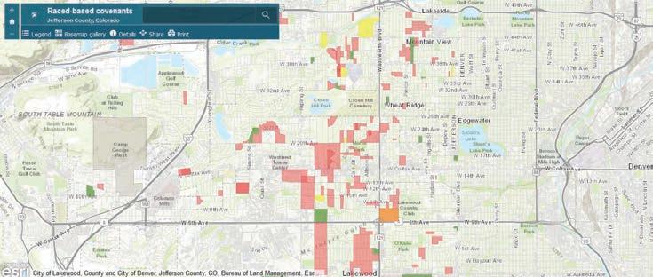
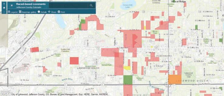
Christopher iry, a map librarian at Colorado School of Mines in Golden, is one of the diggers. Discovering the covenants in Je erson County shocked him.
“ at blew me away that this rural county at the time would have them,” iry said. “As I tell people, ‘Yeah, the suburbs of Birmingham, Alabama, sure. But Je erson County? Come on.’” iry has examined about 1,000 Je erson County documents and found nearly 200 had some kind of race-based stipulation. He looked at documents from the 1860s to 1950, though most of them were from the 1910s to 1950.
‘Only persons of the Caucasian race’ iry, a longtime resident of Golden, took inspiration from the “Mapping Prejudice” project, an effort at the University of Minnesota to identify and map racial covenants.
He jumped into his work after the killing of George Floyd by a Minneapolis police o cer. e mapping is a tedious task of sifting through mostly mundane, uncontroversial rules, like how many feet a house must sit away from the road or bans on billboards in front of homes.
Speci cally, he has pored over “plats,” or plans for new neighborhoods. e plat for one neighborhood — Cole Village, located along Colfax Avenue near Kipling Street in what’s now Lakewood — had this to say:
“Only persons of the Caucasian race shall use or occupy any building or any lot. is covenant shall not prevent use or occupancy by domes- tic servants of a di erent race.” e document was registered with the county in 1945. at type of racebased language is now unenforceable but remains on o cial plats, property deeds and other documents, according to iry.
It wasn’t just developers who pushed such language, iry said.
Local elected and appointed ofcials of the government of Je erson County signed the documents, iry added.
He singled out some other examples:
• “Ownership in this subdivision shall be restricted to members of the Caucasian race,” says a planning document for Sunshine Park in Golden at Sunshine and High parkways, dated 1944.
• “Stipulate that no lot at any time shall be occupied or owned by any person or persons not of the Caucasian races. However, this provision shall not prohibit the employment of persons of other races by the occupants,” says the plan for Green Acres along 6th Avenue in what’s now Lakewood, dated 1939.
• “No (area) shall at any time be occupied or owned by any person or persons of other than the Caucasian race, however, this shall not prohibit the employment of persons of other races on the premises by the occupants,” says the plan for Happy Valley Acres in the Golden area at South Golden Road and Orion Street, dated 1939.
• “ e said (land) shall (be) used for no other purpose than for the building and maintaining thereon and the occupancy thereof of private residences by Caucasians, and the erection of necessary outbuildings,” says a planning document for part of the Indian Hills area, dated 1923. iry has used his ndings to make a map of the parts of Je erson County where race-based rules were baked into the original plans of the housing developments. iry is wary that he may have missed pieces. ough the map is a work in progress, it already has him wondering how the covenants still in uence lives today.
Many are concentrated in what are now the Wheat Ridge and Lakewood areas, with a handful dotting the Golden and Arvada region. Others sit in the Evergreen and Indian Hills areas.
It’s not yet a complete picture.
Beyond that, what can be done to right past wrongs.
His work has made one measurable impact. It has inspired the work of another mapper, Craig Haggit, a map librarian at Denver Public Library.
Haggit, who is looking into where racist restrictions lurked in the paperwork for housing in Denver, also wants to shed light on “the way forward” for communities.
“I feel like we can’t know where we’re going until we know where we’ve been and how we got there,” Haggit said. “Otherwise, you’re just (in) the dark.” ough he doesn’t know yet, Haggit expects that the neighborhoods that were not redlined — the ones deemed higher class — would have the restrictive deeds because they were trying to keep certain people out.
It could take years to look through all the documents. But so far, Haggit’s work has revealed racial restrictions in Denver that targeted people in “a mix” of ways.
“Sometimes, it’s excluding ‘Negro’ or ‘Asian’ or ‘Mongoloid’ or whatever terms they used. And sometimes it just says only White people” can live in a certain house, Haggit said.

His team at rst zeroed in on the 1930s because the Ku Klux Klan was so active in the 1920s in the metro area. Since he’s in the early stages of the research, Haggit is unsure which neighborhoods were home to large concentrations of racially restricted housing.
One clue could be redlining, a term that refers to marking areas red on color-coded federal maps in the 1930s, re ecting the practice of restricting access to home loans in certain areas, partly based on race. at disparity stood in the way of homeownership for majority-Black areas and other groups in urban cities.
In Denver, redlining zeroed in on predominantly Black neighborhoods, but it also covered neighborhoods where other ethnic or religious groups were present, according to the Denver redline map as displayed by the “Mapping Inequality” project from the University of Richmond and other university teams.
Denver’s redlined areas at the time included some western parts of the city and areas that surrounded downtown. But the map also redlined a small part of Aurora along Colfax Avenue — and parts of west and central Englewood. (A sliver of Je erson County in the Edgewater