HARLEM AVENUE VISIONING STUDY

COMMISSIONER STATEMENT LAND ACKNOWLEDGEMENT
Placeholder text space for Commissioner Statement
The City of Chicago is located on land that is and has long been a center for Native peoples. The area is the traditional homelands of the Anishinaabe, or the Council of the Three Fires: the Ojibwe, Odawa and Potawatomi Nations. Many other Nations consider this area their traditional homeland, including the Myaamia, Ho-Chunk, Menominee, Sac and Fox, Peoria, Kaskaskia, Wea, Kickapoo and Mascouten. The City specifically acknowledges the contributions of Kitihawa of the Potawatomi in fostering the community that has become Chicago. We acknowledge all Native peoples who came before us and who continue to contribute to our city. We are committed to promoting Native cultural heritage. Adopted by the City of Chicago, November 17th, 2021.





PROJECT OVERVIEW 1
STUDY AREA
THE HARLEM AVENUE CORRIDOR
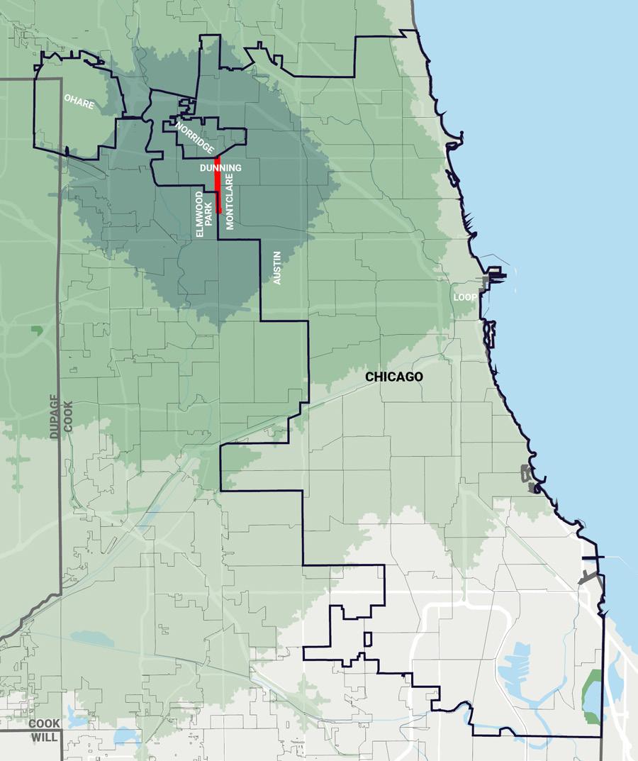
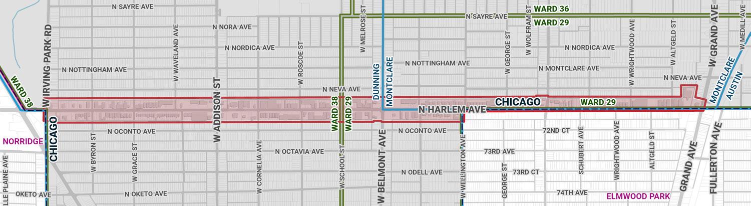
Located in the Northwest side of Chicago, the Harlem Avenue Visioning Study area consists of a two-mile stretch of Harlem Avenue, spanning from Grand Avenue to Irving Park Road within Chicago’s Montclare and Dunning Community Areas. The area is well connected via several state routes: I-90 is only two miles north of the Corridor, I-294 is four miles to the west, I-94 is three and a half miles to the east, and I-290 is three and a half miles to the south. Driving via these expressways, motorists are about six miles from O’Hare International Airport, and less than 13 miles to the Loop, the City’s Downtown area.
Since the mid-20th century, Harlem Avenue has been one of the key commercial corridors in Northwest Chicago. It is classified as a principal arterial roadway and carries over 20,000 vehicles per day. The study area comprises various commercial, institutional, educational, mixed-use, and residential properties.
From Wellington Avenue to Grand Avenue, the west side of Harlem Avenue is part of the Village of Elmwood Park with the east side within the City of Chicago city limits. Despite this boundary line, the community of Harlem Avenue sees itself as one.
Harlem Avenue is also an Illinois State Route (43) and a designated truck route by the Illinois Department of Transportation (IDOT). Any future design proposals will require coordination and approval between IDOT, Chicago Department of Transportation (CDOT), Chicago Transit Authority (CTA), Chicago Department of Planning and Development (DPD), and the Village of Elmwood Park.
PURPOSE, GOALS, AND SCOPE
The need for a visioning study stemmed from the desire to enhance the public realm and to help strengthen the local Italian business community, the Harlem Avenue Little Italy Business Association (HALIBA). The purpose of this study is to inspire a ‘big picture’ vision for potential future projects along Harlem Avenue and to identify areas of greatest need, opportunities, and aspirations based on local input.
Project goals were established to create a unique and inspiring vision for the Harlem Avenue Corridor.
This study aims to:
- Create a vision for public improvements along the Harlem Avenue Corridor.
- Build an identity for the commercial Corridor by establishing a brand that celebrates the history, culture, and community of Harlem Avenue.
- Strengthen the small business community by increasing the public’s knowledge and awareness of Harlem Avenue and HALIBA.
- Outline a framework for implementation to help guide the future of Harlem Avenue.
This Visioning Study will not be a mandate for the city, an ordinance, or a hindrance for flexibility or creativity for future improvements.
Over the course of the Visioning Study, the study team analyzed the existing conditions of the Corridor, including the built environment, public realm, demographics, market trends, recent development, and existing zoning and regulations. After initial findings, the team developed guiding principles and strategies to guide public realm recommendations and conceptual development visions for three focus areas along the Corridor. The visions and implementation framework for these focus areas are detailed in the “Recommendations and Implementation Framework” chapter, starting on page 23 . Please note: These visions are for illustrative purposes only, and will require additional studies, community engagement, cooperation with property owners, funding allocation, design and engineering approval before future improvements can be implemented.
Figure 2. Map of Harlem Avenue visioning study area Figure 1. Harlem Avenue visioning study regional context
STUDY TEAM AND TIMELINE
ENGAGEMENT PROCESS
OVERVIEW
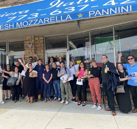
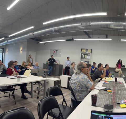
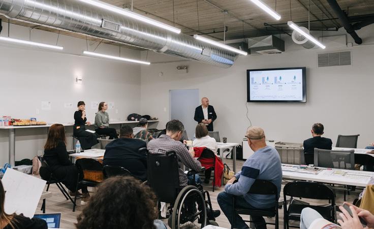
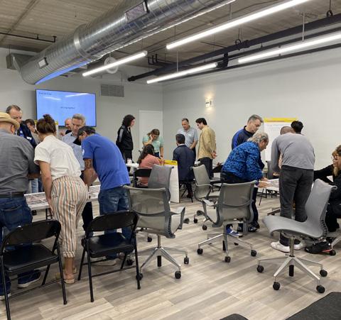
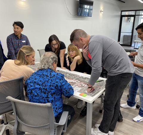
The study included an initial working group site visit walk and four working group meetings to gather feedback. The working group participants consisted of representatives from the City of Chicago departments and sister agencies, the Village of Elmwood Park, and the Illinois Department of Transportation; elected officials; local business owners from HALIBA; property owners; and residents.



Working Group Site Walk
Working Group Meetings
# of Working Group Participants
Figure 9. Working group meeting 3
Figure 5. Initial working group site walk
Figure 7. Working group meeting 2
Figure 6. Working group meeting 1
Figure 8. Working group meeting 2
Figure 11. Working group meeting 4
Figure 10. Working group meeting 3
Figure 12. Working group meeting 4
CORRIDOR OVERVIEW 2
HISTORY OF THE CORRIDOR
the last quarter of the 19th century with the arrival of the Chicago & Pacific Railroad (C&P) in 1872. In 1873, a nearby farm was platted by developers and named Montclare, though further development was stifled within the year following the acquisition of the C&P by the Chicago, Milwaukee St. Paul & Pacific Railroad, which reduced commuter service to a single daily train and, in turn, reduced the desirability of the area.
Harlem Avenue has served as a major thoroughfare and commercial center for Chicago’s Northwest Side for nearly a century. Nonindigenous settlement in the area dates back nearly 200 years, when Montclare was first settled by William Sayre in 1836. Sayre and later settlers were farmers who predominantly grew oats and corn. They used Grand Avenue as their main thoroughfare to the downtown markets in Chicago.
Fifteen years later, the first major development in the area now known as Dunning was constructed when Cook County opened the Cook County Hospital for the Insane on 160 acres of remote prairie bounded by Irving Park Road and Narragansett, Montrose, and Oak Park avenues. Following the Civil War, Andrew Dunning purchased 120 acres immediately south of the county hospital to build a nursery and lay the groundwork for a village, though proximity to the hospital remained a deterrent. New developments were then spurred during
In the 1880s, several key events occurred that would alter the development patterns of Montclare and Dunning. In 1882, the Milwaukee Road established a single, three-mile track extension to the county hospital, which in turn encouraged the county to build a new station in the area to serve employees and commuters, naming it Dunning. By the end of the 1880s, Montclare and Dunning were annexed to the City of Chicago as part of Jefferson Township. Around the turn of the century, Henry Kolze inherited a tavern and woodlands at Narragansett Avenue and Irving Park Road, which he converted into a picnic grove. The pastoral and idyllic scenery and tavern attracted new visitors, and with the opening of Irving Park Boulevard brought renewed interest in the far Northwest Side communities. Development interest was followed by additional improvements in the early 1900s with the extension of the Grand Avenue streetcar line into the area in 1912, the creation of Rutherford Sayre Park in 1916, and utilities and paved roads in the 1920s.
In 1916, the first housing boom occurred when Schorsch Brothers Real Estate bought a tract west of Austin Avenue and south of Irving Park Road. At the same time, Montclare’s lots were now being sporadically developed with single-family structures. New residents found employment at industrial plants along the rail line, while most commuted into neighboring communities where factories were more plentiful. Residents were primarily of Swedish, English, German, and Polish descent. Housing development in the area flourished north to Diversey Avenue in the 1930s. Commercial development remained slow prior to World War II and was concentrated in a small district at Grand and Harlem avenues.
In the mid-20th century, commercial development began to spread north along Harlem Avenue with the post-World War II proliferation of the automobile and the Corridor’s location along Illinois Route 43 (formerly IL Route 42A), which was established two decades earlier. Simultaneously, the community experienced an influx in population as the Italian community in Chicago’s Near West Side Community Area was bifurcated by Interstate 290/Dwight D. Eisenhower Expressway beginning in 1955. Italian families moved north and west, creating a residential boom in Montclare and Dunning, and opened new commercial enterprises along Harlem Avenue, including specialty grocers, bakeries, and restaurants.
Lots on Harlem Avenue that remained undeveloped in the 1950s were improved with new multi-building apartment complexes and autooriented commercial developments in the 1960s and 1970s, which is reflected in the diverse mid-20th century building stock along Harlem Avenue that we see today. By the end of the 20th century, the area would experience additional population growth as new groups moved into the area, including Greeks, Ukrainians, Lithuanians, Lebanese, and Hispanics, adding to the diversity and vibrancy of the area. With the influx of population, the community moved toward a revival of institutional, commercial, and residential growth still seen on Harlem Avenue today as new multi-unit apartment buildings were constructed and new commercial enterprises revitalized historic storefronts.
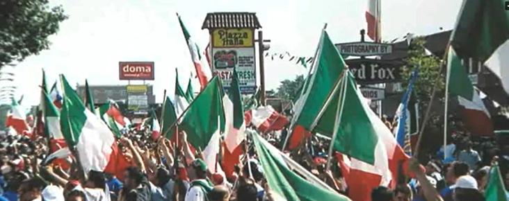
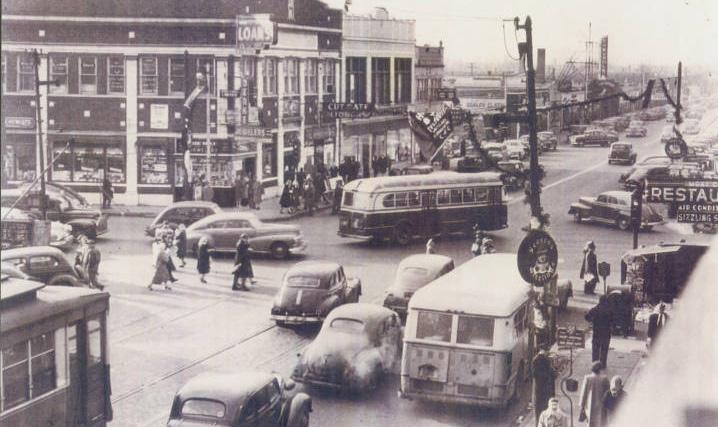
Figure 13. Corner Of Grand Avenue And Harlem Avenue, 1949 (Source: Elmwood Park Public Library)
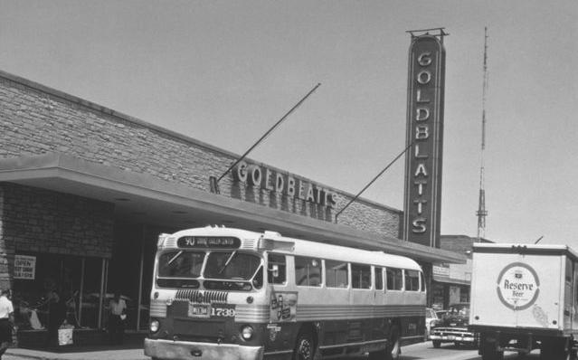
Figure 14. Goldblatts At Grand Avenue And Harlem Avenue, 1948 (Source: Ronald J. Sullivan via Northwestern Libraries)
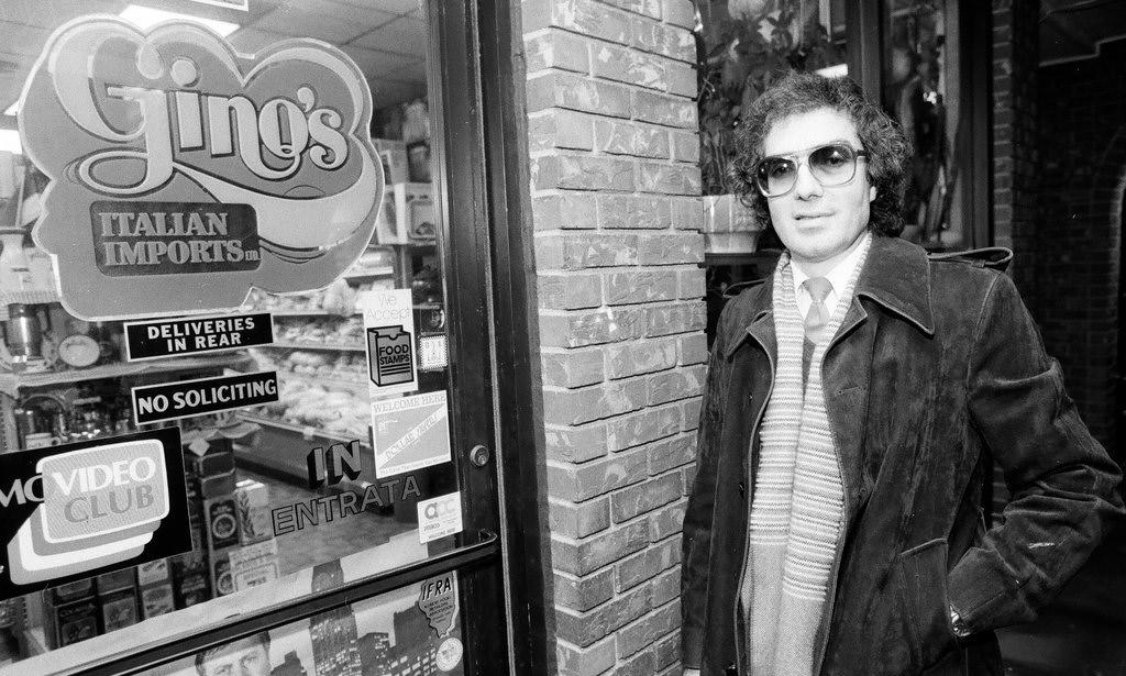
Figure 15. Geno Bartucci outside of Geno’s Import Foods at 3422 N Harlem Avenue in 1985 (Source: Chicago Sun Times)
Figure 16. Harlem Avenue Little Italy Celebration (Source: Cathy Vlahogiannis, Vimeo, Posted 2013)
DESCRIPTION OF THE BUILT ENVIRONMENT
Harlem Avenue’s built environment is defined by several components encompassing both public streetscape improvements and privatelyowned commercial and residential buildings. The following sections provide detailed descriptions of the commercial and residential architecture and public realm, which contribute to the Corridor’s vibrant character and dynamic sense of place.
IDENTITY AND ARCHITECTURE:
Commercial
As part of a historic and well-established commercial corridor, the Harlem Avenue buildings reflect traditional commercial building forms, which are typically freestanding or joined by party walls, with the commercial business on the first floor and offices or residences above.
The commercial building, as a form, almost always fits on its entire lot and is built to the sidewalk. In a pre mid-20th century business district, commercial buildings are densely clustered together on small blocks, oriented to the street and sidewalk. With the advent of the automobile, commercial buildings began to shift to larger, sprawling footprints setback from the street and sidewalk with adjacent parking to accommodate visitors arriving by cars. As the historic development of Harlem Avenue spans from the 1920s to the 1980s, this shift in commercial building forms is evident in the existing built environment.
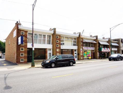
Commercial development constructed during the early 20th century to the beginning of the mid-20th century follows the one and two-part commercial block form. The commercial block is the most common type of composition used for small and moderate-sized commercial buildings throughout the country. The two-part commercial block is typically limited to buildings that are two to four stories in height. This type is characterized by a horizontal division into two distinct zones, a lower and an upper zone. Each zone received its own design treatment that, while clearly separated from one another, may still look harmonious, or they may have little visual relationship. The two-part division reflects the differences in use: The lower zone is located at street level and includes public spaces such as retail stores, a banking room, or medical offices. The upper zone houses more private spaces, including offices or residential units.
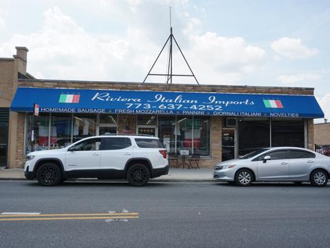
Treated in a similar manner as the lower zone of a two-part commercial block is the one-part commercial block. This type is only one story in height and is typically a simple box in plan with an ornamented facade. The facade is predominantly composed of plate glass windows and surmounted by a cornice or parapet.
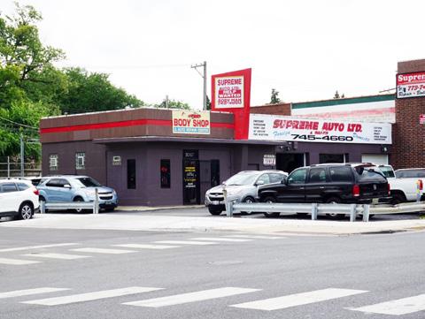
As commercial design forms adapted to the automobile during the mid-20th century, building design shifted from the commercial block to the freestanding type, which is typically larger and withdrawn from the pedestrian and public realm experience. Freestanding buildings are typically one story and occasionally two stories, and have architectural treatment on three or more sides. Commercial buildings accommodating automobile access usually oriented entry points for parking areas from a side street or a vehicular drive that separates the pedestrian right-of-way and the main entrance. The structure may occupy an entire city block and be surrounded by parking on one or more sides.
Residential
While the Corridor is predominantly commercial, as lots fronting Harlem Avenue remained undeveloped into the mid-20th century, residential development was built along the Corridor during the 1950s-1970s.
The extant residential development along the Corridor today dates from the mid-20th century, with newer early 2000s residential complexes interspersed. Typical residential forms include Ranch and Raised Ranch residences and multi-building apartment building complexes, both common during the mid-20th century. There also remain a few intact early 20th century residences along the Corridor, which reflect the earliest type of development along Harlem Avenue. These residences include frame cottages and bungalows, which were popular during the early 1900s.
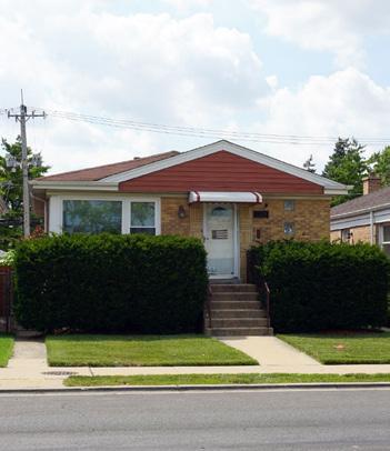
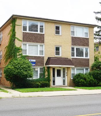
Figure 18. Two-part commercial block3815-21 N Harlem Avenue
Figure 17. One-part commercial block3220 N Harlem Avenue
Figure 21. Multi-unit apartment3025-27 N Harlem Avenue
Figure 20. Raised ranch-style home3758 N Harlem Avenue
Figure 19. Freestanding/auto-oriented3067 N Harlem Avenue
PUBLIC REALM AND PEDESTRIAN EXPERIENCE
Harlem Avenue follows a north-south alignment with intersecting arterial roads such as Belmont Avenue, Addison Street, and Diversey Avenue every half mile and local streets, including Waveland, Cornelia, and Wellington avenues, approximately every one-eighth mile, creating a standard street grid.
The width of the Harlem Avenue Corridor right-of-way (ROW) is 66 feet, accommodating one lane of travel in either direction and on-street parking lanes, with sidewalks flanking either side of the roadway. Light poles have been installed at regular intervals along the east side of the Corridor. Sidewalks are narrower in front of residential buildings to accommodate grass parkways that serve as a buffer between the
roadway and the sidewalk. The parkways are irregularly planted with or without trees and at times, the grass has been replaced with concrete.
Landscaping on Harlem Avenue is most prominent on private property in the form of saplings, low shrubs, and flowering plants along a fence line or a front setback of a property. Most raised bed landscaping is located at corners of major intersections.
Other sidewalk amenities include “U” shaped bike racks and the occasional bus stop shelter or bench serving the #90 Harlem Avenue CTA bus route.
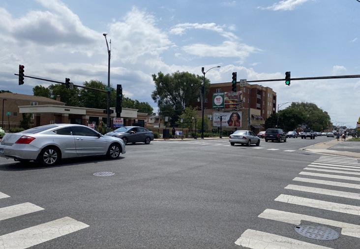
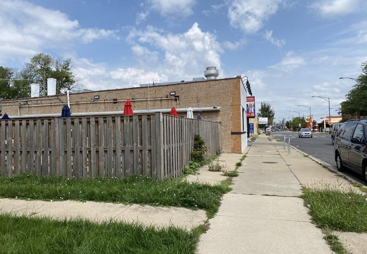
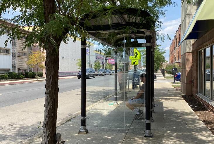
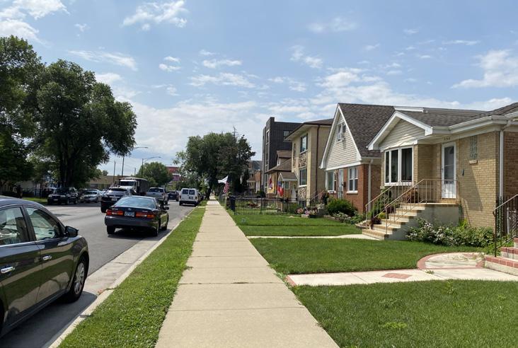
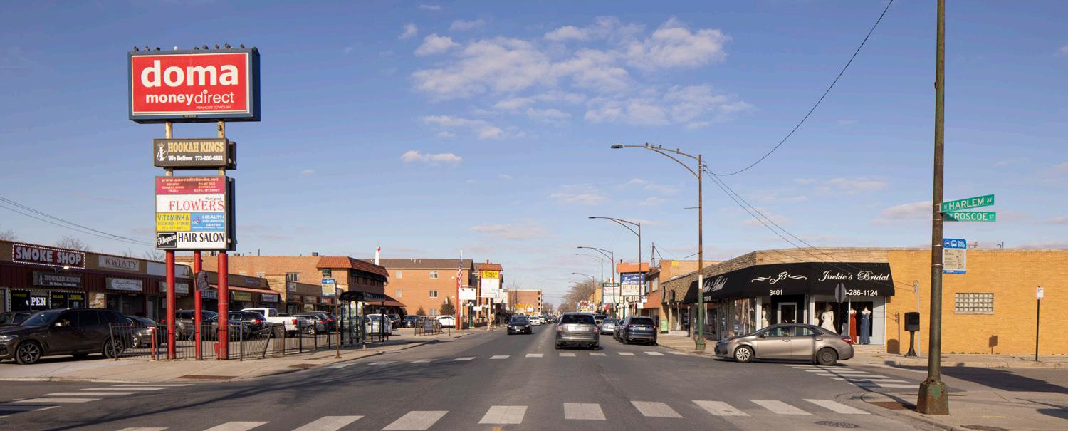
Figure 22. Public realm and pedestrian experience along Harlem Avenue between Cornelia and Roscoe
Figure 23. View of Harlem Avenue at Addison Street
Figure 25. Bus shelter along Harlem Avenue
Figure 24. Sidewalk along a commercial area of Harlem Avenue
Figure 26. Sidewalk along a residential area of Harlem Avenue
DEMOGRAPHIC, SOCIOECONOMIC, AND WORKFORCE SUMMARY
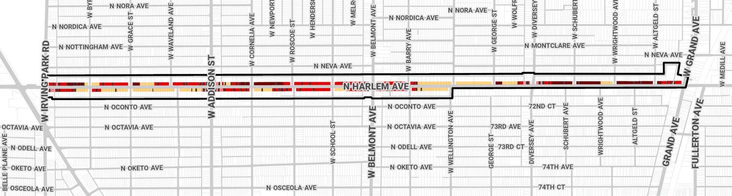
To better understand demographic and market trends, a “market area” was identified that extends a half-mile in each direction from the study area, as shown in the below map with a red dashed line. The market area covers portions of Dunning and Montclare, along with neighboring municipalities Elmwood Park and Norridge. This delineation serves to capture and analyze broader trends impacting the study area.
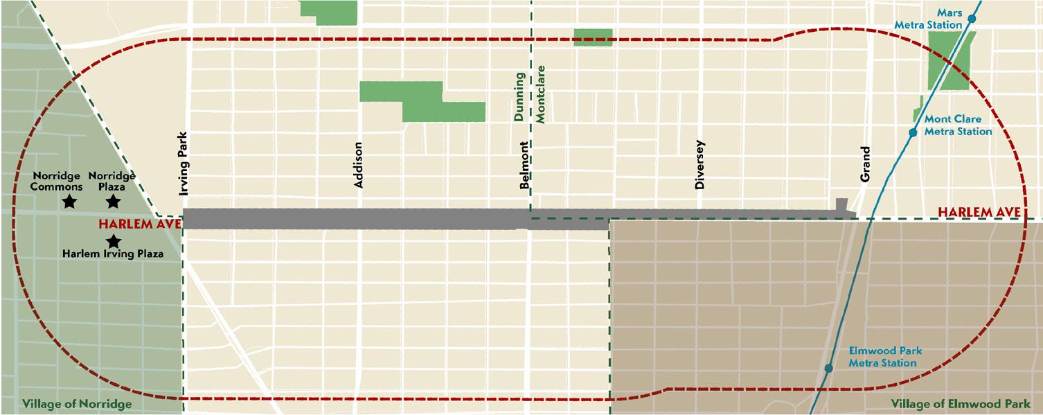

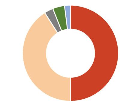
Figure 28. Race and ethnicity in the Harlem Avenue Corridor market area (Source: US Census, 2020)
DEMOGRAPHIC & EMPLOYMENT IN MARKET AREA – KEY FINDINGS
Demographics:
The market area experienced limited population growth between 2010 and 2020, although recent estimates indicate a slight population decline between 2020 and 2023. Since 2010, however, the market area has become more diverse, with a fast-growing Hispanic population that now makes up more than 40% of the market area. The median age is rising, potentially due to aging residents staying in place, younger households moving elsewhere, or an influx of residents aged 55 and above. The median household income in 2023 was $74,434, surpassing the City of Chicago’s median income of $65,781.
Figure 29. Leading employment industries in the Harlem Avenue Corridor market area, 2002-2020 (Source: US Census, 2010 and 2020; Esri Business Analyst Estimates, 2023)
Employment:
The market area has lost nearly 4,000 jobs since its peak of 10,792 in 2006, with 6,878 jobs estimated in 2020. The decline in jobs since 2015, exacerbated by the COVID-19 pandemic, has impacted retail, food services, and other sectors. While retail remains a leading industry, it has experienced a loss of 1,500 jobs since the high in 2008. Most workers commute less than 10 miles to their job in the market area, many coming from Chicago and other nearby municipalities.
Figure 27. Harlem Avenue market area map
RESIDENTIAL MARKET ANALYSIS – KEY
FINDINGS
Esri Business Analyst estimates nearly 750 residential units in the study area, with the majority being owner-occupied in condominium buildings or three-flats. Only 29% of the housing inventory consists of rental apartment units, reflecting a predominantly owner-occupied landscape. The low residential vacancy rate of 3% suggests a stable housing market, notably lower than the 5% rates in both the market area and the city as a whole. Over the past two decades, 14 new residential developments have been built in the Study Area. Ten were for-sale condominiums, and four were rental apartments.
Examining for-sale market trends, the study area offers more affordable options than elsewhere in the city, with an average sale price of $330,000 below the citywide average of $446,000 in 2023. New developments during the last two decades have predominantly featured multi-story condominium buildings with ground-floor units.
In terms of multifamily rental trends, there are fewer rental options than for-sale. Recent additions have brought the total to 218 rental units to the study area. Rental apartments in the study area have an average asking rental rate of $1,450, below the citywide average of $1,700. Notably, half of these apartments were constructed in the last 10 years within four new developments. All of them include ground-floor units.
COMMERCIAL MARKET ANALYSIS – KEY FINDINGS
Residents in and around the study area are well served by retail, especially in nearby shopping centers catering to a variety of consumer needs, such as the Harlem Irving Plaza, Norridge Plaza, and Norridge Commons. These large shopping areas, located north of the study area, attract national tenants due to their advantageous locations with high traffic counts, visibility, and ample parking. Importantly, these retail hubs complement rather than compete with the study area’s commercial establishments, which are predominantly smaller local businesses, service-oriented venues, and eateries.
The study area has 330,000 square feet of commercial space, encompassing retail storefronts in free-standing buildings, mixeduse structures with residential units above, and strip centers. With a low overall vacancy rate of four percent, as reported by CoStar, and average asking rental rates slightly above $19 per square foot NNN (triple net), the commercial landscape is characterized by affordability compared to the City’s average of $26 per square foot. Notably, onethird of storefronts are located in the Corridor’s nine free-standing strip centers, totaling more than 105,000 square feet and featuring off-street parking for shoppers.
There has been limited commercial development in the study area since 2000, with only four new additions. Three of the new commercial spaces are free-standing buildings with a drive-thru component, including two banks and a coffee shop, and one is ground-floor retail in a mixed-use building at 3016 N. Harlem Ave., offering four smaller retail storefronts, three of which were vacant in early 2024.
Business Mix:
In the study area, personal and professional services dominate, comprising 28% of all storefronts, with a focus on local businesses such as tax, finance, insurance, and legal services, as well as hair and barber shops. Eating and drinking places, totaling 36 storefronts, present a mix of local bars, eateries, cafés, and national fast-food chains, reflecting a diverse culinary landscape with Italian, Hispanic/Latino, and Middle Eastern representation. Retail stores, accounting for 19% of storefronts, predominantly feature local businesses specializing in home goods, furnishings, clothing, accessories, vape products, and specialty food and beverages. Automotive uses, while representing only seven percent of storefronts, occupy larger spaces and include a car wash, auto repair shops, parts retailers, tire shops, and gas stations.
At the time of the business inventory in October 2023, only 33 of the 187 storefronts were vacant. Note that the aforementioned estimated four percent retail vacancy rate from CoStar is based on total square footage, not number of storefronts. Clusters of vacant storefronts are found between Addison and Belmont, where the concentration of commercial storefronts is highest. Many of the vacant storefronts in the study area are in small retail spaces of 1,500 square feet or less.
Within the study area, 15% of the active businesses in the study area are Italian-American owned, 13 of which are eating and drinking places and 10 other businesses that include service uses, auto uses, and retail stores. Note that the National Italian American Sports Hall of Fame at 3417 N. Harlem Ave. is expected to open in 2024, increasing the number of Italian-American owned businesses, and will bring more visitors to the area. The Harlem Avenue Little Italy Business Association (HALIBA), is the active business group in the study area.
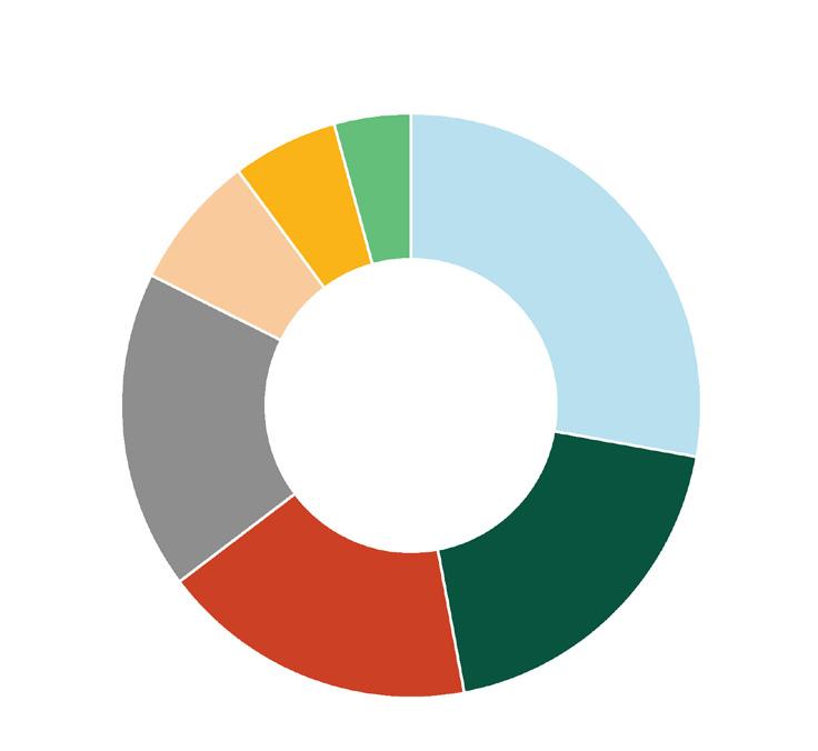
Figure 30. Business mix in the Harlem Avenue Corridor market area. Inventory, October 2023
EXISTING ZONING AND REGULATIONS
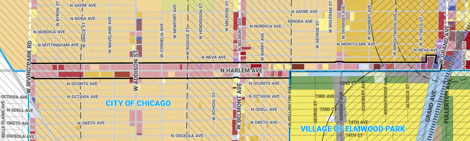
Figure 31. Existing zoning of the Harlem Avenue Corridor
While the eastern side of Harlem Avenue is entirely within the City of Chicago, the western side is part of the City of Chicago between Irving Park Road and Wellington Avenue and is part of the Village of Elmwood Park between Wellington and Grand avenues. This Visioning Study only includes parcels within the City of Chicago limits, however, the Corridor should have a cohesive, singular experience regardless of the municipality that governs each side of the street. This summary studies the existing zoning and regulations in a comprehensive way, regardless of the municipality.
MAJOR TAKEAWAYS FOR BOTH JURISDICTIONS
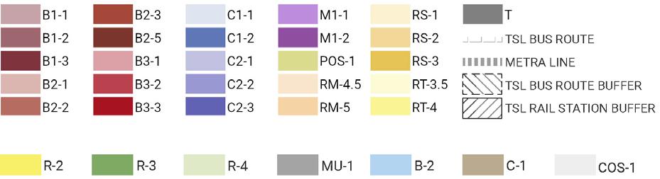
- Within the study area, Harlem Avenue spans two municipalities and 18 unique zoning districts (15 City of Chicago/ three Village of Elmwood Park), which results in a lack of consistency throughout the Corridor.
- Building height maximums for one side of the street often do not match building height maximums for the other side of the street.
MAJOR TAKEAWAYS FOR CITY OF CHICAGO ZONING
- The Connected Communities Ordinance (2022) allows for significantly increased densities and parking reductions in areas designated as Transit-Served Locations (TSL). As a result, it is anticipated that redevelopment activities will generally be focused in these areas.
- Approximately 50% of the Corridor is designated as a TransitServed Location (TSL), including the following:
- Within ¼ mile of CTA bus route # 80 Irving Park
- Within ¼ mile of CTA bus route #77 Belmont
- Within ½ mile of the Elmwood Park and Mont Clare Metra stations
- Portions of the Corridor are identified as Inclusionary Areas according to the City’s Affordable Requirement Ordinance (ARO) and could be leveraged to build more housing. The ARO requires residential developments with 10 or more units that receive City Council approval for entitlements, a city land purchase or financial assistance, to provide a portion of its units as affordable housing.
- Further analysis of the existing zoning designations along the Corridor should be taken to minimize non-conformities, create predictable and consistent regulations for the Corridor, and provide a degree of development rights that allow a community to grow without requiring subsequent map amendments.
MAJOR TAKEAWAYS FOR VILLAGE OF ELMWOOD PARK ZONING
- The limited areas of Harlem Avenue that are zoned RS-3, RT-4, and RM-5 do not provide enough flexibility for housing density or commercial activity that is reflected in other parts of the Corridor.
- The B3-1, B3-2, and B3-3 zoning districts are appropriate for Harlem Avenue, however, with FARs that range from 1.2 to 3, they are too low to support viable, mixed-use development.
- Parking requirements vary in the B3-1, B3-2, and B3-3 zoning districts, but generally, they require too many parking spaces for a walkable environment.
- Often the maximum building height permitted in Elmwood Park is higher than the maximum building height permitted across the street in the City of Chicago. For example, the B-2 zoning district in Elmwood Park permits a maximum building height of 75 feet, but the B3-1 zoning district across the street in Chicago permits a maximum zoning height of 38 feet. This could result in incompatible development patterns.
CITY OF CHICAGO ZONING & TSL
VILLAGE OF ELMWOOD PARK ZONING
RECOMMENDATIONS AND IMPLEMENTATION FRAMEWORK
GUIDING PRINCIPLES
The Guiding Principles for Harlem Avenue were carefully crafted following extensive discussions with local collaborators to identify current issues and desired improvements. These discussions, combined with a thorough analysis of the corridor’s existing conditions, informed the elaboration of the three main principles that guide the Harlem Avenue Visioning Study: Public Improvements, Corridor Identity, and Community Gathering. The following pages depict different strategies that have been identified to achieve these principles.
PUBLIC IMPROVEMENTS
The study envisions a future for Harlem Avenue as a thriving mixed-use corridor that harmoniously caters to the needs of both pedestrians and vehicles. Over time, the street has been designed to prioritize vehicular traffic. To effectively shift the focus towards pedestrians, several key improvements are necessary. Placing greater emphasis on the public sidewalk within the Right-of-Way (ROW) will be crucial, which can be achieved by strategically reducing the widths of on-street parking and driving lanes. Reclaiming space for pedestrian use will allow for the creation of protective buffers between pedestrians and vehicular traffic. Additionally, this reallocation of space will contribute to the overall beautification of the corridor, fostering a more vibrant and inviting atmosphere.
Goals:
- Improve pedestrian safety and circulation by adding traffic calming measures, identifying locations of pedestrian crossing concerns, and adding new light poles.
- Improve CTA bus safety, operations, and bus stop accessibility.
- Strengthen the business corridor by making the area more inviting to pedestrians by enhancing public improvements and streetscape infrastructure.
- Enhance the public streetscape by incorporating green infrastructure and making landscape improvements as outlined in the Chicago Landscape Ordinance.
- Build strong partnerships within a multijurisdictional area.

CORRIDOR IDENTITY
A consistent brand and design approach is needed to commemorate the history of Italian business presence along the corridor, drive investment, and define an identity.
Goals:
- Define the identity of the corridor.
- Develop a consistent brand and design approach considering the cultural history and people that live within the community today.
- Develop redevelopment strategies considering short and longterm interventions for improvements.
- Improve signage and wayfinding along the corridor.

COMMUNITY GATHERING
To foster a vibrant and welcoming public realm, the Harlem Avenue Visioning Study proposes the creation of signature spaces known as “The Community Heart” and “The Community Hubs.” These strategically located focus areas will serve as anchors for neighborhood activity, providing spaces for visitors, businesses, and residents to gather, connect, and celebrate. The Heart and Hubs will be easily accessible via public transportation and situated around currently active business nodes, intersections with redevelopment potential, and opportunity sites for multipurpose open space. The key to the success of these focus areas is the emphasis on creating ample public space and inviting gathering areas.
Goals:
- Create new open spaces, plazas, and multi-purpose areas.
- Identify existing underutilized spaces that can be used for temporary activations.
- Program these spaces with vibrant events, gatherings, and markets for the community and visitors alike.
PUBLIC IMPROVEMENTS
RIGHT-OF-WAY (ROW)
The ROW, which encompasses sidewalks, roadways, and public open spaces, plays a crucial role in shaping a community’s character and vitality.
Within the study area, Harlem Avenue has a standard 66-foot wide ROW, and the current condition along the Corridor is centered around the vehicle. The future vision, depicted in Figure 32 and Figure 33 includes improvements to the ROW by proposing consistent travel and parking lane widths, shortening crosswalk distances by proposing bumpouts where possible, relocating bus stops to the far side of the intersection where possible, enhancing existing crosswalks, raising crosswalks at local side streets, adding light poles, and adding bus shelters at major intersections. By implementing these strategies throughout the entirety of the corridor, the pedestrian and vehicular experience and safety will improve.



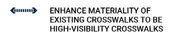


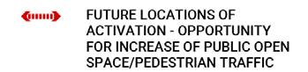





Figure 32. Harlem Avenue Corridor overall pedestrian experience improvement opportunities
Figure 33. Harlem Avenue Corridor overall vehicular experience improvement opportunities
CIRCULATION AND SAFETY
The corridor currently has four main ROW typologies. The following cross-sections on pages 28 -31 depict typical existing conditions of those typologies and the future vision. The existing cross section
dimensions are shown approximate and shall be verified in the field.
The future vision for the roadway is to create consistent travel lane widths at 12’ wide, consistent parking and bumpouts at eight feet, plant trees where possible in areas that do not currently meet the Chicago Landscape Ordinance, and add light poles.
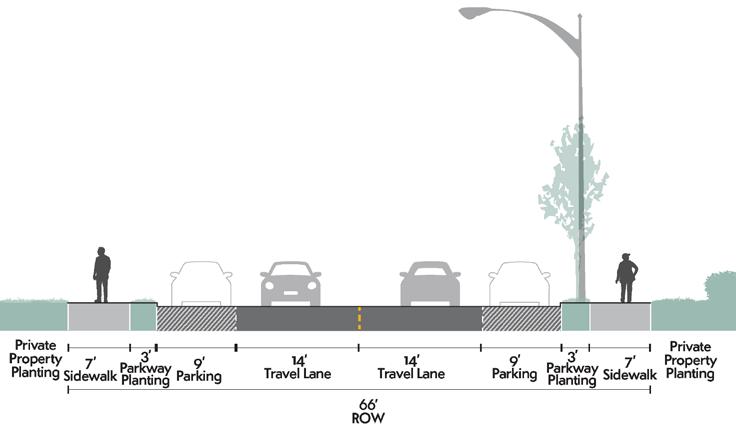
Typical residential typology with five feet wide parkway planting areas and six feet wide sidewalks.
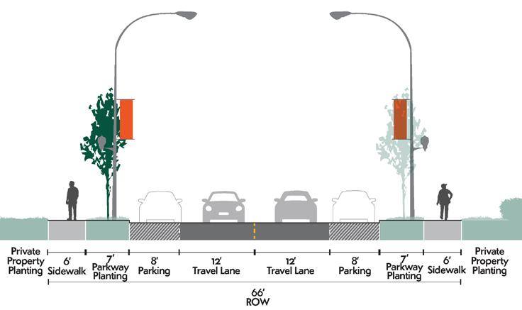
Consistent 12’ wide travel lanes, eight feet wide parking lanes, seven feet wide parkway planting areas to meet the Chicago Landscape Ordinance, and six feet wide sidewalks.
Note: Any future visions would require further design study and approvals by IDOT and CDOT. IDOT will require future studies to consider the implementation of a three-lane or five-lane roadway cross-section due to the existing, and likely future, traffic volumes. A traffic engineering study will be required for any proposed bumpouts, medians, lane changes, and other updates that fall within the public ROW and affect vehicular traffic flow. All proposed bumpout widths will need to be determined based on the autoturn analysis of a firetruck and a WB-65 design vehicle.
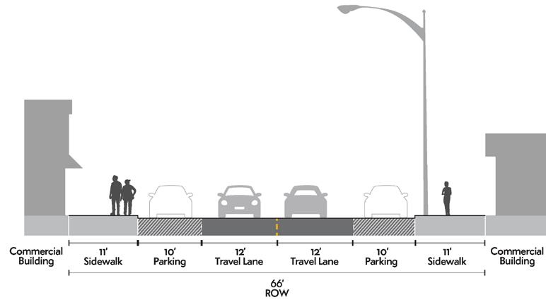
Typical commercial typology with nine feet or wider sidewalks.
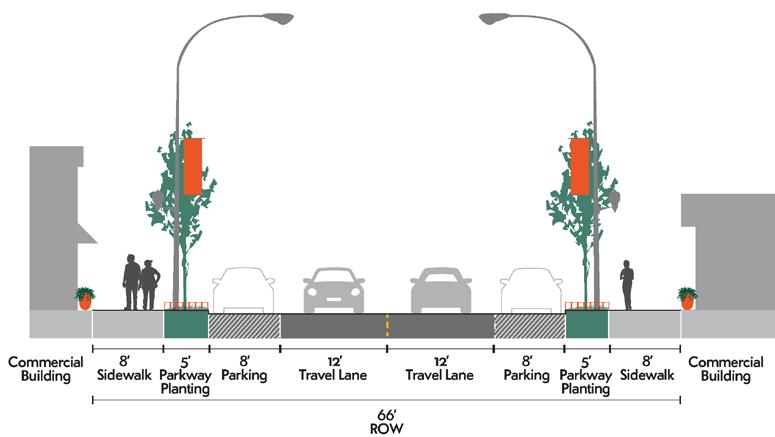
Consistent 12’ wide travel lanes, eight feet wide parking lanes, five feet wide parkway planting areas to meet the Chicago Landscape Ordinance, and eight feet wide sidewalks, creating a more visually appealing and inviting streetscape.
Figure 34. Typical residential Harlem Avenue
LOCAL INTERSECTION MAJOR INTERSECTION 3 4
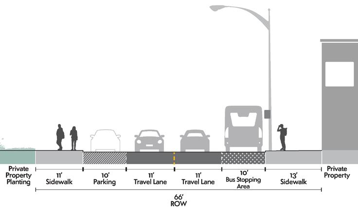
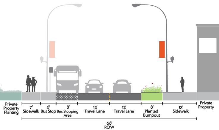
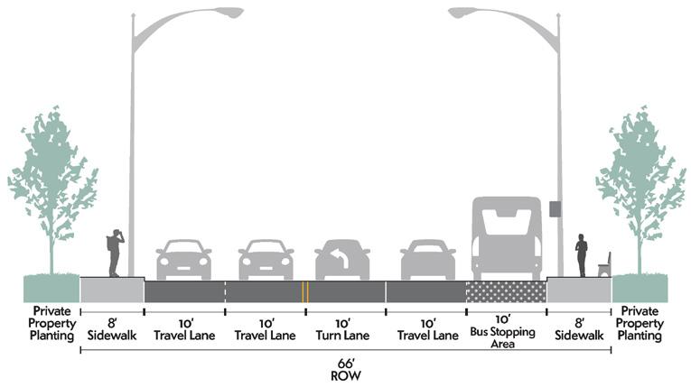
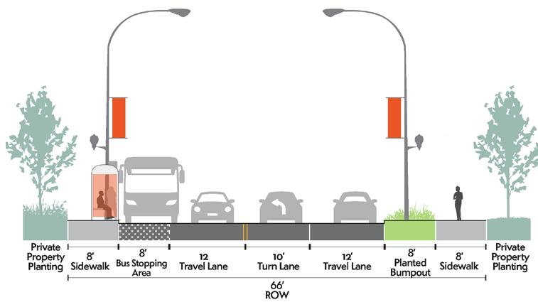
Note: Any future visions would require further design study and approvals by IDOT and CDOT. IDOT will require future studies to consider the implementation of a three-lane or five-lane roadway cross-section due to the existing, and likely future, traffic volumes. A traffic engineering study will be required for any proposed bumpouts, medians, lane changes, and other updates that fall within the public ROW and affect vehicular traffic flow. All proposed bumpout widths will need to be determined based on the autoturn analysis of a firetruck and a WB-65 design vehicle.
Figure 36. Typical local intersection Harlem Avenue Corridor ROW typology
Figure 37. Typical major intersection Harlem Avenue Corridor ROW typology
GREEN INFRASTRUCTURE
Green infrastructure is a term used widely to describe several sustainable interventions. Within this document, green infrastructure describes a system of using permeable surfaces to process rainwater on-site, where water hits the ground, instead of using underground pipes to ship water away (definition by the U.S. EPA). At the local street and neighborhood scale, green infrastructure encompasses many different interventions that reduce the risk of flooding, help filter stormwater, and increase the health of local watersheds, including bioinfiltration areas (rain gardens), infiltration planters, rain harvesting (cisterns), and permeable paving systems.
Benefits of green infrastructure include:
- Increased tree canopy and planting areas that provide shade.
- Mitigation of the urban heat island effect.
- Increase in property value.
- Improvements to public health and wellbeing.
- Decrease air pollution.
- Improve habitat for birds and pollinators.
Integrating vegetation into the revitalization of Harlem Avenue is a crucial step in improving its overall character and functionality. Any future green infrastructure improvements installed in the ROW other
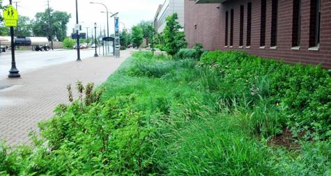
than street trees, including low-maintenance parkway plantings, bumpout plantings, raised planters, and permeable pavers, prioritized in Community Heart and Hub areas, would require a maintenance partner to ensure the plantings and infrastructure are maintained.
For additional information on recommended tree and plant species, refer to:
- Street Trees: Chicago Urban Tree Planting List 2012
- Infiltration Planters: Rain Gardens, Native Plant List Illinois Extension; Rain Garden Requirements and Plant Lists , Illinois Department of Natural Resources
- Roadway Planting: Chicago Department of Transportation, Roadway Plant List
CHICAGO LANDSCAPE ORDINANCE
According to the Chicago Landscape Ordinance, street trees are required along sidewalks wider than nine feet, and must adhere to the City of Chicago diversity policy. Refer to the Chicago Landscape Ordinance for more information.
Tree placement should frame views to building entrances, avoiding direct obstruction of building doors and signage where able, and need to take into consideration existing underground utilities and infrastructure.
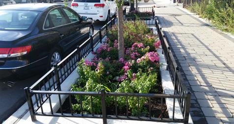
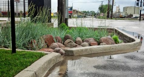

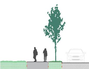
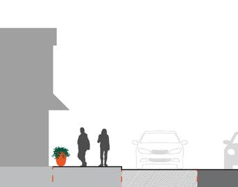
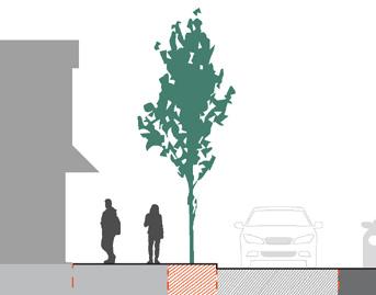
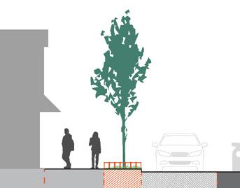
The use of native plants can increase habitat and visual interest in the neighborhood.
For narrower sidewalks where trees are unable to be planted, freestanding planters can be introduced to enhance the streetscape and add visual interest to storefronts.
For sidewalks between nine and 12’, trees can be planted in tree grates.
For sidewalks over 12’, trees can be planted in a curbed parkway
Figure 43. ROW less than nine feet with no trees
Figure 44. Commercial ROW between nine and 12 feet with trees in grates
Figure 45. Commercial ROW over 12 feet with trees in curbed parkway planters
planter.
Figure 42. Residential ROW with trees in sodded parkway planters
Figure 41. Landscape typologies along Harlem Avenue
Figure 38. Native plant rain garden along the Cermak/Blue Island Streetscape (Source: CDOT)
Figure 39. Curbed parkway planter (Source: CDOT) Figure 40. Bumpout infiltration planter (Source: CDOT)
CORRIDOR IDENTITY AND BRANDING
The brand identity for Harlem Avenue should speak to the people and culture of Harlem Avenue in a way that honors the present and future residents of this neighborhood and their collective values of community, celebration, and connection while paying homage to the corridor’s history. The brand will be implemented on all signage, wayfinding, and marketing materials.
The Harlem Avenue brand identity drew inspiration from mid-century Italian graphic designers who have put contemporary twists on traditional forms mixed with the values of connection, celebration, and community. The color palette initially inspired by the Italian red, green, and white, expanded to include Chicago blues and other colors to represent the diverse population found along Harlem Avenue today.
The brand is inspired by the Italian designer Massimo Vignelli. It draws attention to the corridors geography, location and the communities that it passes through. The vertical line represents the corridor going North to South, while the horizontal lines represent the boundaries, Irving Park Road to the north, and Grand Avenue to the south, and the Community Heart and Community Hubs.
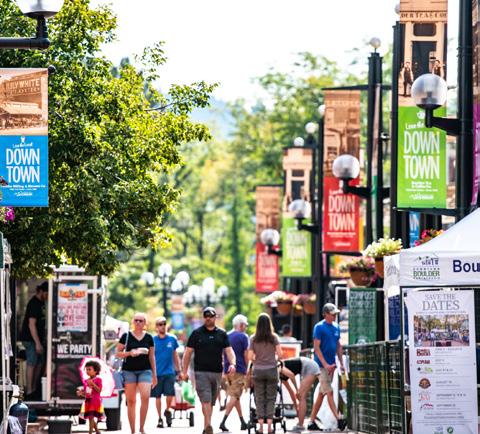
To study the potential of the brand, light pole banners were developed which showcase different color options. The Working Group identified the desire to use the Little Italy themed banner at the Community Heart and Community Hubs, while the other color options could be used outside of those areas. The community area name at the bottom of the banner can help visitors identify where they are along the corridor.
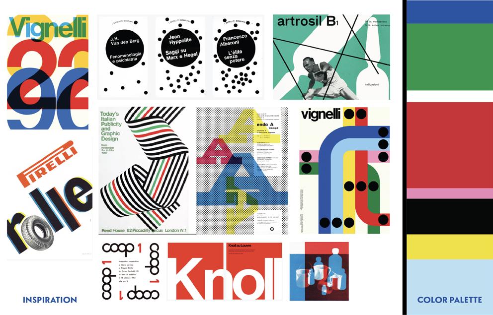
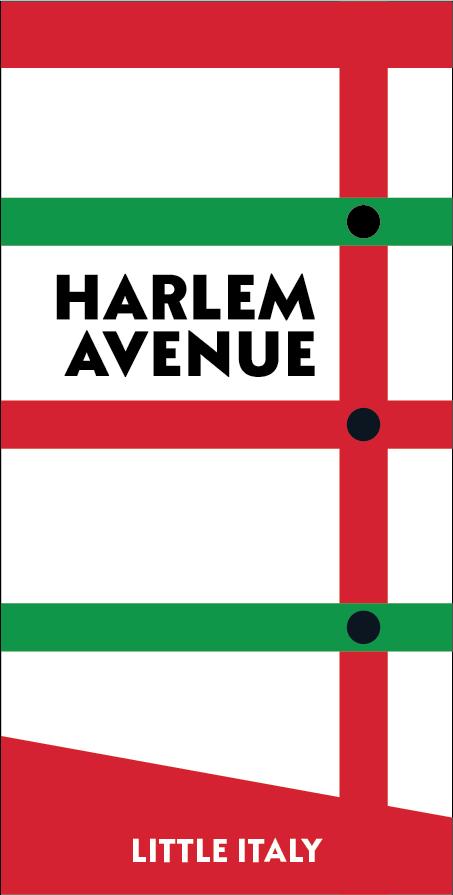
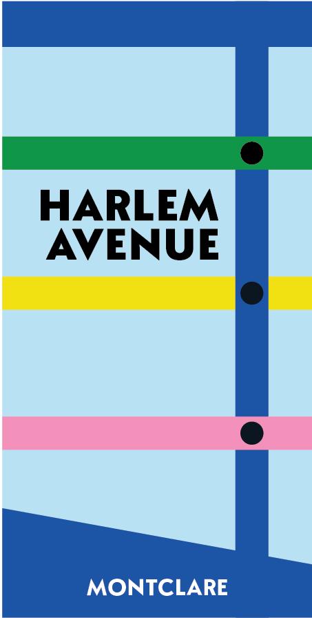
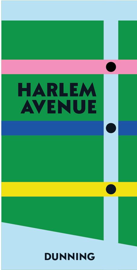
Figure 46. Harlem Avenue Corridor branding fonts, inspiration and color palette
Figure 47. Harlem Avenue Corridor branded light pole banner options
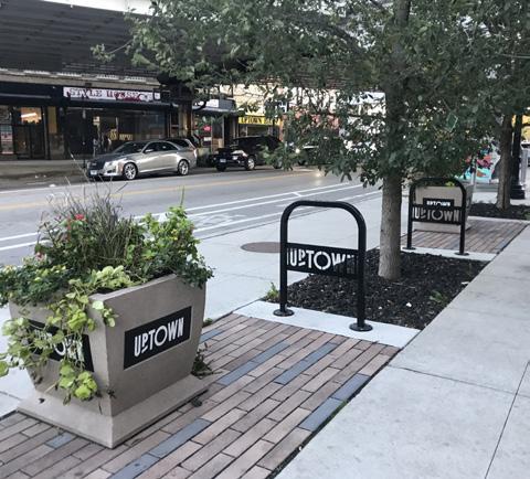
Within the public right-of-way, there are opportunities for the community to celebrate Harlem Avenue and showcase the brand identity of the corridor. The opportunities within the public right-of-way include:
- Raised planters
- Signage and Wayfinding
- Sidewalk art and specialty paving
- Enhanced crosswalk materials
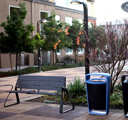
- Street furnishings like bike racks, waste and recycling receptacles, and public benches
RIGHT OF WAY
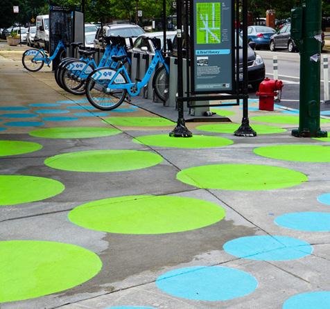
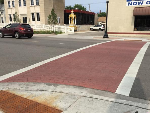
Business owners can also contribute to the identity of Harlem Avenue by including references to the Harlem Avenue brand on their private buildings and storefronts. Some ideas for brand opportunities include:
- Freestanding planters
- Facade, awnings, and window signage
- Movable furnishings
- Fencing and barriers
- Seasonal displays
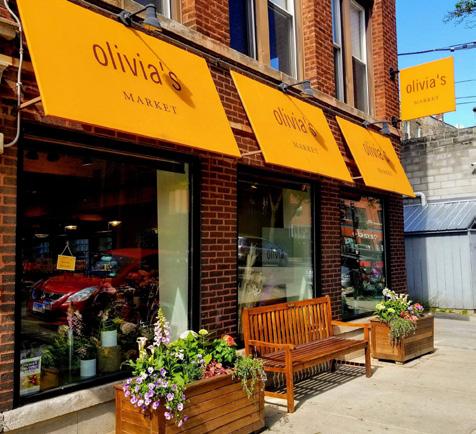
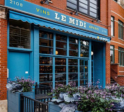
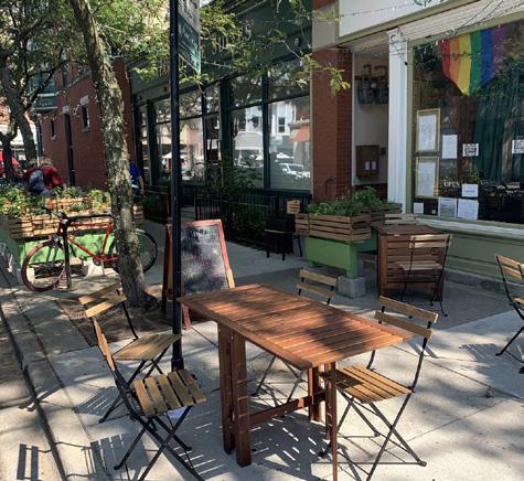
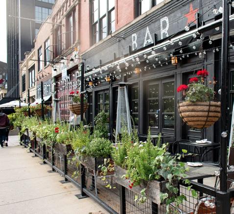
Figure 48. Raised planters
Figure 53. Freestanding planters (Source: Olivia’s Market)
Figure 50. Furnishings (Source: Landscape Forms)
Figure 54. Movable furnishings (Source: Eater Chicago)
Figure 49. Signage and wayfinding (Source: Conde Nast)
Figure 55. Facades, awnings, and window signage (Source: Le Midi Wine)
Figure 51. Sidewalk art/specialty paving
Figure 52. Enhanced crosswalk materialsThermoplastic (Source: IDOT)
Figure 56. Fencing and barriers (Source: Luxury | Living)
To effectively guide visitors and residents to Harlem Avenue, a comprehensive brand identity signage and wayfinding plan should be implemented. This study should incorporate a combination of street wayfinding signs, gateway identifiers, mural opportunities, light pole banners, bus shelter signs, and seasonal displays.
Street Wayfinding Signs
To ensure easy navigation to Harlem Avenue, street wayfinding signs should be installed on the streets perpendicular to the corridor as one approaches the intersection. These signs would provide clear directions to Harlem Avenue from Irving Park Road, Addison Street, Belmont Avenue, Diversey Avenue, and Grand Avenue.
Gateway Identifier Structures
Once visitors arrive at Harlem Avenue, they should be greeted by clear and welcoming gateway identifier structures. These structures would serve as visual landmarks, signaling the entrance to the community’s Heart and Hubs. Two locations for gateway identifier structures are recommended: one located near the intersection of Harlem and Cornelia avenues and another near the intersection of Harlem and Schubert avenues. In addition to the structures, murals on the north or south faces of buildings will also reinforce the brand and identity of Harlem Avenue.
Banners on Light Poles and Bus Shelter Signage
Install banners on light poles and bus shelter signs along the entire twomile corridor. These banners would provide a sense of continuity and reinforce the unique character of the corridor.
Seasonal Displays
To further enhance the vibrancy of Harlem Avenue, seasonal displays can be incorporated into the community’s Heart and Hubs. These displays could include temporary installations, such as light displays or sculptures, that reflect the changing seasons and add a festive touch to the neighborhood.
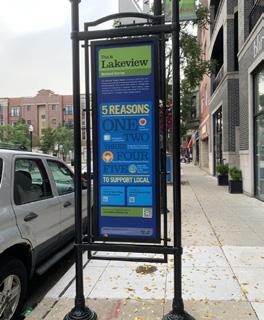
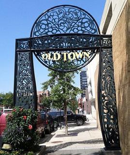
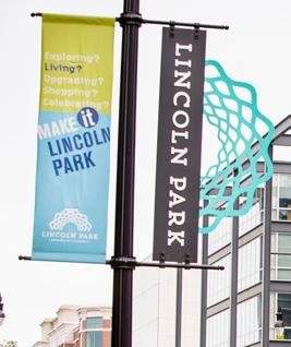
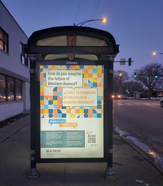

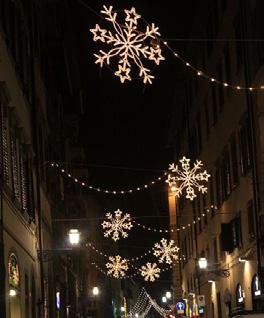

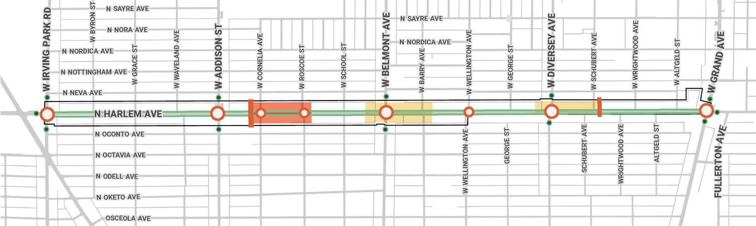
Figure 61. Seasonal displays at the Heart and Hubs (Source: Flickr)
Figure 59. Light pole banners (Source: CDOT)
Figure 60. Bus shelter wall panel for announcements, community communication, and events signage
Figure 57. Street wayfinding (Source: DPD)
Figure 58. Gateways (Source: Wikipedia)
Figure 62. Signage and wayfinding recommendations
COMMUNITY GATHERING
To foster a vibrant and welcoming public realm, three focus areas—the Community Heart and two Community Hubs — are proposed to serve as anchors for neighborhood activity, providing spaces for visitors, businesses, and residents to gather, connect, and celebrate.
COMMUNITY HEART
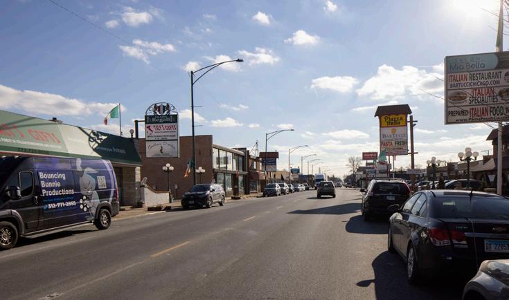
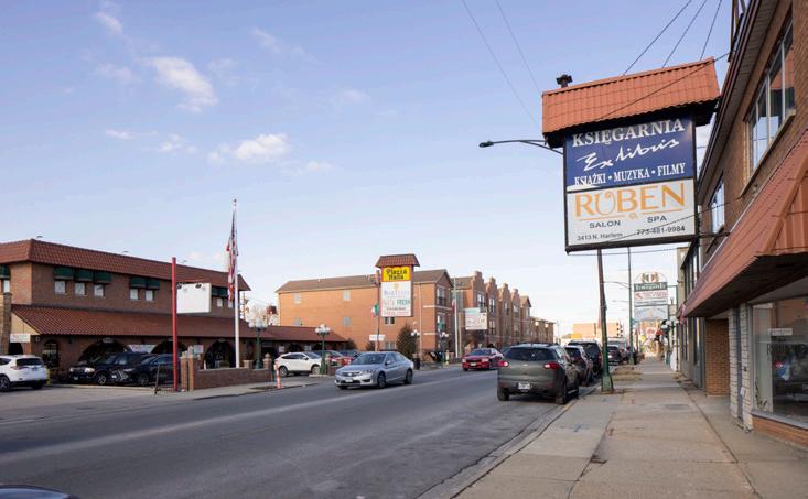
The main gathering area of the Harlem Avenue corridor is envisioned between Cornelia Avenue and Roscoe Street, a two-block stretch envisioned as the neighborhood’s Community Heart. This section of Harlem Avenue currently houses a diverse range of businesses and institutional uses, including Piazza Italia with Pasta Fresh, Bartucci Homemade Italian Food, Salon Mia Bella, Palazzo Regali with La Bomboniera and Galleria D’Arte, the future National Italian American Sports Hall of Fame, Iglesia Casa del Dios Viviente, and Our Saviour Lutheran School that attract many visitors to the area, but currently lacks adequate public spaces and green infrastructure.
To transform this area into a Community Heart, design recommendations have been proposed and outlined on the following pages.
In addition, the Working Group has observed concerns about pedestrian safety at the Community Heart due to high volumes of vehicular traffic and the number of pedestrians crossing to access businesses. The future vision proposes additional public space for event activation to occur around the National Italian American Sports Hall of Fame and Piazza Italia, providing the opportunity for an increase in pedestrian traffic. The Visioning Study has identified the desire for IDOT to study this area for a midblock crossing between these spaces to help alleviate pedestrian crossing concerns and allow for safer crossing for pedestrians.
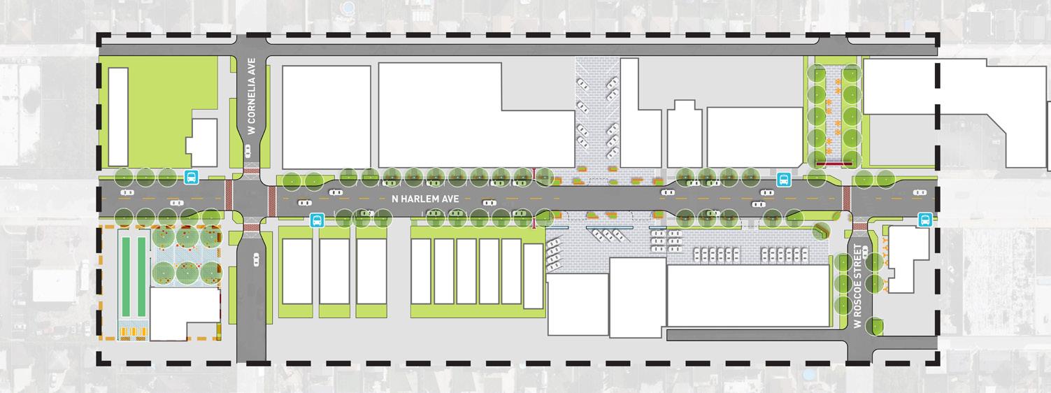
For small and medium events, users can activate the bumpouts, the community plaza at the closed Roscoe Street, or temporarily activate private parking lots at the National Italian American Sports Hall of Fame and Piazza Italia, and the open space at the opportunity site on the northwest corner of Cornelia and Harlem avenues in collaboration
with the private property and business owners. For large events, the community can coordinate with IDOT, CDOT, and CTA to temporarily close Harlem Avenue from Cornelia to Roscoe and add movable market tents, planters, and tables and chairs.
Note: These visions are for illustrative purposes only and would require further analysis, community engagement, cooperation with property owners, funding allocation, design, and engineering before future improvements could be implemented.
*Plan is depicting Option B: Pedestrian Arch Gateway. For gateway options refer to pages 50 -51.
Figure 63. Looking south on Harlem Avenue from Cornelia Avenue
Figure 64. Looking north on Harlem Avenue from Roscoe Street
Figure 65. Community Heart plan
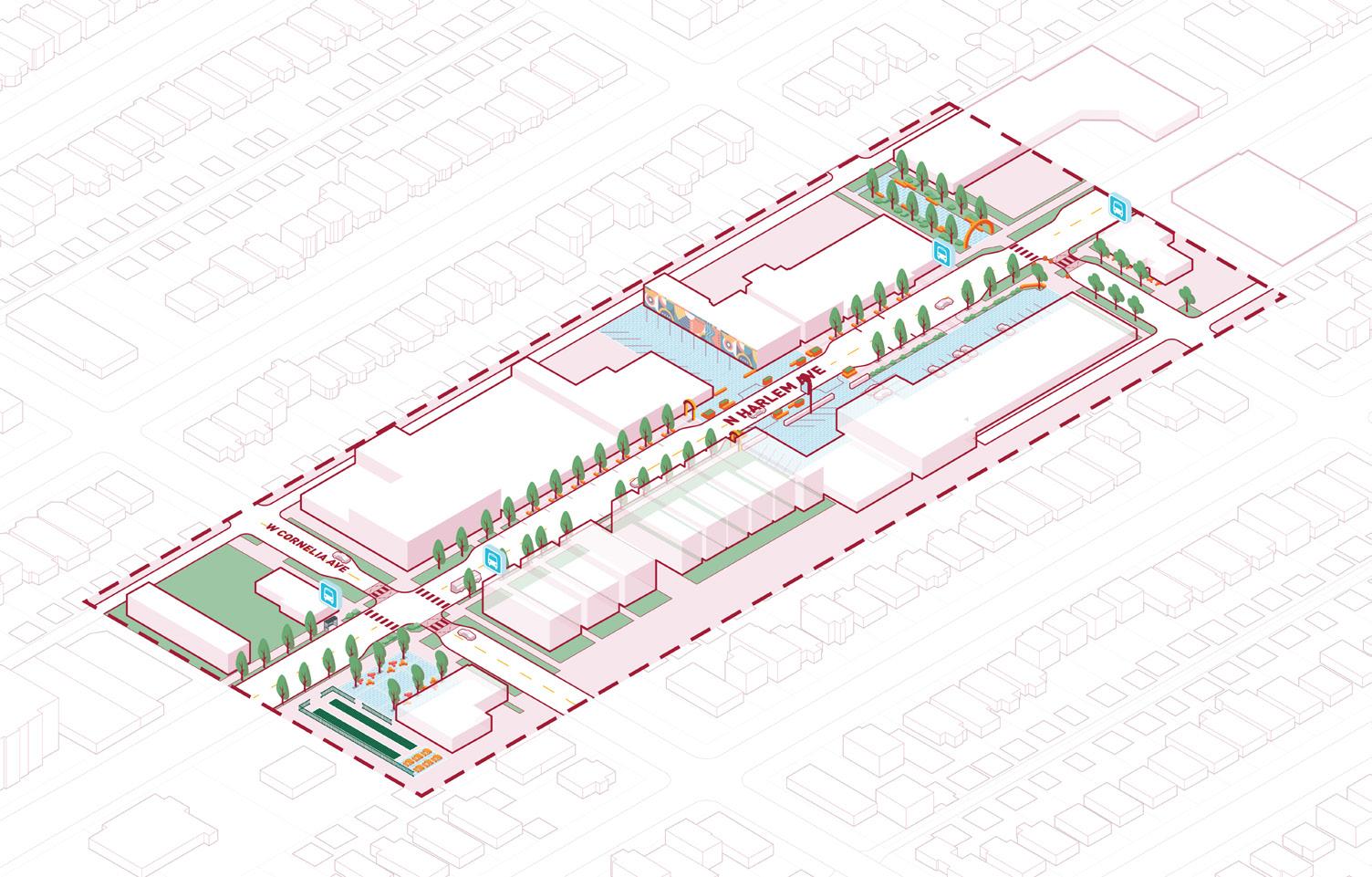
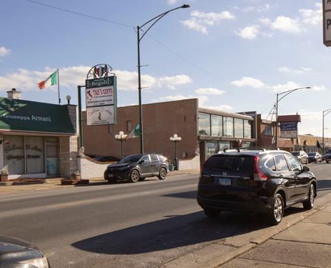
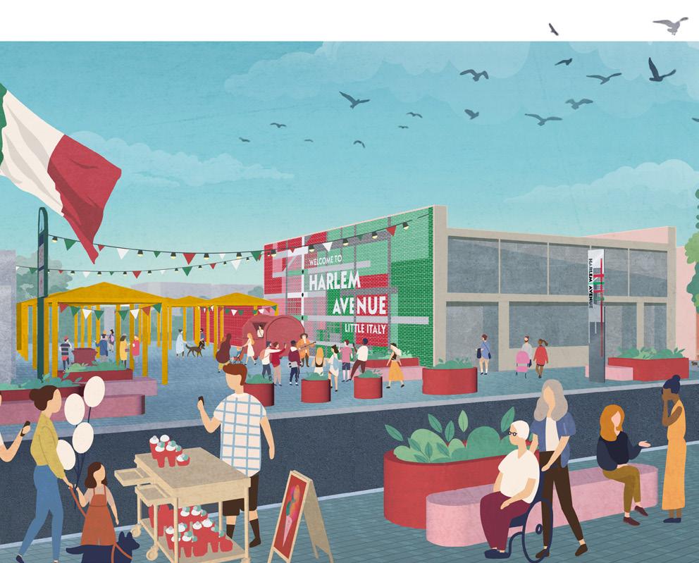
Figure 68. Community Heart perspective
Figure 67. Community Heart existing condition
COMMUNITY HUB 1: WEST BELMONT AVENUE
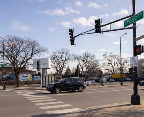
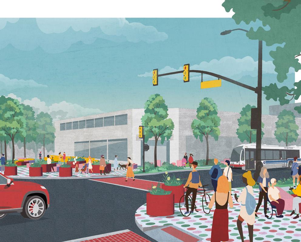
The first Community Hub location is proposed along Harlem Avenue, from north of Belmont Avenue to south of Barry Avenue.
The design recommendations outlined in the following pages will enhance the pedestrian experience, improve transit, and create opportunities for public gatherings along the corridor.
In addition, the Visioning Study has identified the desire for a feasibility study of a future bike lane along Belmont Avenue to connect the Belmont bike lane proposed in CDOT’s 2023 Chicago Cycling Strategy.
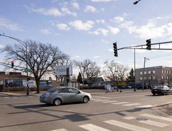
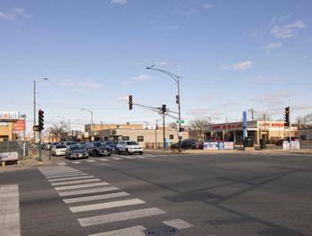
Note: These visions are for illustrative purposes only and would require further analysis, community engagement, cooperation with property owners, funding allocation, design, and engineering before future improvements could be implemented.
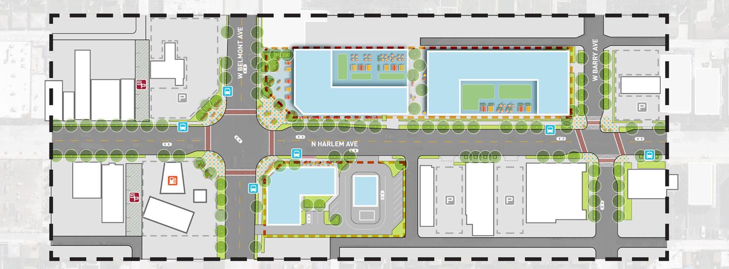
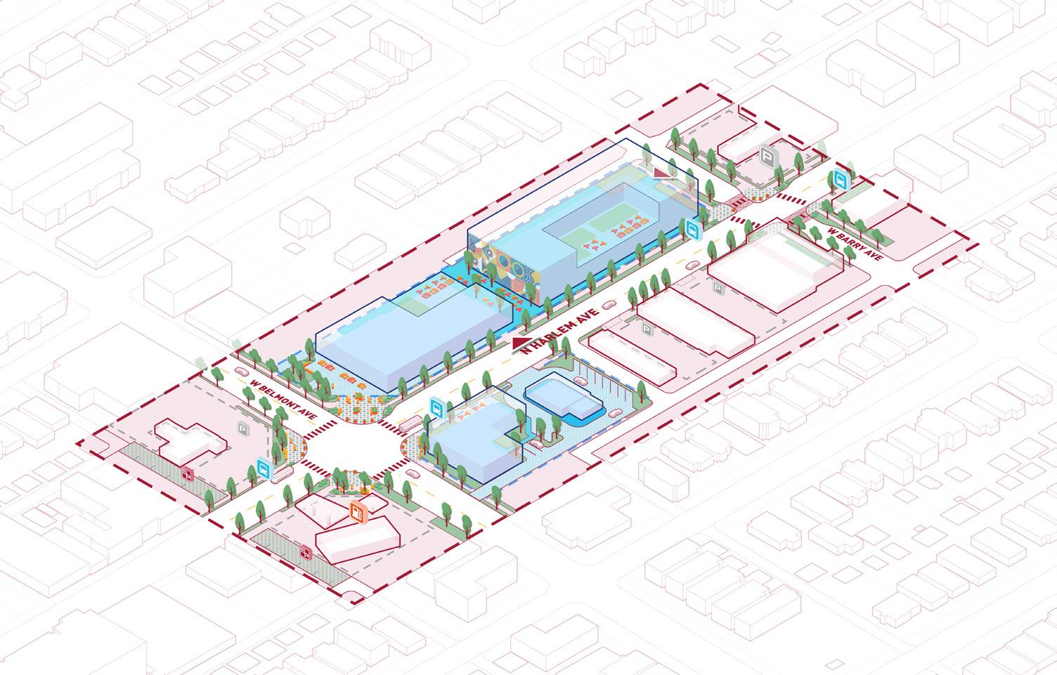
Figure 72. Community Hub 1 - Belmont axon
Figure 69. Community Hub 1 - Belmont plan
Riviera Foods
COMMUNITY HUB 2: WEST DIVERSEY AVENUE
The second Community Hub location is proposed along Harlem Avenue, from north of Diversey Avenue to south of Schubert Avenue.
The design recommendations outlined on the following pages will enhance the pedestrian experience, improve transit, and create opportunities for public gatherings along the corridor.
The future vision proposes the opportunity to activate open space on private property for community events in collaboration with private property and business owners. The Visioning study has identified the desire for IDOT to study this area for an additional crosswalk at the north side of Schubert Avenue to help alleviate pedestrian crossing concerns and allow for safer crossing for pedestrians.
to bus turnaround
(e.g. Resurfacing, lighting, accessibility, etc.)
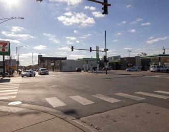
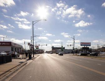
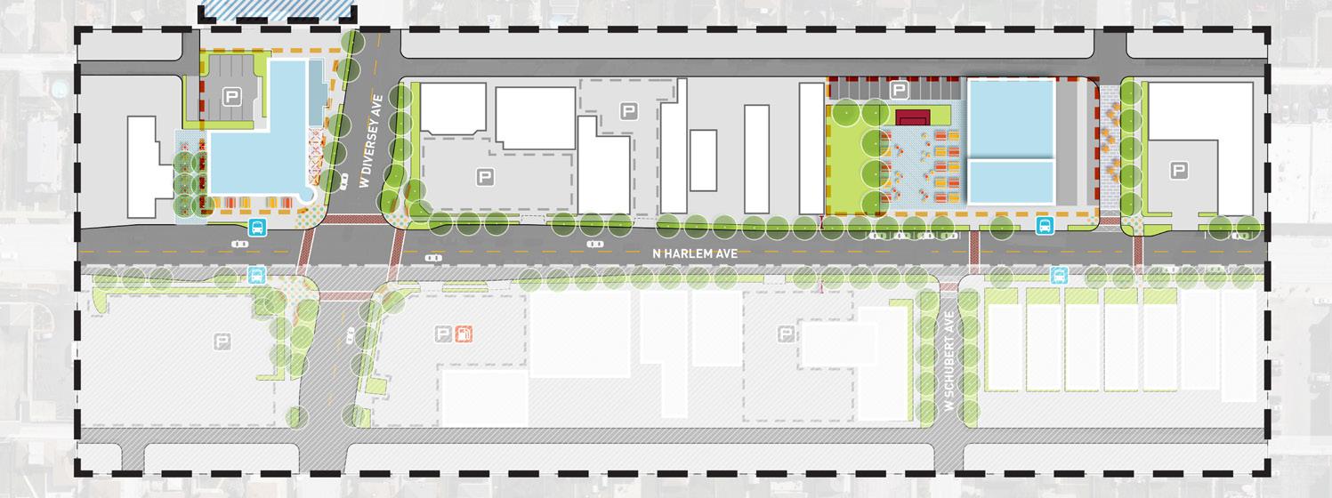
Figure 75. Community Hub 2 - Diversey plan
Figure 74. Community Hub 1 - Belmont perspective
Figure 73. Community Hub 1 - Belmont Avenue existing condition
Figure 76. Looking south on Harlem Avenue from Diversey Avenue
Figure 77. Looking north on Harlem Avenue from Diversey Avenue
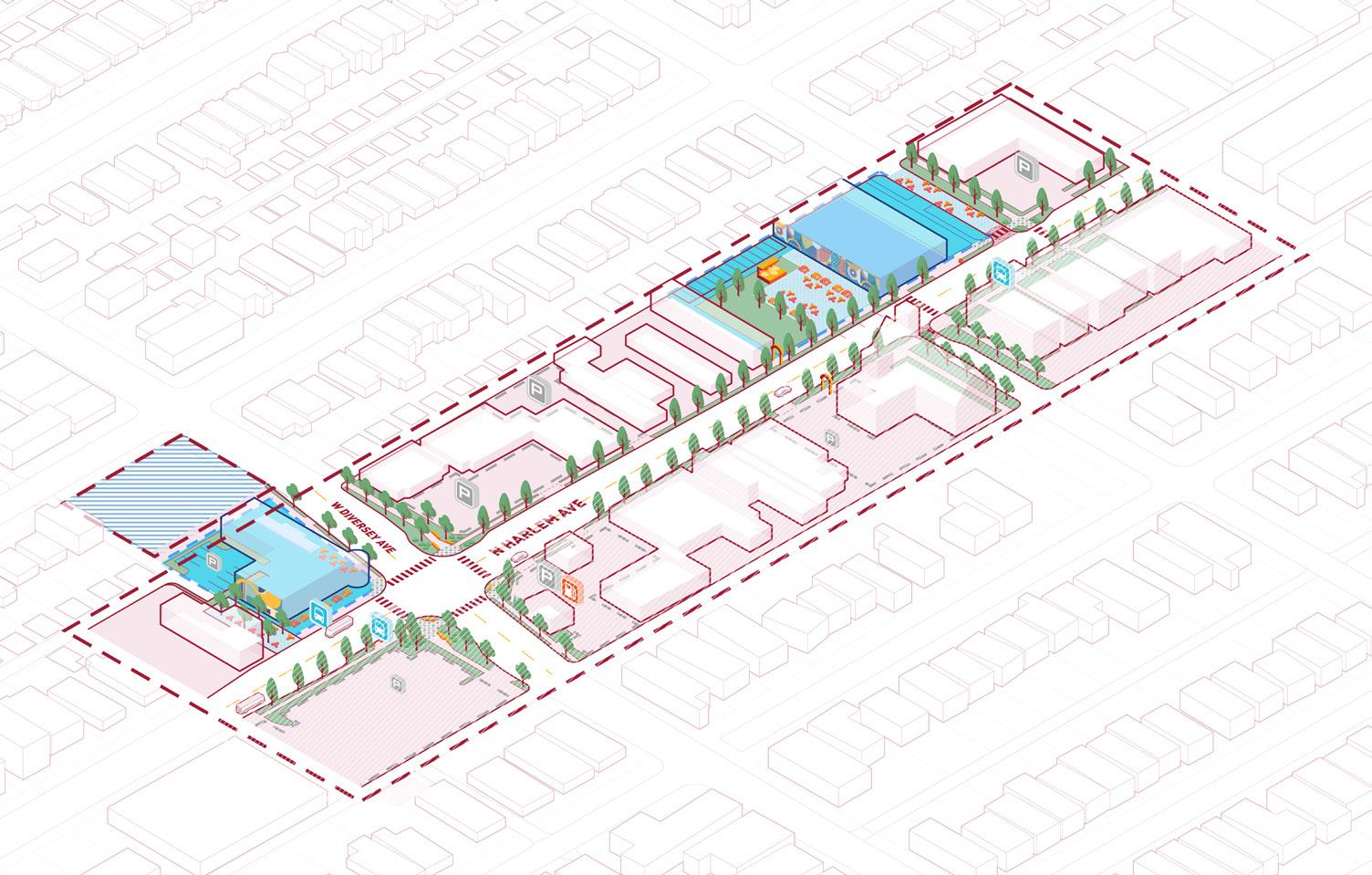
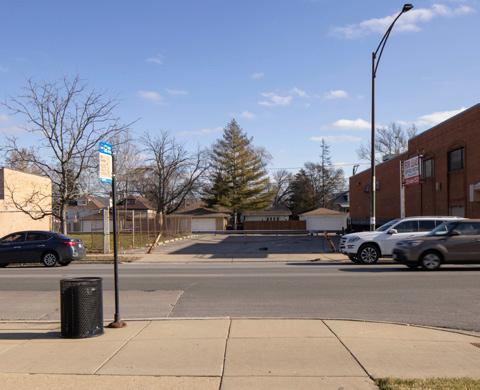
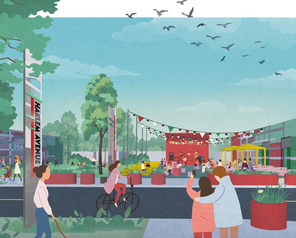
Figure 80. Community Hub 2 - Temporary activation
Figure 79. Community Hub 2 - Existing condition
Figure 78. Community Hub 2 - Diversey Avenue axon
GATEWAY VISIONS
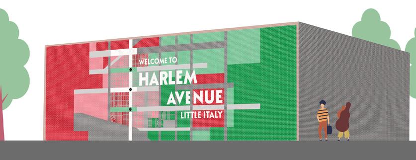
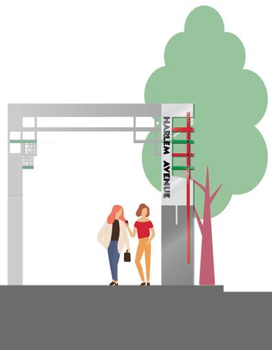
Creating a distinctive identity for the Harlem Avenue corridor involves establishing gateway identifiers that draw attention to key areas like business centers and areas for community gatherings, and signifying the entrances to the Community’s Heart and Hubs. These identifiers should be visually compelling, visible from a distance, and possess landmark quality. The Visioning study includes near term and longer term design recommendations for gateways. For the near term solution, murals are recommended to be implemented on walls of private property, with approval and coordination with property owners. For the longer term solution, either vertical gateways or pedestrian arch gateways are recommended to be implemented within the ROW within the pedestrian space. These are longer term solutions as a gateway identifier would require coordination and approval from IDOT and CDOT. The Working Groups preference is the pedestrian arch gateway. Feasibility of the gateway locations and design shall be completed in a future design study
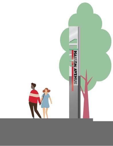
There are two options for the north and south gateways locations: North Gateway
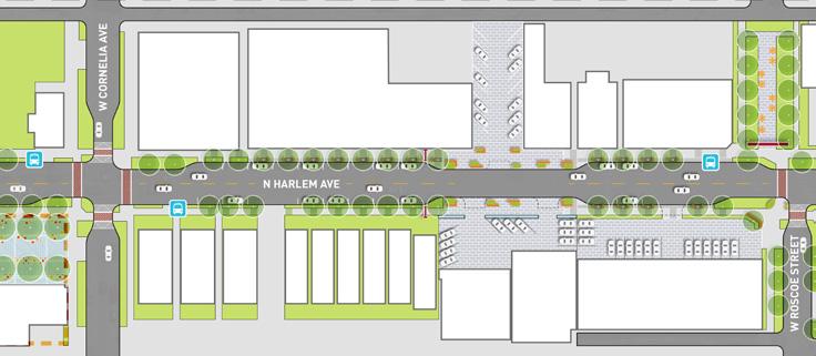
Option 1 - Placing two vertical gateways midblock between Cornelia and Roscoe avenues at the south side of the midblock bumpout. Providing a mural on the north side of the National Italian American Sports Hall of Fame building.
Option 2 - Placing two pedestrian arch gateways midblock between Cornelia and Roscoe avenues at the north side of the midblock bumpout. Providing a mural on the north side of the National Italian American Sports Hall of Fame building.
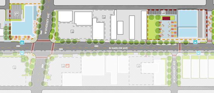
Option 1 - Placing two vertical gateways on the north side of Schubert and Harlem avenues. Providing a mural on the north side of the M C Foods building, and on the south side of the Harlem Cafe building.
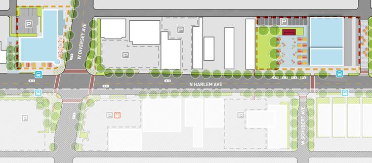
Option 2 - Placing two pedestrian arch gateways south of the Harlem Cafe building. Providing a mural on the north side of the M C Foods building, and on the south side of the Harlem Cafe building.
Figure 81. Near term: Murals
Figure
South Gateway
EXISTING BUILDING RECOMMENDATIONS
The built environment of Harlem Avenue, particularly the street-facing facades of the commercial buildings, are the heart and soul of the commercial corridor playing a formative role in shaping its sense of place.
To support Harlem Avenue’s commercial character, the following design strategies guide rehabilitation work on the exteriors of existing buildings.
MAINTAIN AND REPAIR EXISTING MASONRY MATERIALS AT STREETFACING/PRIMARY FACADES
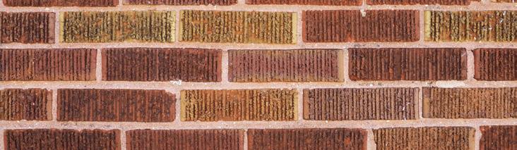
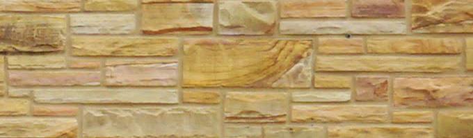
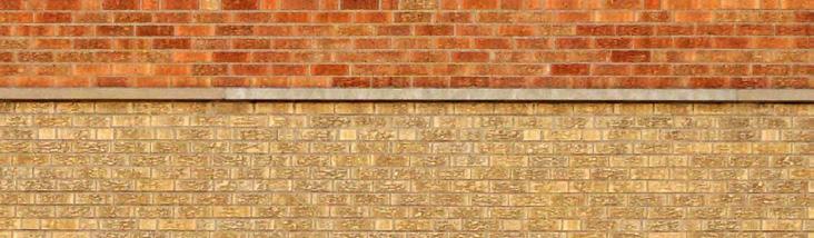
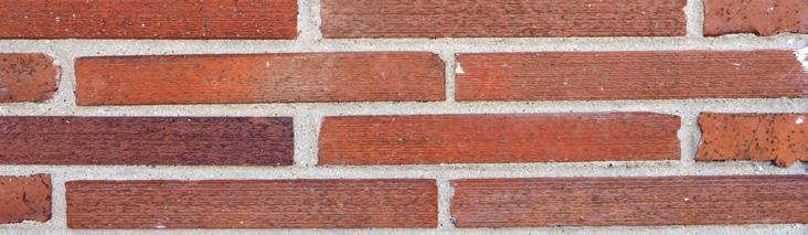
A distinctive architectural feature of Harlem Avenue’s built environment is the use of textured and/or polychromatic masonry (e.g., split face Roman brick, Lannon stone, Bedford limestone). Consideration should be given to the retention and repair of existing masonry when possible. Long-term maintenance of existing masonry should focus on repainting, as needed, to match the existing in joint width, color, tooling, profile, and mortar composition. Repairs should also include cleaning masonry to remove retardant deterioration (soiling materials that are potentially harmful to the masonry), to provide a clean surface for repairs, for masonry inspection, or to improve appearance. Cleaning masonry should be done using the most gentle effective means by avoiding the use of harsh acids or high-pressure water washing.
2
MAINTAIN THE EXISTING STOREFRONT CONFIGURATION AND OVERALL DESIGN
Many of the commercial buildings along Harlem Avenue retain their original mid-20th century metal storefronts. Key components of the storefronts include lower masonry knee walls and expansive, clear glass display windows which angle inward to meet a recessed storefront entrance. Consider rehabilitating existing storefronts by refinishing metal components and/or replacing/repairing glazing, as needed, or replace existing storefronts to match. It is recommended to retain the large display window configurations seen in the corridor to increase visibility and create a more welcoming environment for customers and visitors. Additionally, when rehabilitating or replacing an existing storefront consider retaining the existing configuration, specifically how many storefronts angle inward toward a recessed entrance. The setback created by the angled storefront can be used to provide outdoor dining or cafe seating or enhance the public realm through landscape planters.
CONSIDER THE INSTALLATION OF BUILDING LIGHTING
Building lighting is a contributing and essential component to the built environment and public realm of Harlem Avenue. It can also improve security, elevate visibility, and enhance the architectural features of a building. Specific recommendations for lighting at buildings includes:
- Consider lighting that maximizes energy efficiency in new and replacement installations.
- New lighting is encouraged to be aesthetically integrated into the architectural design of the building while avoiding exterior surface-mounted transformer boxes, raceways, and conduit.
- Ground-level and/or first-floor exterior lighting should enhance safety and security while adding a pedestrian-scale element to the public realm character.
- Consider concealed, minimal lighting targeted to illuminate architectural features, storefronts, and signs. Avoid lighting that will detract from the character of a building, such as industrial wall pack lights, unshielded lights, lamps, or floodlights that produce glare and light trespass, or animated/flashing lighting, except holiday lighting.
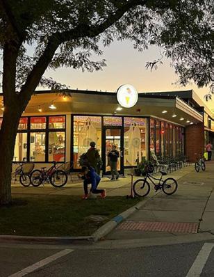
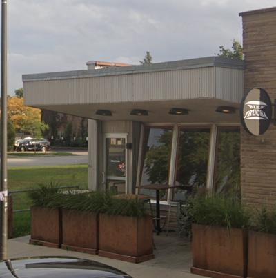
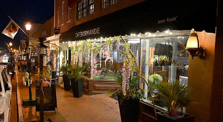
Figure 84. Examples of polychromatic and textured masonry along Harlem Avenue.
Figure 85. Examples of rehabilitated mid-twentieth century commercial buildings. Each rehabilitation maintained the character-defining features while modernizing and enhancing the storefront. (Source: Triple Scoop’d (left), Google Streetview (right))
Figure 86. Building lighting example (Source: Capital Gazette)
PRESERVE AND ADAPTIVELY REUSE EXISTING AND HISTORIC SIGNAGE
Signage in the corridor is a significant component of Harlem Avenue’s sense of place. Signage in the corridor includes distinctive projecting signs, awnings signage, cabinet signage, channel letters, wall signs, and storefront window signage. Specific recommendations include:
- The Vintage Sign Ordinance, Sections 17-15-0640 and 1715-0650 of the Chicago Zoning Ordinance, was adopted in 2023 and provides a pathway for legalizing and maintaining nonconforming signs that have remained in their existing location for at least 30 consecutive years, including abandoned nonconforming signs, that represent important elements of the City’s heritage and enhance the character of the community. Reuse of historic signs may not be permitted in all cases, and any such reuse must adhere strictly to the City’s Sign Ordinance.
- If a building or business has changed hands, historic signs associated with former enterprises in the building should be considered for reuse. There are several examples of a reused sign along Harlem Avenue. The advertising value of an approved vintage sign can be immense, especially if the sign serves as a distinguishing feature of the community and the building’s history. If the historic sign is retained, it will preferably be left in its existing location, though it may be necessary to move the sign elsewhere on the exterior of the building to accommodate a new one. An existing sign may be modified for use with a new business, but this may not be possible without destroying essential features.
- If a historic sign is retained and adaptively reused, maintenance is essential for its long-term preservation and should include cyclical inspections such as burnt-out light bulbs, loose, weakened, or missing anchors, water damage, deterioration of electrical connections, and pest removal (e.g., birds or insects).
- For buildings that do not have existing or historic signage, utilize illuminated or unilluminated hanging signs, blade signs, or banner signs to maintain and contribute to the defining character of Harlem Avenue.
- Projecting a sign from the building wall should be attuned to the mass and scale of the building to which it is attached, and respect the size, scale, and design/character-defining features of the building. Projecting signs will be subjective to additional requirements under sec. 17-12-1005-F Projecting Signs of the Chicago Zoning Ordinance.
- Ensure new signs do not damage any historic fabric. For example, fittings should penetrate mortar joints rather than masonry.
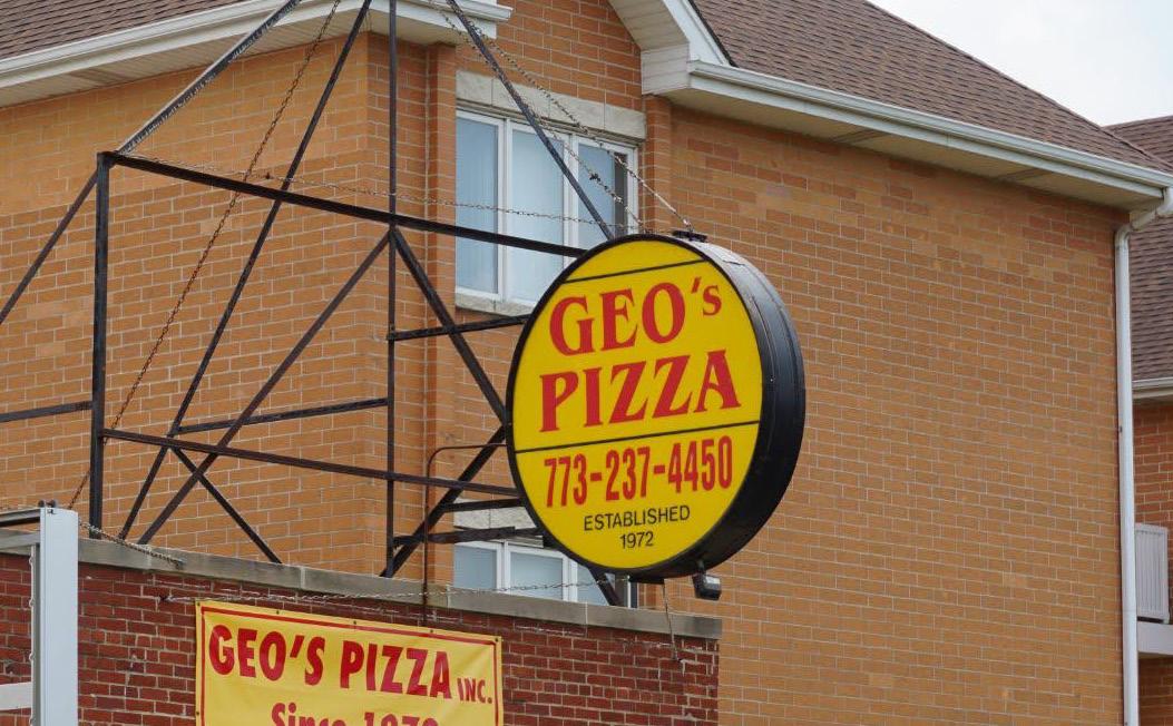
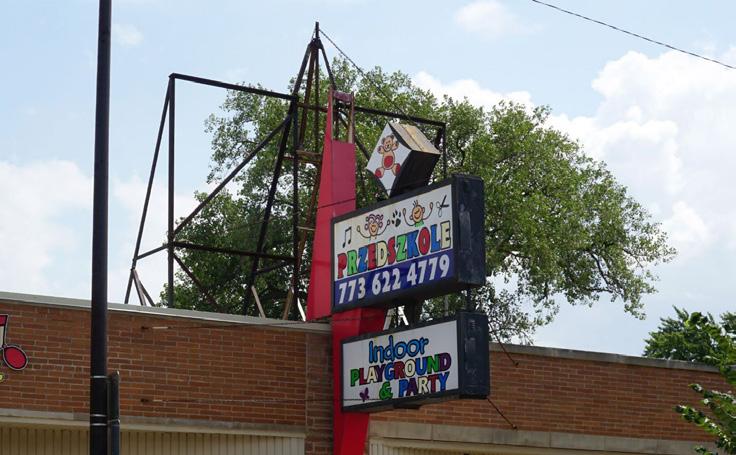
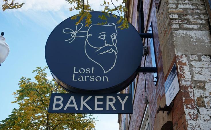
Figure 87. Example of reused signage on Harlem Avenue
Figure 89. Example of appropriate new signage within a commercial corridor
Figure 88. Example of reused signage on Harlem Avenue
IMPLEMENTATION FRAMEWORK
This section provides a roadmap for future implementation of the Public Improvements, the Community Heart, and the two Community Hubs visions. Recommendations are provided for long-term and near-term implementation based on the greatest needs heard from the working group and describes recommended future partners, opinion of probable costs, and potential funding sources from the local, state, and federal levels.
One of the most common funding mechanisms for commercial corridor improvements or enhancements in Chicago are Special Service Areas (SSAs). Alternatively, enabling legislation to establish a Business Improvement District is expected to be voted on by the Illinois legislature in 2024. To fund and maintain many of the ideas in this Visioning Study, the local business association and property owners may consider establishing a Special Service Area, Business Improvement District, or a similar Business Service Organization (BSO).
Business and community groups play a crucial role in implementing the recommendations outlined in this study. Serving as collective advocates, they are able to consolidate interests and voice ideas or concerns to decision-makers, ensuring the needs of local businesses and residents are prioritized. By pooling resources, these groups can accumulate capital for significant projects and champion initiatives beyond the reach of individual businesses or property owners, and are central in coordinating efforts, engaging with the community, managing projects, and overseeing project execution. Their expertise and commitment to economic development contribute to a vibrant, thriving commercial corridor, benefiting both businesses and the surrounding community.
SSAs offer a range of benefits, serving as localized tax districts that fund expanded services and programs within a specific area. These areas enjoy improved public infrastructure, beautification, and economic development, with funds allocated for public maintenance, security, business retention, marketing initiatives, events, and more. Successful SSAs demonstrate visible improvements, such as street murals and cleaner public spaces, contributing to the overall vitality and attractiveness of designated areas. Additionally, SSAs may leverage their influence to secure grants and resources, further enhancing the economic prosperity of the community. When establishing an SSA, it is important to have a strong and organized association with the capacity to administer the SSA, professional expertise from a trusted party familiar with the SSA process, and clear messaging to participating property owners that ensure close collaboration, agreed upon boundaries and tax levy, and understanding that the additional tax paid by participating property owners will all go back into their community for shared benefits.
At the time of this writing, DPD is advocating for the establishment of Business Improvement District (BID) legislation at the state level. While similar to SSAs, BIDs can offer greater flexibility in areas where SSAs may be less feasible. If BIDs legislation is approved at the state and city levels, it is recommended to evaluate which program is better suited for the Harlem Avenue corridor.
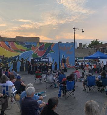
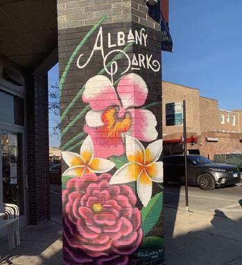
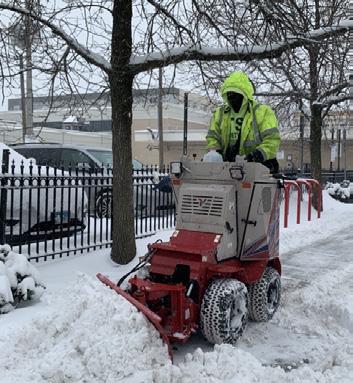
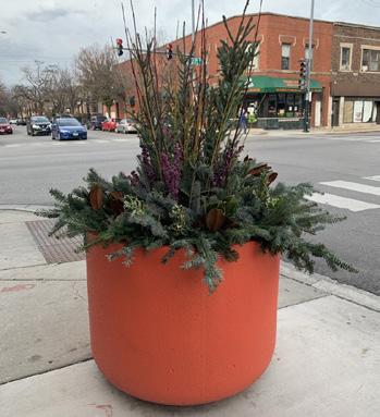
Figure 90. SSA benefit example: special events (Source: DPD)
Figure 92. SSA benefit example: sidewalk snow removal (Source: DPD)
Figure 91. SSA benefit example: murals (Source: DPD)
Figure 93. SSA benefit example: freestanding planters (Source: DPD)
Seasonal displays
OVERALL CORRIDOR: SIGNAGE AND WAYFINDING
Install seasonal displays at the Community Heart and Hubs. These displays could include temporary holiday installations, light displays, or art that reflect the changing seasons.
Light pole banners
Install vinyl banners on light poles along the entire two-mile corridor. These banners provide a sense of continuity and reinforce the unique character of the Corridor.
Identify community desired locations where metal banners can be added to light poles.
OVERALL CORRIDOR: SIGNAGE AND WAYFINDING (CONT.)
Bus shelters
Coordinate the use of bus shelter wall panels for events, community announcements, and wayfinding. Community groups, business service organizations*, chambers of commerce, and non-city entities can request to post signage on bus shelter wall panels as long as they make the request directly with JCDecaux at least three weeks before the desired posting date. For city messaging, requests go through the Finance Department.
Install new bus shelter styles and coordinate Corridor branding into the final design.
Street wayfinding
Overall corridor signage and wayfinding recommendations continue on next page...
Gateway Identifier Structures
Finalize corridor branding
Further study and analysis will be required to create designs for Corridor branded site furnishings and elements prior to purchase and placement.
Install street wayfinding signs on the streets perpendicular to the corridor to help individuals navigate to Harlem Avenue. These signs could provide clear directions and distance to Harlem Avenue from major streets.
Install gateway identifier locations along Harlem Avenue. Refer to the Community Heart and Hub sections for locations. These identifiers would serve as visual landmarks, clearly signaling the entrance to the Heart and Hubs of the Corridor.
= Recommended future partner organization
* = Pending approval of SSA or potential BID by Harlem Avenue community
Light poles
OVERALL CORRIDOR: CIRCULATION AND SAFETY
New light poles will be implemented from Rosco to Grace per request from Ald. Sposato. Ald. Sposato has requested new light poles from Grace to Irving Park Road. Request new light poles from Roscoe south to Grand. New light poles to allow for outlets, attachments for metal and vinyl banners, and pedestrian lighting.
Install new light poles on the west side of Harlem Avenue to create a consistently lit Corridor that will increase safety and pedestrian experience. New light poles to allow for outlets, attachments for metal and vinyl banners, and pedestrian lighting.
ROW cross section
Local intersection improvements
Major intersection improvements
Refer to cross sections on pages 28 - 29 for typical future vision widths of travel and parking lanes, bumpouts, sidewalks, and planting areas. A traffic engineering study will be required for any future proposed bumpouts, medians, lane changes, and other updates that fall within the public ROW and affect vehicular traffic flow.
Where feasible (no existing driveway conflicts), relocate existing bus stops to the far side of intersections. Install bumpouts at the near side of intersections to allow for a safer and shorter crossing and a better pedestrian experience. Any planted bumpouts will require a maintenance partner. All proposed bumpout widths will need to be determined based on the autoturn analysis of a firetruck and a WB-65 design vehicle.
Where feasible (no existing driveway conflicts), relocate existing bus stops to the far side of intersections and add bus shelters if sidewalk widths permit. Install bumpouts at the near side of intersections to allow for a safer and shorter crossing and a better pedestrian experience. Any planted bumpouts will require a maintenance partner. All proposed bumpout widths will need to be determined based on the autoturn analysis of a firetruck and a WB-65 design vehicle.
Enhance crosswalk materiality
CORRIDOR: CIRCULATION AND
Any citizen can make a 311 request for tree planting as long as there is an empty tree grate or parkway space available.
Street trees and planting
corridor circulation and safety recommendations continue on next page...
Freestanding planters
At narrow commercial parkways in the Corridor, where decreasing sidewalk widths to install parkway planting areas is not feasible, freestanding planters can be placed directly in front of businesses or storefronts. This creates a better curb appeal and pedestrian experience. Freestanding planters require a maintenance partner, such as a business service organization*, or can be provided and maintained by the business or storefront. Review and approval by CDOT is required to place any freestanding planters within the public ROW.
Install raised crosswalks parallel to Harlem Avenue at all cross streets except for major intersections. Raised crosswalks promote pedestrian safety and slow down vehicular traffic, increasing visibility.
Implement high-visibility crosswalk materials to create strong visual cues at crossings. This will promote a safer experience for the pedestrian and cohesiveness throughout the entire Corridor. All proposed materials will need to be reviewed and approved by IDOT and CDOT.
Refer to pages 28 - 33 for future visions of parkway planting along the Harlem Avenue Corridor. All proposed street tree and parkway planting will need to comply with the requirements of the Chicago Landscape Ordinance. Apart from street trees, any planting will require a maintenance partner.
Raised crosswalks
Install a Corridor gateway identifier
COMMUNITY HEART
Create a community plaza
Study feasibility of midblock crossing
Convert vacant lot to public open space
Activate the vacant parcel near the northwest corner of Cornelia and Harlem avenues with seating areas and bocce ball courts.
Install a gateway identifier between Cornelia Avenue and Roscoe Street that clearly signifies entry into the Harlem Avenue Corridor from the north.
Close Roscoe Street to vehicular traffic from Harlem Avenue to the alley half a block east and create a permanent public plaza with shade trees.
Create and support temporary events
Transform various parking lots within the Community Heart into spaces for temporary events and seasonal markets. This can further activate the area and provide opportunities for local commerce.
Study the feasibility of temporarily closing Harlem Avenue between Cornelia Avenue and Roscoe Street one to two times a year for larger events and festivals. To reroute buses, trucks, and vehicles, coordination with CDOT, IDOT, and CTA will be required.
Enhance existing parking lots
(1) Enhance the parking lot at the northwest corner of Cornelia and Harlem avenues with permeable paving and landscaping to create a plaza.
(2) Enhance existing parking lots at the Italian American Sports Hall of Fame and Piazza Italia Shopping Center with improved landscaping and permeable paving.
Any improvements within private property are to be maintained by private property owners or a business service organization*. Any permeable pavers, infiltration planters, planted bumpouts, or parkway planting (besides street trees) in the ROW will require a maintenance partner.
Study feasibility and design of a midblock crossing between Cornelia Avenue and Roscoe Street. Add bumpouts on both sides to shorten the crossing distance while creating additional space for ROW furnishing and planting areas. Apart from street trees, any planting will require a maintenance partner. A traffic engineering study will be required for any proposed bumpouts and other updates that fall within the public ROW and affect vehicular traffic flow.
Improve and propose additional parkway site furnishings and elements
Hire local artists to paint the sidewalks at key intersections to enhance the public realm.
Reduce curb cuts
Purchase and locate Corridor branded benches, trash receptacles, bike racks, and freestanding planters. Further study and analysis will be required to create designs for Corridor branded site furnishings and elements prior to purchase and placement.
Reduce the number of parking lot curb cuts along Harlem Avenue to provide more on-street parking spaces and create a more consistent and safe sidewalk zone for pedestrians.
Hire local artists to paint murals on the blank sides of the buildings with approval from building owners.
murals
Install
Enhance gathering spaces at the Belmont and Harlem avenue intersection corners
Redevelop the southwest corner of Belmont and Harlem avenues
COMMUNITY HUB: BELMONT AVENUE
Enhance gathering spaces at the four corners of the Belmont and Harlem avenue intersection. Study the opportunities of adding site furnishings such as freestanding planters and seating.
COMMUNITY HUB: BELMONT AVENUE (CONT.)
Redevelop the southeast corner of Belmont and Harlem avenues
Redevelop the northeast corner of Barry and Harlem avenues
Redevelop the two parcels on the southwest corner of Belmont and Harlem avenues into a two-story, mixed-use building on the northern parcel. Study the potential to relocate the existing White Castle to the middle of the southern parcel.
Redevelop the existing parking lot on the southeast corner of Belmont and Harlem avenues into a two-story, mixed-use building with a large public park or plaza at the corner that can be utilized by future businesses (e.g., outdoor dining) and temporary activation for events.
Redevelop the existing underutilized medical office building on the northeast corner of Barry and Harlem avenues into a fourstory, mixed-use building.
Hub: Belmont Avenue recommendations continue on next page...
Install murals
Hire local artists to paint murals on the blank sides of the buildings with approval from building owners. Create a shared alley
Create sidewalk art
Hire local artists to paint the sidewalks at key intersections to enhance the public realm.
Install a Corridor gateway identifier
Enhance gathering spaces at the Diversey and Harlem avenue intersection corners
Redevelop the northeast corner of Diversey and Harlem avenues
COMMUNITY HUB: DIVERSEY AVENUE
Install a Corridor gateway identifier just north of Schubert Avenue that clearly signifies entry into the Harlem Avenue corridor from the south.
Enhance gathering spaces at the four corners of the Diversey and Harlem Avenue intersection. Study the opportunities of adding site furnishings such as freestanding planters and seating.
COMMUNITY HUB: DIVERSEY AVENUE (CONT.)
Hire local artists to paint murals on the blank sides of the buildings with approval from building owners.
Install murals
Create sidewalk art
Hire local artists to paint the sidewalks at key intersections to enhance the public realm.
Reactivate the northeast corner of Schubert and Harlem avenues
Temporary street closure for events at Schubert Avenue
Redevelop the existing Jiffy Lube on the northeast corner of Diversey and Harlem avenues into a two-story, mixed-use building.
Adaptively reuse the former M C Foods building into a large indoor market and maker space. This can foster local entrepreneurship and provide a hub for creative activities.
Opportunity to transform the parking lot north of the former M C Foods into a temporary or permanent outdoor seating area with an event stage that can accommodate special programming and community events.
Enhance paving along Schubert Avenue from Harlem Avenue to the alley half a block east and create a flexible public plaza that can be temporarily closed to vehicular traffic for events.
Coordinated improvements
The City of Chicago and the Village of Elmwood Park should coordinate public ROW improvements that create a harmonious and cohesive experience by planning for both sides of the street.
POTENTIAL FUNDING SOURCES: LOCAL, STATE, AND FEDERAL LEVELS
Implementing many of the Study’s recommendations presents a financial challenge, particularly in the absence of Tax Increment Financing (TIF) or Special Service Area (SSA) support. The following section presents potential funding sources from local, state, and federal programs that could be utilized for various initiatives in the study area. However, these opportunities are competitive and demand a strong and organized group to apply for grants, manage projects and funds, and fulfill administrative obligations. It’s crucial to note that these programs are typically in the form of a reimbursement, requiring grantees to manage project debt until funds are repaid. Additionally, some grants necessitate matching funds, emphasizing the importance of the applying organization having available capital.
Stay up to date on grants, resources, and announcements by signing up for the different department newsletters:
- Department of Cultural Affairs & Special Events
- Department of Planning & Development
- Business Affairs & Consumer Protections
LOCAL FUNDING SOURCES
Neighborhood Business Development Center (NBDC)
City of Chicago
Shared Cost Sidewalk Program
Chicago Department of Transportation (CDOT)
Chicago Development Fund
New Market Tax Credits
Aldermanic Menu Funds Chicago Department of Transportation (CDOT)
Universal Financial Incentives
Chicago Department of Planning & Development (DPD)
Individual Artist Program Chicago Department of Cultural Affairs & Special Events (DCASE)
Public Art Menu Program
City Grants Supporting Arts Program
Chicago Department of Cultural Affairs & Special Events (DCASE)
Chicago Department of Cultural Affairs & Special Events (DCASE)
The NBDC Program offers business development funding and assistance to both business owners and Business Service Organizations. There are seven program types businesses or organizations can apply for highly specialized business programs/services to start, sustain, or grow their small businesses.
This program helps commercial property owners share the cost of sidewalk repair with the City.
Chicago Development Fund (CDF) is a non-profit affiliate of the City of Chicago that invests in Chicago communities using New Markets Tax Credit financing.
Qualified areas in the study area: East side of street from Grand Avenue to Belmont Avenue. West side of street from Wellington Avenue to Addison Avenue.
Projects chosen by the alderpersons include the repair and upgrade of streets, alleys, curbs, sidewalks, traffic signals, street and alley lighting, and street pole painting.
New funding opportunities can be found on here (available on an adhoc basis): Universal Financial Incentives Application . The Universal Financial Incentives application for projects requesting over $250,000, is open year round.
Assists Chicago’s practicing artists to help develop their craft and elevate their career, while adding cultural vitality to the City of Chicago.
DCASE works collaboratively with Aldermanic offices to administer neighborhood public art commissions using discretionary capital funds provided by the City’s Wards.
Grant program to support the presentation of arts programming in Chicago neighborhoods while bolstering the local arts event industry.
STATE FUNDING SOURCES
Illinois Department of Commerce & Economic Opportunity
Marketing Partnership Program - Cook County, awards range from $10,000 - $100,000.
EDA Economic Development Research and National Technical Assistance Program.
IL Travel & Tourism Grant Program, awards range from $10,000 - $100,000.
FEDERAL FUNDING SOURCES
TAP Program
Federal funds, apply through Illinois Department of Commerce & Economic Opportunity
Tourism Attraction Grant Program, awards range from $15,000 - $500,000.
Economic Development Program, awards up to $100,000. DCEO Grants
Low Income Housing Tax Credits (LIHTC)
Department of Housing (DOH) Low Income Housing Tax Credits (LIHTC) are a dollar-for-dollar federal tax credit for affordable housing investments. East side of the street between Grand Avenue and Diversey Avenue.
Advantage Illinois Illinois Department of Commerce & Economic Opportunity
Main Street America
Illinois Main Street
Federal Grant Support Program Illinois Department of Commerce & Economic Opportunity
Park & Recreational Facility Construction Grant
Illinois Department of Natural Resources
Provides low-interest loans and grants to businesses and nonprofits for infrastructure, working capital, and other eligible projects.
Illinois Main Street is part of Main Street America. This organization fosters local economic development by providing hands-on training, workshops, networking opportunities, and access to resources, incentives, and grants. This is a future resource that Chamber of Commerce can leverage.
State grant program to encourage more IL organizations to apply for Federal Grant funding. Awards $10,000 - $2,000,000.
The Park and Recreational Facility Construction Act (PARC) provides grants to eligible local governments for park and recreation unit construction projects and land acquisition.
Start a Farmers Market Grant Illinois Farmers Market Association Grants for starting a farmers market in your community.
Community Development Block Grant Program
Federal funds, apply through Illinois Department of Commerce & Economic Opportunity
4 APPENDIX
BUILDING DATABASE
BUILDING ANALYSIS
During the existing conditions analysis of this study, buildings were evaluated for their contribution to the character of Harlem Avenue. Existing buildings that contribute to the Corridor’s sense of place date from the Corridor’s primary period of development and possess features that help define the physical, historical, and/or cultural attributes of Harlem Avenue. These features may include original use, architectural style, building type, massing, scale, number of stories, building orientation, setting, materials, and architectural ornamentation at the primary facades.
A database on these buildings follows and includes information on each building, such as date of construction, original/historic use, architect (if known), building type, and architectural style.
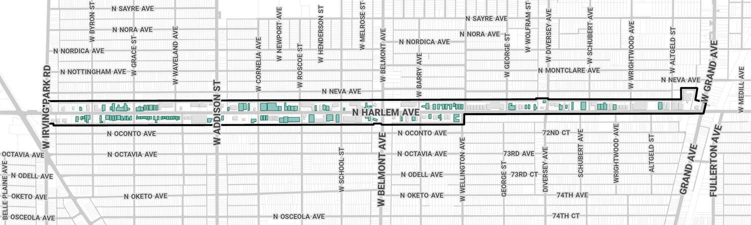
/
/ Auto No
13-30-316-008-0000; 13-30-316-009-0000; 13-30-316-048-0000
Figure 94. Harlem Avenue Corridor buildings that contribute to the character of the Corridor
62 3048 N Harlem Avenue
63 3050 N Harlem Avenue
12-25-215-018-0000; 1225-215-019-0000 c. 1988 Commercial / Industrial / Auto Yes New Traditional
12-25-215-014-0000; 12-25-215-015-0000; 12-25-215-016-0000; 12-25-215-017-0000
/ Auto No 64 3051 N Harlem Avenue
65 3067 N Harlem Avenue 13-30-109-001-0000; 13-30-109-002-0000 c. 1925; 1941 (Addition and Remodeling for Shell); 1991 (Addition) Commercial / Industrial / Auto Yes Utilitarian
66 3101-3115 N Harlem Avenue
13-30-100-011-0000; 13-30-100-012-0000; 13-30-100-013-0000; 13-30-100-014-0000; 13-30-100-015-0000; 13-30-100-022-0000;
3233-3249 N Harlem
13-19326-037; 13-19-326038; 13-19-326-047
13-19-326-005; 13-19326-006; 13-19-326007; 13-19-326-008; 13-19-326-009; 13-19326-010;13-19-326-011
N
3300-3302 N
87 3301 N Harlem Avenue
13-19-317-020-0000; 13-19-317-021-0000; 13-19-317-046-0000;1319-317-047-0000 1891
/ Auto No 88 3306-3308 N Harlem Avenue 12-24-423-032-0000 year built 1961 / renovated 2008 Commercial / Industrial / Auto No
89 3310-3318 N Harlem Avenue 12-24-423-045-1009 c. 1963-1972 Commercial /
90 3311-3317 N Harlem Avenue 13-19-317-018-0000; 1319-317-019-0000 1955
92 3320-3336 N Harlem Avenue 12-24-423-034-0000
1319-317-013-0000 2002
96 3339-3359 N Harlem Avenue 13-19-317-001; 13-19317-002; 13-19-317-003; 13-19-317-004; 13-19317-005; 13-19-317-006; 13-19-317-007; 13-19317-008
13-19-309-005-0000; 13-19-309-006-0000; 13-19-309-007-0000; 13-19-309-008-0000; 13-19-309-009-0000; 013-19-309-010-0000; 13-19-309-011-0000
(center section approx. 1/2 of building); c. 1952-1961 (rear 1/4 of building); c. 1972-1981 (from 1/4 of building)
201 7181 W Irving Park Road 13-19-100-001-0000; 13-19-100-002-0000; 13-19-100-003-0000; 13-19-100-004-0000; 13-19-100-005-0000; 13-19-100-006-0000 N/A
FOR THE INSTALLATION OF ARTWORK AT EXTERIOR FACADES
A significant component of the Harlem Avenue Visioning Study is the future installation of artwork on the exterior of existing buildings. The following best practices encourage the use of building artwork on existing and new buildings in the Corridor. Specifically, masonry may be stained or painted with an appropriate product or artwork may be installed on removable boards mounted to the exterior wall and anchored into the mortar joints. For property owners who wish to apply artwork directly to the exterior of their building, the following practices provide a step-by-step guide for how to appropriately install artwork while maintaining the historic materials of the building:
1. Define the art installation, including:
a. Identify the proposed location of the mural and, subsequently, the type of material the mural will be installed on (also referred to as the substrate), its construction method, and the material’s method for draining water.
b. Identify the expected service life of the mural (e.g., temporary or long-term).
c. Determine the application approach/type. See #5 below regarding appropriate coatings.
2. Next, the selected location of the mural should be inspected and assessed for any signs of deterioration (e.g., efflorescence, cracking, discoloration, staining, mold, distorted lintels, etc.).
3. If any signs of deterioration are observed, repairs should be made to correct the condition prior to the installation of the mural. A long-term maintenance plan should also be developed for the installation material and the mural. For example: what will happen when the building needs to be repainted? What is the inspection plan for the mural? How will touch-ups be undertaken?
4. Once any repairs to the substrate have been completed and a maintenance plan developed, the substrate should be prepped, including cleaning the material of any dirt or debris and removing any previous coatings that may cause a poor bond or lower permeability that may affect the application of a new coating.
5. When it is time to install the mural, a “permeable” or “breathable” coating should be used. For short-term installation, coatings such as milk paints, chalk paints, or limewash are appropriate. For longer-term murals, 100% acrylic paints, mineral silicates, or masonry/ mineral brick stains may be considered.
a. Coatings that should be avoided include: latex paints; “masonry paints,” as they are intended to bond well to masonry and do not provide a safe or breathable coating; cement-based pargings/ stuccos; and any non-breathable coating (e.g., latex, enamel, epoxy-based coatings, or anything with a low vapor permeance).
ACKNOWLEDGMENTS
PREPARED BY:
Chicago Department of Planning and Development (DPD) Management Team:
- Cindy Roubik, Deputy Commissioner
- Carmen Martinez, Supervising Planner
- Benjamin Corpuz, City Planner V
Consultant Team:
- site design group, ltd. (site)
- COLLABO, LLC
- McGuire Igleski & Associates, Inc. (MIA)
- Goodman Williams Group, Inc. (GWG)
State and City Departments:
- Chicago Transit Authority (CTA)
- Chicago Department of Transportation (CDOT)
- Illinois Department of Transportation (IDOT)
Key Advisors:
- Ellen Schmidt Tucker, CDOT
- Jason Meter, CTA
- John Baczek, IDOT
- Steven Schilke, IDOT
- Jason Salley, IDOT
- Jonathan Llyod, IDOT
- Jonathan Karabowicz, IDOT
- Omolara Johnson, IDOT
- Fawad Aqueel, IDOT
- Craig Bauer, IDOT
WORKING GROUP MEMBERS:
Ward Offices:
- Ald. Christopher Taliaferro, 29th Ward
- Ald. Nicholas Sposato, 28th Ward
- Kajie McMullen, 29th Ward Office
- Byron Watson, 29th Ward Office
- Katherine Blonski, 38th Ward Office
Government:
- Paul Volpe, Village of Elmwood Park
- Nina Grenke-Kosinski, Portage Park Chamber
- Michael Giordano, Portage Park Chamber
Property, Business Owners and Residents:
- Ron Onesti
- Stephanie Johnson
- Anthony Bartucci
- M. Gino Bartucci Jr
- Gino Bartucci Sr
- Frank Concialdi
- Jason Quaglia
- Nancy Galletta
- Adam Ramahi
- Frank Scaletta
- Frank Dipiero
- Greg Cirone
- Sandy Wilson
- Adriana Wilson
- Frank T. Concialdi
- Teresa Giannini
- Jack Buttitta
- Luigi Sciortino
- Joseph Giamarusti
- Saliatore Camarda
- Wayne Marks
- Marco Presta
- Enzo Ventrella
- Frank Dipaolo
- Raffiaele Meraoda
- Agostino Fiasche
- Leo Patino
- Tommaso Modica
- Daniel Strom
- Mario Biondolillo
- Elio Vivacela
HARLEM AVENUE VISIONING STUDY