Why We Need The Scheme
COASTAL SCHEME
Langstone Village is within three designated conservation areas that sit at the narrow channel between Langstone and Chichester Harbours. It is at serious risk of flooding. Within the village there are areas of historical and environmental importance including several buildings and two public houses which sit right on the water’s edge. It’s waterfront footpaths, saltmarshes and harbour views make it a popular spot for walkers, birdwatchers and photographers.
Langstone Road during Storm Pierrick, April 2024
Ageing Defences
FLOODING
AGEING DEFENCES
April 2024 recorded some of the highest tide levels ever seen in parts of the region. The higher than normal tides, combined with an intense storm surge, caused damage and severe flooding to residential and commercial properties, as well as flooding the A3023, the only access road to Hayling Island.
The current defence structures are deteriorating and without remediation, coastal erosion could lead to their sudden failure.
Currently 72 residential and 4 business properties are at risk of flooding from a 1 in 200 year tidal flood event. This is predicted to increase to 122 residential and 9 business properties in the future without the scheme.
With these critical upgrades needed, the scheme will enhance the protection of Langstone for the next 50 years. The scheme will keep Langstone and Hayling connected, safeguarding the village’s unique historic character, as well as its homes, businesses and cruicial transport links.
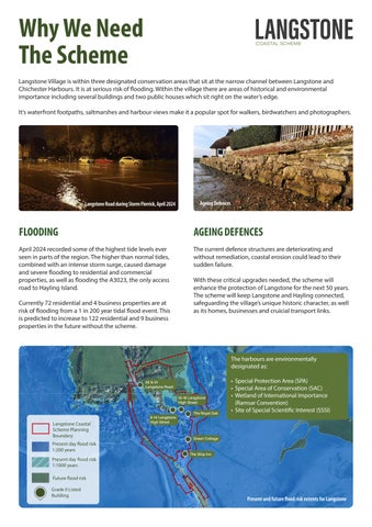
The harbours are environmentally designated as: 59 & 61 Langstone Road 16-18 Langstone High Street
Langstone Coastal Scheme Planning Boundary Present day flood risk 1:200 years Present day flood risk 1:1000 years
8-14 Langstone High Street
The Royal Oak
• Special Protection Area (SPA) • Special Area of Conservation (SAC) • Wetland of International Importance (Ramsar Convention) • Site of Special Scientific Interest (SSSI)
Green Cottage
The Ship Inn
Future flood risk Grade II Listed Building
Present and future flood risk extents for Langstone
Frontage Areas
COASTAL SCHEME
The scheme extends for 1km from Mill Lane to the west of the A3023 Langstone Road, along the Langstone quay and continuing to the meadows north of the Royal Oak pub. When completed, the new defences will provide a 1 in 200 year standard of protection. This means they will protect against significant coastal flooding events, with a 0.5% chance of occurring in any given year, also known as a 0.5% Annual Exceedance Probability (AEP). As sea levels rise due to climate change, the likelihood of coastal flooding will increase and the standard of protection will gradually reduce. After 50 years, the defences are expected to provide a 1 in 75 year standard of protection, equivalent to a 1.3% AEP. The works are divided into five frontages to reflect the varied character and constraints along its length, with the locations shown in the image below.
M
ill
e n a
L
Frontage 5 Langstone High Street to the Meadow north of Royal Oak 3 02 A3
Langsto
ne High
Frontage 1A Hayling Billy Line North
Street
Frontage 4 The Look Out to No. 24 Langstone High Street (The Winklemarket) Lan on gst eR d oa
Frontage 2 Hayling Billy Line South
Frontage Map
Frontage 3 The A3023 road to 9 Coastguard Cottages (The Look Out)
Introducing Your Project Team
Client
Client Delivery Team
Client Partner
Havant Borough Council have invested Community Infrastructure Levy towards scheme costs and are a major stakeholder in the project as Client. HBC are also the Local Planning Authority.
Coastal Partners are a team of specialist council officers and engineers who are managing the delivery of the scheme. They have experience in delivering expert and comprehensive coastal management services across 246km of the Hampshire and West Sussex coastlines.
The Environment Agency have awarded Grant in Aid Funding to the scheme, to reduce property flood and erosion risk to the area of Langstone.
Cost Manager
Designer
Contractor
Atkins Realis are a cost consultant who will provide quantity surveyor and commercial management support services to the client delivery team. They have a wealth of experience in the construction industry and have worked on similar schemes with Coastal Partners.
AECOM are an engineering consultancy, appointed as designer for the scheme. They are experts in this field having developed designs for similar coastal schemes around the country.
Jackson is a major UK-based civil engineering company, appointed as principle contractor for the scheme. They are experienced in flood and coastal defences, successfully delivering similar schemes across the UK.
Highways Authority
Heritage Lead
Land Agent
Hampshire County Council is the Highways Authority and a key project stakeholder with landowner interests. They are contributing towards the project.
Wessex Archaeology are a specialist Heritage and Archaeological consultancy who provided support during the design stage and will continue to support the scheme during construction.
Dalcour Maclaren provides specialist land and property support to Coastal Partners to help deliver the Langstone Coastal Scheme. We work with the owners and occupiers of land affected by the project on access, land rights and compensation matters.
Scheme Delivery
COASTAL SCHEME
HOW IS THE SCHEME FUNDED? The Project Team have secured over £23 million to deliver the scheme. Havant Borough Council led the way by awarding Community Infrastructure Levy funding (totalling £5.1m) which enabled the team to leverage other funding opportunities to the value of £18 million from the Environment Agency, £1 million secured from the Southern Regional Flood and Coastal Committee and £250,000 from Hampshire County Council.
WHERE ARE WE NOW? The main contractor Jackson Civil Engineering Ltd has been appointed, and essential ecological works are already underway across the site. These early activities will help protect local wildlife and ensure the area is ready for the start of main construction works, the start of which is scheduled to begin in April 2027. The scheme was originally expected to take up to two years to construct due to seasonal environmental restrictions associated with overwintering birds. By working closely with our contractor, Jackson Civil Engineering, construction is expected to be completed in under one year, significantly reducing the duration of disruption for residents, businesses and road users. While seasonal environmental restrictions to protect overwintering birds remain in place, construction activities will be carried out simultaneously at multiple locations across the site on both sides of the A3023. The works are divided into 5 frontages with several construction activities occurring along multiple frontages.
COMPOUND SET UP There will two compound sites in operation throughout the duration of the works. The main compound will be accessed from the A3203, Langstone Road, with the smaller compound being accessed via the entrance to The Ship Inn car park. Both areas will be reinstated on completion of the scheme.
Footpath Diversions
Traffic Map
Foreshore Access Track Compound Area
d
Traffic Management
eR
Access Point
on gst
Main Access Point
x x x
Lan
KEY
x x x
x x x x x x x x x xx x x x
KEY Frontage 1A & 2 diversion route Frontage 4 & 5 diversion route path x x Temporary closures
TRAFFIC MANAGEMENT To minimise disruption, all deliveries will arrive at the main compound before being distributed to work locations via one of three access points. Deliveries will be carefully managed to avoid unnecessary vehicle movements and to reduce traffic impacts on the local area. A foreshore access track will be installed to service the works from Frontage 3 all the way round to Frontage 5, with all large construction vehicles accessing the site from The Ship Inn to reduce construction traffic to Langstone High Street. Pedestrian and wheelchair access will be maintained to frontline properties and the Royal Oak, including vehicle access to the properties along the foreshore in Frontage 5. Emergency service access will be maintained throughout construction and we will continue to liaise with the emergency services throughout the works. During construction there will be a need to close paths to pedestrians and cyclists to ensure everyones safety. Diversions will be put in place, and areas will be reopened as soon we can.
Early Works
COASTAL SCHEME
Ahead of main construction, various preparatory works must be carried out. These works will be ongoing until April 2027.
VEGETATION CLEARANCE For the scheme improvements to take place, there is a need to clear certain areas of vegetation within Frontages 1A, 2, and 5.
Further clearance will take place in January 2027 focusing on trees and shrubs. While some areas will look noticeably different in the short term, they will be replanted with native, hardy, and fast-growing species. These plants are perfectly suited to the environment and will enhance the existing habitats for years to come. The scheme will replant more trees and vegetation than being removed.
MAIN COMPOUND Field
Extent of Replanting Frontage 5 Langstone High Street to the field north of Royal Oak
Field
d Roa one gst Lan
gh Str
eet
A30
Frontage 1A Hayling Billy Line North
Langst one Hi
The Royal Oak
The main site works compound will be located in the fields north of the Royal Oak and will remain in place for the duration of the scheme. This area will be fully reinstated when the scheme is completed. • Access & Parking: The site will be accessed via the A3023 Langstone Road. It will contain welfare facilities and all contractor and staff parking.
23
• Local Roads: There will be strictly no construction parking on any surrounding residential roads.
Frontage 2 Hayling Billy Line South
• Deliveries: All deliveries will be made directly to the compound. Materials will then be redistributed to the relevant frontages using one of three dedicated access points.
The Ship Inn
Field Maple Acer campestre
TEMPORARY JUNCTION Building a new temporary junction will be necessary on the A3023 Langstone Road in the New Year. This will provide safe access for construction traffic to the main compound. The junction work will take place overnight to minimise traffic disruption. The junction will remain throughout construction and incorporate pedestrian and cycle crossings. The area will be reinstated once the scheme is completed.
Dog Rose Rosa canina
Access route
Field
Main compound area ne sto ng
La ad Ro
Low-level clearance has already been Alder completed to protect the exisiting habitats. Alnus glutinosa Removing vegetation in stages has allowed ecologists to safely relocate protected reptiles, including slow worms and common lizards away from future construction zones. These cleared areas will be actively maintained prior to main construction starting to prevent the species returning too early.
New temporary junction
Mill Lan e
Mill Lane
Areas of Vegetation Clearance
Field
A3 02 3 Lang stone High Stree t
The Royal Oak
UTILITY DIVERSIONS
Reptile relocation
Essential utility diversion works are required to support the main construction phase. We are working with the utility companies to finalise the diversion work. Full details and schedules will be shared as soon as they are formally agreed.
Frontage 1A
COASTAL SCHEME
Hayling Billy Line North The Hayling Billy Line is a popular public footpath and cycle route which runs between the A3023, opposite the Ship Inn car park, through to Mill Lane, and is part of the ‘National Cycle Route’. There is a narrow, vegetated strip of land either side of the path, with residential properties beyond. There are currently no flood defences along this frontage.
Mill Lan
e
Access Point
Havant eR on gst Lan
Hayling Billy Line North, before the works
oad 023
A3
Frontage 1a Hayling Billy Line North Key Diversion route
Typical cross section of new defence
WHAT TO EXPECT? The scheme will provide a new 188-metre-long flood defence along this northern section in the form of a raised earth embankment. The existing path will be upgraded to a 3-metre-wide shared path located on top of the new flood embankment. The path will be raised and surfaced with smooth asphalt. The sides of the embankment will be seeded with a native hedgerow seed mix. Beyond this managed area, land affected by the construction of the new embankment will be reinstated through the planting of a mix of native shrubs and trees, creating a greener landscape, providing additional habitat for wildlife, and increasing biodiversity in the area.
Example of species to be planted (Dog Rose)
As the planting establishes over time, it will grow at different rates, support the local wildlife, enhance the appearance of the route and improve safety for users of this popular walking and cycling corridor. To support local wildlife, bat boxes will be installed on retained trees along this section. To ensure the path remains safe and accessible, no shrubs or trees will be planted within 2 metres of the shared-use path. In addition, a 1.5-metre-wide strip on either side of the route will be regularly mown and maintained to keep the path clear of vegetation.
Environmental Enhancements
Landscape & Public Realm
Frontage 2 Hayling Billy Line South The Hayling Billy Line South footpath and cycle route continues from Frontage 1A to the A3023, Langstone Road, opposite The Ship Inn car park. This section includes saltmarsh, scrub habitats, with the tidal creek supported by Langstone Spit. Residential properties lie to the east and currently there are no formal flood defences along this frontage.
Hayling Billy Line South, before the works
Native tree species will be planted, including some fruit trees. Bee posts, benches and information boards will be installed.
WHAT TO EXPECT Frontage 2 flood defences will include a combination of sheet-piled walls and raised earth embankments, with a new, upgraded 3-metre-wide shared path for pedestrians and cyclists which runs alongside the defence. See cross section on ‘Frontage 1A’ . This shared path will be realigned landwards to create space to allow expansion and roll back of saltmarsh habitat within the adjacent creek.
These improvements will provide greater flood protection for residential properties, reduce flood risk and improve safety for pedestrians and cyclists, avoiding encroachment on sensitive intertidal habitats.
Bee posts
NATIVE TREES
Raised earth embankments are used in lieu of sheet piles where the flood defence alignment crosses the existing utility pipes. As with Frontage 1A the landscaping will continue along this southern section of the Hayling Billy Line and will end with a 2-metre-wide section of the path. The path will run behind the bus stop to tie in with existing pavement levels, this provides separation of cyclists and pedestrians.
Acer campestre Field Maple
Rosa canina Dog Rose
Alnus glutinosa Alder
UTILITIES
CYCLE PATH
NARROW AREA
INTERTIDAL HABITAT
MATERIALS
Services are incorporated in the design footprint.
This is the part of the National Cycle Route 2 and will be a 3m wide path.
The design is constrained on either side by private properties, utilities & Langstone Harbour.
Minimise encroachment on protected habitat and enhance biodiversity.
The footpath will be surfaced with asphalt.
Frontage 3
Car Park at The Ship Inn This section of Frontage 3 extends from the A3023 Langstone Road, crossing The Ship Inn car park and continuing to the pub itself. The car park is a popular destination for visitors and provides access to Chichester Harbour via two slipways, which are commonly used as launch Lang stone High Stree points. t
THE SHIP INN RAISED CAR PARK
Havant
Lang ston e
on gst
Lan
High Stre et
The Ship Inn car park raised bund
Coastguard Cottages
eR oad
The Lookout
The Ship Inn
Frontage 3 Ship Inn Car Park to the Lookout
3
02
A3
A raised bund will be installed across The Ship Inn car park. It will span between the flood wall adjacent to the road and the flood wall around The Ship Inn courtyard.
Satellite compound
A3023 FLOOD WALL A sheet pile flood wall will run alongside the A3023 Langstone Road.
The Annexe Flood Wall The Ship Inn Courtyard Wall The Ship Inn Flood Wall
The existing fence along the road will be reinstated on completion of the works and extended to the entrance of The Ship Inn car park. The grassed area adjacent to the road will be reinstated with a wildflower seed mix and a new cycle rack will be installed near the car park entrance.
Raised Car Park
During construction access to The Ship Inn will be maintained.
A3023 Flood Wall
UTILITIES
SLIPWAY ACCESS
CAR PARK
BUSINESS
MATERIALS
There are several important services located within the design footprint.
The slipway adjacent to the A3023 will be maintained throughout construction.
The design allows for the area to be returned to current use after the work.
There will be new steps and a ramp for accessing The Ship Inn.
The car park surface will remain as black asphalt as required by the landowner .
Frontage 3 continued
The Ship Inn Frontage 3 continues to The Ship Inn along its courtyard seating area and the Annexe. There is no footpath along this stretch of coastline. Pedestrian access is along the foreshore or through the courtyard to meet the footpath which starts at the Lookout.
The Lookout The Annexe
The Ship Inn
Havant
Before Lang ston e
Old steps removed from this location
on gst
Lan
High Stre et
The Lookout
Coastguard Cottages
eR oad
The Lookout
The Ship Inn
The Annexe
The Ship Inn
3
02
A3
Frontage 3 Ship Inn Car Park to the Lookout
Satellite compound
New steel flood gate
After
THE SHIP INN COURTYARD WALL
THE SHIP INN FLOOD WALL
The Ship Inn courtyard retaining wall is an L-shaped reinforced concrete structure clad in engineered red brick to match the local character of the area. Access steps and a ramp will provide access to the courtyard. Upon completion of the works, the existing paving slabs will be reinstated and black handrails will be installed to improve safety.
New access steps added between footpath and foreshore.
The courtyard retaining wall will tie into The Ship Inn flood wall, a sheet-piled structure with Example of a glass floodwall a reinforced concrete capping beam that will replace the from the North Portsea existing breeze block wall. This flood wall will be topped with Coastal Scheme flood glass to preserve views from The Ship Inn and across Chichester Harbour. It will be clad on the seaward side with red bricks in keeping with the character of the area.
THE SHIP INN ANNEXE WALL
The Annexe flood wall is a continuation of The Ship Inn flood wall with no flood glass. At the western end of the flood wall, the existing steps to the foreshore will be removed and replaced with a ramped connection from The Ship Inn courtyard to Frontage 4 (The Lookout). This will comprise a new reinforced concrete footpath with an exposed aggregate finish and black handrails. A flood gate will be installed between The Ship Inn and the Annexe flood walls clad with timber.
FOOTPATH ACCESS
HARBOUR VIEWS
NARROW AREA
ENVIRONMENT
MATERIALS
Design improvements include better, wider footpath surfaces and easier foreshore access.
The scheme includes a glass top flood wall to retain views from The Ship Inn across Chichester Harbour.
The design is constrained on either side by private businesses, properties and the foreshore.
Design has minimised loss of intertidal habitat.
The new flood walls will be clad in red brick to tie in with other frontages.
Frontage 4
COASTAL SCHEME
The Lookout to The Winklemarket Frontage 4 extends between The Lookout and The Winklemarket (24 Langstone High Street).
La
ng
sto
ne
Hi
gh
Str e
et Winklemarket
The Green visualisation of after the works
Langstone
Havant
23 Road A30
Current footpath
The Ship Inn The Lookout
The Green
Frontage 4 Lookout to The Winklemarket/new realignment
WHAT TO EXPECT? fini
te
Fo
ot
ga
The scheme will provide new flood defences, primarily consisting of a new reinforced concrete flood wall. Depending on the area, the wall will be positioned either directly in front of the existing property boundary, or constructed as a replacement. The flood wall will be finished with brick or flint cladding to reflect the local character.
sh
Typical cross section of new defence
pat
h sur faci
g a ng
e r g
• The new flood defence will run around the edge of The Green, altering the footpath route to follow the quay wall alignment.
• Flood boards will be fitted at the gateway to the Coastguard Cottages during flood events and stored when not in use. • Access to the foreshore will be provided via new access steps at The Ship Inn • Existing drainage outlets will be extended through the new flood wall and fitted with non-return flap valves on the seaward side.
The scheme introduces a minimum 1.5 metre-wide concrete footpath with an exposed aggregate finish. The seaward edge will have a continuous handrail. This walkway connects directly to a brick-clad reinforced concrete quay wall, which will sit in front of the existing quay wall.
Location of new flood boards at the Coastaguard Cottages
Visualisation of new hand rails to be installed
SAFETY
PRIVATE PROPERTY
NARROW AREA
FOOTPATH ACCESS
MATERIALS
A new handrail will be installed, designed to improve the safety of the footpath
We are working with the landowners directly adjacent to the frontage
The design is constrained on either side by private properties and the foreshore
The Footpath is wider and will be surfaced with an exposed aggregate concrete finish
Materials being used in the project have been selected to reflect the local character of the area
Frontage 5
COASTAL SCHEME
High Street to the Royal Oak Frontage 5 extends from Langstone High Street to the meadows north of the Royal Oak and includes several Grade II listed properties. Existing flood defences in this area are limited to the vertical wall in front of the Royal Oak. The slipway which provides access to the foreshore currently has no formal flood defence leaving the High Street vulnerable to flooding during extreme high tides.
Proposed Flood Gates - Open
Proposed Flood Gates - Closed
Havant
Langs
tone H
igh Str eet
The Royal Oak
Flood Glass on flood wall in front of the Royal Oak
Frontage 5 Langstone High Street to The Meadow
WHAT TO EXPECT? This section of the scheme will provide a continuous flood defence between Langstone High Street and the meadows north of the Royal Oak and includes:
The existing slipway at the end of Langstone High Street will be replaced and ties into the Winklemarket flood walls and the Royal Oak flood walls on either side of Langstone High Street.
• High Street flood gates • Royal Oak flood wall • Flood gate at the egress steps • Allotment flood wall and removable flood barrier • Vehicle flood gate at No. 21 Langstone High Street • Footpath flood wall • An earth embankment connecting the new flood defences to higher ground north of the Royal Oak
The flood wall adjacent to the Royal Oak will include flood glass panels to help preserve views across Chichester Harbour. The path around the Royal Oak will be reinstated using the existing paving slabs where possible to maintain the character of the area.
The High Street flood gates will include a pedestrian gate and a vehicle gate, which will remain fixed open under normal conditions. They will only be closed during extreme flood conditions to help protect the area from flooding. The gates will be clad in sustainably sourced timber.
New drainage features and non-return valves will be installed through the new flood defence walls to help manage surface water and reduce the risk of flooding during extreme high tides. Access to the Royal Oak and the foreshore will be maintained throughout the construction works.
FLOOD GATES
ACCESS
LOCAL BUSINESS
MATERIALS
UTILITIES
Will remain open under normal conditions, allowing continued access between Langstone High Street and the foreshore.
Vehicle access to the foreshore at low tide will continue for residents while the flood gates are open.
Improved flood resilience around the Royal Oak will support continued access during periods of extreme high tides.
Materials have been carefully selected to complement the local character and historic setting of Langstone.
There are several utilities located within the design footprint which require diversions.
Frontage 5 continued
COASTAL SCHEME
Allotment to The Meadows This section of Frontage 5 runs from the allotment through to the meadows, north of the Royal Oak. Havant Before Allotment
Langs
tone H
igh Str eet
The Royal Oak
Frontage 5 Langstone High Street to The Meadow
WHAT TO EXPECT?
After - With gates closed
Flood gates
ROYAL OAK FLOOD BOARDS & ACCESS STEPS
EARTH EMBANKMENT
Between the Royal Oak flood wall and the allotment flood wall, removable drop in flood boards and reinforced concrete emergency egress steps will be installed.
An earth embankment will tie into higher ground levels in the field north of the Royal Oak, closing the flood cell. The embankment will be seeded with a meadow mix on the southern side and a hedgerow seed mix on the northern side.
ALLOTMENT FLOOD WALL & FLOOD GATES After the egress steps, a new reinforced concrete flood wall will be constructed behind the existing allotment wall (landwards). It will be raised to add height to the flood defence level.
The existing field access gate will be relocated to the west of the earth embankment. The existing field entrance will be planted up with native hedge species.
Timber clad flood gates will be installed at the allotment flood wall and across the driveway of No. 21 Langstone High Street.
FOOTPATH FLOOD WALL
Hazel (Corylus avellana)
A new reinforced concrete flood wall will run along the boundary of No. 21 High Street with a replacement closeboard fence on top to maintain privacy. The footpath leading to the meadow will be reinstated using aggregate gravel. The area beside the footpath, used to facilitate construction of the flood wall will be reinstated with mixed native wetland planting and native tree species.
Hazel (Corylus avellana)
Dog Rose (Rosa canina)
Royal Oak flood wall emergency egress steps
Heritage and Archaeology
COASTAL SCHEME
The Langstone Coastal Scheme will provide enhanced protection to the area’s rich heritage, while ensuring that any archaeological remains are carefully managed and preserved.
CONSERVATION AREAS
ARCHAEOLOGY
Preserving 10,000 Years of History The Langstone Coastal Scheme is proud to have Wessex Archaeology as the project’s Heritage Lead. Langstone’s rich history extends deep into the past and protecting it has been a core focus through every stage of the scheme’s development. Building on studies completed to date, an archaeological strategy is being developed to support the construction phase which will include investigative boreholes and trial trenches. This exciting work will teach us even more about Langstone’s past with potential for evidence of human activity from prehistoric periods, Bronze Age funerary activity, salt working, Romano-British agriculture, and the medieval period onwards!
LISTED BUILDINGS
The team will deliver a scheme that is affordable, environmentally responsible, and aligned with the heritage and character of the area. Sympathetic design, construction methods and high quality materials will all contribute to protecting the heritage assets present.
Borehole investigations
HISTORIC LANDSCAPES ARCHAEOLOGICAL BRIEFING A retained archaeologist will be appointed to work with the construction team before works commence and where required, undertake an archaeological watching brief during key stages of construction.
WHAT HAPPENS IF REMAINS ARE FOUND? Should any archaeological remains or artefacts be discovered, work within the affected area will cease immediately until the County Archaeologist and Historic England have reviewed the findings and approve the continuation of work.
A drilling rig takes a vertical column or borehole through the ground and underlying earth and rock. By extracting samples, ‘cores’, we can see the sequence and understand the processes by which they formed. This helps us understand how the environment has changed overtime.
CONSIDERATE CONSTRUCTION Within the Conservation Area and in the vicinity of Grade II listed buildings, sensitively designed hoardings will be used to minimise visual impacts. Contractors will also be required to adhere to the Code of Considerate Practice throughout construction.
Environmental Enhancements
Alongside improved coastal protection, the scheme will create new opportunities for nature, biodiversity and people. From native planting and wildlife habitats to new seating, interpretation and public realm features, these improvements will help enhance Langstone’s special coastal environment for years to come. The completed scheme will leave the natural environment in a measurably better condition than it was before the works. One sided
Oystercatcher
You are here
To Eastern Road
The Waders
To Anchorage Park
PLANTING
BEE POSTS
BEETLE LOGGERIES
Wildflowers and native tree species, including fruit trees, will be planted along the Hayling Billy Line and in other certain areas of the scheme.
Bee posts and bricks will be installed throughout the scheme to help biodiversity and local plant reproduction, boosting ecosystem health.
Stag Beetle Loggeries provide a place for them to lay their eggs and for their larvae to feed on.
East Bastion
As the tide falls, Langstone Harbour’s mudflats become a vital feeding ground for wading birds. Using long legs and sensitive bills, these birds probe the mud for worms, shellfish, and tiny crustaceans. The changing tides reveal a constantly shifting buffet. The Oystercatcher is a large, stocky, black and white wading bird. It has an orange-red bill and reddish-pink legs. Through the colder months, they eat cockles and mussels, using their strong bill to prise open or hammer their prey. Langstone Harbour is also home to Europe’s largest wading bird, the Curlew. In the winter, you’ll see Curlews feeding in groups on tidal mudflats, saltmarshes and nearby farmland. Look for its down-curved bill, brown upperparts, long legs and listen for its evocative, bubbling call. While some of our birds spend the winter in Ireland and France, we get an influx of Scandinavian-breeding Curlews here, who make the most of our relatively mild winters.
To Highbury Railway Bridge
Pathway Path Continues Heritage Information Information Post Moat Hilsea Lines Shoreline
Centre Bastion and Portsbridge
E N
S W
Scale 0
150m
300m
Curlew (Numenius arquata)
Example information board from North Portsea Coastal Scheme
BAT BOXES
VERTIPOOLS
INFORMATION BOARDS
Bat boxes will be installed on existing trees along the Hayling Billy Line to support the population of local bat species in the area.
Artificial vertical rockpools for creating wildlife habitats will be incorporated to the scheme. The scheme will be teaming up with Artecology Create and the local community to design Vertipools unique to Langstone.
A series of information boards to highlight the special environmental features of the Langstone coastline are due to be installed.
We are committed to delivering a scheme that offers long‑term value, enhances local amenity and secures measurable environmental benefits, including a minimum 10% biodiversity net gain.
SALTMARSH The harbours contain areas of saltmarsh, an important habitat for marine wildlife. Existing saltmarsh will be protected during construction and the scheme also seeks to provide opportunities for increased colonisation, supporting birds species, fish and marine mammals.