
8 minute read
1.0 Introduction


1.1 Overview
This PoM has been prepared to provide a framework for the use and management of public land classified as ‘community’ at Ferry Park Reserve, Maclean.
1.2 Need for this Plan of Management
The Local Government Act 1993 (LG Act) requires all Council-owned land to be classified as either ‘community’ or ‘operational’ land. Land classified as community land is to be managed and used in accordance with an adopted PoM.
Consequently, the purpose of this PoM is to:
Ensure compliance with the Local Government Act 1993, Environmental Planning and Assessment Act 1979, Clarence Valley Council LEP 2011 and other relevant Legislation and policies;
Provide direction in the development, use and management of facilities and land on the Ferry Park Reserve; and
Contribute to the Council's broader strategic goals and vision as set out in the community strategic plan - The Clarence 2027.
1.2.1 Previous Plans of Management
There are no previous plans of management for the Ferry Park Reserve. Ferry Park Reserve was originally classified as ‘operational’ land by the Maclean Shire Council in 1994. However, during the land rationalisation project in 2016 it was identified that this classification was invalid and the land defaulted to the community land classification. In 2018 Council intended to reclassify the land to ‘operational’ to reflect the intent of the former council, however it remained as ‘community’ land classification due to concerns raised by LCACA and community members. A PoM is now required to outline management principles for the land.
1.3 Categorisation of Land
This PoM categorises the land as:
General Community Use –The area predominantly containing the Arts & Craft Centre and retail space, car park and open space area.
Natural Area –‘Foreshore’ –The riparian area adjoining the South Arm Reach of the Clarence River.
Refer Appendix 1: Ferry Park –Proposed Land Categorisation, for details of the ‘General Community Use’ and ‘Natural Area –Foreshore’ areas.
1.4 Land Description
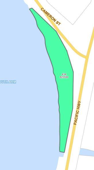
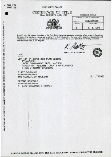
The Ferry Park Reserve being Lot 434 DP 823599 is public land that is owned and managed by Clarence Valley Council. The reserve area is approximately 7,244 m 2.
The reserve adjoins the South Arm Reach of the Clarence River and is located in Maclean at 46 Cameron Street (northern boundary), the current Pacific Highway (eastern boundary) and the South Arm of the Clarence River on the western boundary (Figure 1.1).
Figure 1.1: Ferry Park Reserve Locality Plan
The reserve is located on flood prone land with class one and three acid sulphate soils, and in the coastal zone and coastal use area listed under the State Environment Planning Policy (Coastal Management) 2018 (CMSEPP).
The reserve also includes land that is road reserve under the control of the Transport for NSW (approximately 1,400 m 2 ) that is part of the existing Pacific Highway and road reserve under the control of Council as the local roads authority (approximately 1,400 m 2 ) of land that is part of Cameron Street.
A building has been constructed in the centre of the reserve for the purpose of a community-based visitor and retail space. The current use of the building is for restaurant/café, an arts and crafts gallery and a visitor information portal.
The Woolgoolga to Ballina Pacific Highway upgrade will change the existing highway alignment to the east of its current location, with an interchange for traffic entering and exiting Maclean and the Lower Clarence being constructed to the north of the current southern entrance to Maclean at Cameron Street. The upgrade is due to be completed by the end of 2020 which will divert the traffic currently traveling the existing Pacific Highway away from Ferry Park Reserve.
1.4.1 Land History
The following is a brief history of the land.
Date 30 October 1969 Details
Private land previously owned by Hector Cameron resumed for main roads purposes (motorway) (Charting Map - County of Clarence, Parish of Taloumbi)
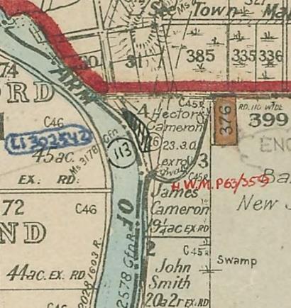
Land area
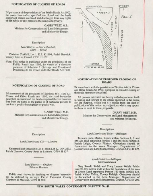
Date 21 May 1993 Details Road officially closed (NSW Government Gazette no. 49, p.2425)
Land area
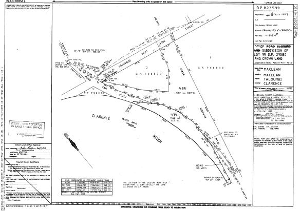
30 July1993
Lot 35 DP 230180 and Crown land subdivided to create Lot 434 DP 823599 and dedicated to community use
Date 4 March 1994 Details Maclean Shire Council receives certificate of title to the land
Land area
1.4.2 Land Use History
In 1981, prior to the creation of Lot 434 DP 823599, Maclean Rotary Club organised for the installation of the old Ashby Ferry and cane punt on the vacant road reserve which is now Ferry Park Reserve. The site was further developed over the following years as a roadside rest stop managed by the Maclean Rotary Club (Rotary Club of Maclean 2004, p.39).
From 1986 to 1993 LCACA raised funds and gained funding towards the construction of a building to house the association’s activities after a submission to Maclean Shire Council in 1986 regarding working together towards a community arts resource centre (LCACA (b)). During this time sites were assessed by Maclean Shire Council and LCACA for suitability for an Arts and Crafts Gallery, office and studio, with the Ferry Park Reserve highlighted as a priority site.
December 1992, NSW Roads and Traffic Authority approved the use of “Ferry Park” rest area for the site of a Tourist Information Centre and the closing of a section of the public road as shown in Appendix 2: Plan of RTA Road Closure (Maclean Shire Council Ordinary Meeting Minutes 13 January 1993, p.73).
Circa 1993, LCACA and Maclean Shire Council contracts an architect and building plans for the current Arts and Crafts Centre were approved 20 July 1993 (Appendix 3: Ferry Park site plan and building plan).
19 December 1993, LCACA enters into a lease agreement with Maclean Shire Council for a period of 15 years, with renewal period option of 10 years over part of the facility at Ferry Park, for the purpose of Arts and Crafts Studio, office and gallery.
In 2016, Council identified that the original classification of ‘operational’ land at Ferry Park inherited from the former Maclean Shire Council was invalid and therefore defaulted to the ‘community’ land classification.
In 2018, Council intended to reclassify the land to ‘operational’ to reflect the intent of the former council. On the 8 August 2018 Council held a public hearing to provide an opportunity for the community to address the reclassification as per section 29 of the Local Government Act 1993. Submissions were made by LCACA and community members against this reclassification. Ferry Park remained ‘community’ land and a PoM was drafted in 2019 to direct future management of the land.
Over the last 26 years LCACA have operated solely through volunteer members providing a workspace and Arts and Crafts Gallery at Ferry Park for the local arts community to showcase works through Artist of the month exhibitions, annual exhibitions and competitions and youth arts displays (LCACA (a)).
LCACA and the Arts and Crafts Gallery at Ferry Park continue to support the Clarence Valley Cultural Strategic Plan through the promotion of cultural activities to the community and visitors to the Clarence Valley, providing for the participation and engagement in creative and cultural activities; involvement in Council Special Events promotion and also maintains a strong volunteer membership base.
1.5 Development of the Land
Existing Development
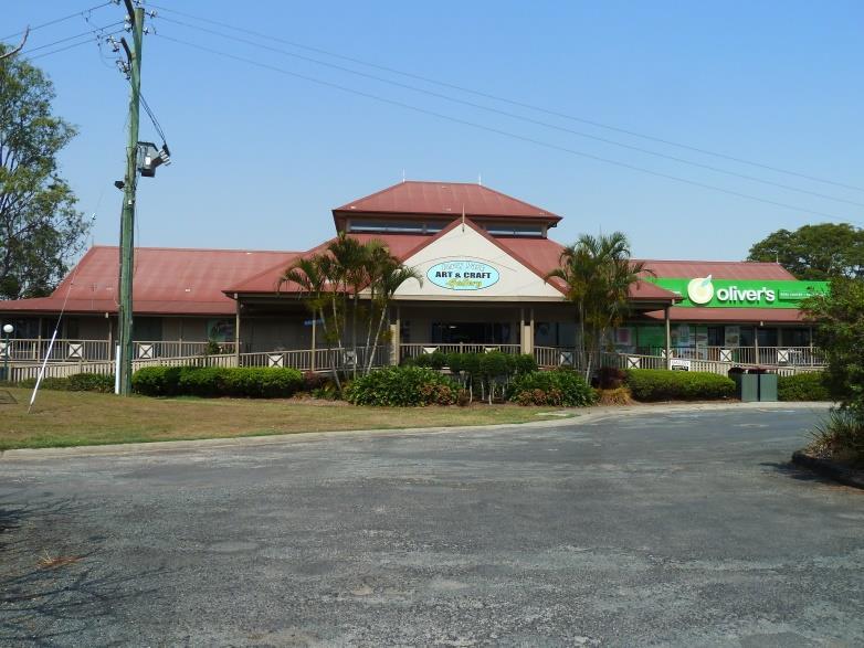
The Ferry Park Reserve has an existing community-based arts and craft, visitor and retail space built on the land at the date of exhibition of this PoM (Figure 1.2).
The building was constructed as a multi-purpose community facility which was officially opened on 5 February 1994. The Lower Clarence Arts and Crafts Association raised $50,000 with matching grants from both Commonwealth and State Governments between 1991 and 1993, towards establishing an Arts and Crafts Office, Studio and Gallery at Ferry Park. Part of the facility was also designed to provide for a restaurant and visitor information centre.
Figure 1.2: Existing Tourist Facility
Surrounding Development
The Ferry Park Reserve is located adjacent to the Pacific Highway, 1,500 m south of Maclean Town Centre on the eastern bank of the South Arm of the Clarence River. Surrounding lands are made up of farmlands, with the closest residential and industrial lands being in Maclean and Townsend. The Woolgoolga to Ballina Pacific Highway upgrade is due to be completed by the end of 2020. It is possible that a service centre will be constructed near the Maclean Interchange to the North-east of Ferry Park after completion.
Future Development of the Land
This PoM proposes, within the requirements of relevant legislation, future development of the land for the purpose of effecting:
Alterations, additions and improvements to the existing land and buildings to provide improved facilities for the uses permitted by this PoM including alterations, additions or improvements to enhance community-based uses including education, family, children’s, cultural, leisure, health, religious and social activities and commercial opportunities.
Alterations to carpark layouts to improve parking associated with future development.
Rationalisation of the facilities to improve effectiveness and utilisation for increased patronage.
Future development may include: Extension(s), renovations and improvements to the existing building pursuant to State Environmental
Planning Policies (SEPP), and Council’s Planning instruments, Development Control Plans (DCP) and policies;
Upgrades to the existing public facilities and car parking to accommodate increased patronage; and
Other infrastructure to meet the needs of the community as identified in Council’s community strategic plan - The Clarence 2027and further explored in Council’s Cultural and Community Facilities Plan (2009).
It is proposed to relocate the cane punt and ferry to the Lawrence Museum’s maritime section.
The ferry and cane punt are identified as a single heritage item (No. 194) “Punt and former Ashby ferry (both stationary)” of local significance in Schedule 5 of the CVLEP. Clause 5.10 (2) of the CVLEP requires development consent for the demolition or relocation of any heritage listed item.
This PoM permits the removal and relocation of the existing cane punt and ferry which is currently situated on the reserve and further rehabilitation of the site provided that it complies with the CVLEP’s development approval process. Improvements as part of the rehabilitation may include gardens and grassed areas, educational interpretation on the history of the ferry and punt, park furniture, playground equipment, public facilities or infrastructure to meet community needs.

