5 minute read
Doonaha

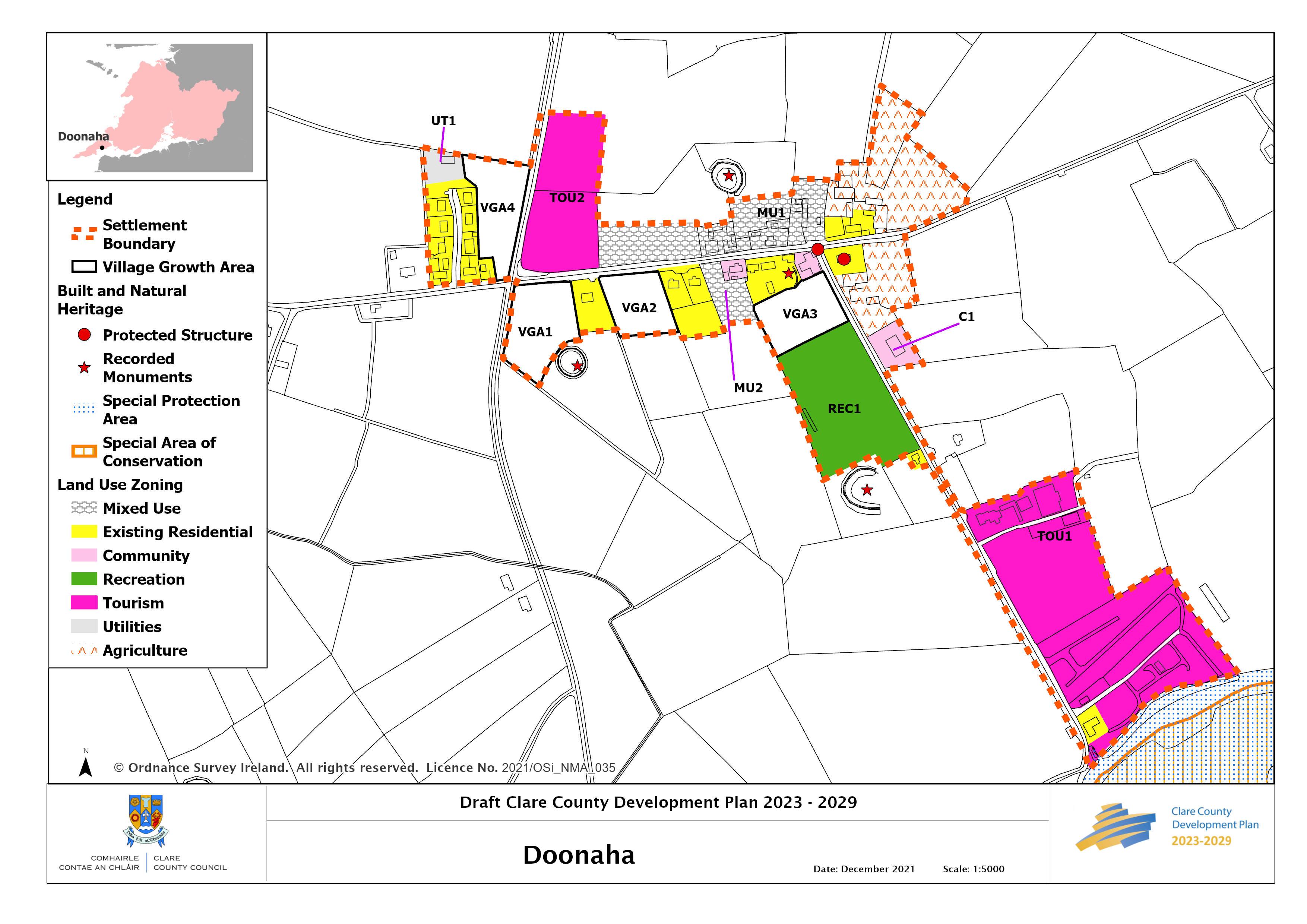
Doonaha
Location and Context
Advertisement
Doonaha is located on the Loop Head Peninsula near the shores of the Shannon Estuary, northeast of Carrigaholt and close to Glasheen Beach. Extensive views are afforded of the estuary, particularly from the quay road and from the main road through the village. The surrounding landscape is quite sensitive in terms of its capacity to absorb development.
The facilities in Doonaha are centred on the junction in the village and include a church, GAA grounds, O’Curry’s Hall, and a primary school. There is a large caravan and camping site by the quayside.
Future growth will be targeted towards the main settlements of Carrigaholt and Kilkee, however, there is potential for some limited development within Doonaha without having a detrimental impact on the village.
The village is served by the West Clare Regional Water Supply. There is no wastewater treatment infrastructure and any future development, including alterations to existing commercial or employment generating development will require private wastewater treatment subject to suitable site-specific conditions and must ensure they comply with the EPA Code of Practice for On Site Wastewater Treatment Systems. The Natura Impact Report accompanying this Plan (Volume 10a) provides relevant mitigation measures and recommendations at site and project level.
General Objectives
• To encourage the small-scale expansion of the village throughout the lifetime of this
Plan in order to sustain and increase the population of the area and support new and existing services in the village; • To ensure that future growth in Doonaha is incremental and small scale in nature, relative and appropriate to the scale, size and character of the population and services in the village; • To support the provision of infrastructure to allow for future growth of the village; • It is recognised that the shoreline in proximity to Doonaha Quay is eroding. An appropriate set-back will be required of all future developments in proximity to the shoreline to minimise the requirement for engineering interventions in the area and as an adaptation measure to the impacts of climate change; and • To support the development of a settlement network on the Loop Head Peninsula including Doonaha along with Querrin and Carrigaholt, to assist collaborative projects and the sharing of assets and strengths including developing its economic and tourism potential as a stopping point on the Wild Atlantic Way.
__________________________________________________________________________________ Draft Clare County Development Plan 2023-2029
Employment and Enterprise
Agriculture remains an important part of the local economy. In order to support economic development, the Council will support home-based economic activity and encourage farm enterprise and agri-tourism in Doonaha.
Tourism
Given its location on the Wild Atlantic Way there is scope for further limited tourism development in Doonaha to enhance the economy of the village and the surrounding area. In this regard it is an objective:
• To support the continued development of existing tourism assets and the development of additional tourist facilities and services on the Loop Head Peninsula in a sustainable manner, subject to the requirements of the Habitats Directive. The provision of accommodation in the form of holiday homes shall not, in general, be considered favourably.
Large-scale development proposals on Tourism zoned lands will be required to submit a Masterplan for the overall site. The Masterplan shall give particular attention to matters of design and layout and how these matters reflect the character of the village and must also address the capacity of the site and the village to absorb the proposed development from a visual, environmental and social perspective.
In order to promote tourism development, the following zoning objectives are identified.
TOU1 Adjoining the Quayside
This site currently provides caravan park accommodation for tourists and also includes an additional area of land to the north of the existing facilities. The shoreline adjoining the caravan park is subject to coastal erosion and the additional tourism lands to the north are zoned to allow for the managed retreat of the existing facilities if and when required in the future. This area can also be developed for further tourist facilities in Doonaha, for the benefit of the village itself and the wider area. Development must be reflective of the scale, size and character of the existing settlement. The provision of accommodation in the form of holiday homes shall not, in general, be considered favourably.
Strategy for Growth and Sustainable Communities
Doonaha’s high quality coastal location is an attractive place to live proximate to Kilkee. The strategy for the sustainable growth of the village and its community is through consolidation and regeneration that promotes compact sequential growth and supports and strengthens a sustainable village community and its rural hinterland. This will be achieved by encouraging small scale growth in areas which make a positive contribution to the overall enhancement
__________________________________________________________________________________ Draft Clare County Development Plan 2023-2029
of the village and sustains it into the future. In line with this approach and to promote vibrant rural villages, village growth areas have been identified which provide opportunities and choice for development, including small scale commercial, enterprise, community, services/facilities as well as small scale cluster housing, all of which offers a viable and attractive option for rural living within a village community and setting. A number of infill sites are identified within the settlement to provide for low density development.
In addition to compliance with the policies and objectives as set out in Volume 1 of this Plan, any development proposals for dwellings on areas identified for village growth shall be for permanent occupancy only.
Place Making and Regeneration
The linear form and simple plastered boundaries of the original settlement give a sense of place to the village. The long straight approaches create a particular need for traffic calming and defined gateways are needed. The principles for place making on the Wild Atlantic Way are set out in Chapter 14 Volume 1 of this Plan.
Flooding and Flood Risk
The Strategic Flood Risk Assessment (Volume 10(c)) accompanying this Plan advises that a drainage impact assessment is required to manage surface water in the village. Itis recommended that an emergency plan is prepared for development within the TOU1 site.
__________________________________________________________________________________ Draft Clare County Development Plan 2023-2029