
16 minute read
CONSULTATION


Artist’s Impression of the One Shannon Hub
Advertisement
High-Quality Homes Retail / Service Hotel / Apart-hotel Office
Innovation Campus Community
View northwards along Bóthar na Rinne Green Corridor linking to the Estuary to the Innovation Campus
High Quality Housing One Shannon Hub
The Shannon Town Park was designed to contribute to the recreational amenities of Shannon Town and the revitalisation, regeneration and improvement of the urban environment in the urban centre of Shannon. The park design has been informed by extensive public consultation and has created linkages with other key amenity areas in the wider area including the Shannon Estuary Embankments cycle and footpath and the Shannon Wetlands Restoration Project.
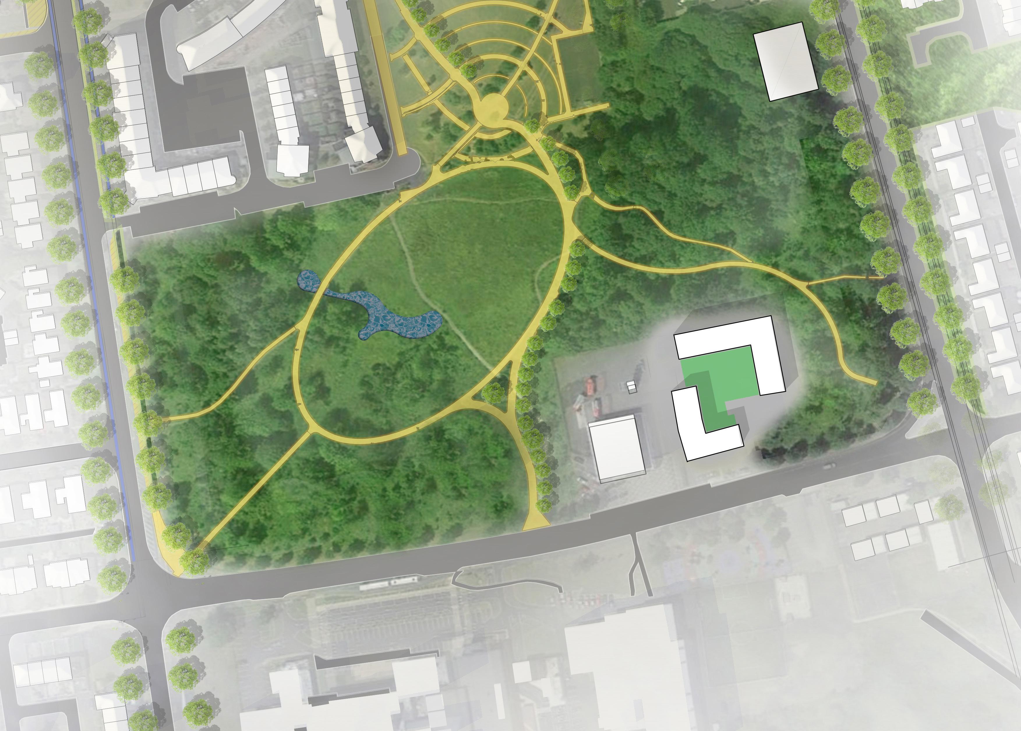
Step-Down Housing in Shannon Town Park
The potential for step-down housing is proposed on the existing Area Office site adjacent to the fire station, following the relocation of the offices into the town centre. Step down housing will ensure a mix of housing tenure on a pleasant town centre site overlooking the park. Development on this shall occur only after obtaining an alternative location for the existing local authority machinery yard in Shannon.


Green Connection to the Estuary Step-Down Housing

Improved Public Realm and Parking Strategy
This masterplan proposes to improve the public realm substantially within Shannon Town Centre by placing pedestrians and cyclists above vehicles and creating an enhanced streetscape which is active and dynamic where car parking is moved from the core and repositioned outside the centre.
A comprehensive Transport Technical Report has been commissioned, which shows how it is possible to remove the large surface car parks from the centre of Shannon today and reposition them elsewhere in the town centre, including on-street parking, which will create a more urban, pedestrian-friendly, and human-scaled environment typical of other Irish towns and cities.
This redistribution of vehicles means that car parking will still be possible for visitors to the town centre, but the urban landscape will not be completely dominated by vehicles as it is today. It is important to note that any future redevelopment of the town centre area carried out will be done so whilst having regard to existing businesses within the vicinity.
A full car parking strategy was completed to support the masterplan.

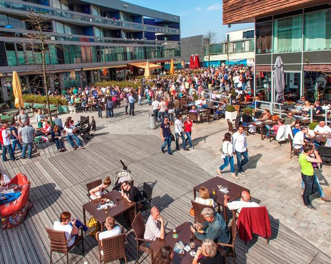
Grafton Street, Dublin

Clanbrassil Street, Dundalk Shannon Town Centre Today


08

Implementation, Delivery & Next Steps

Implementation
Implementation Strategy
The Shannon Town Centre Masterplan is a spatial framework for the regeneration and enhancement of Shannon’s town centre. The spatial framework has been elaborated through engagement with the community, key stakeholders, including land owners, local businesses, investors, the Shannon Chamber of Commerce, and Elected Members. An initial draft was published for public consultation in summer 2021.
Feedback from these has been invaluable in shaping the aims, objectives and principles of the masterplan framework. Delivering a plan will now require all stakeholders to assume ownership of the masterplan as a shared vision for Shannon Town Centre.
The masterplan developed by Clare County Council sets out key urban design public realm principles that will underpin a vision for future growth and transformation. Importantly, the plan provides an integrated urban development approach underpinned by an economic viability assessment to enable the local authority leverage a range of funding opportunities at EU and national level, e.g., Urban Regeneration Development Fund (URDF). In addition, the plan provides a clear focus for the delivery of a number of key intervention areas and projects which, if implemented, will transform the economic, social and cultural development of Shannon and the built environment and public realm. The purpose of this chapter is to set out the implementation steps to transforming the vision in this masterplan to project delivery in a plan-led approach.
Chapter 3 identified the landownership, in particular the absence of lands in the town centre under local authority control. In developing a roadmap for implementation, Clare County Council will rely significantly on the ability to leverage development from individual landowners to promote interventions in the town centre in accordance with the masterplan’s objectives. A key element will be the local authority’s acquisition of key sites to harness early development opportunities, further emphasising Clare County Council’s commitment to implementing this masterplan.
The following sets out the implementation stages of the plan:
• Consult and engage with key stakeholders and interests, and obtain endorsement.
• Establish a Dedicated Implementation Company, e.g.,
DAC, or other delivery vehicle with a sole focus on driving the implementation of the masterplan.
• Establish a dedicated project team to manage the detailed design development of the masterplan.
• Design a comprehensive engagement strategy that enables a collaborative approach for the next stages of developing the project.
• Develop a marketing strategy to attract potential investors.
• Enhance collaboration and existing networks between local authority, enterprise, industry, Shannon
Chamber and state agencies to focus on delivery.
• Deliver early wins, with a focus on enhancement of public realm and open spaces.
• Clare County Council to acquire ownership of strategic enabling sites in the town centre, in particular the site proposed for the One Shannon hub.
• Develop a detailed design brief for the One Shannon hub, together with a plan for funding and delivery.
• Prepare an application under URDF and a range of other funding sources for developing town centre.
• Develop a public realm framework for the town centre and linkages with Shannon Free Zone (west and east),
Smithstown, Shannon Estuary, and wider regional destinations.
• Define objectives and principles for a decarbonisation strategy for the town centre. • Develop a sustainable mobility strategy in liaison with
Shannon Airport and Shannon’s employment areas and the owners of the shopping centre.
• Enhance pedestrian and cycle connectivity from the town centre to the estuary, estuary greenway (the
Shannon loop), and neighbouring employment areas.
• Develop an urban design guide for future development, with an emphasis on a zero-carbon approach.
• Design and implement investment incentives and investigate possibility of utilising the Section 48
Development Contribution Scheme such as zero development contributions for town centre developments.
• Identify opportunities for public funding via the URDF, and prepare applications for projects such as the One
Shannon hub, urban design works, the new road along the eastern edge of the Innovation Campus, or any key enabling works.
• Establish a partnership approach to deliver privatesector led housing development in the area. • Design a development strategy for the Innovation
Campus. Establish principles for a collaborative approach between Clare County Council and the current owner of the site. Clare County Council in collaboration with the landowner, will market and promote these town centre lands as the key destination in Shannon for the merging of training, enterprise and innovation. Seek alternative location in Shannon for Council Machinery yard compound.
• Work in partnership with housing agencies, voluntary sector, older person’s network to develop proposals for independent living on the site of Shannon MD offices, following the relocation of offices to the town centre.
• Investigate possibility of acquisition by Clare County
Council of the new town centre plaza.
• Develop a brand for Shannon Town Centre.
Environmental Assessments
Appropriate Assessment
Pursuant to Article 6(3) of the habitats Directive, the Shannon Town Centre Masterplan has been assessed with regards to the potential for significant effects in relation to any European site and therefore warrants the undertaking of Appropriate Assessment.
In carrying out this screening, the Council has considered the relevant matters specified under Part xAB of the Planning and Development Act 2000 (as amended), including:
• Existing Clare County Development Plan 2017-2023 (as varied) and associated Environmental Assessments as contained in Volume 10, AA Natura Impact Report and Strategic Environmental Assessment
Environmental Report.
• Specifically, Volume 3b, Shannon Municipal District of the Clare County Development Plan 2017-2023 (as varied).
• Existing Shannon local Area Plan 2012-2018 (as varied).
As the masterplan is not directly connected with or necessary to the management of any European Site, and following the undertaking of Screening for Appropriate Assessment it has been determined that there is no potential to affect the integrity of any European Site(s). Consequently, it has being determined that Appropriate Assessment of the Shannon Town Centre Masterplan is not required. This process has been undertaken in accordance with the requirements under: European Council Directive 92/43/EEC of 21 May 1992 on the conservation of natural habitats and of wild fauna and flora; and European Union (Birds and Natural habitats) (Amendment) Regulations 2021.
In conclusion, in accordance with Article 6(3) of the habitats Directive, considering all matters relevant, it has been determined that the Shannon Town Centre Masterplan is not likely to have a significant effect on any European site(s) within, or adjacent to the study area boundary.
Strategic Environmental Assessment
An SEA Screening Report with respect to Schedule 2A ‘Criteria for determining whether a plan is likely to have significant effects on the environment’ was prepared by Clare County Council with respect to the Shannon Town Centre Masterplan. It determined that SEA is not required under Directive 2001/42/ EC of the European Parliament and of the Council of Ministers of 27 June 2001 on the Assessment of the Effects of Certain Plans and Programmes on the Environment; and European communities (Environmental Assessment of Certain Plans and Programmes) Regulations 2004 (SI No. 435 of 2004), as amended. The SEA assessment took into consideration the findings contained with the Screening for Appropriate Assessment.
09
Appendix
Milton keynes was one of the last and arguably more important New Towns built under the 1946 New Towns Act. Developed in the 1970’s to relieve housing demand pressure in london, its unique location, equidistant from london, Birmingham, Oxford and Cambridge, has provided it with an excellent geographic and economic advantage.
The ‘Plan for Milton keynes’, published in 1970 by the Milton Keynes Development Corporation, envisaged a flexible framework that allowed for a large degree of freedom in the more detailed design of residential neighbourhoods and economic hubs. The urban grid set up a spatial system that could adapt to future requirements whilst not imposing a pre-defined urban image. The principle of overlapping catchment areas was envisaged to avoid creating inwardlooking neighbourhoods and encourage the use of different local centres (both existing historic towns and villages and new hubs, including Milton keynes Central).
Milton keynes, over the past decades, has been successful in attracting residents and businesses. It has sustained high levels of economic growth and has seen its population grow well beyond the original objective of 250,000 people. A new local Plan (Plan:Mk), currently in consultation, will guide the city’s growth up to 500,000 people. Informed by recommendations from the Mk2050 Futures Commission, Plan:Mk will also have to respond to emerging issues such as fast demographic change, multiple deprivations of part of its population, retention of young talent, and new funding and investment to upgrade its infrastructure.
The Commission has proposed to underpin the delivery of its vision for an inclusive growth for Milton keynes with six projects:
Milton Keynes, UK
Hub of the Cambridge - Milton Keynes - Oxford Arc
Creating a knowledge intensive cluster and promoting closer collaboration with Cambridge and Oxford.
MK:IT — A new university with a focus on research, practice and life-long learning in partnership with other national and international institutions. Learning 2050 — creating a collaborative framework between secondary schools, parents, businesses and other sources of support to improve accessibility to quality secondary education for all of the city’s students.

MK:IT - proposed university campus
Smart, Shared, Sustainable Mobility — Transport for all, integrating technology, new spaces for sustainable mobility, and an improved public transport service.
Renaissance:CMK — harnessing investment for high quality projects in the centre, location of Mk:IT, and integrated city-wide linkages.
The Creative and Cultured City — harnessing the creative energy of local residents via cultural and sporting events and festivals.
Delivering these projects will rely on strong commitment and leadership from the council, setting up a development body, establishing strong partnerships with the private sector, using land value uplifts, and secure support from Central government via a ‘new deal’ for regional growth.
key lessons:
• Reinforcing the city’s regional role to anchor economic growth.
• New educational institutions and cultural projects as drivers for change.
• Focus on inclusive development.

Aerial view of Milton Keynes illustrating the city’s urban grid

Bracknell is one of the original nine New Towns of the 1950s and 1960s, a construct of a brave new world following the Second World War. From the energy and excitement of the 1950s, Bracknell expanded periodically, based loosely on the original masterplan. however, development was piecemeal, and some developments and discussions were harmful to the town’s success.
Bracknell, UK
By the mid 1990s, it was clear that Bracknell town centre needed significant redevelopment. Streets were too wide and led to underwhelming and uninviting underpasses or elevated walkways, and the connections between the north and south of the town were extremely poor. The built fabric was typified by concrete, a hard public realm, and a stark, artificial environment. When the limited number of remaining shops closed at 5 p.m., the town centre was dead: there was absolutely no evening economy, and no destination for the circa 80,000 people that lived in Bracknell. Not only were the town and its stature and reputation decaying, but the fragmented ownership prevented comprehensive development, and the limited cohesive design and architectural themes all affected confidence and community spirit.
Over the next two decades, the landowners and council tried to redevelop the town centre with various schemes, typically introverted shopping centres, without success. During this protracted period of the promise of redevelopment, the buildings deteriorated, shops shut, and fewer people came to the town centre.
In 2007, Bracknell Regeneration Partnership – a joint venture between legal & general and Schroders, along with Bracknell Forest Council – embarked on a redevelopment programme for the Northern Retail Quarter and Charles Square.
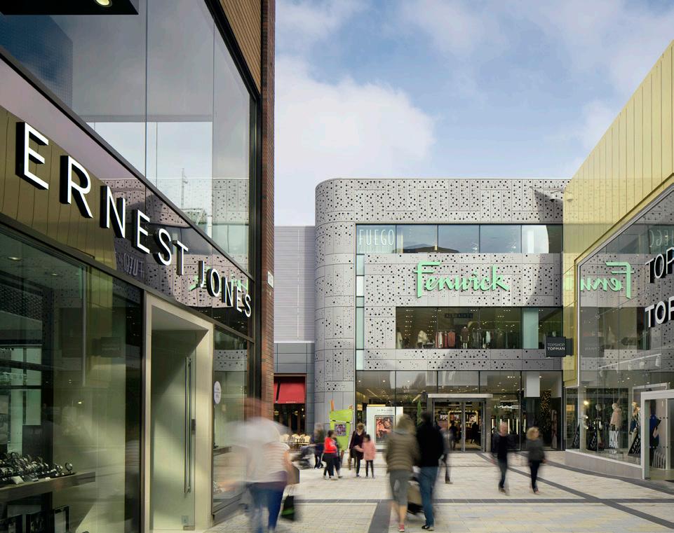
The masterplan that was developed sought to repair the problems of the past with a tried-and-tested typology based on streets and spaces, rebelling against the stereotypical internalised mall that had previously been proposed. The result was a softened, naturalised, and welcoming environment with generous landscaping and living walls. The scale of transformation was ground-breaking, with around two thirds of buildings demolished and re-envisioned. Through the variety of building design, street character, and improved sightlines, the town centre is now highly permeable and inherently legible. The lexicon has genuine credentials as a ‘powerhouse’ retail destination in the region as an integrated town centre with real destinations and connectivity. It is a wonderful place to spend time. Perceptions are changed forever; the greening concept that seeks to emphasise and introduce the surrounding forest and green landscapes in the lexicon contrast with the harsh environment of Bracknell before.
The lexicon is a next-generation shopping and leisure destination that forms part of Bracknell’s large-scale regeneration scheme. It brings to the area new department stores, retail units, restaurants, a 10-screen cinema, 92 apartments, civic squares, open streets, and soft green landscaped spaces. These are all connected in a pedestrian-friendly environment.

A key concept for the scheme and public realm design has been ‘the greening of Bracknell’. It is the first post-war New Town to be comprehensively demolished and rebuilt. As a result, Bracknell’s existing character has been transformed.

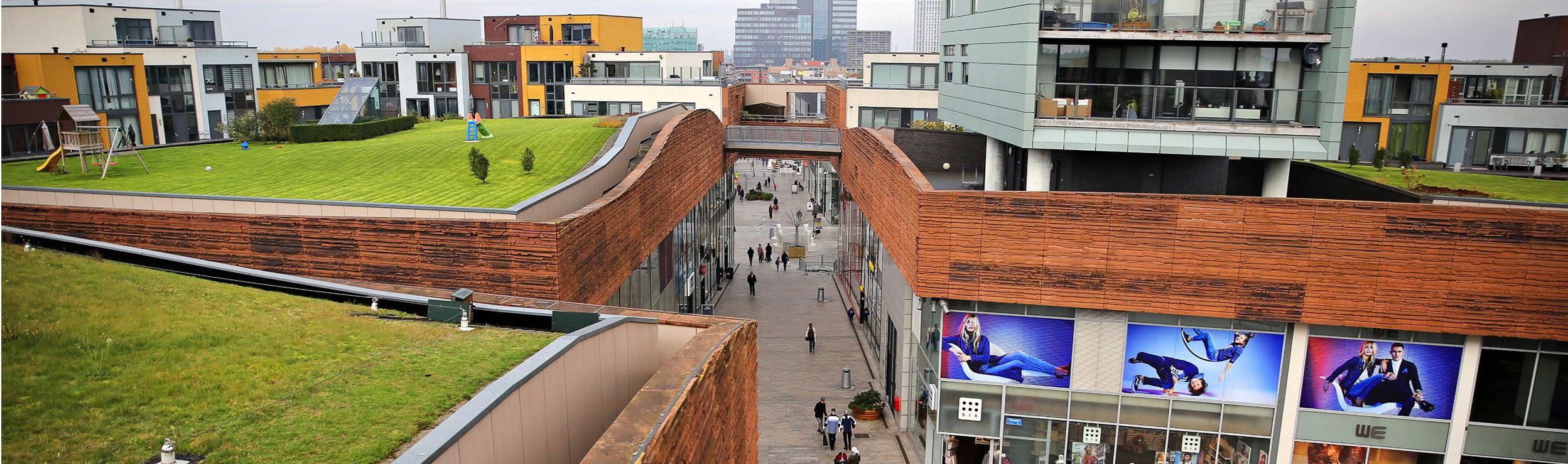
The Lexicon. Original layout (left) and proposed masterplan (right)


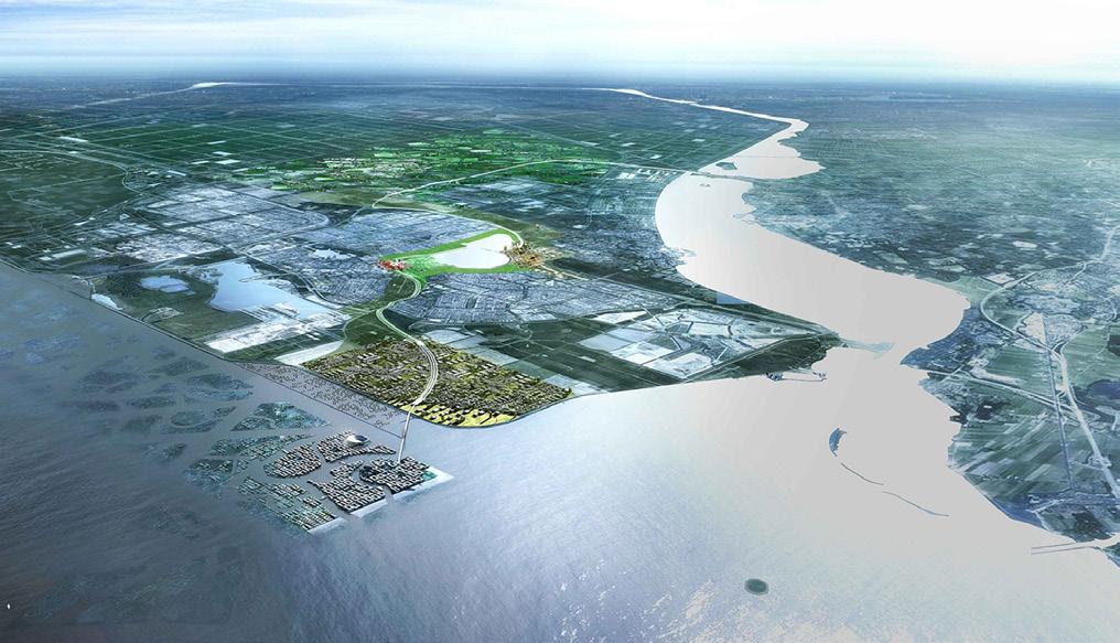
Almere is one of Europe’s largest new towns, and currently the fastest growing municipality in the Netherlands. Built on reclaimed land to the northeast of Amsterdam (Southern Flevoland) during the early 1970s, it was planned in response to housing shortages in the Western Region of the Netherlands. located near Amsterdam and Schiphol Airport, it was originally envisaged as a series of suburban housing clusters with a common town centre (Almere Stad).
The municipality of Almere is reimagining its future growth and transformation. The current population of 175,000 inhabitants is expected to grow to 300,000 under the Almere 2030 Masterplan. An innovative planning approach, based on cradle-to-cradle principles, is guided by the Almere Principles to structure an environmentally, socially and economically sustainable growth strategy. A key aspect of the strategy is the drive to change established relationships between citizens and governments, providing mechanisms for a more active involvement of the former in decision making. As a ‘laboratory for deregulation’, Almere will focus on a process-driven approach that can learn from and adapt to changing conditions.
Almere’s town centre, originally planned for a population of around 80,000 with a generally low income, provided around 40,000 m² of retail. In 1999, OMA drew up a masterplan to invigorate it, focusing on the development of two sites: a new business hub with 130,000 m² of office space adjacent to the train station, and a mixed-use cluster located between the Town hall and the Weerwater. The two developments created a recognisable urban form with a marked contrast with the low density of the old town centre.
The proposed extension for the town centre will be developed across the Weerwater. Its starting point will be the World horticultural Exhibition Floriade 2022, which has been planned as a flexible framework that will structure the transition into an innovative urban landscape that integrates a rich range of natural environments. key design principles that can be used as a reference for Shannon Town Centre include:
Almere, The Netherlands
Almere 2030 view
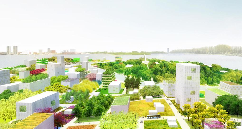
Almere Floriade 2022
• Providing a range of diversified facilities and functions in proximity to each other to create a ‘complete’ urban environment. Using the reference of medieval cities, the urban design combines a range of uses, spaces and typologies that allow to support day and evening uses.
• Creating an organic structure of spaces with continually changing vistas.
• Using a rich palette of materials that contrast with the generalised use of brick in the neighbouring housing developments.
• Segregating cars from pedestrians, combining excellent accessibility with a compact network of car-free spaces.
• Capitalising on the waterfront location to develop key cultural uses and high end residential towers.
• Using the masterplan to coordinate the collaborative work between the municipality, investors, developers and other stakeholders.

Almere Town Centre — Masterplan Almere Town Centre — View of outdoor spaces
Almere Town Centre — Centrum


