3 minute read
3. Environmental setting


This section of the AQ DWP describes the environment surrounding the enabling works site in terms of meteorological influences on the transport of air contaminants and sensitivity of adjacent activities to those discharges.
3.1 Site
The Mt Eden Enabling Works are being undertaken in the vicinity of the existing Mt Eden Station, which is an existing urban environment. The Project area is generally bounded by the NAL (south), Ngahura Street (west), Mt Eden Road (east) and Nikau Street (north), and is bisected by Shaddock Street. The area around the intersection of Porters Avenue / Haultain Street / Wynyard Road and along Fenton Street is also included in the Project area (“the Site”).
Adjacent land uses comprise a range of commercial residential and recreational activities. Due to the density of development and human occupation in surrounding areas the sensitivity of the local environment to air pollution in general is relatively high.
3.2 Meteorology
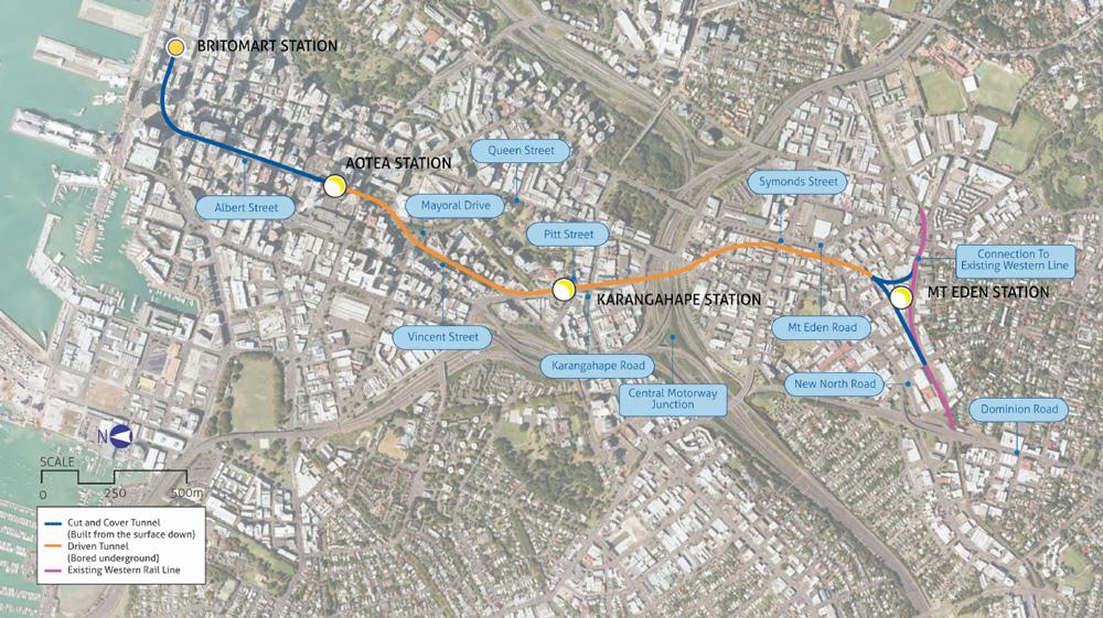
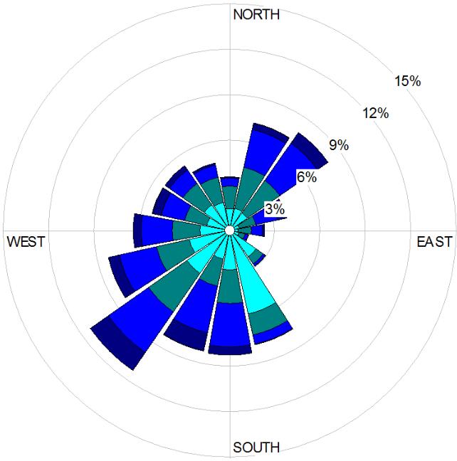
Figure 3-1 shows wind roses of wind speeds and directions measured at the Niwa weather station at the Auckland Museum of Transport and Technology (MOTAT), Western Springs over year round, summer (December to February) and winter (June to August) periods.
The weather station is located approximately 2.85 km to the west of the CRL Mt Eden site. Wind measurements at this station are likely to be generally representative of conditions over the Auckland isthmus as it is relatively free from nearby obstructions or eddies created by adjacent buildings.
Although localised topographical features and adjacent buildings at the Mt Eden site are likely to alter wind conditions, the wind direction frequency trends illustrated below are likely to be broadly similar to those experienced at the Site.
Based on the wind roses in Figure 3-1, winds are predominantly from the southwest and northeast, and therefore sensitive locations to the northeast and southwest of the site, respectively, are likely to be most frequently exposed to any off-site dust emissions from site activities. The amount of dust generated also largely depends on whether conditions are dry, and the wind speeds, with faster wind speeds increasing effect of wind erosion and the distance that the dust travels.
Winter months, 2016-2019, Calms = 6.28% Summer months, 2016-2019, Calms = 2.25%
Figure 3-1: Wind rose frequency analyses of wind speeds and directions at the Auckland MOTATweather station for August 2016 to August 2019, year round, winter and summer months. Source: NIWA Cliflo database.

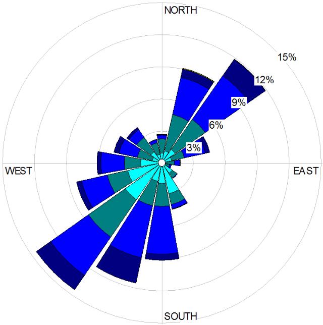
Figure 3-2 shows that the expected drier months are during summer, when wind speeds also tend to be higher. Summer winds are dominated by a south-westerly wind which will transport any emitted dust towards sensitive receptors to the northeast of site.
Figure 3-2: Percentage of wet days (rain exceeding 1 mm) over each month of the year at MOTAT. Source: NIWA Cliflo database.
3.3 Sensitive receptors
The Site is located in a mixed business zone adjacent to Mt Eden Station and features a range of adjacent activities, including activities sensitive to air pollution.
Nearby activities that may be sensitive to dust and other air contaminants include:
Residential apartments on Flower Street, Nikau Street, Fenton Street, Ngahura Street, Korari Street and Akiraho Street. Residential houses along Akiraho Street, Ruru Street and Sylvan Street. The Early Childcare Centre at the western end of Akiraho Street. Pedestrian access (to offices and other places of work) and parked vehicles along long roads. Bars and restaurants, particularly where premises include outdoor dining or entertainment areas. Retail, office and commercial premises. Cityside Baptist Church, Mt Eden Road.
The location of activities located within 100 m of the works area is shown in Figure 3-3.
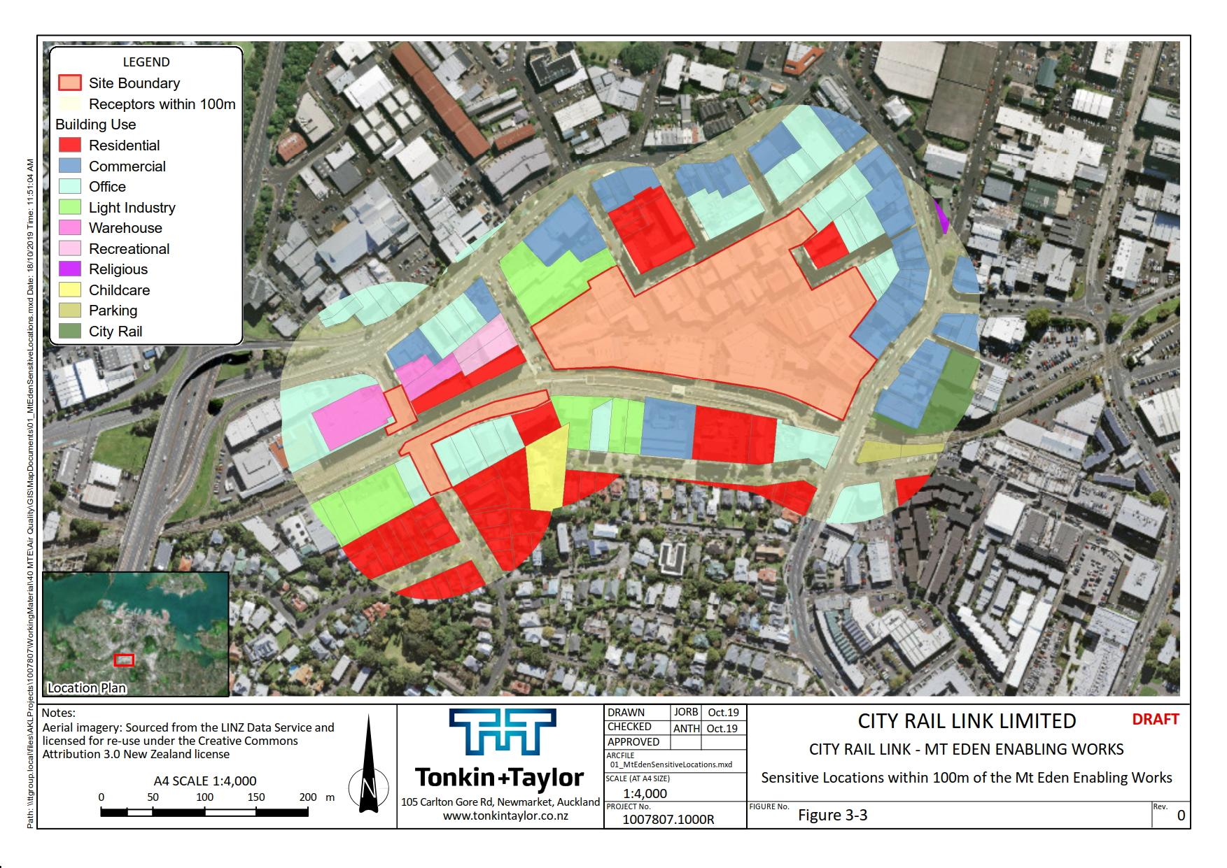
Figure 3-3: Adjacent land use activities within 100 m of the site boundary.
Page 17 | Mt Eden Enabling Works