1 minute read
Neighbourhood Profiles


Check out Neighbourhood Profiles
Take a virtual tour of the city with our new web feature
Advertisement
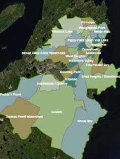
The City is proud to have launched a new mapping and neighbourhood profile feature at map.stjohns.ca/neighbourhoods
The new web application divides the city into 28 distinct areas, or “neighbourhoods,” that are defined by their history, landscape, and unique cultural heritage.
Each neighbourhood profile includes pictures of the area, historical information and points of interest as well as a map to nine key areas of interest, including recreation and sport opportunities, places of faith, health facilities and schools.
“Neighbourhoods are the building blocks of our city,” said Councillor Jamie Korab, Council lead for Community Services. “St. John's is a welcoming and diverse community with an abundance of amenities, programs and services and we are proud to highlight these through this new webpage.”
Defining broad, neighbourhood boundaries does not diminish the importance of wards or existing neighbourhood identification. For example, a local, well-established neighbourhood like Georgestown is included within the larger neighbourhood profile of Rennie’s River, and some wards cross through multiple neighbourhood profiles.
These new boundaries will be used internally to gather evidence for planning, decision making and service evaluation for both staff and council. They will also assist local community agencies with program planning, development and implementation to increase the efficacy of services.
“We believe this new web feature will be useful to newcomers, community organizations, businesses, tourists and current residents who want to learn more about areas in which they want to live, work and play,” said Councillor Korab. “We plan to grow this page over time to include additional community features and link with our Neighbourhood Watch and other community programs.”