2 minute read
Cycle Circles around Salisbury

This is your sign to get pedaling along some of Salisbury’s stellar cycling trails.
Whether you like to do it in style wearing a jersey and lycra – or take it easy in casual wear – there so much to explore in our City on a bike.
Advertisement
We’re so lucky to have plenty of self-guided trails and our social group Cycle Salisbury, for those looking to meet other bike-loving people and tick off the trails on our 103km network.
Self-guided tours
Cobbler Creek
There are multiple trails within Cobbler Creek Recreation Park. Within the City of Salisbury, the Cobbler Creek trail runs from Salisbury Heights within the Cobbler Creek corridor, just below Bridge Road to Main North Road. Riders can follow trails within the Cobbler Creek Recreation Park that take you to roads within Salisbury Heights heading west, and link into the Little Para River Trail. Dry Creek
The Dry Creek Trail runs through the City of Salisbury from Down Drive at Valley View, through Walkley Heights, Pooraka and Mawson Lakes to Globe Derby. There are off road crossings at Briens Road, Main North Road and Port Wakefield Road, and the railway line at Mawson Lakes. There is also a short on-road section at Pratt Avenue, Pooraka. The Dry Creek Trail connects to the Little Para River Trail behind Globe Derby. Please note that the cycling/ pedestrian underpass at Port Wakefield Road/Globe Derby is affected by tides. An underpass (dry weather only) has been constructed under Montague and Main North Road, Pooraka allowing for a continuation along the trail rather than negotiating two road crossings.
Cycle circles around Salisbury
The Little Para River Trail
The Little Para River Trail is the most significant trail in the City of Salisbury. It takes riders on a mainly flat 12km trail (apart from a short on-road detour at Porter Street) from Carisbrooke Park (next to Main North Road) beyond Port Wakefield Road and links with the Tapa Marinthi Yala shared use path.
Tapa Marinthi Yala
The Tapa Martinthi Yala shared use path follows the Northern Connector motorway, between The Northern Expressway (from Gawler) in the north to the South Rd, Port River Expressway Interchange in the south. It links to the Stuart O’Grady Bikeway (North) and Port River Bikeway (South).
This is a significant piece of shared-use infrastructure, offering both walkers and cyclists a long-distance option that is safe for active transport users with key destinations at both ends.
For more information on walking and cycling trails in your area visit discoversalisbury.com.au/trails Find maps and brochures for each of these trails on the City of Salisbury website – salisbury.sa.gov.au/cyclesalisbury
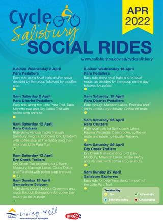
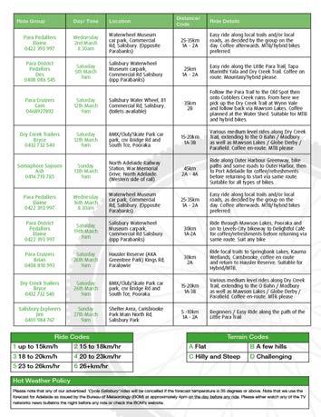
Social cycling
You can register to receive a monthly ride listing automatically by emailing Jim Binder at jbinder@salisbury.sa.gov.au or call 0401 984 767. Each month, the Cycle Salisbury group publish a wide range of FREE tours – both short and long excursions – throughout our stunning trail network. See the latest ride listing on the City of Salisbury website - salisbury.sa.gov.au/cyclesalisbury