2 minute read
DATA AND OBSERVATIONS


Th e “Neighborhood Snapshot” document, available as an appendix to this plan, was prepared following a review of available census and city data to provide an overview of the Dearington neighborhood. Th is section highlights specifi c data and observations that play a role in the recommendations contained in this document.
RECREATIONAL AMENITIES
Within Neighborhood Dearington Elementary School for Innovation (DESI), Jeff erson Park, and the Dearington Apartment’s playground provide recreational destinations within the neighborhood. Outside Neighborhood Nearby recreational amenities include Miller Park, E.C. Glass High School, and Old City Cemetery. However, these can be hard to reach without vehicular access.
Trails Trail access include the Jeff erson Park earthen trail that ties Jeff erson Park to the City’s larger trail network and the Kemper Street paved trail with access a half mile away despite running alongside the Dearington neighborhood.

TRANSPORTATION
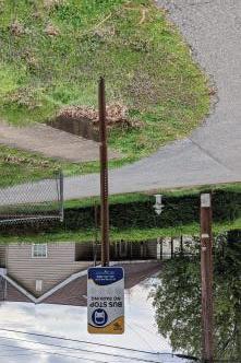
Sidewalks Dearington’s sidewalk infrastructure has severe gaps that limit pedestrian accessibility. Th ere is no route that continuously connects the center part of the neighborhood to either Langhorne Road or Memorial Avenue. GIS data revealed that there are 4.8 miles of sidewalk around the neighborhood, but that there are 5.6 miles of gaps, where there is no sidewalk on either side of the street. In some places topography and narrow right-of-way widths make construction challenging. While Dearington is not alone in experiencing sidewalks that stop and start, the eff ect is also the same – streets and neighborhoods look unfi nished and overlooked. Bus Stops GLTC Route 1 runs in both directions through the middle of the Dearington Neighborhood. It provides a direct connection to Lynchburg General Hospital. Infrastructure at bus stops around the neighborhood varies, much like it does around the City, from having benches and shelters to being as simple as a sign placed in the grass next to the street. Streets Street widths and adjacent topography varies. Stormwater drainage often runs in open channels alongside street pavement. On street parking is also common and informally spans street pavement and adjacent yards. Th ese features, common in older neighborhoods, make the installation of better infrastructure for sidewalks and bus stops more diffi cult and will likely require participation from adjacent property owners to make improvements happen.

Smyth Street sidewalk gaps. Sidewalks stop and start throughout the neighborhood.
Existing Sidewalks

Access to Nearby Destinations Destinations close to Dearington include E.C. Glass High School, Lynchburg General Hospital, Miller Park, the Plaza shopping area, and Fifth Street. Memorial Avenue and Langhorne Road sit at the edges of the Dearington Neighborhood and make using active transportation to reach these nearby destinations diffi cult. Continuous traffi c, inhospitable crossings or a lack of crossing opportunities detracts from the walkability of the area despite a relatively connected streetgrid. Langhorne Road and Memorial Avenue are designated as priority corridors for improvements within our VDOT Construction District; however, further study is needed to better understand the issues and opportunities to perform work here. Page Street provides a connection to Lynchburg General Hospital and other commercial and medical services, but is also precarious as the street is narrow, there is little or no pedestrian infrastructure, and the corridor is often used as a cut-through by vehicles and ambulances.

Looking across Langhorne Road from E.C. Glass High School towards 3rd Street