2 minute read
James MacKay: Chesterfield’s Renaissance Man


By: Ann Chrissos
In the sixteenth century, Leonardo DaVinci epitomized the “Renaissance Man”—he could do many things and he did all of them well. He was a painter, sculptor, inventor, engineer, scientist and architect. James MacKay is Chesterfield’s frontier “Renaissance Man.” He had many skills which were extremely useful in the eighteenth-century Missouri wilderness—he was an intrepid explorer, an accomplished trader, a skilled surveyor, an accurate cartographer, a town promoter, a political leader, a successful landowner and he was also multi-lingual.1 These skills enabled James MacKay to literally and figuratively put the Chesterfield area on the map.
Advertisement
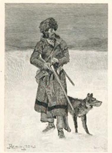
A surviving letter to MacKay’s oldest son outlines the history of his ancestry. He was a descendant of an Irish prince who invaded and settled in northern Scotland five and a half centuries before his birth on May 1, 1761. He was born to Judge George MacKay and his wife, Elizabeth McDonald, in Sutherland County, Scotland, and grew up with three brothers—Robert, George and John—and two sisters—Jean and Catherine. Sometime between 1776 and 1777, MacKay immigrated to Canada where he spent five years exploring, learning the fur trade with various Native American tribes and learning their languages. For the next five years, he signed on with the Hudson Bay and North West Companies as an experienced fur trader, and he explored as far west as the Rocky Mountains. MacKay left Canada in 1788 to visit his brother, John, in New York City and to seek more lucrative opportunities.
Such an opportunity arose when MacKay was asked to lead a trading and surveying expedition to Cahokia, Illinois. He found Cahokia to be a rich fur trading center and a desirable place to settle. Four years later, the lure of adventure pulled him across the Mississippi River and into Missouri territory. The Spanish Lieutenant Governor Xenon Trudeau’s invitation to lead an expedition up the Missouri River for the Missouri Company was too enticing to resist. MacKay hired John Evans as his second-in-command along with cartographer Nicolas de Finiels and surveyor Antoine Pierre Soulard to assist in mapping and naming places along 1,500 miles of the Missouri River. The expedition left St. Louis in late summer of 1795 and returned in the summer of 1797. Spain received a detailed map drawn by MacKay and labeled in French, and Spain paid MacKay with land grants of 3,700 acres near Bonhomme Creek. MacKay then mapped the area with his signature fleurdes-lis at the north arrow, although Nicolas Finiels is frequently given credit for it.
Spain permitted MacKay to form an American village in 1798 near his land holdings. Twenty-nine families—mostly from Kentucky— received land grants along the Missouri River in present day Chesterfield. The village was named San Andre (St. Andrews), and MacKay was appointed commandant. His map illustrated the names and locations of these early settlers. After the 1811 flood, most residents moved their homes up on the bluffs, but continued to plant crops on their river bottoms land. In 1800, MacKay married Elizabeth Long—later known as Isabella Louise—daughter of John and Elizabeth Long. They had three sons —John Zeno, George Anthony and James Bennett—and four daughters—Eliza Lucy, Catherine Mary, Jean Julia and Emilia Anne.
Depiction of a Missouri fur trader.