8 minute read
Recommendations for Reducing Traffic Congestion during Evacuation


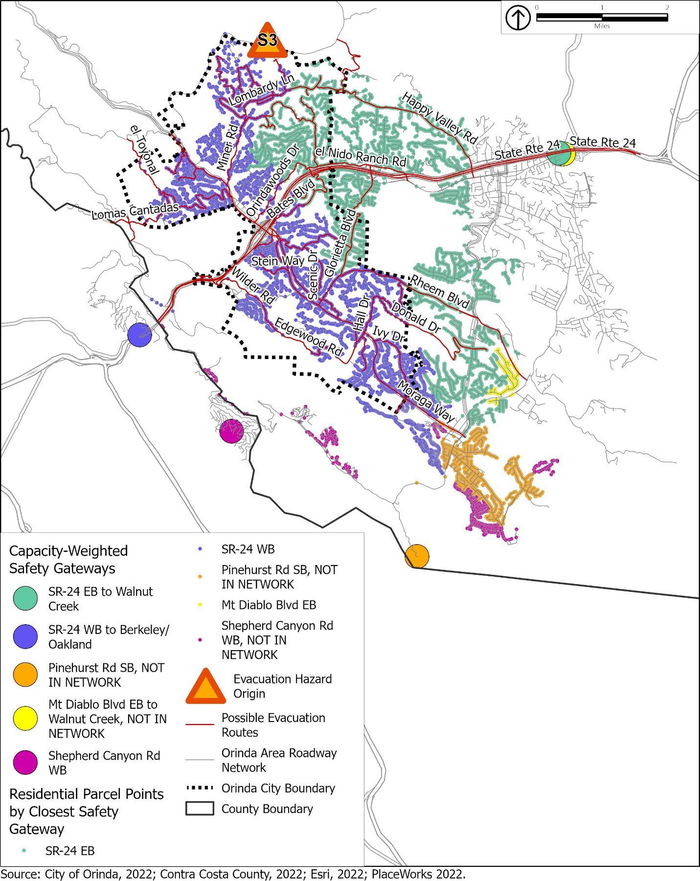
Camino Pablo and Moraga Way are the only arterial roadways in Orinda that lead to SR-24 on-ramps, so most traffic bound for SR-24 ultimately travels along these routes.
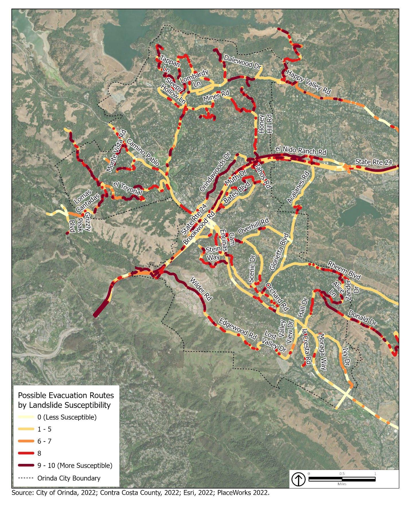
The City of Orinda has already implemented contra-flow lanes on Miner Road, which convert northbound lanes into additional southbound lanes towards SR-24 during an evacuation event. The City has also implemented Red Flag Day parking restrictions along several key evacuation routes, including along El Toyonal and other areas north of SR-24. During Red Flag Days, on-street parking and stopping is prohibited to keep roadways clear for potential evacuation and fire vehicle access. The National Weather Service may declare a Red Flag Day, indicating a high risk of wildfires, given humidity levels, wind speeds, and the possibility of dry lightning. MOFD may also declare a Red Flag Day under similarly dangerous conditions.
Orinda could expand red flag parking restrictions to other corridors in evacuation-constrained areas and establish contra-flow lanes and signal timing measures on existing and recommended Red Flag Day corridors. However, while implementing contra-flow lanes and signal timing preferences is likely to significantly ease congestion along major arterials leading to SR-24 on-ramps by doubling their capacity in the direction of evacuation, the on ramps themselves still merge into one lane without shoulders or signal timing infrastructure, which is likely to create bottlenecks even if arterials leading to the on-ramps have contra flow lanes. This report recommends that Orinda staff coordinate with Caltrans to study the feasibility of implementing potential capital improvements to the SR-24 westbound on-ramps from Camino Pablo northbound and Southbound, like signal timing infrastructure, that could improve the flow of traffic at these on-ramps.
The following recommendations address expected congestion along Moraga Way in the northwestbound direction towards the SR-24 on-ramps: 1. Consider expanding Red Flag Day parking restrictions to include Moraga Way between Ivy Drive and Camino Pablo, and from Camino Pablo northwest-bound to SR-24 westbound on-ramps. 2. In addition to parking restrictions on the segment of Moraga Way between Ivy Drive and Camino Pablo, study the feasibility of implementing contra-flow lanes that convert the southeast-bound lane on Moraga Way into an additional northwest-bound lane towards SR-24 during an evacuation. 3. Consider implementing an evacuation signal timing plan for the following intersections along Moraga Way and the segment of Camino Pablo south of SR-24 to allow only the northwestbound through direction as well as turning movements onto Moraga Way and Camino Pablo northwest-bound to SR-24: − Brookwood Road/ Camino Pablo − Moraga Way/ Camino Pablo − Glorietta Boulevard/ Moraga Way − El Camino Moraga/ Moraga Way − Coral Drive/ Moraga Way − Ivy Drive/ Moraga Way
In addition, the City could also deploy staff to direct traffic at the above key intersections during an evacuation event, or use automated signals as feasible. 1. There are two Emergency Vehicle Access (EVA) roads, otherwise known as fire roads, that connect Moraga Way with Wilder Road, and that could be studied for residential access during an evacuation event to relieve traffic pressure along Moraga Way northbound towards SR-24. The northern of these two EVAs connects Brookside Road (at the intersection with Sunrise Hill Road) with Boeger Ranch Road, and the southern of the two EVAs connects Edgewood Road to the southern end of Wilder Road. This report recommends that Orinda staff, in coordination with MOFD, study the feasibility of using both EVAs for residential use during an evacuation to relieve expected traffic pressure on Moraga Way towards SR-24. MOFD has noted that the Edgewood Road/Wilder Road EVA may require significant improvements to safely support residential use during an evacuation, such as grading, paving, and traffic controls, whereas the Brookside Road/Boeger Ranch Road EVA would only require gate removal at the time of evacuation. Any plans to convert EVAs to public access during an evacuation would require coordination with MOFD to ensure staff provide emergency vehicles with priority access to these routes as necessary before making them publicly accessible. 2. Consider entering into an agreement with unincorporated county, and any other stakeholders to implement contra-flow lanes along San Pablo Dam Road in the northbound direction from Bear Creek Road to the intersection with Valley View Road in El Sobrante. 3. Consider entering into an agreement with Caltrans and other stakeholders to implement contra-flow lanes in the westbound direction along the reversible lanes available on SR-24 in the event of a wildfire in the MOFD jurisdiction.
Orinda has already established or intends to establish red flag parking restrictions on Miner Road and parts of Camino Pablo southbound towards SR-24 from Miner Road. The following recommendations could help provide additional traffic congestion relief along this corridor north of SR-24 during an evacuation:
1. In addition to the contra-flow lanes already established along Miner Road, consider also implementing contra-flow lanes on Camino Pablo from Miner Road to the SR-24 on-ramps, converting the northbound lanes into additional southbound lanes during an evacuation. 2. Consider implementing an evacuation signal timing plan for the following intersections along
Camino Pablo to allow only the southbound through direction as well as turning movements onto Camino Pablo southbound:
− Miner/ Camino Pablo − El Toyonal/ Orinda Way/ Camino Pablo − Camino Sobrante/ Camino Pablo − Orinda Way/ Altarinda/ Santa Maria − Santa Maria/ Camino Pablo
3. There is an additional EVA connecting the northern segment of El Toyonal with Wildcat Canyon
Road. This report recommends that Orinda staff coordinate with MOFD to make necessary roadway improvements to this segment of El Toyonal, like bridge upgrades and gate removal, that would make this roadway accessible for public access during an evacuation. This additional access route could enable more residents in the El Toyonal neighborhood to evacuate via
Wildcat Canyon Road and potentially relieve additional congestion pressure along Camino
Pablo southbound towards SR-24.
In addition to the location-specific recommendations above, this report also offers recommendations for improving general traffic flow for all vehicles traveling out of Orinda during a citywide evacuation:
1. Encourage all residents on the east side of Moraga Way (e.g., with mailers or electronic notifications) to be prepared to check traffic (on Google Maps, Apple Maps, Waze, or other mobile direction application) for both directions along SR-24 during an evacuation event.
Residents could enter ‘Walnut Creek’ as their destination and view the routing, travel time, and traffic estimates for the eastbound direction, and then entering ‘BART Rockridge’ or other equivalent destination to compare conditions in the westbound direction. 2. Consider expanding emergency plans to use dynamic signage (e.g., digital screens at bus stops or along major arterials) that can be used to display messages during an evacuation event directing traffic to alternative routes. Currently, dynamic signage is recommended on Miner
Road. For example, a dynamic sign could be deployed at Valley View Drive and Moraga Way encouraging evacuees to use Valley View Drive to Edgewood Fire Road towards SR-24 westbound. Dynamic signage can be temporary and deployed only during the time of evacuation.
In addition to potential congestion reduction measures listed above, recommendations listed below potentially reduce the overall number of vehicles evacuating during a citywide evacuation event.
1. Consider implementing a plan for coordinated car/van/or bus pool evacuation procedures for
Miramonte Gardens and other larger multifamily housing developments, especially that are evacuating via Moraga Way in the northwest-bound direction towards SR-24 westbound onramps. 2. Coordinate with MOFD to develop fire safe standards as part of the Fire Code for new residential developments in constrained residential areas, such that sheltering in place is a viable alternative plan if evacuation routes become too congested to preclude timely evacuation during an emergency or if other circumstances prevent evacuation, as sheltering in place should only be considered if evacuation is not feasible. Housing Element Opportunity
Sites in relatively constrained residential areas (based on their constraint index score) are shown in Figures 14, 15, and 16 and discussed in further detail in the subsection discussing.
Design and building requirements related to fire safety are discussed in Chapter 14.4 of the
Orinda General Plan EIR, which designates the J&J Ranch and Wilder residential developments as Shelter-in-Place locations based on these standards. Shelter in Place communities are defined in the EIR as ‘entire community or subdivision designed to withstand heat and flames from an approaching wildfire’.
3. Consider using Orinda Community Center as a potential emergency shelter location, which is also northwest of the SR-24 westbound on-ramps from Camino Pablo northwest-bound. If the west-bound on-ramps to SR-24 from Camino Pablo are severely congested, evacuees can alternatively continue straight and head to the Orinda Community Center. 4. Develop evacuation plan with BART to evacuate workers in the Downtown area. Include potential measures for deploying traffic control personnel in the Orinda BART station area and surrounding intersections to coordinate evacuee transfer to BART stations. Also consider coordinating with commercial property owners near Orinda BART to use parking lots for additional BART parking and disseminate public safety awareness campaigns that encourage
Orinda residents to make an alternative plan to evacuate via BART. 5. Consider adopting a phased evacuation approach, using Zonehaven or other applicable tools, that prioritizes improving accessibility along Moraga Way in the northwest-bound direction particularly for residents living in southeast Orinda south of Hall Drive.
In addition to these recommendations for arterial intersections, Table 3 below lists more minor collector intersections that could be potentially constrained, with 100 or more vehicles traveling through them during the first phases of evacuation as residents exit their homes. Table 3 describes each intersection, the estimated vehicle count based on the sum of closest households, and associated recommendations for alleviating traffic congestion at these intersections.
Any roadway segment recommended for contra-flow lanes in Table 3 should also be considered for expansion of red flag parking restriction days other than where Red Flag Day parking restrictions are implemented already. Current red flag parking restricted areas include Loma Vista Drive and El Toyonal between Camino Pablo and Vista Orinda in the northeast El Toyonal neighborhood of Orinda.