20 minute read
AUTOMATED UAS AEROMAGNETIC SURVEYS TO DETECT MBRL UNEXPLODED ORDNANCE


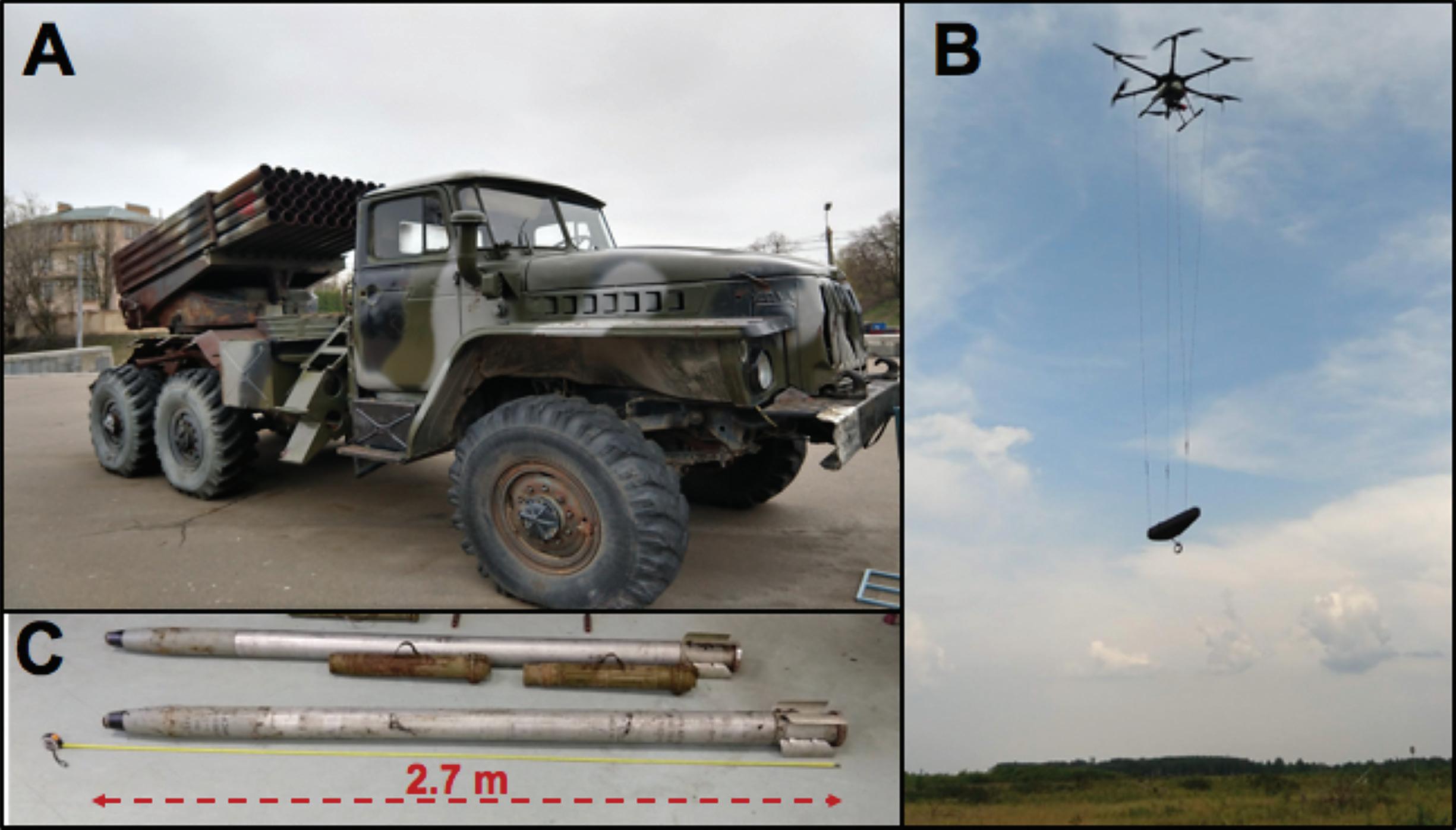
Figure 1. (A) BM-21 MBRL on a truck platform. (B) UMT Cicada-M hybrid UAV hexacopter platform equipped with a suspended Geometrics MFAM magnetometer in a UMT MagPike protective case. (C) BM-21 122 mm rocket with indicated length dimension in red. All figures courtesy of the authors.
By Alex Nikulin*, Ph.D., Timothy S. de Smet*, Ph.D., Andrii Puliaiev**, Vasyl Zhurakhov***, Sofia Fasullo*, Gabriel Chen*, Isaac Spiegel*, and Kaylee Cappuccio* [ *Binghamton University - The State University of New York ], **[ Ukrainian Multirotor Technologies ], ***[ State Science Research Institute of Armament and Military Technology Testing and Certification ]
Advertisement
Unguided Multiple Barrel Rocket Launcher (MBRL) systems are limited-accuracy, high-impact artillery systems meant to deliver barrages of explosive warheads across a wide area of attack. High rates of failure of MBRL rockets on impact and their wide area of ballistic dispersion result in a long-term unexploded ordnance (UXO) concern across large areas where these systems have been deployed. We field tested a newly-developed UAV (unmanned aerial vehicle)-based aeromagnetic platform to remotely detect and identify unexploded 122 mm rockets of the widely-used BM-21 MBRL. We developed an algorithm that allows near real-time analysis, mapping, and interpretations of magnetic datasets in the field and, as a result, rapid identification of anomalies associated with both surfaced and buried MBRL items of UXO. We tested a number of sensor configurations and calibrated the system for optimal signal-to-noise data acquisition over varying site types and in varying environmental conditions. The use of automated surveying allowed us to significantly constrain the search area for UXO removal or in-place destruction. The results of our field trials conclusively demonstrated that implementation of this geophysical system significantly reduces labor and time costs associated with technical assessment of UXO-contaminated sites in post-conflict regions.
INTRODUCTION
Self-propelled MBRL systems have become a familiar sight on the modern battlefields since their widespread use and adaptation during the Second World War. Their ability to deliver a massive barrage of high-explosive rockets over a wide target area and quickly change firing position to avoid counter-battery fire has largely driven their continued use across conflict regions.1 Perhaps the most widely recognized MBRL is the Soviet-designed BM-21 Grad (Hail), capable of firing forty 122 mm rockets in less than a minute (Figure 1A). Since its introduction into service nearly five decades ago, this system has become the most widely used artillery system in the world.2 Despite their widespread use and perceived effectiveness as a weapon of war, the BM-21 and similar systems are notorious for their relatively low accuracy and high rates of ammunition failure on impact. Specifically, available estimates suggest that MBRL rounds fail to detonate at a rate of about 15 percent,3 and, depending on the state of ammunition and soil characteristics of the impact site, the “dud rate” may exceed 30 percent.4 A combination of MBRL systems’ high failure rate and large target areas generates a particularly difficult UXO scenario, where UXO contamination occurs over a wide area, the dimensions of which are determined by the ballistic trajectory of the MBRL barrage.
In the specific scenario of MBRL-generated UXO, the need for rapid wide-area assessment of UXO presence is particularly important. Traditional methods of UXO detection and remediation are largely inapplicable. Demining surveys based on electromagnetic principles can easily locate the largely metallic MBRL UXO, yet the costs of these surveys over wide areas are largely prohibitive in post-conflict developing countries. Additionally, MBRL rounds may impact the soil at a high angle, penetrating the ground and burying the UXO at a depth beyond the effective range of EMI systems, further complicating their detection and identification. Finally, because contaminated areas inherently contain a mix of MBRL UXO items and fragments of exploded MBRL rounds, large amounts of small metallic debris greatly increase the rate of false flags and further slow the process of wide-area UXO remediation. Attempts to complement or substitute terrestrial time-domain electromagnetics (TDEM) and TFM surveys with other geophysical methods targeting wide-area UXO detection and classification had limited success. Seismic and acoustic methods, as well as surveys focused on gravimetry have had limited applicability and have largely been discarded as viable methodologies of landmine/ UXO detection and classification. 10 Likewise, ground penetrating radar (GPR) surveys have found limited use in large-area UXO surveys, with direct applicability only in small-scale UXO discrimination and identification surveys. 11
We present results of a proof-of-concept study focused on developing and field testing a wide-area, UAV-based aeromagnetic survey system to detect unexploded BM-21 122 mm rockets that could be applied to similar and larger-caliber MBRL UXO. Our results indicate that characteristic magnetic anomalies associated with the 122 mm metal casing of the BM-21 MBRL rounds (Figure 1B) register considerably above background levels, both at the surface and up to 10 m aboveground elevation. We further determine that a detection altitude of 3 m is optimal in terms of avoiding low vegetation interference, naturally filtering out clutter noise, while recording meaningful magnetic data at an optimal signal-to-noise ratio. Finally, we demonstrate that this method allows us to distinguish between exploded and unexploded BM-21 rounds, allowing us to direct and prioritize UXO clearance efforts.
UAV-BASED MAGNETIC SURVEY SYSTEM
Advances in UAV technology coupled with successful efforts to miniaturize TFMs allow for a unique opportunity to test a UAV-mounted system for wide-area, high-resolution magnetic surveys targeting UXO detection. Driving this development is the recent commercial availability of lightweight, low-power consumption, laser-pumped atomic TFMs, 12,13 which record the precession frequency of atoms in a magnetic field. An atom’s magnetic moment processes around the magnetic field vector, with a frequency proportional to the magnetic field being measured. Atomic precession frequency and, by extension, the magnetic field may be determined to very high precision and sensitivity (pT). Critically, TFMs, such as the recently-released Micro- Fabricated Atomic Magnetometer (MFAM) by Geometrics, record magnetic field magnitude and, unlike vector magnetometers, provide measurements largely insensitive to orientation and vibration. This allows TFMs to be used in aerial geophysical object search surveys, and their small mass allows them to be mounted on commerciallyavailable multirotor UAV platforms. 14
In parallel with magnetometer sensor miniaturization, commercial multirotor UAVs have become a common sight in recent years. However, most multirotor UAVs remain powered by lithium-ion (LiI) and lithium-polymer (LiPo) batteries, which—due to their weight— provide a restriction on both payload and flight time. Currently, the average flight time for a commercially available hexacopter, with a payload of less than 3 kg, ranges from 15 to 25 minutes, and this time further drops in colder temperatures of operation. This flight duration, while largely acceptable for dense surveying of a confined area, 15 or coarse scanning over a wide area, 16 is prohibitive when wide-area, high-precision scanning is required. Critically, in applications related to landmine/UXO detection, densely-spaced, low-altitude magnetic surveys are needed to provide sufficient sampling to allow for analysis of relatively small metallic objects.
One solution to extend UAV survey time is the use of a hybrid UAV power module with a gas-powered engine powering an electric generator that provides uninterrupted electric power to the UAV. For this study, we relied on the hybrid gas-electric UMT Cicada-M hexacopter (Figure 1C), manufactured by Ukrainian Multirotor Technologies. Due to the combined 2 kW power module, this UAV is able to stay in the air considerably longer compared to traditional electric drones powered by LiI and LiPo batteries. With a payload of 3 kg, the Cicada-M remains in the air for a maximum flight time of 150 minutes, significantly extending useful survey time needed for highresolution magnetic acquisition. Critically, the Сicada-M is equipped with RTK GPS modules allowing autonomous, low-altitude data collection along densely-spaced grid lines. Increased instrument sensitivity, coupled with low flight altitudes, higher survey density, and extended flight times offered by the hybrid UAV platform allow identification of anthropogenic targets previously only identifiable in ground magnetometer surveys.

Figure 2. Design (A) and results (B) of a vertical magnetic sensitivity test.
We designed an experimental program to address four central questions, all meant to assess the overall viability of using a hybrid UAV- MFAM platform to conduct wide-area magnetic surveying:
1. Is the MFAM impacted by the magnetic field generated by the hybrid engine or UAV rotor operation?
2. What is the vertical sensitivity of the MFAM to a magnetic anomaly generated by an unexploded BM-21 122 mm rocket and what are the optimal survey parameters for wide-area scanning for this type of UXO?
3. How does the spatial orientation the BM-21 UXO and its depth of burial impact its resolvable magnetic signature?
4. Can an intact, unexploded BM-21 122 mm rocket be discerned from metal debris resulting from the detonation of the same projectile in a blind field trial?
We designed a controlled experiment to address each of these questions and present our results in the next section.
CONTROLLED SITE TRIALS
Prior to beginning targeted surveying, it was necessary to establish the sensitivity of the MFAM unit to the magnetic interference fields generated by the operation of the gas-powered engine and powerful electric rotors of the Cicada-M UAV. We proceeded to measure the minimal vertical separation of the MFAM unit, encased in a protective UMT MagPike ballistic foam case, from the UAV base. For this experiment, as well as all subsequent surveys, sensors of the MFAM were oriented in opposing north-south alternating directions, recording the magnetic field gradient to allow for faster in-field processing of the datasets. We determined that depending on the throttle of the engine, magnetic interference from the engine dissipated beyond the limit of detection at vertical separation of 1.7–2.4 m, with 1.7 m correlating to the lowest engine RPM and 2.4 m correlating to the highest RPM allowed by the engine. For all subsequent trials, we used a vertical separation of 4 m, suspending the MFAM acquisition system using three soft non-magnetic cords attached to the propeller beams of the UMT Cicada-M (Figure 2). In all subsequent trials, we did not witness detectable magnetic interference correlating to engine or rotor operations (regardless of throttle levels), allowing us to conclude that a properly-configured hybrid Cicada-M UAV platform is suitable for accurate magnetic surveying.
In the second experiment, we sought to establish the vertical sensitivity of the UAV-mounted MFAM unit to a magnetic anomaly generated by a single, unexploded BM-21 rocket and define optimal surveying parameters to target this type of UXO. For this experiment, we used a 3-m concrete-filled pipe, similar in mass, length, and metal content to a composite BM-21 122 mm rocket, commonly consisting of the projectile and a metal fragmentation coil wrapped onto the inner wall of the round (Figure 2A). The simulated UXO was oriented east-west on a concrete pad away from other similarly-sized metallic objects. The UAV system carrying the attached MFAM unit was manually guided to the center of the simulated UXO and proceeded to rise vertically at a rate of 1 m/s to a total altitude of 34 m above ground. We
present results of the second experiment in Figure 2B, where the horizontal axis represents time and the vertical axis records total magnetic intensity. As anticipated, the magnetic anomaly was most pronounced directly above the simulated UXO, and its intensity dissipated at a geometric progression until fully disappearing at an altitude of about 20 m above ground level (AGL).

Figure 3. Magnetic intensity map of inert simulated UXO in a controlled field trial site with letters on the map matching the position and type of the planted object. These inert munitions included a BM-21 MBRL 122 mm rocket (A), a SA 22 type anti-aircraft missile (B), and a solid metal core 152 mm artillery shell (C).
Following the vertical sensitivity test, we proceeded to conduct a number of additional UAV flights over a controlled area, seeking to determine optimal survey parameters that allow us to highlight the presence of the simulated BM-21 UXO, while filtering out magnetic noise from metallic debris. Experimentally, we determined that at a tethered sensor altitude of 3 m AGL and flight altitude of 7 m AGL, we could achieve the optimal balance between our ability to resolve a simulated BM-21 UXO and limiting false flags from metallic clutter smaller than the test object. Similarly, we determined that survey spacing of 3 m allows us to consistently identify magnetic anomalies associated with the targeted UXO type. Finally, we identified an optimal traverse speed of 3 m/s, which allows us to both provide high sampling density (MFAM samples at 1,000 samples per second, while the GPS time stamp is placed only every second) and aerodynamic stabilization of the MagPike platform in flight. In sum, we arrived at a 3-3-3 formula for UAV-based aeromagnetic acquisition: 3-m sensor elevation, 3-m traverse spacing, and 3-m/s acquisition speed. The speed of acquisition can be further increased up to 10 m/s if the GPS timestamp frequency is increased to match that of MFAM sampling density.
CONTROLLED FIELD TRIALS
Following controlled site testing and optimization of UAV survey parameters in a relatively small contained area, we proceeded to conduct a series of field trials to determine if automated UAV aeromagnetic surveys over larger areas would successfully detect inert MBRL UXO. We conducted initial controlled field trials on the grounds of Chernihiv Airfield installation in northern Ukraine, where a series of inert training UXO were placed at about 25 m intervals along a linear east-west transect. We tested three types of inert munitions: (a) BM-21 MBRL 122 mm rocket, (b) SA 22 type anti-aircraft missile, and (c) solid metal core 152 mm artillery shell. From this configuration, we sought to determine if we could not only effectively detect but also discriminate MBRL UXO items from similarly sized and shaped non-magnetic UXO items and highly-magnetic but significantly smaller 152 mm artillery projectiles. The setup is presented in Figure 3.
UAV surveys were conducted north-south, perpendicular to the transect in the 3-3-3 configuration as identified in the controlled trials. Raw magnetic data were parsed and de-striped with correct GPS time markers (Figure 4A). A simple line-leveling technique was then applied to each of the flight lines for every individual flight. This removed the directional interference in the data. Subsequently, the regional total magnetic field for the controlled site was removed. These values were calculated using the International Geomagnetic Reference Field (IGRF) model. The residual total magnetic intensity was plotted using the Kriging Interpolation to turn the values into rasters and create an image of the data. A low-pass convolution filter was then applied to remove image background noise, and the raster color scale and inversion was adjusted to most effectively intensify the magnetic variation in the data, thus clarifying anomalies that represent UXO items. It was then easier to observe magnetic anomalies with a higher confidence that detected UXO items were not false positive errors.

Figure 4. Magnetic intensity maps over controlled site, with small black dots indicating GPS tracks of the conducted north-south UAV flights in (A). Black letters indicate the anomalies associated with simulated UXO objects (B).
In the processed and mapped datasets, there were three welldefined dipole anomalies: A, B, and C (Figure 4). Anomaly A was associated with the inert BM-21 rocket, anomaly B was associated with the SA-22 inert missile, and anomaly C was associated with the inert metal-core 152 mm artillery projectile. What is immediately obvious is that the largely metal BM-21 (Figure 4A) rocket has a considerably more-intense magnetic signature than a similar-sized and shaped but largely non-magnetic SA-22 inert missile (Figure 4B). Conversely, the metal-core but much smaller 152 mm artillery projectile generated a magnetic intensity anomaly of comparable size to the BM-21 (Figure 4A) rocket.
This result was instructive and helped us calibrate our processing filters to the metal content and size of the BM-21. We also noted that in the presence of massive magnetic UXO items of smaller calibers, there may be false-flag alarms associated with the high magnetic intensity fields generated by such objects. We do note that the inert 152 mm projectile was a solid metal core training projectile without an explosive chamber, which represents a very atypical object to be encountered in the field.
BLIND FIELD TRIALS
Following successful detection of the inert BM-21 rocket in controlled trials, we had a unique opportunity to test the developed survey platform and processing/detection algorithms at a live test site. Specifically, we were presented with an opportunity to survey a small section of the Ukrainian Armed Services Honcharivs’ke MBRL proving grounds. Here, the operators of the grounds identified an area where two MBRL rockets failed to explode on impact—a 220 mm BM-27 Uragan (Hurricane) projectile and a 122 mm BM-21 Grad projectile.
This area allowed safe access via a reinforced concrete road, which served as a staging and take-off area for the UAV. A survey of the live site was conducted using the same 3-3-3 parameters as previously defined, and the dataset was analyzed relying on the same processing and mapping protocols. The results from the blind test surveys of live, unexploded 122 mm rockets are presented in Figure 5. In the magnetic dataset, we observed two large magnetic anomalies (labeled as A and B in Figure 5). In our initial assessment, informed by results of the controlled trials, we hypothesized that the weaker anomaly is associated with the larger-caliber BM-27 rocket, which despite its larger size contains more non-magnetic aluminum in its design. Consequently, we hypothesized that the larger anomaly B is associated with the BM-21 UXO. Our assessment and the geographical coordinates of the anomalies were relayed to the operators of the testing site, who conducted a visual survey in indicated areas. Anomaly A was immediately identified as a BM-27 rocket, which was submerged at a relatively low angle of impact (Figure 5B). As for anomaly B, the assessment took significantly longer, as there were no visible signs of the UXO at the surface; however, upon closer inspection, the search revealed the tail section of a 95 percent submerged BM-21 rocket, as seen in Figure 5. Critically, the BM-21 rocket’s tail section was below ground level and would have been impossible to identify in a wide-area visual survey conducted without constraining the search area.
CONCLUSION
Our results to date indicate that UAV-based high-precision low altitude aeromagnetic surveys can have a transformative impact in wide-area assessment of regions impacted by MBRL-generated UXO contamination. Having performed calibration experiments. controlled surveys, and live field trials, we arrived at a standardized methodology for wide-area surveying specifically targeting detection and identification of the most common 122 mm BM-21 MBRL UXO items. Our blind field trials demonstrated the effectiveness of this system in terms of both assessment accuracy and speed. Critically, we were able to convert aeromagnetic survey datasets to actionable anomaly maps with minimal processing conducted on field-deployed computer systems. Using the current settings of the survey equipment and derived survey air speed and altitude parameters, we can survey27,000 line meters during a single 150 minutes flight of the hybridUAV, allowing surveying of a 600 x 600 m area in approximately 11hours. If, in the future, the sampling rate of the GPS unit is raised to match the sampling frequency of the magnetometer, the survey can be conducted at 10 m/s air speed, and the 600 x 600 m area could be surveyed in 3.5 hours with the same level of accuracy and resulting interpretation confidence.

Figure 5. Total magnetic field data at blind test site, with two anomalies associated with UXO objects marked (A) and (B). The concrete road can also clearly be seen to the south in the bottom of the magnetic map, likely because of a large amount of rebar used in its construction.
Successful application of this methodology may be limited in the presence of tall vegetation and may be influenced by site conditions, including host soil geology, presence of metallic debris, infrastructure, and topography, all of which can impact the depth, angle, and successful identification of buriedUXO. Perhaps most importantly, impacted areas with vegetation over 10m tall will force sensor elevation outside the effective range of the survey system. Large, near-surface natural and anthropogenic magnetic anomalies may cause constructive or destructive interference within the magnetic datasets, complicating initial analysis.Finally, highly-variable topography will require additional consideration and accurate terrain contouring by the UAV to maintain constant sensor elevation above ground level.
In the coming months, we hope to conduct additional full-scale trials to further analyze the optimal UAV platform configuration for data collection in the presence of exploded munitions and magnetic clutter. In a previous study, Butler discussed the importance of accounting for background noise that may clutter the data and make theanomalies less distinct in the study of magnetic backgrounds in UXO detection.17 Our results have been consistent with that of Butler when comparing the noise in seeded and live site data at different heights. Additional inquiry into how various altitudes in terms of distance between magnetic anomalies on the same site affect the optimal height for data collection is also warranted.Additional inquiries should also be focused on the effects of UXO orientation and impact site composition on detection efficiency.
In terms of future development of processing and mapping algorithms, we intend to incorporate additional methods of magnetic noise filtering to improve the resolution of the magnetic dataset. BeyondIGRF, the National Marine Electronics Association (NMEA) GlobalNavigation Satellite System (GNSS) elevation data could be used to parse data, with additional reduction to the pole (RTP) filtering. This workflow could produce a clearer image and extend the distance range at which discernable data is collected. Finally, as this research effort progresses, we anticipate using the large magnetic datasets to develop an automated algorithm that can be used in machine-assisted data processing, mapping, and analysis similar to our previous research on scatterable landmine detection. 18,19 Toward this end, all raw data from these field trials are openly available at the Open Repository ofBinghamton University. 20,21
While our results to date are specific to the Cicada-M UAV platform equipped with the Geometrics MFAM sensor, it can be reasonably concluded that similar results can be achieved with other UAV and sensor platforms with only slight recalibration of survey design and data processing streams. With UAV platforms further improving in reliability, and magnetometers dropping in size and cost, our study demonstrates the potential for cost-efficient aeromagnetic surveys as a key element in wide-area technical assessment of MBRL-generated UXO contaminated areas.
To see article with endnotes see full Journal.
ACKNOWLEDGEMENTS
Our effort would not have been possible without the support of the engineering, flight operations, and analytics specialists of Ukrainian Multirotor Technologies, in particular Pavlo Kosolapkin, Vitalii Gitchenko, and Anton Smirnov. Additionally, we want to acknowledge the contribution of all personnel of the Geneva International Centre for Humanitarian Demining, the Demining Center of Ukraine, the personnel of the State Emergency Service of Ukraine, and the service members of the Armed Forces of Ukraine, who contributed their time and expertise to this research effort. Also, we are grateful to Binghamton University, in particular Megan Fegley with the First-year Research Immersion program, Wendy Neuberger with the Harpur Edge program, and Olga Petrova with the Office of Entrepreneurship & Innovation Partnerships for supporting this research effort. Finally, the research team would like to personally thank Kyiv-based journalist James Brooke and photographer Sergei Loiko for their insight and motivation that helped guide this project.
Alex Nikulin, Ph.D., is an Assistant Professor in the Department of Geological Sciences and Environmental Studies. Professor Nikulin is a co-founder of the Geophysics and Remote Sensing Research Laboratory at Binghamton University, a collaborative academic platform that brings together undergraduate and graduate researchers, faculty from multiple departments of Binghamton University, as well as multiple industry, academic, government, and NGO partners, to work on resolving critical issues facing society through innovative applications of geophysical techniques. His research focuses on the broad field of energy geophysics, with applications in exploration geophysics as well as the emerging field of automated geophysical surveying.
Timothy S. de Smet, Ph.D., is a Research Assistant Professor in the Department of Geological Sciences and Environmental Studies, Director of the Geophysics and Remote Sensing Laboratory, and leader of the Geospatial Remote Sensing/Environmental Visualization with Drones research stream in the First-year Research Immersion at Binghamton University. His areas of expertise are aerial remote sensing and near-surface applied geophysics. Dr. de Smet’s research utilizing frequency and time-domain electromagneticinduction, magnetometry, ground-penetrating radar, and aerial LiDAR and thermal infrared remote sensing has been published in Geophysics, Sedimentary Geology, Archaeological Prospection, Remote Sensing, and The Leading Edge. de Smet is an FAA 107 certified UAS remote pilot.
Andrii Puliaiev is the Chief Executive Director at Ukrainian Multirotor Technologies with extensive experience in UAV design and adaptation in automated geophysical surveys.
Vasyl Zhurakhov is a leading scientist at the State Science Research Institute of Armament and Military Technology Testing and Certification of Ukraine with research experience in applied near surface geophysics and a specialty in electromagnetic induction methods.
Sofia Fasullo, Isaac Spiegel, Gabriel Chen, and Kaylee Cappuccio are students in the Environmental Visualization with Drones research stream in the First-year Research Immersion program at Binghamton University. Sofia Fasullo is a sophomore undergraduate researcher at Binghamton University majoring in computer applications in geography and mathematics. She has been working in the Geophysics and Remote Sensing Laboratory since her first year and is interested in GIS research that focuses on the impact of land development. She is an NSF REU IRES Undergraduate Research Intern with Villanova University working on improved efficiency of demining efforts in Cambodia. Gabriel Chen and Isaac Spiegel are sophomore geophysics majors interested in the application of applied geophysics and remote sensing to environmental problems. Kaylee Cappuccio is a sophomore at Binghamton University majoring in integrative neuroscience. She worked in the Geophysics and Remote Sensing Laboratory for three semesters. She is currently working under Patricia Di Lorenzo, researching electrophysiological taste responses of awake rats.


