12 minute read
Gull’s Eye


ST MARY’S, SCILLY
49’55”04N 006’18”48W Cornwall’s answer to the Caribbean, Scilly is a playground for sailors and St Mary’s its only port. Sam Fortescue pays a visit
APPROACH
You can reach the harbour by going south about or north about the island. The southerly route is strongly recommended for fi rst time visitors as it is less complicated
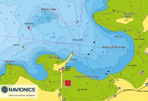
RAT ISLAND THE QUAY

HARBOURMASTERS OFFICE AND FUEL NEWFORD ISLAND
ST MARY’S POOL
SMALL CRAFT MOORINGS
TOWN CENTRE
EW S


Just the name Scilly conjures a magic all of its own. It is a places of crystal clear waters where palms droop and the sun gleams o white sands. And in the sailor’s mind, it is also a treacherous reef that has claimed more ships than any other point around the British coast.
Most notoriously, four ships and 1,450 souls of the returning Gibraltar eet under Admiral Sir Cloudesley Shovell, were lost on the Western Rocks in 1707. “As you y in here it looks stunning from the air – deserted white sandy beaches and piercingly clear seas,” says harbourmaster Dale Clark. “But of course it’s not always like that – something we like to mention to people.” e Isles of Scilly are a collection of ve main inhabited islands and some 140 o ying islets scattered in an archipelago 35 nautical miles west of Penzance. Lying on the same ancient granite outcrop which gives Cornwall its mineral wealth, the islands contrast rocky moorland with pristine sandy beaches and rich farmland. ere is some thought that it formed a single large island as recently as the Roman period, but these days, St Mary’s is the biggest with three-quarters of the 2,153 population of Scilly, plus the airport and ferry terminal.
Each island has its own character. Tresco is the second in size, privately owned and run as a tourism business with holiday lets and cafés. “It is very much a holiday destination for many people,” says Clark. “It’s got a completely di erent feel from St Agnes, which is very much more remote - great for storm watching and can be very rocky.”
St Martin to the north is covered with moorland between rocky granite headlands, “and stretch upon stretch of white sandy beaches”. en there’s St Agnes, the southernmost island, with its wealth of rare plant life and SSSI protection. Bryer sits across a narrow channel from Tresco, with its rocky spine towards the weather. ere is a regular boat service between all the inhabited islands, and the Scillonian III ferry takes 2h45 to make the passage from Penzance. It operates from March to November.
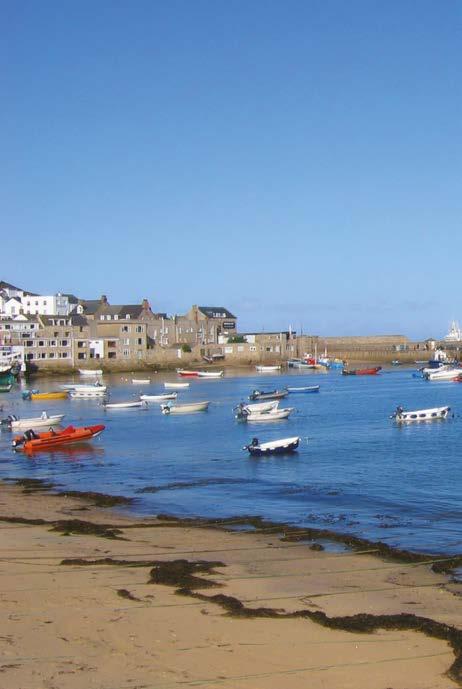
ABOVE
Looking down on the harbour - an excellent haven in most weather
49’55”04N 006’18”48W
HARBOUR GUIDE
While there are no marina berths among the islands, there is an excellent natural harbour on the north side of St Mary’s, the main island. Protected from the southwest round to the northeast, it was further enclosed to the west by the building of a quay out to Rat Island in the 19th Century.
Berthing is entirely on moorings laid by the harbourmaster – some 200 in total. Of these, 38 are earmarked for visiting yachts according to a colour scheme where four rows of yellow balls are suitable for yachts up to 40 and a further 10 green balls for boats from 40-60 . ere’s even a red mooring for up to 80-footers. Visitor moorings are found in St Mary’s Pool, in depths of 0.5-2.0m above chart datum – north of the RNLI station on Carn omas.
It isn’t possible to reserve buoys, even in high season, but harbourmaster Dale Clark advises skippers to ring ahead and check the situation. In high season, expect to ra up alongside another boat – “the visitor’s moorings within the harbour are suitable for ra ing and this is a well recognised procedure, particularly in ne weather,” says Clark. “In the summer its hustle and bustle and a hive of activity.

All the moorings are filled up. Passenger ferry runs 7 days a week.”
The main building on the quay houses four showers, including one that is fully equipped for disabled access. Access to the showers and loos is possible 24 hours a day, but you’ll need to feed the shower meter with £1 coins or tokens purchased from the harbourmaster.
Fuel is available – either in cans or direct to the boat – from Sibley’s in the middle berth along the quay. Depth alongside is 0.5m above chart datum, so take note of the tides as well as opening times: 8-11.30am and then 1-5pm. Water and electricity are also available from the quay – the only place in the islands.
The entire harbour is covered by free wifi – search for the MyWyFy network and follow instructions to log in. Further facilities include general refuse bins, recycling and waste oil disposal.
The pubs, cafés, restaurants and shops of Hugh Town are on the doorstep, including a wellreviewed fish restaurant called On the Quay, which could hardly be nearer to the dinghy pontoon. The nearby Mermaid Inn is “a rite of passage,” and there are supermarkets, bank machine and many other facilities in the town.
Note, there are no lift-out facilities suitable for cruising yachts in the Scilly Isles.
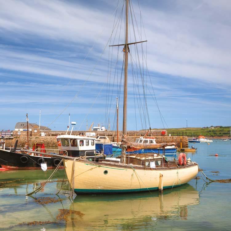
ABOVE LEFT
Looking towards the quay and the harbourmaster’s office
ABOVE RIGHT
A mix of fishing boats and leisure craft shelter behind the quay
FACTFILE
ST MARY’S, SCILLY
Open: 08.00-17.00 weekdays 08.00-12.00 weekends (Apr-Oct) Tel: +44 1720 422 768, +44 7789 273 626 VHF: Ch.14 Email: hm@stmarys-harbour. co.uk Website: stmarys-harbour.co.uk
Facilities:
Swinging moorings up to 80ft LOA Alongside berths up to 60ft LOA Mooring assistance Free wifi Boat and trailer storage Diesel/petrol from fuel berth on quay Cooking gas – Calor/Campingaz Recycling facilities Pump-out Showers and toilets (accessible 24/24 hours) Laundry service from Sibley’s
Berthing fees: Daily mooring:
<40ft (12.19m) £20.50 <60ft (18.30m) £25.50
Daily quayside:
<40ft (12.19m) £25.50 <60ft (18.30m) £30.60 >60ft £41.00
Short-stay (half day):
50 per cent of overnight charge Summer season: (Apr-Oct): <30ft (9.10m) £481>30ft £65/m
Services:
Technical services on the island are limited and there’s no boat lift suitable for yachts, so underwater repairs tend to be carried out against the drying wall between tides. “I’m not sure we’ve ever had a yacht arrive where we haven’t been able to help at all,” says harbourmaster Clark. “People are a pretty dab hand around the islands at getting boats up and running and back home where mainland services can take over.” The chandlery in St Mary’s closed some time ago, but some useful supplies are held by local shipwrights and the Harbour Master is happy for people to order parts in for delivery to the harbour office. Sailmaker: Keith Buchanan at Ratbags +44 1720 422 037 Nike engineering: +44 1720 422 991 Southard Engineering: +44 1720 422 539 Joinery: Peter Martin +44 1720 422972 GRP work: Martin Bond +44 7767 803 908 Electrical: T A Hicks +44 7887 687936
PASSAGE PLANNING


Scilly rightly has a fearsome reputation for navigation. There are rocks and shoals aplenty, so bad weather makes closing the islands or even moving between them a ticklish job. Fortunately, the worst of the hazards lie to the southwest of the islands, from where few cruisers approach.
“There’s a fear factor,” says Clark. “You have to leave Land’s End behind before you pick up Scilly. It’s a bit of a jump for cautious sailors.” That said, the islands have been surveyed again in detail since 2012, and are well lit and marked, so access is possible day and night. And in the settled weather that most visiting yachts will choose for the passage from the mainland, getting in is very straightforward.
St Mary’s will often be the first port of call, and you can reach the harbour by going south about or north about the island. The southerly route is strongly recommended, as it is deeper and clearer of hazards. “Though fairly narrow, it’s well-marked and it’s deep,” says local sailor Jeremy Phillips.
Beware of the drying Gilstone a few cables east of the Peninnis Head light – coming from the mainland keep the light on a clearing bearing of at least 275 degrees. Pick up the easterly cardinal marking the Spanish Ledge and turn onto 307 degrees to slide up St Mary’s Sound between the Woolpack southerly cardinal and the Bartholemew Ledges, marked with a Q.R. 12m buoy. As the N Bartholemew red mark (Fl.R.5s) comes abeam, swing to the northeast onto no more than 27 degrees to run close inshore along Garrison Hill. Leading lights will take you in to The Pool on 97 degrees.
Northabout St Mary’s is a tricky route best done with some local knowledge. You must stick to a series of good transits to avoid offlying rocks and the Crow Bar off the top of the island, whose southernmost tip is awash at chart datum. You’ll have to cross sand with a least depth of 1m of water at lowest astronomical tide. “You need to pay attention to the tidal heights,” confirms Clark. Tidal ranges are moderate – 0.8-5.6m
ABOVE LEFT AND BELOW
The coast of the Scillies is rugged and rock strewn and should be treated with respect
ABOVE RIGHT
A fine view of the harbour illustrating the narrow isthmus at springs and 2.0-4.4m at neaps.
Steer close in by Hats, then shape for Green Island until you identify the deeper water close to the bar. Turn onto 260 degrees and leave the isolated danger mark of Crow Rock to port. By now you’re back in deeper water and can shape a course just west of south to reach St Mary’s. Not one for the hours of darkness.
Approach from the north of Scilly is straightforward. You’ll need to leave Steeple Rock westerly cardinal then Spencer’s Ledge southerly to port and then steer in to St Marys Roads on 077 degrees.
Whichever way you approach the harbour, note that two dangers lie between St Mary’s Roads and The Pool. The Cow to the north is unlit and dries to 0.6m, while Bacon Ledge is just 0.3m below chart datum, and carries a red light in summer months.
Tides around Scilly are always heading somewhere – there is precious little stand so you need to be alert. The flood is oriented northeast, turning southwest for most of the ebb.


CRUISING GROUNDS
Beautiful destinations lie just a short sail away once you’ve made it to the Isles of Scilly
It has been said that the Isles of Scilly would make a magnificent base for the whole summer, particularly with a boat that can take the bottom. But whether you have a long weekend or a whole month, there is a wealth of exploring to be done in the archipelago.
Around St Mary’s itself, there are several alternative anchorages which can provide better shelter when N or W winds are forecast, or for settled weather lunch stops or overnighters. The principal alternative is lovely Porth Cressa, immediately south of Hugh Town, which offers good holding in sand despite the terrifying plait of cables that are laid in through its mouth. Other possibilities include Porth Loggos, Porth Hellick and Watermill Cove.
Another good bet in northerly weather is The Cove between St Agnes and Gugh, although it is open to the wind with just a very low sand causeway connecting the two islands. Ashore, there are cottages and a patchwork of flower fields in the season. There’s a boulder maze that some say hails from Viking times, and beautiful heathland at Wingletang Down. Sample the locally-distilled gin at the island pub - the renowned Turk’s Head.
Three miles north lies Tresco, which is separated from Bryher by the Tresco Flats and New Grimsby Sound. This is a fascinating place – a shifting landscape of rocky islets which becomes one entity connected by glistening sand at low water springs. There are several anchorages, a raft of visitor’s moorings and a renovated quay for those who can dry out. “New Grimsby and Old Grimsby are often better protected from the swell than St Mary’s,” says Jeremy Phillips, who sails a lift-keel Southerly 105.
On Tresco, the New Inn is known for its live music, and there is the famous sub-tropical Abbey Garden. Bryher has the Fraggle Rock pub and takeaway seafood at Island Fish. “Crab and lobster are specialities in all the islands,” says Clark. “There’s no mucking about with the crab shack on Bryher: here’s your bib, here’s your hammer.” Its coast is wild and varied and includes the aptly named Hangman’s Island.
St Martin’s is two miles to the northeast and visitors can snorkel with seals and sip wine from the island’s vineyard. Plus, gig racing on Wednesday and Friday nights. Deserted St Helen’s nearby also offers an very well-sheltered anchorage in good depths.
Naturally, there are a wealth of other anchorages around the uninhabited islets, but you’ll need some tips to find them. “There are always places you can go to escape the summer crowds,” says Phillips. “But it very much depends on the depth of the boat. The electronic charts aren’t really detailed enough for poking in and out of the reefs without local knowledge. To an extent, you can eyeball.”
It is just 28 miles to Land’s End, around 35 to Penzance and perhaps 45 to St Ives. Cork is 110 miles to the northwest.

ABOVE LEFT
The neighbouring island of St Agnes is a fine destination for a day sail
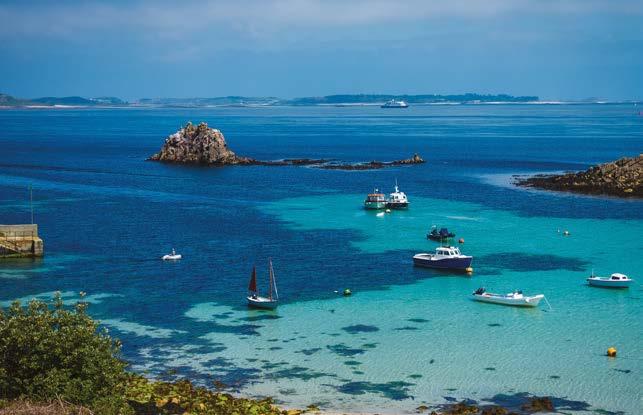
ABOVE RIGHT
The limpid waters of Tresco are like something from the Mediterranean
BELOW
Mousehole in Cornwall, not far from Penzance
USEFUL CONTACTS
St Mary’s Harbourmaster
VHF Ch.14 or +44 1720 422 768 Out of hours: +44 7789 273 626
Sibley’s fuel (St Mary’s)
+44 7810 301 060
Tresco moorings
+44 1720 423 653 or +44 7778 601237
Tresco Island Estate
+44 1720 422 849
Doctor (St Mary’s)
+44 1720 422 628
Police (St Mary’s)
+44 1720 422 444
Scilly Steamship Company
+44 1736 334 220
Taxis
DJ Cabs: +44 1720 423 775 Island Taxis: +44 1720 422 635