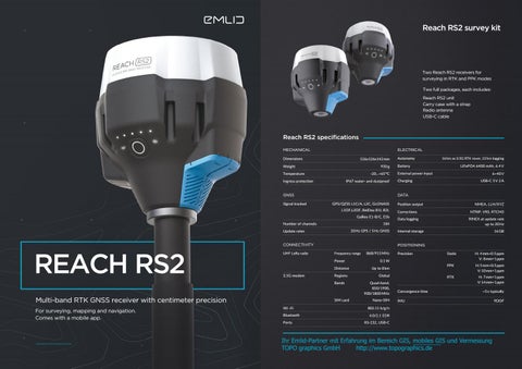
Reach RS2 survey kit
Two Reach RS2 receivers for surveying in RTK and PPK modes Two full packages, each includes: Reach RS2 unit Carry case with a strap Radio antenna USB-C cable
Reach RS2 specifications MECHANICAL
ELECTRICAL
Dimensions
126x126x142 mm
Weight
950 g
Temperature
-20...+65 °C
Ingress protection
IP67 water- and dustproof
GPS/QZSS L1C/A, L2C, GLONASS L1OF,L2OF, BeiDou B1I, B2I, Galileo E1-B/C, E5b
Number of channels
20 Hz GPS / 5 Hz GNSS
CONNECTIVITY
REACH RS2
Frequency range
Distance Regions Bands
Multi-band RTK GNSS receiver with centimeter precision For surveying, mapping and navigation. Comes with a mobile app.
SIM card Wi -Fi Bluetooth Ports
LiFePO4 6400 mAh, 6.4 V
External power input
6–40 V
Charging
USB-C 5 V 2 A
Position output
NMEA, LLH/XYZ
Corrections
NTRIP, VRS, RTCM3
Data logging
RINEX at update rate up to 20 Hz
Internal storage
16 GB
POSITIONING
Power
3.5G modem
Battery
184
Update rates
UHF LoRa radio
16 hrs as 3.5G RTK rover, 22 hrs logging
DATA
GNSS Signal tracked
Autonomy
868/915 MHz
Precision
Static
H: 4 mm+0.5 ppm V: 8 mm+1 ppm
PPK
H: 5 mm+0.5 ppm V: 10 mm+1 ppm
RTK
H: 7 mm+1 ppm V: 14 mm+1 ppm
0.1 W Up to 8 km Global Quad-band, 850/1900, 900/1800 MHz Nano-SIM
Convergence time
~5 s typically
IMU
802.11 b/g/n 4.0/2.1 EDR RS-232, USB-C
Ihr Emlid-Partner mit Erfahrung im Bereich GIS, mobiles GIS und Vermessung TOPO graphics GmbH http://www.topographics.de
9DOF
Key features
Surveying with ReachView
Gets fix in seconds
22 hours on 1 charge
Reach RS2 gets fixed solution in just seconds and maintains robust performance even in challenging conditions. Centimeter accuracy can be achieved on distances over 60 km in RTK, and 100 km in PPK mode.
Up to 22 hours of autonomous work when logging data and up to 16 hours as a 3G rover, even in cold weather. Reach RS2 can charge from a USB wall charger or a power bank over USB-C.
Built-in 3.5G modem
PPP support
Reach RS2 features a power-efficient 3.5G HSPA modem with 2G fallback and global coverage. Now corrections can be accessed or broadcasted over NTRIP independently, without relying on Internet connection on your phone.
RINEX raw data logs are compatible with OPUS, CSRSPPP, AUSPOS, and other PPP services so now you can get centimeter-precise results in any place on Earth. Process RINEX files in an online service and get position with absolute accuracy.
Intuitive software for data collection is available for Android and iOS. With ReachView, you can collect and stakeout points and control your Reach RS2 unit. Set up a base station, log RINEX data, configure NMEA output—everything in one app.
Point collection Create projects and save points with custom name and description. Set rules for data quality. Data collection is fast and intuitive, because ReachView is designed to feel like most popular map apps. Export DXF, CSV, GeoJSON, ESRI Shapefile
Stakeout Engineered to be tough Reach RS2 is designed to work even in the most challenging environments.
-20 °С...+65 °С Tested in conditions that simulate coldest winters and hottest summers.
IP67 RS2 is waterproof up to 1 m depth. Connectors are safely protected from water and dust with silicone plugs.
ReachView guides you like a navigator. On 50 cm distance from a point app’s interface turns into bullseye view. Move the receiver to align bubbles on the screen, and when it turns green—you are on the point. Import CSV, DXF, GeoJSON
Logging Record raw data, position and base correction logs. 16 GB of internal storage, 160 days of logging at 1 Hz. Log formats RINEX2.X, RINEX3.X
Polycarbonate body
Base and rover for RTK and PPK Rugged 5/8" mount
Covered with elastomer
SIM
LoRa radio
RS-232
5/8" mount
USB-C
Ihr Emlid-Partner mit Erfahrung im Bereich GIS, mobiles GIS und Vermessung TOPO graphics GmbH http://www.topographics.de
Real-time navigation
Base station mode
Reach RS2 can send precise coordinates over Bluetooth or Wi-Fi to your tablet with a lightbar navigation app. RS-232 interface allows to connect Reach RS2 directly to an autosteer system.
Use RS2 to set up your own base station. Stream corrections over the network via NTRIP/TCP or LoRa radio, record base logs for post-processing. RS2 works with any amount of rovers and is compatible with Reach RS+ and M+.
Compatible apps: MachineryGuide, AgriBus-Navi, Efarmer, Agripilot. Solution formats: NMEA, ERB, plain text.
Compatible with any reciever that supports RTCM3 and NTRIP. External radios are supported over RS-232.
For survey and navigation with centimeter accuracy
ReachView app Sleek and intuitive software that turns any smartphone into an advanced field controller for Reach RS+.
What’s inside
Reach RS+ can deliver centimeter-accurate coordinates over multiple wireless or wired channels making it a universal tool for all kinds of precision-demanding applications.
Multi-system support
Base station
Point stakeout
Helps with setup
Surveying tools
Rugged casing
Use Reach RS+ to set up your own base station. Stream corrections over the network via NTRIP/TCP or LoRa radio. Record base logs for post-processing.
Point Stakeout feature available in the app allows you to import a list of points of interest. Follow the app’s guidance to reach the exact spot.
Easily configure correction input, solution output, update rate and satellite systems in use. Manage Wi-Fi and Bluetooth connections.
Built-in tools for data collection. Record geolocations with specified accuracy. Import and export in industry standard formats.
Tough polycarbonate shell is specially crafted to protect Reach RS+ from falling and everyday wear.
Correction format: RTCM3. Log format: RINEX.
Importing formats: DXF, GeoJSON and ESRI Shapefile.
GPS, GLONASS, BeiDou, Galileo, QZSS, SBAS
Dual-feed antenna
Field-ready
With tight phase center variation
Long range radio LoRa 868/915 MHz for reliable connection on distances up to 8 km
30 hours battery LiFePO4 battery, USB charging, external 5–40V input
8 GB of storage Built-in memory for logs
IP67 certified
Point collection
Machinery guidance
Status monitoring
Log management
With Reach RS+ you can create survey projects to manage data collection. When working in the field each point is assigned a custom name and offset. Results can be downloaded from the project list.
Reach RS+ is able to provide precise coordinates over Bluetooth/Wi-Fi to your tablet with a lightbar navigation app. RS232 interface allows to connect Reach RS+ directly to an autosteer system.
ReachView shows current satellite signal strength, constellation visibility forecast, your location on a map and much more.
Logs are automatically recorded in internal memory. View a list of the logs and download them using the ReachView app.
Exporting formats: CSV, DXF, GeoJSON and ESRI Shapefile
Solution formats: NMEA, ERB, plain text. Compatible apps: MachineryGuide, AgriBus-Navi, Efarmer.
Sealed enclosure makes Reach RS+ water- and dustproof allowing it to work in any weather.
-20...+65°C Industrial grade components ensure smooth operation no matter what the season is.
ReachView is available on:
Ihr Emlid-Partner mit Erfahrung im Bereich GIS, mobiles GIS und Vermessung TOPO graphics GmbH http://www.topographics.de