4 minute read
2.3 Live Case Studies

Sabarmati Riverfront Development

Advertisement
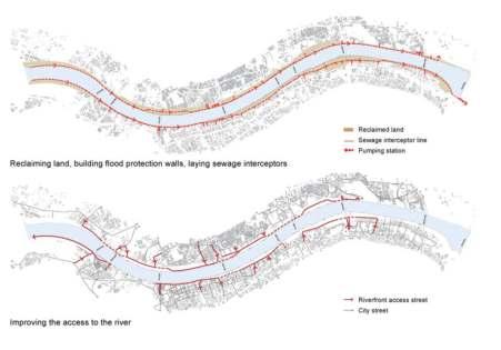
The Sabarmati River Front Development Corporation Limited (SRFDCL) was established in 1997 for the development of the riverfront in the city. (1) SRFDCL reached out to a number of NGOs and citizen groups for planning and implementation. The process of implementation was done by build, maintain, operate and transfer. SRFDCL appointed Independent Third Parties to supervise the private sector contractors who were selected on fixed time and rate. The fund for the project is set out by dierent sources that are equity capital, loan fund and proceeds from land sales.
Riverfront Land Use
The proposed development is of mixed land use that includes commercial, recreational and residential developments within the both sides of the river bank from Gandhi Bridge to Sardar Bridge.
The river originates from the foothills of Aravali ranges near Udaipur, Rajasthan and flows downstream passing through Ahmedabad till Gulf of Cambay. The 109 km river runs across a stretch of about 55 km through Ahmedabad. It is that stretch that is developed as an ambitious urban renewal project.
Development in Dierent Sector
The major component of the project includes reclamation works, construction of roads and installation of infrastructure such as water, sewer network, storm water drainage, etc., resettlement and rehabilitation work, construction of promenades and gardens and maintenance of public spaces.
Rehabilitation of Slum Dwellers
There were around 12000 hutments on both sides of the river bank that cover nearly 20% of the critical project area. More than 10000 families are allotted with houses for resettlement, and 9078 odd families have already been shifted. Each house is of 26.77 sq m carpet area. Commonly the relocation of a slum is provided on the outskirts of the city, but in this case, it is located near to the prime location of the city.
Gujari Bazar - Sunday Market
It is an age-old Sunday market, where 40% of traders were women and half of them describe themselves as Dalits. It was unhygienic and also there is a risk of flooding in monsoon. Now, it is spread over 70.00 sq.mt area, and 1600 vendors can do their business on 788 pucca platforms and 783 laris.
Around 172 Dhobis were using both the bank of the river for washing activities. On the eastern bank of the river near Vasna Barrage is constructed as dhobi ghat spread over approx. 9400 sq.mt area has utility area of about 600 sq.mt. There are seven blocks in modern Dhobi Ghat, and each block has 24 units with well-developed water supply and drainage system with a water meter for inlet watering.
Event Area
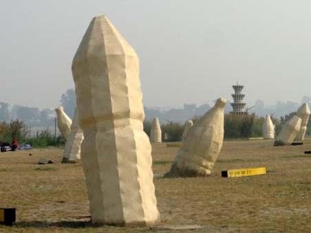
Earlier the dry river bed was used to host events like circus and cricket etc. However, a mega city like Ahmedabad requires proper event management ground facilities. So that an area of 60.00 aq.mt, spread between Sardar Bridge and Ellis Bridge on the west bank has been designed for hosting events such as the Kite Festival, the Marathon, the Cyclothon and Garib Kalyan Mela are organized.
Urban Forestry
Between Vasna Barrage and Ambedkar Bridge, the unique aorestation project is situated over 1 lakh sq.mt area. Natural forestry is being developed with dierent plant species from Gujarat, including certain very rare species.
Sewage System
To intercept the sewer running into the river and divert it to the treatment plants, the interceptor sewer system was constructed. Earlier the sewage from 36 drainage points directly falls into the river that makes the water dirty, mosquito ridden and an unhealthy environment. Now, there is an extreme change in the environment around the river because all sewage goes to a pumping station to transform it to river quality.
Promenade
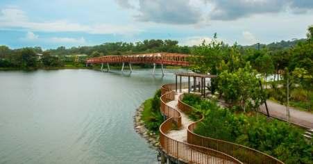
A key feature of this project is a two-level, continuous walk on both sides of the river bank built just above the water level for pedestrians and cyclists. So there will be no private ownership of the river bank, and the whole stretch is open for every citizen.
Public Garden/ Flower Garden
For parks and garden space 27% of project land is developed. There are three gardens.
● Garden of 60000 sq.mt between Subhash Bridge and Dadhichi Bridge;
● Garden of 25000 sq.mt at Usmanpura between Gandhi Bridge and Nehru Bridge on the West Bank and Flower garden of 40000 sq.mt near the event area on the west bank of the river.
Concluding Remark
The abused river can be brought back to the city by utilizing the resources of the river itself and convert the abandoned land of riverbed and nuisances at the centre of the city into people's attraction, tourist attraction, creation of infrastructural and recreational facilities and transform the city more livable in terms of environmental improvement and inclusive development.
YAMUNA RIVERFRONT DEVELOPMENT PROJECT (YRDP)
● DDA’s initiative of Biodiversity Parks in collaboration with the Center for Environmental Management of Degraded Ecosystems (CEMDE), Delhi University.
● Justice Usha Mehra Committee constituted to remove Jhuggies & other encroachments from the River Bed.
● Following the orders, DDA proposed Golden Jubilee Parks Approval from Central Water Commission for Golden Jubilee Park.
● Constitution of Delhi Biodiversity Foundation by Gazette Notification dated 01.04.2005.
● High Court Order for 13 enclosures to be made for disposing of Puja Samgiri in the river.
● Embargo on any construction activity by the oce of Hon’ble LG on Zone ‘O’ till detailed studies are done.
● Yamuna Riverfront Development Project Launched.
● The Structure Plan for Zone O was put up for inviting objections & suggestions.
● Structure Plan sought approvals from Delhi Biodiversity Foundation & High Powered Committee.
● ZDP for Zone O notified with proposals for Riverfront Development.
Zonal Development Plan, Zone - O
Recommendations of MPD,2021 & ZDP, Zone O
● River Yamuna should be conserved & kept free from unrestricted & unplanned urban development.
● ZDP has proposed strategies for Sustainable Riverfront Development.
● Strategy for Conservation / Development of Yamuna riverbed area is needed to be developed & implemented in a systematic manner.
Aim
“Conserve, Protect & Restore the Biodiversity of Yamuna integrated with Public Recreation spaces that the city needs as envisaged in the Zonal Development of Zone O”.
The Structure Plan
The floodplain has been studied & analyzed based on several ecological & physical parameters, such as:
● existing natural features like water bodies, vegetation, etc.,
● proximity to habitation & movement corridors,
● intensity & conformity of abutting activities, &
● socio-cultural characteristics
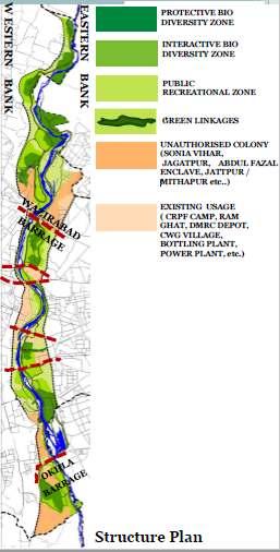
Green Linkages- Interconnecting all zones are Green Linkages which will act as wildlife movement corridor & provide habitat while providing a buer to sensitive Biodiversity areas.
All these Zones are Open to Sly Green Areas.