
11 minute read
Interstate and Federal Law


Interstate Compacts, Equitable Apportionment Decrees and Treaties
Colorado is a headwaters state, where four major rivers begin—the Colorado, Arkansas, Platte, and Rio Grande— supplying water to 18 downstream states and Mexico. However, Colorado must live within its water constraints. The first and most basic constraint on water use within the state is the amount of rainfall and snowfall that occurs each year.
Advertisement
The second constraint is legal: Colorado has obligations to limit its uses and deliver water to downstream states under interstate water compacts and U.S. Supreme Court equitable apportionment decrees. Meeting these obligations can be viewed as Colorado’s top water right administrative priority. Failure to meet the terms of the Arkansas River Compact, for example, resulted in expensive litigation and a 2005 ruling that Colorado pay $34 million to Kansas. International treaties with Mexico also affect Colorado’s water use.
The unbridled ability of states to allocate and govern water use within their borders halted early in the 20th century. In 1907, the Supreme Court in Kansas v. Colorado held that all states sharing a stream system were entitled to an equitable share of river water. Under equitable apportionment, the U.S. Supreme Court has authority to allocate a state’s share of river water from time to time based on another state’s need, if a state files directly with the high court.
The compact clause of the U.S. Constitution allows states to fix their allocations in perpetuity by contract, with congressional approval. An interstate compact is both state and federal law. This promotes long-term planning and reliability and diminishes the rush to develop water as soon as possible. Due in great measure to the efforts of Delph Carpenter, son of a Weld County homesteader, Colorado entered into nine interstate water compacts as alternatives to court apportionment. Colorado water use is also affected by three U.S. Supreme Court equitable apportionment decrees.
Because of interstate and international requirements, Colorado passes a large amount of water out of state. In an average year, about 16 million acre-feet of water flows in streams and aquifers as a result of precipitation that falls over Colorado but Colorado can consume only approximately one-third of that water because of interstate and international legal obligations. While there may be water in the Colorado River system that Colorado has not yet developed under its 1922 Colorado River Compact and 1948 Upper Colorado River Basin Compact entitlements, its use of Arkansas, Republican, Rio Grande and South Platte water is subject to strictly enforced requirements constraining water uses within Colorado.
Drought and warm temperatures can greatly alter the amount of water available for in-state and out-of-state use. For example, a 2017 paper in the journal Water Resources Research found that native flows in the Colorado River Basin have fallen by about 18 percent since 2000, with about one-third of that reduction due to higher temperatures brought on by climate change.
For a detailed summary of the compacts, equitable apportionment decrees and treaties, see WEco’s Citizen’s Guide to Colorado’s Interstate Compacts.
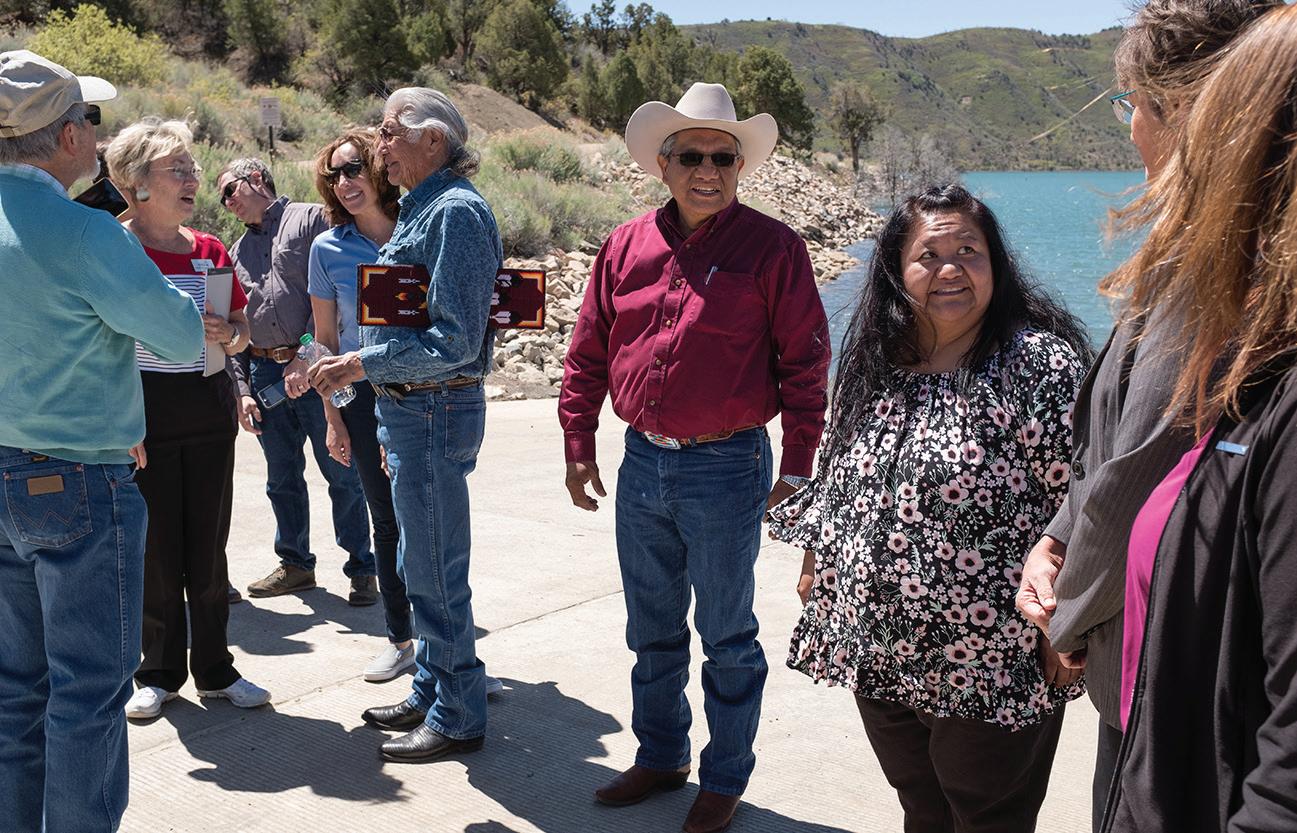
Southern Ute and Ute Mountain Ute tribal council members stand alongside U.S. Bureau of Reclamation, state, and city officials for a 2018 ribbon cutting at Lake Nighthorse. As part of the Animas-La Plata Project (A-LP), the reservoir was authorized in 2000 through an amendment of the Colorado Ute Indian Water Rights Settlement Act. The act entitled tribes to water from the proposed A-LP, as well as from the Dolores Project’s McPhee Reservoir. A-LP construction began in 2001, Lake Nighthorse began filling in 2009, and the reservoir opened to recreation in 2018.
Jeremy Wade Shockley / Southern Ute Drum
Colorado River Compact of 1922
The Colorado River Compact of 1922 divides the water of the Colorado River. The framers of the compact divided up to 15 million acre-feet of consumptive use water between the upper and lower basins as measured at Lee Ferry, just downstream of Lake Powell. They allocated 7.5 million acre-feet per year to the lower basin— Arizona, California, Nevada, and parts of Utah and New Mexico—and 7.5 million acre-feet to the upper basin—Colorado, New Mexico, Utah, Wyoming, and some of Arizona. Another 1 million acre-feet of annual consumptive use was allocated to the lower basin for flows from the Gila River, a tributary that enters the Colorado River near Yuma, Arizona. Although the upper basin’s share was intended to equal that of the lower basin, the upper basin states cannot, through the depletion of post-compact water rights, cause the river’s flow to fall below 75 million acre-feet at the Lee Ferry gauge over any consecutive 10-year period, or an average of 7.5 million acre-feet per year. In addition, another 1.5 million acre-feet must flow to Mexico each year, under the Mexican Water Treaty of 1944.
Prolonged drought and aridification due to climate change have led to declining Colorado River water supplies. There is considerable uncertainty about how much water, if any, remains for additional consumptive uses under the 1922 and 1948 compact allocations. Depending upon the period of record used to estimate average annual natural flows in the upper basin, there may be some increment of water available for new uses or no additional water at all. The flows recorded during several dry periods, including the most recent decades, indicate that the upper basin is already using more than the annual average available. The U.S. Bureau of Reclamation is conducting ongoing studies and issuing reports regarding Colorado River water availability under various risk scenarios.
The seven basin states have implemented and are continuing to discuss cooperative measures for reduction of deliveries and modified operation of storage reservoirs in times of shortage, with the aim of creating a sustainable water balance in the basin and avoiding compact litigation. The 2007 Colorado River Interim Guidelines for Lower Basin Shortages and Coordinated Operations for Lake Powell and Lake Mead were meant to address the Colorado River’s deteriorating storage levels. In 2019 the Colorado River Drought Contingency Plan was authorized, activating a Binational Water Scarcity Plan, with separate plans for the upper and lower basins and Mexico to hedge risk and reduce some reliance on the Colorado River.
Arkansas River Compact of 1948
This compact apportions the waters of the Arkansas River between Colorado (60 percent) and Kansas (40 percent) based on the inflow to John Martin Reservoir during the winter storage season (December 1 to March 31). This water in storage can be released at the demand of either state after April 1.
Colorado and Kansas have often been in litigation before the U.S. Supreme Court over Arkansas River water. In 1995, the U.S. Supreme Court found that Colorado had depleted the flow of the Arkansas River at the state line in violation of the compact. Irrigation wells installed after execution of the compact caused these depletions. The states have litigated the nature and extent of the injury to Kansas, and Colorado has paid over $34 million in damages to Kansas, as directed by the U.S. Supreme Court. In response to an order of the Special Master, the Colorado state engineer has developed well administration rules to bring Colorado into compliance with the compact (see 37-69-101 to 37-69-106 C.R.S.). In 2003, the Colorado General Assembly affirmed the state engineer’s authority to adopt and enforce the Arkansas Basin rules.
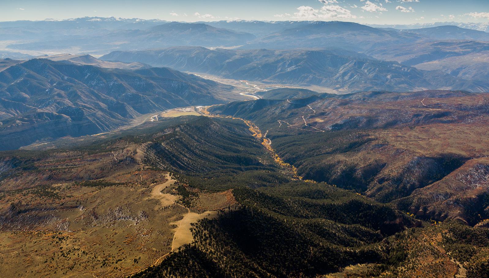
The Wild and Scenic Rivers Act preserves “selected rivers with outstanding natural, cultural and recreational values in a free-flowing condition for the enjoyment of present and future generations.” Colorado boasts only 76 miles of one wild and scenic river, the Cache la Poudre. Concerns about future water storage and shortage have led stakeholders to alternatives on other rivers, but a 12-mile stretch of Deep Creek, pictured here, which flows into the Colorado River just above Dotsero, was still a candidate for wild and scenic designation as of late 2020.
EcoFlight
Federal Reserved Water Rights
In 1908, the Supreme Court in Winters v. United States determined that the states could not deprive Native Americans of the water reserved for them by implication on the date when Congress created that tribal reservation. This decision generated the doctrine of federal reserved water rights, created expressly or by implication.
Implied federal reserved rights refer to water that was unappropriated on the date the reservation was created, in the minimum amount necessary to achieve the primary purposes of the reservation. The priority date of this type of reserved water right is the date the reservation was created. Subsequently, the U.S. Supreme Court and various state supreme courts have upheld implied federal reserved rights for numerous national parks, monuments and other federal reservations created through acts of Congress. Federal reserved water rights may also be created expressly, for example, by the national Wild and Scenic Rivers Act.
As a result of this legal precedent and to allay Western concerns about exclusive federal control over tribal and federal water claims, Congress adopted the 1952 McCarran Amendment. This amendment permitted state courts to adjudicate federal and tribal water claims. These included express and implied federal reserved water rights and federal claims to state law-based water rights. Since then, Colorado has adjudicated federal and tribal reserved rights claims and the state administers them in priority, along with state-based water rights.
For example, Rocky Mountain National Park and the Wild and Scenic designated reaches of the Cache la Poudre River have Colorado water court decrees for federal reserved water rights. A negotiated decree entered in Colorado water court for the Rio Grande Basin recognizes U.S. Forest Service rights. The Southern Ute and Ute Mountain Ute tribes settled their federal reserved water rights claims in return for the Animas-La Plata Project, which the U.S. Bureau of Reclamation constructed. A proceeding to determine the amount of the reserved water right for the Black Canyon of the Gunnison National Park resulted in a settlement agreement and a water court decree protecting water flows in the park and upstream in-basin uses.
Environmental Protection
The 19th century’s pro-development policies of the state and federal governments had consequences. Back then, the beauty and natural resources of Colorado must have seemed inexhaustible and the need to use them pressing.
By the close of the 19th century, national and state agendas began to shift from unmitigated use of natural resources to progressive conservation. As a result, President Teddy Roosevelt and his forester, Gifford Pinchot, pushed to protect the forested lands from impacts caused by uncontrolled timber harvesting, homesteading and other uses. More than 14 million acres of national forest land exist in Colorado today, of which nearly 4 million acres are designated wilderness.
Creation of national forests initially caused alarm in Colorado because many reservoirs and ditches existed within the forest due to the earlier laws that allowed entrance on public lands for water diversion, storage and delivery systems. President Roosevelt convinced farmers and cities that forest protection was important to water production.
To alleviate concern that creation of the forest reserves would obstruct the ongoing use and development of water resources on the national forests, the 1897 Forest Organic Act contained a provision preserving federal law and forest rules while ensuring state water law would continue to apply to water rights on the national forests.
By the mid-1960s, 100 years of U.S. policy favoring water development began to shift to include environmental protection and preservation. Laws such as the 1964 Wilderness Act, 1970 National Environmental Policy Act, 1972 Clean Water Act, 1973 Endangered Species Act, 1976 National Forest Planning Act, and 1976 Federal Land Policy and Management Act impose regulatory constraints on the construction of new or enlarged water projects. These laws have greatly expanded citizen participation in water decision-making processes. No significant federal action affecting the environment can go forward without the opportunity for citizens to comment. In turn, this has pushed Colorado decision makers to examine alternatives to proposed water projects.
Compliance with the Endangered
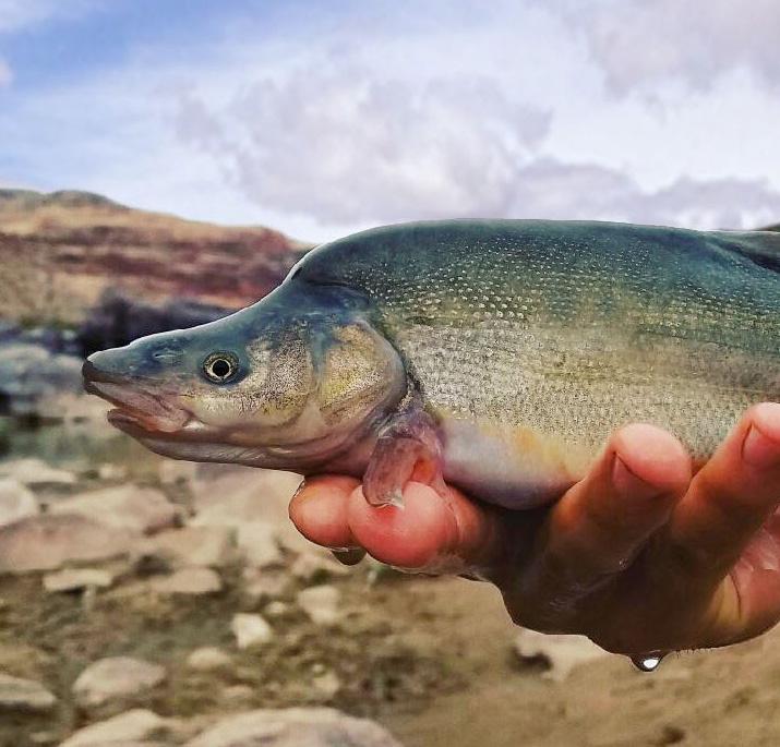
Partners of the Upper Colorado River Endangered Fish Recovery Program are working to recover four endangered fish species in the Colorado River and its tributaries: the humpback chub (top), Colorado pikeminnow, bonytail (bottom), and razorback sucker.
U.S. Fish and Wildlife Service

Species Act is important to Colorado’s ability to use the waters provided in its interstate compacts. The Upper Colorado River Endangered Fish Recovery Program is a joint effort with the U.S. Fish and Wildlife Service and other federal, state, water user, and environmental organizations to recover four endangered Colorado River native fish: the Colorado pikeminnow, humpback chub, bonytail, and razorback sucker.
Participation allows upper basin state water users to qualify for federal permits and other approvals needed to construct water facilities and apply for new water uses. The Platte River Recovery Implementation Program, including Colorado, Wyoming and Nebraska, protects the interior least tern, whooping crane, pallid sturgeon, and piping plover.
Federal laws and regulations add complexity to Colorado’s ability to meet its water needs. For example, Section 404 of the Clean Water Act requires a U.S. Army Corps of Engineers permit to place dredged or fill material into waters of the United States, which includes rivers and wetlands. This means that virtually all dams and many water diversion structures require federal approval, and public environmental review under the National Environmental Policy Act. The U.S. Environmental Protection Agency (EPA) possesses veto authority over these permits under Section 404(c) of the Clean Water Act, although EPA has exercised a final veto only 13 times in the last 45 years. In 1990, EPA vetoed the Denver Water Board’s application for the Two Forks Dam, which had attracted substantial opposition (see WEco’s Citizen’s Guide to Colorado’s Environmental Era).
Particularly controversial have been cases where the U.S. Forest Service (USFS) required bypass flows as a condition for issuing or renewing special use permits or right of ways for water diversion facilities, structures, reservoirs, or recreational developments (such as a ski area) on USFS lands. A bypass flow is an amount of water required to flow past a dam or diversion to support downstream forest water needs, such as wildlife habitat or recreation. The USFS has, at different times, taken the position that its statutory authority to regulate the use and occupancy of USFS lands includes the authority to impose bypass flows or other water-related conditions in special use permits or right of ways.
Opponents of bypass flows argue they illegally and inappropriately intrude into Colorado’s legal authority to allocate and manage instream flows and water use; supporters insist they are a legally authorized and necessary tool for the USFS to protect water-dependent resources in national forests, given the existing decreed water rights held by private water users with on-forest dams and diversions. The Colorado General Assembly has successfully urged the USFS and other federal agencies to work with the Colorado Water Conservation Board on streamflow needs using the instream flow water rights program under Colorado state law rather than impose bypass flows.


