4 minute read
A Jaunt to Jiaming Lake (嘉明湖)


Have you climbed Jade Mountain? How many Bai Yues (mountains over 3,000m) have you done? In Taiwan, these are common questions related to hiking locations. Today I'd like to throw a lake into the mix: Jiaming Lake to be precise. At 3310m it's the second-highest lake in Taiwan
(Cuichi Lake is the highest) and it's in the Xiangyang National Forest. This is a wonderful one or two-night excursion depending on where you start from. However, you must apply for a permit for this hike so don't just turn up at the trailhead ready to go, advance preparation is required.
Advertisement
I visited this area last month with a group of friends and we had a fun three-day trip. We arrived at the trailhead around 2 pm and hiked for about three hours through woodland before reaching Xiangyang Cabin. This section of the hike was a relatively gradual uphill walk through trees dripping with moss and lichen and the odd glimpse of mountains through the forest and clouds. The cabin was quite simple: rows of bunks with individual mats and sleeping bags provided. The squat toilets were in a separate building and were basic but clean. The food was good with a selection of dishes and lashings of ginger tea. Due to the long day, cold temperature (around 5 degrees) and no electricity we were all in bed by 8 pm and determined to stay there until the morning to avoid the outdoor bathroom … and bears!
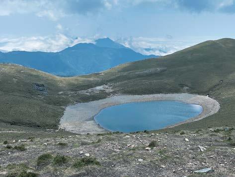
On the second day, we set off at around 5 am to hike up to the Jiaming Lake Cabin at 3,350m. The sun was not exactly rising, but light appeared quickly so we didn’t need our head torches. This was the steepest section of the hike and was challenging due to the heavy backpack and the altitude. After passing the Xiangyang Tree - a hardy pine that must be hundreds of years old and stands out as it's much taller than the scrub around it, even at just two meters - the mist rolled in and the view totally disappeared. So, it was something of a relief to arrive at the second cabin around 9 am. We had a brief rest and then set off to find the lake with just a day bag, which was much easier. This section of the hike is more like rolling hills. After a couple of hours hiking with white walls of fog on either side, rays of sunshine started poking through. Every now and again the clouds blew open and we glimpsed mountains all around us, so we knew we really were up high. We finally reached the lake around 12 and the fog obliged by clearing enough to give us a full view of the lake and mountains nearby.
The lake itself had a wide brown rim as the water level was quite low. So the nickname Angel’s Tear Drop didn’t quite fit but it was still beautiful. We walked down to the edge of the lake but did no more than dip our fingers in as it was rather cold. We then enjoyed lunch with a lake view and recharged our batteries for the return journey. As soon as we set off the fog rolled in again and the views disappeared. We still ventured up to the top of Mount Sancha at 3,496m so we could say we had done one of
Taiwan’s Bai Yue. However, we didn’t linger as there was no view and then we headed back to the cabin as it was already a pretty chilly 8 degrees. This cabin is also very simple with rows of bunks and toilets in a separate building. However, a mix of high altitude and cold air meant snuggling in the sleeping bag was the obvious option and everyone was happy with an early lights-out time. On day 3 we set off at sunrise and this time the sun did rise and the hike down to the trailhead was totally different from our ascent. We could see the mountain ranges all around us and we were impressed with the ground we
Bai Yue 28: Mount Sancha had covered! We had spectacular views down to the sea of clouds hovering over the valley. I spotted various wild flowers daring to bloom, including the first rhododendrons of the season, and we came across a family of monkeys also taking in the sunshine. We arrived back at the trailhead full of the joys of spring and happy to have had a few days of fresh air.


You could do this hike, a total of 26 km, with one night on the mountain but we opted for two to take it more slowly and get used to the altitude. Just bear in mind that you can’t guarantee good weather so be prepared for all

( four seasons! We left Taipei at 7 am on Sunday morning and drove down to Chishang on the east coast, enjoying views of the bright green rice paddies, before heading inland and up through Wulu Gorge to the trailhead which is close to the 155 km marker on Southern Cross-Island Highway. We were back in Taipei around 7 pm on Tuesday evening. If you’re looking for a short hiking getaway then this is a good option and I can highly recommend our guide Dory Chung, or, as I call her, Dory the Explorer. facebook.com/ExplorewithDory/ ) In the meantime, I shall start investigating how to get to Cuichi Lake … if I’ve made it to the second highest lake then clearly the only way is up!

Lucy Torres is the Programs Manager at The Center and enjoys organising different activities and events that cover topics from Taiwanese culture to environmental awareness.


