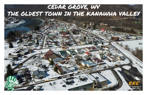
CEDAR GROVE, WV THE OLDEST TOWN IN THE KANAWHA VALLEY
Charleston
Kanawha City
a wh
na Ka
er
Regional Connections Situated along Route 60, Cedar Grove occupies a strategic position within the Upper Kanawha Valley recreation network and along a key east–west corridor connecting river communities to larger regional destinations. The town is approximately 25 miles upriver from Charleston, offering direct access to the state’s primary urban center, while also serving as a convenient pass‑through for travelers heading toward Beckley and New River Gorge National Park and Preserve. Its location along the Kanawha River further strengthens Cedar Grove’s role as an access point for water‑based recreation and river‑oriented tourism. The town also lies near the Appalachian Outlaw Trails system and is among the closest communities to the expanding Mammoth Preserve above Smithers, an emerging regional anchor for hiking, biking, and backcountry activities. With continued investment in trail connections, riverfront enhancements, and links to nearby recreation assets, Cedar Grove is well positioned to function as a natural waypoint within the broader outdoor recreation landscape. Its central location along Route 60 and proximity to Charleston, the New River Gorge region, Beckley, and the Kanawha River corridor position the town to support regional travel, recreation‑based economic activity, and increased visibility within southern West Virginia’s growing outdoor tourism network.
Malden
Rand
Riv
Dupont City Belle
Appalachian Outlaw Trails
Appalachian Outlaw Trails Phase 01 (Under Construction)
Future Phases
Dickinson
Marmet
Shrewsberry Chesapeake
Cedar Grove Glasgow
Pratt
Chelyan
London
East Bank Proposed Rim Trail
Montgomery Cabin Creek Water Trail
Hansford
Ka n
aw
ha
Mammoth Preserve
WV Land Trust Project (Under Design) Smithers
Riv
er
Proposed Rim Trail Proposed Rim Trail
Paint Creek Water Trail + Rail Trail
Boomer
ha aw
n Ka r
ve
Ri
Town of Cedar Grove Cedar Grove, situated along the Kanawha River in the Upper Kanawha Valley, stands as one of the region’s oldest and most historically rooted communities. Established in the 18th century around Fort Kelly and formally incorporated in 1902, the town grew from early river‑based industry, boat building, and salt production, with enduring landmarks such as the William Tompkins House and Virginia’s Chapel reflecting its rich past. These historic elements remain central to the town’s identity, showcasing Cedar Grove’s longstanding role as a pioneer settlement and cultural waypoint in the valley. Its location connects residents and visitors to a wider network of outdoor recreation opportunities throughout the Kanawha region. More than 15 nearby trails—such as the Elk River Trail, Kanawha Boulevard Trail, and Clear Fork Rail Trail—offer hiking, biking, and nature‑based activities, making Cedar Grove a meaningful link within a broader
Historical Church
recreational landscape. These trail systems, supported by the region’s natural character and accessibility, help reinforce the town’s potential as both a local and regional outdoor gateway. Access to Cedar Grove is primarily provided by U.S. Route 60, the central transportation corridor through the Upper Kanawha Valley that connects the town to Charleston and surrounding communities. Within the town itself, small‑scale amenities shape everyday life: the Community Center hosts weekly events such as bingo that provide social interaction and multi-generational engagement, while a monthly auction at the beginning of each month continues to serve as a valued community tradition. Together, these elements highlight Cedar Grove as a historic, connected, and community‑oriented town poised for thoughtful planning and future investment.
Cedar Grove Fire Station
Cedar Grove Linear Park
Cedar Grove Municipal Building
The Valley Masterplan (2019) Kelly’s Creek Trail
Starting in Cedar Grove, cycle enthusiasts can enjoy a 24 mile share the road path to Pond Gap that offers a steady uphill climb and waves through the mountains. Kelly’s Creek Trail will connect users to the proposed Blue Creek Rail Trail and to the north entrance of the Mammoth Recreation Area, where more trails and adventures await.
Glasgow Boat Ramp Improvements
Viewsheds Along Kanawha River
Views of Site Area from River
N RIM
This existing boat ramp offers a great opportunity to revitalize the river access for Glasgow. Enhancements to circulation, parking, and pedestrian and ADA access will improve usage for the residents and attract new visitors to Glasgow. Located in the upper portion of the Marmet pool, the Glasgow Boat Ramp offers a great pull-in and take-out location for the water trail users.
Cedar Grove
North Rim Trailhead
Located in Cedar Grove, the North Rim Trailhead offers a starting point for various trail users. Positioned at the start of Kelly’s Creek Trail and along the North Rim Trail, the trailhead will be a hub for recreational activity. This location brings that traffic through the town and provides opportunities for economic stimulus to Cedar Grove and Glasgow. The North Rim Trail is a part of the overall community connection and tourism attractor, for “The Valley” making this trailhead an important contributor to the larger trail network.
Historical Thompkins House
View of Cedar Grove from Site
View The Valley Masterplan Here!
Glasgow
S RIM TRAIL
TRAIL
1
Site Inventory
NORTH
1 Main Entrance
2 Baseball Field
3 Batting Cage
4 Football Field
5 Tennis Court
6 Cedar Grove Elementary
7 River Views
8 Steep Slopes
9 Site Entry Road
10 Kelly’s Creek
11 Pedestrian Bridge
12 View of Cedar Grove
13 Linear Park
14 Basketball Court
15
G
eo
rg
e
St
14
W
am
St
Al
Pr
es
to
nS t
E
illi
ex an
de
St
13
EW ard
WW ard
St
rS t
ha
aw
t rS de
Joh nS t
an ex
Al
n Ka
6
r ve
Ri
2
9
4
3 10
8 7
5
11
12
15 Municipal Building
Site Analysis
The Cedar Grove site is a historically significant recreational landscape, shaped by decades of community use and memories associated with the former River City Park. Today, it contains a mix of active and underutilized features that frame its redevelopment potential. The baseball field continues to serve as a strong recreational anchor, while the adjacent football field,though in good condition, experiences limited use and presents an opportunity for reprogramming. A single on‑site tennis court has been identified by the community as a candidate for removal, freeing space for new amenities and supporting a return to the site’s historic role as a flexible, multifunctional gathering place. Nestled within a narrow river valley, the site is defined by its surrounding landforms and dramatic natural setting. While the central portion of the site remains largely flat and well suited for events and recreation, steep wooded slopes rise around it, offering striking views across the river and valley. These slopes, though limiting traditional development, create ideal conditions for terraced seating or an outdoor amphitheater oriented toward the water and scenic landscape. Connectivity remains one of the site’s greatest strengths. A well maintained pedestrian bridge provides a direct link between Cedar Grove and the Town of Glasgow, supporting shared recreational use and regional access. Sidewalks connect the site to nearby amenities, including a basketball court, community building, and linear park, reinforcing walkability and community cohesion. Together, the site’s historic character, scenic views, and strong pedestrian connections present significant opportunities not only for expanded recreation and programming, but also for economic development through events, tourism, and river‑focused activity that could benefit both Cedar Grove and Glasgow.
NORTH
To Thompkins House
Primary Site Access
Cedar Grove Owned Lot
Existing Railroad *Active*
Cedar Grove Basketball Court E
Ge
St
W
illi
St
nS t
Pedestrian Circulation
am
to
Town of Cedar Grove Linear Park
es
Al
Pr
*Via Sidewalks*
ex an
de
rS t
E Wa
WW ard
Cedar Grove Elementary School Parking
rd S t
e
g or
St
Cedar Grove Municipal Building
John
r
n xa Ale
ve
Ri
St
ha
aw
n Ka
Vehicular Circulation
de
1 Entry Road
2 Existing Baseball Field
3 Existing Football Field
4 Existing Batting Cage
5 Existing Tennis Court
6 Existing Sugar Maple
7 Good River Views
8 Existing Pedestrian
9 Kelly Creek Access
t rS
Cedar Grove Elementary School
*School Includes 3 Playground Areas*
4 Batting Cage
2 Baseball Field
*Limits Perimeter Trails Around Field, Needs Relocated*
*Good Condition, Utilized Often, Keep*
1 3
Cedar Grove Football Field *Good Condition, Maximize Usage, Amenity Development Opportunities*
5 Tennis Court
*Potential Amenity Space, Needs Removed*
6 Silver Maple
*Old Maple, Good for Shade*
Steep Hillside *Steep Slopes Leading to River, Great Terrain for Amphitheater, Amazing Views of River*
*Needs Removed*
8 Pedestrian Bridge
*Good Condition, Creates Good Pedestrian Connection Between Cedar Grove and Glasgow
r
C ’s
Burn Piles
7
9
lly Ke
k ee
oo *P
*
ss
ce
c rA
Town of Glasgow Connection *Clear and Safe Connection to Town of Glasgow. Opportunity to Unite the Two Towns Amenity & Recreation Areas*
Brdige
Cedar Grove Riverside Park
B
k
ar
p all
il
a Tr
Turf Football Field Parking Area 67Spaces
il
Open Field Play Area
e
sid ek
a Tr
e
Cr Splash Pad
6000 Sq.Ft. Restrooms Concession Stand
rop Off
D Kayak
(4) Picnic Shelters
ADA Kayak Launch + Fishing Dock (2) Picnic Shelters
wha
a Kan
Beach Area Existing Pedestrian Bridge
r
Rive
(1) Creekside Gazebo
NORTH
0
40’
80’