
10 minute read
Lever: Plan and decide inclusively


Bottom-up land use planning for equitable rural development in Lao PDR
Cornelia Hett, Phaythoun Pilakone, Kevin Kamp, Micah Ingalls and Andreas Heinimann

In the uplands of Laos, high poverty and insecure land tenure prevail. At the same time, traditional agriculture is being rapidly transformed into large-scale operations for commodity production and resource extraction. In this context, how can equitable economic development be achieved that both benefits family farmers and protects the environment? The participatory land use planning approach developed and implemented by the Agro-Biodiversity Initiative lays the foundations.
Three-quarters of Laos is mountainous and dominated by subsistence farming [1]. Most of the poor (87 percent in 2012/13) are rural, and poverty is concentrated in upland areas [2], where people generally lack formal land tenure rights [3]. Traditional swidden agriculture has resulted in a mosaic of natural forests, cultivated fields and forest fallows [4]. However, the Lao uplands are rapidly transforming due to (a) the economic integration into the Mekong region, (b) the national agenda promoting intensified, market-oriented agriculture and (c) the sparing of land for biodiversity conservation. The rural population benefits only marginally from these changes [5].
To promote pro-poor rural development, increase local tenure security and plan conservation, the Agro-Biodiversity Initiative (TABI) has developed a participatory forest and land use planning and management approach (FALUPAM) [6]. This bottom-up approach targets the village level and involves local residents and local/ district-level government staff. FALUPAM is a multistage process that is implemented jointly over several years, enabling trust building, fair negotiation and adaptive change management.
During the various stages of FALUPAM, actors: • Establish local land use planning committees and collect data on agrobiodiversity resources and socio-economy; • Work in inter-village negotiations to identify landscape features and delineate village boundaries; • Assess and map the current land use situation by considering all land uses, including land for swiddening, livestock grazing and collection of non-timber forest products;
Villagers and government representatives in the Lao uplands working to implement FALUPAM (K. Kamp)
“ FALUPAM is good because it is participatory – if people are involved in the process, they follow the results – and because it involves detailed data collection and decreases conflict within and between villages.”
Deputy Director, Agriculture and Forestry Office of Luang Prabang Province [6]
Pre-FALUPAM
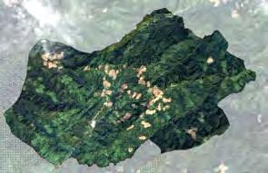
Forest areas
Rotational agriculture zones (other years)
Rotational agriculture zones (current years)
2016

2016, land use plan
Figure 1. Example of implementation of a negotiated land use zoning plan in Thathong village, Northern Laos. Top: Starting situation, with swidden agricultural fields dispersed across the village territory. Bottom: Spatial clustering of agriculture and forest areas during the land use planning process led to larger continuous spatial units, which enables more efficient annual cropping of upland fields and promotes “tidiness” of landscapes. Source: modified from [3]
• Co-design future land use management and zoning plans by jointly negotiating development priorities and assessing trade-offs of different land use options, including the practice of clustering cropped upland fields (see Figure 1); • Implement the plans, monitor the outcomes and, based on the outcomes, revise and update the plans.
The land use plans created under FALUPAM have been instrumental in creating clarity on land tenure. They respect local and customary tenure and are spatially precise in their clear definition of land use categories. The plans have also been recognized at higher administrative levels, making them the foundation for further development planning.
For the villages, the benefits of FALUPAM have been: • Economic: The clustering of cropping land has led to improved land management and thus economies of scale for agricultural production. It has also secured the production of high-value (but long-rotation) agrobiodiversity crops (e.g. benzoin trees, or tea from ancient tea forests) by delineating forests for agricultural use; • Social: Clustering the upland fields has strengthened village social networks through collaboration and coordination on land use. It has increased villagers’ negotiation capacity towards outsiders and reduced inner and inter-village land use conflicts. FALUPAM facilitated a constructive dialogue on the politically sensitive topic of swiddening, with government representatives from district and provincial levels; • Environmental: Forest fires were reduced through more effective cooperation on fire control. The clearly defined areas of forest conservation and restricted use, also across village boundaries, led to larger continuous natural habitats and wildlife corridors. FALUPAM directly increased conservation forest areas by 9.5 percent and has contributed to the national strategy of increasing forest cover nationwide.
FALUPAM has been implemented in over 300 villages in 13 provinces. Training was provided to more than 70 government staff, faculty members and students at the National University, and staff of other major rural development projects. • Land use planning is important to drive self-determined economic development at village level and simultaneously promote ecosystem services that are relevant for all levels, from local to global. • To be effective, land use planning should provide space for the engagement of villagers, representatives of neighbouring villages and representatives of different levels and sectors of government. To build trust and ownership, land use planning should be carried out in an iterative way and over a long period. • Adaptive change management is crucial to address challenges as they arise, and to take advantage of unforeseen opportunities. This means that land use zoning plans should continue to be evaluated and monitored – and, if needed, adapted.
The Agro-Biodiversity Initiative (TABI)
TABI is a joint programme of the Ministry of Agriculture and Forestry of the Government of Lao PDR and the Swiss Agency for Development and Cooperation. It aims to improve the livelihoods and incomes of local upland farmers by developing and facilitating opportunities to protect and enhance agrobiodiversity. An evaluation in 200 villages showed that 66 percent of the villages followed the FALUPAM land use plans closely. One-quarter had minor difficulties in respecting the forest boundaries, and only 9 percent largely failed to comply with the plans. Reasons for failure included (a) unforeseen major land use interventions (e.g. granting of concessions at higher administrative levels) and (b) cultural constraints preventing clustering of upland fields [3].
Scenarios to steer and support development of mountain regions in Albania
Anila Gjika and Fiona Imami
Creating development scenarios was key to addressing increasing disparities in northern Albania’s mountainous Shkodra county. The scenarios helped to identify Shkodra’s development potentials and initiate promising pilot projects towards sustainable and balanced socio-economic development. The approach was scaled up and incorporated into Albania’s upcoming Regional Development Policy (2021–27), which aims at taking advantage of the region’s endogenous resources to improve people’s well-being.
In the last 30 years, Albania has experienced high outmigration from peripheral mountain areas towards the country’s centre and its western coast. Economic activities became clustered in the recipient areas, and the development of other regions lagged behind. Since 2002, the Government of Albania (GoA) has undertaken efforts to promote a more balanced regional development. However, the reforms implemented were either top-down or entirely local, fragmented and lacking in essential national-level ownership that would enhance cohesion and ensure sustainability. In response, since 2010 the Regional Development Programme (RDP) has been supporting Albania’s Regional Development Reform through piloting a comprehensive process in Shkodra and Lezha counties in northern Albania and strengthening coordination, capacity and institutions countrywide (Box). The approach has flowed into the Regional Development Policy, which, once approved, will cover the years 2021 to 2027.
Shkodra county (or “qark”, in Albanian) is characterized by mountainous terrain and, despite its diverse potentials, faces challenges to promote a sustainable and competitive economy. First, travel between the region and urban hubs is lengthy and difficult. Second, its rural areas have among the highest unemployment rates (16.6 percent compared to the national average of 10.3 percent), high migration rates (–20.8 percent for 2001–2017) and low economic performance (GDP per capita has been 25–30 percent lower than the national average for the last 15 years). And third, while the region is quite rich in natural and cultural/heritage potentials (10 protected areas and 210 natural monuments), the tourism sector remains fragmented and underdeveloped.
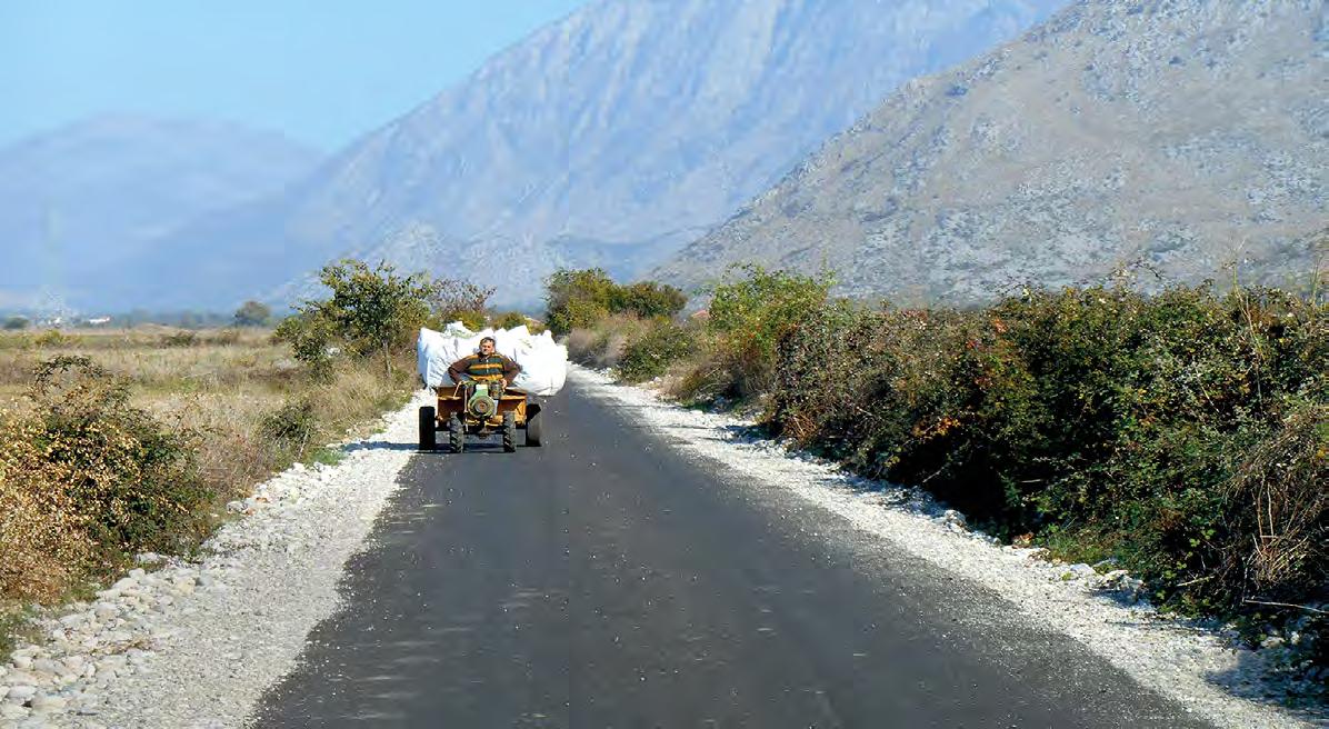
Rehabilitated road in Qender village. Supporting the Regional Agricultural Department of Shkodra to rehabilitate infrastructure, with particular focus on areas with high potential to cultivate medicinal plants and tobacco (O. Haub)
While numerous strategic documents were developed in the past to guide the development of Shkodra qark, there was no action plan to harmonize all these strategies. In 2010, the authorities of Shkodra qark initiated a future-oriented strategic process, assisted by the RDP, to coordinate and promote development in the region effectively. The process involved the following steps:
a) Identifying territorial potentials by analysing the existing Regional Development Strategic Concept [1] and the region’s economic patterns and territorial resources. The aim was to define the overall development goal and sectoral objectives towards regional development; central and local government institutions and socio-economic development partners in the region actively participated in the analysis. b) Identifying key development actors in the regions through an in-depth stakeholder assessment. The aim was to involve them in outlining development scenarios. c) Designating subregions with similar potentials and challenges as well as major sectors within these regions requiring development support as based on previous assessments. Four subregions and three major sectors (agriculture, tourism and environment) were eventually selected. d) Elaborating a development scenario for each of three sectors in the four subregions/territories together with the key development actors [2]. e) Determining development needs and specific interventions to achieve the development goals set out in the scenarios. f) Drafting a Regional Activity Plan to prioritize projects and identify funding opportunities for implementation. g) Supporting the implementation of Priority Projects by local government institutions in partnership with other socio-economic partners (spanning NGOs, the business sector, academia, vulnerable groups, etc.).
The Shkodra Regional Activity Plan identified 35 Priority Projects, of which 22 were already funded by the RDP’s grant scheme. These projects supported capacity building and employment of women in mountainous areas, small-scale enterprises focused on endogenous natural resources (medicinal herbs), mountain tourism through rehabilitation of existing infrastructure, and protection of the region’s natural habitat.
The Regional Development Programme is a joint and long-term effort to reduce disparities among Albania’s regions. It is implemented in partnership with GoA and co-funded by the Austrian Development Agency (ADA) and Swiss Agency for Development and Cooperation (SDC). RDP I (2010–2015) supported Shkodra and Lezha qarks in northern Albania, a mountainous area, in developing effective and participative mechanisms for regional coordination across all government levels based on a comprehensive review of the qarks’ potentials and competencies. RDP II (2015–2017) helped GoA to clarify and define the countrywide regional development approach and prepare guidance for the reform. RDP III (2017–2019) served as a preparation phase, setting up a legal and financial framework, piloting a grant fund mechanism and strengthening institutional capacities at regional and central level. RDP IV (2019–2023) supports the development and implementation of the national regional development policy and law through coordination of regional and local stakeholders, capacity building and financing of effective projects at the local level [3]. • Previously, large rural and mountainous areas of Albania did not benefit from development growth. Bringing decisionmaking closer to local and regional actors helped to address the regions’ development challenges. • Only projects with solid local support should be funded through regional development funds. Apart from guaranteeing local ownership, this makes benefits more likely to be felt by local people and society. • The experience of the Regional Development Programme in northern Albania shows that a development process designed with local and regional institutions, and based on a coaching approach, can lead to significant improvements in capacity and skills because of its practical orientation.

Promoting tourism in Albania’s mountain areas, Eco-Park in Shkrel village (O. Haub)


