
5 minute read
The Profile of an Appalachian Adventure | By Juan Sebastian Restrepo


The Profile Trail
An Appalachian Adventure
Advertisement
By Juan Sebastian Restrepo (Lees-McRae College graduate, Class of 2021)
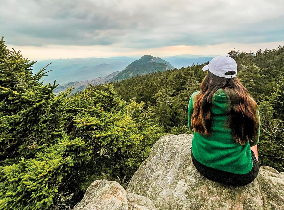
Sitting at the edge of Calloway Peak, with one’s feet hanging over the rock outcrop, it is hard to believe that Lees-McRae College is less than nine miles away down the mountain.
“This is gorgeous,” commented Laura Ocampo, a freshman Biology and Athletic Coaching student from Bogota, Colombia. Back in May, Ocampo joined me on a hike along the Profile Trail to Calloway Peak.
That evening, when we reached the peak, it felt as if we had been teleported to a dreamlike world out of a movie. An evergreen tapestry of spruces covered the mountain ridge as far as the eyes could see. At nearly 6,000 feet (1,828 meters) of altitude, a dense silence dominated over Grandfather Mountain, only interrupted by the song of robins, blue warblers, and wrens hidden in the thick forest.
This hiking trip was Ocampo’s first visit to the Profile Trail. The Colombian, who had enrolled in Lees-McRae in spring 2021, had few opportunities to discover the different outdoor experiences around the college during the academic semester.
“I never imagined that a place like this existed in the middle of these mountains,” said Ocampo, who throughout the twohour hike to Calloway Peak continued to express amazement at the scenery.
Making the Trip to the Profile Trail
The head of the Profile Trail is just a 10-minute drive from Banner Elk. Taking NC-184 S / Shawneehaw Avenue S towards Grandfather Mountain and turning left onto NC-105 N, the entrance is located half a mile away on the right-hand side.
There is no entry fee for hiking the Profile Trail. However, hikers must fill out a permit form found at the front building and carry the permit with them. At the entrance building, hikers can also find maps and pamphlets with other helpful information.
Once we completed our permit form, we were ready to start our adventure. We had 3.8 miles (6.1 kilometers) and 2,300 feet (701 meters) of climbing ahead of us to reach Calloway Peak. From the parking lot, Ocampo and I descended to the old trail. In less than one mile, we arrived at the bank of Watauga Creek. The shallow, crystalline stream induces visitors to remove their shoes and step into its cold waters.
Leaving the rocky shores of Watauga Creek behind, we began to ascend Grandfather Mountain. Mud and ankle-twisting tree roots covered this section of the trail. A kaleidoscope of colorful wildflowers decorated the surrounding hardwood forest. As we advanced, we encountered large as tall as 16 feet (5 meters).
Profile Trail has never stopped amazing me. Since the first time I hiked the trail with the cycling team at Lees-McRae back in fall 2019, no two visits have been alike. Either in the green summer or the yellow mid-fall, Grandfather Mountain will always find a way to surprise visitors with its scenery.
Ocampo could not refrain from stopping every few hundred feet to take a picture of the surrounding wildflowers and the tall beech trees. “I love this; I love breathing the forest and the flowers and walking along the creek bank,” said Ocampo.
Halfway to Calloway Peak, we reached Foscoe View. From this overlook, we had a panoramic view of the valley below to the northeast. Despite the thin fog mantle covering the mountain that evening, the Amphibolite Mountains were clearly visible on the far horizon. We could observe Snake Mountain, Elk Knob, The Peak, Whitetop Mountain, and even see as far as Mount Rogers, the highest peak in Virginia, located more than 60 miles away.
From this point, the trail turns rocky. The upper side of the Profile Trail is outlined by hundreds of large flat stones

forming a walkway up the mountain. It was impossible not to wonder how these huge boulders had been transported to this location. “This is probably the work of giants,” I joked as we hopped from rock to rock.
This section of the trail, named “Peregrine’s Flight,” was initially constructed between 1985 and 1989 by High Country locals Kinney Baughman and Jim Morton. Morton, who died in 2017, was one of the founders of the Woolly Worm Festival and chairman of the Grandfather Mountain Stewardship Foundation. With the help of Baughman, his long-time friend and a local brewer, Morton constructed this section of the trail in the ’80s using shovels, iron rods, and pulleys.
At this point, the vegetation began to change. As we moved into higher elevations, evergreen spruce trees started to dominate, replacing the beech trees and other hardwoods found at the bottom of the mountain. Rhododendron buds also prevailed on the upper side of the trail.
A mile away from Calloway Peak, we reached Profile View. Between two spruce trees, it was possible to see the outline of an old man’s face over the mountain. Appropriately, we could not walk any further without taking a picture of this iconic view of the cliff, which gives the trail its name.
As we continued our way up the mountain, we arrived at Shanty Spring. This spot is the last water source before Calloway Peak. The spring flows through a pipe on the ground. Spring water also drips from the massive boulders on the side of the mountain. We could not resist the temptation of drinking from the cold water pouring from the rocks above.
“I never imagined drinking water straight from a mountain spring,” said Ocampo as she recorded herself drinking.
Reaching the intersection of Grandfather Trail at 0.4 miles from the peak, we turned left. As we approached the summit, we passed by the Cliffside campsite on the right. Camping at this spot to watch the sunset has been on my bucket list for the past few months. Campers can reserve this site and other campsites at Grandfather Mountain State Park at www.reserveamerica.com.
Finally, we reached the last distance marker announcing that we were 0.1 miles from the summit. In this final section of the Profile Trail, we had to climb sets of wooden stairs to surpass the large boulders lining the rocky summit ridge. As we made our way along the ridgeline, we had a taste of the views awaiting us at Calloway Peak.
Turning right and climbing over one last boulder, a blue “X” spray-painted at the edge of the rock announced that we had arrived at our final destination. After two hours and 20 minutes of hiking, including stops, we summited Calloway Peak.
We sat at the edge of the flat rock and opened a celebratory Pop-Tart. The views over Calloway Peak invited us to pause from the rush of daily life and enjoy the peacefulness of the mountain.
It’s my last summer in Banner Elk and I knew I could not leave the mountains of North Carolina without a final trip to Calloway Peak. For Ocampo, this hiking trip was the first of many future Appalachian adventures. “I need to do this kind of adventure more often; I want to bring my parents here next time they visit me on campus,” said Ocampo.
Ocampo is excited to explore the almost unending list of other outdoor experiences around the Banner Elk area. In her upcoming years at Lees-McRae, Ocampo has the desire to live by the college’s motto—In the Mountains, Of the Mountains, For the Mountains.
One benefit of a Lees-McRae education is access to outdoor adventures that are mere minutes from campus. Find out more about the college’s outdoor experiential learning programs at lmc.edu.


