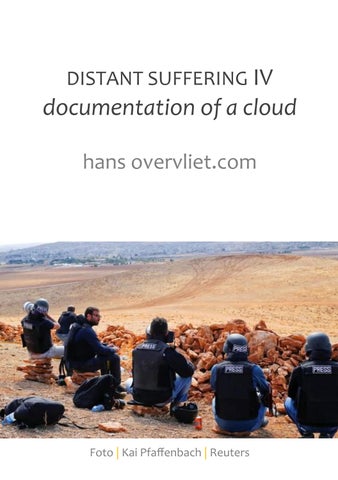
DISTANT SUFFERING IV
documentation of a cloud hans overvliet.com
Foto | Kai Pfaffenbach | Reuters
DISTANT SUFFERING IV
documentation of a cloud maart 2015
Hans Overvliet, beeldend kunstenaar www.hansovervliet.com | www.curiositas.nl Click here for my portfolio Click here for my C.V.
Six photographers, each representing a different international press agency, take up positions on a hill near the Mürşitpınar border crossing in Turkey—a vantage point overlooking the Kurdish / Syrian town of Ain al-Arab, just a short distance away. And so, they wait. The Syrian government has announced that it will carry out a bombardment that evening on Ain al-Arab. That is what they are waiting for. Then, late that night, the first strike hits. The six photographers trigger their shutters. Back at the hotel, over a good meal, they share their images, ensuring that each press agency receives a slightly different shot. However, because all the photographers used ultra-long lenses, the angle of every single photograph remains more or less the same . . . As a P.S.: At every exhibition where this work was presented, I invited the press in attendance to write about my disregard of the copyright on the photographs. I hoped that one of the press agencies would sue me. I wanted this because, in this instance too, the victims of the bombing have received no compensation—even though these press agencies, profit from the suffering of these local inhabitants of Ain al-Arab.
DISTANT SUFFERING IV | DOCUMENTATION OF A CLOUD the Kurdish / Syrian city Kobane / Ain al-Arab, seen from the southeastern side of the Turkish village of Mursitpinar / Mürşitpınar [ 36° 54' 14" North, 38° 20' 52" East ] in the Sanliurfa region Monday, October 20, 2014
Foto | Lefteris Pitarakis | AP Photo
DISTANT SUFFERING IV | DOCUMENTATION OF A CLOUD the Kurdish / Syrian city Kobane / Ain al-Arab, seen from the southeastern side of the Turkish village of Mursitpinar / Mürşitpınar [ 36° 54' 14" North, 38° 20' 52" East ] in the Sanliurfa region Monday, October 20, 2014
Foto | Bulent Kilic | AFP Photo
DISTANT SUFFERING IV | DOCUMENTATION OF A CLOUD the Kurdish / Syrian city Kobane / Ain al-Arab, seen from the southeastern side of the Turkish village of Mursitpinar / Mürşitpınar [ 36° 54' 14" North, 38° 20' 52" East ] in the Sanliurfa region Monday, October 20, 2014
Foto | Lefteris Pitarakis | AP Photo
DISTANT SUFFERING IV | DOCUMENTATION OF A CLOUD the Kurdish / Syrian city Kobane / Ain al-Arab, seen from the southeastern side of the Turkish village of Mursitpinar / Mürşitpınar [ 36° 54' 14" North, 38° 20' 52" East ] in the Sanliurfa region Monday, October 20, 2014
Foto | Gokhan Sahin | Getty Images
DISTANT SUFFERING IV | DOCUMENTATION OF A CLOUD the Kurdish / Syrian city Kobane / Ain al-Arab, seen from the southeastern side of the Turkish village of Mursitpinar / Mürşitpınar [ 36° 54' 14" North, 38° 20' 52" East ] in the Sanliurfa region Monday, October 20, 2014
Foto | Kai Pfaffenbach | Reuters
DISTANT SUFFERING IV | DOCUMENTATION OF A CLOUD the Kurdish / Syrian city Kobane / Ain al-Arab, seen from the southeastern side of the Turkish village of Mursitpinar / Mürşitpınar [ 36° 54' 14" North, 38° 20' 52" East ] in the Sanliurfa region Monday, October 20, 2014
Foto | Gokhan Sahin | GettyImages
DISTANT SUFFERING IV | DOCUMENTATION OF A CLOUD the Kurdish / Syrian city Kobane / Ain al-Arab, seen from the southeastern side of the Turkish village of Mursitpinar / Mürşitpınar [ 36° 54' 14" North, 38° 20' 52" East ] in the Sanliurfa region Monday, October 20, 2014
Foto | Kai Pfaffenbach | Reuters
DISTANT SUFFERING IV
documentation of a cloud
hans overvliet.com