Consultation on the National Development Plan Review 2025 –

Author – Dan Harty
Consultation on the National Development Plan Review – Bypass For Thurles Submission.
National Development Plan 2026 – 2035
Bypass For Thurles
Bypass For Thurles is a campaign group that was founded by Dan Harty following a public meeting in Hayes Hotel Thurles on January 11th 2024. The campaign group was formed by local residents from Thurles who wish to see the Thurles Bypass project progressed and to be included in the National Development Plan following its 2025 review. Following several research engagements, this submission was produced to make a case for this project to go ahead.
Introduction / Background to project – Thurles Bypass
Thurles, Co. Tipperary is a thriving market town in the heart of the county, situated in the Tipperary North Dáil constituency, with a recorded population of 8,185 according to the 2022 census. The town centre, Liberty Square is defined by and dominated by the fact that it sits at the intersection of two National Roads (N62 & N75). For decades Thurles has been subject to significantly high volumes of traffic from both National Roads, including significant HGV and agricultural traffic, and when added to local daily traffic, significant congestion results. This congestion has in the past and continues to restrict the development of many aspects of Thurles town.
A ring road or bypass for Thurles has been mooted as far back as the 1950’s and continues to be seen by local businesspeople, politicians, the Local Authority, and the public as the key solution to unlocking the true potential of the town. Without this key infrastructural project, transport issues in Thurles will remain unresolved and all other measures will amount to nothing other than tinkering around the edges.
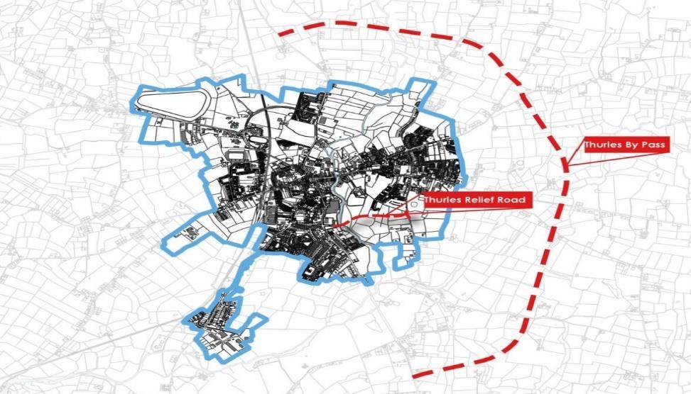
In 2011, an 8km preferred route for a Thurles bypass was published by Tipperary County Council. The route, on the eastern side of the town from Brittas to Turtualla would link the N62 north of the town to the N75 south of the town. There was great optimism locally at this time that a solution was finally in the pipeline, but this soon turned to disappointment when it became clear that the Thurles Bypass project was not included in subsequent reviews of the National Development Plan, with the lack of funding due to the economic crash sited as the reason for its omission.
In 2025 however there is renewed optimism locally that the time has come for the Thurles project to be prioritised and to be firmly put back on the agenda. Congestion issues remain and the rollout of Local Transport Plans, town centre development and viability of businesses operating in the town centre are heavily reliant on this issue being resolved. The economic landscape has changed since the Thurles Bypass project was omitted from the 2014 review of the NDP and with the commitment by government that this latest review will encompass all public capital investment and use both Exchequer and non-Exchequer sources of funding, including the Apple Escrow funds, the Infrastructure, Climate and Nature Fund and the proceeds of the AIB share sales, the Thurles Bypass project, having been shelved through the economic downturn, will now have its day in the sun.
Thurles Local Transport Plan
The most recent Local Transport Plan published by Tipperary County Council identified an Emerging Preferred Strategy for road options, which incorporated feedback from the Baseline Assessment phase that included a public consultation phase. The section below in italics is taken form the Thurles Local Area Transport Plan and clearly outlines some of the issues facing the town and concludes that that the preferred solution is for a bypass.
It is clear that the presence of a significant volume of through traffic on both national roads leads to a heavily vehicle dominated town centre and prevents Thurles achieving an environment which is more amenable to walking and cycling. The congestion within the town centre also restricts the operation of an efficient bus services and detracts from the creation of a liveable urban centre. As such, the LTP is recommending a bypass to the town to help alleviate the impact of through national road network traffic and create a better town centre environment in Thurles. The town bypass included in the Emerging Preferred Strategy is an eastern bypass which connects both national roads, the N62 (in two locations, north and south of the town) and the N75 to the east. In combination with the Jimmy Doyle Road, it will also provide a full orbital connection between the N62 South, N75 and the R498 Nenagh Road.
The following section is an assessment of the scheme under the sustainable principles of road development, which are mentioned above.
• Re-allocate Road Space: A modelling assessment of the road scheme was undertaken and indicated that the road will substantially reduce traffic flows through the town centre. In particular, traffic over the River Suir bridge reduces by 55% with the bypass in place. This substantial reduction of through traffic within the town centre helps create a calmed environment which is more conducive to pedestrian and cycle activity, thus supporting the reallocation of road space to sustainable modes. In particular, the delivery of the eastern bypass could also facilitate turning Bohernanave into a one way traffic system in order to facilitate segregated cycle facilities. This would provide an on-street facility between the R660 and the R498 thus linking the train station, the Gaelscoil, Colaiste Mhuire and the TUS campus. It could also facilitate turning Parnell Street (between Liberty Square and Cuchulain Road) into a one-way traffic system, in order to provide segregated cycle facilities, directly into Liberty Square, but such proposals are not possible with the current traffic volumes in the Town centre.
• Safety: In addition to supporting the reallocation of road space to active travel modes, the bypass would also enable a HGV ban (whilst still allowing deliveries) in the town centre as it would provide an alternative route for HGVs who don’t need to travel through Thurles. This would greatly improve the safety for pedestrian and cyclists as the current town centre road network layout (around Liberty Square) is too narrow for some HGVs, who have to drive on footpaths at certain locations in order to travel through the area.
• Multi-modal: By removing the strategic traffic from the town centre (55% reduction over the River Suir bridge), a bypass would also enable journey time reliability for public transport users to be improved. As such, it would increase the attractiveness of public transport in the area.
• Alternative Solutions: The framework for developing solutions to transport problems comes from National Investment Framework for Transport in Ireland (NIFTI) and begins with the Modal Hierarchy. This means that travel needs should be served first and foremost by walking & cycling, then by public transport, and finally road-based solutions as a last resort. In the case of Thurles, active travel infrastructure could result in the removal of some local ‘short distance’ car trips but
would have no effect on long distance trips using the national road network. Active travel infrastructure would also have no effect on goods vehicles. Public transport measures could alleviate some traffic from the town centre but given the dispersed nature of travel movements in the area and the high modal split of cars, it is unlikely to achieve the effect needed to reduce traffic in the area. Public transport would also have no effect on goods vehicles movements. As such, given the specific issues in Thurles regarding strategic through traffic, the road-based option is the only solution that will substantially reduce traffic volumes in the town centre and allow for the reallocation of road space and the creation a safer environment for pedestrians and cyclists.
Safety, Congestion, Unlocking Potential
The assessment above highlights numerous safety concerns in Liberty Square, particularly concerning pedestrians and cyclists when faced with high volumes of HGV traffic. The narrow streets of Thurles are unsuitable for high volumes of heavy goods traffic. Each connecting street to Liberty Square represents a danger for pedestrians and cyclists, this is due their narrow nature, the unsuitability for heavy goods traffic and the lack of pedestrian crossings. Each connecting street poses its own unique dangers and problems. This includes O’Donovan Rossa Street, Parnell Street, Friar Street, Slievenamon Road, Cathederal Street (and Emmet Street).
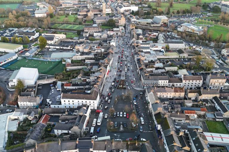
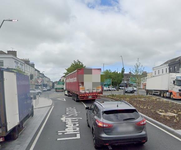
The busy N62 southbound traffic must enter Liberty Sq via O’Donovan Rossa St, a one-lane narrow street where large lorries can barely fit through. Turning on to Liberty Square at this point is a very dangerous manoeuvre where accidents, near misses and congestion is commonplace.
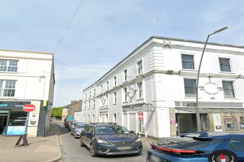
Parnell Street is a two-lane access point to Liberty Sq with significant traffic from R498 (Nenagh) and traffic from the N62 (Via Jimmy Doyle Road and Cuchulain Road). Parnell Street sees daily traffic congestion due to its narrow nature, having on street parking and a narrow bottle neck at the point where it joins Liberty Square. It is a busy route for strategic through traffic and local traffic as an access to local schools, university, sports facilities, and places of work (Scoil Ailbhe, Scoil Mhuire, Gaelcsoil Bhríde, Ursuline Secondary School and CBS Secondary School, Semple Stadium, TUS campus and the Racecourse Retail Park to name but a few).
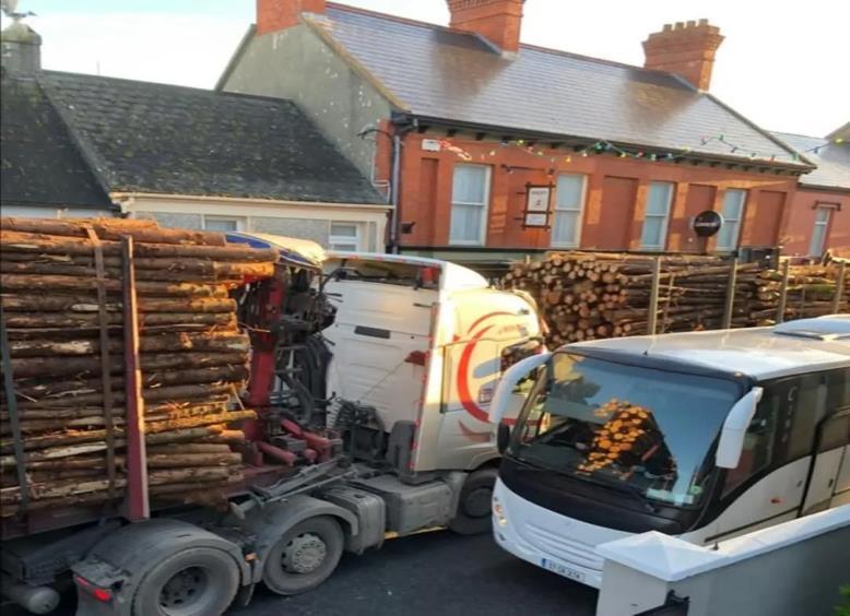
Friar Street is a narrow two-lane street that enters Libery Square at the West Gate. The street is very narrow at this point, lacks any pedestrian crossing and poses a significant traffic hazard to vehicles traversing Liberty Square, where the rules of the road and layout often leaves drivers confused causing further danger and congestion.
Slievenamon Road / The Mall (N62) southbound to the Horse and Jockey / M8 is the busiest National Road that intersects Liberty Square. It is a two-lane street that carries huge volumes of strategic through traffic with a weekday average traffic count of nearly 5,000 journeys both northbound and southbound, including average weekly HGV traffic of roughly 1,700 vehicles both northbound and southbound. This road also carries large volumes of local traffic that is not picked up by the traffic counter, the road connects to large residential areas, Thurles Shopping Centre, Lidl and various other amenities and places of employment. This street intersects Liberty Square at a very busy junction, where space for large HGVs is at a premium, this issue is highlighted by the frequent damage done to barriers erected to prevent pedestrians entering the street.
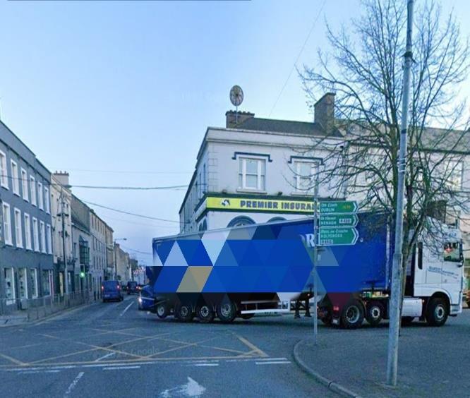
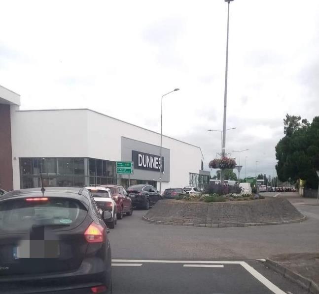
The entrance to Liberty Square’s eastern end at the River Suir Bridge (Barry’s Bridge), Cathederal Street, joined by Emmet Street represents a major bottle neck for traffic in Thurles. Amazingly, in 2025 the ancient River Suir Bridge (built c. 1600, reconstructed c. 1820), remains the sole river crossing point for vehicles in the town. It carries huge volumes of strategic through traffic, agricultural traffic, and local daily traffic. The entrance to Liberty Square at this point is dominated by Barry’s Castle, an ancient ruins and access for traffic and pedestrians is restricted at this point. There is no pedestrian crossing at Emmet St, where visibility for drivers is poor or non-existent and the nearest pedestrian crossing on Cathedral Street is between the Cathedral of the Assumption and the MIC campus. Huge volumes of local traffic must cross the River Suir Bridge multiple times daily, for school transport, employment, sports, recreation and shopping to name but a few, traffic congestion is compounded by strategic traffic accessing the N75 & M8. Traffic modelling conducted by Tipperary County Council has estimated that a bypass for Thurles would reduce traffic on the River Suir Bridge by a significant 55%. The proposed Thurles Inner Relief Road (providing a second bridge point over the River Suir) will on completion reduce traffic by 15% at this point. The Inner Relief Road is welcome but cannot be accepted as an alternative to a full bypass, it must be utilised as a
complimentary measure to the bypass as a traffic calming measure for local traffic and an interim traffic calming measure before the bypass is built.
Due to the congestion and conditions faced by the public in Liberty Square and adjoining streets, all aspects of development in the town are hugely restricted.
Active Travel Plans
Tipperary County Council have admitted in their Local Transport Plan that the planning, implementation, and take-up of a successful long-term active travel plan for Thurles is extremely hampered by current conditions and that a bypass is the ultimate solution to the problem. Having a functioning bypass in place would be a complete game changer for town planners and would open the potential for Thurles as an active travel town. Active travel in Thurles makes sense, with two university campuses, four primary schools, four secondary schools and many services and places of employment located in the town. The restricted nature of travel in the town due to congestion, ensures a reliance on motor transport, that feeds into the existing issues and adds to town centre pollution.
6.5 Road Network Local. Transport Plan.
The under investment in road infrastructure in Thurles over a number of decades has led to excessive levels of congestion within the town, impacting on the economic vitality of its centre and quality of life for its residents. Whilst the LTP focusses on the delivery of short-term active travel solutions, the level of strategic traffic passing through the centre of Thurles on both the N62 and N75 poses a significant challenge to the implementation of active travel measures in the town centre, limiting the uptake of walking and cycling amongst residents.
Pedestrian and Cyclist Safety
The reality is that Thurles town centre is not a safe place for pedestrians and cyclists. It’s with deep regret that the town has witnessed multiple fatalities on its streets over the years. Accidents and near misses are unavoidable and common place. For the elderly, people with disabilities and young children, traversing the streets of Thurles is a daily challenge. This is unacceptable and must be paramount when plans for the town are considered. Removing the heavy goods traffic that often mounts footpaths to pass oncoming traffic must be achieved and can only truly be addressed by providing an alternative route for strategic through traffic.
Town Centre First Policy
Thurles is designated as a ‘Key Town’, meaning it will follow a town centre first development approach. The Town Centre First initiative is central to government plans to regenerate rural towns, tackle dereliction, vacancy, and create town centres that are viable, vibrant, and attractive locations for people to live, work and visit. Significant upgrades and investment have been made and are planned for Liberty Square and adjoining streets. This is all very positive, but if future ambitions are to reach their full potential or be viable in Thurles, it is clear that transport issues must be addressed.
In the case where a fully functioning bypass is in place, the potential for Thurles is huge in this regard. It would make the town centre an even more attractive place to shop, do business and live. It would be very advantageous to existing business and open huge potential for growth. If the chokehold of traffic was removed, the potential for the future development Thurles town centre is unlocked.
6.5 Road Network Local. Transport Plan.
In keeping with the ‘Town Centre First’ approach, there is a need to reinvigorate the centre of Thurles through appropriate investment in national road infrastructure in tandem with the reallocation of road space for active modes, public realm enhancements and public transport in the town centre. This integrated approach to the delivery of transport infrastructure will support the compact growth of Thurles encouraging future businesses and residents to locate in the heart of the town.
Traffic Figures – Transport Infrastructure Ireland Traffic Count Data – 2024 data figures
See below some of the raw data figure for traffic flow into and out of Thurles on a daily, weekly, and annual basis. Data is taken from Transport Infrastructure Ireland (TII) fixed traffic counters. Please note that there is no data available for the R498 (Nenagh Road), the main route that connects the two largest towns in the Tipperary North constituency. It is also worth noting that the Bypass route would service the R498 via the Jimmy Doyle Road.
N75 - Between Thurles and Twomileborris, Co. Tipperary
Station ID: TMU N75 000.0 E
N62 - Between Thurles and Horse & Jockey, M08 Jn06 Thurles, Knockroe Co. Tipperary
Station ID: TMU N62 050.0 S
N62 - Between Thurles and Templemore, Whitefield, Co. Tipperary
Station ID: TMU N62 080.0 N
Potential for Development
A fully functioning Bypass would have many immediate benefits for the town of Thurles. It would also open up huge potential for development, commercial, industrial and residential. Thurles has lost many industries over the past few decades. As a very accessible town, close to a national motorway and on the main Dublin – Limerick / Cork train line this is very disappointing. Attracting new industry to the town has proved difficult and unattractive to investors. Removing the huge levels of congestion in the town would remove one of the main barriers for investment Having adequate and efficient local transport infrastructure in place is crucial for attracting investment and fostering economic growth.
The proposed 8km Bypass would provide the Thurles locality with huge potential for development by providing access to large tracts of land that may be suitable for future re-zoning. Thurles at present is facing an accommodation crisis, with large council waiting lists, lack of student accommodation and a large volume of pent-up demand for housing. Frustratingly, several recent planning applications for residential developments have been denied. The potential for development on lands that would become accessible by an 8km bypass would be transformative for Local Authority planners.
Conclusion
It is clear that a Bypass for Thurles town would be beneficial in many ways. Not only would it alleviate the daily traffic congestion for locals and people passing through, but it would potentially revolutionise transport in the town. Ambitious active travel measures would become possible, local public transport solutions such as a town bus service or a town school bus would become viable options. Conditions for existing business in the town centre would be dramatically improved and growth of new business would become far more attractive.
The Town Centre approach to planning would inevitably make more sense and investment in local streetscapes and infrastructure would have the opportunity to live up to their potential.
Perhaps most importantly, the town centre would become a far safer place for citizens to travel and enjoy. Let’s make Thurles a town a vibrant and attractive location for people to live, work and visit.
The Bypass For Thurles campaign group is calling for this submission to be seriously considered and for the Thurles Bypass project to be put back on the National Development Plan as part of this review.
Go raibh maith agat.