
8 minute read
Organising your sites in DemOn


When you first look at your sites in DemOn, they will appear as multiple overlapping squares.

With the arrival of DemOn came the possibility of organising your ringing and nest recording sites to better represent the locations as they are on the ground. This offers a degree of personal satisfaction but, more importantly, enhances the quality and usefulness of your data, past and present, to your own projects, to conservationists and science. Here, Graham Austin provides some real-life examples to illustrate how you can tidy up your existing sites in DemOn.
DemOn allows you to define site boundaries and sub-sites (sub-areas, individual net-lines, point locations, nests or nest boxes) precisely. This is a giant leap forward from the location of a site being defined at best to somewhere within a given 1-km grid square with subsites somewhere (known only to yourself) within that site.
When you first view your sites in the DemOn map interface it can be quite eye-opening as to how imprecise the spatial information attached to your records has actually been. For those with a long commitment to ringing or nest recording, the maps based on the best information available to BTO can lead to what can only be described as a nightmare of overlapping squares of 1 km or greater, some of which appear to be duplicated, that has no doubt sent many running for the hills. Duplication of sites is primarily due to small discrepancies / tweaks over the years in site information received. Not previously being able to define site boundaries more precisely has also led to multiple locations being defined using the same grid reference.
You’ve always been able to use DemOn to submit ringing encounters and nest records, even if you left your sites as you found them, because IPMR place and subsite codes were used as defaults for DemOn location codes. Now though, DemOn contains tools that allow you to tidy up your sites. While still no small task for some, it is nonetheless a one-off task.
RINGING SITES A ringing site can mean different things to different people. It may be that you have simply used a given 1-km square grid reference, maybe with an associated accuracy for any and all ringing activities within that square, or you may have used sub-site codes to distinguish between different ringing sites within it. It may be that your site has very precise boundaries within which you may have used subsite codes to define specific sub-areas, different nets or net-rides or the locations of traps. Pre-existing sites first appear in DemOn as a stack of 1 km squares – one General Site (GS; derived from the IPMR Place) and any number of Encounter Areas (EAs; derived from the various IPMR subsites). In DemOn however, you can define all of these locations precisely.
FURTHER INFO The DemOn Manual (available under the DemOn Help menu) contains step-by-step guidance for using all the editing tools discussed in this article.


Left: Example 1 – garden site. Middle: Example 2 – ringing site with a CES (green) is a Wildlife Trust nature reserve comprised of waterbodies, multiple reedbeds and other habitat compartments. Right: Example 3 – close up of the CES site from example 2.

NEST BOXES DemOn offers the ability to pinpoint the location of nest boxes and other nest sites that are occupied every year, such as raptor eyries, bridges, buildings and other artificial structures, with GPS accuracy, which when coupled with a descriptive name or comment can be very useful for collaborations between ringers and/or nest recorders.
Example 1 above is a private garden and it goes without saying is not well represented by a stack of 1-km squares. The first job was to select each of the EAs in turn and use the ‘Change Location Type’ tool to make four of them into nets and one of them into a trap and, at the same time, define their exact positions by tracing them onto the map. There was also a duplicate EA to get rid of. Having used the ‘Change Location Type’ tool to turn that EA into a net, the ‘Remove Duplicates’ tool was then used to transfer all its associated captures to the version being retained before deleting it.
Having dealt with the ex-subsites, the ‘Edit Geometry’ tool was then used to redraw the original 1-km square to precisely match the garden boundary. Finally, a couple of extra nets and a nest box were added using the appropriate ‘Create Tool’ options. The overall garden (the GS), three nets and the trap, each a location in their own right, all belong to the garden’s location group.
Example 2 above is a ringing site used for opportunistic ringing, nest recording and a CES. This site first appeared in DemOn as a GS, derived from the IPMR Place, and had multiple EAs derived from subsites representing distinct habitat compartments or CES nets. As the site overlaps with several 1-km grid squares, an accuracy of ‘1’ had been used in IPMR and so the GS and associated EAs first appeared as 3 x 3-km squares. DemOn had also automatically created a CES location group comprised of a catch-all and four EAs representing the four subsites against which historical CES captures had been submitted.
The first job was to deal with the CES (green polygon; example 3 above) by using ‘Change Location Type’ to convert the EAs into nets. Subsequently, the boundary of the CES catch-all was redefined using ‘Edit Geometry’. The next task was redefining the boundaries of the EAs representing distinct habitat/management compartments; they were left as EAs because within these there are no permanently established net-rides. After that, the true boundary of the GS was redefined using the ‘Edit Geometry tool’, a considerable improvement over the 3 x 3-km square. There were also some duplicate EAs to remove using the ‘Remove Duplicates’ tool. Finally, several new EAs were created using the appropriate ‘Create Tool’ option; these overlap with existing EAs but were flagged as being confidential, consequently only visible to selected group members, and available to record captures of sensitive species should there be any.
NEST-BOX SCHEMES Example 4 (opposite) is a site where nests are monitored by a number of different ringers and nest recorders. The site first appeared in DemOn as a GS with no subsites listed in the location group (the original IPMR
place had no subsites), the box numbers having been recorded in a user own field. As this site had overlapped several 1-km grid squares and so been given an accuracy of ‘2’ in IPMR, it first appeared as a 5 x 5-km square. The ‘Edit Geometry’ tool was used to redraw the boundary of the GS to follow the boundary of the reserve. The GS was still more extensive than the maximum allowable for recording nest records and ringing encounters, unless providing coordinates on the fly, but for fixed-position nest boxes it was more appropriate to create the nest boxes as nest sites based on GPS coordinates (10-figure OS or Lat/Long to at least six decimal places).
Creating all the new nest locations was a lengthy but one-off task, taking over an hour. The nest record defaults and habitat had previously been completed for the GS so, as the nest sites were created and added to the GS’s location group, they picked up all the defaults from the GS; the defaults only needed editing for a few nest boxes. The location codes were made to match the nest box numbers to make it easier to identify each one. The ‘Reporting Name’ (under ’Ringing Defaults’) was kept the same for all nest boxes, although the ‘Name’ (under ‘Location Details’) is descriptive, including box number and sometimes a landmark. Having created all the boxes, the ‘Clone locations to another account’ tool (under ‘Advanced Tools’) was used to copy the GS’s location group in its entirety to both the other ringer and the nest recording group. This allows either ringer to use their own rings and link the pullus and adult captures to the nest records in the nest recording group account using the ‘Link’ functionality found in nest record and ringing data entry.
‘PATCH’ NEST RECORDING AND RINGING DemOn gives you the ability to pinpoint nests and one-off ringing locations as ‘unremembered’ locations within a GS. This is done on-the-fly by using the ‘Refine Location’ option for the location field during data entry. These locations are only unremembered in the sense that they cannot be used again to record additional ringing encounters or to create another nest record. Encounters or nest records with refined

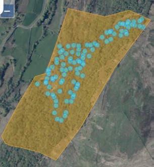
Left: Example 4 – an RSPB reserve with approximately 100 nest boxes. Right: Example 5 – a patch covering 12 square km.
locations show the GS as the location but, critically, with the pinpoint grid reference.
This is a large site, a patch covering 12 square km – this area is used for nest recording and for several studies involving the ringing of territorial birds, the latter including part coverage of a RAS. This site did not exist in IPMR as previously each 1-km square in this area was treated as a Place (20 in all).
The ‘General Site’ tool (under ‘Create Tools’) was used to create a new GS by tracing out the boundary of the forestry block. Because this is an extensive site (maximum diagonal dimension exceeds that of a 1-km square; >1.41 km) DemOn will not allow nest records or ringing encounters to be recorded without using the refine location option on-the-fly during data entry. This is ideal for pinpointing nests or captures of territorial birds by entering GPS coordinates during data entry. Permanent nest sites (e.g. nest boxes or natural raptor/ owl nests), or regularly used ringing spots being added as EAs, nets, traps or nest sites, can still be included as components of the GS’s location group. Together with the new GS, the 20 1-km square GSs derived from IPMR Places have been added to a Reporting location group in order to facilitate long term reporting. The 20 1-km squares were then archived using the ‘Archive Tool’ (under ‘Advanced Tools’) to prevent them being selected during data entry and to hide them in Map and List Views of Site Management. If needed they can be unarchived at any time.


