15 minute read
TOURISM IN “UNA” NATIONAL PARK

Habitats and Eco-systems
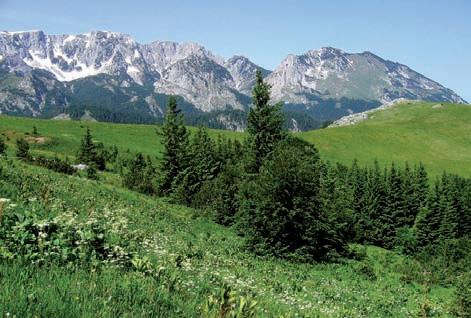
Land habitats in the Una NP consist of meadows, pastures and woods. e major section of the National Park is overgrown with various types of woods, including climazonal, extra zonal and a zonal. e pastures in the national park are permanent anthropogenic conditions/stadium and can be maintained only by means of indirect (cattle-grazing) and direct (mowing) anthropogenic in uences. e area abounds in calcareous rocks inhabited by hazmophytic plants (plants growing in ssures or cracks). As a result of the hydrospheric and atmospheric in uences, fragments of the rocks break o from massive cli s and roll down the slopes, creating a funnel like slopes. On higher elevations above the canyon, on the at terrain with thick earth grasslands of the Brometalia erecti order have developed in places. Water habitats encompass the area along the rivers of Una and Unac. e rivers themselves don’t have well-developed macrophyte vegetation in the areas researched, but only sporadically in some small serene lagoons.
Advertisement
Wet habitats in the explored area are represented by humid and wetland grassland, tall herbaceous plants and reeds. Along the Una River, there are well developed hydrophilic communities of wood and the beds of purple-willow, alder and common sallow. Given their peculiar environmental conditions, the habitats on gypsum waterfalls represent a biotope that is quite di erent from all other fresh-water habitats.
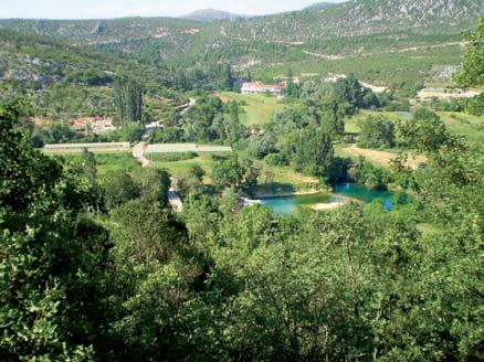
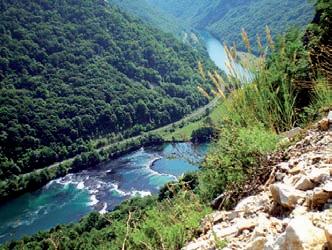
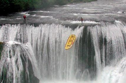
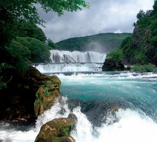
On the waterfalls, apart from tall herbaceous plants and diatomei, a total of 42 plant species, including 25 types of algae and 17 types of moss, were found. erefore, the majority of these plants are sporophytes and only a few are asporophyte. e rivers of Una, Unac and Krka, three gems of natural heritage in the crown of the Una NP, are a mixture of diverse and well-preserved landscape of exceptional beauty and rich cultural and historic heritage. e Una River, as the greatest natural treasure, has lent its name to the national park/ a er which the national park was named. It springs in the village of Donja Suvaja at the foothills of Mount Čemernica in Croatia. is is a typical karst spring of upward/ascending type and emerald-blue color. In the upper section of the river, from its spring to Bihać, the overall fall is almost 3 m per kilometer. In this part, Una has all the characteristics of a mountain river and its gypsum barriers, cascades and waterfalls are real gems of nature: the Martin Brod waterfalls, waterfalls are real gems of nature: the Martin Brod waterfalls, Štrbački Buk, Troslap, Dvoslap and Ripački waterfalls. Štrbački Buk, Troslap, Dvoslap and Ripački waterfalls. e water rushes down the waterfalls in Martin Brod e water rushes down the waterfalls in Martin Brod and Štrbački Buk along several small and big barand Štrbački Buk along several small and big barriers, forming along the way gypsum-structures riers, forming along the way gypsum-structures of exceptional beauty. e Una River hides an of exceptional beauty. e Una River hides an interesting wildlife that is also involved in the creation of gypsum barriers. Because of its speci c structure, moss or bryophyte, retains calcite deposits and thus makes an indispensable link in the process of formation and growth of the gypsum structures. e Unac River springs as a water-mill brook below Mount Šator at 876 m elevation point and ows on through the Pojila cli , four steep valleys and three more cli s. e section of the Unac River that runs through e section of the Unac River that runs through the National Park to Martinbrod passes through the National Park to Martinbrod passes through one of the tightest cli that is 350 m deep in places. one of the tightest cli that is 350 m deep in places. e total length of its course is 66 km, with an altitude e total length of its course is 66 km, with an altitude di erence of 450 m. e river is the rst signi cant tribusigni cant tribu-


tary of the Una River, cooling it down and ennobling with its exceptional pristine and freshness. Along its entire course, the Unac River is fed with water from a dozen di erent streams and springs. In summer, due to the reduced in ux of water from the surrounding forest streams, it can dry up in places, leaving behind small isolated ponds full of sh. Along this section of its course, the river sinks under the ground and surges back to surface at Crno Vrelo, some 3 km before its con uence with the Una River. e Krka Rivulet ows through the National Park in the entire length of 5 km, meandering along the border with Croatia. It surges from under the plateau of the village of Mali Cvjetnić, powering an old water-mill at its spring. is is an eye-catching sight, but the access to the spring is very demanding, which makes a great opportunity for a whole-day outing that includes a walk through the woods along a hilly mountain terrain, down to the rivulet’s riverbed. e descent o ers rare moments of enjoyment in the beauty of unspoilt nature. Some sections of the Una and Unac rivers are one of the best y- shing beats in Europe, while the Una River itself is a genuine paradise for all lovers of angling by dry- y method with a water-ball and wobbler suhe mušice sa vodenom lopticom i varaličarenjem.
Flora of the Una National Park

e con guration of the terrain and geo-morphological structure of the soil in the Una National Park, varying sea altitude, diverse plant wildlife and micro-organisms, together with other life forms, all contribute to an exceptionally rich biodiversity of the park. e area contains a large number of rare and endemic plant species as follows: Gentiana lutea, Gentiana punctata, edelweiss (Leontopodium alpinum Cass.) and juniper wood (Pinus mugo). e park’s endemic species are Campanilla unensis, named a er the Una River, and Bosnian iris (Iris reichenbachii Heu el var. Bosniaca) which grows on dry meadows and pastures on carbonate and serpentine rocks with shallow soil. Bosnian iris is an endemic species of the central and southeast Dinarides. Local environmental conditions have favored the development of a large number of diverse plant communities with over 1,900 species, which makes 52,19% of all oral species in Bosnia and Herzegovina. In this region, 177 o cially con rmed medicinal herbs and 105 possible medicinal herbs and edible, vitaminrich and aromatic plant species have been registered. e terrain of the National Park is built of calcareous rocks overgrown with vegetation that has adapted to the speci c conditions of this type of habitats such as hazmophyte plants (plants growing in ssures). Weed and mineral-building vegetation grows along all settlements in this area. e communities of the order of Bidentetea, Artemisetea and Chenopodietea are well developed thanks to the rural way of living, extensive agriculture and cattle-breeding.
Diverse habitats abound in a large number of species and communities. It is impossible to give the exact number of the herbal communities in the Park, but a comparison can be drawn with, for example, Austria,
which is said to have some 2,000 plant species, while according to estimates, the spatially small area of the park has over 1,000. Besides, the area contains many endemic and relict-refuge communities that are important not only for the area itself, but also for the overall biodiversity of Europe. erefore, it can be expected that a large part of this area will be included in Natura 2000 project.
Fishing
As in any other place in the world, where people live by the water, shing has been a widespread traditional activity in the area of the Una NP ever since the time of Japod. In more recent times, sports and recreational shing is the most popular pastime with all nature lovers who come to the National Park as tourists to enjoy y shing and other shing methods that are common and allowed on the cool and clear water streams of the Una and Unac rivers. With the proclamation of the Una National Park, whereby sections of the Una, Unac and Krka rivers have been protected, the intention of the legislator was not to impose a strict regime of shing ban, but to incorporate shing activities into protective measures envisaged as primary tasks, and into the overall tourist o er of the Park, the municipality of Bihać and the region on the other hand. On some sections of the river courses, there are organized shing routes as follows:
- 2 y- shing routes on rivers Una and Unac; - 2 routes for angling by wobbler and water-ball method with maximum 3 arti cial dry ies on the Una river, and - 1 shing route that combines the above two methods within shing route no. 1 on the Una river. e y- shing routes on rivers Una and Unac are well-known to many shing enthusiasts from the region and entire Europe, but now new shing-regime regulations have created conditions for further popularization of this sport on the two rivers. In that context, we proudly announce the merging of 2 existing y- shing routes into a one-of-a kind shing route in the region and the opening of an altogether new y- shing route as follows: - Route no. 1 from Martin Brod to Kulen Vakuf, in the length of 12 kilometers,
- Route no.3 from Bjelila to Loskun, in the length of 3.5 kilometers.
In addition, 2 new shing routes for the enthusiasts of y- shing by wobbler and by water-ball method with maximum 3 dry ies have been opened:
- Fishing route no. 2 from Ćelije to Klisa, in the length of 14.6 kilometers, - Fishing route no. 2 at Dvoslap, in the length of 5.7 kilometers,and a combined shing route where y- shing and shing by water-ball method with maximum 3 dry ies are allowed. - Combined shing route no. 1A "Palučci", the length of 3 km lies within shing route no. 1 ( shing is allowed in the period from 15 May to 30 September). e most frequent sh species found on the afore-mentioned shing routes include: - Brook trout (Salmo trutta), its shing season lasts from 1 March to 30 September, - ymallus thymallus, its shing season last from 1 May to 30 September.
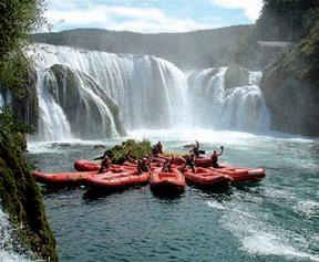
Ra ing and canoeing
Ra ing and canoeing, the most exciting and most frequently practiced sports and recreational activities on the streams of the Una National Park, are organized by several exceptionally well-run ra ing agencies that will o er you an unforgettable ride down the most attractive section of the Una River from Štrbački Buk to the village of Lohovo. e route extends through the National Park in the length of 15 km. During high water season, in April and May, the water di culty on the Una River is between 3 and 5 degrees. e rst section of the route is long, wild, unpredictable and full of rapids that create many whirlpools and waves. During medium-high water season, the water di culty varies between 2 and 4 degrees. At this time, the ride is rough and di cult past gypsum rocks of teeming water, down strong currents and around sharp bends. An adrenaline rush is guaranteed and desirable, enabling ra ers an authentic experience of the ride down this river. Weather-permitting, the ra ing season on the Una River lasts from March to October.

e Recap: Basic characteristics of the route:
ŠTRBAČKI BUK - LOSKUN - LOHOVO (15 km)
Water di culty varies between 4 and 5 degrees (1st section) Water di culty varies between 1 and 2 degrees (2nd section) e ride lasts some 4 hours.
Water temperature: 13 -17 degrees Celsius
An additional attraction for the visitors are skipper jumps or leaps at Štrbački Buk, the tallest waterfall on the Una River, from the height of 18 m. More information about ra ing and canoeing on the Una River is available on the web-sites of ra ing agencies authorized for the job by the Park management. All agencies that o er ra ing and canoeing services have professionally trained and licensed skippers, registered boats, while all guest-ra ers are equipped with proper gear and insured. Ra ing or canoeing on the other two rivers in the National Park, Unac and Krka, is not allowed.


TOURISM IN SUTJESKA NATIONAL PARK
Sutjeska National Park is the oldest and largest national park in BiH. Ever since the founding in 1962, the park has been the site of tourist activities. Due to its natural wealth and attractions Sutjeska is a touristic gem of the Serb Republic and BiH. It encompasses the area of the Sutjeska River with the nature reserve of Perućica and parts of Mount Maglić (2386 m - the highest mountain peak in BiH) and Mounts Volujaka, Vučevo and Zelengora.
Due to its extraordinary natural beauties and their well-preserved condition, Sutjeska NP was enlisted in category II of the IUCN-a (the UN Department for protection of nature and natural resources) in 2000. Sutjeska NP is the most diverse complex of eco-systems on BiH territory and one of the most diverse nature sites of southeast Europe. e entire area of the Park is marked by exceptional beauty and diversity of its landscape, from serene valleys, dense woods and mountain pastures to staggering mountain ranges.
In addition to its eight glacial lakes, dubbed “mountain eyes”, Mount Zelengora is also famous for the steep canyons of Sutjeska, Hrčavka and Jabučnica, the clear mountain rivers rich in brook trout. e Park also boasts a valuable wildgame fund and rare plant species, some of which are endemic. In the heart of the Park lies the strict nature reserve of Perućica (1434ha), the largest and best preserved virgin forest of Europe. Human intervention of any sort has been strictly forbidden in the virgin forest ever since the Park’s founding. e area of the Sutjeska National Park also contains numerous monuments of ancient and more recent past.
National parks play an important role in raising “environmental awareness” not only through protection of natural treasures, but also in the eld of education and informing. In the majority of national parks, the laws of nature prevail. e very reason why national parks are established is to protect natural processes in a speci c area. Birth, growth and death – the nature’s everlasting cycle is so clearly visible here and men can discover its laws anew. National parks serve for the protection of natural and cultural- historic heritage for the contemporary and future generations, but their basic role is conservation of natural processes. Even though their basic purpose is nature protection, people are not banished from the parks. On the contrary, visitors who comply with the park’s regulations and understand the importance and need for its protection are only welcome! A national park is the place where men can experience nature with all their senses and establish a deep and personal connection with it, which is crucial in understanding nature’s complex proc-


esses. Apart from the nature protection, education is another important role of the national parks. ere is no doubt that in declaring the Sutjeska region a national park, the decision-makers were guided by the principle of objective and competent selection of the natural and cultural-historic treasures that needed this form of protection.
Also, as part of the park’s development, scienti cally grounded methods for its protection were established thanks to the interest of scientists and researchers from di erent elds of expertise.
Finally, the policy of complex management of the park, that is, an adequate protection of its natural and cultural and historic treasures, was established.
Geographic characteristics
Sutjeska National Park encompasses a wide mountainous area at the three-point border between Bosnia, Herzegovina and Montenegro. e area is enclosed by the rivers of Piva, Drina and Neretva’s spring zone, as well as by the mountains of Bioča, Vučevo, Maglić, Volujak, Lebršnik and Zelengora. e park covers the surface of 17,250 ha, of which more than 66% is covered by woods, while the remaining area consists of meadows, pastures and cli s above the upper boundary of forests. In addition, the Park’s management runs “Zelengora” hunting grounds of 53.240ha surface. e Park is situated between 43°19’ north geographic latitude and 18°37’east geographic longitude. e mountains that surround and are an integral part of the Park belong to the Dinaric Arc (the Dinaric Alps). In geological terms, the mountains are mainly composed of sediment rocks and in a smaller measure of magmatic rocks. e types of soil that prevail here include humus on calcareous, residual soils on dolomitic and brown soils on varphenic sediments. e area is under the in uence of modi ed alpine climate. e mean annual temperature in Suha (690 m a.s.l.) amounts to+ 8.6°C and on Čemerno (1.305 m a.s.l.) +6°C. e below-zero temperature can only be measured in Suha (-3.1°C) in January, that is, in December (-1.4°C), Jan-