5 minute read
LAND SURVEYING IN BC


Robert Allen
Water Flumes Across Southern British Columbia
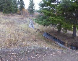
The remains of the flume along the Deadman Valley Road
Photos by Robert Allen
Previously published in The Link magazine, these two articles appear in The Scrivener with gracious permission from Robert Allen. Orchard Irrigation Flume
In September 1985, while driving west from Kamloops toward Cache Creek with my father and one of my uncles, we drove past Walhachin (pronounced Wall’-a-sheen) and my uncle pointed out the remains of the flume on the hillside above the Trans-Canada Highway.
I had probably noticed it before but hadn’t really paid attention. My uncle pointed out that water had been brought down the Deadman Valley, eventually crossing the Thompson River to provide irrigation to the orchard area of Walhachin. A number of gentleman English farmers arrived in the early 20th century with the promises of wonderful soil where apples would grow by the bushelful.
Well, their dream didn’t turn out as they had hoped and when World War I broke out, most of them left to serve their home country and most never returned. The story of Walhachin is an interesting one; if you are interested in reading more, I suggest reading, Walhachin, Birth of a Legend.
I have been back to visit numerous parts of that flume since. Log Flume I read about another flume north east of Johnson Lake and west of Adams Lake. On one of my hunting trips in the area, I had to go look for it. It was
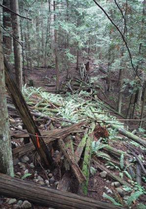
Part of the remains of the old flume

located at N 51o 11.297’ / W 119 o 42.657’. Wet snow had fallen the night before and was dripping off the trees; I got soaking wet while basically stumbling through the swampy ground and bush following my GPS to ground zero. Here is a write-up I read on the Internet about the flume: https://www.geocaching.com/geocache/GC3Y4MB_flumetrail?guid=7c6c8ed9-6c88-47ab-92ce-70097ff11c5c
“In 1918, The Brennan Creek Log Flume was built by the Adams River Lumber Company to transport logs from the high plateau country to Adams Lake. At its peak, over 18,000 logs were on the skidway at any given time. The flume was approximately 6 miles long!
Remains of this flume can still be seen by a heritage hiking trail at Brennan Creek.”
More of the structural remains

I find it hard to believe there is truth to that number of logs. Chainsaws had not been invented at that time so all the trees would have to be felled, trimmed, bucked by hand, then dragged to the flume by horse or oxen. That would require a tremendous number of animals and even more men! While I don’t have any proof the statement is an exaggeration, it was repeated a number of times on various webpages.
It was a very wet and soggy day and the area where the flume started was all grown over; it was hard to get a good photo. I was wet, my camera was wet, and I wasn’t looking forward to the trek back out to the truck. It was described as a short walk along a trail; it was about 800 metres each way, however, and I didn’t find any trail.
A long-abandoned flume on the west side of the Campbell Range Road. Water flowed down the flume toward the road from a small lake about 800 metres to the west.
A continuation of the long-abandoned flume but on the east side of the Campbell Range Road. The water went through a culvert under the road.

The remains of a flume near the Sidewinder Trail

Shake Bolt Flume In 1906, a land-clearing fire on the east side of Roberts Creek on the Sunshine Coast got away from those tending it and burned a good portion of the lower part of Mount Elphinstone. Many many Western Red Cedar trees were killed but not fully burned; they soon became valuable for shakes to be used on roofs of houses.
Various entrepreneurs built flumes on the slopes of Mount Elphinstone for carrying shake bolts down to the ocean; there is still some evidence of the old flumes in different areas. One of the creeks in the Roberts Creek area still bears the name Flume Creek! Ranching Irrigation Flume In my travels, I have seen a number of flumes that have been used for irrigation for watering hay fields. With modern sprinkling systems, a lot of those flumes are no longer used. Most of the small lakes in the interior had dams built on them many years ago to store water for use in the Summer; some of that water flowed down to the ranches and farms through creeks and some went through flumes such as the one into Walhachin and through the one shown below that is near the intersection of the Campbell Range Road and the Robbins Range Road east of Kamloops. It can be found at 50o 34.546’ / 120 o 00.614’.
As I started researching these irrigation flumes, especially the one into Walhachin, various Land Surveyors’ names were mentioned. The flumes had to be constructed such that the water flowed slightly downhill and not too fast, to prevent erosion in the open ditch portions.
Who would be better to determine the location and grades but a British Columbia Land Surveyor? Harold Reginald (Reg) Monroe Christie, BCLS #43, from Ashcroft was one of those Land Surveyors who worked extensively on that project. Christie was not the only Land Surveyor who grew up in Ashcroft; there were five of them but their story will have to wait for another time.
For more information on flumes and irrigation, read Water from the Hills—The Story of Irrigation in the Vernon District. My book review is in the December 2017 issue of The Link. Note: All photos in this article were taken by Robert Allen. s Robert Allen, BCLS (Life Member), CLS (Retired), lives in Sechelt, BC.