69 minute read
WINTER 2022 | BAY NATURE

contents
features 18
Tesla Park: Saved at Last
Bay Nature’s David Loeb first toured the Tesla property, a biodiverse slice of the inner Coast Range threatened by offroad vehicle park expansion, two decades ago. Now he sees a crowning conservation achievement—with caveats—in a new deal to protect Tesla as a state park. By David Loeb
22
California’s Underground Waterways
Buried ancient riverbeds flow underground out of the Sierra Nevada. These “paleo valleys” can store up to 60 times more water than surrounding areas, and they might offer a key solution to drought-stricken California’s water challenges. By Erica Gies
30
At Home with Gray Foxes
Bill Leikam has been embedded among Palo Alto’s gray foxes for more than a decade. His observations reveal a multigenerational saga of fox life, death, and family. By Hannah Hindley
36 » EXPLORE
36 east Bay: quarry camping (sponsored)
The East Bay Regional Park District has opened the first new campground in the East Bay in nearly three decades at a filled-in former quarry. It’s a gateway to Coyote Hills Regional Park and, thanks to its history, a special geologic area. By Daniel Roman
Tens of thousands of sandhill cranes return every winter with the rain to flooded fields and wetlands in the Central Valley. The giant birds forage for abandoned grain or probe the wetlands for seeds and invertebrates, dance in courtship, and blast their iconic trumpeting songs through the cool months before flying away to breed in the summer.
Departments
6 FROM THE FIELD 6 Contributors 7 Comments and Baynature.org highlights 8 Editor’s Letter
10 THIS WINTER 10 Bay Nature Almanac | Colorful Winter 12 Signs of the Season | Long-billed Curlews 13 Ask the Naturalist | Dancing Skunks 14 Annotated Nature | World of Tidepools 17 Nature in the Arts | Apocalypse Not 46 Naturalist’s Notebook | Sugarsticks
41 more outdoors
In the North Bay, find a waterfall at Baltimore Canyon Preserve. On the Peninsula, Cowell Ranch State Beach offers a quiet, sandy stretch with extra interest for geology and fossil buffs. By Kristin Hugo
p. 14 Marisa Agarwal is a community ecologist and marine biologist currently volunteering as a naturalist for Friends of Fitzgerald Marine Reserve. She is passionate about connecting people with nature and sharing information on the natural history of coastal ecosystems in the Bay Area. Find her on iNaturalist (@Marisa_A), Instagram (@photofieldguide), or out exploring local tidepools.
p. 22 Owen Smith is an award-winning illustrator whose clients include the New York Times, Rolling Stone, Simon & Schuster, and the United Nations. He has created 20 covers for the New Yorker and recently illustrated a limited edition of John Steinbeck’s The Grapes of Wrath for Easton Press. Smith has designed mosaic murals and relief sculptures for a New York City subway station and a hospital and a public pool in San Francisco. He regularly shows work in galleries in Los Angeles and New York. Smith lives with his wife and two sons in the San Francisco Bay Area and for the past nine years has been the chair of the illustration program at the California College of the Arts.
p. 12Lia Keener, a fourth-year undergraduate student at UC Berkeley, is interested in environmental biology and science communication. She has written for the Daily Californian and The Leaflet. After graduation, she plans to continue learning, writing, and sharing knowledge about animals and the environment while doing work that contributes to conservation efforts. p. 22 Erica Gies, a journalist and National Geographic Explorer, writes about water, climate change, plants, and critters for Scientific American, the New York Times, Nature, the Atlantic, and others. Her book Water Always Wins: Thriving in an Age of Drought and Deluge tells the story of water and its relationships and discusses how we can deploy “slow water” innovations to improve our own relationship with water, reducing impacts from today’s more intense floods and droughts. Water Always Wins is now available for preorder at SlowWater.world.
p. 18 David Loeb was the co-founder and Executive Director of the Bay Nature Institute and the publisher of Bay Nature magazine. Now retired, he continues to roam the trails and waterways of the Bay Area and points beyond and contributes occasional articles to BayNature.org.
p. 30Hannah Hindley has spent the last decade working as a naturalist and wilderness guide along the West Coast, from the Sea of Cortez to Glacier Bay. She is a recipient of the Thomas Wood Award in Journalism, the New Conrads prize, the Bill Waller Award for Nonfiction, the Waterston Desert Writing Prize, and the Ellen Meloy Desert Writers Award. She writes about small creatures, big landscapes, and the scientists who love them. Find her at HannahHindley.com and follow her @hannah_the_bold.
Other contributors to this issue include Jane Kim (p. 10), Michael Ellis (p. 13), Matthew Harrison Tedford (p. 17), Ben Pease (p. 20), Daniel Roman (p. 36), Kristin Hugo (p. 41), and John Muir Laws (p. 46). Front Cover: Owen Smith used oils to paint a vision of rivers flowing out of the ancient Sierra Nevada, which ultimately created riverbeds that today may help us during drought. OwenSmithArt.com
masthead, vol 22, no 1
winter 2022
executive Director/Publisher Regina Starr Ridley eDitor in chief Victoria Schlesinger Digital eDitor Eric Simons
art Director Susan Scandrett
managing eDitor Alia Salim
assistant eDitor Daniel Roman
eDitorial fellow Kristin Hugo research eDitor Austin Price
coPy eDitor Cynthia Rubin aDvertising Director Tina Bocheff
ProofreaDer Dominik Sklarzyk marketing & outreach Director Beth Slatkin
DeveloPment manager Taylor Crisologo DeveloPment associate Madeline Fahselt
office manager Jenny Stampp information technology manager Laurence Tietz
cofounDers David Loeb, Malcolm Margolin boarD of Directors Wendy Eliot, Catherine Engberg, Tracy Grubbs, Bruce Hartsough (president), Nan Ho, Rebecca Johnson, Pete May, Suzanne Moss, Nooshin Razani, Jonathan Taylor, Anh Phuong Tran volunteers/interns Danya Winterman, Alex Atkinson, Jacqueline Gauthier
Bay Nature is published quarterly by the Bay Nature Institute 1328 6th Street #2, Berkeley, CA 94710 Subscriptions: $70.95/three years; $49.95/two years; $28.95/one year; (888)422-9628, BayNature.org P.O. Box 92408, Long Beach, CA 90809 Advertising: advertising@baynature.org Editorial & Business Office: 1328 6th Street #2, Berkeley, CA 94710 (510)528-8550; (510)528-8117 (fax) baynature@BayNature.org Printed by Commerce Printing (Sacramento, CA) using soy-based inks and alternative energy.
ISSN 1531-5193 No part of this magazine may be reproduced without written permission from Bay Nature and its contributors. © 2021 Bay Nature
this winter on baynature.org
Find timely news, art, ideas, and science on the natural world of Northern California at BayNature.org/first-look.
» California’s Antiquated Beaver Policy
Scientists and conservationists have been increasingly vocal about the ecological benefits of beavers to waterchallenged Western landscapes. But as Carolina Cuellar reports, California state policy still leaves local governments few options when a beaver dam shows up— as one family found out in their Fairfield neighborhood.

» Perspective: Adapting to Atmospheric Rivers
California increasingly relies on water from infrequent atmospheric river storms. As the climate changes, though, atmospheric rivers themselves have changed their character. The state needs to start adapting now to weather the storms of the future, writes climate scientist Katerina Gonzales.
» Behind the Landscape with Tom Killion
For this exclusive portrait of the iconic California artist Tom Killion, Hannah Ricker writes about the way the artist relates to the natural world. Art, Killion says, allows us to “make a picture of the world you want to inhabit.”


» Does Protecting Land Work?
It’s a conservation axiom that protected land works to protect the species within it. Surprisingly, few studies have tested that assumption. Daniel Roman writes that over the last few years a team of scientists from Point Blue Conservation Science has tracked birds in protected and unprotected areas of West Marin to see whether land protection truly succeeds.
miscellaneous
C&F_sidebar-hed will format the Addition headings for this section Next, use the style called “C&F_sideThe story “Raptors Rather than Rodentibar-text” to format the text underneath. cides” published in the fall 2021 issue of Both these styles are in the folder called Bay Nature was produced with support Comments&Feedback. Also, just move the top from the March Conservation Fund. of this column down to wherever you need ~~~ the column to begin.. CorreCtion Letter Hello, I have just finished reading “When You Find a Feather, What Can It Teach You?” by Michael Ellis. I thoroughly enjoyed the read, and was impressed that I could identify all but a few of the feathers! But what I couldn’t do was understand the word pulmologist. As a UCSF bilateral lung transplant recipient, I am very familiar with the word pulmonologist, but not pulmologist as used in the article. Can you help me out?
A happy subscriber, Scout Valentine
Hi Scout, Thanks very much for your email. We reviewed our work … and you’re 100 percent right to be stumped. This error has the special distinction of being a misspelling of a word that doesn’t turn up in any dictionary. It’s a colloquial term, not a technical one, according to the Cornell Lab of Ornithology. Some birders use “plumology” to mean the study of feathers, so by extension a plumologist would be one who studies feathers.
Turns out feathers can teach etymology, among other things.
Thanks again, Victoria
in it for the thrill
on A SundAy Afternoon this fall, paddling head-on into the breeze along Point San Pablo shoreline in Richmond, two friends and I met a harbor seal. It was more than a fleeting encounter; I’ll remember that seal the rest of my life. We had gone as far as Castro Point to peer at the rust-and-saltwater-eaten hull of a sunken boat. Turning around to head back to the harbor, we pushed our paddles into the brown Bay water, like sewing needles piercing liquid fabric over and over again—or that’s how I imagine paddles look from below. And maybe it’s what intrigued the seal.
A silver head popped out of the water behind our boards, at first a little ways off and then just five or six feet. We cooed and called hello. Large eyes examined us. The seal slipped inches then feet underwater, blurring into the turbid Bay before surfacing in front of the boards. It took our full measure, and we cooed some more until the moon face sank from sight.
Or so we thought. Because the seal was right behind us again, diving under one board then another, springing up just ahead. It got close enough that kneeling, not standing, on my paddleboard seemed smart. The game lasted for 25, maybe 30 minutes, until we passed the pier extending from Point Molate. I’ve run across a lot of seals while paddling over the years, but never one so eager to engage.
For most of us, certainly for me, it’s rare to experience individuality in wildlife. Maybe we sense that it’s there, but we almost never have the opportunity to witness the richness of wild animal lives, and we can barely dip our paddles into their mental world. And yet glimpses of it spark our humanity.
Citizen scientist Bill Leikam has incredible stories to tell about the selfhood of the gray foxes he’s been observing daily for a dozen years in the Palo Alto Baylands. A taste of what he’s learned is chronicled in science writer Hannah Hindley’s article “How to Be a Fox.” She also offers insight into the field of ethology, which Stanford neurobiologist Robert Sapolsky describes as the process of “interviewing an animal in its own language … what it’s all about is recognizing that other species out there are functioning in sensory modalities we can’t even guess at.”
Thinking now about that curious seal, surfacing into our airy world as we sloshed into its watery one, who knows what drew it to us—probably nothing like my fanciful visualization of paddles and sewing needles (Humans, so sight oriented!). Hindley’s story pushes me, and maybe you, to consider that if a long face-to-face encounter can feel exceptional, then all we still don’t know about nonhuman life and minds is thrilling.
—Victoria Schlesinger Editor in Chief
p. 13
Some Skunks Dance
p. 18
Tesla Park Saved
p. 22
Deluge During Drought
Life in Winter
… includes a period of quiet and dormancy for some, but it’s when the show—the sights, smells, and sounds—begins for many others.

@This Year's Spotlight: Coast live oak

Mock oyster mushrooms
feeding the masses
It’s true that coast live oaks (Quercus agrifolia) are evergreen, but in fall and winter the trees shed old leaves before new flushes of leaf growth begin in spring. The oval, prickly, noticeably concave leaves collect on the ground in drifts like pale gold coins. Hiding in that leaf litter is a feast of mites, springtails, ants, spiders, whiteflies, and many others that feed towhees, thrashers, juncos, and other ground foragers. Farther down, below the leaf layer, lies a cache of acorns, buried by scrub jays. Most get unearthed and eaten by the birds while other food sources lie dormant during the months of February and March, but a few are left behind and germinate.
off the scent
To identify mock oyster mushrooms (Phyllotopsis nidulans), which grow in groups on rotting hardwoods during Bay Area winter, ask yourself three questions: Are they beautiful and orange? Are they hairy? And do they smell bad? Not just bad, but like dirty socks, rotten cabbage, or a sewer—mushroom hunters can’t come up with enough ways to describe the often really awful odor. P. nidulans gets its orange color from a high content of beta (58 percent) and alpha (29 percent) carotene, compounds the human body turns into vitamin A. Too bad the mushrooms often taste like they smell.
new normal
When it comes to California rainfall, “normal” more accurately means unpredictable swings from wet to dry. Our official “climate normal,” though, is based on averages over 30 years. With 2020 in the books, NOAA now defines “normal” here by what happened from 1991 to 2020 instead of 1981 to 2010. What’s the new normal? Less rain on average, by about three-quarters of an inch per year in downtown San Francisco. This year’s intense early fall rain and subsequent very dry spell didn’t look typical. But by mid-December the rain total just about averaged out to it, which for California … is kind of normal.

Spanish shawl nudibranch

Silk tassel Great horned owl
silk tassel
The wavy-leaf silk tassel (Garrya elliptica) typically passes as an ordinary coastal chaparral shrub. Except for when it doesn’t. Which is in winter after the male shrubs grow their long Rapunzel-ish tresses of cream-colored flowers. The small blooms are threaded together like fancy beads on a necklace that can measure a foot long. For all the winter flair, there’s been little documented about who and what is attracted to these flowers and purple fruits in our region, according to Bart O’Brien, the botanic garden manager in Tilden Regional Park. If you know, tell us.
sea slugs of change
Nudis. That’s short for nudibranchs, the fabulously colored little slugs of the sea. The neon trifecta of the Spanish shawl (Flabellinopsis iodinea) comes from it eating the orange-colored polyps (think coral) of the hydroid Eudendrium ramosum. Their pigment colors the nudibranchs. Look for the Spanish shawl during warm-water years: When winter storms expose the polyps, the Spanish shawl feasts on them, and as the Pacific heats, the slugs increasingly turn up in Bay Area tidepools. “They’re a barometer of changing ocean temperature,” says UC Santa Barbara marine zoologist Jeff Goddard. But given we’re in the cold grip of a La Niña, look for them to the south this year in tidepools around Monterey County.
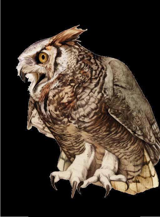
winter tune
When the night is long, black, and cozy with winter, the hands-down best soundtrack is the great horned owl (Bubo virginianus) duet. “Hoo-h’HOO-hoo-hoo,” calls one owl; “hoo-h’HOO-hoo-hoo,” calls the other in response. The female is the contralto to the male’s baritone. These monogamous pairs nest early, at least by February in the Bay Area, says Renée Cormier, an ornithologist with Point Blue Conservation Science. They prefer edge habitats, so you’re likely to hear them in neighborhoods near parks and open space. Listen, and their tune will carry you through to spring.
Catching Up to Curlews
Where our winter shorebirds spend their summers
The long-billed curlew, North America’s largest shorebird, wades through the shallow waters near Bolinas Lagoon in Marin County. As it probes for food, its narrow, arcing bill, at least four times the length of its own head, dips needle-like into the silt and water ahead, and a gentle breeze lifts its speckled, tawny feathers.
Until recently, coastal California’s longbilled curlews, a beloved and relatively common sight along the Shoreline Highway in the fall and winter, posed a mystery for the scientists who study them: where do they go when they’re not here?
Scientists had tracked curlews from their breeding grounds in the American West, Intermountain West, British Columbia, and New Mexico to their wintering grounds in California’s Central and Imperial Valleys, Baja, Texas, and Mexico. But until 2020, the origin of the more than 3,000 curlews that winter annually along the California coast represented “the last piece of the puzzle” for understanding the species’ continental migration pattern, says Autumn-Lynn Harrison, the program manager for the Smithsonian’s Migratory Connectivity Project.
In February 2020, Audubon Canyon Ranch interim Executive Director Nils Warnock, Intermountain Bird Observatory Research Director Jay Carlisle, and other scientists spent a week capturing and tagging two adult curlews, one female and one male, along the shoreline of Limantour Beach in the Point Reyes National Seashore. Now, the data collected from these transmitters is helping to answer the questions that had previously eluded researchers. The curlews left California in April 2020 and found mates in southwestern Idaho, roughly 200 miles apart from one another, Warnock says. In early July, both returned to Bolinas Lagoon for the winter, occasionally venturing back to Limantour Beach. Both took off again in April 2021, bound for their Idaho breeding grounds once more. At this point, the female either died or lost her transmitter, but the male bred and returned to winter again at Bolinas Lagoon, where he still sends back location information every 36 hours thanks to a “ring-box”–size,
A long-billed
curlew walks the sand at Point Reyes National Seashore. solar-powered transmitter safely harnessed to his back.
Curlews wintering in the Central Valley can often be seen “flipping up cow poop” in search of insects, Warnock says, while the curlews of the California coast spend their winters perusing coastal mudflats, unearthing crabs and worms, avoiding predators such as peregrine falcons, molting, and preening. Curlews can spend more than nine months in California, often sleeping in groups at night, then dispersing to feed individually.
Researchers from across North America now compile their data to monitor and track curlews, part of an effort to construct a single range-wide migration map for the species. Understanding the ways that threats on curlew breeding grounds might connect to threats on wintering grounds across country and state borders will also help contribute to what Carlisle calls “full annual cycle conservation.”
“We can maybe pinpoint where conservation efforts are needed,” he says. “We’ve all had our separate projects, but then we’ve found each other and realized, hey, there’s more power with all of our data together.”
Curlews face an uncertain future of limited flood-irrigated habitats in waterstressed states and poaching in recreationally hunted grasslands in parts of Idaho. “Hopefully, in the face of climate change and a growing human population, these [research] efforts can help preserve some of the most important habitats to allow some species to survive with us,” Carlisle says.
Collaborative tracking efforts have helped advance curlew conservation, allowing researchers to better understand where curlews are flying during their seasonal migrations—a major feat, considering that curlews can fly hundreds of miles in a single night and are difficult to tag.
“It’s like when you’re working on a real puzzle, and then you get to a piece that’s really hard,” the Smithsonian’s Harrison says. “That’s when you enlist other people to help you fit in those last pieces, and that’s what we did. We had these tricky pieces that we really needed everyone’s help to figure out.” ◆ —Lia Keener

Why and when do skunks dance?
A: Now that marijuana is legal and much more ubiquitous, I’m never sure whether it’s the car in front of me I’m smelling or a road-killed skunk. Both have potent volatile chemicals that differ but can smell alike to us humans because both contain sulfur compounds.
Our name for the much-maligned skunk comes from Algonquian, a widespread language group common throughout New England. Seganku means the fox (or mammal) that urinates. I’ll say! But urine is innocuous compared to a skunk’s sticky, yellow, penetrating, highly acidic, and unpleasant emission. Contrary to popular myth, you will not go permanently blind if it gets in your eyes. While vomiting you may, however, regret the news that you’ll continue to live. Another bit of folk wisdom says a tomato juice bath removes the smell. However, the ex spurts (get it?) say washing with a mixture of one quart of 3 percent hydrogen peroxide, one-fourth cup baking soda, and one to two teaspoons of dishwashing soap should do the trick. Clothes should be burned.
Humans have greatly altered the American landscape in the last 400 years, and our wholesale clearing has benefited some species of skunks. Skunks are extremely adaptable and can live in the suburbs eating back-porch cat food or in the wild eating beetle grubs and yellow jackets. They amble along investigating everything in their path and digging little holes as they go. Their scat is usually dark brown or black, lightweight, and full of insect exoskeletons.
We have two species of skunk in the Bay Area: the familiar striped skunk (Pepé Le Pew) and the much less common and slightly smaller spotted skunk. Above: Game cameras directed toward the head. The striped skunk is found throughout North America. capture western spotted skunks dancing to warn off predators in Pima The spotted, aka dancing, skunk actually does a There are seven species of spot- County, Arizona, and handstand, spread-eagled, ted skunk, with a similar distri- (below) in Monterey pirouetting like a little balbution that extends into Central County, California. lerina, raising all the hairs America. Our local species is the on its body, and displaywestern spotted skunk (Spilogale gracilis). ing the anus and the formidable spraying
With a well-developed pair of scent glands. If the warned party does not get the glands next to the anus, skunks’ notori- message at this point, too bad. ously formidable spraying defense makes Spraying really is a last defense because them totally unafraid of any animal, and a skunk has a limited amount of odorous rightfully so. While desperate carnivores oil and it takes about a week to replace. occasionally eat skunks, the main killer I have only seen two live spotted skunks (besides automobiles) is the great horned in my life. But with the proliferation of owl. This creature, not surprisingly, lacks a wildlife cameras, we are seeing more and sense of smell. The skunk’s striking bodily more wondrous videos of twirling skunks, design may serve as a tip-off to other ani- including a feisty one threatening a mounmals, but it’s merely a “GOOD EATS” sign tain lion! I’d love to see this dancing in real for the owl. life—but not too close, considering what
The skunks do give adequate warning to that portends. those that approach too closely. But this is Finally, last week while in my local where the two Bay Area skunk species dif- cannabis dispensary, I noticed they had fer dramatically in behavior. The striped a sale on Super Skunk Strain. I bought skunk usually raises its tail, stomps its some on the off chance I could maybe do feet, and growls before actually discharg- a handstand and some pirouettes. I’ll let ing. The shot is accurate to 10 feet and often you know. ◆


The World of Tidepools
In few places do patterns in nature emerge as clearly as in a tidepool. Head to our rocky shoreline during winter low tides and learn to untangle the complex arrangements of life in these incredibly biodiverse habitats.
Anemones can grow off the sides of vertical channels. During low tides they retract their tentacles and fold inward to retain moisture. An anemone’s mouth is at the center of its disc. Tentacles lined with stinging cells surround the disc and capture detached mussels, urchins, and crabs, which are then passed to the mouth. After digestion, the anemone spits out inedible portions of the prey through the same opening. The waterline in the tidepools of the central California coast changes constantly. With two low and two high tides per 24-hour cycle, the intertidal environment is constantly in flux.

Look for giant green anemones (Anthopleura xanthogrammica) in the low and mid intertidal. Giant green anemones are large and generally solitary; identify them by the lack of stripes on their center disc. Sunburst anemones (Anthopleura sola) are distinguished by stripes that radiate from the mouth to the tentacles. When the tide starts to drop, creatures crowd into narrow channels with steep walls, which offer increased water flow (good for stationary filter feeders) and an exit route to deeper water.
Red algae, such as Prionitis lanceolata, commonly grows in the mid and low intertidal. Snails, crabs, and other small invertebrates live on and among its branches.
Black tegula snails (Tegula funebralis) graze in the high and mid intertidal. In deeper water they tend to be replaced by their cousins: brown turban snails. Black tegulas are a popular snack for many creatures, and hermit crabs often make use of empty tegula shells.
Striking bright pink crustose coralline algae often lines the bottom of shallow pools. Tidepool grazers avoid it as it’s made mostly of unpalatable calcium carbonate. Other species in the coralline algae family grow in branches or tufts.
Resisting Apocalyptic Thinking
Observing extinction and survival through animation
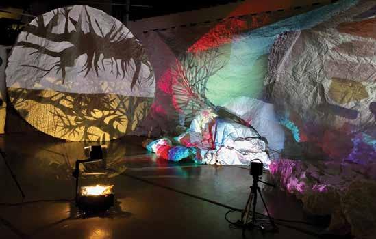
During the 1970 brown pelican breeding season, only one chick out of 552 eggs on California’s Anacapa Island survived. The presence of the insecticide DDT in the marine food web caused brown pelicans, among other bird species, to lay eggs with shells so thin that embryo survival was difficult. By 1978, the California subspecies reached a record low of 466 nests. It seemed at the time like it might be the end for the brown pelican. But it wasn’t. Recent surveys suggest there are around 150,000 California brown pelicans and 650,000 brown pelicans worldwide. Because of environmental regulation, conservation efforts, and strong human advocacy, birds like the brown pelican survived what could have been their apocalypse.
Because of its near-extinction and resurgence, the brown pelican is a main character in The Endless End, an upcoming multimedia installation by Facing West Shadows (FWS) at Institute of Contemporary Art San José. The Alameda-based experimental shadow theater collective wants to encourage audiences to meditate on extinction, survival, and what we can learn from both. Because of successes like the brown pelican, FWS theatrical director Caryl Kientz says she “really eschews the idea that it is the end of the world and the apocalypse.” But at the same time, The Endless End will not offer a watered-down perspective on extinction. “We’re going to have to show some darkness,” adds artistic director Lydia Greer. “I think we’re going to have to go there.”
Though hope and darkness may seem to be contradictory messages for a single artistic project, presenting them raises important questions about how to represent environmental crises. How, for example, can we think about extinction in a way that acknowledges its gravity while avoiding falling into apocalyptic thinking? Can an emphasis on the darkness of ecological collapse help viewers imagine a better future?
The Endless End will be an immersive experience occupying a 750-square-foot gallery space and incorporating stop-motion animation, shadow puppet theater, sculpture, and music. Viewers will enter the installation through a tunnel that grows increasingly dark before they emerge into a large, cavernous room. Animations will swirl around the room, featuring a cast that might include threatened Bay Area species such as the San Joaquin kit fox, tidewater goby, saltwater harvest mouse, and bay checkerspot butterfly, alongside more globally recognizable extinct species such as the passenger pigeon and woolly mammoth.
The design of the installation is in part inspired by proto-cinema technologies and even cave paintings—especially the abstract lines that some scholars believe created a sense of movement when viewed by torchlight. Mock-ups and in-progress animations show an experience that feels primordial and raw. Animations of branches and fungi growing create a sense of vibrancy, but there is also a ghostly feel to the apparitions of extinct or endangered species projected on the cavern walls.
“There’s not a didactic element to it that’s going to tell people what to think and feel,” Kientz says. Nonetheless, in keeping with the circular spirit of the installation’s title, the artists conceived the abstract narrative in terms of cycles, such as darkness and light, past and present, and preservation and survival.
FWS proposes that visitors slow down and observe, but not in a detached or neutral way. Viewers can sit with the experience as it washes over them, and no immediate call to action is required—no comments, reshares, or likes. The artists argue that such contemplative observation leads to more radical ends. Rachel Carson’s Silent Spring, which galvanized action against DDT, was prompted by a letter from a friend who had observed birds dying on her property following insecticide sprayings. The Endless End is an invitation for us to find a place within our political lives for this kind of observation and committed connection to the lands we inhabit.
The current ecological crisis marks the end of many things—species, ways of being, possible futures. But, the artists say, it’s important to acknowledge that as serious as these endings are, they do not add up to the end. There is always a future; darkness and loss are not the same as apocalypse. The brown pelican’s demise never came, because people acted. And so, Greer says, the piece asks us, “How do we survive this?” If we predict we’ll have to give up, Kientz says, “we give up on our ideas and on our imagination.” ◆ — Matthew Harrison Tedford
Tesla Park saved

it was a gorgeous blue-sky, green-hills spring morning when we arrived at our destination in Corral Hollow in eastern Alameda County. We climbed over the closed fence and made our way into a beautiful and serene Inner Coast Range valley lined with cottonwoods and sycamores and surrounded by hills dotted with blue oaks, buckeyes, gray pines, and an abundant array of spring wildflowers.
A few weeks earlier, soon after the publication of the first issue of Bay Nature magazine in 2001, I had received a call from Steve Edwards, then-director of the Regional Parks Botanic Garden, concerning an imminent threat to a biologically significant but little-known open space east of Livermore. It was the first I had heard of Tesla. (Back then, the name “Tesla” conjured up the eccentric late 19th -century inventor Nikola Tesla, not the comparably eccen-
An unusual wild fringed form of California poppy (Eschscholzia californica) grows at Tesla Park. tric Elon Musk and his electric car company.)
Edwards explained that the Off-Highway Motor
Vehicle Recreation (OHMVR) division of California
State Parks had purchased the property and was planning to incorporate it into the nearby Carnegie State Vehicular Recreation Area (CSVRA). This was alarming because of the rich and diverse biological and cultural resources Edwards said were on the property and the likelihood that those would be lost forever if motorized all-terrain vehicles were allowed free rein. He proposed that Bay Nature run an article to highlight the issue and offered to write it himself. I agreed and we set up a time to visit the property with a photographer to document the scenic and biological value of this place. The article, “The Vale of Tesla: Natural Beauty/Human Designs,” appeared in the October–December 2001 issue of the magazine.
Tesla Park saved

At Last
Now, almost exactly 20 years later, it appears that the area known informally as “Tesla Park” has finally been saved, with the signing on September 23 of SB155, the Public Resources Trailer Bill of the 2021–2022 state budget. In section 21 of this bill, the state of California declares that the 3,100 acres of the “Alameda-Tesla Expansion Area … shall not be designated as a state vehicular recreation area.” In return, the state will transfer $29.8 million to the Off-Highway Vehicle Trust Fund, which can be used to develop “properties to expand off-highway vehicle recreation.”
State Senator Steven Glazer (D-Orinda) and Assemblywoman Rebecca Bauer-Kahan (D-San Ramon) were deeply involved in the negotiations over the bill. “This is a
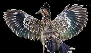
Above: In Corral Hollow, Mediterranean and desert species meet, making the canyon a botanical priority protection area. Below: a greater roadrunner (Geococcyx californianus). win-win for all involved,” a press release from Glazer states. “Our community and region gets to preserve this natural and cultural treasure while the off-road enthusiasts will keep their current park and receive funding to develop another park on land that is more suitable to that kind of recreation.”
This outcome is the result of a battle spanning the past two decades, with organizations such as the Sierra Club, the California Native Plant Society (CNPS), Greenbelt Alliance, Save Mount Diablo, and others banding together with the Friends of Tesla Park (formed by several nearby ranchers and residents in 2011) to oppose expansion of the vehicle recreation area. The environmental groups organized letter-writing drives, filed lawsuits, and brought bills to the
Corral Hollow Pass
private
Tesla
Rd
1600' ) ( Alameda County
to Livermore
Arroyo Seco
Valley Oak-Coast Live Oak Savanna Pen Daren mine tailings
Choke Cherry Scrub
2265' California Annual Grassland MesquitePepper Tree Tree of HeavenPepper Tree Diablan Sage Scrub private
Diablan Sage Scrub
Tesla town site Riparian Scrub and Woodland
Tesla coal mine
Corral Hollow Creek
830'
Tesla Rd Riparian Scrub and Woodland
Blue Oak Savanna CORRAL HOLLOW
private
Blue Oak Woodland
Tesla Park
(future public access)
2064' California Annual
Grassland California Annual Grassland 2113'

Blue Oak Savanna Blue Oak Savanna Blue Oak Woodland Corral Hollow Creek DIABLO RANGE California Annual Grassland
Blue Oak Woodland
MITC H E L L
1120'
Open Riding Area
OHV Trails 1740'
Hetch Hetchy Aqueduct
Diablan Sage Scrub
Blue Oak Woodland
private Stanislaus County
Lawrence Livermore Lab Experimental Test Site Site 300
Corral Hollow Rd
P Main Entrance
Hillclimb Event Area
P
Carnegie State Vehicular Recreation Area
to 580
1600' private
KILN CANYON CARNEGIE RIDGE
CARROL
CANYON
OHV Trails
P P
600'
RAVINE
Diablan Sage Scrub
1400' 2244'
Map 3 Tesla Park and Carnegie SVRA v4, rev 11/16/21 with same OHV trails, service roads, limited historic site info. General brush and trees traced off good NAIP aerial photo Major Plant communities labeled, bolder green, .25 pointi larger. Enlarged 115.8% to match layout.
1000'
Los Vaqueros to Brentwood
Watershed
84 Bethany Byron Rd Forebay
Contra Costa County Old River
Old River San Joaquin River
to Stockton & Yosemite
205
TRACY
to Oakland 580 Altamont Pass
500' LIVERMORE
Stanley Blvd
Isabel Ave Arroyo Rd South Livermore Ave

84
Sycamore Grove Park
SFPUC
V a s c o
R d G r e e n v i l l e R d
Tesla Rd Patterson Pass Rd
) (
Patterson Pass 580
1000'
Corral Hollow Pass
2000' 3000' Alameda Creek 3000'
to Los Angeles
Sunol Regional Wilderness
N
Del Valle Regional Recreation Area Tesla Park Carnegie State Vehicular Recreation Area
Mount Tayor Rose Peak
50' Mines Rd Tesla Rd Corral Hollow Rd Mines Rd
Ohlone Wilderness R e gi o n a l T rai l 0 0
Lake Del Valle Arroyo d el Valle 2 Miles 2 Kilometers
SAN JOAQUIN PLAIN 5 DIABLO R A N G E 132
California Aqueduct Stanislaus County Alameda County
Santa Clara County
to Mount Hamilton and Patterson Merced County
state legislature. Several earlier bills intended to protect Map 1 Tesla Vicinity v4, rev 11/16/21 with 1000 foot elevation shading and contour lines. Tesla had either failed to pass or been vetoed by the govReduced 92.66% to match current layout. ernor at the time. But then a state court decision earlier this year ruled that the state’s environmental impact report for expanding CSVRA was invalid and directed the OHMVR division to start the process over. That appeared
The western
spadefoot (Spea hammondii) typically breeds in rain pools during the winter months; it is listed as vulnerable in California.
N 0
0 1 Mile
1 Kilometer
to open the way for the negotiations that led to the current agreement.
so, then, what has all this fuss been about? Why is Tesla special enough to warrant such a long and bitter battle?
According to Heath Bartosh, senior botanist at Nomad Ecology and member of the CNPS Rare Plant Program Committee, Corral Hollow is significant ecologically because it sits at the junction of the Coast Ranges and the San Joaquin Plain and is the northernmost of a series of east-west-trending valleys running from the Diablo Range into the valley. As such, it is the northern limit for a number of desert-adapted plant, bird, reptile, and amphibian species. Bartosh, who conducted botanical surveys of Tesla in 2015–16, says Corral Hollow is a convergence zone where species that we might expect to find in the Mojave Desert coexist with species more familiar to those of us from the Bay Area. He describes how they probably moved up into the area during a period 8,000 to 5,000 years ago, at the end of the Little Ice Age, and have remained because of the remote nature of the valley. “It’s one of the healthiest and more intact ecosystems in the East Bay,” he says.
Given this combination of rare habitat and proximity to the Bay Area, the Tesla site has been a magnet for studies by Bay Area scientists and their students for many decades. Bruce Baldwin, a professor of Integrative Biolo-
gy at UC Berkeley and director of the Jepson Herbarium, has observed that “the Tesla property harbors an unusual array of vegetation types, including rare assemblages such as desert olive scrubland, and the habitat quality is particularly notable.” Others who have conducted studies at Tesla include renowned UC Berkeley herpetologist Robert Stebbins, who wrote in 1980 that “because of its accessibility and unusual flora and fauna, Corral Hollow is an outstanding wildlife resource area for the people of the Bay Area.”
In 2010, the East Bay chapter of CNPS designated the property a “Botanical Priority Protection Area,” one of 15 in the East Bay. Plant surveys conducted in Corral Hollow found 76 species that are considered locally rare and significant, 35 of which are at the northern limit of their ranges here. Bartosh points out that this is particularly significant in a time of climate change, when organisms at the limit of their range are more likely to be adapted to changing conditions. Moreover, Corral Hollow is also considered an important wildlife habitat corridor, with intact habitat leading from the rugged Diablo Range down into the San Joaquin plain: In 2013, it was classified as a “Critical Linkage Wildlife Habitat Corridor” by the Upland Habitat Goals Project of the Bay Area Open Space Council.
Tesla is notable for its cultural resources as well. It is a village site of significance within the ancestral homelands of the Yokuts and Ohlone peoples and appears to hold several sacred ceremonial sites. It later became the site of the town of Tesla, serving one of the Bay Area’s most important coal-producing areas, where mining helped fuel much of the growth of the Bay Area from the late 1850s until 1915. Some 1,500 people lived here at the mining industry’s height.
Evidence of the former inhabitants of Tesla can be found along and above the valley floor, from the abundant rock mortars in sandstone outcroppings by the creek to the mine tailings farther up the valley, as well as in several level areas on slopes above the creek where buildings once stood. Now, though, nature has mostly reclaimed the place, allowing its surprising diversity of plants and animals to thrive.
An endemic,
rare plant in California, stinkbells (Fritillaria agrestis) are a pretty but smelly lily that begin blooming in March.
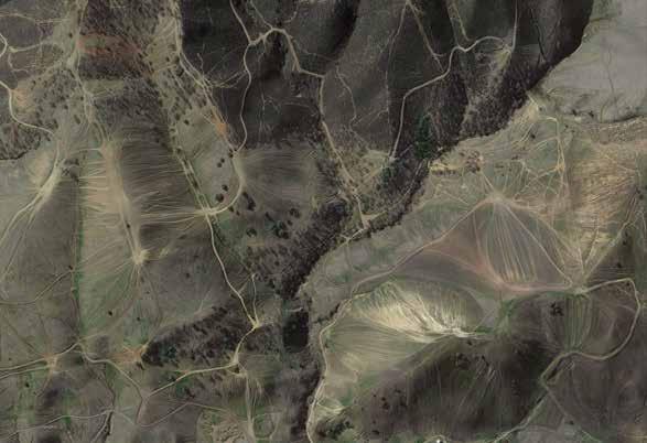
The Carnegie
State Vehicular Recreation Area in Livermore shown from above in a Google Earth satellite image taken in February 2021. that’s why advocates for Tesla Park, such as Beth Wurzburg, who represents the Conservation Committee of East Bay CNPS, are thrilled by the latest developments. “This is fantastic news; we’re delighted that Tesla has been saved,” she says. “Places like this are rare and the opportunities to save them even more so. But Tesla should never have been considered for off-road vehicle recreation in the first place.”
Celeste Garamendi, a rancher in Corral Hollow and one of the founders of Friends of Tesla Park, concurs. “This is a great accomplishment,” she says, “the wonderful result of a collective effort on the part of so many people and organizations over 20 years.” But “now we have to ensure that it receives the highest level of protection in the planning process.”
Both Garamendi and Wurzburg also tempered their elation with further notes of caution. Their first concern relates to the amount of money paid to the OHMVR division for the Tesla property itself. While no one objects to repaying the original purchase price ($9 million), the agreement calls for the payment of some $18.3 million for the property, which OHMVR contends includes appreciation plus money it spent on maintenance and planning. Wurzburg and Garamendi consider this figure highly inflated. Even more controversial is the $11 million included in the agreement for the purchase of land for another OHV park elsewhere. OHMVR is supported by a dedicated stream of vehicle registration fees and gasoline taxes, which makes it the (continued on page 43)
Capturing
Floodsthe
by erica gies

Ancient and buried riverbeds can move and absorb excess stormwater, storing it for future droughts.

Tens of thousands of years ago, California’s Sierra Nevada Mountains wore upon their shoulders the ancestors of today’s rivers. The waterways flowed down from the highlands to meander across the plateau of the Central Valley in languorous braided ribbons. Spurred by sea levels about 400 feet lower than today and climate and glacial processes, the rivers cut valleys 100 feet deep and a mile wide through sediment on the valley floor, as runoff from glacial melt scoured the land, pushing downstream loosened gravel, sand, and silt. Later in the glacial cycle, as sea levels rose and the streams flattened out, they lost momentum. Gravel and sediment dropped out of the water column, backfilling the cut canyons with this coarse material. »
These events repeated themselves over the last million or so years, as glaciers crept down from the north, then retreated. Four of these events have left imprints of their icy ebb and flow below the valley floor. Called paleo valleys, these buried historic riverbeds are still the paths water wants to travel underground, like slow-motion rivers. Their extreme permeability means they can absorb about 60 times more water than the surrounding clay. Aquifers, which are better known, also hold water in coarse soils. But the paleo valleys born of the most recent glaciations are truly special, according to UC Davis professor emeritus of hydrogeology Graham Fogg—the most significant feature underlying the Central Valley. They have super powers for moving water underground because they are exceptionally large, have unusually coarse gravel, and are relatively shallow—perhaps just a meter or two below the surface. Fogg says that every significant stream coming out of the Sierra today should have paleo valleys buried in the plateau. But only three have been discovered so far in California.
Fogg has a long-held dream: to find more of these paleo valleys and use them to replenish groundwater, depleted by our overpumping. When today’s heavier winter storms have filled up reservoirs, we could move the excess stormwaters that would otherwise flood homes and businesses atop these paleo valleys, using them as giant storm drains. The water would be absorbed quickly underground into the paleo valley, then seep more slowly into the surrounding clays. Using the paleo valleys for stormwater management would help to heal the hydrological cycle; it would refill groundwater, raise the water table, make surface flows stronger and healthier, and allow people to continue to pump water from wells.
Fogg calls this strategy to balance water extremes in the age of climate change “a no-brainer.” A mild-mannered man with white hair and glasses, he clearly loves teaching. Groundwater is both an expertise and a passion, reflected in his Tesla’s vanity plate that reads “GRD H20.” Officially retired but still hard at work, advising grad students, reviewing new papers, and conducting research, Fogg can’t let go of the mystery beneath our feet. “My wife thinks I’m incapable of retiring,” he says.
What drives him still is his belief that a better understanding of water’s relationship with buried geology will mean these natural systems can both protect human habitat from flooding and sock away big water reserves to help us survive today’s longer droughts. For decades, as Fogg was putting out the call to find more paleo valleys, few people were listening. But lately, that’s beginning to change.
water security in the underground
California has a long history of swinging between droughts and floods, but climate change is making both cycles more extreme. A thirstier atmosphere evaporates more water out of the soil. And warmer air holds more vapor, so when it rains, it can really pour. Examples include the 2011–17 drought, the atmospheric river storms of winter 2016–17, and the current drought that began in 2020. The state’s rapidly rising population, which has doubled since 1970 to around 40 million today, is also raising the stakes for these water extremes: more people live on land that floods and more people require water during droughts. As the previous drought wore on and meteorologists began to predict winter 2016–17’s torrents, water managers’ thinking started to align with Fogg’s. They wondered: how could they capture the big rains to come, saving water for the next dry spell?
The need to capture winter rains is all the more urgent because climate change is also erasing the Sierra Nevada snowpack, which stores and then supplies 30 percent of the water, on average, that California’s residents consume annually. Climate scientists predict that by 2100, the snowpack could shrink by four-fifths or more. With more precipitation falling as rain rather than snow, water
water underground
Paleo Valley Gravel and sand fill
Aquifer bodies
Silt and clay
Groundwater table

moves down from the mountains faster, increasing winter floods and decreasing summer water supply.
Pumping groundwater has also been a huge source, accounting for up to 60 percent of human supply in drought years. But the last drought showed that practice is unsustainable, as the water table dropped thousands of feet below the surface in places. One silver lining to California’s decades of overpumping is that there’s now a lot of space underground. In the Central Valley, depleted aquifers have unused capacity that is three times that of the state’s 1,400 or more reservoirs. It’s also pretty cheap: storing water underground costs roughly one-fifth the price of building new reservoirs.
While some fear that water moved belowground will be lost, they often ignore the fact that reservoirs “lose” a lot of water to evaporation (which creates rain)—the average annual loss from 721 reservoirs across the United States was nearly equal to the nation’s public water supply in 2010 . Sometimes managers also have to release water from reservoirs ahead of big storms to make space. “Loss” is already part of the status quo. And while it’s true that water underground can travel, that “loss” supports ecosystem health, reducing the need for dedicated river flows to save fish and increasing surface water supplies.
Prior to 2014’s Sustainable Groundwater Management Act (SGMA), California did not regulate groundwater use, a policy failure that gave users the mistaken impression that groundwater was a separate, backup source of water when rivers ran low. But in fact, surface and groundwater are connected via gravity and hydraulic pressure. A full aquifer can push water up through a streambed during the dry season to keep the river flowing. And vice versa: when groundwater levels fall, water in a stream can sink underground to refill the aquifer, leaving less surface flow. Gravity pulls water toward the center of the earth. Then when it reaches certain depths, hydraulic pressure can drive the water upward. This phenomenon feeds springs, perennially flowing creeks, and most wetlands, which would not survive without upward-flowing groundwater. A healthy water table also helps plants to stay hydrated, making them less likely to burn in forest fires. But people began aggressively pumping groundwater in the mid-20th century, so today upward-flowing water is diminished and, in some places, gone, which can mean dry springs, empty creeks, and desiccated wetlands.
Our heavily engineered water management is intensifying problems in other ways. To create California’s agricultural empire, we rush water off the land, depriving it of its natural slow phases in wetlands and floodplains that allowed it to infiltrate deep into the ground. In fact, before we built levees and filled in wetlands, nearly the entire Central Valley would flood most years; some areas remained inundated for six months at a time. Without that natural recharge, pumping depletes groundwater more rapidly.
During the last drought, water managers began to panic as dropping groundwater levels accelerated other problems. Some
places experienced sinking land, or seawater seeping into fresh water supplies along the coast, or wells running dry. These hazards convinced California lawmakers to pass SGMA to regulate groundwater for the first time. As that law is starting to come into effect, local water managers across the state are increasingly considering recharge. Such wide-scale efforts would reclaim land for water’s natural slow phases. It’s part of a worldwide shift in naturebased approaches to resource management that I’ve come to think of as the “slow water movement” while researching my upcoming book Water Always Wins. To recharge groundwater, paleo valleys aren’t required, but they could provide some important options. Recent recharge projects moved back levees and reclaimed “Every major stream parts of floodplains in the state. Others temporarily flooded farms. But agricultural fields coming off the aren’t always ready to recharge when the win Sierra Nevadas has a ter rains come. Sometimes farmers have just applied fertilizer, so flooding the field would shallow paleo valley” move pollution underground, or a crop might be harmed by the water. These challenges have led to Fogg’s excitement about the promise of paleo valleys and their potential to sidestep conflicts with agriculture.
hunt for the wild paleo Valleys
Like many Californians, I had not given a lot of thought to what lies under my feet. If asked, I’d have come up with soil, rock, sand, clay, possibly some pockets of oil, gas, minerals, water. That’s not wrong, but it leaves a lot out. I learn more when I meet up with Graham Fogg northwest of Sacramento on a hot May day so he can show me subtle signs of water’s past on today’s landscape. Fogg made a name for himself in hydrogeology with a landmark 1986 paper, in which he argued that predictability is the key to grokking underground systems. Hydrologists have tended to overlook the structure of the underground because it was thought too chaotic to measure. But the glacial episodes that laid down the paleo valleys mean they have an inherent predictability, making it possible to understand what we can’t see. “That’s how I can say that every major stream coming off the Sierra Nevadas has a shallow paleo valley produced by the last glacial episode,” Fogg explains. The paper also argued that passages between coarser sections create flow paths that water prefers. In the Central Valley, 65 to 80 percent of the underground is silt and clay. Throughout that substrate, imagine the paleo valleys like “the veins and arteries of the groundwater system,” where water really flows, says Fogg. From those arteries, water moves much more slowly into and out of the surrounding clays and silts. Fogg likens the latter to our body tissues. “Most of your body is these soft tissues that water moves in and out of more slowly, by molecular diffusion and other processes.” In this way, water introduced to the paleo valleys would raise the water table closer to the surface across a wide area. Paleo valleys—which scientists also call incised valley fill, or
IVF—were first described by geologists starting in the 1980s. But it would be more than a decade before Fogg’s PhD student Gary Weissmann discovered the first one in California. Today Weissmann is a professor of hydrogeology at the University of New Mexico. Twenty-five years ago, he was studying an area near the Kings River, trying to understand whether a pesticide applied to fields near Fresno had traveled laterally underground to taint local wells. He was in the lab, going through soil cores that people collect when they drill wells to get water, oil, or gas.
Each glacial cycle leaves an identifiable soil layer in the subsurface. As Weissmann worked, he noted the soil strata in his notebook, color-coding the types of sediments along the edge of the paper. Flipping through it, looking for a particular well, he noticed the red marks he’d used to denote ancient soils from the glacial cycle known as Modesto in California, from 18,000 to 10,000 years ago, were all lining up at similar depths. He began plotting sediment types on a map, and the red-marked soils ran in two parallel lines near the towns of Sanger and Del Rey. But between them lay a gap—a different material.
“I thought, ‘That’s kind of weird,’” Weissmann recounts. He looked at additional well logs from inside the gap and saw no red soil marked there, indicating that something had cut it and moved it away. The valley was cut down into older sediment, called Riverbank, from the previous glacial cycle. That’s why he saw no red-labeled soil in the channel between the towns.
“I also saw indications of pretty coarse-grained material like the rubble deposited by glaciers in paleo valleys,” Weissmann says. “I got all excited.” Running into Fogg’s office, “I told him, ‘I think we’ve got a valley here!’” Recalling the moment, Weissmann gushes, “The discovery … was just incredible. I was giddy about it.”
Weissmann’s 1999 publication on the find in the Journal of Hydrology was well received in the scientific community, as were subsequent papers. Fogg thought the discovery’s usefulness for recharge was self-evident. He tells me, “As an academic you think, ‘OK … eventually more and more people will find these things and things will progress.’ Well, it didn’t. It basically sat there.”
Before SGMA passed, groundwater was a property right, and landowners could pump as much as they wanted. Politically, few people were interested in measuring how much groundwater was being pumped out or understanding how water moved underground. Tim Godwin is a hydrogeologist at the California Department of Water Resources who has worked with Fogg on state plans for recharge research. He attributes the lack of curiosity to economics. Mapping paleo valleys was extremely time-consuming, requiring scientists to sift through data for thousands of wells. Or, he says, “you could simply drill a well and get the water you needed.” But today, for many water users, that easy access no longer exists.
Against this backdrop, Weissmann and Fogg continued to spread the gospel through their teaching. In 2005, one of Weiss-
UC Davis professor mann’s grad students, Amy Lansdale Kephemeritus of hydrogeology Graham Fogg says paleo valleys born of art, went through 10,000 well logs and discovered another paleo valley near the city the most recent glaci- of Modesto. She built a 3-D map with the data ations are a prominent and modeled how water would flow through feature underlying the Central Valley. it, showing how useful it could be for water storage. The Modesto paleo valley is about a half-mile to a mile wide and 100 feet deep near the mountains, shortening to 10 feet farther out. She tracked its length for 25 miles and found it could influence groundwater flow—attracting water into it or pushing water out of it—for more than 12 miles on either side of the valley and for hundreds of feet in depth.
A student of Fogg’s, Casey Meirovitz, found a third paleo valley near Sacramento in 2017. Then, in 2019 Fogg’s student Steven
Maples showed that the Sacramento paleo valley could accommodate 60 times more water than surrounding lands. “It’s a shame that we still don’t know where the rest of them are in California,” says Fogg in his mild way. “This should be a priority.”
spreading water
It is finally becoming more important to state water managers.

SGMA’s passage in 2014 at last acknowledged hydrological reality: groundwater and surface water are linked. The law requires people who share a groundwater basin to devise a plan to manage it sustainably by 2040. Those in critically depleted basins were required to submit their plans by 2020. For other basins, the deadline is 2022.
Agriculture accounts for 80 percent of human water use in the state, so the industry is heavily affected by the law and will need to make changes. Bringing a groundwater basin into balance could mean that some farmers shift to less water-intensive crops or take marginal farmland out of operation and return it to wildlife. They could also embrace recharge so they can continue pumping when needed. Godwin, a leader in SGMA implementation at the Department of Water Resources, says that, of the groundwater management plans the department has received, “almost everybody has some aspect of recharge. It’s in at least 90 percent, 95 percent of them.”
Although the sense of water scarcity is often palpable in California, in fact there is enough unmanaged surface water statewide to resupply Central Valley aquifers, according to a 2017 study. The state’s big engineered canals and aqueducts that start up north (where most of the rain falls) and fill irrigation systems in the south are underused in winter when fewer growers need to irrigate, so they could be used to transport excess winter stormwater to depleted aquifers.
Enough water will likely also be available in the future, even with climate change. A 2021 study modeled floodwater quantities for recharge in California under different climate scenarios. The authors found that under a low-emissions trajectory, water available for recharge would increase in 56 percent of the state’s subbasins during the period of 2070–2099. A high-emissions trajectory would see an increase in 80 percent of subbasins. However, infrastructure limitations and policy hurdles must be overcome to make full use of the bounty.
taking to the sky to peer underground
Finding more paleo valleys could help. But with just three discovered over 25 years, water managers need to pick up the pace from monthslong scouring of well logs to more broadly mapping the subsurface. Enter the helicopter. California’s Department of Water Resources (DWR) is investing $12 million from Proposition 68 to map about 100 groundwater subbasins throughout the state using a technology called airborne electromagnetic (AEM) surveys.
In December 2020, a pilot and a technician flew the first survey in a trial run led by Rosemary Knight, a geophysicist at Stanford. They were searching for paleo valleys and other underground architecture over Tulare and Fresno Counties. Hanging from the helicopter was a box about the size of a portable generator. Beneath that, a large hexagram of pipe dangled from ropes, giving the impression of a giant lasso, frozen open. The lasso is a transmitter through which electrical current flows, setting up a primary magnetic field. It generates eddy currents at various depths beneath the ground, and that, in turn, creates a secondary magnetic field measured by a receiver.
After collecting the data, Knight’s team color-coded it. The resulting 3-D image shows sediments with low electrical resistivity, such as clay, in blues, and high resistivity materials, including sand and gravel, in red. Their map covers about 300 square miles and depths up to 1,000 feet. Swirls and pockets of red among the blues reveal where water flows most easily.
Following on from that research, DWR’s partners began running surveys for its three-year comprehensive mapping project in summer 2021. Data will be made available on a rolling basis starting in early 2022, says Katherine Dlubac, AEM project manager for DWR.
Fogg thinks that AEM will be “game-changing” for finding the rest of the paleo valleys in California. Still, the helicopters are flying a “coarse grid,” says Godwin. After creating a rough map of the underground that will hopefully reveal paleo valleys (and other features), people will still need to map detailed information about them, either with higher-density airborne surveys or the old-school way, with data from drilled wells. Godwin says he hopes that local groundwater sustainability agencies will use the initial data from DWR as a starting point for their own. More detailed investigations can ultimately reveal where they can access paleo valleys to move large quantities of water underground quickly, or at least better understand the aquifer system to help them keep water levels in balance through other measures, such as regulating pumping.
Beneath the helicopter dangles a geophysical imaging system used by Stanford researchers to survey belowground for water pathways around Pine Flat Dam near Piedra, California.


This map of geophysical imaging data illustrates ground porosity from the surface to roughly 1,300 feet down. The warm colors represent coarse-grained sand and gravel, while the cool colors represent fine-grained silt and clay. Researchers are looking for pathways of sand and gravel that connect the surface to areas deep below. These pathways could quickly absorb surface water, carrying it away to recharge the groundwater system.
holding space for water
As for Graham Fogg, his decades-long dream of using paleo valleys for recharging water is finally inching closer to reality. But many land use decisions are local, and much work remains to convince decision makers. On our field trip, Fogg shows me the Folsom South Canal, a straight concrete channel filled with water diverted from the American River. It goes largely unused, he tells me, as agriculture has moved on. Just beyond the canal lies an undulating field that rests atop the Sacramento paleo valley. This proximity of underused water to paleo valley makes it a prime spot for a conservation recharge zone—but a large private development is planned for the public land atop the paleo channel.
“I like Graham’s vision,” says Tim Washburn, a senior planner at the Sacramento Area Flood Control Agency, “but it’s very unfortunate that the land use got out ahead of the land use planning. And now we have development that has progressed far enough along that it becomes very hard to stop.” Another barrier, he tells me, is that people in Sacramento are much more concerned with flooding than with water scarcity. Water is typically so plentiful that the local utility didn’t even start measuring people’s consumption until a few years ago. “We don’t have a compelling enough need in the minds of our local leaders” to consider recharge as a better long-term use of this land than the planned development, he says. What local decision makers seem to be overlooking is that the paleo valley could also give them another option for flood control; that’s a significant part of Washburn’s interest.
Godwin says he hopes that SGMA will push water users to look at city and county general plans and begin a dialogue with local land-use authorities. The governor’s water resilience portfolio has also identified this issue. “The AEM data will be really, really helpful at informing some of those conversations,” says Godwin.
In Sacramento, Folsom South Canal is owned by the federal government, which also owns a narrow strip of land alongside. Fogg may have visionary ideas, but he’s also a pragmatist. Injection wells drilled on the federal land could be a compact way to move canal water into the paleo valley. Fogg has talked to Washburn about it, who is working with the Bureau of Reclamation to try to seize this opportunity. “There’s plenty of space to store water,” Fogg says. “You could build the equivalent of another Folsom Lake,” citing the reservoir just up the road that holds nearly a million acre-feet. A demonstration project showing the paleo valley’s speed and capacity could be revelatory.
Fogg remains hopeful, citing the enthusiasm of people such as Godwin and others at DWR to identify paleo valleys for recharge projects. In a 2011 speech accepting an award from the Geological Society of America, he revealed the quiet confidence that has kept him faithful to his vision during the decades in which few seemed to understand or care. “Decide in your head and gut what you think is the right path, and never give up—and of course, never stop listening.” ◆
This article is adapted from Water Always Wins: Thriving in an Age of Drought and Deluge, a book forthcoming in May by Erica Gies pubished by the University of Chicago Press. Learn more at SlowWater.world.
Bill Leikam has spent a dozen years learning in the Palo Alto Baylands. By hAnnAh hindLeyhowto bea fox Photos by Jaymi Heimbuch
the PALo ALto BAyLAndS are roughly three square miles in area, a little corner of relative wildness carved into the deep south end of San Francisco Bay where 15,000 years ago Columbian mammoths and dire wolves roamed a grassy river valley. Within the wetlands, a cement overflow channel fills with floodwater during heavy rains. A water treatment plant hums steadily and a drainage pipe, still wet with raccoon tracks from last night, sieves salt water into the wetlands. But between the channels and pipes, the Baylands are snarled with small trees and tall grasses gone blond with summer heat: perfect habitat for Urocyon cinereoargenteus townsendi, the Townsend’s gray fox.
Gray foxes are elusive but not rare—in the last year alone, citizen scientists logged nearly 350 sightings of foxes on the iNaturalist biodiversity map of the greater Bay Area. Families of foxes have resided on the Facebook headquarters campus since it opened in 2011, gaining a broad online following of enthusiasts. In 2015, a solitary gray fox became a local news celebrity at San Francisco’s Presidio—the first sighting within the park in over a decade. (Around the early 2000s coyotes, which are not above making a snack out of a fox, began making a comeback in the city.) But the Palo Alto Baylands, one of the largest fragments of intact marshland remaining in San Francisco Bay, are the nucleus for what we know about the local lives of these shy animals—in the same way that Tanzania’s Gombe Stream National Park became the geographic heart for the world’s understanding of wild chimpanzees. And just as Gombe had Jane Goodall’s sharp-eyed attention, the Baylands have their own documentarian, too.
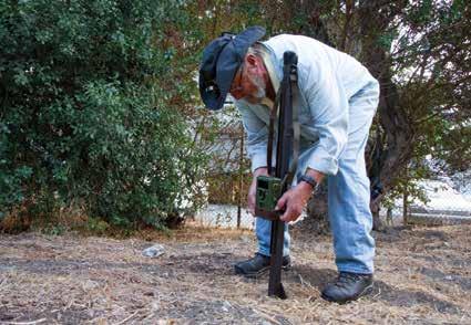
Bill Leikam, “the fox guy,” unlatches the casing for one of his wildlife cameras in the predawn gloom just past the end of Palo Alto’s Embarcadero Road. The smell of the marsh settles around us: bitter willow, pungent eucalyptus. The coffee hasn’t yet hit my bloodstream, but Leikam deftly slides out the memory card and inserts a new one with the spry fingers of someone accustomed to rising early. For 12 years, Leikam—a high school English teacher
kiss
turned trailblazing citizen scientist—has watched the Baylands gray foxes. The foxes, indisputably, have watched him back.
Leikam’s pointing finger throws a heavy shadow across his headlamp beam as he gestures toward the brush at the edge of the path, showing me where, generations ago, he first met Squat, an inquisitive fox that allowed Leikam to linger and watch him go about his daily deeds. Leikam assigns names to the animals he watches: a warmer kind of science than numbers. “Squat,” Leikam tells me, “taught me the basics of being a fox.”
The observations that Leikam makes—dutifully, every day at dawn and dusk—are examples of ethology, the study of animal character. The earliest ethologists—Nikolaas Tinbergen, Konrad Lorenz, Karl von Frisch—were interested in individual variance. Like butterfly collectors, they wanted to catalog the dazzling diversity of animal behavior not as measured in a lab, but as witnessed in the full and complex context of the natural world. When they were jointly awarded the 1973 Nobel Prize in Physiology or Medicine, it was for their work in decoding the information

that animals pass to each other. Ethology, even now, says Robert Sapolsky, neurobiologist at Stanford University, is the process of “interviewing an animal in its own language.”
Every month, Leikam types up his field notes, and they have become a chronicle of family dramas and tender gestures and nightly hunts. Leikam knows where the foxes nap in the crooks of trees, anticipates their shift from syrupy summer fruits to the rich meat of their winter diet, watches their tails sweep from side to side when they are happy, sees where they bury their food and cleanly mark the edges of their territory, listens to them call out to one another in hoarse and raspy voices. The Baylands landscape is pressed deeply with the prints of generations, and Leikam’s reports are enough to fill a textbook. But, much as naming the animals shifts the relationship between scientist and subject, Leikam’s intimate and long-spanning observations shift the focus of natural history from that of understanding species to that of understanding individuals, with interwoven communities and kaleidoscopic nuance. When specific populations are watched with a patient gaze, “generalities come apart,” Leikam says.
Mama Bold took over Baylands territory from her father, Squat, and reared multiple generIt was in 2014, when December was draw- ations of pups with her ing new grass up through the Baylands mate Gray. mud, that Leikam first came to understand how different foxes are from one another. Rain had flooded a low-lying area beneath a tangle of willow branches, and Leikam had sloshed through it on his way to his next field camera. But three foxes—all following him, as the foxes in the Baylands often did for Leikam’s daily rounds—hesitated. Gray foxes do not like water. Leikam watched each fox approach the dilemma independently. A teenage pup splashed through water to catch up with Leikam, but Dark Eyes—the alpha female of the whole region—stuck to the edge of the puddle, avoiding the wettest places. Meanwhile, Cute leaped sideways to a low bough and threaded her way across the flooded area along tree branches, keeping her paws dry. Leikam used to think that foxes were “running on
instinct,” he confides as we scuff across the now-dry puddle, but “they’re as individual as you or me.” They can make choices about how they want to behave, and they can also make choices about the future—Leikam has watched the foxes that often accompany him at a curious distance on his morning rounds take shortcuts in order to meet him at his next wildlife camera site: evidence that they can remember, foresee, strategize, and plan.
The gray foxes of the Baylands, with their bright minds and curious behavior, have shown Leikam
“how to be a fox,” but the rulebook is full of exceptions. Out in the marsh, near the tall eucalyptus west of
Charleston Slough, Little One and Brownie raised two litters together. Their family was the first documented fox family in the area with a “helper”—a lone female, often a grown pup without her own territory, who sticks around to assist in raising another pair’s pups. Since that time, other helpers have been observed, and successful litters have been raised with their assistance. Little One couldn’t have anticipated that Brownie would disappear one day with Helper and never return. He set up a den with his new mate out among the sweet fennel and wild oats in the Emily Renzel Wetlands. For a long time afterward,
Little One would go wandering in that direction, maybe looking for her lost mate, until eventually—perhaps understanding what had come to pass—she crept away. Gray foxes are socially monogamous for life, meaning they stick with their partners and work together until death parts them. Studies have shown that occasionally gray foxes—male and female both—will stray from their territory to mate with other foxes during the breeding season, but Bill Leikam, also they return and care for their young togethknown as “the fox guy,” er, often exhibiting extraordinary tenderand president and CEO ness. Brownie’s divorce from Little One was of the nonprofit Urban Wildlife Research Project, checks his wildlife something different, and in Leikam’s expe rience, unprecedented. camera in the Baylands. The spectrum of fox behavior is not unlike the landscape these animals inhab- Cute, a fox that likes it in the Baylands—well-traveled trails, with a tangly wilderness of possibilities to keep her paws dry, ventured onto the Adobe Creek Loop Trail in the on either side. Alongside the occasional Palo Alto Baylands infidelity, there’s a capacity for deep fam- Nature Preserve. ily bonds. In 2013, among the dry willows on the Matadero Creek floodplain, two siblings learned together how to be foxes, strong and limber. Bright Eyes would leap at her brother Dark Face, who would spin and run toward her. They would skate to a halt, facing each other with bobbing heads, then leap again into the chase. Together, they wrestled beneath the trees and wove through the dead branches like dancers.
When Leikam found a bundle of fur by the side of the road in the early hours of September 1, 2013—a female gray fox knocked lifeless by a car in the night—it took him three days to acknowledge that it was the body of Bright Eyes. During that time, neither of Bright Eyes’ parents emerged from the bushes as usual to greet Leikam on his morning rounds. Her brother would return often to the floodplain near the trees where he and Bright Eyes used to play, looking out across the wide marsh. He limped on his left leg, perhaps clipped by the same deadly car as the siblings bounded together too close to moving traffic. Dark Face moved slowly, heavily, as if weighed down. “They were family,” Leikam wrote of the separated siblings, “in the deep meaning of that word.”
Both gentleness and violence punctuate the lives of gray foxes. A “fox kiss” is a universal gesture: a damp and delicate touch, nose tip to nose tip. Conversely, combat between foxes is ferocious. A fox fight is swift—in the time it takes to draw a deep breath, whole wars are begun and finished. Squat, the presiding Baylands alpha male, first presented his daughter to Leikam when she was still a pup. Squat emerged from the bushes and sat at the edge of the path, glancing behind himself until, a few minutes later, a pudgy little fox materialized. She touched snouts with her father and looked across the path at Leikam—an introduction, of sorts. Bold soon earned her name, appearing alone to daringly watch Leikam


while her siblings stayed hidden in the brush.
But when the time came in 2011for Bold to claim land for a den of her own, rather than dispersing, as is typical, she approached Squat and challenged him for his territory. All teeth and claws, Bold fought and defeated her father in mere seconds, taking possession of the same land where Squat had raised her. In the unruly moment that the fight lasted, Leikam captured a photograph of the violence: Bold airborne, mouth open, her teeth as luminous as a new set of knives. It was the stuff of Greek theater—the ticking of the generational clock, a father’s conquest, the rise of a new empire. It is also the stuff of ethological breakthroughs—behavior like Bold’s is “phenomenally important in understanding social dynamics,” says behavioral ecologist Marc Bekoff, professor emeritus at CU Boulder, who leans forward excitedly as he listens to me relay the story after I return from my adventure with Leikam. “An observation like that could generate 20 theses in a heartbeat.”
After overthrowing her father and claiming her natal territory, Bold became Mama Bold, and together she and her mate Gray reared families of their own—five pups nearly every year, raised on warm milk and the dark meat of woodrats in the brushy neighborhood of Fox Hollow. The pups’ sharp teeth drew blood, so Mama Bold would often lie a few yards from the den. Gray would wander the marsh, returning with food, and he tended to parenting tasks in the den. When the pups were hungry, Gray would approach Mama Bold with a soft nudge, and she would return to feed them. Together, they taught their young how to climb trees, how to hunt. In quiet moments Dark Eyes and Tense touch noses in a universal fox greeting known as between duties, when Gray lounged in the clearing, Mama Bold would snuggle against him and lay her “the fox kiss.” chin across his warm belly. Curled against each other
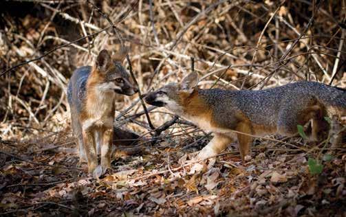
like this, they would nap.
Betrayal, altruism, loyalty, grief. These are recognizable behaviors that reveal not only sharp intelligence, but a nuanced capacity for emotion that eclipses raw instinct. If gray foxes can abandon mates, mourn lost companions, care for young that are not their own, and live long lives in unbroken devotion to one another, perhaps the rulebook needs to be rewritten with attention paid not just to natural history—hierarchies, life spans, diets—but with a deeper consideration for the life of the mind. Leikam has come to understand that these animals lead comGray foxes “hear and plex “emotional and intellectual lives.” He smell their way through the world,” Bill Leikam says, while sight takes a once watched a fox pup as it slept. “All of a sudden, his hind leg went pop, and it was back seat. moving, and that’s a signal that they’re dreaming … I said, ‘What’s going on in that little fox’s mind?’”
It’s a mystery Leikam is still working to unravel. He suspects that foxes might experience their world synesthetically: that is, that they blend their senses and might be able to “smell sound” or “hear odor.” With such keen tools of perception, a fox’s mind might work in ways that science has yet to measure. Leikam has watched, for example, solitary foxes facing a frightening or challenging experience. Other foxes seem to know what’s happening, and will arrive “in times of need from long distances.” What does a fox dream of? What can these animals hear or feel that we cannot?
These questions get at the heart of ethology, a field that has roots not just in muddy-booted natural history but in the study of the mind. Mid-century scientists called behaviorists were frustrated by the “soft science” of psychology, which at the time was a much more introspective, philosophical field than it is today. The behaviorists were keen to make psychology quantitative, to slim behaviors down into universal rules that could be applied across all species. Ethology arose in resistance to this. Where behaviorists sought clean uniformity, ethologists paid attention to variation. Where behaviorists tried to pinpoint rules, ethologists made theirs the study of exceptions. Their questions—then and now—consider individual motivations and individual minds. “What it’s all about,” says Stanford’s Sapolsky, “is recognizing that other species out there are functioning in sensory modalities we can’t even guess at.”
Leikam didn’t think much of it when, in 2016, he started noticing goopy discharge in several foxes’ eyes. He made note of it, but he had witnessed the staggering strength of foxes’ immune systems—their ability to heal swiftly from injured paws and the raw wounds from fights. Yet by the end of the year, 25 Baylands foxes turned up dead—wiped out by a highly contagious viral infection called canine distemper.
Gray. Brownie. Little One. Dark Eyes. Mama Bold. Foxes disappeared entirely from the area—whole families, lost lineages. In their absence, Leikam watched the marsh change. Woodrats, jackrabbits, and field mice exploded in number. The meadows and trails busied with lizards, gopher snakes, gophers, voles, and squirrels—all of which Leikam watched transform the vegetation of the Baylands. He describes gray foxes as keystone predators: animals that, by virtue of their diet, keep whole ecosystems in check. Observations like Leikam’s lay the groundwork for understanding those systemic balances. “You need these data in order to do behavioral ecology,” Bekoff says. The fieldwork, he says, is “foundational.”
For two years and one month, Leikam kept up his daily walks, hoping for a reappearance. Occasionally, video would show up on one of the feeds: a vagabond fox moving through in the night, dark and smooth. But it wasn’t until February of 2019 that foxes finally returned to stay. Now Laimos—Greek for “long neck”— and his mate Big Eyes have taken up residence at Matadero Creek. They have yet to have any pups.
This morning, Laimos approaches us in the dry overflow canal and sits nearby, watching us with glittering eyes. He yawns. Does the future of fox-kind in the Baylands (continued on page 43)