6 minute read
Development grounded in practice. Toward the S-100 standard in sea navigation


by Mona Elo, Researcher, Satakunta University of Applied Sciences (SAMK), Marlene Svegreus, Project Manager, Swedish Maritime Administration, and e-Nav Project Leader, and Antti Värre, Project Manager, SAMK
This article, prepared within the Baltic Sea e-Navigation (e-Nav) project, presents a qualitative overview of the development and piloting of new digital navigation products based on the S-100 standard in the Baltic Sea region (BSR). Anchored in international cooperation and user-centered design, it offers input to the discourse on how harmonized and interoperable data services can support safer, more efficient, and sustainable maritime operations in line with the S-100 implementation roadmap of the International Hydrographic Organization (IHO). Let us then examine the critical steps in ensuring the future-ready infrastructure and the role of cutting-edge navigation products in revolutionizing Baltic Sea maritime operations.
Paper charts for maritime navigation have a long history, though they are young relative to sea maps. The earliest maps are mentioned around the late 11th century, and the earliest ones with sailing instructions for the Baltic Sea surfaced around 1450. Yet, the paper charts form originated in the 1800s, when the British Admiralty published the first official chart.
The conception of electronic charts began in the early 1950s as an article in the Journal of Navigation suggested combining radar imagery with digitalized chart data, which at the time could not be actualized due to the limitations in technology and storage capacity. It was not until the S-57 standard was adopted in 1992 that electronic navigational charts (ENC) became a reality.
Now, with the Interreg Baltic Sea Region-funded e-Nav, we take a step into the future of digital maritime navigation in the BSR by introducing the S-100 standard.
Timely & essential
e-Nav builds on centuries of navigational progress to bring maritime operations into a smarter, safer, and more sustainable digital era. With collaboration across multiple nations bordering the Baltic Sea, the project aims to enhance the way ships and shore-based systems share information, whether for voyage planning, traffic management, or real-time updates. Given that the Baltic is one of the world's busiest and most environmentally sensitive maritime regions, these improvements are both timely and essential.
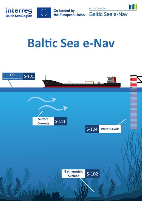
At the core of the project is the development and testing of the next generation of electronic chart products based on the new S-100 standard. These include S-101 ENC, S-102 bathymetric surfaces, S-104 water level data, and S-111 surface current information. Together, they form the foundation of the Baltic Sea Base Package. Harmonization guidelines are also being finalized to ensure these products function seamlessly across borders, with approval set by the Baltic Sea Hydrographic Commission. These outputs will not only improve the efficiency and safety of maritime navigation but also contribute significantly to a more sustainable future in the Baltic Sea.
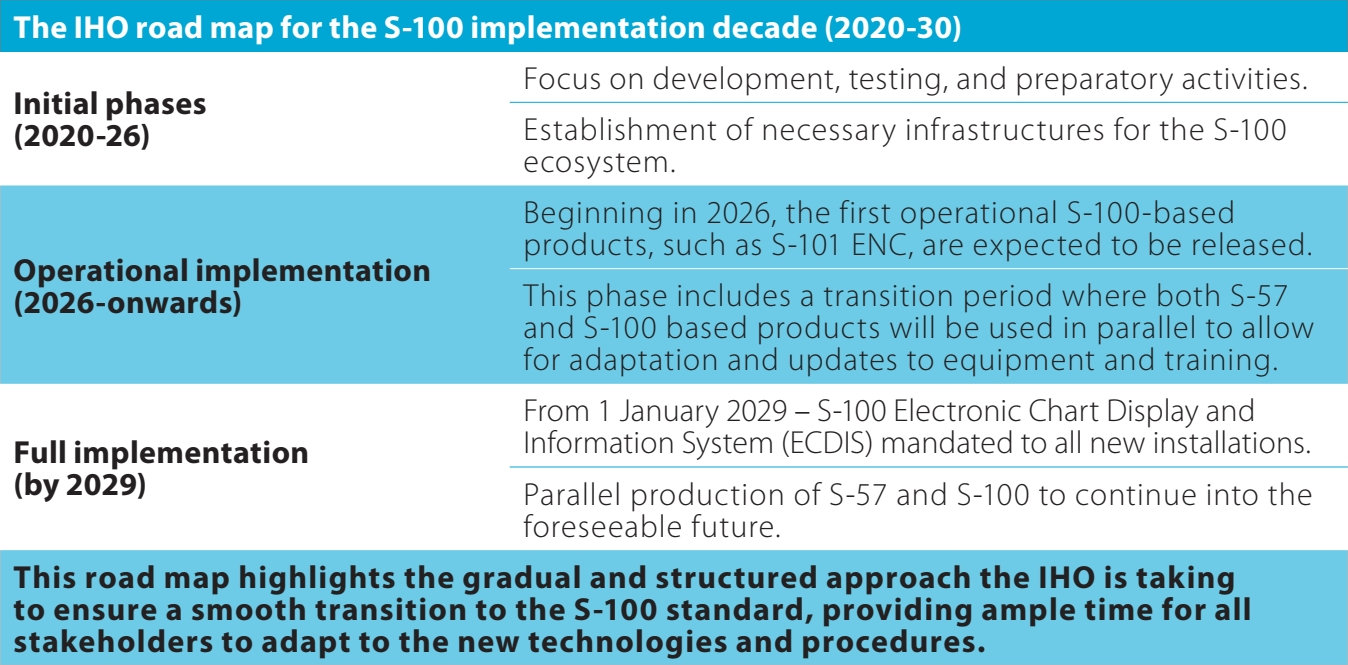
The project promotes interoperability and harmonization across the region, enhancing international maritime cooperation. It also prepares the maritime industry for future regulatory standards, ensuring compliance with the IHO S-100 implementation roadmap by 2030.
Importantly, e-Nav is not developing tools in a vacuum, as close collaboration with end-users ensures new systems are informed by practical needs and on-the-ground experience. Through a series of pilot sessions, navigators interact with early prototypes in simulated conditions, offering feedback that directly informs the design and refinement of S-100 products. By grounding development in real-world use, the project aims to deliver tools that are not just functional but also intuitive and impactful.
A unique testing ground
To understand how these digital innovations perform in practice, the project has established a variety of pilot areas that reflect typical and complex navigational challenges found across the Baltic Sea. These range from high-traffic fairways and shallow archipelagos to open-sea corridors and restricted coastal routes. Each area provides a unique testing ground for assessing how new chart products respond under real conditions.
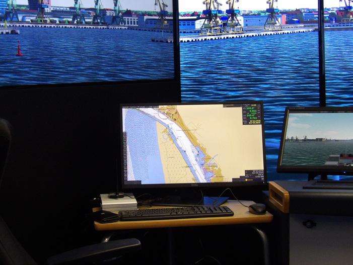
Data collection is methodical and user-focused. Using a combination of structured questionnaires and open-ended feedback forms, information is gathered from navigators before, during, and after simulation exercises. These sessions are conducted in a full mission bridge simulator at SAMK in Finland, allowing for detailed observation of navigational behavior in a realistic setting. The insights gained are passed on to the national hydrographic offices to support the harmonization of S-100 products throughout the BSR.
To enable the effective piloting of S-100 products, the development of a compatible navigation system is essential. Furuno, a leading maritime electronics company, is responsible for designing and integrating the navigation system prototype. Their role includes ensuring the system’s full compatibility with S-100 datasets and providing ongoing technical support throughout the testing and refinement phases.
Early in 2025, the initial prototype was installed in the full mission navigation simulator at SAMK. At this stage, preliminary S-100 products provided by hydrographic offices were loaded into the system, and an expert team conducted the first round of visual inspections to assess rendering quality and data integration.
Tangible improvements
The first testing sessions took place in the early spring of 2025 at SAMK's Rauma campus, guided by project team members from SAMK and the Research Institutes of Sweden. These tests were carried out to evaluate the early versions of the S-101 and S-102 products.
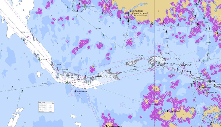
The pilot sessions are designed as immersive workshops, where experienced officers test and evaluate the new data layers within an S-100-compatible chart system prototype. These workshops simulate operational scenarios to explore features like high-resolution bathymetry, dynamic tidal adjustments, and visualizations of surface currents.
Initial feedback from participants points to tangible improvements: better situational awareness, more accurate route planning, and greater confidence when navigating in challenging conditions. The expected outcome is not only increased safety at sea but also reduced environmental impact, which are key goals for the future of maritime navigation in the Baltic.
These products will be used far beyond the project's conclusion (in the fall of next year), as they will serve as the foundation for expanding coverage and data sets in the future. The continuity of the project's output will allow for future developments in digital navigation systems, enhancing the scope and capabilities of maritime operations in the Baltic and beyond.