15 minute read
Giving Curb Visibility to Delivery Drivers
from Intersections + Identities: A Radical Rethinking of Our Transportation Experiences
by APA TPD SoTP
Giving Curb Visibility to Delivery Drivers
Giacomo Dalla Chiara and Anne Goodchild
Advertisement
INTRODUCTION
At the time we are writing this article, hundreds of thousands of delivery vehicles are getting ready to hit the road and travel across U.S. cities to meet the highest peak of demand for e-commerce deliveries during Thanksgiving, Black Friday, and the Christmas holiday season. This mammoth fleet will not only add vehicle miles travelled through urban centers but also increase parking congestion, battling with other vehicles for available curb space.
While the integration of road traffic data with modern navigation systems has seen huge developments in the past decade, drastically changing the way we, and delivery vehicles, navigate through cities, not as much can be said when it comes to parking. The task of finding and securing parking is still left to drivers, and largely unsupported by real-time information or app-based solutions. Delivery vehicle drivers are affected by curb parking congestion even more than any other driver because delivery drivers have to re-park their vehicles not once or twice, but 10, 20, or even more times during a delivery route. Our work, discussed in this article, focuses on improving delivery drivers’ life when it comes to finding available curb space, improving the delivery system, and reducing some of the externalities generated in the process. We first describe what types of parking behaviors delivery drivers adopt when facing a lack of available curb parking, then we will quantify the cost of lack of available parking, estimating how much time delivery drivers spent circling the block and searching for parking. We then discuss how we can improve on that by creating the first curb availability information system – OpenPark.
A DAY IN AN URBAN DELIVERY DRIVER’S LIFE
An urban delivery vehicle is generally considered any van or truck that performs deliveries and pick-ups in an urban area. Typically, a driver starts his journey from a depot, often located outside the city center, and is provided with a list of delivery addresses located across the city – often referred to as delivery manifest. The driver then loads the vehicle and starts the delivery route. The delivery addresses are sometimes ordered in a sequence to reflect priorities, time windows, and such that some objective function, which could be total vehicle miles travelled or total travel time is minimized. More advanced vehicle routing software also takes into consideration road traffic information, routing the vehicle to avoid peak hour traffic.
Unless a delivery location hosts a private loading/unloading bay – a parking area dedicated for the loading/unloading of commercial vehicles – drivers do not park at that address, but rather on the curb, possibly in the vicinity of the destination. Most buildings in urban cores are not even equipped with off-street loading/unloading bays. For instance, in downtown Seattle, only 20 percent of the blocks host at least one off-street loading/unloading bay, with 80 percent of the blocks relying solely on curb spaces (Urban Freight Lab, 2020). Therefore, delivery drivers compete daily with other curb users – private cars, ride-hailing vehicles, public transit vehicles, other commercial vehicles, pedestrians, and bikers – for available space to park and unload the vehicle. Moreover, no available routing software considers curb availability information when generating a manifest, simply because no city in the world actively collects this information. As a consequence, delivery drivers have to use their knowledge of the area and previous experience to decide where to park the vehicle, and for each parking location, how many delivery addresses to walk and deliver to. In a way, parking is an art, and currently, no existing software or routing algorithm can tell you where and how to park.
In part because of that, it is also the most expensive component of the last mile. On average, urban delivery drivers spend 80 percent of their working time outside their vehicles, loading and unloading goods and walking to delivery destinations, while only 20 percent of their time is spent driving between parking locations and to/from the depot (Dalla Chiara et al., 2021). Therefore, if we can use parking information to better route the vehicle to available parking spaces, we might be able to reduce total delivery time and perhaps emissions and delivery costs.
Let’s take a step back, and ask ourselves, what do drivers do when they are not able to find available parking? After performing ride alongs with different carriers, we have identified four types of parking behaviors.
• Double-parking. While it is commonly assumed that urban delivery drivers always choose to double-park, i.e. parking on the travel lane, from empirical data collection (see Dalla Chiara et al., 2021) we observed that double-parking takes place less than 5 percent of the times drivers park. However, this does not mean that drivers always park in the dedicated commercial vehicle load zones (CVLZ). In fact, in our studies, CVLZ parking took place approximately 50 percent of the time. Therefore, while drivers do not always strive to park in curb zones dedicated to commercial vehicles, they still prefer to park on the curb lane (even in curb spaces not designated for commercial vehicles) and not on the travel lane.
• Cruising for parking. When a driver reaches the vicinity of a destination and no curb space is readily available in front of the delivery address, he/ she might choose to circle the block in search of available curb space, which is often referred to as cruising for parking.
• Re-routing. If, after spending some time searching for parking, still no available curb space can be found, a driver might choose to “give up” and drive to the next destination, coming back later in the day. We defined this parking behavior as “re-routing”. Figure 1 shows GPS traces from a vehicle that performed re-routing
• Queueing. Vehicle drivers that are not able to find an available space might choose to temporarily park in an alternative location and wait until the desired space becomes available, hence creating an “invisible” queue of vehicles waiting to access a given space.
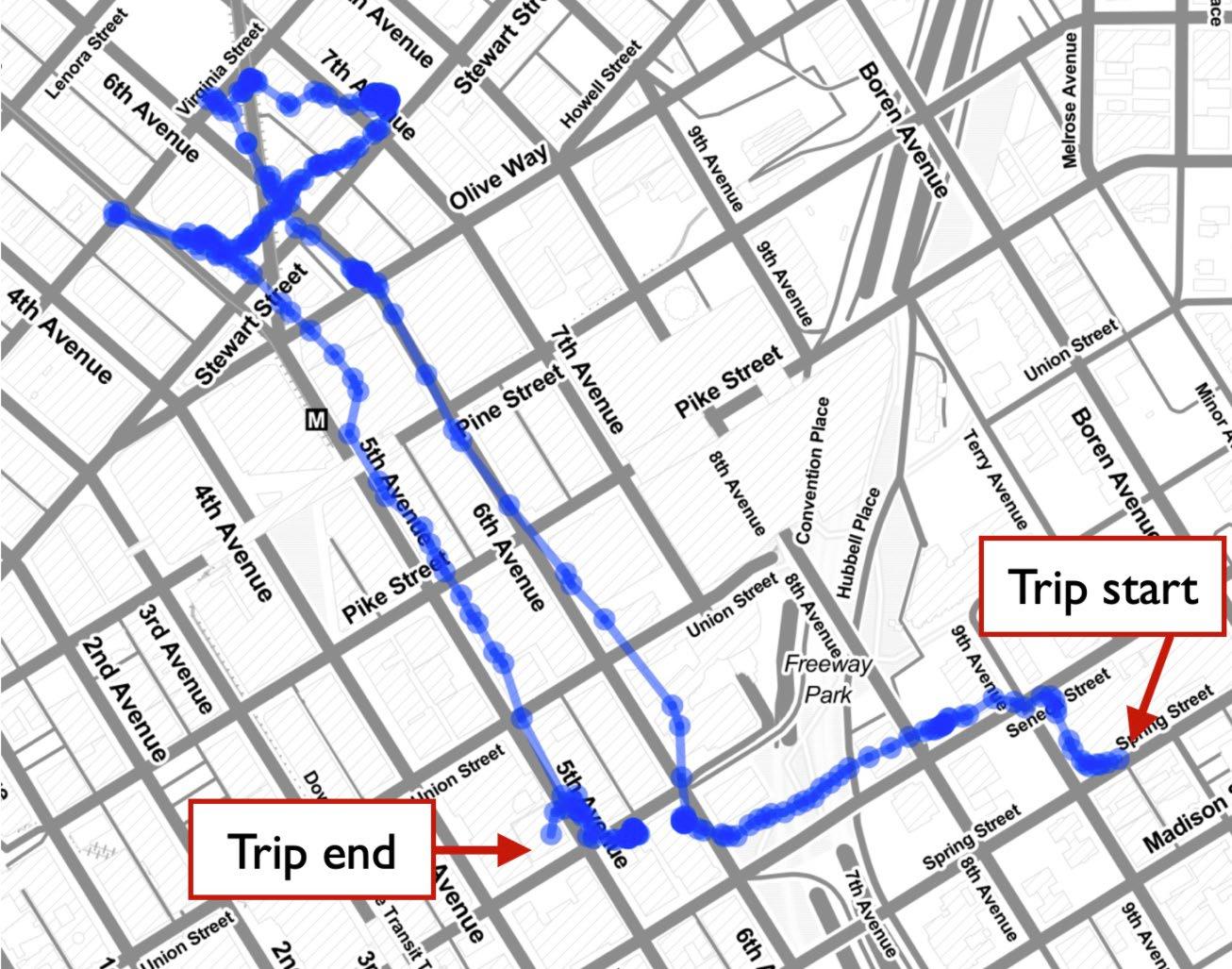
Figure 1: GPS traces from a delivery vehicle that re-routed due to unavailable curb parking
THE COST OF PARKING FOR DELIVERY VEHICLES
What is the cost of a lack of available curb parking for commercial vehicles? Often, the scientific literature points to the number of dollars spent on parking tickets, which for large carriers amounts to millions (e.g. see Kawamura et al., 2014). However, there is another, potentially larger source of cost, which is the time drivers spend searching for parking – the sum of the time spent cruising for parking, re-routing, and queueing.
While identifying the presence of cruising for parking is relatively easy (e.g. through surveys or ride alongs), quantifying it is not. As Donald Shoup wrote, “cruising is invisible” (Shoup, 2006), as cruising vehicles are mixed with other vehicles that are not searching for parking, and even when knowing which vehicle is attempting to park, it is impossible, for each driver, when parking seeking begins.
In a recent paper (Dalla Chiara and Goodchild, 2020), we designed a method to estimate the time that commercial vehicles spent searching for parking. Consider that a delivery vehicle took five minutes to drive from curb space to curb space between two delivery destinations. This time might comprise not only the driving activity but also the time spent searching for parking, circling the block, and visually checking block faces farther away from the desired destination. If the driver would have known in advance the exact location of the nearest available curb space, he/she would have directly routed the vehicle to that space. Let’s say that the time to reach the available curb space directly (without searching for it) is 4 minutes. Therefore, the difference between the original trip time (5 minutes) and the optimal path assuming perfect information (4 minutes) is 1 minute, which we assume is a good estimate of the time spent searching for parking.
We implemented this method using GPS data from two different carriers performing deliveries in Downtown Seattle: carrier A is a parcel delivery company that used delivery vans; carrier B is a heavy-goods delivery carrier that used larger trucks. For each observed vehicle trip time between any two destinations, we subtracted its respective travel time (which assumes knowledge of where available parking is), which we estimated from the Google Maps Distance Matrix API (Google Maps, 2021). We then obtained the empirical distribution of searching for parking times (also referred to as trip time deviations) displayed in Figure 2. The median time spent searching for parking is 2.1 and 3.3 minutes, for carriers A and B respectively. Multiplying each number for the average number of stops per trip performed by each carrier, we obtain that a delivery driver from company A spends on average 50 minutes a day searching for parking, while a delivery driver from carrier B spends 30 minutes a day.
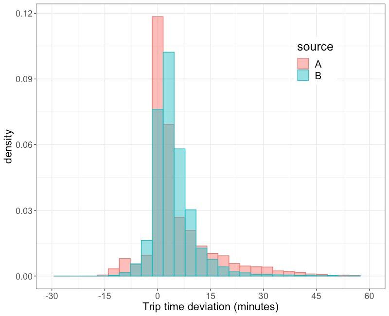
Figure 2: Empirical distribution of time spent searching for parking for delivery vehicles from two delivery carriers: carrier A is a parcel delivery company, carrier B is a heavy-goods delivery company
HARVESTING CURB PARKING AVAILABILITY DATA
Can the delivery driver avoid the 30 minutes to 1 hour per day spent searching for parking if they have curb availability information? To answer that, we first have to find a way to collect curb parking availability information.
When it comes to choosing the best type of sensor to detect vehicle occupancy in curb spaces, many alternative technology options are available. The two main technologies used are video-based and magnetic-based sensors. The latter detects magnetic fields generated by vehicles and is deployed on (or in) the curb, while the first one uses video cameras with image recognition technology, and is deployed on poles or other elevated areas with a clear view of the parking spaces being monitored.
In the implementation described here, magnetic-based sensors were chosen. Each sensor covers a circular area of 10 feet in diameter. Since curb zones can be longer than 10 feet, multiple sensors were installed. The study area consisted of 10 blocks, located in the Belltown neighborhood of Seattle, WA, from 1st to 3rd Avenue and from Battery to Stewart Street. Figure 3 depicts the study area and the location of curb parking availability sensors. A total of 274 sensors were deployed on commercial vehicle load zones (CVLZs) and passenger load zones (PLZs). Figure 4 shows the deployment of sensors on two consecutive PLZ and CVLZ spaces. Each sensor harvests parking availability data and it is triggered every time a vehicle is in the vicinity of the sensor. Each sensor communicates this information in real-time to our servers through gateways, one of which is shown in Figure 5.
Before using the deployed infrastructure, we tested the accuracy of the information received by taking video recordings and comparing real parking events with what the sensors captured. Out of 74 parking events recorded by the videos (hence 74 vehicles observed entering a curb space and leaving after some time) 72 of them were captured by at least one sensor being triggered. Therefore, 97 percent of the real parking events were reflected in the data generated by the sensors, with only two events being missed.
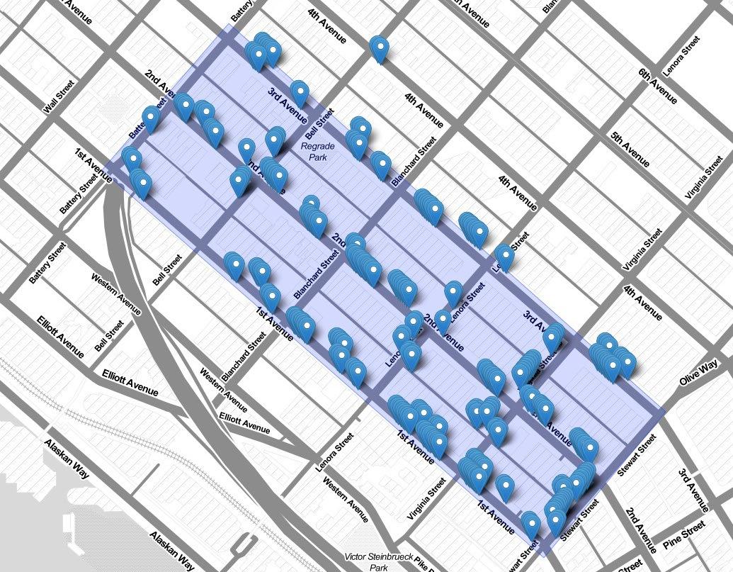
Figure 3: Study area in Seattle, WA, where 274 curb parking availability sensors were installed on commercial vehicle load zones and passenger load zones
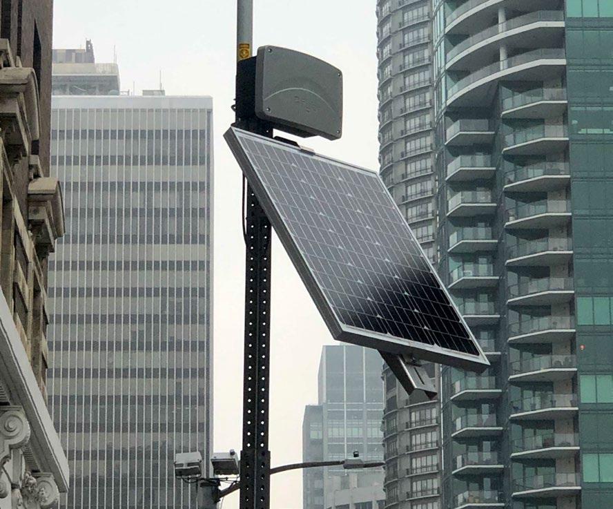
Figure 4: Deployment of curb availability sensors on a passenger load zone and commercial vehicle load zone in Seattle, WA274 curb parking availability sensors were installed on commercial vehicle load zones and passenger load zones
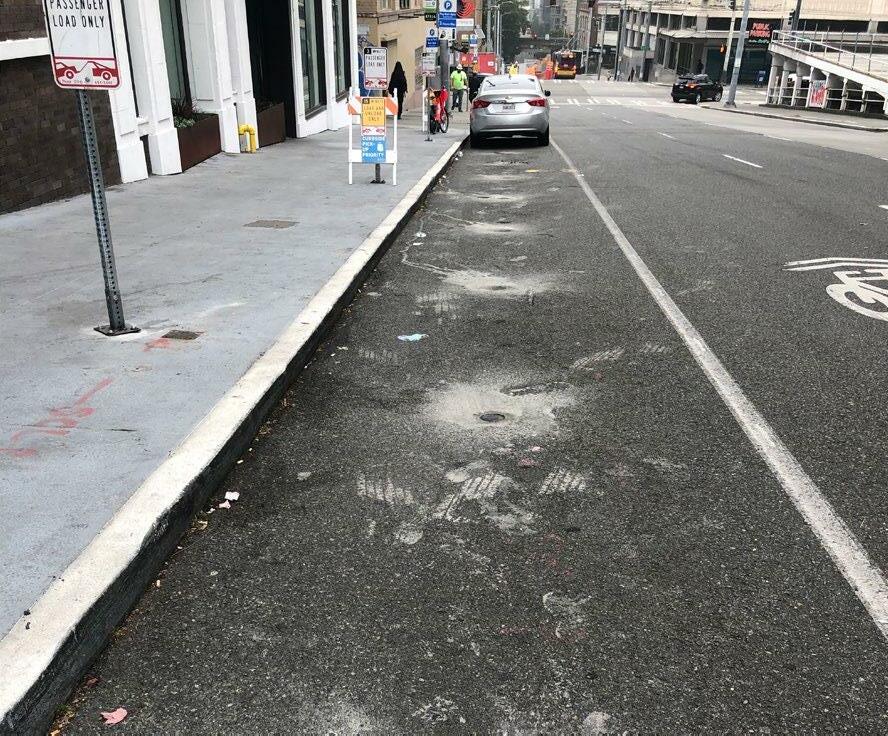
Figure 5: A gateway receiving curb availability information from curb availability sensors and broadcasting this information to the cloud274 curb parking availability sensors were installed on commercial vehicle load zones and passenger load zones
GIVING CURB PARKING VISIBILITY
In collaboration with the Pacific Northwest National Laboratory, we developed an open web application called OpenPark that displays in real-time the curb availability data collected by the sensor infrastructure. A screenshot of the app is shown in Figure 6. Each commercial vehicle load zone and passenger load zone is displayed on a map as a segment, the length of which is proportional to the length of the space. A driver using the app is first asked to select the length of space needed to park the vehicle—longer vehicles clearly will require more curb space. Then the curb spaces hosting active sensors are then colorcoded: green spaces are available right now, red spaces are occupied, and yellow spaces are available but their length is shorter than the specific desired length of curb space.
While the sensors provide real-time information, a driver is usually interested in knowing where available curb spaces are before reaching the destination. Hence, they are interested in a prediction of future curb availability. By storing historical occupancy data for each curb space, we developed machine learning models to estimate curb occupancy 5, 15, and 30 minutes in the future.
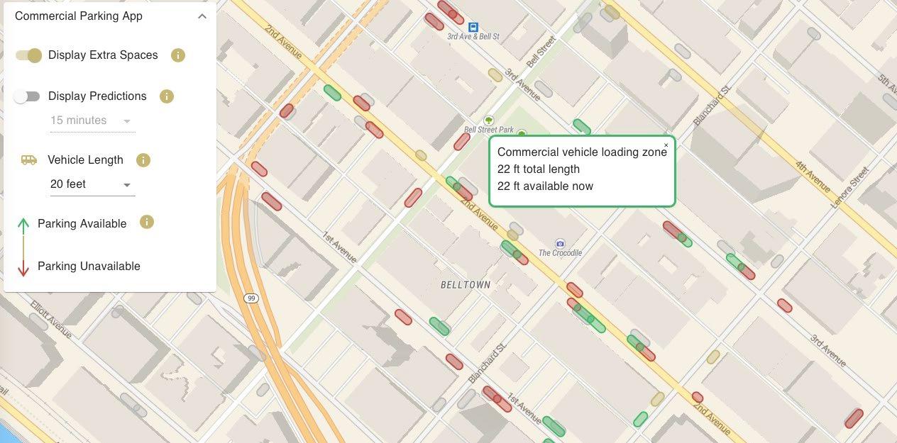
Figure 6: OpenPark web-app displaying real-time and future curb availabilities in the Belltown study area in Seattle, WA
THE FUTURE OF CURB PARKING AVAILABILITY INFORMATION FOR DELIVERY VEHICLES
Once OpenPark was deployed, drivers reported a striking change in behavior in approaching a delivery manifest. Drivers reported that the app allowed them to make better-informed decisions, not only regarding parking but also regarding routing, therefore changing the sequence in which they visit delivery addresses accounting for parking availability. The drivers were able to route their vehicles directly to a specific curb space or block face, while previously the driver would drive near the block where the delivery address is and then search for parking. Drivers were particularly emphatic about the reduced decision-making load, reduced stress levels, and improved sense of confidence and safety with which they were able to go about their work.
Drivers would like to see full integration of curb availability information into existing intelligent transportation systems. In the current study, drivers were not required to provide any information regarding their route, other than the length of curb space they need. In other words, the system is “passive” as it broadcasts curb availability information through OpenPark, but it does not interact with a driver’s route. If more information is available, then a future system could either provide a parking recommendation, hence suggesting the best curb space to park, or even provide a better route, avoiding peak hour parking congestion.
The tools and technologies are available to monitor, provide visibility to, and manage curb space. We are certain that these tools and technologies will continue to be tested and developed, and will be part of curb infrastructure management in the future as these tools provide an opportunity to improve the efficiency of delivery vehicles, reducing their impact on traffic and emissions, and make more space for other users.
About the Authors
Dr. Giacomo Dalla Chiara is a Postdoctoral Scholar at the University of Washington. Previously, he was a research fellow at the Singapore University of Technology and Design in 2018 and a visiting scholar at the Massachusetts Institute of Technology in 2017. He holds a Ph.D. in Engineering Systems Design from the Singapore University of Technology and Design (Singapore) and a M.Sc. in Statistics from ETH Zurich (Switzerland). His research focuses on statistical methods applied to urban mobility problems. In his work, he develops models and simulations to study and develop new sustainable urban logistics practices.
Dr. Anne Goodchild leads the University of Washington’s academic research effort in the area of supply chain, logistics, and freight transportation. She is Professor of Civil and Environmental Engineering, and serves as Founding Director of the Supply Chain Transportation & Logistics online Master’s degree program and the Supply Chain Transportation & Logistics Center, the latter which launched the Urban Freight Lab in 2016 to bring together the public and private sectors to address the challenges of the urban freight system. She has 15 years of experience leading freight transportation research and is an international border and port operations expert.
References
Dalla Chiara, G., Goodchild, A. (2020) Do commercial vehicles cruise for parking? Empirical evidence from Seattle. Transport Policy, 97:26-36, https://doi.org/10.1016/j. tranpol.2020.06.013
Dalla Chiara, G., Krutein, K.F., Ranjbari, A.,Goodchild, A. (2021) Understanding urban commercial vehicle driver behaviors and decision making. Transportation Research Record: Journal of the Transportation Research Board, 1-12, https://doi. org/10.1177/03611981211003575
Google Maps Platform (2019) Distance Matrix API. Retrieved November 1, 2021, from https://developers.google.com/maps/documentation/distance-matrix
Kawamura, K., Sriraj, P., Surat, H., Menninger, M. (2014) Analysis of factors that affect the frequency of truck parking violations in urban areas. Transportation Research Record: Journal of the Transportation Research Board, 2411:20–26, https://doi. org/10.3141/2411-03
Shoup, D. (2006) Cruising for parking. Transport Policy, 13-6:479-486, https://doi. org/10.1016/j.tranpol.2006.05.005
Urban Freight Lab (2020). The Final 50 Feet of the Urban Goods Delivery System: Phase 2, Completing Seattle’s Greater Downtown Inventory of Private Loading/Unloading Infrastructure. University of Washington, Seattle.
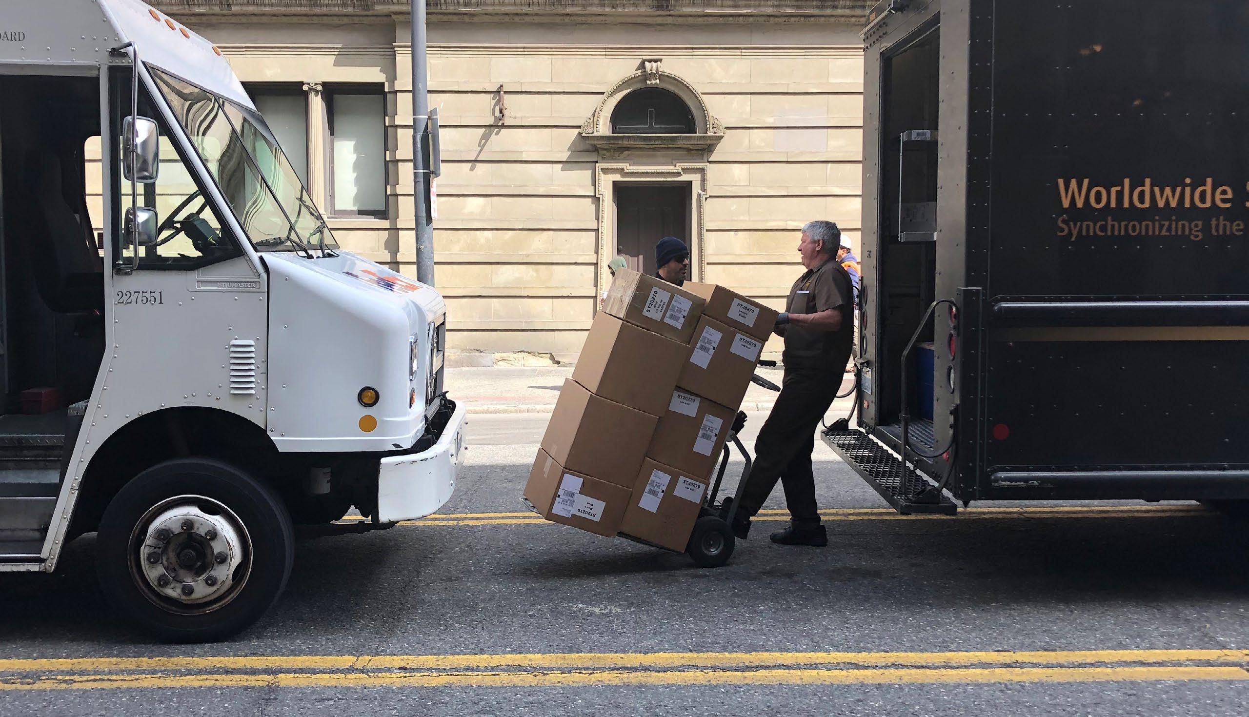
Cover photo: Parcel delivery drivers parking and walking to delivery destinations

