126 minute read
01 PLANNING FOR GOVERNANCE


00.4 MITIGATION
The planning for mitigation section analyzes greenhouse gas (GHG) emissions in urban plans, carbon sinks, urban form and GHG in infrastructure and transportation, urban green spaces and their climate services, neighborhood design and energy savings in buildings, and the development process through the lens of mitigation.
Forests are an extremely important factor for Colombia and its geography, economy and mitigation efforts. About half (52%) of Colombia’s surface is forests, and the nation contains half of the world’s moorlands. Further, deforestation is Colombia’s largest GHG contributor at 16.68%. Taking these two facts into account, it is not surprising that Colombia focuses a lot of its climate change policies on its forests and biodiversity goals. Colombia’s 2020 NDC Update includes over 30 mitigation measures and a goal to reduce GHG The planning for mitigation section analyzes greenhouse gas (GHG) emissions in urban plans, carbon sinks, urban form and GHG in infrastructure and transportation, urban green spaces and their climate services, neighborhood design and energy savings in buildings, and the development process through the lens of mitigation.
Forests are an extremely important factor for Colombia and its geography, economy and mitigation efforts. About half (52%) of Colombia’s surface is forests, and the nation contains half of the world’s moorlands. Further, deforestation is Colombia’s largest GHG contributor at 16.68%. Taking these two facts into account, it is not surprising that Colombia focuses a lot of its climate change policies on its forests and biodiversity goals. Colombia’s 2020 NDC Update includes over 30 mitigation measures and a goal to reduce GHG emissions by 51% by 2030, and to be net-zero by 2050. It is worth noting that this is a significantly larger reduction commitment compared to their iNDC of 2015 which committed a reduction of 20%. This indicates that the policies and their outcomes have been positively impactful enough that the nation felt confident in increasing their reduction goals. Colombia is especially committed to its reductions because they recognize that they are highly vulnerable to the effects of climate change as a diverse geography and economy which are both dependent on the use of natural resources and climatic conditions. Colombia produced an estimated 0.46% of global GHG emissions in 2010, and by 2017 they reported producing 0.25% of global GHG emissions. The Planning for Mitigation section analyzes 22 laws, decrees, plans and policies alongside other literatures to come to an understanding of Colombia’s mitigation needs, efforts, and goals.
The Mitigation Team determined that the climate mitigation strategy in Colombia seeks to address environmental and public health consequences related to global climate change in 5 key areas: consideration of GHG emissions in planning efforts, urban form and physical infrastructure, green space, neighborhood and building design and development approval and mitigation. In regards to GHG emissions assessments, there are several provisions that call for an evaluation of urban form-related emissions, the estimation of carbon sinks and their contribution to overall reductions and climatebased scenario-planning efforts. Colombia also meets the Toolkit’s standards in the way of assessing plans’ abilities to meet mitigation targets across different levels of government and maintains adequate provisions for emission reduction benchmarks.
There are adequate legal provisions promoting a connected, dense, and accessible and urban landscape, with the exception of legislation requiring consideration for existing and planned transportation infrastructure relative to local population and population density. National provisions for greenspace meet toolkit standards in terms of offering environmental and mitigation services through
networks of greenspace. Legislation identifies minimum standards for greenspace and the distribution thereof, though there is limited consideration for networks of greenspace in proximity to existing water bodies. Colombian legislation also requires that neighborhood design principles consider mechanisms for achieving energy savings in buildings, thermal properties of urban spaces, and optimal orientation of buildings in plot design for achieving maximum energy savings.
Colombia also has ample legal provisions regarding enforcement mechanisms for planning and design standards designed to mitigate GHG emissions. These include provisions linking development approval processes to existing urban plans and zoning regulations, allowing for developer fees, and tools and strategies for monitoring the compliance of new development efforts within existing constraints and conditions.
The recommendation is to create additional scenarios to determine the impact and potential of carbon sinks in helping to mitigate climate change. An example of carbon sinks is forests, such as forest reserves or urban forests. Since 2015, Colombia has made a commitment to decrease their GHG output by 51%, and these carbon sinks can help the nation achieve this goal. Creating these various scenarios can assist in balancing the need for green space with capacity, resources, and financial allocation. Colombia tracks the emission of greenhouse gas by type, sector, and per capita, but there are no provisions mandating that emissions from development be tracked on a standardized timeline or the explicit greenhouse gases that should be monitored. Therefore, Colombia would greatly benefit from instituting laws that mandate the assessment of greenhouse gas emissions associated with developments found in urban plans.
Another area of improvement would be to create planning guidelines or requirements requiring the connection of green spaces such as parks and urban forests to blue spaces, like waterways, ponds and rivers. Cities and communities will have a standard to follow when implementing these types of spaces, creating greater regional cohesion and continuity. Greenbelts can be developed to encourage sustainable and proper usage of these spaces, which would increase green areas.
A number of policies aim to regulate neighborhood design principles to achieve energy savings in buildings, though the majority of the policies target active design measures or more generic strategies such as stating a need for “sustainable construction.” An area for improvement is for policies that make provisions similar to those recommended in the toolkit, such as neighborhood plans that consider wind and sun direction when deciding the orientation and layout of the streets; consideration of thermal properties of urban surfaces (specifically recognizing application of thermal properties, such as reducing the urban heat island effect, or a need for high-albedo roof surfaces); and regulation of plot design to achieve optimal orientation of buildings.
The last area of opportunity that Colombia can benefit from would be to create a system where developers of greenhouse gas mitigation initiatives can be held accountable for noncompliance at the time of the development’s approval process. Adding systems in place to keep these developments accountable and to ensure compliance would greatly bolster the rate of green energy development, even possibly closing the loop in the approval process.
Toolkit Subcategory
Urban plans and greenhouse gas emissions
Urban form and reduction of greenhouse gas emissions from transportation and infrastructure
Green spaces for environmental and climate services
Neighborhood design and energy saving in buildings
Development approval and mitigation
Recommendations Actors
Implement a requirement to estimate the carbon sink potential associated with planning scenarios. Close the information gap in measuring carbon pools and sinks and utilize these in developing planning scenarios. Institute laws that mandate the assessment of GHG emissions with urban plans. Integrate GHG emissions as a factor in decisionmaking when analyzing possible urban plans, and possible planning scenarios proposed in the plans. Carbon Sink Potential Estimation:
Environmental Information System for Colombia (SIAC); National Information System on Climate Change, Forest and Carbon Monitoring System (SMBYC); National Forest Inventory (IFN), National Forestry Information System (SNIF); Institute of Hydrology, Meteorology, and Environmental Studies (IDEAM)
Requirement for the Estimation in Scenario Planning:
Ministry of Environment and Sustainable Development; Intersectoral Commission on Climate Change (CICC)
Conduct transit studies to determine appropriate placement of transit infrastructure around population centers; promote community engagement activities to determine transit needs in population centers; create partnerships with adjacent municipalities to establish transit networks. National Information System on Climate Change; National Registry for the Reduction of Greenhouse Gas Emissions (RENARE); Ministry of Environment and Sustainable Development; National Environmental System (SINA)
Assess environmental conditions to determine feasibility of green and blue space connections; analyze health benefits of integrating spaces; conduct environmental impact assessments to determine how the urban form will affect nature areas.
Implement provisions such as neighborhood plans that consider wind and sun direction when deciding the orientation and layout of the streets. In general there should be a focus on adding regulations for a variety of passive design strategies for buildings and neighborhoods. Ministry of Environment and Sustainable Development; Intersectoral Commission on Climate Change (CICC); Municipalities
Enforcement mechanisms would significantly increase the rate of green energy development, even possibly closing the loop in the approval process. Regional Autonomous Corporations, Municipalities, Ministry of Transportation; Regional Autonomous Corporations, Municipalities, Local Parks and Recreational Programs
Ministry of Environment and Sustainable Development; Intersectoral Commission on Climate Change (CICC); Municipalities
00.5 ECONOMIC AND FINANCIAL INSTRUMENTS
Colombia continues to build a very progressive future-focused national climate agenda, including many financing policies supporting mitigation and adaptation efforts. Colombia has taken steps to build a national climate financing system based on intergovernmental coordination and a decentralized power structure. Climate financing in Colombia is driven by public, private, and international actors, with an emphasis on climate mitigation efforts. To summarize the findings in Section 5, Climate financing in Colombia dates back in 1993, when Law 99 of 1993 established the country’s environmental management system SINA. SINA was designed to protect the environment by better coordinating environmental protection work between levels of governments. Law 99 of 1993 created a system of economic instruments to incentivize efficient environmental management, including retribution fees on all sources of air, water or soil pollution, as well as compensatory fees to help maintain renewable resources. Law 1931 of 2018, Climate Change Law, introduced the National Programme of Tradable Emission Quotas for Greenhouse Gases. The program allows for one CO2 ton equivalent unit to be recognized and paid into a national carbon tax offset scheme and links the country’s carbon trading, carbon taxes, and carbon offset schemes.

Law 1931 of 2018 builds upon the National Climate Change System (SISCLIMA), established in 2016, which was designed to coordinate climate change policies, including a system of national-level mitigation actions for each sector under the responsibility of the National Planning Department. In 2018, CONPES 3934 introduced the Country’s green growth policy, which aims to increase financial incentives for green infrastructure. In addition, Law 344 of 1996 established the Environmental Compensation Fund authorized by the Ministry of the Environment, which created a system of transferring national income from the energy sector towards local development. Law 1819 of 2016 establishes a national carbon tax and the legal basis for the National Emissions Trading System (ETS).
In regards to non-sustainable incentives, Law 141 of 1996 created the National Royalty Fund. This fund collects royalties from the natural resource industry, including the fossil fuel industry, in exchange for exploitation of the country’s non-renewable natural resources. The money in the fund is then earmarked for local economic development. The Law has been adjusted many times, but from what we could gather in our analysis, the law appears to continue to incentivize fossil fuel extraction.
The radar graph shows that Colombia’s legislative framework does lack specific information on toolkit item 5.1, resources for urban planning and climate change. This includes lacking specific information on earmarked intergovernmental fiscal transfers for climate financing or information on earmarking local government resources for climate change. Our inclusion of Law 141 of 1996 and its subsequent adjustments have skewed the incentives that prompt unsustainable land uses patterns bullet higher on the graph. Generally, we found many more incentives for sustainable land use than non-sustainable land use.
In summary our legal analysis showed that Colombia is primarily focused on creating financial and economic mechanisms to assist climate change mitigation. These are usually done through incentives, such as tax breaks and direct subsidies for green infrastructure, renewable energy, electric vehicles, and resource management.
Toolkit Subcategory
Resources for urban planning and climate change
Incentives (economic and non-economic) for mitigation and adaptation in urban planning
Incentives (economic and non-economic) that promote unsustainable uses of urban space
Recommendations Actors
Improve coordination and opportunity for fiscal transfer across levels of governments; Provide regional level governments greater ability to lead climate change efforts and allow local government to collect local revenue and engage with their own mitigation and adaptation strategies; Strengthen community engagement
Provide more incentives for the private sector to invest in climate change mitigation and adaptation; Implement increased compensatory fees for activities that harm the environment; Provide financial incentives to practice sustainable cattle ranching projects that can stimulate more intensive, lowcarbon practices. Ministry of Finance, Ministry of Foreign Affairs, Ministry of Environment and Sustainable Development (MADS), Municipalities, DNP, National Council on Climate Change, National Institute of Renewable Natural Resources and Environment (INDERENA), National Development banks, National Environmental System (SINA), The Ministry of Agriculture and Rural Development
Reflect a climate drive agenda in the National Royalty System and note that fiscal transfers for local economic development is not separated from the royalty system for fossil fuel extraction Ministry of Finance and Public Credit (MOFPC), Ministry of Foreign Affairs, Municipalities, National Planning Department (DNP), Regional Autonomous Corporations
National Royalty Commission, MADS
01
GOVERNANCE AND INSTITUTIONAL ARRANGEMENTS
Multi-level institutional coordination
Does your country have provisions in legislation or regulations requiring multi-level institutional coordination for climate action and urban planning?
Do these include legal provisions that require inter-institutional coordination among national and subnational governments?
Do these include legal provisions that require coordination across line ministries at the national level?
Do these include legal provisions that require coordination among local jurisdictions that belong to the same metropolitan area?
Do these include legal provisions that require coordination between neighbouring cities and rural areas that are part of the same economic, social or environmental functional areas?
Do these include legal provisions that require coordination among different line departments in local governments? Participatory Governance
Data Collection and Sharing
Does your country have provisions in legislation or regulations requiring engagement with local stakeholders, civil society and businesses in urban planning processes and climate planning processes?
Does your country have provisions in legislation or regulations requiring data collection and sharing arrangements of climate sensitive information among different institutions dealing with urban planning and climate planning?
Does your country have provisions in legislation or regulations assigning local governments the mandate for urban planning in their urban areas?
Do these include legal provisions that require stakeholder and community identification?
Do these include legal provisions that require participation across the planning process and not only when the urban plans have already been developed?
Do these include legal provisions that require planning institutions to tailor participatory processes to specific community needs?
Do these include legal provisions that require consideration of and response to community demands and priorities?
Do these include legal provisions that grant access to dispute or appeals mechanisms?
Do these include legal provisions that require data collection and sharing among local, subnational and national levels?
Do these include legal provisions that require data collection and sharing among subnational governments (different cities, regions, provinces)?
Do these include legal provisions that require data collection and sharing among different departments and institutions in the same city?
Local governments’ mandate for urban planning in urban areas Do these include provisions with the clear definition of institutional roles and responsibilities?
Do these include provisions that require local governments to build and improve their capacities* to implement their mandates?
Do these include provisions that require or facilitate informal and flexible inter-municipal collaborations, for urban and infrastructure planning, when administrative boundaries do not correspond to functional boundaries and morphological boundaries*?

01 PLANNING FOR GOVERNANCE
The legislation on urban and climate planning in Colombia dates back to the 1990s, starting with the Political Constitution of 19911 and followed by a slate of legislation that regulated the development of territories2 and metropolitan areas3 and set the competencies and requirements for environmental management4 . With the turn of the 21st century, Colombia introduced new laws and regulations on urban planning and land management.5 The recentenactment of climate change legislations6 has been an important step forward. Additionally, the adoption of regulations on disaster risk management7 has been significant in securing Colombia’s environmental future.
The Political Constitution of 1991 and its enabling legislation established a framework for planning and environmental institutions that now coexist with mechanisms enacted through newer climate change law. The Constitution established different functions among institutions and territorial entities related to urban and environmental planning in Colombia and introduced a hierarchical order for their authority: starting with departments, then districts, municipalities, and lastly indigenous territories (article 286). At the same article, the Constitution also provides for the possibility that territorial entity status may be granted to:
• Regions, formed by the association of several departments (articles 306 and 307).
• Provinces, formed by the association of several municipalities or neighboring indigenous territories belonging to the same department (article 321).
Metropolitan areas, which are groups of municipalities united by economic, social and physical relations, do not constitute territorial entities in the strict sense, but may be established as environmental and planning authorities (article 319).
Each entity enjoys a level of political and administrative autonomy that allows it to set and pursue its own territorial interests and facilitates decentralization, according to territorial planning responsibilities, competences and actions aimed at promoting urban development provided for by Law 388 of 1997, known as Ley de Ordenamiento Territorial (the Territorial Development Law) and Law 1454 of 2011, known as Ley
Orgánica of Ordenamiento
Territorial (the Organic Law of Territorial Planning).
1 Political Constitution of Colombia, 1991, https:// www.corteconstitucional.gov. co/inicio/Constitucion%20 politica%20de%20Colombia.pdf
2 Law 388 of 1997, https:// www.funcionpublica.gov.co/ eva/gestornormativo/norma. php?i=339
3 Law 128 of 1994, http:// www.secretariasenado. gov.co/senado/basedoc/ ley_0128_1994.html , repealed by Law 1625 of 2013, https:// www.funcionpublica.gov.co/ eva/gestornormativo/norma. php?i=52972
4 Law 99 of 1993, http:// www.secretariasenado. gov.co/senado/basedoc/ ley_0099_1993.html
5 Law 1454 of 2011, http:// www.secretariasenado. gov.co/senado/basedoc/ ley_1454_2011.html ; Law 1551 of 2012, https:// www.funcionpublica.gov. co/eva/gestornormativo/ norma.php?i=48267 ; Law 1537 of 2012, https:// www.funcionpublica.gov. co/eva/gestornormativo/ norma.php?i=47971 ; Law 1962 of 2019, https://www. funcionpublica.gov.co/eva/ gestornormativo/norma. php?i=96110 , and Decree 1077 of 2015, https://www. funcionpublica.gov.co/eva/ gestornormativo/norma. php?i=77216 .
6 Decree 298 of 2016, https:// www.funcionpublica.gov. co/eva/gestornormativo/ norma.php?i=68173 and Law 1931 of 2018 https://www. minambiente.gov.co/index. php/ley-de-cambio-climatico .
7 Law 1523 of 2012, https:// www.funcionpublica.gov.co/ eva/gestornormativo/norma. php?i=47141 .
8 Law 1523 of 2012, Article 5. The structure of the System is foreseen in Chapter II and its functions in Article 17.
9 Decree 1077 of 2015, Article 1.1.1.1.1.1.
10 Decree 1077 of 2015, Article 2.1.7.1.
11 Decree 1077 of 2015, Article 2.3.2.2.3.3.4.11 for municipalities and districts and Article 2.3.3.2.3.3.4.12 for departments.
12 Decree 1077 of 2015, Article 2.2.3.3.2. It is also worth to mention Law 1523 of 2012 adopting the National Disaster Risk Management Policy and establishing the National
Disaster Risk Management
System8 and the Decree 1077
of 2015 “Housing, City and
Territory Sector”, which regulates the incorporation of risk management in the POTs. This Decree also establishes the objective of the Ministry of Housing, City and Territory,9 that is, to achieve, within the framework of the law and its competencies, to formulate, adopt, direct, coordinate and execute the public policy, plans and projects regarding the territorial and planned urban development of the country, the consolidation of the system of cities, with efficient and sustainable land use patterns, taking into account the conditions of access and financing of housing, and the provision of public drinking water and basic sanitation services. The same Decree also provides for the functions of the Superior Housing Council10 , of municipalities, districts and departments11, and of the entities responsible for public space, which may be created at the initiative of municipalities and districts.12
Since the ratification of the Political Constitution of 1991, Colombia has attempted to formalize land use planning through the forementioned legislation, which builds upon the decentralization strategy of the National Constitution and attempts to build a framework for stronger regional land use planning. Though climate change is not explicitly mentioned, each law can be analyzed through their effectiveness in supporting climate change initiatives. Indeed, urban and regional planning institutions co-exist with environmental and climate bodies and must conform to climate change policies and guidelines.
Though the 1991 Constitution does not specifically mention climate change, it declares the social and ecological functions of property (article 58). The right to property is not absolute and can be restricted for social and ecological reasons; along with the bundle of rights granted to property owners, there are duties and obligations to the community. The Constitution distinguishes between the right to develop property from the right to own property, further enabling the public function of property and the distribution of benefits and burdens in urban development. The two main Constitutional principles regarding property are (1) the social and ecological functions of property and (2) the prevalence of public over private interest. When in conflict, public interest takes precedence over private development interests. Furthermore, the National Constitution states that “it is the duty of the State to protect the diversity and integrity of the environment, to conserve the areas of special ecological importance, and to foster education for the achievement of these ends” (article 79). To this end, according to article 80, the State shall plan the management and use of natural resources to guarantee their sustainable development, conservation, restoration or substitution. In addition, it must prevent and control the factors of environmental deterioration, impose legal sanctions and demand repairs, should damage incur. Likewise, it shall cooperate with other nations in the protection of the ecosystems located in the border areas.
Moreover, three main specific legal instruments related to environmental and climate change management have been enacted and they identify additional institutions in these areas. Law 99 of 1993 (the General Environmental Law) clearly defines at its first article institutional roles and responsibilities as a decentralized and democratic process. With this law, the
Ministry of the Environment
is created as a state entity with the functions of guiding and regulating the design and planning process for the use of the nation’s territory and renewable natural resources, in order to guarantee their adequate exploitation and sustainable development; it also establishes the functions of the territorial entities and environmental planning (Title IX) and configures a system of environmental management, the
“National Environmental
System” (SINA), in which the environmental authority, in ascending order, corresponds to the municipalities or districts, the departments, the Regional Autonomous Corporations and the Ministry of the Environment.
Decree 298 of 2016 establishes at its article 1 the Sistema
Nacional de Cambio Climático (SISCLIMA, National Climate Change
System), which is the set of state, private and non-profit entities, policies, standards, processes, resources, plans, strategies, instruments, mechanisms, as well as information related to climate change, which is applied in an organized manner to manage the mitigation of greenhouse gases and adaptation to climate change in the country. The bodies that coordinate the system are provided for in Article 5: at the national level, the Intersectoral Commission on Climate Change (CICC), which regularly brings together the heads of Colombia’s national executive ministries for the purpose of coordinating climate policy (Article 8); at the regional level, the Regional Climate Change Nodes are responsible for inter-institutional coordination at the regional level to promote, accompany and support the implementation of policies, strategies, plans, programs, projects and actions for both mitigation of greenhouse gas emissions and adaptation to climate change (Article 10).
Law 1931 of 2018, Ley de Cambio Climático (Climate Change Law) establishes guidelines for climate change management through general provisions, identifying the national climate change system and its instruments, tools for climate change management, information systems for climate change, and economic and financial instruments. Notable, this law includes the establishment of the National Council on Climate Change (Article 5), comprehensive climate change management plans, the National Information System on Climate Change, and the
Decree 298 Law 1931 - Climate Change Law Law 99 - General Environmental Law
Global
National
define actions for:
coordination of regional bodies by:
SIAC
Environmental Information System for Colombia
within the framework of:
National Information System on Climate Change
UNFCCC
United Nations Framework Convention on Climate Change
sets commitments for: (including frequency of review + adjustment of master plans)
regulate operation + administration of:
SISCLIMA
National System of Climate Change
defines framework for:
Ministry of Environment and Sustainable Development
coordination + orientation by:
CICC
Intersectoral Commission on Climate Change
permanent consultive body for:
National Council on Climate Change
establish requirements + report annually for: established + organized:
National Planning Department
establish guidelines for: establish guidelines for: establish guidelines for: establish guidelines for:
instruments for:
RENARE National Registry for the Reduction of Greenhouse Gas Emissions
instruments for: instruments for: instruments for:
SNIF National Forestry Information System
IFN National Forest Inventory
SMBYC
Forest and Carbon Monitoring System
PNCTE
National Program of Tradable Quotas for the Emission of Greenhouse Gases
SINA National Environmental System
Sub-National
Regional Node of the Amazon
North Pacific Regional Node
Regional Node of the Orinoco
South Pacific Regional Node Regional Climate Change Nodes
Central Eastern Andean Regional Node
Caribbean and Insular Regional Node
Regional Node Norandino
Antioquia Regional Node manage + coordinate:
Regional Node Eje Cafetero
+ Others to be formed manage + coordinate: manage + coordinate: manage + coordinate:
under coordination, guidelines and directions of:
Institutional
IDEAM Institute of Hydrology, Meteorology, and Environmental Studies
FIGURE 1 Mapping Key Actors of Environmental Laws in Colombia
PIGCCS
Comprehensive Sectoral Climate Change Management Plans
PIGCCT
Comprehensive Territorial Climate Change Management Plans
establishes guidelines for: consult: consult: consult:
Municipalities Districts Public/Private Entities
Regional Autonomous Corporations
Integrated by:
1. The Minister of Environment and Sustainable Development or their delegate
2. The Minister of the Interior or their delegate
3. The Minister of Finance or their delegate
4. The Minister of Agriculture and Rural Development or their delegate
5. The Minister of Mines and Energy or their delegate
6. The Minister of Transport or their delegate
7. The Minister of Foreign Affairs or their delegate
8. The Director of the National Planning Department or their delegate
Members elected for four-year terms:
Two union representatives
Two representatives of non-governmental organizations working on climate change issues
Two representatives of the academy
A representative of the international organizations of support and cooperation to the development
A representative of the fifth committee of the Senate of the Republic
A representative of the Fifth Committee of the House of Representatives
13 Law 1454 of 2011, Article 4.
National Program of Tradable Quotas for the Emission of
Greenhouse Gases (PNCTE).
Together these laws enable, establish, and oversee a series of actors in Colombia working with global, national, subnational, and institutional actors as mapped in Figure 1. matters of decentralization and land use planning. Other functions are determined in Article 6. Moreover, article 8 provides for the power of the Departmental Assemblies and Municipal Councils to establish Regional Land Use
and Zoning Commissions
(departmental or municipal), whose functions will be established directly by the COT. Finally, the law decides that the Technical Secretariat of the aforementioned COT will form a special interinstitutional committee made up of the competent national entities in order to provide the logistical, technical and specialized support required by the COT for the full development of its functions (Article 7).
This law also foresees mechanisms for coordinated action between departments, metropolitan areas, municipalities and districts. In particular, it promotes the creation of territorial associative schemes (Chapter II), such as administrative and planning regions, planning and management regions, associations of departments, metropolitan areas, associations of special districts, administrative and planning provinces, and associations of municipalities.14 The associations of territorial entities will be freely formed by two or more territorial entities to jointly provide public services, administrative functions of their own or assigned to the territorial entity by the national level, execute works of common interest or fulfill planning functions, as well as to procure the integral development of their territories.15 In particular, article 14 states that “two or more municipalities of the same department or of several departments, may associate administratively and politically to jointly organize the provision of public services.”16. The possibility that two or more municipalities may associate, independently of their administrative boundaries, to fulfill urban planning functions, expands the mandate of local governments in this matter, since they may exercise their planning functions in spite of municipal spatial limits and thus pursue a more effective planning that takes into account the needs of the territory.
Law 388 of 1997 also contains language to encourage multi-level government participation though such engagement is not always explicitly mandated. For example, municipalities and districts are supposed to work together to create territorial action plans.17 The national government can also set standards as to how municipalities are to conduct themselves based on their population sizes.18
More explicitly, the Territorial Development Law provides an example of metropolitan interjurisdictional coordination, requiring municipalities within the same metropolitan area to coordinate their work under the larger Metropolitan Board that they are a part of to ensure that the implementation of their strategies is in harmony with the broader goals of the Board.19 The Regime for Metropolitan Areas (Law 1625 of 2013, repealing Law 128 of 1994) further supports the Territorial Development Law by regulating municipalities to coordinate
01.1 URBAN PLANS AND GREENHOUSE GAS EMISSIONS
Colombian decentralization process, which started with the Political Constitution of 1991, is based on a strong regional coordination. According to article 288 of the Political Constitution, the powers attributed to the different territorial levels by the organic law of territorial organization will be exercised in accordance with the principles of
coordination, concurrence
and subsidiarity under the terms established by law.
As a mechanism for vertical inter-institutional coordination, the Constitution establishes the National Planning Council, a consultative body, part of the National Planning System, created to discuss the National Development Plan among the national government and representatives of the territorial entities and of the economic, social, ecological, community, and cultural sectors (Articles 340 and 341). This Council is the embodiment of inter-institutional coordination among national and subnational governments.
Law 1454 of 2011 (the Organic Law of Territorial Planning) also establishes that the Nation and the territorial entities must exercise their competences in an articulated, coherent and harmonious manner (Article 27). At the time of determining the competences assigned to the Nation (paragraph 1, Article 29), the law provides that these shall be carried out in coordination with the territorial entities. In addition, in paragraph 1 of Article 29, the law establishes that the distribution of competencies contemplated in this article will be carried out under the principles of decentralization, concurrence and complementarity of the actions established by the territorial entities and in coordination with the provisions of their respective authorities in the local and regional planning instruments.
For these purposes, Law 1454 of 2011 establishes the Land Use Planning Commission (Comisión de Ordenamiento Territorial, COT), whose function is to “promote integration” between departments, districts, and municipalities,13 thus pursuing vertical coordination, and acts as an advisory body to the National Government and Congress in
14 Law 1454 of 2011, Articles from 9 to 16.
15 Law 1454 of 2011, Article 11.
16 Law 1454 of 2011, Article 14.
17 Law 388 of 1997, Article 12.
18 Law 388 of 1997, Article 91, Paragraph 1.
19 Law 388 of 1997, Article 24.
20 Law 1625 of 2013, Article 2.
21 Law 1625 of 2013, Articles 6, 7.
22 Law 1625 of 2013, Article 8, Part G.
23 Law 1454 of 2011, Article 15.
24 Law 1625 of 2013, Article 34.
25 Law 1625 of 2013, Article 1. through the Metropolitan Board. This law indicates that the formation of metropolitan areas requires the coordination of “two or more municipalities integrated around a core municipality, linked together by dynamics and territorial, environmental, economic, social, demographic, cultural and technological interrelationships,”20 which can also include municipalities within departments or from multiple departments. The Regime for Metropolitan Areas also enables joint coordination of municipalities and associations for public services, as well as for regional transportation infrastructure.21 Additionally, during formation, the initiating municipalities coordinate with the national government to appropriately establish the metropolitan area, and “the promoters shall submit the project to the Special Commission for the Follow-up of the Decentralization and Territorial Planning Process of the Senate of the Republic and the House of Representatives.”22 It also establishes the subsequent governing and advisory bodies, Metropolitan Boards and Metropolitan Councils. Metropolitan area management obligations are also provisioned and include fiscal, social, and environmental duties for territory within the area, with coordination with neighboring Colombian jurisdictions, and with consideration of adjacent international territory. Finally, in accordance with the provisions of Law 1454 of 201123, two or more Metropolitan Areas of the same department or of several departments may associate to jointly organize the provision of public services, the execution of regional works and the fulfilment of their own administrative functions24 .
As a result of law’s intent to decentralize, further compliance of national regulations is not conducted via direct coordination, but in alignment of the
National Development Plan - Departamento Nacional
de Planeación (DNP), the Political Constitution of 1991, and other applicable statutes and laws for National Social Interests, transportation, and the environment. Law 1625 of 2013 also dictates “organic norms to provide the metropolitan areas with a political, administrative and fiscal regime, which within the autonomy recognized by the National Constitution and the law, serves as a management instrument to comply with their functions.”25 This further supports the metropolitan areas provisions in the Organic Law of Territorial
Planning, Law of Territorial
Development, and Law 1469 of 2011, and strengthens regional authority to strategize, resource, and implement territorial plans.
Regarding coordination between rural and urban areas, Law 388 of 1997 mandates coordination between municipalities and the rural areas they oversee on a broad level: Article 12 of this law establishes that the general content of the POT (Plan de Ordenamiento Territorial) should include “the urban-rural structure” to be achieved in the long-term (para. 2) and the communication systems between urban and rural areas and their articulation with the respective regional systems (para. 2.1); consequently, article 14 defines the “rural component of the POT” as a tool to guarantee the adequate interaction between rural settlements and the municipal capital, the appropriate use of rural land and public actions aimed at providing infrastructure and basic facilities for the service of rural dwellers. The same article provides for the content of this rural component in a list of seven points. Article 2 of Law 1454 of 2011 describes the “relationship between rural and urban ways of life” as an important element of land use planning, but the measure lacks specificity and does not require coordination between neighboring cities and rural areas. The Regime for Metropolitan Areas specifies that the Comprehensive Metropolitan Development Plan includes “the determination of the urban-rural structure for medium- and long-term horizons”26 and the Strategic Metropolitan Plan of Territorial Planning must plan rural and suburban land. Some specific agencies and councils have been created to coordinate activities to be realized in rural areas: Decree 2363 of 2015 creates the National Land Agency, in charge of the policy of social ordering of rural property, and the Agency for Territorial Renewal, which coordinates the intervention of national and territorial entities in rural areas, executing projects for the territorial renewal of these areas; the same Decree also creates the Superior Council for Rural Land Management, in charge of formulating general policy guidelines, and coordinating and articulating the implementation of public policies on rural land management. However, the identified provisions should be integrated and accompanied by additional legislation identifying specific mechanisms and structures for urban-rural coordination to take place effectively beyond administrative boundaries, when rural areas are part of the same economic, social or environmental functional areas even if within the boundaries of two or more local government authorities.
On the environmental and climate sectors, Law 99 of 1993 (General Environmental Law) requires that Colombia’s environmental management be a coordinated task between the department, local community, non-governmental organizations, and the private sector27 and emphasizes the importance of multi-institutional governance at the national and subnational level. Article 63 establishes that the exercise of environmental functions by the territorial entities shall be subject, among others, to the principle of regional harmony to ensure the collective interest of a healthy and adequately protected environment and to guarantee the harmonious management and integrity of the Nation’s natural heritage. According to this principle, the Departments, Districts, Municipalities, Indigenous Territories, as well as the regions and provinces to which the law gives the character of territorial entities, shall exercise their constitutional and legal functions related to the environment and renewable natural resources, in a coordinated and harmonious
26 Law 1625 of 2013, Article 13, Part D.
27 Law 99 of 1993, Article 1.
28 Law 99 of 1993, Article 5.
29 Law 99 of 1993, Article 2.
30 Law 99 of 1993, Article 13.
31 Law 99 of 1993, Article 7.
32 Law 99 of 1993, Article 23.
33 Law 99 of 1993, Article 31, Paragraph 4. manner, subject to the superior norms and the guidelines of the
National Environmental
Policy, in order to guarantee a unified, rational and coherent management of natural resources.
The law establishes the Ministry of the Environment (currently: Ministry of Environment and Sustainable Development, MADS) which is responsible for establishing the environmental criteria to be incorporated in the formulation of sectoral policies and in the planning processes of other ministries and entities, after consultation with these bodies28; the MADS is also responsible for coordinating the
National Environmental System (Sistema Nacional
Ambiental, SINA), that ensures the “adoption and execution of the policies and the respective plans, programs and projects”29 and advances decentralized planning, coordination, and implementation while providing opportunities for all stakeholders and levels of government to work towards sustainable development and conservation.
To ensure intersectoral coordination at the public level of environmental and renewable natural resources policies, plans and programs, Law 99 of 1993 created the National
Environmental Council (Consejo Nacional Ambiental,
CNA) which includes members from the national level (ministers) and members from the territorial level (a representative of the governors, a mayor representing the Colombian Federation of Municipalities, etc.), as well as members of private organizations whose functions affect or may affect the environment and renewable natural resources.30 The National Environmental Council will create councils at the level of the different territorial entities so that different local sectors can participate and collaborate in environmental management. However, it is important to note that it is essentially a function of the department to regulate and guide environmental management and sustainable development in their respective territories.31
One critical example of public entities that lead multi-level institutional governance are
Regional Autonomous
Corporations (CARs). These corporations are “made up of territorial entities that geographically constitute the same ecosystem or another geopolitical boundary, endowed with administrative financial autonomy, their own assets and legal personality, entrusted by law to administer, within the area of their jurisdiction, the environment and renewable natural resources and to promote their sustainable development.”32 Thus, the Regional Autonomous Corporations carry out their tasks in close coordination with territorial entities, in accordance with the legal provisions and policies set by the national Ministry of the Environment.33
In Article 64, where it defines the functions of the departments, the law provides that they must exercise the control and surveillance function in coordination with the other entities of the SINA; in addition, the departments may develop cooperation and integration programs with equivalent and neighboring territorial entities of the neighboring country, with the advice or participation of the Regional Autonomous Corporations. There are also forms of coordination established within the framework of the functions of the municipalities: article 65 provides that municipalities and districts are competent to participate in the elaboration of plans, programs and projects for environmental development and renewable natural resources at the departmental level. In addition, they collaborate with the Regional Autonomous Corporations in the elaboration of regional plans and in the execution of programs, projects and tasks necessary for the conservation of the environment and renewable natural resources. Through the mayor, and in coordination with the other entities of the SINA, municipalities and districts also participate in the functions of control and surveillance of the environment and renewable natural resources.
Specifically on the climate sector, as already anticipated, Decree 298 of 2016 creates the Intersectoral
Climate Change Commission
(CICC), which coordinates the SISCLIMA at the national level (through eight national-level ministries34) and the Regional Climate Change Nodes, which lead the regional coordination of the SISCLIMA and are composed of regional inter-institutional and interdisciplinary groups, from public and private institutions of the local, departmental, regional and/or national order.35 Among the functions of the CICC, the Decree envisages the fostering of coordination between the national government, territorial entities, and the private sector for the “joint execution of policies, in order to avoid the duplication of efforts and maintain coherence and articulation in the area of climate change.”36 The purpose of the regional nodes, as anticipated, is to achieve interinstitutional coordination between the central and territorial levels to promote policies, strategies, plans, programs, programs, projects, and actions for mitigating greenhouse gas emissions and adaptation to climate change, articulated with planning and land use and integrated risk management processes. National climate change policy is coordinated across the national government as well as between the national and regional levels through these regional nodes. The Regional Climate Change Nodes may participate as guests in the CICC, through a representative, as a body that participates in the coordination of the SISCLIMA in conjunction with the CICC.
Coordination between the national and department levels takes place through guidelines establishing that department authorities will follow CICC guidelines and report to SISCLIMA on the progress of their plans. If necessary, departments will also provide guidelines to municipalities within their jurisdiction.37 Simultaneously, municipalities must follow department guidelines when incorporating climate change into their plans,38 though
34 Decree 298 of 2016, Articles 6 and 7.
35 Decree 298 of 2016, Article 10.
36 Decree 298 of 2016, Article 8, Section 6.
37 Law 1931 of 2018, Article 8.
38 Law 1931 of 2018, Article 9.
39 Law 1931 of 2018, Article 17.
40 Law 1931 of 2018, Article 18. there is no requirement for interdepartmental coordination. The law includes requirements for coastal territory at the department, municipal, and district levels to formulate, adopt, and implement climate change adaptation actions specific to the protection of coastal areas. However, there are no requirements for neighboring cities or other rural areas to coordinate. Likewise, the law does not explicitly require further coordination with a metropolitan inter-jurisdictional, urban-rural, or local inter-institutional level.
In addition, Law 1931 of
2018 (Climate Change Law)
includes provisions requiring inter-institutional coordination on a national level and vertical coordination between departments, municipalities, and districts. Article 2 states that the Nation and the territorial entities will exercise their competences within the framework of the principles of coordination, concurrence and subsidiarity. Under the provision of this last principle, the law states that it is up to the Nation and the departments to support the municipalities, as required by the latter given their lower institutional, technical and/ or financial capacity, to efficiently and effectively exercise the competences and responsibilities arising from the management of climate change. Vertical coordination can be also found in the provision related to the
National Council on Climate
Change (article 5), created by this law, which has the purpose of achieving an effective articulation between the CICC and the civic associations, guilds, the fifth commissions of the Chamber of Deputies and the academia, in the management of climate change in the national territory. The use of Comprehensive Sectoral Climate Change Management Plans (PIGCCS)39 and
Comprehensive Territorial Climate Change Management
Plans (PIGCCT)40 to coordinate consistent efforts across territories and ministries further supports vertical inter-institutional coordination.
While the General Environmental Law does have strong provisions supporting multi-level institutional governance, there are some key gaps in this law and in the two specific regulations on climate change: there are no legal provisions that require coordination among different line departments in local governments. In addition, the laws provide limited guidance on how local governments should implement environmental management and preservation beyond coordinating with Regional Autonomous Corporations.
Finally, multi-level institutional coordination in relation to housing and associated environmental issues are discussed in Chapter 1, Article 3 of Law 1537 of 2012 partially regulated by Decree 2088 of 2012, which establishes rules to facilitate and promote urban development and access to housing. Article 3 of this law lists a series of aspects for which coordination between national and territorial entities in relation to housing policy is required, including: the articulation and consistency of national housing policies and programs with those of the departments and municipalities; the transfer of land for the development of Priority Interest Housing programs; the establishment of information mechanisms and the preparation of studies on the needs, inventory, modalities and characteristics of housing and the population. Article 4 of the same law highlights the departmental co-responsibilities and relations between national and local entities concerned with urban development and Social and Priority Interest Housing Programs.41
Law 1537 of 2012, Chapter 2 contains several provisions that require coordination across line ministries. Article 10 provides a framework for the “prioritization of resources for social infrastructure and public utilities in housing projects.”42 The law dictates the duties and functions of agents involved in securing Special Interest Housing and Priority Interest Housing for low-income families in Colombia. The goals of Law 1537 of 2012 in summary are, regulating planning instruments and tools to ensure that decent and affordable housing is accessible to low-income families, identifying the roles of local, regional, and private entities in this process, securing adequate financing for Special Interest Housing and Priority Interest Housing Projects, and the promotion of planning, development and urban renewal in Colombia. Subsequently, climate action planning is not explicitly addressed throughout the entirety of the text but rather loosely alluded to within various pieces of planning legislation.
In conclusion, many legislative provisions foresee the need for vertical coordination: on several occasions, the creation of councils, committees, and other bodies that can facilitate interinstitutional coordination has been chosen as a tool for coordination. The National Environmental Council (even if it provides for the participation of only one representative of the governors and only one mayor) and the National Council on Climate Change can be included as examples of these mechanisms. However, more mechanisms and processes for horizontal coordination, in addition to territorial associative schemes, would be beneficial to foster coordination from municipality to municipality, as well as urbanrural coordination beyond administrative boundaries.
Climate governance in Colombia relies on building vertical and horizontal relations among existing government bodies as well as establishing brand new regional territories of climate governance. However, more mechanisms and processes for multilevel institutional coordination between Colombian urban, environmental and climate planning institutions would be beneficial.
41 Law 1537 of 2012, Chapter 1, Article 4.
42 Law 1537 of 2012, Chapter 2, Article 10.
43 Law 134 of 1994, http:// www.secretariasenado. gov.co/senado/basedoc/ ley_0134_1994.html
44 Law 850 of 2003, http:// www.secretariasenado. gov.co/senado/basedoc/ ley_0850_2003.html
01.2 PARTICIPATORY GOVERNANCE
Stakeholder participation is a critical component of governance: it not only increases the quality of policy proposals and ensures that they respond to the real needs of the population, but also improves the degree of compliance through increased acceptance. Public participation must be “meaningful”: it must allow residents to actively integrate their opinions and needs into the process and see them reflected in the final outcome.
Based on Article 318 of the National Constitution, which seeks to ensure citizen participation in the management of local public affairs and in decision-making contexts that directly affect the lives of citizens, the Colombian State has endeavored to strengthen participatory democracy in Colombia through the provision of new participation mechanisms.
Before proceeding to examine them, other provisions of the Constitution should be looked at. Article 79 states that “every individual has the right to enjoy a healthy environment. An Act shall guarantee the community’s participation in the decisions that may affect it.” Article 342 requires that citizen participation “shall be effective in the discussion of the development plans and the appropriate modifications” of the functions of the National Planning Council and territorial councils. Locally, Article 311 states that municipalities are responsible for promoting community participation in the planning process.
Coming to examine legislative provisions, Law 134 of 199443 establishes rules on citizen participation mechanisms and grants citizens, in addition to the referendum and plebiscite, the following mechanisms:
• Revocation of mandate, which is the political right to terminate the mandate conferred on a governor or mayor
• Legislative and regulatory popular initiative, which consists of the political right of a group of citizens to present a
Legislative Act and law project before the Congress of the
Republic, an Ordinance before the Departmental Assemblies, an Agreement before the
Municipal or District Councils and a Resolution before the
Local Administrative Boards, and other resolutions of the corporations of the territorial entities
• Popular consultation, which consists of a question on national, departmental, district, municipal and local issues, submitted to the people so that they may formally pronounce themselves on the matter
In addition, Law 850 of 200344 regulates citizen oversight bodies, a democratic mechanism also provided for in the Constitution that allows citizens or different community organizations to exercise oversight over public management with respect to administrative, political, judicial, electoral, legislative and control authorities, as well as public or private entities, national or international non-governmental organizations operating in the country, in charge of the execution of a program, project, contract or the provision of a public service.
Likewise, Law 1757 of 201545 dictates provisions on the promotion and protection of the right to democratic participation and provides for accountability mechanisms, by which the entities of the public administration of the national and territorial level and public servants inform, explain, and disclose the results of their management to citizens. It is an expression of social control that includes actions of requesting information and explanations, as well as the evaluation of management.
Likewise, in the area of urban planning, Law 388 of 1997 provides at its article 4 that, in the exercise of the different activities that make up urban planning, municipal, district and metropolitan administrations must promote coordination between social, economic and urban planning interests, through the participation of the inhabitants and their organizations. This citizen participation may be developed through the right of petition, the holding of public hearings, the exercise of the enforcement action, the intervention in the formulation, discussion and execution of urban development plans and in the processes of granting, modification, suspension or revocation of urban development licenses, under the terms established in the law and its regulations. In particular, with the enforcement action (Article 116), any person may resort to the judicial authority to enforce compliance with a law or administrative act related to the application of urban planning instruments provided for in the national regulations. This action has a very relevant impact, since it allows citizens to obtain the enforcement of a law or an administrative act by the administrative authority allegedly in default. Being a judicial action, clearly each claim will have a response, which may be negative or positive, since the judge has an obligation to issue a sentence. However, left out of this action is the definition of the damages that may have been caused by the nonapplication or attack of the law.
Law 388 of 1997 also stipulates that communities can decide what specific land uses are appropriate for them based on their neighborhood scale as long as public spaces are not affected. Indeed, article 22 regulates community participation in the definition of the urban and rural content of the land use plan. The law emphasizes the importance of distributing the urban burdens as well as benefits accordingly across affected parties as urban development is implemented. This is to prevent one community from being advantaged or disadvantaged when developments are built and planned across municipalities. Consequences addressed include land use and air space impacts.
45 Law 1757 of 2015, https:// www.funcionpublica.gov. co/eva/gestornormativo/ norma.php?i=65335
46 Law 388 of 1997, Article 24.
47 Law 388 of 1997, Article 24.
48 Law 388 of 1997, Article 28.
49 Law 388 of 1997, Article 27.
50 Law 507 of 1999, https:// www.funcionpublica.gov. co/eva/gestornormativo/ norma.php?i=10774 In the course of the formulation and agreement of the land use plans, the duly recognized civic organizations of such groups of neighborhoods or hamlets, through democratic mechanisms that ensure the representativeness of those elected, may designate representatives to transmit and submit for consideration their proposals on the urban and rural components of the plan.
The same law provides that the municipal or district mayor submits the POT to the consideration of the Government Council and, in any case, prior to the submission of the draft POT to the district or municipal council, “the procedures for interinstitutional consultation and citizen consultation shall be carried out.”46 The article also defines the procedure for this mechanism and ends by stating that “democratic consultation must be guaranteed in all phases of the zoning plan, including the diagnosis, the basis for its formulation, follow-up and evaluation”. Inthis way, citizens and relevant stakeholders are involved in each stage through requests for opinions from economic and professional associations, public consultations to discuss the plan, and, also, compilation of all recommendations and observations made by the different trade, ecological, civic and community entities of the municipality. The basic documents of the plan and materials presented must also be accessible to all interested parties, and their input must be considered and implemented in the plan revision.47 Once approved and in force, citizens may exercise oversight and control through periodic revisions of the land use plans, since these must be subject to the same procedure established for their approval, which includes citizen participation.48 Citizens may also intervene in the partial plans that directly affect them, through processes of socialization and consultation with the respective administration.49
The mechanisms provided for by Law 388 are of fundamental importance, since they impose democratic participation in each stage of the territorial planning process. Years later, these provisions were extended with the provisions of Law 507 of 199950 , which strengthens democratic intervention by establishing that in the process of elaboration of plans and land use planning schemes, consultation and participation mechanisms must be held, including the ethnic communities located in the territory. Specific cities also incorporated participatory mechanisms. For example, Bogotá’s District Decree 469 of 2003 specifies other planning instruments that fall within the mechanisms of participation contained in Article 4 of Law 388 of 1997, but which are not expressly stated, such as master plans, zoning plans, zoning plans, zoning planning units - UPZ, master plans for parks, implementation plans, regularization and management plans, reordering plans and environmental mining plans (Alcaldía de Bogotá, 2003). Similarly, Law 1454 of 2011 understands land use planning as a planning and management instrument of territorial entities and a process of collective construction, which implies progressively and flexibly built citizen participation. Citizen participation is mentioned among the guiding principles of land use planning (Article 3): “the land use planning policy will promote participation, consultation and cooperation so that citizens take an active part in the decisions that affect the territorial orientation and organization”. Despite language encouraging participation in Article 3, Law 1454 of 2011 does not specify language that requires consideration of specific community demands beyond promoting “agreement and participation”, so what this participation may entail is not clear. However, this provision should be read in the context of the set of provisions emerging from prior legislation regulating participatory mechanisms for urban planning.
The final provisions in Article 37 of Law 1454 of 2011 state that “the National Government shall submit to the Congress of the Republic… a special bill that regulates the formation of Indigenous Territorial Entities, accepting the principles of democratic participation, autonomy and territory, in strict compliance with the special mechanisms of prior consultation, with the participation of representatives of indigenous communities.” Law 1454 of 2011 is designed to decentralize the planning process following generic principles of participation. The same law foresees in subsequent articles a series of urban planning figures and instruments that allow associative models at the municipal, departmental and regional levels (the associative schemes foreseen by article 10 and mentioned among mechanisms for inter-institutional coordination) and regulates the management of each scheme, always taking into account citizen participation.
Law 1551 of 2012 modernizes the organization and operation of municipalities and provides in Chapter VII, entitled “Community Participation”, that municipalities have the possibility of entering into agreements with community action organizations, civil organizations and associations for the construction of works and the satisfaction of the needs and aspirations of the communities.
The Regime for Metropolitan Areas addresses “the call for popular consultation to be periodically disseminated through the mass media with the greatest impact in the municipalities concerned.”51 Law 1625 of 2013 calls for popular consultation for the creation and establishment of new special districts.52
On the environmental front, apart from the specific laws on citizens’ participation and from the provisions included in Colombian urban planning legislation, it is possible to mention Law 99 of 1993 (General Environmental Law), that clearly sets a precedent that Colombia’s environmental management will be decentralized, democratic, and participatory
51 Regime for Metropolitan Areas, Article 8.
52 Law 1625 of 2013, Article 35.
53 Law 99 of 1993, Article 1.
54 Law 99 of 1993, Article 69.
55 Law 99 of 1993, Article 71.
56 Law 99 of 1993, Article 72.
57 Law 99 of 1993, Article 74.
58 Law 99 of 1993, Article 13.
59 Law 99 of 1993, Article 31. 60 Decree 298 of 2016, Article 3.
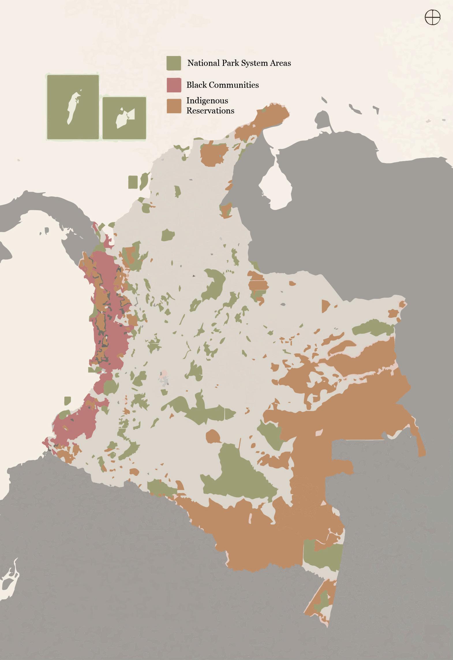
in accordance with the National Constitution.53 Title X of the law (on the modes and procedures of citizen participation), introduces the right to intervene in environmental administrative procedures,54 the publicity of environmental decisions,55 administrative public hearings on environmental decisions,56 the right to request information.57 In addition, Law 99 of 1993 creates the National Environmental Council, which includes members from the national level (ministers), members from the territorial level (a representative of the governors, a mayor representing the Colombian Federation of Municipalities, etc.), and members of private organizations whose functions affect or may affect the environment and renewable natural resources (Article 13), among them: a representative of the indigenous communities, a representative of the black communities, a representative of each of the following: a representative of the agricultural production, industrial production, mining production, exporters, forestry activity; a representative of the non-governmental environmental organizations, a representative of the University. The NEC has some restrictions as it provides for the participation of only one representative of the governors and only one mayor. The Council may also invite public officials and other persons to their sessions “with voice but without a vote” to help better understand issues and make recommendations.58
At a subnational level, the Regional Autonomous Corporations must “promote and develop community participation in programs for environmental protection, sustainable development, and property management of renewable natural resources.”59 Many of these corporations also have provisions to promote the integration of traditional, indigenous communities that inhabit the region and their ancestral methods of environmental management into the process of conservation and the sustainable use of resources.
As already anticipated, the National Council on Climate Change created by Law 1931 of 2018, is composed, among others, of representatives of trade unions, academia and NGOs working on issues related to climate change. This Council has the functions established by Article 5 of the same law which, among others, include: making recommendations to the CICC in matters of climate change management in the national territory; issuing concepts on the implementation of the National Climate Change Policy and its planning and implementation instruments; recommending to the CICC the necessary actions to follow in the coordination of climate change management activities between the productive sectors, academia and social organizations, with the public entities that comprise it; suggesting to the CICC guidelines and criteria in climate change management, for the coordination of actions between the national and territorial levels. These are functions that provide for the formulation of recommendations that, as such, are not obligatory for those who receive them; however, these functions allow representatives of civil society to participate in climate issues in some way.
Because it is primarily aimed at establishing coordination amongst national ministries and between national and regional policies, Decree 298 of 2016 does not stipulate specific venues or mechanisms of participatory governance. The law lists broad categories of stakeholders for whom the law applies (“public, private, and nonprofit entities”) but does not require that they be specifically identified.60 Article 4 encourages the inclusion and participation of citizen voices in climate change policy making, but this is stated as a broad goal and the Decree does not explicitly foresee stakeholders and community identification nor how they would be included beyond representatives from different sectors in the regional nodes.
It is clear that in Colombia participatory governance is not reduced to a system of democratic decision making but represents a model of social and political behavior that sees citizens involved in each stage of the public function, allowing them to actively integrate their opinions and needs in the processes that affect them and see them reflected in the final result.
The set of instruments analyzed allows citizens to intervene directly in urban planning matters and see their input taken into consideration (e.g., on the formulation of the POT), effectively applying the principle of democratic participation enshrined in the Constitution. However, there is still a lot to be done in order to guarantee that both public and private actors comprehend the scope and impact that these tools have and the rights and duties inherent to their activity in the city-building processes61. Indeed, among the provisions requiring citizens’ participation, there do not seem to be any provision forcing planning institutions to take into account citizens’ demands, needs and input (except for the enforcement judicial action that, as such, needs to provide a response to each claim). Moreover, some of the environmental and climate provisions taken into consideration fail to clearly identify stakeholders directly or indirectly affected by climate change planning processes. Finally, there do not seem to be legal provisions that require planning institutions to tailor participatory processes to specific community needs (e.g., indigenous communities needs).
61 Urban Law in Colombia, Urban Legal Case Studies Volume 5, UN-Habitat, https://unhabitat.org/sites/ default/files/downloadmanager-files/Urban%20 legislation-Colombia11.pdf
01.3 DATA COLLECTING AND SHARING
62 Law 1454 of 2011, Article 5.
63 Law 1454 of 2011, Article 7.
64 Law 1537 of 2012, Chapter 2, Article 10, Paragraph 4. Data collection and sharing is an essential component of governance, as it helps public agencies make more informed policy decisions, reveal new correlations and patterns that can help governments address multidimensional challenges, and reduce search and processing times, which in turn helps accelerate decision making and improve efficiency.
A number of data and information collection mechanisms exist in Colombia that allow for better organization, consultation and consistency of data in urban and climate planning. For example, article 112 of Law 388 of 1997 states that municipalities and districts are required to create databases consisting of documents, plans and georeferenced information on their respective jurisdictions. Likewise, the Ministry of Economic Development is required to organize and maintain an urban information system containing data on land, housing, public utilities, public space, urban transportation and collective equipment.
Law 1454 of 2011 (Organic Law of Territorial Planning)
does not specifically address data collection and sharing arrangements for climate planning, but Article 4 establishes the creation of the Territorial
Order Commission (COT)
with the specific purpose of integrating resources between departments.62 In addition, the Technical Secretary of the COT “will be in charge of ensuring the logistical, technical and specialized support that it requires for the full development of its functions and will invite the ministers, heads of the respective administrative departments, academic experts from different universities, the private sector, or whoever it deems necessary, when matters within its competence must be dealt with or when concepts external to the Commission are required.”63 While the COT may be bringing together a range of experts, Organic Law of Territorial Planning does not have language requiring data collection or sharing arrangements of climate sensitive information between territorial entities.
Data collection and sharing is not explicitly mentioned throughout Law 1537 of 2012, except for the preparation of a “list of potentially eligible individuals and families in each Municipality and District in accordance with the targeting criteria used in the programs for overcoming poverty and extreme poverty, or others defined by the National Government.”64 Data collection outside of this context is not currently a component of regulatory processes for Special and Priority Interest Housing programs in Colombia.
In Law 1625 of 2013 (Regime of Metropolitan Areas), Article 7(a) requires Metropolitan Areas “to identify and regulate the Metropolitan Facts, in accordance with the provisions of this law” and Article 10 mandates the evaluation of Metropolitan Facts of “economic, social, technological, environmental, physical, cultural, territorial, political or administrative phenomena that simultaneously affect or impact two or more of the municipalities that make up the metropolitan area constitute metropolitan events.” There is a broad implication of data collection for the Metropolitan Board, Metropolitan Planning Council, and municipalities to create and administer the territorial and metropolitan development plans. Article 26 enables “the required studies [to] be made directly by the members of the councils, or external advisors may be hired.” Article 40 aims “to provide transparency to their actions and keep the citizens informed, the metropolitan areas shall have a web page for the purpose of publishing online and in real time the information regarding their organization, contracting and administrative acts issued by them.”
Regarding disaster risk management, Law 1523 of 2012 outlines implementation strategies for a national disaster risk management information system which must be kept up to date and functional by integrating the contents of all national and territorial entities. The intent is to promote the generation and use of information on disaster risk at all levels of government (Article 45). In addition to a national system, the law provides for departmental, district and municipal authorities to establish information systems for disaster risk management within their jurisdiction in harmony with the national system, guaranteeing interoperability with it.
In the environmental sector, all data is public and environmental agencies have a duty to enable full access to whoever wishes to verify it. Law 99 of 1993 (General Environmental Law) includes legal provisions that require data collection and sharing among different national scientific institutions. IDEAM (Institute of Hydrology, Meteorology and Environmental Studies) is responsible for providing “information, predictions, warnings, and advisory services to the community” and coordinating with the National Institute for Renewable Natural Resources and the Environment (INDERNA) to receive basic general research.65 INDERNA transfers research and information to “Alexander von Humboldt” Biological Resources Research Institute.66 The purpose of the Amazon Institute of Scientific Investigations (SINCHI) is to “carry out and disseminate high-level scientific research studies related to the biological, social, and ecological reality of the Amazon region.”67 Furthermore, the Ministry of National Education, in relation to the environment and renewable natural resources, shall promote non-formal education and outreach programs with the Ministry of the Environment.68
Law 1931 of 2018 (Climate Change Law) and Decree 298 of 2016 coordinate policies across national and regional governance scales, thus information sharing is implied in the laws, although not specifically mandated. The
65 Law 99 of 1993, Article 5.
66 Law 99 of 1993, Article 5.
67 Law 99 of 1993, Article 5.
68 Law 99 of 1993, Article 5.
69 Law 1931 of 2018, Article 26.
70 CONPES 3700 of 2011, https://colaboracion.dnp. gov.co/CDT/Conpes/ Econ%C3%B3micos/3700. pdf
71 CONPES 3700 of 2011, p. 32.
72 https://www.minambiente. gov.co/index.php/cambioclimatico 73 National Climate Change Policy (PNCC), https://www. minambiente.gov.co/index. php/politica-nacional-decambio-climatico
Climate Change Law establishes the National Information System on Climate Change and lists specific instruments to be used for the “generation of official information that allows making decisions, formulating policies and standards for planning, sustainable management of natural forests... and the management of climate change.”69 This includes the establishment of the National Registry for the Reduction of Greenhouse Gas Emissions (RENARE), as one of the necessary instruments for information management of GHG mitigation initiatives. Decree 298 does not include any formal mechanisms or requirements for data collection and sharing. Article 10 does require the nodes to publish their operational regulations within six months of the law’s enactment, but there are no more detailed or ongoing requirements.
Despite the information systems addressed by the laws mentioned above, which allow faster and more transparent access to information, for the exchange of information between scientific institutions and for a better organization of the information (e.g., the urban file that municipalities and districts are obliged to organize), there do not seem to be explicit requirements for the coordinated collection and the exchange of data between the different governmental levels (neither vertical nor horizontal) in the field of urban and climate planning in Colombia. Improved technological infrastructures and capacities are necessary to boost the flow of information, as well as the development of technical capacities within the ministry and territorial entities for data collection and analysis.
The Institutional Strategy for the articulation of policies and actions on climate change in Colombia (CONPES 3700 of 2011)70 suggests that the decision-making process in productive sectors does not adequately reflect the research on the topic. Conversely, if this information is represented, it is not done adequately or is unknown by the key sectoral and territorial actors71. This leads to a lack of knowledge on the part of the sectors and territories of the threats, vulnerability, and economic and financial dynamics related to climate change. Additionally, the strategy stresses that, in the same environmental sphere, the impact of climate change on biodiversity and the services that ecosystems provide to society is unknown.
National adaptation initiatives are insufficient and a better understanding of the relationship between the effects of climate change and biodiversity is necessary. The Strategy’s 2011 suggestion called for a transformation of the Colombian government’s climate change website72 into an information portal for climate change adaptation and mitigation issues. This climate change web page has now changed and represents a true information portal that collects national communications on climate change and identifies all the main laws, policies and mitigation measures adopted by the government in this area, also offering basic and in-depth virtual courses on climate change. The National Climate Change Policy (PNCC), initiated in 2014, recognizes the great challenges associated with the information facing climate change management, sets out the need for adequate human and financial resources, taking into account the importance of adaptation and mitigation information for decision making73. According to CONPES 3700 of 2011, the type of information required is “the result of the generation of future climate scenarios at national, regional and local scales; quantification of the physical impacts on ecosystems, societies and economic activities; estimation of the economic and social costs and benefits thereof”; and vulnerability assessments.
In addition to the need for adequate information, there is a need to align the data collected and produced by ministries, administrative departments and research institutions. The PNCC identifies six institutions that are responsible for the generation of information at the national level and clearly states that they should collaborate with the regional and local levels to achieve institutional integration in this process. The PNCC also proposes that a national information strategy be formulated, focusing on the generation and use of information required to empower climate change management and containing provisions for the publication, dissemination and public approval of climate change management information.
In conclusion, the issues of data collection and exchange are well known to policy makers in Colombia and there is ample evidence that suggests innovations, technologies and technical capacity building is necessary to advance this field.
01.4 LOCAL GOVERNMENTS’ MANDATE FOR URBAN PLANNING IN URBAN AREAS
Local governments have unique knowledge about their territories and about the climate challenges affecting them. They are also more likely to have an accurate appreciation of the needs and concerns of their local population and their authority is more likely to be accepted as legitimate. Rapid urbanization can result in the emergence of human settlements that do not fit entirely within a single municipality but extend across two or more. In this sense, administrative boundaries may not correspond to functional and morphological boundaries, resulting in institutional gaps and deficiencies in the provision of services.
According to article 311 of the Political Constitution, the municipality is the fundamental entity of the political-administrative division of the State; article 330 considers municipalities to be the central
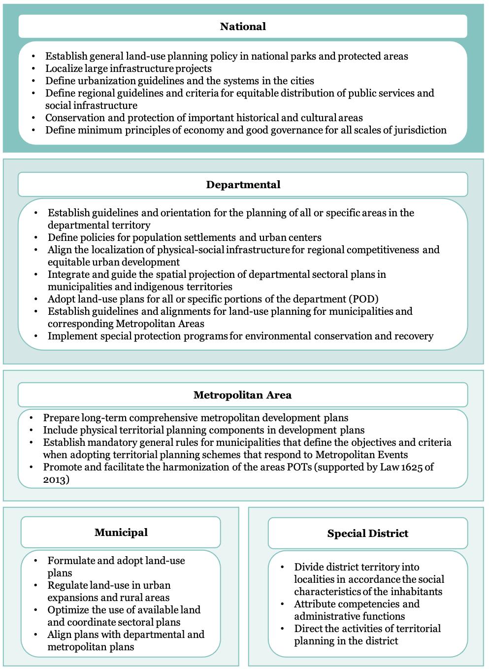
FIGURE 3 Governmental Competencies Assigned by Law 1454 of 2011 entity in the political and territorial planning.74 The Constitution defines specific municipal functions for city councils, who are responsible for plans and social programs related to public service provision, the construction of public works, and overseeing the sale of real estate for housing.75 Municipalities are responsible for regulating the development of their own territories and must regulate land uses and construction processes, though this is subject to department oversight.76 Departments, formed by the union of several municipalities, functions as an entity of intermediation, support, and administrative coordination among the municipalities within its jurisdiction.77 A department can execute and intermediate national functions as they are delegated, complementing municipal actions through cooperation or co-participation. Districts are cities with special primacy over other cities or territorial entities given their economic, social, environmental, or strategic importance to the nation.78 Indigenous territories have functions within their respective jurisdiction established by Article 330 of the Constitution, including enforcing land use and settlement regulations; overseeing the conservation of natural resources; and designing plans and programs for economic and social development in alignment with the National Development Plan.
In the last few decades, significant progress has been made in the management of Colombian territory and, above all, in the national decentralization process. Indeed, each entity enjoys a level of political and administrative autonomy that allows it to set and pursue its own territorial interests and facilitates decentralization. Law 388 of 1997, known as Ley de
Ordenamiento Territorial
(the Territorial Development Law)79, focuses on responsibilities and actions that municipalities and jurisdictions can take to promote urban development in its territories. Articles 5 and 8 of Law 388 of 1997 recognized the territorial autonomy of municipalities and districts, establishing that land use planning and intervention in land use will take the form of specific urban planning actions promoted by the local authorities: the law endowed the municipalities with autonomy to promote the development of their territory. The law includes timelines for implementing plans, differentiated plan types for municipalities with different population levels, as well as the institutional roles (e.g., mayor) that are involved in carrying out certain aspects of a plan. The law requires districts and municipalities to consider the distribution of burdens and benefits across different communities when implementing urban developments.80 This Law also define the specific competences of local entities in matters of territorial planning at its article 7 that, however, was declared unconstitutional by the Constitutional Court of Colombia in 2000.81
As a consequence, Law 1454 of 2011, known as Ley Orgánica
74 Political Constitution of 1991, Article 330.
75 Political Constitution of 1991, Article 311 and Article 313, Paragraph 7.
76 Political Constitution of 1991, Article 334.
77 Political Constitution of 1991, Article 298.
78 Political Constitution of 1991, Article 322.
79 Law 388 of 1997 develops the Territorial Management Plans (in Spanish, “Planes de Ordenamiento Territorial”, POT) as an instrument for territorial planning and management.
80 Law 388 of 1997, Article 49.
81 Decision C-795/00, https://www. corteconstitucional.gov.co/ relatoria/2000/C-795-00. htm
82 Law 1454 of 2011, Article 2.
83 Law 1454 of 2011, Article 2.
84 Law 1454 of 2011, Articles 11 and 16.
of Ordenamiento Territorial,
issued updated rules on Colombia’s legal framework for land use planning and, seeking to “transfer competences and decision-making power” away from the national government to the regional entities82, it defines competences, functions and responsibilities for national government, departments, special districts, municipal governments and metropolitan areas at its article 29 (as shown in the figure on the right). Its aim is “to promote increased capacity for decentralization, planning, management and administration” at the local level and allow for greater territorial integration.83 It aims to articulate National and subnational jurisdictions and establish competencies and roles in a decentralized, regional, and coordinated fashion.
The law encourages territorial entities to work with one another to coordinate and “jointly organize the provision of public services, the execution of regional works and the execution of comprehensive development projects, as well as environmental management.”84
Article 30 of Law 1454 of 2011, as amended by Article 4 of Law 1962 of 2019 (the Regions Law), provides for the possibility for the governors of two or more departments to voluntarily establish an Administrative and Planning Region (RAP). RAPs are legally and administratively autonomous, with missions to promote economic and social development, investment, and regional competitiveness. Their functions include: promoting a regional development approach; promoting the coherence and articulation of planning actions among their component territorial entities; designing and promoting the execution of plans, programs and projects that are of mutual interest of the entities that comprise it; promoting the incorporation of the regional approach in Land Management Plans, the Departmental Management Plans, Development Plans, and other planning instruments.
Article 32 of Law 1454 of 2011, as modified by Article 5 of Law 1962 of 2019, designates the RAPs will be financed with the resources coming from the territorial entities that constitute that specific RAP, plus the incentives allocated by the Government. The law also establishes the possibility for RAPs to access resources from the general royalty system by submitting investment projects. Another purpose of the Law 1962 of 2019 is to establish the conditions for converting RAPs into Territorial Entity Regions (RET) which will become possible in 2022. The law provides a nonexhaustive list of powers that may be complemented by additional powers conferred in the creation of a RET, though the law does not include specific financial resources or the power for regions to adopt their own taxes.
Law 1551 of 2012 modernized the organization and operation of the municipalities and reiterated the competence of municipalities in the adoption of land use plans, clarifying their role in surrounding rural areas and promoting harmonization with other national, departmental, and municipal plans. In Article 3, the law lists 23 points elaborating the functions of municipalities, including the mission to implement municipal development plans in accordance with the National Development Plan, departmental plans, life plans of territories and indigenous areas, and “incorporating the visions of ethnic minorities, community organizations and vulnerable population groups present in their territory, taking into account the criteria and instruments defined by the Planning Unit for Rural Land and Agricultural Uses (UPRA).”85 This articulation places each municipal plan in conversation and context with other territorial and governmental plans.
Law 1625 of 2013 (Regime for Metropolitan Areas),
in contrast to its predecessor Law 128 of 1994, adds specific provisions enabling metropolitan areas to have the authority to carry out environmental planning by creating “joint commissions for the regulation and administration of the ecosystems or basins shared with other environmental authorities.”86 Articles 10 to 13 further define the areas’ environmental planning competencies by mandating they develop “guidelines for the location of transportation infrastructure, public services, equipment and public spaces of metropolitan scale; as well as the reserve areas for the protection of the environment, natural resources and landscape, [and] the determination of strategic areas susceptible to be declared as protected areas.”87 Article 24 joins with the preceding sections to enable metropolitan areas and entities within them to create the fiscal, land, contracting, and labor capacities to necessary to carry out their plans (article 13).
Law 152 of 1994 (Organic Law of the Colombian Development Plan) establishes the procedures and mechanisms for the preparation, approval, execution, evaluation, and control of the development plans for territorial entities, and also provides for the preparation of land use plans for municipalities.88
Legal provisions that facilitate informal and flexible intermunicipal collaborations for urban planning, when administrative boundaries do not correspond to functional boundaries and morphological boundaries, exist within Colombian legislation in both the Constitution and national laws. Articles 318 and 319 of the Constitution facilitate this type of coordination, which can take several forms; for example, the organization of two or more jurisdictions sharing economic, social, and/or fiscal relations as an “administrative entity”.89
Law 128 of 1994 (Organic Law of Metropolitan Areas)
supplements this function by addressing functional and morphological boundaries as they relate to Regional Autonomous Corporations, though the specific needs of informal settlers and indigenous groups are not specifically taken into consideration for these kinds of collaborations.90 Modifications to legislation of this variety should consider inter-municipal collaborations that consider the specific realities of slums and indigenous communities.
85 Law 1551 of 2012, Article 3.
86 Law 1625 of 2013, Article 9.
87 Law 1625 of 2013, Articles 10 – 13.
88 Law 152 of 1994, http:// www.secretariasenado. gov.co/senado/basedoc/ ley_0152_1994.html
89 Constitution of Colombia, Article 318 and 319
90 Law 128 de 1994 (Ley Orgánica de las Áreas Metropolitanas)

91 Law 1537 of 2012, Chapter 1, Article 1.
92 Law 1537 of 2012, Chapter 1, Article 1.
93 Law 99 of 1993, Article 1.
94 Law 99 of 1993, Article 1. Local governments’ roles and responsibilities are assigned the mandate for urban planning in their areas by Law 1537 of 2012 related to housing and basic home infrastructure. Article 1 of Chapter 1 expresses that one of the purposes of the law is to “establish instruments for the planning, promotion and financing of territorial development, urban renewal and the provision of potable water and basic sanitation services.”91 Chapter 1 defines institutional “competencies, responsibilities and functions of the national and territorial entities, and the confluence of the private sector in the development of Social Interest Housing projects and Priority Interest Housing projects for lowincome families, the promotion of territorial development, as well as to encourage the specialized housing financing system.”92 While institutional roles are explicitly defined by Law 1537 of 2012, it is unclear in many circumstances whether the jurisdictions of certain entities are geographically bound or designated to specific urban areas. Law 1537 of 2012 is specific to housing and, thus, does not address capacity building of local governments or the implementation of local government mandates. It also lacks provisions pertaining to administrative boundaries or their relationship to functional and morphological boundaries.
Specifically on the environmental and climate areas, the General Environmental Law (Law 99 of 1993) clearly defines institutional roles and responsibilities as a decentralized and democratic process.93 Article 1 also supports local governments in building their capacities to implement environmental mandates, and highlights the importance of coordination between public and private actors, stating that “action for the country’s environmental protection and recovery is a joint and coordinated task between the department, community, nongovernmental organizations and the private sector.”94 The functions at departmental level are defined by article 64 : to promote and execute national, regional and sectorial programs and policies related to the environment and renewable natural resources, and to provide budgetary, technical, financial and administrative support to the Regional Autonomous Corporations, the municipalities and other territorial entities in the execution of these programs and policies; to issue, subject to higher regulations, special departmental provisions related to the environment; to exercise control and surveillance functions of the environment and renewable natural resources.
The functions of municipalities and districts are listed in article 65 of the same law, completed by article 66 in relation to large urban centers and applied to indigenous territories by provision of article 67. Among the main functions, it is worth to notice the followings: to promote and execute national, regional and sectorial programs and policies in relation to the environment and renewable natural resources; to elaborate municipal environmental plans, programs and projects articulated with regional, departmental and national plans, programs and projects; to dictate, within the limits established by law, regulations and superior dispositions, the norms of territorial ordering of the municipality and the regulations on land use, as well as the necessary norms for the control, preservation and defense of the ecological patrimony of the municipality.
Additionally, Article 23 states that the Regional Autonomous Corporations (CARs), which are public corporate entities that, due to their characteristics, geographically constitute the same ecosystem or form a geopolitical, biogeographical or hydrogeographical unit, with administrative and financial autonomy, their own assets and legal personality, will administer environmental management and natural resources in the area of their jurisdiction and in close coordination with local territories (participating, for example, in the territorial planning and management processes, in order to ensure that the environmental factor is taken into account in the decisions adopted at the territorial level).
FIGURE 2 Articulation and Coordination for Climate Change Management
Source: Política Nacional de Cambio Climático (PNCC) (National Policy on Climate Change)
While the General Environmental Law makes provisions for local governments to build capacities and execute roles and responsibilities, the law lacks provisions that facilitate informal inter-municipal collaborations when administrative boundaries do not correspond to functional or morphological boundaries. Furthermore, there is no clear vision of the role local governments will play in collaboration with CARs.
The Decree of 2016 creating the SISCLIMA system also defines the mandates at local level within this system. The territorial entities are responsible for the formulation of the comprehensive territorial climate change management plans, with the support of the regional environmental authorities. Likewise, they may guide the departmental risk management plans, taking into account the studies of alternatives and recommendations on climate change adaptation that are defined in the comprehensive territorial climate change management plans. This requires close coordination with the municipalities and districts within their territorial jurisdiction, as well as with the Departmental, District and Municipal Disaster Risk Management Councils.
The departments must establish the bases and instruments to promote the strengthening of institutional and sectorial capacities to face climate change, design and promote the establishment and application of incentives that promote the execution of actions to comply with the object of the Law; promote the co-responsible participation of society in adaptation and mitigation, in accordance with the provisions of the applicable departmental ordinances; and develop strategies, programs and comprehensive projects for the mitigation of greenhouse gas emissions to promote efficient and sustainable public and private transportation. On the other hand, all municipalities and districts or metropolitan areas must formulate a comprehensive territorial climate change management plan for their municipal or district jurisdiction. The regional environmental authorities, within the framework of their mission functions, will be in charge, jointly with the governors’ offices, of providing technical support for the preparation of comprehensive territorial climate change management plans, as appropriate. The functions of these regional environmental authorities (including the CARs) are further defined by the Law 1931 of 2018, which provides other responsibilities for departments, districts, and municipalities including requirements for subnational participation in national and regional plans, though the law does not require coordination among municipalities at the local level. However, the Climate Change Law does include clear roles and responsibilities for respective local governments through the
Comprehensive Sectoral Climate Change Management
Plans (PIGCCS) and
Comprehensive Territorial Climate Change Management
Plans (PIGCCT), which define the need for territories, districts and municipalities to complete climate change management plan.
The number and variety of these laws and decrees confirm that the functions and responsibilities of the institutions involved in urban and climate planning in Colombia are defined by a broad and constantly evolving regulatory framework, which reflects the large number of sectors and actors involved in land use and climate planning in Colombia, as well as the strict interconnections between urban planning and environmental and climate issues. However, the abundance of legislation brings to the light the issue of implementation of the ample set of regulations, laws, projects and policies.
Indeed, the decentralization of competencies has not been accompanied by an appropriate fiscal decentralization: for the most part, competencies were ceded and resources to finance them were distributed to subnational governments, without transferring fiscal competencies to them. According to the Colombian Constitution, municipalities are entitled to administer their own resources and to collect the taxes necessary to the performance of their functions “within the limits imposed by the Constitution and the law” (Art. 287). The extent of local government taxing powers thus depends upon the terms of the law that authorize the levy of each specific tax. As a general rule, the national Congress must define the basic elements of the tax, such as its base and rate. In practice, a range of rates are often established, within which municipalities are free to choose. The same rule applies for fees and special levies (“contribuciones”), with the important exception that the rate can be determined directly by municipalities as long as they follow the procedures established by Congress.95
As a result, local authorities have financial limitations that often mean they are under-resourced and lack the basic information and qualified technical teams required for preparing comprehensive land use plans. Limited autonomy in making fiscal decisions has been noted and neither the decentralization process initiated by the Constitution nor the various reforms of the 1990s introduced fundamental changes that would allow local governments to raise their own fiscal resources, meaning they depend mainly on the resources distributed by the national government.
In order to fiscally strengthen territorial entities, the national government has issued a series of laws which sought to introduce fiscal discipline rules and limits on expenditures in order to free up revenues to finance municipal competencies, including those related to territorial planning96: Law 617 of 200097 adds to the Organic Budget Law and establishes rules to strengthen decentralization; Law 819 of 200398 includes provisions on territorial entity budgets, fiscal responsibility, and transparency; and, Law 550 of 199999 addresses related issues. Moreover, the Project for Strengthening Territorial Entities (PFET)100
95 Natalia Aristizabal (Harvard Law School), “Land Taxes in Colombia”, World Bank, http://www1.worldbank.org/ publicsector/decentralization/ June2003Seminar/Colombia. pdf
96 CONPES 3870 of 2016, National Program for the Formulation and Updating of Land Management Plans: Modern POT, https://colaboracion.dnp. gov.co/CDT/Conpes/ Econ%C3%B3micos/3870.pdf
97 Law 617 of 2000, http:// www.secretariasenado. gov.co/senado/basedoc/ ley_0617_2000.html
98 Law 819 of 2003, http:// www.secretariasenado. gov.co/senado/basedoc/ ley_0819_2003.html
99 Law 550 of 1999, https:// www.funcionpublica.gov.co/ eva/gestornormativo/norma. php?i=6164
100 https://colaboracion.dnp. gov.co/CDT/Desarrollo%20 Territorial/Portal%20 Territorial/KIT-OT/05Proyecto-de-Fortalecimiento. pdf
101 CONPES 3870 of 2016.
102 Constitution of Colombia, Article 318 and 319
103 Law 128 de 1994 (Ley Orgánica de las Áreas Metropolitanas) was launched to strengthen the institutional, administrative and technical capacities of the territorial entities and, in particular, of the municipalities to facilitate regional development. The project proposed regulatory adjustments to make the current distribution of competencies and resources among territorial entities more effective. In addition to the PFET, other instruments like private contracting have aimed at mobilizing quality investments while deepening decentralization (for example, investments for the updating of POTs and the formulation of PODs).
However, despite the attempts mentioned, local authorities still have financial limitations that affect their ability to have the inputs, basic information and qualified technical teams that are indispensable for the preparation of comprehensive and quality land-use plans101, with undeniable consequences for the effective performance of their functions. The current regulatory framework is not sufficient to allow territorial entities to effectively plan their development.
Legal provisions that facilitate informal and flexible intermunicipal collaborations, for urban planning, when administrative boundaries do not correspond to functional boundaries and morphological boundaries exist within Colombian legislation in both the Constitution and supplementary laws. Articles 318 and 319 of the Constitution facilitate inter-municipal coordination for urban planning. While this type of coordination can take several forms, the most significant in terms of urban planning practices is outlined within Article 319 suggests that the organization of two or more jurisdictions sharing economic, social, and/or fiscal relations as an “administrative entity”.102
Law 128 of 1994 (Organic Law of Metropolitan Areas)
supplements this function by addressing functional and morphological boundaries as they relate to Regional Autonomous Corporations, though informal entities such as indigenous and informal settlers are excluded from these kinds of collaborations.103 Modifications to legislation of this variety should consider informal collaborations and groups.
SUMMARY OF KEY FINDINGS
Colombia since 1991 has enacted laws that establish a system for environmental governance. The country lives through a wave of evolving climate change laws and policies that establish new climate governance networks.
Climate and environmental governance in Colombia rely on building vertical and horizontal relations among existing government bodies as well as establishing brand new regional territories of climate governance, although there are few legal provisions that require coordination among different line departments in local governments. In addition, the environmental and climate laws provide limited guidance on how local governments should implement environmental management and preservation beyond coordinating with Regional Autonomous Corporations.
More broadly, many legislative provisions foresee the need for vertical coordination and there are several provisions creating bodies to support multi-level institutional governance. However, more mechanisms and processes for horizontal coordination would be beneficial (such as coordination from municipality to municipality), as well as urban-rural coordination beyond administrative boundaries, that take into consideration rural needs when rural areas are part of the same economic, social or environmental functional areas even if within the boundaries of two or more local government authorities. Participatory governance is enshrined in the Constitution and guaranteed from subsequent legislation. Mechanisms include direct citizen participation and stakeholder representation, as well as the requirement to consider citizens’ inputs in some cases, although institutions are not obliged to take into account community demands, input and needs. Stakeholders and community identification is not clearly foreseen, especially in environmental and climate legislation.
The National Constitution and Law 1454 even highlight the importance of including indigenous and rural peoples in planning processes. This is very important, as indigenous and rural people often face climate adaptation in increasingly severe ways than those in urban areas.
There do not seem to be explicit requirements for the coordinated collection and the exchange of data between the different governmental levels (neither vertical nor horizontal) in the field of urban and climate planning. More alignment of the data collected and produced by ministries, administrative departments and research institutions is needed, as well as collaboration with the regional and local levels to achieve institutional integration in this process. Moreover, there is a need for adequate information.
Decentralization is well established as a national strategy and set of goals, and the roles and mandates
of the territorial entities in land use planning are comprehensively established; however, there is a certain abundance and disarticulation of legislation defining the competences of national, subnational and local governments in the different sectors related to urban, environmental and climate planning, which, although it reflects the large number of sectors and actors involved in land use and climate planning in Colombia, could create overlaps and confusion due to the strict interconnections between the several sectors involved.
The decentralization of competencies has not been accompanied by fiscal decentralization: for the most part, competencies were ceded and resources to finance them were distributed to subnational governments, without transferring fiscal competencies to them. Local authorities have financial limitations that often mean they are under-resourced and lack the basic information and qualified technical teams required for preparing comprehensive land use plans with undeniable consequences for the effective performance of their functions. They also have limited autonomy in making fiscal decisions and they depend mainly on the resources distributed by the national government.
RECOMMENDATIONS
Define and create coordination mechanisms (in addition to territorial associative schemes) to facilitate horizontal collaboration at city level and urban-rural coordination, as well as more tools and structure for coordination between different line departments and sectors at all levels (national, subnational and local). In particular, urbanrural coordination beyond administrative boundaries would help in comprehensively taking into consideration the need of a rural territory strictly interconnected for social, economic or environmental functions, although part of different municipalities.
Create mechanisms for an effective participatory planning process, including requirements to take into consideration citizens’ demands, input and needs. Especially in environmental and climate legislation, specify requirements related to stakeholder and community identification.
Define and create mechanisms and structures to boost the flow of information and collaboration between institutions at all levels on data collection and sharing, enhancing vertical and horizontal alignment of data collected and produced. To this end, improved technological infrastructures and innovations are necessary, as well as the development of technical capacities within the ministries and territorial entities for data collection and analysis.
Territorial entities are vital actors in guaranteeing urbanrural balance, solving territorial conflicts, and closing of territorial gaps. As such, the national government should undertake substantial fiscal decentralization to increase the institutional and technical capacities of territorial entities to formulate, manage, and implement the POTs. For example, subnational tax reform that would allow territorial entities to generate greater local own revenues would be beneficial. A potential measure could be the local property tax assessments at local level, instead of national (e.g., a few municipalities, like Bogotá and Medellin, have their own cadastre offices; this has allowed Bogotá to increase its property tax base substantially)104 .
Colombian legislation pertaining to informal and flexible intermunicipal collaborations for urban planning, when administrative boundaries do not correspond to functional boundaries and morphological boundaries, should give further consideration to indigenous groups and slum dwellers.
104 Fedelino, A. (2010). "6 Colombia1". In Making Fiscal Decentralization Work : Cross-Country Experiences. USA: INTERNATIONAL MONETARY FUND. doi: https://doi. org/10.5089/ 9781589069855.084
02
PLANNING INSTRUMENTS
National territorial planning
Regional territorial planning
Spatial Plans for Urban Areas
Does your country have provisions in legislation or regulations requiring the formulation of a national territorial plan?
Do these include legal provisions that require the national territorial plan to classify national land according to its use, for example in urban and nonurban?
Do these include legal provisions that require the national territorial plan to establish an integrated national inland and coastal transportation and infrastructure network?
Do these include the legal requirement to coordinate the national territorial plan with national climate plans?
Do these include the legal requirement to assess the climate vulnerability of the implementation of the national territorial plan?
Do these include the legal requirement to assess the greenhouse gas emissions associated with the implementation of the national territorial plan?
Does your country have provisions in legislation or regulations requiring the formulation of regional territorial plans?
Does your country have provisions in legislation or regulations requiring the formulation of regional territorial plans?
Do these include legal provisions that require regional territorial plans to establish an integrated transportation network and infrastructure system?
Do these include legal provisions that require the coordination of the regional territorial plans with national climate plans?
Do these include legal provisions to ensure that regional plans implement the objectives of the national territorial plan?
Do these include the legal requirement to assess the climate vulnerability of the regional territorial plans?
Do these include the legal requirement to assess the greenhouse gas emissions associated with the regional territorial plans?

02 PLANNING INSTRUMENTS
2.0
Planning frameworks vary among countries but most of them have a three-tiered hierarchy with national, sub-national (regional) and local levels. The national framework often identifies the broader objectives of planning and strategies for implementation. These are then adopted and tailored at the sub-national and local levels through subnational (regional) plans and local (urban) plans respectively.
Planning instruments play an important role in reducing greenhouse gas emissions, while increasing resilience through adaptation strategies that promote social equity and economic prosperity. For most countries, territorial planning law and instruments precede climate change legislation and policies. This is the case with Colombia, where many robust planning laws do not reference specific climate adaptation policies. So far, the legal analysis has not identified any legal requirements to coordinate the national territorial plan with the national climate plan. Colombia has robust environmental laws to guide territorial planning and these regulations are important for climate change mitigation and adaptation, even if greenhouse gases emissions are not mentioned. Planning instruments are integral in climate change considerations as they enable and standardize the national, territorial, and municipal objectives and policies for land-use, urban expansion, city and regional infrastructure, and environmental protection. Planning legislation in the 1990s “provided municipalities with better instruments to realize urban development processes based on tolerance, democracy and justice,”1 and deliberate and delicate land-use decisions can protect non-urban populations and environmental features as cities expand. According to the World Bank, 81.1 percent of Colombia’s population lives in cities, and with a growth rate of 1.76,2 urban areas will continue to grow in the coming years. Unfortunately, this leaves land in the urban periphery vulnerable to real estate and urban development stakeholders, even if the land is classified as agricultural or protected.3 Additionally, the agricultural land critically supports food production for the region and contributes to tourism, trade, and handicraft sectors.4 Losing rural land uses and the cultural, social, ecological knowledge of rural peoples would be detrimental to the sustainability of Colombia’s cities.
1 Koch, Florian. “The Rules of the Game and How to Change Them: Urban Planning Between Formal and Informal Practices. A Colombian Case Study.” International Planning Studies 20, no. 4 (October 2, 2015): 407–23. https://doi.org/10.1080/1356 3475.2015.1068685.
2 World Bank. “Urban Population (% of Total Population) - Colombia | Data.” Accessed March 16, 2021. https://data.worldbank. org/indicator/SP.URB.TOTL. IN.ZS?locations=CO.
3 Quimbayo Ruiz, Germán A., Juha Kotilainen, and Matti Salo. “Reterritorialization Practices and Strategies of Campesinos in the Urban Frontier of Bogotá, Colombia.” Land Use Policy 99 (December 2020): 105058. https://doi.org/10.1016/j. landusepol.2020.105058. p 1.
4 Quimbayo Ruiz, Germán A., Juha Kotilainen, and Matti Salo. “Reterritorialization Practices and Strategies of Campesinos in the Urban Frontier of Bogotá, Colombia.” Land Use Policy 99 (December 2020): 105058. https://doi.org/10.1016/j. landusepol.2020.105058. p 5.
5 Koch, Florian. “The Rules of the Game and How to Change Them: Urban Planning Between Formal and Informal Practices. A Colombian Case Study.” International Planning Studies 20, no. 4 (October 2, 2015): 407–23. https://doi.org/10.1080/1356 3475.2015.1068685. p. 417.
6 Echeverria, Maria Clara. “Urban Reform in Colombia: A Tool for Democratic Development?” Cities, May 1991. After the decentralization and implementation of early planning instruments, development in many Colombian cities, like Barranquilla, happened very quickly.5 Plans like the Territorial Ordering Plan (POT) developed urban planning strategies that placed timeframes on developers for construction. Developers, reluctant to sell undeveloped land back to the City, built quickly, which subsequently encouraged urban growth.
Pace of development was not the only impact of early planning legislation. Prior to 1990s laws, urban growth and management were difficult to control across cities, territories, and departments, and negative impacts from rapid urbanization were increasing.6 Colombia’s new at the time planning laws introduced important requirements for development plans across all governmental levels, created expectations for environmental protection and urban growth, addressed settlement legalization, and established standards for public and social infrastructure and amenities. These early planning practices were fundamental to centering the decentralization process and normalizing concepts that would become climate change considerations (i.e., protected areas, hazard areas, transportation, and land-use). Figures 1 and 2 show Colombia’s key planning instruments and the chronology of the country’s planning laws.
Key Findings are as follows: Where the toolkit is concerned, many of the planning instruments facilitate and guide the planning process even when there are no legal requirements to do so. The radar graphic above shows that many of the toolkit responses were “No.” This is because of a lack of legal requirement for most of the planning instruments. Due to Colombia’s decentralization objectives, many planning instruments are identified for national, regional, and municipal entities. Numerous of these documents are still in the process of including climate change specific elements, like vulnerability and greenhouse gas assessments. The genealogy of Colombia’s urban planning legislation and policy is extremely robust. In some areas, this creates a lack of clarity on which planning authorities have decision-making power, capacity-building responsibilities, or research and knowledge responsibilities.
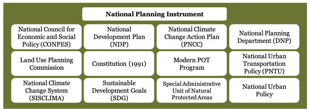


FIGURE 1 Key Planning Instruments
7 Colombia Country Note, Latin American Economic Outlook 2019, Organisation for Economic Co-operation and Development (OECD), https://www.oecd.org/ dev/americas/ColombiaCountry-Note-Leo-2019.pdf
02.1 NATIONAL TERRITORIAL PLANNING
Considering that the function of planning is to promote balanced socio-economic development with environmental considerations, classifying land with allowed uses enables these objectives to be achieved in a coordinated manner. It allows the protection of ecosystems that perform mitigation and adaptation functions (such as mangroves) and restricts urban development in risky areas, ensuring planning in safe places. For instance, it makes it possible to increase the housing stock without destroying green zones and facilitates renewal without the loss of cultural heritage. This classification is especially important in a biodiverse country like Colombia, although there is no specific section in Colombia’s legislation that foresees the determination of actions based on the ecosystem to be considered (Amazonian, Orinocense, Andean, Caribbean, Pacific, or insular).
The 1991 Constitution established that the National Development Plan (NDP), a key planning instrument at the national level, must be prepared with active participation from planning and territorial entities. The NDP 2018-22, “Pacto por Colombia, Pacto por la equidad” (Pact for Colombia, Pact for Equity), includes the areas of environmental sustainability, transport and logistics, public services in water and energy, ethnic groups, people with disabilities, and equality for women, among others.7 The NDP is a key planning instrument that develops regional
FIGURE 2 Chronology of Planning Instrument Laws pacts that identify and prioritize highlighted goals. These pacts focus on interconnecting the nine subnational territories in the country. The national pact applies in all territories and seeks to strengthen governance in sub-regions and develop strategic initiatives to activate the regions. The NDP 2018-22 has been designed to help fulfil commitments towards the 2030 Agenda and its Sustainable
Development Goals (SDGs).
The SDGs have served as a tool for promoting coherence within and among the different sections of the plan, as well as a key reference for setting targets aligned with a longterm vision of the country.8
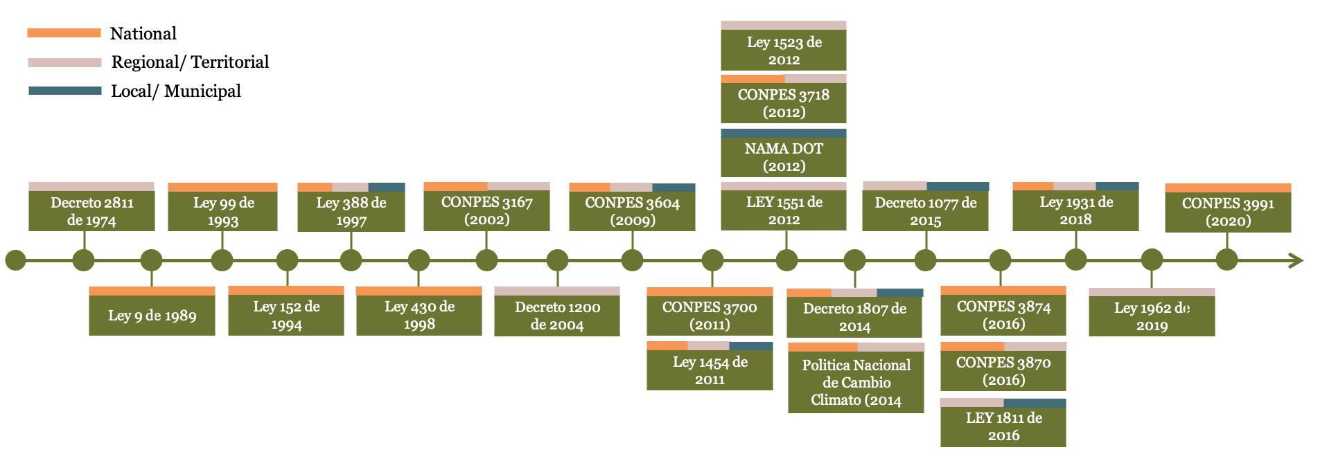
Law 388 of 1997, Ley de Desarrollo Territorial (Law
of Land Development), highlights general land classification categories for each level of government (national, department, and municipal, and district).9 Compliance between these levels of government is outlined in the objectives of the law, Article 1, and the principles, Article 2. In Article 2, the principle “the social and ecological function of property” implies climate concerns, and Article 10 covers natural hazard risks and preventions through territorial planning. Article 8 defines urban planning actions to concern land expansion, hazardous activities and land uses, transportation characteristics, green areas, building and land use intensities, disaster recovery and prevention areas, and undeveloped areas at risk of natural hazards. These actions are further detailed by subsequent regulations, which are compiled under the Decree 1077 of 2015 (Unified Decree
of the Ministry of Housing,
City and Territory). Decree
8 Colombia Country Note, Latin American Economic Outlook 2019, Organisation for Economic Co-operation and Development (OECD), https://www.oecd.org/ dev/americas/ColombiaCountry-Note-Leo-2019.pdf
9 Law 388 of 1997, Article 7.
1077 of 2015 does not explicitly require coordination between multi-level development and land use plans, though coordination between multi-level governmental units is required to formulate and implement the urban land use and development objectives, urban and rural climate mitigation and adaptation measures, and other planning instruments for planning and development.
Law 1454 of 2011 (The Organic Law of Territorial
Planning) recommends norms regarding the political and administrative organization of territories, establishes the guiding principles of land use planning, defines the institutional framework and instruments for territorial development, defines competencies in land use planning between the nation, territorial entities and metropolitan areas, and establishes general norms for territorial organization. Two instruments stem from this law: land use planning guidelines and the Departmental Management Plan (POD). Although the law did not regulate the POD, it did create them as an instrument. Also noteworthy is the creation of the Land Use
Planning Commission (COT)
as a technical and advisory body to both the national government and Congress in matters of decentralization and land use planning. Law 1454 of 2011 outlines land use planning prerogatives for national, regional, departmental, municipal, and indigenous territorial levels of government: “The territorial ordering will propitiate the conditions to agree on public policies between the Nation and the territorial entities, with recognition of the geographic, historical, economic, environmental, ethnic and cultural diversity and regional and national identity.” Land use classifications are not specified as this law primarily focuses on the land use planning process; in Article 29, the Nation is assigned land use competency in regards to land uses of national interest, like national parks and protected areas.
Climate change strategies or action plans are also not specified in Law 1454 of 2011, though the land use planning process in Article 3 includes direction to promote environmental sustainability. Article 9 identifies Regional
Autonomous Corporations
(CARs) to manage environmental and ecological planning, especially for water-producing areas. Although not explicit, Article 28 states that “municipalities are holders of any competence that is not expressly attributed to the departments or the Nation,” which could include climate action planning. Article 30 of Law 1454 was amended by Law 1962 of 2019, Article 4, to include functions for Administrative and Planning Regions (RAP, in Spanish). These amendments include a responsibility for RAPs to develop a regional approach to “environmental particularities” and, overall, use “different planning instruments” to achieve its goals and comply with the National Development Plan.
One of the most traditional planning bodies in the country, the National Council for Economic and Social Policy (CONPES), was created in 1958. As the highest national planning authority, CONPES enacts guidelines and strategies. The National Planning Department acts as the Executive Secretariat of CONPES. In 2011, CONPES 3700 (2011) launched a national strategy to coordinate the implementation of the National
Climate Change Action Plan
(PNCC), recommending the creation of the National Climate
Change System (SISCLIMA)
via decree to provide guidance to all levels of government on climate change objectives and in all spheres of national development. Decree 298 of 2016 establishes the national policy of SISCLIMA to guide the development and coordination of Colombia’s climate change policies. The law creates the Intersectoral Commission on Climate Change (CICC, in Spanish), which regularly brings together the heads of Colombia’s national executive ministries for the purpose of coordinating climate policy. The law also creates regional climate change nodes, required by law to be led by a coalition of public, private, and nonprofit sector representatives for the purpose of developing region-specific climate change policies and plans, and for coordinating between national and regional policies as well as between regions. The PNCC (2014) guides “the inclusion and implementation of adaptation and mitigation actions in planning instruments in territorial planning instruments (e.g., development territorial planning instruments), municipal development plans (e.g., land-use plans, regional plans), regional disaster risk management plans (e.g., four-year action plans) among others.” Topics of focus also include transportation planning and urban expansion. Cohesion between multiple levels of government and development plans are necessary for effective climate change action strategies.
Significant progress has been made in the management of Colombian territory and, above all, in the decentralization process in which the Colombian State has been engaged for several decades, with Law 388 of 1997, known as the “Territorial Development Law,” which develops the Territorial
Management Plans (POT)
as an instrument for territorial planning and management
Through the Modern POT program, as described in CONPES 3870 (2016), the national government will assist territorial entities with tools and capacities that will enable them to adequately face urban-rural challenges associated with population growth and urbanization. Other related issues are: “competitiveness, efficient and sustainable land use, design and implementation of modern road and transportation systems, sustainable expansion of public service networks, disaster risk management, adaptation to climate change, protection and conservation of natural resources, fiscal strengthening, increased efficiency of public investment and attraction of private investment.” The program includes two technical assistance components: the first, of national scope, includes articulation and technical support to central government agencies in the improvement of
10 CONPES 3718 (2012).
11 CONPES 3718 (2012). land-use planning instruments and methodologies. This would guarantee the incorporation of state-of-the-art technical and technological parameters for land use planning and support subnational governments with optimal instruments. The second component, focused on territorial entities, contemplates technical and financial support conditioned to the adoption of the program’s standards and methodologies by the eligible territorial entities. To this end, these entities and the national government, through the National Planning Department (DNP), will complement technical and financial efforts to formulate management plans with the support of external operators and the assistance of national and international experts.
CONPES 3718 (2012), according to Decree 1504 of 1998, identifies “weaknesses in the application of instruments for planning, ordering and designing public space in territorial entities and environmental authorities” at the national level.10 This lack of clarity makes sound decisionmaking around public space during the urbanization process difficult to achieve. CONPES 3718 recommends creating standard methodologies for incorporating public space into urban development planning. Section IV, “Strategies,” recommends the “consolidation of public space as a strategic and articulating element or component of territorial planning. Mainly, as a determinant of urban design from the POT and other instruments that complement it, and the Special
Management and Protection
Plans (PEMP), and integrator of the different uses and systems that make up the city and its environment.”11
Law 99 of 1993, Ley general Ambiental (General Environmental Law) establishes the basis of Colombia’s environmental policy. Primarily, this law outlines the guidelines, goals, and governmental entities for Colombia’s environmental policy, as well as reiterating and supporting the Constitution on the rights of people and the ecosystems of the country. Climate considerations are not explicitly highlighted; Article 5, numeral 35; Article 31, numeral 23 and Paragraph 3, all reference territorial and urban planning to adapt or mitigate natural disasters or ecological risk. Article 5 also assigns the Ministry of the Environment (MoE) the responsibility of “issu[ing] and updat[ing] the zoning statute for the proper use of the territory for its proper ordering and national regulations on land use with regard to its environmental aspects and set the general guidelines for the ordering and management of hydrographic basins and other areas of special handling.” Numeral 7 of Article 5 specifies that MoE, with the Ministry of Economic Development, formulate the national policy for the human settlements and urban expansion.
Law 152 of 1994, Ley Orgánica del Plan de Desarrollo de Colombia (Organic Law of the
Development Plan) establishes “the procedures and mechanisms for the preparation, approval, execution, follow-up, evaluation and control of the development plans” for the Nation and all the territories and public bodies within. This law directly supports Article 342, and in general Title XII, Chapter 2 of the Constitution. Climate action provisions on land use and transportation are not direct requirements in the law, though Article 3, Parts (h) and (i) call for harmonious planning of within and between territories and regions for humans and the natural world. Article 32 issues the scope of planning in the territorial entities; they have “autonomy in matters of economic and social development planning and environmental management, within the environmental management, within the framework of the competencies, resources and responsibilities attributed to them by the Constitution and the law.” Although the territorial entities have autonomy to develop their plans in matters of economic, social and environmental management, they must do so within the parameters of the national framework. Authorities within indigenous territories share the same autonomy and responsibility, per Articles 31 and 32.
Law 1931 of 2018, Ley de
Cambio Climático (Climate
Change Law) requires the Ministry of the Environment and Sustainable Development and the National Planning Department to reference the National Climate Policy when developing guidelines for planning for climate change and ensuring that the Integral
Sectoral Climate Change
Management Plans (PIGCCS) is considered in instruments of land planning and development.12 Article 3, Numeral 4 identifies land use as a possible contributor to climate change; in Article 7, “the National Government will regulate Article 10 of Law 388 of 1997 within the framework of its competencies, with the purpose of including the management of climate change among the determinants of territorial planning.”
Decree 2811 of 1974 established the Watershed Management
and Ordination Plans
(POMCA). POMCA “is the instrument through which the planning of the coordinated use of the soil, water, flora and fauna and the management of the basin is carried out, in which the population that lives in the territory of the basin participates, conducive to the proper use and management of such resources.”13 One of the goals of the POMCA is that it will “guide the structuring of the programmatic component and the measures for the administration of renewable natural resources as established by Decree 1076 of 2015.”14
In general, there is a need for policies to strengthen transport connectivity and electromobility between cities, and policies to enhance active urban mobility based on available infrastructure. Coordination between territorial planning, especially land use and transportation, is essential to accelerate climate action in cities. In 2002, the national government formulated the National Urban Transportation Policy (PNTU, in Spanish), which materialized with the implementation of public transportation systems in seven
12 Law 1931 of 2018, Article 17.
13 Minambiente, “Watershed Management and Ordination Plans – POMCA”, https:// www.minambiente.gov. co/index.php/gestionintegral-del-recurso-hidrico/ planificacion-de-cuencashidrograficas/cuencahidrografica/planes-deordenacion.
14 Minambiente, “Watershed Management and Ordination Plans – POMCA”, https:// www.minambiente.gov. co/index.php/gestionintegral-del-recurso-hidrico/ planificacion-de-cuencashidrograficas/cuencahidrografica/planes-deordenacion.
15 CONPES 3991 (2020), p. 7. urban agglomerations. While this policy has indeed reduced travel times, polluting emissions, and potential impacts from traffic accidents, little has been done in creating a comprehensive transportation policy in response to existing mobility needs.15 CONPES 3991 (2020) attempts to strengthen the PNTU.
One instrument to incentivize active urban mobility based on available infrastructure is Law 1811 of 2016, which incentivizes bicycling as a mode of transportation. However, there is little policy regarding updating and bettering the infrastructure necessary to incentivize alternative, sustainable modes of transportation, such as biking.
An opportunity for improvement related to urban mobility is determining how to develop and coordinate missing data from different sectors and institutions to have a better population mapping in specific locations/cities, including the type of transfers carried out daily, hours consumed, the possibility to improve mobility based on transfers and available infrastructure.
The main existing policies that coordinate the planning process for a national urban mobility framework are the Colombia National Development Plan 2018-22 and the Nationally Determined Contribution (NDC) for reduction of GHG. CONPES 3167 (2002) provides a guiding framework for national, regional, and municipal transportation planning. Through CONPES 3167, the national government aims to strengthen territorial entities and encourage

FIGURE 3 Objectives of the TOD policy proposal, as recommended to CIUDAT by CCAP and the Sigma-Despacio consortium.
Source: Center for Clean Air Policy, “Transit-Oriented Development NAMA in Colombia,” https://ccap.org/transit-oriented-developmentnama-in-colombia/ them to implement transportation systems with operational, economic and environmental efficiency. This document, however, simply recognizes issues and strategizes potential solutions with no legal requirements to follow them. According to CONPES 3167:
The national urban transport policy consists of: (a) institutionally strengthen cities in the planning, management, regulation and control of traffic and transportation; (b) encourage cities to implement transportation systems that meet the mobility needs of the population under criteria of operational, economic and environmental efficiency; (c) break the inertia that motivates the preference of local administrations for the expansion of infrastructure capacity over the adoption of lower cost and high impact operational solutions; (d) encourage the efficient use of automobiles in urban areas while offering alternatives to users to use urban public transportation under conditions of adequate speed and comfort; e) support city initiatives in public transportation projects based on the use of exclusive bus lanes, provided that the size of the population and levels of demand so warrant and that design and operational aspects are considered in conjunction with infrastructure; f) develop a regulatory framework focused on optimizing private participation and sustainability of the systems using appropriate economic incentives; and g) adapt services to the needs of users, valuing their perception of the transportation systems.”16
CONPES 3167 does not appear
16 CONPES 3167 (2002), p. 22.

FIGURE 4 Overall structure of the National TOD policy recommendations delivered by the TOD NAMA.
Center for Clean Air Policy (CCAP), “TOD NAMA Delivers National Policy Roadmap for Colombia, https://ccap.org/assets/01-NationalTOD-policy-in-Colombia.pdf
17 CONPES 3167 (2002), p. 21.
18 CONPES 3604 (2009). Section XI Annexes, Part B Description of MIB.
19 Center for Clean Air Policy, “Transit-Oriented Development NAMA in Colombia,” https://ccap. org/transit-orienteddevelopment-nama-incolombia/ to require regional plans to implement the objectives of the national territorial plan. In the case of transportation, according to CONPES 3167, the National Planning Department assists in financing studies within municipalities “to address aspects such as the formulation of bus-based mass transportation projects, improvement of traffic management, promotion of public and non-motorized modes of transportation, definition of optimal organizational structures for transit and transportation agencies, among others.”17 This implies coordination between regional and national transportation plans, though it does not seem to be required. Noteworthy, Article 6 of Law 1551 of 2012 requires municipal development plans to be in harmony with national development plans.
CONPES 3604 (2009), reinforces the need for integration and includes recommendations of transportation infrastructure framed for accessibility and mobility. Projects in transportation infrastructure “must respond to existing and/or projected land use planning, with the objective of consolidating sustainable compact cities, integrating the neighborhoods to be improved into the physical and functional structure of the city.”18 This refers to both existing and future transportation infrastructure in relation to land use planning.
Law 1811 of 2016 promotes and incentivizes sustainable transportation options, specifically bicycling. This was created along with the Cycle Infrastructure Guide for Colombian Cities (Guía de ciclo-infraestructura para ciudades colombianas), which contains guidelines for the design and implementation of infrastructure for bicycle users in the country. However, there is still a need for an effective national cycling-inclusive policy.
However, none of the mentioned policy tools truly create a national framework for urban mobility.
The Center for Clean Air Policy (CCAP) worked with leading Colombian stakeholders from 2012 to 2020 to develop and implement a nationally
appropriate mitigation action
(NAMA) on Transit-Oriented Development (TOD). According to the CCAP website, “the NAMA is a comprehensive urban strategy that integrates sustainable mobility with land use development and focuses public and private development around transit stations to create neighborhoods where people can safely walk, live, work, shop and play.”19 CCAP aims for the NAMA TOD to introduce and facilitate the inclusion of transit-oriented development in Local Development Plans and Land Management Plans. A goal, more broadly, is to include transit-oriented development as a requirement for regional agencies and municipalities to access the nation’s resources in the transportation and housing sectors.
In 2018, CCAP created a Matrix of Potential Policy Tools for Transit-Oriented Development in Colombia. They analyzed barriers to creating national TransitOriented Development Policy Guidelines and found that there were simply no strong incentives for TOD development.20
While a centralized urban mobility framework could be implemented at the regional level, it is important that this policy be articulated at the national level, particularly through a CONPES document. Figure 4 demonstrates the structure of the framework. Figure 5 shows the path to creating policy changes; the path begins with a new CONPES and results in TOD policy as state policy in the long term.
One key recommendation is to create a TOD Unit within the national government which will lead, coordinate, and assess various aspects of TOD policy and process.21 It will be the responsibility of the Ministries of Transport, Environment, and Housing and the Center for the Promotion of Transit-Oriented Development (CIUDAT) board to formulate policy. Another second recommendation is to create and maintain a TOD project bank that keeps a database of prioritized TOD projects that are either in implementation or pipeline stages. This TOD project bank will be maintained by the TOD Unit. A third key recommendation is to investigate additional strategies to attract private investment.22 According to CONPES 3167, “within the legal framework, urban public transportation is defined as a public service planned, regulated and controlled by the State.” However, “its provision remains mainly in the hands of private operators within a market economy, and the infrastructure necessary for its operation is provided by the State. Therefore, it is essential that a key part of financing nation-wide TOD is through attracting private investments.
20 Center for Clean Air Policy, “Transit-Oriented Development NAMA in Colombia,” https://ccap. org/transit-orienteddevelopment-nama-incolombia/
21 Center for Clean Air Policy (CCAP), “TOD NAMA Delivers National Policy Roadmap for Colombia, https://ccap.org/assets/01National-TOD-policy-inColombia.pdf

FIGURE 5 National Roadmap for TOD Policy Change
Center for Clean Air Policy (CCAP), “TOD NAMA Delivers National Policy Roadmap for Colombia, https://ccap.org/assets/01-NationalTOD-policy-in-Colombia.pdf
02.2 REGIONAL TERRITORIAL PLANNING
22 Center for Clean Air Policy (CCAP), “TOD NAMA Delivers National Policy Roadmap for Colombia, https://ccap.org/assets/01National-TOD-policy-inColombia.pdf
23 Decree 1807 of 2015, Article 1. The second level of planning in most countries is the regional/ sub-national level. it is crucial to have adequate linkages between territorial plans and national climate plans for coherence and coordinated action that is needed to address the multi-faceted challenge that is climate change.
The objectives of regional territorial planning are often similar to the national ones but with contextual modifications based on specific challenges and opportunities. In some countries (such as Norway, Canada, Australia and Finland), however, territorial planning is done at the regional rather than the national level due to varying geographical features, natural resource endowments and socio-economic conditions between different regions. These factors make regional territorial planning a valuable instrument for translating national plans and priorities into regional contexts – for those that have national territorial plans – and a musthave tool for jurisdictions where regional planning is the highest level of spatial organization. Accordingly, most elements under the national territorial planning section are also included in this part of the assessment.
Land classification is important because, as described in Decree 1077 of 2015, there are different land management mechanisms based on whether an intervention takes place in urban or expansion land. Additionally, the decree contains mechanisms for reclassification of land due to climate change or environmental protection obligations. Short-term, medium-term, and long-term objectives should be considered, though the exact planning horizons are not explicit.
As noted in Decree 1807 of 2014, Articles 39 and 40 of Law 1523 of 2012 require land use plans to consider climate risks. Furthermore, Decree 1807 of 2014 states that “in accordance with the provisions of Law 388 of 1997 and Article 189 of Decree 019 of 2012, the basic studies referred to in Article 3 of this decree must be part of the projects for the revision of the medium- and long-term contents of the land use plans or the issuance of a new plan. The municipal or district mayor may not submit to the projects of revision referred to without complying with this requirement will be considered by the Regional Autonomous Corporation or the corresponding environmental authority,”23 thereby requiring regional territorial plans to coordinate with national climate plans.
The assessed regional territorial plans appear to evaluate climate vulnerability, though it is not clear if there is any legal requirement to do so. Furthermore, there are no legal requirements to assess the greenhouse gas emissions associated with the regional territorial plans.
Law 1931 of 2018, Ley de Cambio Climático (Climate
Change Law), in Articles 8, 9, and 14 direct departments, municipalities, and districts to include climate change management into development plans, ensuring compliance and coordination with national and territorial development plans and national climate change plans and policies. Article 14, Paragraph 1 requires that “Municipalities and Districts will implement Greenhouse Gas mitigation measures in the areas of transportation and infrastructure, agricultural development, energy, housing and sanitation, as well as commerce, industry and tourism, all according to their competencies and according to the guidelines defined by the respective PIGCC.” Finally, the Law 1962 of 2019, The Organic Law of Regions, represents a new milestone in decentralization for Colombia. This law brings to life the Constitutional provision for regions to act as territorial entities.24 The Organic Law of Regions followed Article 36 of the Law 1454 of 2011, which highlighted that the administrative and planning region could become a territorial entity with specific competencies.25
One key characteristic of the Modern POT program focuses on providing technical and financial support to territorial entities from the national government. Solid waste management
24 Law 1962 of 2019, Article 307.
25 Law 1962 of 2019, pp. 13-37.
02.3 SPATIAL PLANS FOR URBAN AREAS
Land use classification should be an important element of not only national planning instruments but also urban plans, because it would support the determination of actions based on the specific ecosystem, reducing vulnerability to urban settlements. Classifying land with allowed uses enables the protection of ecosystems that perform important mitigation and adaptation functions and restricts urban development in risky areas.
Law 388 of 1997 defines various types of urban norms along with their characteristics and scope of application. This provides a land classification which allows municipalities to determine appropriate uses in each category (Articles 30 to 32). Land Use Master Plans (Plan de Ordenamiento Territoriales, POTs) are introduced by Law 388 of 1997 as a tool through which municipalities direct, manage, and regulate their territories’ land use. This tool is required for all municipalities in Colombia with a population over 100,000 inhabitants. The POT requires urban plans to classify land based on what is and is not allowed
26 Law 1551 of 2012, Article 6.
27 Law 1551 of 2012, Article 6.
28 Law 1551 of 2012, Article 6.
29 Fernandes, E. “Regularization of informal settlements in Latin America.” (2011). Cambridge, MA: Lincoln Institute of Land Policy.
30 CONPES 3604 (2009). Section IV Diagnosis, Part A. within each category. Currently, there are no linkages between the Development Plans, Investment Plans, and the POT plans. Land Use Master Plans (POTs) have a validity of 3 mayoral periods (12 years), after which it must be revised.26 There are no legal provisions that require review of the plan if new climate risks or new climate adaptation options are identified.
Municipal governments have autonomy but must plan to harmonize with the plans of other territorial entities. Law 1551 of 2012 requires sector plans to be aligned with national policies and departmental and metropolitan plans. At the same time, municipalities must “watch over the adequate management of natural resources and the environment, in accordance with the Constitution and the law.”27 Additionally, Law 1551 of 2012 says that municipal land use plans will define “land uses in urban, expansion and rural areas, in accordance with the laws and taking into account the instruments defined by UPRA for land use planning and use.”28 UPRA, Unidad de Planificación Rural Agropecuaria, is in charge of rural territorial planning in Colombia.
Decree 1490 of 2011 establishes the creation of Comprehensive
Urban Development Projects
(PIDU, in Spanish) to ensure the availability of land for the construction of housing and for the relocation of human settlements. PIDUs are divided into two categories. The first is to enable define the terms and conditions of the implementation of the current local development plans, based on an agreement signed between the Ministry of Environment, Housing, and Territorial Development and the Mayor of the respective municipality or district. The second is to enable the modification of the planning regulations of the current local development plan.
Regarding the rights and responsibilities of municipal entities under the purview of the Colombian Constitution, Law 1551 of 2012 aimed to modernize municipal functions and structures. Article 3 of Law 1551 of 2012 requires municipalities “to ensure the proper management of natural resources and the environment, in accordance with the Constitution and the law” as well as the international instruments that integrate global ecological public order. Article 4 of Law 1551 of 2012 requires municipalities and other departmental entities to depend on each other and agree upon land use planning for the sake of efficiency. The law also clarifies municipal financing competencies.
Colombia is a reference in Latin America for the inclusion of informal settlements into the planning process.29 CONPES 3604 (2009) focuses on the improvement of and development of neighborhoods and housing. There is a primary consideration for precarious or informal human settlements, connecting high-risk settlements with “the weakness of territorial entities in urban management and in the application of regulations for the implementation of sustainable programs for the integral improvement of neighborhoods.”30 Planning in municipal and district administrations must acknowledge informal settlements. Informal and precarious settlements have higher risks of disaster impacts, land use and property conflicts, and negative impacts on the environment and health of the neighborhoods. The policy suggests land management of the developed areas and areas not susceptible to urbanization, guided by the land classification provisions in Law 388 of 1997 and “other complementary regulations.”31 Land management strategies should also include land uses identified as recovery to remediate degrading or degraded land and establishing protected areas. Preventing future risk is identified as a critical goal of improving and integrating neighborhoods, but a specific requirement for risk prevention in development plans is not outlined. In compliance with PND 20062010, planning authorities must prevent the growth of informal land and housing markets through “the supply of land for social housing (VIS) in the neighborhoods intervened through the Comprehensive Neighborhood Improvements (MIBs), generating densification.32
Regarding the implementation of national territorial plans by regional territorial plans, Article 3, section 11 of Law 1454 of 2011 states that “land use planning will be guided by a long-term shared vision of the country, with strategic purposes that guide the type of territorial organization required.” Creation and implementation of a land use plan is assigned to municipalities in Article 29, which must include considerations of urban expansion and rural areas. These plans must also be in harmony with national and territorial plans and be developed with a long-term perspective.
Law 1523 of 2012, Gestión del Riesgo de Desastres (Disaster
Risk Management) Numeral 10 of Article 3 of considers within the principles that guide risk management the principle of gradualism, making allusion to the fact that “risk management is deployed in a continuous manner, by means of sequential processes in times and scopes that are permanently renewed. Such continuous management shall be governed by the principles of public management enshrined in Article 209 of the Constitution and must be understood in the light of the political, historical and socioeconomic development of the society that benefits.” For the law, disaster risk results from the convergence of hazard and vulnerability and such risk should be considered by all territorial entities when developing and implementing their policies, plans, and programs.
The Política Nacional de
Cambio Climático of 2014
(PNCC) recommends delimiting “areas likely to be flooded and/ or affected by drought or sea level rise, according to different climate scenarios, and classify hazard zones according to the level of exposure of productive areas, infrastructure, housing and population.” Planning horizons for comprehensive territorial climate change management plans is 12 years with reevaluation occurring in 2030.
31 CONPES 3604 (2009), Section XI Annexes, Part B.
32 CONPES 3604 (2009), Section V Objectives, Part A.
As mentioned in CONPES 3870, previously, the National
Development Plan (PND)
2010-2014 “Prosperity for All” and the PND 2014-2018 “All for a New Country” require the use of instruments such as the POT to stimulate the productive use of agricultural land while establishing urban growth boundaries and adopting land occupation models that achieve an urban-rural balance.
Departmental Management
Plans (PODs) have a term of 16 years, as recommended by the COT (CONPES 3870). It is instrumental to long-term planning processes, but it is not regulated. Similarly, the Metropolitan Strategic Plan for Territorial Planning (PEMOT) is the instrument through which specific guidelines and orientations are established for the territorial planning of the municipalities that make up the metropolitan areas.
Law 1931 of 2018, Ley de
Cambio Climático (Climate
Change Law), Article 20 identifies the long-term planning horizon through 2029, at which point the planning horizon becomes 20 years.
33 Villamizar, Sandra R., Sergio M. Pineda, and Gustavo A. Carrillo. “The Effects of Land Use and Climate Change on the Water Yield of a Watershed in Colombia.” Water 11, no. 2 (February 6, 2019): 285. https://doi. org/10.3390/w11020285.
34 Borrelli, Pasquale, David A. Robinson, Panos Panagos, Emanuele Lugato, Jae E. Yang, Christine Alewell, David Wuepper, Luca Montanarella, and Cristiano Ballabio. “Land Use and Climate Change Impacts on Global Soil Erosion by Water (2015-2070).” Proceedings of the National Academy of Sciences 117, no. 36 (September 8, 2020): 21994–1. https://doi.org/10.1073/ pnas.2001403117.
35 Felipe-Lucia, María R., Santiago Soliveres, Caterina Penone, Markus Fischer, Christian Ammer, Steffen Boch, Runa S. Boeddinghaus, et al. “Land-Use Intensity Alters Networks between Biodiversity, Ecosystem Functions, and Services.” Proceedings of the National Academy of Sciences 117, no. 45 (November 10, 2020): 28140–49. https://doi.org/10.1073/ pnas.2016210117.
RECOMMENDATIONS
Colombia has many mechanisms for land classification at the national level. Land classification tools are especially important in Colombia because of its biodiversity. This must include traditional ecological knowledge and practices used by indigenous peoples. Planning instruments will need strengthened land-use guidelines, controls, and standards due to land-uses’ far-reaching impacts on water and watershed management,33 soil health and erosion,34 biodiversity,35 pollution, and public health. This will likely need to include requirements for scenario modelling and environmentally focused assessments and research.
Due to Colombia’s decentralization objectives, many planning instruments are identified for national, regional, and municipal entities. Many of these documents are still in the process of including climate change specific elements, like vulnerability and greenhouse gas assessments. One major piece missing from the analyzed legislation is legal requirements to assess greenhouse gas emissions associated with the implementation of the national territorial plan. Furthermore, there are no legal requirements to update plans as climate change knowledge progresses.
At the national level, legal provisions that require the national territorial plan to establish an integrated national inland and coastal transportation and infrastructure network is lacking.
Policy instruments at the national and regional level could enhance their focus on transport connectivity and electromobility between cities as well as active mobility based on available infrastructure. One key issue related to urban mobility is how to develop and coordinate missing data from different sectors and institutions to have a better population mapping in specific locations/cities, including the type of transfers carried out daily, hours consumed, the possibility to improve mobility based on transfers and available infrastructure. Creating a CONPES document to define and strengthen transport connectivity between national and regional levels is essential. Create and maintain a TOD project database at the national level. Increasing mobility between urban areas can reduce greenhouse gas emissions. There are attempts to incentivize alternative, sustainable modes of transportation (Law 1811 of 2016) and to provide frameworks for urban mobility (CONPES 3991, 3167, 3604), though these are not legally required, nor are they coordinated at the national level. Colombia may consider creating appropriate linkages between municipal Development Plans, Investment Plans, and the POT plans. While there are a body of robust planning instruments for urban planning at the national, regional, and urban levels, there are fewer mechanisms that require coordination between them, which may leave knowledge gaps and conflicting information. Specifically, Colombia may consider including specific positions across planning authorities and instruments for indigenous representatives and ensure the positions have authority beyond a consultatory capacity. Similarly, Colombia may consider including specific measures to increase gender equity, especially in participatory processes.
Outside of the toolkit, there is a need for a clear and transparent system of planning instruments that incorporate solid waste management strategies into POTs and other planning instruments.
03
PLANNING FOR ADAPTATION
Climate risks and vulnerability for planned areas and infrastructure
Does your country have provisions of law or regulations that require the consideration of climate risks and vulnerability for planned areas and infrastructure?
Do these include the requirement to produce climate risk and vulnerability assessments to assess current and estimated future vulnerabilities and risks as part of the urban planning process?
Do these include legal requirements concerning methods and processes to conduct risk and vulnerability assessments?
Do these include the requirement to conduct inclusive and participatory vulnerability assessments?
Do these include a list of potential climate hazards that need to be identified in the risk and vulnerability assessments?
Do these include a legal requirement to identify the places where climate hazards are most likely to occur through climate hazard maps?
Do these include the requirement to identify people, property and economic sectors exposed to risks arising from climate change?
Do these include the requirement for hazard maps to be publicly accessible?
Do these include the requirement that hazard maps need to be reviewed at least every 10 years?
Do these include the legal requirement to assess the climate vulnerability of urban plans and infrastructure through environmental impact assessments or strategic impact assessments? Identification and prioritisation of adaptation options
Implementation of the identified adaptation options
Does your country have provisions of law or regulations on how to identify and prioritize adaptation options for the risks and vulnerabilities identified?
Do these include the requirement to determine available adaptation options for the identified risks and to describe them in detail?
Do these include the requirement to assess the identified adaptation options based on time, cost, benefits and barriers to implementation?
Do these include the requirement to prioritise the adaptation options and select the preferred ones?
Do these include the legal requirement for stakeholders’ engagement in the process of identification and prioritisation of the adaptation options?
Do these include the legal requirement to identify both infrastructurebased and ecosystem based adaptation measures?
Do these include the legal requirement to have targets to improve the adaptation of urban areas with measurable and verifiable benchmarks against which progress can be assessed?
Do these include provisions that require the assessment of the urban plan’s ability to meet the local, sub-regional and national governments’ climate change strategies, adaptations targets and measures?
Does your country have provisions of law or regulations with mechanisms to implement the adaptation options identified for planned areas and infrastructure?
Do these provide for total and partial restrictions on land use and development in hazard prone areas?
Do these include the provision for a public land buffer between sea and rivers, and land?
Do these include the requirement to establish riparian setbacks with width based on scientific assessments and projections?
Do these include the requirement to establish coastal setbacks with width based on scientific assessments and projections?
Do these include the requirement to develop integrated coastal zone management plans that integrate climate change adaptation considerations?
Do these include the legal requirement to plan the location of essential infrastructure out of flood prone high-risk areas?
Do these include the legal requirement to consider nature-based storm water management to manage increasing volumes of storm water in already built-up and expansion areas?
Do these include provisions that allow the land information system to integrate vulnerabilities and exposure of land parcels to climate hazards?
Do these include the legal requirement to plan for evacuation routes and identify locations for low risk safety areas in case of extreme weather events?
Adaptation of slums and other vulnerable settlements
Planned relocations from areas at risk of climate change
Does your country have provisions of law or regulations to support the adaptation of slums and other settlements vulnerable to the effects of climate change?
Do these include urban planning and land management tools for urban expansion, infill and redevelopment to change the shape and configuration of plots?
Do these include differentiated and flexible planning and infrastructure standards for slums and other vulnerable settlements?
Do these include mechanisms to ensure the participation of all owners and residents of slums and other vulnerable settlements in the process of upgrading with special consideration to women, youth, disabled and elderly people?
Do these include the requirement to conduct community-led surveys, maps and household enumerations to facilitate the adaptation of slums and other vulnerable settlements?
Do these include provisions that ensure the accessibility of water, sanitation and electricity services based on the provision of customary and non-documentary forms in addition to formal tenure rights documents?
Do these include the legal requirement to maintain the affordability of the upgraded settlement for the pre-existing community and prevent its economic displacement?
Does your country have provisions of law or regulations that support the relocation of populations from areas at risk of the effects of climate change to ensure their safety and health after all reasonable on site alternatives and solutions have first been explored?
Do these include the legal requirement to identify and, if necessary, set aside land for relocation in case of extreme weather events?
Do these include the requirement that the resettlement land need to be safe from current and future climate hazards?
Do these include a process for planned relocations with inclusive consultation and engagement with the affected resettled and host communities?
Is there a legal requirement to provide the relocation site before occupation with livelihood opportunities, water and food security, sanitation, education and health facilities? Security of tenure
Development approval and adaptation
Does your country have provisions of law or regulations that ensure the security of tenure of people living in slums and other settlements vulnerable to the effect of climate change or whose tenure security might be affected by planned relocations?
Do these include the legal recognition of a variety of tenure forms including customary rights, informal tenure rights and occupation?
Do these include the process to regularize* informal land and property rights?
Do these include provisions that allow a variety of tenure forms, including customary rights, informal tenure rights and occupation, to be recorded in the official land information system?
Do these include provisions of law or regulations on how evictions and relocations should be conducted?
Do these include provisions for land acquisition that consider and compensate loss of formal rights, informal rights and interests and livelihoods for slum dwellers and resettled and host communities?
Do laws or regulations provide access to formal grievance, review, dispute resolution and redress mechanisms* for land and property disputes for people whose tenure security might be affected by the adaptation of slums, vulnerable settlements and planned relocations?
Do these include alternative dispute resolution mechanisms for land and property disputes such as customary institutions, negotiation, mediation and arbitration?
Does your country have provisions of law or regulations to ensure that planning and design standards for adaptation to climate risks and vulnerabilities are implemented, monitored and enforced through the development approval process?
Do these include provisions that link the development approval process to legally approved urban plans, zoning regulations and evidence from climate risk and vulnerability assessments?
Do these include provisions that allow governments to charge developers, either in cash or in kind through conditions to be attached to the approval of planning applications, for infrastructure costs associated with their developments? Do these include mechanisms to monitor compliance with the approved development and its conditions?
Do these include mechanisms for enforcement in the event developments are not compliant with the submitted application and its conditions?
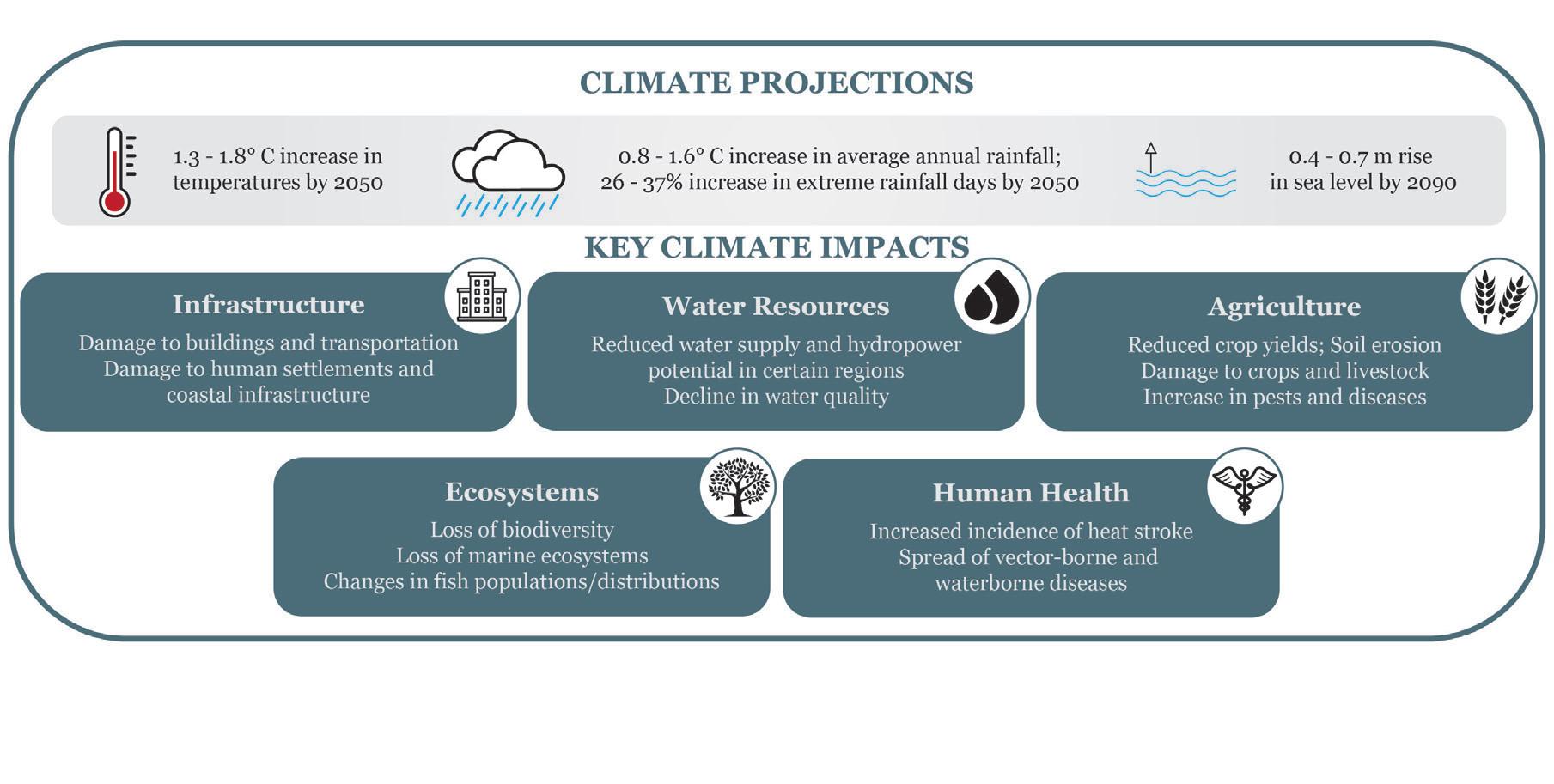
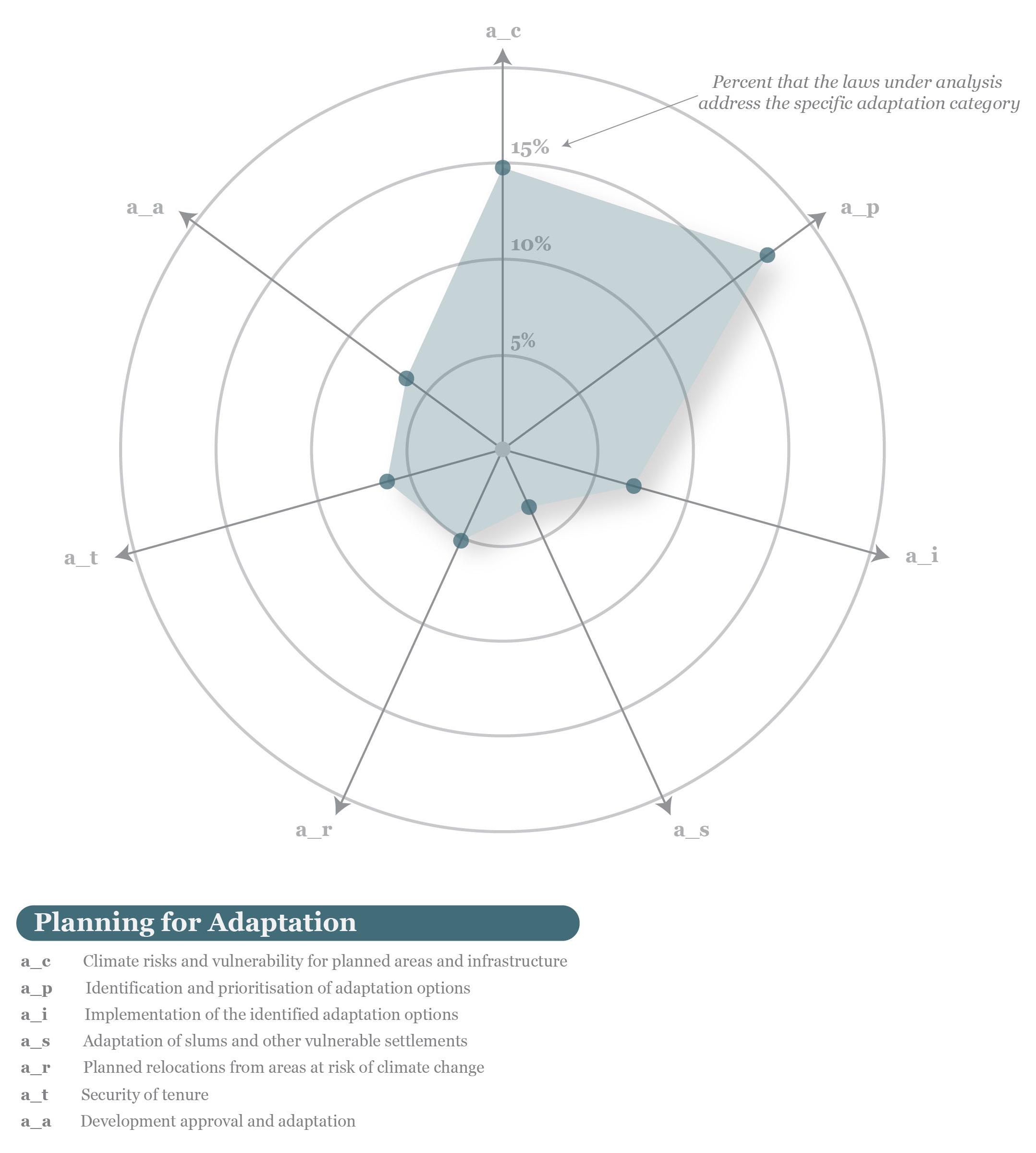
03 PLANNING FOR ADAPTATION
In the context of climate change adaptation, Colombia has a comprehensive body of territorial planning and environmental laws and policies that frequently acknowledge the need for climate risk and vulnerability assessments. The country has a national system for disaster risk management. At the national, regional and local levels, planning bodies have been identifying adaptation strategies and developing their own adaptation plans. The National Plan for Adaptation to Climate Change is an evolving policy that would benefit from mechanisms to prioritize and implement climate adaptation strategies. An additional key gap in the national legislation revolves around the housing sector, with the adaptation of slums and other vulnerable settlements to climate change seldom mentioned. While municipal Land Use Plans (POTs) define and regulate vulnerable housing settlements, there could be greater consistency in addressing these issues at the national level. It is essential to provide an overarching framework for additional resources, support, consultation, and considerations for adaptation to these already vulnerable populations and developments.
Climate change projections for Colombia create a variety of risks which include a 1.3 - 1.8°C increase in temperatures by 2050, a 0.8 - 1.6% increase in average annual rainfall by 2050, a 26 - 47% increase in extreme rainfall days by 2050, and a 0.4 - 0.7m rise in sea level by 2090.1 These climate hazards will have devastating consequences for
1 USAID, “Climate Risk Profile Colombia,” Climate Links, July 2017, https:// www.climatelinks.org/ sites/default/files/asset/ document/2017_USAID%20 CCIS_Climate%20Risk%20 Profile_Colombia.pdf.
2 USAID, “Climate Risk Profile Colombia.” the country. Many hazards, like flooding, landslides, and storms are already occurring. Specific impacts of climate change will affect key sectors in Colombia that include infrastructure, water resources, agriculture, ecosystems, and human health. The country can expect damage to buildings, transportation infrastructure, human settlements, and coastal infrastructure. In addition, there will be a reduced water supply and hydropower potential in certain regions as well as a decline in overall water quality. Agriculture will produce reduced crop yields while experiencing soil erosion. Crops and livestock will be affected by an increase in pests and diseases. Ecosystems will have a continued loss of biodiversity, marine ecosystems, and potentially devastating changes in the number and distribution of fish populations. Most importantly, human health will be impacted by an increased incidence of heat stroke and spread of vector-borne and waterborne diseases.2
Climate change can also exacerbate the difficulties faced by marginalized communities. According to the United Nations Sustainable Goal Indicators, nearly 28 percent of residents in the nation’s urban areas live in informal human settlements, or ‘slums’ comprised of structures that may lack adequate construction safety, basic infrastructure like water and sanitation access, and are likely more vulnerable to extreme weather events that will become more powerful and frequent with climate change like flooding.3 Indigenous peoples may become more susceptible to political and economic marginalization, loss of land and resources, human rights violations, and discrimination and unemployment. In Colombia, the area fully recognized for Afrodescendants and indigenous peoples as collective property covers over 37 million hectares, and almost 38 million with the inclusion of campesino reserves.
TABLE 1
Decree 1745 of 1995 discusses collective land titling for black communities was addressed as a strategy for the recognition
Mechanism of collective tenure and campesino reserve zones
Black communities Colonial resguardos Indigenous resguardos Established campesino reserve zones
Total Area (ha) Percentage of total national area
5,396,376 4.7
410,835
0.4 32,032,238 28.1 837,003 0,7
38,676,452 33.9
Source: prepared by the author on the basis of data from the Módulo de Información Geográfica sobre titulación colectiva formalizada y en trámite (OEC 2016) and the Instituto de Estudios Interculturales (2016).