
3 minute read
THE KINK IN THE NORTH FORK OF THE FORTYMILE RIVER


“Oblique photo looking north, channel that was blasted is in lower left quadrant. Entrance and exit of old river channel seen above and below a portion of ridge.” [USGS 1996]
The Kink in the North Fork
Advertisement
The Search for Gold Changed the Course of a River
The North Fork River is a major tributary of the Fortymile River in the eastern Interior of Alaska, flowing through the remote country north of the community of Chicken. Originally, the southeasterly path of the North Fork River was interrupted by a rock ridge 100 feet thick at the base and over 100 feet high. This rock ridge caused a two-and-three-quarter-mile oxbow meander to the west. In the U.S. Geological Survey Bulletin No. 2125, titled Gold Placers of the Historical Fortymile River Region, Alaska (USGS 1996), on page 21, is this description of a singular leftover from the gold rush era (note that dates differ in accounts):
“Approximately 20 miles up the North Fork from its confluence with the South Fork is a curious point on the map called The Kink. It is a very recently unnatural abandoned meander of the river. It was created in 1900 when an English-backed company blasted away a 100- foot-high bedrock ridge. The blast changed the course of the river and laid bare the 2 3/4- mile-long abandoned river bed meander. The original width of the cut-off was only about 16 feet, and at first only a small quantity of water flowed through it, but after a few hours the main body rushed through and soon worked out a channel over 39 feet wide (Prindle, 1905). The company had determined that the newly exposed gravels contained gold valued at approximately $9.00 per cubic yard so they were intent on mining them. In 1901 while an attempt was being made to mine the gravels with horses and scoops, a rock slide occurred that covered the gravels after which the company abandoned the area (Scott, 1990).”
The Kink was listed on the National Register of Historic Places in 1975. In the nomination for inclusion as a Historic Place, the history of the area was detailed:
“The Fortymile River Basin, located in the eastern Interior of Alaska has a rich gold mining history dating back to 1886. In that year, a man by the name of Franklin made the first significant discovery of gold on the South Fork of the Fortymile River, at a creek now named Franklin Gulch. This discovery triggered a minor stampede of prospectors into the Fortymile area. Even today gold mining remains a significant source of income to the area's inhabitants.
“The river channel which was bypassed in approximately 1904 by blasting through a rock ridge was suspected of containing very profitable amounts of gold. This proved false, however, after draining of the channel. When prospects showed no type of gold mining to be financially feasible, the site was abandoned.
“While appearing to be an easy task to complete with today's technology, The Kink was a major engineering feat in that time and place. It was accomplished in a relatively uncharted wilderness without benefit of machinery or any developed transporation or communication system. This area typically has harsh winters broken only by short, unpredictable summers. “When all other remnants, artifacts, and reminders of this colorful goldrush era of Alaskan history are gone, The Kink will remain. It serves as a permanent monument to the major undertakings by man thatwere common in the pursuit of gold at the turn of the century. “Today, The Kink retains the remoteness of that early era. It is 19 air miles from the nearest road and 82 air miles from the nearest settlement with communication capability. This segment of river has been proposed for inclusion in the National Wild and ScenicRivers System and receives significant use by canoe and rafting enthusiasts.” ~•~
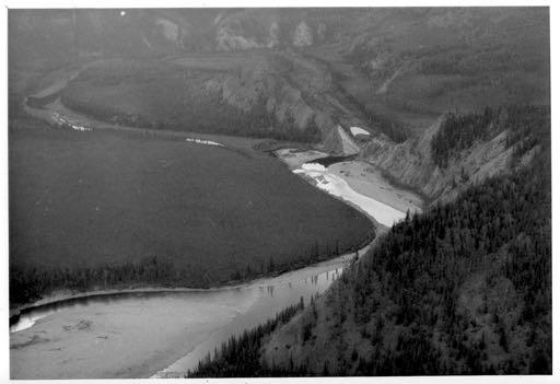
The Kink on the North Fork of the Fortymile River: “Oblique aerial looking west showing the artificial channel and the 2 3//4 mile meander that was bypassed.”
[USGS 1996]


