LAND FOR SALE
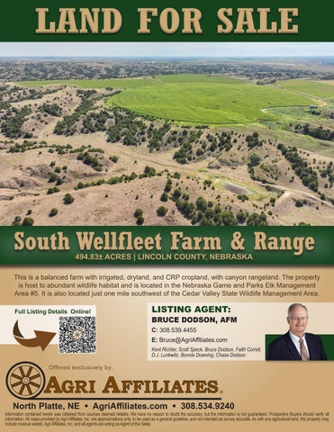
South Wellfleet Farm & Range 494.83± ACRES | LINCOLN COUNTY, NEBRASKA
This is a balanced farm with irrigated, dryland, and CRP cropland, with canyon rangeland. The property is host to abundant wildlife habitat and is located in the Nebraska Game and Parks Elk Management Area #5. It is also located just one mile southwest of the Cedar Valley State Wildlife Management Area. Full Listing Details Online!
LISTING AGENT:
BRUCE DODSON, AFM C: 308.539.4455 E: Bruce@AgriAffiliates.com Kent Richter, Scott Speck, Bruce Dodson, Faith Correll, D.J. Lunkwitz, Bonnie Downing, Chase Dodson
Offered exclusively by:
North Platte, NE • AgriAffiliates.com • 308.534.9240
Information contained herein was obtained from sources deemed reliable. We have no reason to doubt the accuracy, but the information is not guaranteed. Prospective Buyers should verify all information. All maps provided by Agri Affiliates, Inc. are approximations only, to be used as a general guideline, and not intended as survey accurate. As with any agricultural land, this property may include noxious weeds. Agri Affiliates, Inc. and all agents are acting as Agent of the Seller.
Location Map
Topog
Aerial Map
AERIAL MAP
TOPOGRAPHY MAP Topography Hillshade
Low
Elevation
High
Source
Interval(ft
Mi
Ma
Range
Average
Standard Deviation: Field borders provided by Farm Service Agency as of 5/21/2008.
Boundary Center: 40.707364, -100.725483
0ft
904ft
1808ft
Low
Elevation
High
Source: USGS 3 meter dem Interval(ft):
34-9N-30W Lincoln County Nebraska
0ft
826ft
34-9N-30W
Max: 2,994.0
AGRIAFFILIATES.COM
Lincoln County
Range: 188.3
Average: 2,899.6
9/24/2026
Standard Deviation:
1651ft
10
Min: 2,805.7
38.85 ft
9/24/2026
Nebraska
Boundary Center: 40.707364, -100.725483
Property Details LEGAL DESCRIPTION:
PT. W½E½, SE¼SE¼ & W½ EXCEPT 25.17 A. Section 34-T9N-R30 West the 6th P.M. in Lincoln County, Nebraska
LOCATION:
Located approximately 3 miles south of Wellfleet, NE, on Nile Rd.
ACRES &TAXES:
494.83 tax-assessed acres, less approximately 15 acres fenced-out in part of the W½NE¼ 2025 Real estate taxes due in 2026: $6,359.32
LAND USE:
233.00 acres 60.80 acres 49.40 acres 45.90 acres 37.25 acres 29.00 acres 17.05 acres 7.73 acres
LIVESTOCK WATER:
Provided by an electric pump-jack and 2 stock dams
EQUIPMENT:
(1) Reinke 6-tower center pivot, (1) 100 HP electric motor, (1) electric pump jack, stock tank, and all owned fences.
WELL REGISTRTION:
Well #: G-029983 Drilled June 6, 1968, 1,000 GPM, 192’ static, 235’ pumping
NRD:
Middle Republican Natural Resources District, 129.0 CIAs with 60 inches for the 2023 to 2027 allocation period (12 inches/year). At the end of the 2025 pumping season, there were 53 inches remaining.
PRICE:
$1,270,000.00
Range Pivot Irrigated Cropland Winter Range Gravity Irrigated Cropland CRP expiring 9/30/2030; annual payment $1,548 ($41.55/acre/year) Non-Irrigated Cropland Range Fenced Out Road/Waste
SOILS MAP Soils Map Soils Map
State: County: Location: Township: Acres: Date:
Soils data provided by USDA and NRCS.
Area Symbol: NE063, Soil Area Version: 23 Area Symbol: NE111, Soil Area Version: 24 Code
Soil Description
Soils data provided by USDA and NRCS.
Acres
2539 silt loams,Soil 3 to 60 percent slopes 23 AreaColyHobbs Symbol: NE063, Area Version:
171.40
2674
Holdrege silt loam, 1 to 3 percent slopes, plains
99.05
2529
Coly and Uly silt loams, 11 to 30 percent slopes
64.47
Area Symbol: NE111, Soil Area Version: 24 CodeandSoil Description breaks 2539
2676
2674
ColyHobbs silt loams, 3 to 60 percent slopes Holdrege silt loam, 3 to 7 percent slopes, eroded, plains and breaks
53.59
Holdrege silt loam, 1 to 3 percent slopes, plains Ulyand and Coly silt loams, 6 to 11 percent slopes, 40.71 breaks
Percent of field
NonIrr Class Legend
VIIe
20.9%
Acres
Percent of field
13.6%
171.40
IIIe
III
IV
13.6%
IVe
IV
11.3%
VIIe
2529 UlyColy Coly silt andloams, Uly silt loams, 11 to 30 percent slopes 6 to 11 percent slopes 31.26
64.47 6.6%
2560 siltloam, loams,33to to760percent percent slopes, slopes eroded, 12.67 2676 ColyUlyHobbs Holdrege silt
2.7% 53.59
plains and breaks
2809
Uly and Coly silt loams, 6 to 11 percent slopes,
40.71
II
Non *c
IVe
2832
eroded
VIe
36.3% 20.9%
8.6%
IIe
NonIrr Class Legend
11.3%
99.05
2809
NonIrr Class Irr Class *c *c
36.3%
Weighted Average
8.6%
eroded Class Dominant Condition Aggregation Method *c: Using Capabilities *- Irr Class weighted average cannot be calculated on the current soils data due to missing data.
4.91
Productive farm with grazing lands. Excellent wildlife habitat for elk, deer, turkey, and upland game birds. For more information, call Bruce Dodson at (308) 539-4455.
North Platte, NE • AgriAffiliates.com • 308.534.9240 •