4 minute read
Archives in Science: Using Colonial Records to Map Today’s Geological Risks

By Clare Kellar (Engagement Manager, AM)
Primary sources aren’t just reserved for the classrooms of history majors. Increasingly these materials are being used in cross-disciplinary areas including contemporary research having a direct impact on today’s public policy.
One example of this is the research field of Brian Atwater, U.S. Geological Survey and Affiliate Professor of Earth and Space Sciences at the University of Washington. He describes this research as “ trying to clarify earthquake and tsunami potential in the north-east Caribbean.” Working alongside colleagues from Canada, France, Germany, Puerto Rico, Pakistan, and the United States, he has been assessing the possible tsunami threat to Puerto Rico and the Virgin Islands from the Puerto Rico Trench.
To do this, he has been looking to use the history of the region as a natural warning system for coastal hazards.
Historical Investigation Alongside Scientific Research
As part of this important research, Professor Atwater accessed historical sources through AM’s Colonial Caribbean digital collection, delving into historical records for mentions of geological events in the region. Specifically, his research has focused on the potential impact of a pre-Columbian tsunami on Anegada in the British Virgin Islands. Highlighting the value of the historic materials, Professor Atwater described his work as “sleuthing a pre-Columbian tsunami with clues from Colonial Caribbean.”
Professor Atwater’s current work follows previous research he has undertaken both in Japan and on Indian Ocean shores following the disaster of December 2004. His approach to his research embodies the idea “that Earth history can overlap with human history, and it gets all the more interesting when it does,” both disciplines being interested in “the same issues of evidence, and why was something recorded.”
Professor Atwater’s recent work in this area bears out this interest in pursuing historical investigation alongside his scientific research.
There is a fascinating relationship between his study of the historical record in British Colonial Office documents of the nineteenth century, digitised in Colonial Caribbean, and his field research in Anegada, one of the British Virgin Islands, which, he discovered, has spectacular evidence for a catastrophic flood from the sea during the last centuries before Columbus.
“Access to the Colonial Office documents has helped figure out which boulders were moved by a Caribbean tsunami during the last centuries before Columbus.” — Professor Brian Atwater, University of Washington
The Value of Historical Sources
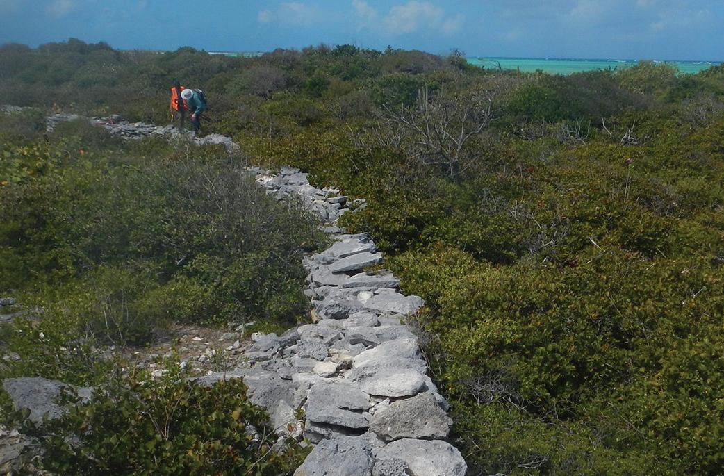
The value of the Colonial Office papers lies in helping to illuminate “ what transpired on Anegada that could affect the geological record of a pre-Columbian tsunami.” Professor Atwater’s intriguing findings have come to centre on limestone boulders and coral heads on the island that he believes to have been transported by a giant pre-Columbian wave, and then in some instances these have been used by islanders to form up to around 200 km of limestone walls.
Key documents to which Professor Atwater has had access through Colonial Caribbean include the work of an individual named Dr. John Stobo, whose estimates of land use on the island of Anegada include detailed tallies of acreage and productivity in 1815 and 1823. These offer clues on land modification and wall-building and are, according to Professor Atwater, “ the earliest things that we have that tell us that some large fraction of that island, Anegada, was devoted to pasture. That was very helpful to see that confirmed.”
Professor Atwater has looked further into the records relating to the colourful character of Stobo, investigating both his credibility and the accuracy and reliability of his statistics, while seeking additional information on when the walls were built and by whom.
In using historical sources to form a picture of limestone wall-building on the island in the late eighteenth and early nineteenth centuries, Professor Atwater is seeking to establish what this can reveal about the potential distribution of the boulders by a tsunami hundreds of years earlier; at the heart of his investigation is “ the problem that we had of distinguishing between boulders moved by water and boulders moved by people.”
The Past Isn’t Just History
Professor Atwater’s research into this region, combining scientific analysis with his study of human activity as revealed in the written historical record, continues. For the important story of tsunami activity of 600 years ago and what this might suggest for the future, the intricate record-keeping of the obscure figure of John Stobo has, perhaps surprisingly, come to play important part.
The work of Professor Atwater is just one illustration of the importance of the historical record alongside modern interpretation and investigation and the value of primary sources across disciplines continues to increase.
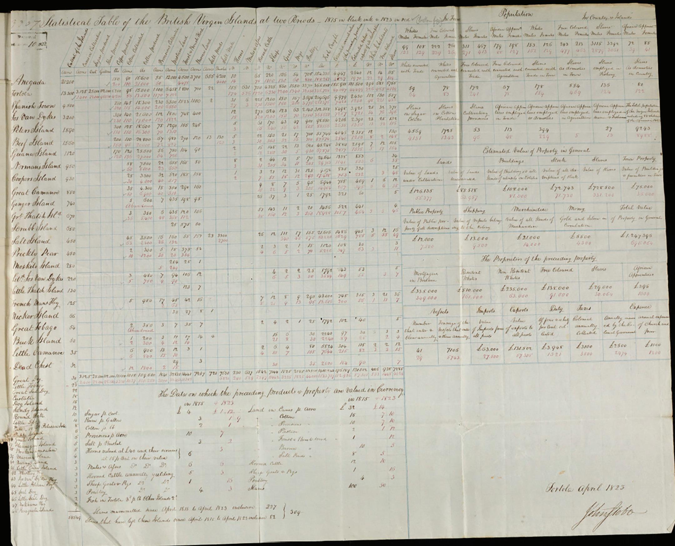
St Christophers, Nevis and the Virgin Islands, 1823, Despatches, Offices and Individuals.
Archives, UK. Further reproduction is prohibited without permission.