
21 minute read
Professional Contributions


The Cascade Volcanoes: Reaching New Heights in Applied Geoscience
Isaac E. Pope
Advertisement
Writing from western Washington,
Isaac Pope is a young undergraduate student with an insatiable fascination for geoscience. With publications in peer-reviewed journals, he has conducted much university-level research on both geological and mathematical topics. Mount St. Helens confirmed that the volcanic chain was an active and priceless opportunity (Driedger et al., 2020; Lipman and Mullineaux, 1981; Pope, 2020a). Fueled by its igneous processes and high-relief topography, the dynamic Cascadia landscape incites research within a number of fields of geoscience, of which physical volcanology is only the most obvious. Mass wasting, glacial fluctuations, and the resulting sedimentary deposits and fluvial environments generated by the volcanic setting meld to form an evolving landscape, which has been studied during both the episodes of quiescence and the interims of relative hyperactivity. Furthermore, the volcanogenic geology duced the local bedrock have continued into the present. This allows for a more complete understanding of the local geologic history and common natural hazards. Even after decades of study, continued research of such a unique laboratory can be applied to a host of practical and engineering problems prevalent in a variety of geologic environments (Pope, 2020b; Pope, 2020d).
owering along the Cascade Magmatic Arc from California to British Columbia, the Cascade Volcanoes are a series of Quaternary stratovolcanoes attesting to the long geologic history of that dynamic landscape. A mere continuation of arc volcanism since the Eocene (Armentrout, 1987), the Cascade Volcanoes have continued to drive geologic investigation four decades after the May 18, 1980, eruption of T Numbering nearly thirty prominent cones from Lassen Peak in California to Mount Meager in British Columbia, the Cascade Volcanoes are series of Quaternary stratocones along the Cascade Magmatic Arc surrounded by a number of smaller cinder cones and other volcanics (figure 1). With diverse geologic histories, the Cascade stratocone eruptions have ranged from dacitic tephra eruptions and dome building, such as at Mount St. Helens, and andesitic and basalt flows with little tephra, such as at Mount Adams, which form the bulk of
Physical Volcanology: Laying the Foundation
adjoining the Cascade Volcanoes makes the area one of the only locales Figure 1. Numbering to nearly thirty peaks, the Cascade Volcanoes are a series of Quaternary composite cones along the Cascade Magmatic Arc from California to British Columbia. Seven volcanoes (pictured) have erupted in the past three hundred years, yet this volcanism is merely a continuation of activity since the Eocene. Both the high-relief topography along the arc and the volcanic energy expelled during these eruptions fuel several fields of geologic investigation, thereby where processes that pro- providing an unparalleled opportunity to advance applied geoscience. Images in the public domain on the USGS website.
Cascade volcanism (Hildreth, 2007). Although a continuation of such Cascadia igneous activity since its commencement in the Eocene (Armentrout, 1987), the Cascade Volcanoes have yielded several eruptions in the past two-hundred years (figure 1), making this the most active volcanic chain in the contiguous United States. The volcanic energy coupled with the high-relief topography produces a dynamic environment that provides an unparalleled opportunity to observe volcanic processes in the present as they had existed while producing the basement rock and sculpting the surrounding regions, thereby allowing us to identify potential hazards in both volcanic and non-volcanic environments.
Glaciology: Tracking Climate and Volcanism
Hosting a number of glaciers upon their slopes, the thirty Cascade stratocones contain records of past glaciations and resulting transformation through time in response to climate and volcanism (figure 2). From geologic deposits and photographic records of the past century, climate-induced glacier dynamics can be studied during both the previous surges and current recession, thereby providing the opportunity to study current glacial dynamics and hazards and compare them with older sites to determine their geologic history and to identify potential engineering challenges with respect to aging deposits.
Glacial studies are not limited to the current century either. The age of Cascades makes it possible to investigate most, if not all, of the Pleistocene glaciations. Some, such as the Goat Rocks Volcanic Complex, have been heavily glaciated into the Pliocene (Hildreth, 2007), preserving a record of many of the Quaternary glaciations in the Western United States.
Mass Wasting: Bringing Hill to Valley
In the dynamic high-relief landscape of Cascadia, mass wasting is exemplified in a variety of forms both near and distant from the volcanic cones, which may be triggered by volcanism, seismicity, or simple responses to the humid Mediterranean climate. As in many regions beyond Cascadia, rock fall, slumping, and other forms of mass wasting provide a continual engineering challenge, but landslides are particularly significant contributors to Initiated by a shallow 5.1 magnitude earthquake, the sliding of 2.8 cubic kilometers of volcanogenic material into the North Fork Toutle River valley, the largest landslide in recorded history, commenced the May 18, 1980 eruption of Mount St. Helens and removed over 300 meters of elevation from the summit (Glicken, 1996). The identification of the resulting hummocks in the landslide led to the realization that similar hummocks at Mount Shasta had also been formed during a landslide (figure 3) (Crandell et al., 1984; Crandell, 1989). While Mount St. Helens’ initial landslide was produced by harmonic tremors as magma was ascending into the cone, Mount St. Helens is not the only example of landslides during volcanic eruptions. The more than 3.8-cubic-km Osceola Mudflow was initiated by the collapse of the Mount Rainier peak during a phreatomagmatic eruption (approximately 5.6 ka), which later transformed into a volcanic mudflow through White River into the Puget Lowlands (Vallance and

mass wasting around the Cascade Volcanoes. Scott, 1997), creating Mount Rainier’s iconic crater.
Figure 2. The lofty Cascade peaks host a number of glaciers useful for tracking both climate and volcanism. A. Glacier Peak in northern Washington is one of several Cascade Volcanoes recording both past and current glaciations with a variety of prominent glacial features, while some volcanics (such as Goat Rocks Volcanic Complex) are old enough to contain remnants of glaciations into the Pliocene. Image in the public domain on the USGS website. B. Among others at Mount Rainier, the Nisqually Glacier and its dynamics has been documented for tracking current climate change, but glacial deposits such as the lateral moraine in the foreground can provide clues into the Mediaeval “Little Ice Age” and other recent climate fluctuations.
Figure 3. In the high-relief topography of the Cascade Magmatic Arc, mass wasting is a crucial facet of Cascadia geology resulting from both volcanic and nonvolcanic stimuli. After the May 18 eruption of Mount St. Helens and associated landslide in 1980, geologists realized that the hillocks stretching over forty kilometers from Mount Shasta resulted from a landslide that swept across the valley and produced hummocky topography. Light-colored structures along roadways barely visible in this image indicate the enormous size of the hummocks. Image in the public domain on the USGS website.

Fluvial Geomorphology: Reading the Rivers
The various natural hazards caused by the Cascade Volcanoes produces a host of factors influencing fluvial geomorphology of nearby valleys, leading to complex geomorphological evolution of the landscape. As documented at Mount St. Helens, landslides can contribute voluminous material to river valleys and dam lakes, increasing the sediment load in rivers and making the potential for extreme flooding whenever a lake overflows or breaches its dam. Reaching further afield than landslides, lahars (volcanic mudflows) can be formed from rapid melting of glaciers during volcanic eruptions. Alternatively, some lahars may also be produced by collapse of a rock avalanche that mixed with snow and ice, such as the Trout Lake Lahar that extended from the southern flanks of Mount Adams to the Columbia River along the present Washington/Oregon boundary. Although only Holocene rock-avalanche lahars (Vallance, 1999) and perhaps one late-glacial lahar (Pope, 2020c) have been identified at Mount Adams, the Quaternary history of lahars has been well studied at Mount St. Helens (Clynne et al., 2008; Crandell and Mullineaux, 1978; Mullineaux and Crandell, 1962), Mount Rainier (Zehfuss et al., 2003), Mount Baker in northern Washington (Tucker et al., 2007; Tucker et al., 2014), and Mount Hood in northern Oregon (Pierson et al., 2009), among others.
Even without volcanic activity, hyperconcentrated flows may be induced by the rapid release of water stored in a glacier, genetically referred to as a jökulhlaup, which can travel many kilometers from the volcano (figure 4). Because of their higher frequency than lahars, jökulhlaups can be important influences on a fluvial system by rerouting streams, toppling trees, and depositing and incising coarse sediments. Regardless of origin, the hyperconcentrated flows of the Cascade Volcanoes provide a unique opportunity to study these natural hazards to better understand debris flows in a variety of environments.
Sedimentology: Uncovering the Record
As noted by Heim (1990), geoscience professionals are “truly handicapped” if they lack an understanding of an area’s geologic history in which they are working. USGS geologists saw this firsthand while advising the evacuation of a US military base in the Philippines built in a valley prone to pyroclastic flows from Mount Pinatubo. If the geologists had not recognized that the deposits within the valley were similar to pyroclastics at Mount St. Helens, thousands of lives may have been lost during the 1990 eruption of Mount Pinatubo (Thompson, 2000). Lessons from Mount St. Helens in 1980, Mount Pinatubo in 1990, and others across the globe crystallized the need to understand the geologic history of an area. Indeed, how may one predict the geologic hazards of a site without first considering what has happened in its past?
With the multitude of geologic conditions and hazards fueled by the Cascade Volcanoes, a variety of sedimentary environments comparable to those in non-volcanic settings can be studied, sometimes with surprising results. For example, fine lamination can be produced within minutes during jökulhlaups (figure 5), which most geologists would not expect in high-energy regimes (Leclair and Arnott, 2005). Misidentifying such laminations may lead to an underappreciation of the natural hazards––a possibility highlighting our need to study sedimentary environments in real time and apply that knowledge to our engineering projects.
Hydrogeology: Mitigating the Poison
The geology of the Cascade Volcanoes is truly intricate. Built on the faulted and deformed foundation of predecessor volcanics, the lavas and volcaniclastics of the Cascade stratocones provide a distinctive hydrogeological experiment. Water
Figure 4. In such a dynamic environment, fluvial geomorphological evolution may proceed through a host of factors operating at various rates. This transformation occurs through either volcanic activity (such as lahars) or in the interludes between eruptions, but not all accelerated alterations are induced through volcanism. Glacial outburst floods, or jökulhlaups, occasionally inundate stream valleys carrying glacial meltwater, as can be seen on Tahoma Creek only a month after a jökulhlaup from Nisqually Glacier. Notice the snags denoting the extent of the jökulhlaup beyond the stream’s previous channel.

percolating through the Miocene fold system and overlying volcanics or even near-surface water seepage through debris flow deposits all pose unique conditions for studying how water is stored in and flows between complex systems. Ascending magma and volcanic eruptions can infiltrate the groundwater with hazardous chemicals which may then be transferred into rivers or delicate ecosystems, as observed at Mount St. Helens (Bonelli et al., 1982). Studies mitigating the hazards in communities near volcanoes can provide further insight into dealing with hazardous waste management in complex geologic settings elsewhere. The fractured and faulted bedrock also encourages fracture permeability, the subject of a number of recent studies.
A
B
Conclusions
Four decades after Mount St. Helens revived interest in Cascadia, the Quaternary Cascade Volcanoes and surrounding areas continue to offer a myriad of opportunities for advancing applied geoscience. Physical volcanology, though the most obvious discipline, is the driving force fueling a number of geologic processes and hazards that are analogous to those in numerous non-volcanic settings (figure 6). The high elevation
C

Figure 5. Geoscientists would be greatly impeded without first considering a site’s geologic history. To better understand and predict natural hazards common at sites in a variety of environments, the Cascade Volcanoes provide opportunities to study a myriad of sedimentary environments in real time, occasionally yielding surprising results. A. Laminated sands and silts resulting from the latter stages of a jökulhlaup on August 17, 2019, which flooded Tahoma Creek from Nisqually Glacier on Mount Rainier. B. and C. Trough-like cross- laminations interstitial boulders from the 17 August 2019 jökulhlaup on the Tahoma Creek, which may contain striking bands of clay cross-laminations (denoted by the arrow in C).
Figure 6. In the dynamic environment surrounding the Cascade Volcanoes, several disciplines of applied geoscience are represented and encapsulated within the post-1980 landscape of Mount St. Helens. Only the most evident, physical volcanology along with the high-relief topography drives the other disciplines, such as glaciology. Mass wasting, as represented by the primary 18 May 1980 landslide, fluvial geomorphology, as illustrated by the North Fork Toutle River canyon system, and sedimentology, shown by tephra deposits, can be studied to predict and mitigate a variety of natural hazards in both volcanic and non-volcanic environments across the globe, while the resulting complex systems and volcanogenic pollutants simulates a hydrogeological experiment. With so many fields represented, the Cascade Volcanoes are truly exemplary laboratories!

and age of the stratocones allow glacial geologists to study current glacial dynamics in response to volcanism and climate, which may be compared to the record of Pleistocene and even Pliocene glacial deposits among the Cascade Volcanoes. Mass wasting of the high-relief topography aided by volcanism and the Mediterranean climate provide case studies for a variety of mass displacement and movement processes, while the lahars and jökulhlaups combine with mass wasting to incite evolution of the fluvial geomorphology. The resulting deposits from these varied sedimentary environments encourages research of sedimentation in real time, which may be extended to predicting natural hazards at engineering sites. Amid this intricate landscape, hydrogeology may be advanced through study of hazardous chemicals being transferred through complex systems. Representing so many disciplines, the Cascade Volcanoes are an exemplary laboratory for advancing applied geoscience. The opportunity to reach new heights has never been more exciting!
Acknowledgments
I thank Dr. Scott Burns for his thoughtful review of this article as well as Mr. John Berry and Dr. George Mustoe for their constructive comments on my original abstract (Pope, 2020d), which formed the basis for this article.
References
Armentrout, J.M, 1987, Cenozoic sequence stratigraphy, unconformity-bounded sequences, and tectonic history of southwest Washington, in Schuster, J.E., ed., Selected papers on the geology of Washington: Washington Division of Geology and Earth Resources Bulletin, v. 77, p. 291–320. Bonelli, J.E., Taylor, H.E., and Klein, J.M., 1982., Impact of Mount St. Helens eruption on hydrology and water quality: US Geologic Survey Technical Report N-8311538, pp. 261–264. Clynne, M.A., Calvert, A.T., Wolfe, E.W., Evarts, R.C., Fleck, R.J., and Lanphere, M.A., 2008., The Pleistocene eruptive history of Mount St. Helens, Washington, from 300,000 to 12,800 Years Before Present, in Sherrod, D.R., Scott, W.E., and Stauffer, P.H., eds., 2008, A volcano rekindled: the renewed eruption of Mount St. Helens, 2004-2006: U.S. Geological Survey Professional Paper 1750, p. 593–627. Crandell, D.R., 1989, Gigantic debris avalanche of Pleistocene age from ancestral Mount Shasta volcano, California, and debris-avalanche hazard zonation: US Geological Survey Bulletin 1861. Crandell, D.R., and Mullineaux, D.R, 1978, Potential hazards from future eruptions of Mount St. Helens volcano, Washington: U.S. Geological Survey Bulletin 1383- C. Crandell, D.R., Miller, C.D., Glicken, H.X., Christiansen, R.L., and Newhall, C.G., 1984, Catastrophic debris avalanche from ancestral Mount Shasta volcano, California. Geology, v. 12, p. 143–146. Driedger, C.L., Major, J.J., Pallister, J.S., Clynne, M.A., Moran, S.C., Westby, E.G., and Ewert, J.W., 2020, Ten ways Mount St. Helens changed our world—The enduring legacy of the 1980 eruption: U.S. Geological Survey Fact Sheet 2020-3031, 6 p. [https://doi.org/10.3133/fs20203031]. Glicken, H., 1996, Rockslide-debris avalanche of May 18, 1980, Mount St. Helens Volcano, Washington: U.S. Geological Survey Open-File Report 96 -677.

Heim, G.E., 1990, Knowledge of the origin of soil Deposits is of primary Pope, I.E., 2020c., Poorly sorted terrace deposits of the Cispus valley: Glacial importance to understanding the nature of the deposit: Bulletin of the drift or Mount Adams lahar? Association of Environmental & Engineering Association of Engineering Geologists, v. 17, n. 1, p. 109–112. Geologists 2020 Virtual Annual Meeting. [Poster]. Hildreth, W., 2007, Quaternary magmatism in the Cascades – Geologic Pope, I.E., 2020d, Reaching new heights: The Cascade Volcanoes as exemplary Perspectives: US Geological Survey Professional Paper 1744, doi: laboratories for applied geoscience: Association of Environmental and 10.3133/pp1744.s. Engineering Geologists 2020 Virtual Annual Meeting. Leclair, S. and Arnott, R., 2005, Parallel lamination formed by high-density Thompson, D., 2000, Volcano cowboys: The rocky evolution of a dangerous turbidity currents: Journal of Sedimentary Research, v. 75, n. 1, p. 1–5. science: Thomas Dunne Books, New York, NY, 326 p. Lipman, P., and Mullineaux, D., eds., 1981., The 1980 eruption of Mount St. Tucker, D.S., Scott, K.M., and Lewis, D.R., 2007, Field guide to Mount Baker Helens, Washington: Early results of studies of volcanic events in 1980, volcanic deposits in the Baker River valley: Nineteenth century lahars, geophysical monitoring of activity, and studies of volcanic deposits, tephras, debris avalanches, and early Holocene subaqueous lava, in effects, and potential hazards: US Geological Survey Professional Paper Stelling, P., and Tucker, D.S., eds., Floods, faults, and fire: Geological field 1250. trips in Washington State and southwest British Columbia: Geological Mullineaux, D.R. and Crandell, D.R., 1962, Recent lahars from Mount St. Helens, Society of America Field Guide 9, p. 83–98, doi: 10.1130/2007.fld009(04). Washington: Geological Society of America Bulletin v. 73, n. 7, p. 855 – Tucker, D.S., Scott, K.M., Grossman, E.E., and Linneman, S., 2014, Mount 870, doi: 10.1130/0016-7606. Baker lahars and debris flows, ancient, modern, and future, in Dashtgard, Pierson, T.C., Scott, W.E., Vallance, J.W., and Pringle, P.T., 2009, Eruptionrelated lahars and sedimentation response downstream of Mount Hood: Field guide to volcaniclastic deposits along the Sandy River, Oregon, in S., and Ward, B., eds., Trials and tribulations of life on an active subduction zone: Field trips in and around Vancouver, Canada: Geological Society of America Field Guide 38, p. 33–52, doi: 10.1130/2014.0038(03). O’Connor, J.E., Dorsey, R.J., and Madin, I.P., eds., Volcanoes to Vineyards: Vallance, J.W. and Scott, K.M., 1997, The Osceola Mudflow from Mount Rainier: Geologic field trips through the dynamic landscape of the Pacific North- Sedimentology and hazard implications of a huge clay-rich debris flow: GSA west: Geological Society of America Field Guide 15, p. 221–236, doi: Bulletin, v. 109, n. 2, p. 143–163. 10.1130/2009.fld015(11). Vallance, J.W., 1999, Postglacial lahars and potential hazards in the White Pope, I.E., 2020a, David A. Johnston (1949-1980): Luminary of volcanology and Salmon River system on the southwest flank of Mount Adams, Washington: martyr for science: The Professional Geologist, v. 57, n. 2, p. 50–54. US Geological Survey Bulletin 2161, doi: 10.3133/b2161. Pope, I.E., 2020b., Mount Rainier (Washington): a volcanic landscape over- Zehfuss, P.H., Atwater, B.F., Vallance, J.W., Brenniman, H., and Brown, T.A., flowing with geomorphological wonders! The Professional Geologist, v. 57, 2003, Holocene lahars and their by-products along the historical path of n. 1, p. 51–53. the White River between Mount Rainier and Seattle, in Swanson, T.W., ed., Western Cordillera and adjacent areas: Boulder, Colorado, Geological Society of America Field Guide 4, p. 209–223.
…for These Future AEG EventsSave the Dates
AEG 2022 Annual Meeting Willamette rivers, in the shadow of snowcapped Mount Hood. Planet Hollywood Resort – Las Vegas, Nevada It’s known for its parks, bridges, and bicycle paths, as well as for its ecoSeptember 13–17 friendliness and its microbreweries and coffeehouses. The city hosts thriving
Your fun begins on The Strip, Las Vegas’ main artery and home to art, theater, and bustling casinos, world-class restaurants, ornately designed resorts music scenes. Surrounded by Portland hot spots, the Marriott and over-the-top shows. Overlooking the Las Vegas Strip, our Portland Downtown Waterfront hotel reflects the vibrancy of the city
Annual Meeting hotel—Planet Hollywood Resort—is in the middle and is located directly on the waterfront in downtown, surrounded by of everything you will want to experience. This Annual Meeting will be exciting, educational, and a great opportunity to reconnect with your colleagues and meet new ones. more than 60 breweries. Wind down with friends by sampling some of the 150 types of whiskey at their on-site restaurant, Proof Reader. The hotel even helps you go green with complimentary car-charging
AEG 2023 Annual Meeting stations, biodegradable straws and easy access to light rail from the nearby Morrison Subway Station. At night, retire to elevated guest
Portland Marriott Downtown Waterfront – Portland, Oregon rooms with 24-hour room service, waterfall showers, free Wi-Fi, premium channels and views of Portland. Don’t miss all of the exciting Field Courses, Guest Tours and the Special Event at the
September 19–24 Oswago Hills Vineyard planned for this incredible Annual Meeting.
The In-Person AEG 2020 Annual Meeting has been rescheduled for 2023. Portland, Oregon’s largest city, sits on the Columbia and

Dam Failure: Edenville and Sanford Dams
Thomas Oommen1, Colin Brooks2 Rick Dobson2, & Nick Marion2
Thomas Oommen is a Professor in the Geological and Mining Engineering and Sciences Department and the Director of the Computational Science and Engineering PhD Program at Michigan Technological University.
After heavy rainfall, Edenville Dam in Michigan failed on Tuesday, May 19, 2020, and Sanford Dam failed downstream the next day. The National
Weather Service (NWS) reported that the Midland area received 4.13 inches of rain from May 17–19. The dam failures prompted the evacuation of over 10,000 residents. A slope failure led to the collapse of Edenville dam, and the quick-release of water from the failed Edenville Dam led to the overtopping and failure of the Sanford Dam situated 10-mile downstream. Following the dam failures, a Michigan Technological University (MTU) team, including the Michigan Tech
Research Institute (MTRI), carried out a reconnaissance survey. The MTU team captured images of the dam failures from Unmanned Aerial Vehicles (UAVs) and developed 3D models of flooding-impacted sites using Structure-from-Motion (SfM) photogrammetry. The images were collected using DJI Mavic, Mavic 2 Pro, & Phantom 3 Advanced UAVs with ground control points whose positions were recorded with decimeter accuracy GPS (figure 1).
The stereo overlapping images were used to develop 3D models using SfM photogrammetry with the Agisoft Metashape software. The scaled and georeferenced outputs developed from the UAV survey include orthophoto, Digital Elevation Model (DEM), and DEM-based derivatives. A comparison of the prefailure dam profile with the post-failure imagery and DEM is shown in Figures 2 & 3. The elevation profile from the postfailure DEM indicates approximately 10 meters of scour at the Edenville Dam site.
Along with the failure of Edenville Dam, the bridge carrying North Meridian Road (M-30) over Wixom Lake washed out due to the rapid draining of the lake that had been impounded by the Edenville Dam. The bridge is located to the west and upstream of the Edenville Dam failure site. Figure 4 shows the extent of the bridge washout caused by the rapid lowering of the lake level. The bridge span was 7.9 meters prior to the failure, and a 70.1-meter section of roadway (including the former bridge) was washed out.


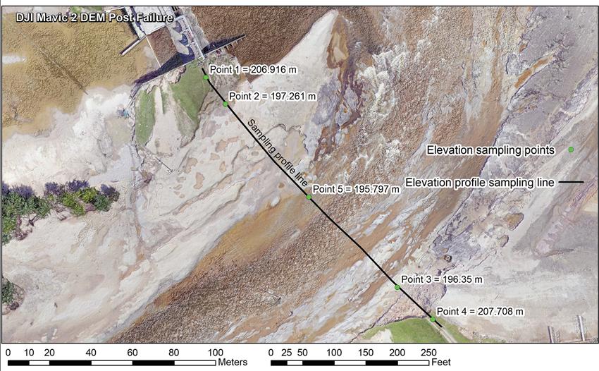
Figure 2: Comparison of the pre- and post-event imagery and DEM at the Edenville Dam site.
Sanford Dam, located 10 miles downstream of Edenville Dam, experienced an overtopping failure. A comparison of the pre-failure dam profile with post-failure imagery and DEM is shown in Figure 5. The profile indicates that the Sanford Dam failure site experienced more than 20 meters of scouring. Based on the Michigan Department of Natural Resources (DNR) regional geologic map, the Midland area was covered by Glacial Lake Saginaw Lake about 13,000 years ago, and lacustrine sand, gravel, and clay were deposited during this time (Milstein, 1987). The bedrock is mapped as Pennsylvanian Age Grand River Formation (sandstone) and older Saginaw Formation, which are composed of interbedded sandstone, shale, shaley limestone, and coal. No exposed bedrock was observed at the site, and the material observed was mostly sand, gravel, and clay.
Using existing 1-meter resolution light detection and ranging (lidar) data available from the US Geological Survey collected in 2016, and comparing the lidar surface to the new 3D UAS data, the MTU team was able to estimate volumes of dam material that were lost due to the failure events. The MTU team estimated material losses of approximately 63,590 m3 at Edenville Dam and
Figure 3: Post-failure elevation profile obtained at Edenville Dam overlaid on the orthophoto.
Figure 4: Comparison of M-30 bridge over Wixom Lake before and after the Edenville Dam failure. Figure 5: Comparison of the pre- and post-event imagery and DEM at the Sanford Dam site.


Figure 6: Comparison of pre-failure lidar elevation data to post-failure UAS SfM-derived elevation data used to calculate volumes of dam material lost due to their failures. approximately 350,769 m3 at Sanford Dam. Figure 6 shows the area used to calculate these volumes for the two dam locations, the pre-failure lidar-based elevation data, and the post-failure UAV SfM elevation data.

References
Milstein, R. L., 1987, Bedrock geology of southern Michigan: Michigan DNR Geological Survey Division, scale 1:500,000.
Author Info
1. Department of Geological and Mining Engineering and Sciences, Michigan Technological University, Houghton, MI-49931 2. Michigan Tech Research Institute, Ann Arbor, Michigan, USA.

