2 minute read
GIS Department


Staff; Avis Deneault and Brandon Belcher Overview
Projects involved in this year:
Advertisement
ALIB Forestry Development; operational mapping (Recce, Site Plan, Cruise, Appraisal Maps), data management, track our data and update government with data using Phoenix Pro.
ALIB Silviculture Programs; use our system to report data/spatial data to government (ensure we meet our obligations), data management (track our data and update government using Phoenix Pro), planting mapping, survey mapping.

Verifying Civic Addresses for ALIB reserve parcels; this will be brought forward to emergency services; they will then be able to serve communities efficiently.
Support ALIB departments and community mapping, overlay, banners/poster printing/design, data management, parcel mapping, land management mapping, hunting camp direction map.
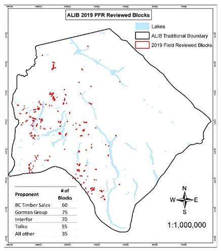
GIS Technician – Forestry Referrals Avis Deneault, Jen Pooley, and Celia Nord The field season for PFR’s was from May through to the beginning of November.
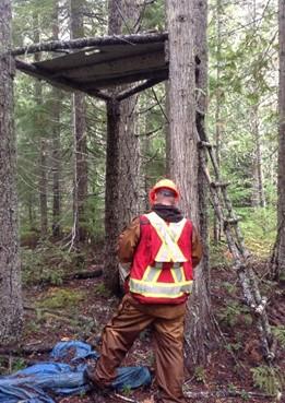
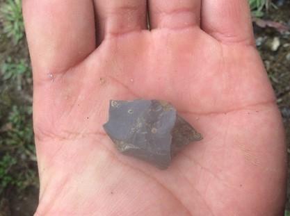
There were approximately 300 blocks assessed this year for roughly 10 different proponents throughout the season. The crews found archaeological and/or cultural heritage concerns within 32 of these blocks and recommended a second opinion. Some of the features recommended this year include debitage/flakes, possible CMT’s (culturally modified trees), possible traditional trails and potential traditional overnight areas. (See pictures). Other nonarchaeological/cultural features are often observed also (see the tree stand below).
Recreation Site Maintenance
Employees: Gary Michel and Karen August. We have a co-management agreement with Recreations Site and Trails BC to manage and maintain the recreation sites around Adams Lake including Dennis Lake, Johnson Lake, Skmana Lake, Squaam Bay, Gannet Lake, Gordon Bay, Honeymoon Bay, Rocky Point, Stukemapten Lake, Tsikwustum Creek North & South.
(See map Rec Site map created by Avis)
Brennon Creek Site is closed indefinitely due to the land sliding down the mountains.
Staff: Brennan Lund, Adams Lake Fisheries Communication and Management
This program allows for consultation with the general membership on fisheries policy and planning issues; This also includes reviewing local conservation concerns, facilitating development of fishing plans, issuing permits, organizing communal fishing events, and arranging enforcement protocol discussions with DFO; and coordinate annual salmon ceremony and organize the canning of salmon
Adams Lake Catch Surveying:
Catch Survey is the bands community fisheries program. We use the boat to set nets and catch salmon to bring to the fish cleaning station for processing. Due to Covid things were run differently this year with the Salmon handed out directly to the community members and the rest processed and delivered to the community freezer. This year we caught, shared, and stored over 780 salmon.
The purpose of the project is to conduct Coho assessments on the tributaries of Adams Lake. The enumeration method consists of stream walk surveys at set intervals and within set stream sections during the period of adult Coho presence within the tributaries. Data collection standards have been set by local DFO Stock Assessment Division. Data collected from these surveys will be used by SFC, the Secwepemc communities and DFO Stock Assessment to estimate Coho escapements.
NR employees conduct Coho Stream assessments on the following creeks (tributaries): Sinmax, Huihill, Nikwikwaia, Harbour, Cayenne and Momich River.
Adams Lake Creel Survey:

NR Employees conduct patrols of the South Thompson River, Adams Lake Bridge, Hoffman’s Bluff, Pritchard Bridge, and interview sport fisherman for the purpose of collecting harvest information such as type of gear used, length of time spent fishing, species caught and released, hourly levels of gear type (fishing activity), biological sampling, relay of fishing opening or closure information and reporting of illegal fishing activities.
Other Fisheries
Adams Lake implemented year one of a 4-year program to fertilize the upper Adams Lake with the goal of replicating what used to happen when millions of Salmon returned to the Adams Lake system to see the return of these runs. This project consists of environmental monitoring such as limnology, C14 sampling, Smolt sampling, perch monitoring and bull trout monitoring to make sure no further harm is done as the fertilizer is applied.
This year was the first year of three where Fertilizer was applied to mimic the millions of salmon that used to return to Adams Lake.


