SubTel Forum Issue #4 - Future Trends and Innovations in Submarine Telecoms
An international forum for the expression of ideas and opinions pertaining to the submarine telecom industry
Submarine Telecoms Forum is published quarterly by WFN Strategies, L.L.C. The publication may not be reproduced or transmitted in any form, in whole or in part, without the permission of the publishers. Liability: while every care is taken in preparation of this publication, the publishers cannot be held responsible for the accuracy of the information herein, or any errors which may occur in advertising or editorial content, or any consequence arising from any errors or omissions.
Submarine Telecoms Forum is an independent commercial publication, serving as a freely accessible forum for professionals in industries connected with submarine optical fibre technologies and techniques. The publisher cannot be held responsible for any views expressed by contributors, and the editor reserves the right to edit any advertising or editorial material submitted for publication.
Contributions are welcomed and should be forwarded to the Managing Editor: Wayne F. Nielsen, WFN Strategies, 115 Environs Road, Sterling, Virginia 20165, USA. Tel: +1 (703) 444-2527, Fax:+1 (703) 444-3047. Email: editor@subtelforum.com.
Designed and produced by Ted Breeze BJ Marketing Communications, Colchester, UK..
Welcome to the 4th edition of Submarine Telecoms Forum, and indeed the culmination of the end of our 1st year for the magazine.
To say the last 12 months have been interesting would be somewhat of an understatement. However, in spite of what seems to be daily occurrences of bad news, we press on, not because we are masochistic, but instead because we believe that in spite of itself, there will still exist a submarine telecoms industry at the end of the day. And so, like others, we press on.
This issue contains some excellent insight from folks far smarter then me.
Various articles explore the forces impacting bandwidth demand and pricing, implications of voluntary reorganization, as well as new, leading technologies that are only now beginning to come into vogue. Bob Stuart of InDepth provides a second installment of his analysis of the financial markets impact on Telecoms, and Jean Devos returns with his ever insightful look at the world. Of course, our ever popular “where in the world are all those pesky cableships” is included as well.
For those friends in the South, may it be an easy winter; and for those in the North, wishing you a pleasant, fruitful summer.
Wayne F Nielsen Publisher
Emails to the Editor
Dear Sir,
While I am sure that Bob Stuart never intended to be plagiaristic, I am flattered that he should choose the same title for his article as the one which I wrote for “Soundings” magazine, published in January this year.
I am still more flattered that he shares my view that the Finance Community bears a heavy responsibility for what has happened to the Submarine Cable Industry. Will equity investors return to the Submarine Cable Market ? Probably,
Yes, but it’s the lights of the “Fire Sale Express” coming in the other direction!
I always enjoy reading the magazine, and I appreciate the electronic format.
Hugh South
The Johns Hopkins University Applied Physics Laboratory when the immediate capacity overhang on major routes is consumed. Will they be building global networks ? Probably not : there is regional in-fill required with more attractive margins, leaving the “big plays” to the PTT-dominated consortia. Can we see light at the end of the tunnel?
A deadline-free lunch gave me the freedom to flick the latest edition of SubTel Forum. Just thought that I would relay back to you that my flicking led to a full reading of most of the contents of the Forum and that I found many of the articles fascinating and thought provoking. It is so interesting to read such a diversity of views on a common subject in such a short space of time and relating them to backgrounds of the authors and their affiliations. The contents of some of the papers set me thinking about the opportunities that may exist when the industry does rear its head again in 2002 . . 2003 . . 2004 . . whichever author you believe.
Mick Cook, Director, Hydrosearch
Dear Ed,
I read Tim Pugh’s views of the cable industry with great interest and I certainly agree with them. Being a relative newcomer to the industry, I am astounded by how little lead-time is given to Cable Route Studies and route surveying. As Tim did, so have I come from the Southern African mining sector where that industry generally places a much stronger emphasis on their feasibility studies before committing to more costly upstream developments, thereby giving one more time to provide a reasonable deliverable. The contrary often seems true of the cable industry,
which I firmly believe is a false economy.
As head of EGS (Asia) Ltd’s offshore geophysics, it continually astounds me at how much data we capture on a geophysical cable route survey. This is normally thousands of line kilometres of data that has to be closely analysed. However, with often unrealistic time constraints imposed, this is often very difficult to achieve, creating a huge resource problem. To counter this problem EGS has developed an innovative geophysical acquisition and processing system built around cable surveying needs. This system helps us process this vast amount of data near realtime, typically producing charts within 24 hours of acquisition. We have also found that by undertaking the BAS off the same vessel at the completion of a segment or block we are able to integrate this data much more effectively.
We have also produced an innovative BAS methodology by adopting a holistic approach where we not only consider our geotechnical data from sampling and CPT, but merge it with our continuous geophysical and bathymetric data as a start. However, possibly just as importantly we also incorporate other information from the survey observations, Desktop Study (sorry read CRS), EGS database etc. Once we have been provided with the burial tool
specifications for the job we then sit down with an experienced cable installation person to further refine the BAS so that potential areas of difficulty that may be encountered during the installation are brought to their attention by someone “whom has been there before”.
So yes, it is up to the industry to continue providing innovative solutions, but the overall project will certainly be helped when those planning it realise that many upstream problems will be solved by providing an ample lead-time for the Desktop study and surveying.
There is no doubt that an effective geophysical survey and BAS, although costing nominally more than a rushed underspecified one, will have real savings for the system purchaser. After all what costs more, a few more day for a geoscientist to more closely analyse the large amount of survey data, or a cable installation vessel spending days trying to retrieve a lost plough in 2000m of water?
I look forward to reading more of your publications
Dr
Ian Wright, EGS (Asia) Ltd
A pioneering Remotely Operated Vehicle (ROV), developed for the maintenance of subsea telecommunications cable by a consortium including Cable & Wireless Marine, now known as Global Marine Systems Limited, has gone on display at the National Maritime Museum as part of its ‘Future of the Sea’ gallery. Introduced in 1981 Scarab 1, a ‘Submerged Craft Assisting Repair and Burial’ was the first in what was to become a new generation of ROVs, changing forever the manner in which telecommunications cable networks could be repaired and maintained. Prior to its launch the only way to retrieve cables buried in deep water was to use grappling devices, which could take up to 50 attempts before success.
Re-burial could be even more complicated, time
consuming and hazardous, with free divers or manned submersibles deployed to complete the job. However, Scarab 1 was an entirely new concept. Equipped with cameras, robotic arms and jetting tools, cable could be much more simply located, grabbed and cut; allowing the cable to be drawn back to the surface for repairs on-board ship before being lowered back down to the seabed for burial by Scarab 1. Due to its design Scarab 1 could easily be air transported around the world for deployment off a wide range of cable maintenance vessels. Consequently Scarab 1 was in high demand and utilised for repair and maintenance on many major cable networks during the course of her working life.
by ACPL Marine Private Limited, a 70:30 joint venture between ACPL and SingTel. The construction of the ASEAN Explorer took 22 months to complete, and it is the first cableship co-owned by ACPL and SingTel to be built in Singapore. It will embark on its maiden voyage in September this year to the Philippines to install a fiber optic submarine cable network. The cableship is equipped with the latest technology in satellite navigation and communications equipment. Two control bridges on the same deck enable the captain and his crew of 50 men to oversee both cable and ship operations.
The vessel with a length of 141 meters is capable of laying over 5,000 km of lightweight cable in one trip.
ACPL and SingTel have taken delivery of their new S$67 million cable ship, the ASEAN Explorer from Jurong Shipyard. The vessel is owned and managed
When a cable fault occurs, SingTel will divert its customers’ traffic from the affected network to back-up cable or satellite systems while a cable ship, such as the ASEAN Explorer, is dispatched to undertake immediate cable repair work.
BREAKING NEWS . . BREAKING NEWS . .
Subsidiaries of 360networks recently submitted proposed plans of reorganization with the Supreme Court of British Columbia and the U.S. Bankruptcy Court for the Southern District of New York. Under the proposed plans, the Canadian and U.S. subsidiaries operating the company’s North American network would emerge from creditor protection with approximately $215 million in debt and more than $50 million of cash on hand. Certain other liabilities of these subsidiaries would be satisfied in cash or converted into new common equity. Upon approval of the respective plans in Canada and the U.S., the subsidiaries’ senior secured lenders, led by JPMorgan Chase Bank, would become majority shareholders in the reorganized enterprise. Unsecured creditors of the subsidiaries and employees would initially hold the remaining equity. The reorganized enterprise intends to become listed on securities exchanges in Canada and the United States, subject to approval by the respective exchanges. The reorganized enterprise expects to emerge from creditor protection in September 2002. At that time, it is anticipated that the former parent of the Canadian and U.S. subsidiaries, 360networks inc., would be liquidated under Canadian bankruptcy laws. As a result, shareholders and unsecured creditors (including bondholders) of 360networks inc. would not participate in the reorganization plans or recover any value from their investments.
C2C recently celebrated its 2nd birthday, and was voted the 2nd Best Global Carrier in Telecoms Asia Readers’ Choice Awards 2002. Back in July 2000, it started to build one of the world’s largest PanAsian submarine cable networks to connect Asia with the world. In less than 18 months, the 17,000 km C2C cable network started operations to meet the increasing demand of Internet capacity in Asia, especially from broadband and IP-intensive markets of China, Japan and Korea. These strong demands coupled with the rapid deregulation of the Asian markets and emergence of intra-Asia data traffic, have put C2C in a strategic position to be Asia’s premium bandwidth provider.
NetTest, a wholly owned subsidiary of GN Great Nordic, recently launched a multi-layer network test platform that can test submarine cable. The company also offers Remote Fiber Test System fiber network monitoring, besides handheld instruments, such as light source and power meter.
Flag Telecom said recently that it had filed a restructuring plan with a New York bankruptcy court that would pave the way for it to emerge from Chapter 11 by September. Flag’s creditors back the plan, which would allow it to keep its global fiberoptic cable network intact while reducing its debt and operating expenses, the Hamilton, Bermudabased company said in a statement. Under the restructuring plan, creditors would get about 25 percent of the common stock of the reorganized company and shareholders would receive either stock or a combination of stock, cash and promissory notes.
Master Class Seminars are holding a five day Offshore Survey Workshop in Houston during October 2002 . Intended primarily for engineering specialists and geoscientists, the Workshop is also valuable for seasoned survey professionals who would like a refresher course on survey technology and techniques, as well as those who are new to the offshore industry, and project managers and commercial specialists. Full details of the Workshop program can be found on www.mc-seminars.com.
Bob Brolund has joined Ocean Design as Chief Financial Officer. He has an extensive financial and management background, and joins them from Drexel Heritage where he was CFO. His prior experience included assignments in International Finance and Marketing for Steelcase, and a broad range of financial positions with Newell Rubbermaid, Square D and Sundstrand Corporation.
BREAKING NEWS . . BREAKING NEWS .
Asia Global Crossing announced recently that its majority-owned subsidiary Pacific Crossing Ltd. and certain affiliates of PCL have commenced voluntary Chapter 11 cases in the United States Bankruptcy Court in Delaware. PCL currently owes over $700 million under a limited recourse senior secured bank facility used to finance the construction of the PC-1 system.
positions when that person is identified, and independent directors will fill the remaining positions.
Tyco International recently reported that revenues from continuing operations for the third quarter ended June 30, 2002 were $9.12 billion, an increase of 5.1% as compared to $8.68 billion for the quarter ended June 30, 2001, and an increase of 5.3% as compared to the $8.66 billion for the Company’s fiscal second quarter.
Including impairment, restructuring and other unusual charges, the loss for the quarter ended June 30, 2002 was 4 cents per share. The company also announced that it has notified the New York Stock Exchange of its plans to hold a Special Shareholder Meeting on September 5th. The company will ask shareholders to vote to increase the maximum size of its Board from 11 to 15, and to allow the Board to fill the new directorships. The Board anticipates that the new Chief Executive Officer will fill one of these
On 26 July, Tyco appointed Motorola president
Edward D. Breen as its new chairman and chief as the conglomerate struggles to right itself amid questions about its accounting and investigations involving several top officers. Breen replaced Dennis Kozlowski, who resigned June 3, a day before being indicted in New York on sales tax evasion charges related to the purchase of works of art. Breen, the former chairman and CEO of General Instrument Corp., joined Motorola in January 2000, when the two companies merged. He was named Motorola’s president and chief operating officer in October 2001. He was credited with instituting cost-cutting and other programs to make Motorola more efficient and has led the company back to profitability.
5advertising@subtelforum.com A confidential service for the supply of specialized positions for the submarine cable sectors serving oil & gas, telecoms
WorldCom is the biggest company to file for bankruptcy in the United States, according to data going back to 1980, with total pre-bankruptcy assets of $107 billion, and almost doubling those filed earlier this year by Enron, as well as quadrupling Global Crossing’s filing, based on figures from www.BankruptcyData.com.
forward
to our confidential résumé database at resumes@wfnstrategies.com
Level 3 Communications, Inc . has signed an agreement to sell $500 million aggregate principal amount of its 9% junior convertible subordinated notes due 2012 to three institutions: Longleaf Partners Funds, Berkshire Hathaway Inc., and Legg Mason, Inc. Level 3 intends to use the net proceeds for general corporate purposes, including potential acquisitions relating to industry consolidation opportunities, capital expenditures and working capital.
Warren Buffett, chairman of Berkshire Hathaway, issued the following comment on his company’s investment in Level 3: “Liquid resources and strong financial backing are scarce and valuable assets in today’s telecommunications world. Level 3 has both. Coupled with the management of Walter Scott and Jim Crowe, in whom I have great confidence, Level 3 is well equipped to seize important opportunities that are likely to develop in the communications industry.”
The two companies are pleased to announce BACI’s significant equity investment, and commitment for additional capital to support rapidly expanding ODI’s future needs.
“The partnership with BACI is a very important step in the growth of Ocean Design,” said Mike Read, President and CEO. “We will be able to draw upon the significant financial and operational resources of BACI, enabling Ocean Design to expand its technology base and successfully capitalize on its global market opportunities.”
“Ocean Design is a pioneer in subsea optical and electrical connectivity with leading-edge technology and tremendous growth prospects,” said BACI’s Jeff Mann.
“We are very excited to be entering into a partnership with such an outstanding company and we look forward to working with ODI as they continue to be an innovator in their marketplace.”
Southern Cross Cable Network, the leading provider of international bandwidth between Australia, New Zealand, Fiji, Hawaii, and the USA, has become a Principal Sponsor of the SPAN Broadband Xchange Project.
Southern Cross Cable Network provides the vital international backbone that is enabling the widespread rollout of broadband in Australia and is helping to transform global communications.
“We can see that the broadband wave is starting to swamp everything and the way in which we use and look at the Web is undergoing a fundamental shift,” said Southern Cross Director Asia Pacific, Ross Pfeffer.
SPAN Chairman Phil Singleton welcomed Southern Cross’s decision to become a Principal Sponsor of the Project. Southern Cross joins other sponsors including Alcatel, Microsoft and Telstra.
Ocean Design, Inc. (ODI), a leading subsea fiber optic and electrical connectivity company has formed a strategic partnership with Bank of America Capital Investors (BACI).
Ocean Design was recently named one of the fastest growing companies in Florida for the second successive year. The Company employs approximately 240 people at facilities in Ormond Beach, Florida; Houston, Texas; Aberdeen, Scotland and Rio de Janeiro, Brazil.
For further information on Ocean Design, Inc., access their website at www.oceandesigninc.com.
“We are particularly pleased that this project is bringing together organisations that can provide the collaborative energy that will accelerate broadband take-up in Australia,” Mr Singleton said.
Within the next few weeks, Southern Cross will also launch a new GO BROADBAND portal, aimed at providing customers and industry watchers with the latest updates and viewpoint commentaries on broadband development.
Telegeography’s 2002 Review
by Tim Stronge, EVP and Director of
Research
“Today, there is no economy but the global economy, no Internet but the global Internet, and no network but the global network.
Global Crossing and 360 networks will battle for worldwide supremacy, but in a trillion-dollar market, there will be no loser.”
—George Gilder, Forbes, Feb 19, 2001
After five years of frenzied network construction, the fiber-optic industry is suffering a hangover so severe that it’s hard to remember why anyone ever thought it was a good idea to lay an undersea cable in the first place. While the pain will likely persist for some time to come, TeleGeography’s analysis of bandwidth demand suggests that the underlying idea may not have been so far off the mark.
Supply
The past five years have seen an extraordinary increase in undersea cable capacity.
A confluence of factors drove the boom. The liberalization of telecom markets around the world combined with the rapid growth of the Internet to greatly increase demand for undersea cable capacity.
New entrepreneurial developers of undersea cables, such as Global Crossing, were quick to respond to this demand. Their initial success prompted a wave of new cable construction.
The Internet-fueled stock market bubble of the late 90s enabled cable builders to raise funds, effectively lowering oncedaunting barriers to entry. Finally, breakthrough advances in fiber-optics, such
as dense wave division multiplexing (DWDM) dramatically increased the potential capacity of new cables.
The result has been a stunning increase in undersea fiber-optic cable capacity. Since 1998, lit capacity on both trans-Atlantic and trans-Pacific cables has grown more than 20-fold while lit capacity on intra-Asian regional cables has increased more than 50fold in only four years. Although construction of new undersea telecoms cable systems has slowed sharply, two highcapacity cables are still scheduled to be deployed this year, one each in the Atlantic and Pacific.
Capacity Prices
The tremendous influx of new capacity has had an equally dramatic impact on bandwidth prices—they have dropped at a breathtaking pace.
On competitive routes (and few routes can now be considered non-competitive), prices have fallen by 50 percent or more in
each of the past three years. Substantially reduced unit costs have also driven the decline in bandwidth prices.
TeleGeography’s analysis of network construction costs suggests that, on a dollars per Mbps basis, the unit cost of newgeneration cables built in 2001 were often 90 percent lower than cables laid only three years earlier. Nevertheless, on many routes, financial distress has prompted carriers to
offer capacity at prices well below their own underlying costs. There are growing indications that bandwidth prices are stabilizing on some routes, albeit at dauntingly low levels.
Whether prices remain stable or will resume their downward spiral, may ultimately be determined by 360networks and Global Crossing’s creditors. If the companies were to emerge from bankruptcy with forgiven debts, prices could be dictated by the companies’ marginal costs of operating the networks and the cost of future network upgrades, without regard to the debt payments that increase their peers’ cost structures.
Demand
Through 2000, bandwidth providers, when questioned about falling capacity prices, inevitably pointed to demand models that predicted a huge upsurge in growth. Accelerating capacity purchases would more than match the effect of any price decreases, proponents of these companies argued. The collapse of bandwidth stocks has eroded confidence in such optimistic projections. Some observers have recently
Figure 1. Submarine Cable Capacity Trends by Route, 1998-2004
questioned whether demand is even growing at all.
TeleGeography’s research suggests that, although far less spectacular than once assumed, bandwidth demand growth remains robust. According to estimates based on reported capacity sales, the amount of purchased, transoceanic submarine bandwidth increased 196 percent in 2000 and 212 percent in 2001. However, contract values from these sales have fallen as capacity prices have spiraled downward. Furthermore, these bandwidth growth rates may overstate recent demand. Submarine cable providers do not report capacity sales until a cable is lit and circuits (or wavelengths) are actually delivered to customers. A significant portion of bandwidth sales reported in 2001 actually were derived from pre-sale contracts negotiated in 1999 and 2000. This reporting lag serves to disguise actual purchasing trends and may obscure a general slowdown in bandwidth demand.
TeleGeography’s research documents factors driving bandwidth purchases: Internet network provisioning has driven most capacity purchases.
International Internet bandwidth roughly quadrupled in 1998 and 1999 and tripled from 2000 to 2001.
Internet buildout appears poised for a slowdown. Increases in Internet access bandwidth to homes and businesses— a key factor—decelerated from triple-
digit to double-digit annual growth. Incumbent carriers—former and/or current national telecom monopolies—accounted for nearly half of all sales on private, entrepreneurial cables. This finding, somewhat surprising given that many
Figure 2. New York-London E-1 Lease Prices and Trans-Atlantic Capacity, 1998-2001
Yellow/AC-2
TAT-14 and 360atlantic
FLAG Atlantic-1 and Tyco Transatlantic
Figure 3. Lit, Purchased, and Used Bandwidth: Future Projections
Lit and Unpurchased
Purchased and Unused
Purchased and Used
Lit and Unpurchased
Purchased and Unused
Purchased and Used
Lit capacity assumptions: Cables upgrade according to the upgrade schedules announced by cable owners. Trans-Atlantic cables without announced upgrade schedules increase to 50 percent full capacity by 2005. 360atlantic is not upgraded. Trans-Pacific cables without announced upgrade schedules increase to 50 percent full capacity by 2007. Bandwidth for systems with redundant capacity used for protection (e.g., selfhealing rings) includes protected capacity totals only.
Purchased capacity assumptions: Bandwidth purchased by carriers and ISPs increases at a 2:1 margin over capacity actively deployed in their networks. For methodology in estimating historical purchased capacity, please see Figure 2 on page 103.
Used capacity assumptions: Bandwidth deployments in voice networks continue to grow at historical pace. Bandwidth growth in Internet networks immediately slows to 100 percent per year beginning 2002. Non-Internet, private network growth gradually slows to 0 percent per year by 2006. This is the “slow” growth scenario presented in Figure 5 on page 108.
in gigabits deployed but have eroded bandwidth provider sales revenues. Although expansion has slowed, capacity purchases and deployments continue at a significant pace. These projections suggest there will be a bandwidth scarcity on trans-Atlantic routes and severe capacity overhang in the trans-Pacific region.
However, the future supply level is not a fixed, immutable quantity. Providers the ability to implement incremental upgrades into new cables, giving them the flexibility to tailor future supply increases to suit demand conditions. If the demand scenario in figure 3 plays out, it seems likely that
of these incumbents already own capacity on consortium cables, stems from incumbent buildout of bandwidth-hungry, global IP networks. Purchase patterns have shifted in recent years from small to large circuits. Between 1999 and 2001,
international ISPs purchased and deployed just 300 new STM-4, STM-16, and STM-64 circuits, yet these new circuits accounted for 80% of total international Internet bandwidth. Volume-based discounts on large circuits have stimulated growth as measured
Since joining the company in 1996, Tim has served as a principal analyst in most areas of TeleGeography’s research, including network infrastructure, bandwidth demand modeling, cross-border traffic flows, and telecom services pricing.
providers will install trans-Atlantic capacity more quickly and trans-Pacific supply less quickly than shown here. Combined with continued double-digit annual demand growth, the supply-side subtleties offered by DWDM upgrade technology eventually will assist providers in achieving equilibrium.
The Road Ahead
Unfortunately, the elusive state of market equilibrium will not arrive soon enough for some. Caught between falling prices, slow demand, and difficult debt covenants, a number of bandwidth providers showed signs in early 2002 that they may join scores of other telecom companies in bankruptcy. Even so, supply costs are falling, demand continues to grow, and prices will eventually stabilize. Once the current market chaos finally does subside, investors will perceive what no one wanted to admit in the 90s: when stripped of “new economy” glamour, the bandwidth industry fundamentally is a competitive one. As with most companies in competitive industries, the surviving bandwidth suppliers will likely earn a respectable—if unspectacular— return on their capital investments.
TeleGeography
The Authoritative Source for International Telecom Statistics and Analysis www.telegeography.com In
TeleGeography takes a closer look at the supply and demand factors impacting the volatile global submarine cable industry. The report features TeleGeography’s plain-English explanation of the submarine cable business, as well as nearly 70 submarine cable system profiles and full-color regional
Introducing TeleGeography’s Bandwidth Pricing Database Service
TeleGeography’s Bandwidth Pricing Database Service is the first market-based source for long-haul capacity pricing information. Updated monthly, the service gives you current and historical data for benchmarking, modeling, network planning, and market analysis. Available as a 12-month subscription.
Over the past 5 years, bankers have employed a financing technique called “Project Finance” to build most of the world’s long-haul submarine fiberoptic networks. Project Finance is a technique that employs multiple lending rationales in an attempt to reduce the risk inherent in the extension of credit. More specifically, Project Finance will finance
the actual building of the system paying for the procurement, deployment and testing of the network assets themselves.
As a result, Project Financing is contractintensive relying heavily upon the risk distribution inherent in the Project Contracts including the Supply Contract and the Wet & Dry Plant Operation & Maintenance Agreements.
The financing is completed at the “project level” where the financiers, close to the assets themselves against which they are secured, can look to project (rather than general corporate) cashflow to accomplish debt service over the financing life. The debt facility normally contains an interestonly period where payments are made from additional drawdowns against the availability. This initial stage corresponds with the Project’s Construction Period. On or about Ready for Service (RFS), the facility changes to an amortizing Term Loan Stage where on-going interest payments and repayment of the loan is accomplished by sales of capacity on the system to thirdparties.
Evolution of Project Finance Structures
Over this same 5 year period and particularly spurred on by the initial success of Global Crossing, more and more financial institutions entered the Project Finance arena and competed for lucrative leadagency roles. As competition increased, the Terms & Conditions employed became more aggressive as new financial players
were willing to relax tried and true prerequisites in order to land new assignments. These included: 1) Ownership Composition; 2) Initial Leverage; 3) Treatment of Presale Contracts and; 4) Business Complexity & Additional Permitted Affiliate (Holding Company) Debt. This trend crashed with the bankruptcies of 360Networks, WCI Cable, Pangea and finally Global Crossing and FLAG Telecom. Others teeter on the brink and banks are saddled with an unprecedented level of non-performing loans in the Sector with an uncertain prospect of meaningful recovery in spite of their senior secured position. Consequently, banks have slammed shut their loan windows for subsea developers as they reassess the Supply & Demand forces in the Sector as well as their previous underlying assumptions and the more aggressive Terms & Conditions employed. Will the banks return? The answer is . . . ABSOLUTELY YES . . . but, in my opinion, only with extreme care, more comprehensive Due Diligence and with Terms & Conditions and structures reverting back to these tried and true techniques.
The following seeks to deal with each of these characteristics and take a forward look at what we in the Sector can expect Project Financings to look like when these lead financiers again reenter the marketplace.
Ownership Composition
Evolution:
Prior to Global Crossing, financiers looked to have one or more service providers within the ownership group. This provided an explicit or implicit “Taker of Last Resort” that could put unused capacity to its own purpose if 3 rd Party demand along its route was slow to develop.
These “Sponsored Cables” which had, in fact, evolved from the earlier “Consortia Cables”, is best exemplified by WorldCom’s role in the Gemini System.
In addition, System Developers rushed to the IPO Market well before they had validated their respective business models and demonstrated several quarters of sustained positive cashflow.
This placed a market value on the equity that had been contributed to the Project Company by the Sponsor(s) and
Bob Stuart is President & CEO of InDepth Financial Advisors, a financial advisory firm meeting the strategic and capital raising needs of Global Telecom players. An industry veteran, Bob successfully completed numerous subsea financings while leading Telecom Finance Groups at Chase Manhattan, Bankers Trust and most recently CIBC World Markets. meant that the value of this “Equity Cushion” would move with the vagaries of equity market perceptions and short-term results so analyzed by Equity Research Staffs.
Bankers will require that a significant percentage of the Sponsor Group is comprised of industry players who have a fundamental business, as well as financial, interest in the success of the System and commit to purchase any capacity that falls short of reasonable Capacity Purchase Targets that assures ongoing system viability (i.e. Debt Service Coverage Ratios);
Similarly, Financial Sponsors will need to commit at the start to additional “Standby Equity” which will fund if shortfalls occur and restore the Project’s risk profile to an acceptable level over its life;
Bankers will likely restrict Sponsor Group’s from accessing the Public Equity Market until stringent preconditions are met. These might include a certain consecutive number of cashflow positive quarters or a paydown of a predetermined portion of its project debt outstanding and;
Consequently, we will revert to a “Modified Sponsored Cable” ownership structure that is more a hybrid between industry-sponsored and financial investorowned structures.
Initial Leverage Evolution:
Over the past three years, Project Financiers have permitted greater “True Leverage” in forming the initial capital structure of its Project Companies. Leverage has moved from roughly a 50:50 split between Project Debt and Sponsor Equity to as much as a 70:30 split. In addition, the condition that 100% of the equity be funded before Project Debt could be drawn down to meet construction costs was often relaxed.
Pro-rata funding of both equity and debt became the norm over time. In the most aggressive structures, “Presales” (dealt with in greater detail in the following section) were treated as “Quasi Equity” and were permitted to fill funding gaps left by inadequate initial equity over the Construction Period.
These developments led to greater financial risk attributable to higher leverage without an offsetting reduction in business risk.
In the Future:
When lead financiers return (and they will), we should expect more equity in the
shouldered by the Equity Sponsors rather than by the Project Financiers;
Presales will again be viewed as a validator of market demand rather than as a project funding source;
Equity will likely need to fully fund the Concept Stage, Developmental Stage and initial construction obligations in order for Project Debt to be then drawn to meet ongoing construction, deployment and testing obligations and;
initial capital structure tending back toward the original 50:50 split;
Only fully funded Business Plans will be successfully backed by Project Financiers. That is, any funding gap throughout the Project’s financing life will have to be identified and filled with a firm, irrevocable commitment as a precondition to project debt funding;
“Standby Equity” in the form of either contingent capacity purchase obligations or additional equity funding obligations will likely prove necessary if sales targets are not met or if falling market prices result in cash shortfalls. Equity Risk will again be
The lead-agent will likely want to put together larger bank groups to sell down a greater percentage of their initial project exposure and diffuse the project risk over more Project Finance syndicate members. The first several projects, in fact, may be completed on a “Best Efforts Basis” rather than as “Fully Underwritten Deals”. That is, the lead-agent’s commitment is contingent upon successful syndication as defined in the Term Sheet.
Treatment of Presales
Evolution:
As previously mentioned, the treatment of presales of network capacity during the Construction Period (“Presales”) has been
arguably the single-most controversial topic in assessing project risk. The more aggressive interpretations of the benefits of Presales have significantly contributed to the risk shouldered by the Project Financiers in the more recent deals. Under these aggressive structures, Presales have been viewed as “Quasi Equity” allowing for greater leverage in the initial capitalization. In the worst cases, it was seen as a self-financing vehicle to meet a capital shortfall. Neither interpretation will survive when Project Financiers return to the Sector.
In the Future:
Presale Targets will revert to its original role of validating market demand for bandwidth in the Project’s market but it will be better understood that any Capacity Sales Contract actually reduces the remaining demand;
Project Financiers will set realistic Presale Targets as an early indicator whether their independently derived demand assessments are, indeed, valid. Consequently, they will serve as little more than “Early Warning Devices” used to assess whether they need to reassess the amount
of Sponsor Equity required and the pricing of its project loans. In the most restrictive cases, failure to meet a Presale Target could result in the banks ceasing to fund their project loans until satisfied that the Project remains financially viable;
Since Presale Contracts normally do not result in cashflow contribution until on or about RFS and often contain Price Adjustment Mechanisms (“MFN Clauses”), the Project Financiers will give less weight to Presale-related revenue contributions. In fact, since Presales often require major price concessions and deep volume discounts, Project Financiers will more clearly understand the true “double-edged sword” nature of pursuing strong Presales and;
Project Financiers will NOT view Presales as Quasi Equity and will once again require that Business Plans be fully financed at the start with an adequate layer of true cash equity from the Sponsors.
Business Complexity & Additional Affiliated Debt
Evolution:
The nature of Project Finance in its purist form has always been the employment of
financing techniques and controls (borrowed in no small part from the Energy Generation Industry) to successfully build physical plant that is then employed to sell product in adequate supply to accomplish payback.
This was also the initial case in the Submarine Communications Industry. That is, it was until the Network Operators, on the heels of their recently completed IPO’s and under the close scrutiny of equity analysts, saw the need to vertically integrate and to chase additional recurring revenue streams.
The simplicity of the “Carriers’ Carrier Story” was lost when Project Sponsors heavily borrowed additional debt (often at the holding company level) to expand their Business Models.
In this process, the Operators reneged on their promise not to compete with their most important clients and lost their initial focus.
In the Future:
Project Financiers will look for the simplest financing stories easily understood both in the credit approval and syndication
We believe in encouraging lively debate amongst our industry subscribers. Any observations you wish to make regarding this article would be welcomed. Email us at editor@subtelforum.com.
2editor@subtelforum.com
process. These are likely to be single project builds serving the well-documented needs of a finite marketplace. Therefore, it is likely that regional aggregation or feeder systems will be financed first when the financial markets again become receptive to telecom projects; Sponsor Groups and their Senior Management Teams will need to convince their bankers that their sole purpose and undivided attention will be to successfully build, operate and meet the capacity needs within their respective region; Bankers may see fit to restrict additional borrowings even those structurally subordinated to its own senior secured debt. Project Financiers have learned that undue “Consolidated Leverage” can add considerable financial risk and perceived over-leverage can place a negative cloud over the entire family. This can, in fact, erode marketplace confidence
and depress the resale value of project assets. Under a worst-case scenario, there is no assurance that even the most senior capital is fully protected.
Furthermore, selling project capacity becomes increasingly difficult when corporate financial viability is brought into question and; Bankers will look to Management “A Teams” comprising respected industry professionals with proven track records of delivering projects on-time, at or below budgets and not over-promising results. More than ever before, Management will be a critical differentiator in determining projects that successfully attract financing.
In Conclusion
While we should not underestimate that impact of recent failures in the Sector and their impact on Project Lenders, the building of our telecom infrastructure is far too important not to successfully rebound over time. This has been demonstrated time and time again in both the Energy Production and Real Estate Sectors.
However, a fewer number of financial institutions will venture back into the
Sector than participated at its height. Fewer in number, they will be more careful and more demanding in terms of reverting back to more conservative structural imperatives. The initial returnees will be industryspecialized financial institutions with strong, experienced project groups. Even then, the smaller group will be far more selective and their respective Due Diligence processes will lengthen.
They will concentrate first on compelling “Special Situation” opportunities and only return to the overcrowded high density routes when demand has sopped up a considerable portion of the dormant dark fiber and network upgrades. Only absolutely compelling economics supported by independent assessment would warrant another long-haul Terabit System on one of these high traffic routes.
With the decidedly thinned out field, however, the situation will prove considerably more rationale and healthy. Projects that make good sense will get financed and marginal operators and “Me Too Pretenders” unfortunately prevalent in the earlier period will appropriately fall by the wayside.
for Submarine Cable Systems for Submarine Cable Systems for Submarine Cable Systems for Submarine Cable Systems for Submarine Cable Systems
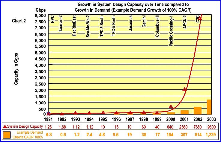
The introduction of DWDM technologies into long haul transoceanic fibre optic repeatered cable systems within the past five years has resulted in increases in the ultimate design capacity of submarine cable systems that are outstripping underlying growth in demand.
Typically, fibre optic system designers have achieved a doubling of fibre transmission capacity every 10 months
since the mid 1990’s. Simultaneously, increases in the number of fibre pairs within the cable sheath have resulted in installed systems with design capacities that have been growing at much faster rates than the underlying growth in international traffic.
The evolution of the Internet through the emergence of the World Wide Web coincided with both a very rapid increase in the level of competition in broadband
connectivity and with the introduction of WDM and then DWDM technologies into submarine cables.
The increases in submarine cable design capacity coupled with an exploding forecast demand for the Internet attracted capital for new submarine cables to meet envisaged capacity shortfalls.
This was supported by an economic view of the “virtuous cycle” of telecommunications as similar to what happened in the semiconductor industry. i.e. price falls would stimulate more demand which would trigger more price falls.
Large amounts of new capital were deployed in the sector, which served to fund further technological developments. These developments contributed to greater capacity and further reductions in unit prices, which was reflected in additional demand driven largely by the Internet. It also generated greater entrepreneurial activity for building more cables of even higher capacity.
This growth cycle suggests that 30-50% annual declines in unit capacity prices seen over the period both for terrestrial and for
submarine systems will continue to be an ongoing feature of the industry.
However, despite the increases in design capacity that cable system designers are able to deliver, these increases are now less likely to translate into lower unit capacity prices.
Why?
For the answer, we look to two areas:
Constraints and incentives for existing cable systems to deliver lower prices
To what extent new cables can deliver lower prices
The Pricing Conundrum
Prices are set in line with the current market and in expectation of a market demand for the capacity and a rate of sales over time (or fill rate of the cable).
In nearly all markets, cables commissioned in the last 3 years are not showing near term indications of filling to anywhere near ultimate design capacity with activated traffic. Most are heavily under-utilised.
Simply, the gains delivered in the optical space have been made faster than
growth in demand. Hence, the market has demonstrated limited ability to utilise the very large capacities now available to be transported by submarine cables.
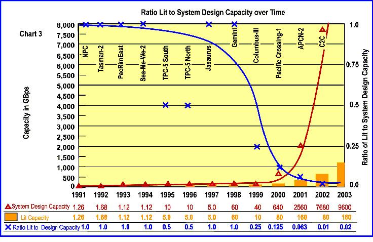
This is reflected in the ever-diminishing ratio of initial lit capacity to ultimate design capacity. Terabit cables are now turned up in initial service with typically 40 to 80 Gbps of capacity. Even with these relatively low equipped levels, not all of that capacity is sold. Of that sold, only a proportion is activated at RFS (Ready for
Service date) with the remaining amounts scheduled for activation up to three years after RFS. As such, there can be a large availability of unused or under-utilised capacity in existing systems for which heavy capital has been expended. This negates any harvesting by buyer or seller of the cost benefits theoretically afforded by greatly increased design capacities.
Yet the spectacular gains from DWDM of the late 1990’s have created expectations that price reductions of up to 50% per
annum, or more, are a normal by-product of DWDM and fibre optic technologies.
Many factors enable price reductions and more than several must be present to support price reductions for an economically rational cable owner. These include
Rate of cash return to the Cable Owner
Fill rate – how quickly the capacity of the cable can be filled at current pricing levels. If customers are not buying, it is more difficult, not less, for a rational cable owner to lower prices due to mounting finance costs
Market elasticity. If price reductions don’t stimulate increased demand to the extent that greater revenues are achieved than would have occurred without reductions, then there is little incentive for price reductions. The late 1990’s concept of the “virtuous circle” of telecoms pricing is being derailed. Factors in the derailment are the dramatic slowing of growth in wholesale demand that has resulted from significant warehousing of capacity from previous purchases, a downturn in
profitability of incumbent telecom operators and withdrawal of sources of funding for emerging operators. No longer do price reductions result because of Technology alone. Rather, price reductions may be enabled by Technology where other necessary factors are also present to support price declines.
Hence there is a real conundrum, because the classical fall in the cost of production with greater volume is not able to be reflected in lower prices. Technology gains are not sufficient of themselves to bring about price reductions.
System Pricing as affected by Costs
The cost of a system includes both initial capital expenditure (capex) and ongoing operating expenditure (opex). All submarine cable systems incur roughly the same cost structure. The major components necessary to put a cable into service include: Preparation costs such as project finance, administration and overhead including design, surveys, licensing and permitting
The “wet plant” cost including the cable, repeaters and branching units
Implementation costs encompassing marine survey, cable landing, cable lay and post lay burial where required
The “dry plant” cost including SLTEs, PFEs and batteries necessary to run the cable system from the shore end Cable Landing Stations including land, surveys, construction, fit out, ancillary power, security and monitoring necessary to provide an environment in which the system can function Terrestrial SDH/Optical switching, protection, and transmission equipment to interface to the backhaul providers
All submarine cable systems incur very high capital costs of establishment. A significant proportion of cost is nontechnology based and includes surveys, design, permitting and licence application, civil construction of landing stations, and the cost of cable laying and landing, including the costs of ploughing in or postlay burial of the cable.
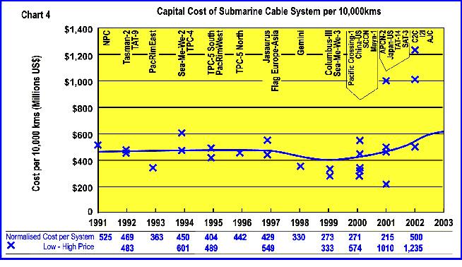
While unit capacity costs of new cable systems have decreased, the “sheath mile” costs of establishing an initially equipped cable system have remained relatively constant, i.e the cost of building a complete
replacement submarine cable system has remained relatively constant when it is normalised for variations in distance.
The chart illustrates that overall initial implementation costs are relatively constant. The major variations in recent years have reflected in some systems going to eight fibre pairs. However the relativity between the four major cost components has changed as major developments in optical transmission have occurred.
For any submarine cable system, the components identified can be assembled
into four main cost groupings, viz:
1.Preparation, Implementation and Cable Station costs which typically are not subject to technological gains
2.The submarine cable and associated optical components
3.The optical plant for generating wavelengths located in the CLS
4.Opto-electronics and SDH equipment required to convert wavelengths into STMs and interfacing with backhaul capacity, again generally located in the CLS.
The terrestrial cost progressively dominates the most recent system designs so gains in optical performance have decreasing impact on the cost.
The rate of decline in unit prices has slowed as the gains achieved in optical capacity have not been met by the market’s ability to use the added capacity, nor has the non-optical equipment been able to meet similar per unit declines
Because of the increasing proportion of dry plant required for larger capacity systems, the rate of decline of unit capacity costs is now being gated predominantly by the rate of decline of dry plant costs.
This is significantly different to the situation five years ago when the cost reductions in the optical technology largely determined the decline rate of the unit cost of capacity.
System Pricing as affected by Demand
Pricing requires a finely judged market assessment that every cable operator must make. Both capex and opex must be fully recovered relatively quickly or else equity may be lost, or worse still, debt servicing may not be able to be met.
Often, by the targeted time for capex recovery, replacement systems requiring higher capex are being considered. Hence market demand vs price is being carefully considered to ensure that sufficient sales will be achieved at the price points offered to ensure full and early capex recovery.
There is a perception that there is a supply surfeit at present. This, coupled with technological developments, tends to move prices in only one direction – downwards. However, it is worth noting that very few new cables have been installed in the last 18 months and that the plans for further cables are generally not well advanced.
Given the gestation period for new cables and the shortage of capital available to expand existing cables, there are situations where, due to internet growth, there may be a shortage of available capacity. The mothballing of factories would tend to delay a return to a ready supply environment.
Under normal circumstances, the combination of the supply effects would cause prices to rise. So it should not be assumed that in all circumstances the price of capacity would fall.
The conclusion is that in times of low
demand growth and price inelasticity, the cable owner must be very cautious in offering price declines as a means of capturing new sales. The effect of bonus capacity created by price declines can limit the ability of the cable owner to turn lower price points into new sales.
Price protection, and the need to service debt and capital, significantly constrain any declines in price unless the growth rate of demand for capacity exceeds the growth rate relied upon in a systems original business plan.
With the recent tempering of demand growth, actual demand is likely to remain less than the projections relied upon by cable owners and financiers for some time to come. The result is that price declines are likely to remain very modest for the foreseeable future.
The future trend in submarine cable prices will be influenced by changes in both cost and price elements.
Cost Changes:
Optical technology has driven growth in design capacities beyond growth in demand
Gains in optical technology are contributing a diminishing percentage of overall costs gains in unit price of lit capacity.
Cable owners are lighting cables to an every decreasing percentage of design capacity.
Financiers of new cables typically plan for capex to be returned from initial lit capacity.
Relative costs are de-emphasizing gains in the wet plant to the point where the dry plant now becomes a more influential factor in unit costs. The optoelectronic technologies in the interfaces required in the dry plant have not delivered anywhere near the same cost gains as the pure optical technologies have in wet plant.
Space and power in CLS continues to rise as lit capacities increase. This results from dry plant footprint also demonstrating lower gains in productivity.
Replacement cables are generally not considered economic until incremental cost for upgrade capacity of existing cables exceeds unit cost of replacement lit capacity.
Price Changes
The market for wholesale transport has tended to increasing inelasticity as the prices of transport has become an even smaller component of retail pricing. The market for wholesale transport has tended to increasing inelasticity as bandwidth bottlenecks shift from the long haul to metro and last mile issues. Hangover of pre-RFS committed capacity limits owner’s ability to respond to price declines due to effect of bonus capacity in creating excess capacity. Current demand rates are well below forecast rates on which debt servicing was planned. Until capacity growth rates exceed those in the business plans to provide the desired returns to owners, prices are unlikely to fall. Carriers still have excess capacity on some routes which severely limits owner’s abilities to lower prices. Large growth rates in wholesale transport demand have eased as networks complete architectural restructuring, Internet demand is more predictable, and retail data demand is reflecting economic growth rates more closely.
John Hibbard holds a Bachelor of Engineering degree from University of Sydney and a Master of Electronic Engineering from the Netherlands. He has acquired a comprehensive skill base having worked in technical and business operations, planning and marketing before elevation to general management. Recently, he has been Telstra’s Managing Director, Global Wholesale. John is the Chairman of the Australia Japan Cable. He has been elected by the industry to the Executive Board of the prestigious Pacific Telecommunications Council.
Restructured systems are also unlikely to create destabilizing price declines as they rely upon paying recapitalised debt and equity from an inelastic market. Hence they seek to maximize price via differentiation of products and services.
Overall, the annual price declines of 30-50% seen in the late 1990’s are unlikely to return to the industry due to the range of identified factors. Price declines are more likely to reflect moderate rates of 10% or a little more as existing cable owners adjust to current economic realities.
Deregulation and market globalization have hastened the urgency for Asia Pacific to embrace IP and broadband technologies and accompanying e-applications such as video streaming and video conferencing. These technologies and other online ‘conveniences’ require much bandwidth, creating an unprecedented growth in Asia Pacific region. Further supporting this growth, competition and technical advances in developed countries continue to drive down the cost of telecoms services, propelling economic prosperity.
Meanwhile, the regional governments are busy at work to deregulate their telecommunications sector, in order to promote their countries to world-class standards and reap the benefits of globalization.
This trend will continue in Asia’s regulatory landscape as:
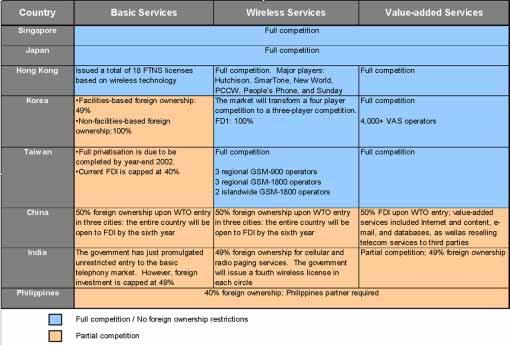
Governmental push for infocomm technology infrastructure investments to support economic growth (eg. Singapore, Hong Kong and Korea)
Reduction in government shareholdings in incumbent telcos as these are usually government owned and operated
THE WINDS OF CHANGE
in the Bandwidth Market
By Tsunekazu Matsudaira, CEO of C2C Pte Ltd
Invite participation of foreign companies and lower the foreign investment limits
Increased demand for backhaul and carrier hotel facilities
(See Annex I)
The rapid market liberalization and privatization have led to the proliferation of new service providers to introduce a host of new services and offerings to the marketplace, causing market share erosion to existing incumbent carrier. This had created complications in the traditional correspondent environment, making it difficult to forecast bilateral traffic growth over a multi-year planning horizon.
Coupled with the upheavals in the current market with some failed carriers and providers bailing out of the bandwidth industry, many investors and supporters are losing confidence. However, this is where the surviving bandwidth providers will strengthen their market position.
Changing Bandwidth Demand Pattern
What has happened over the last 12 months was nothing short of a total meltdown of the
bandwidth market. Several known companies have buckled under huge financial difficulties and accounting scandals. Plunging bandwidth prices and inadequate demand from customers are also not helping the situation.
However, not everything is as gloomy as suspected, especially in Asia Pacific.
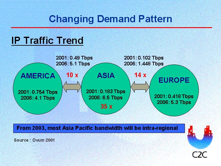
It was forecasted (Ovum Report 2001) that the IP Bandwidth in Asia to the Americas would grow from 0.5 Tbps in year 2001 to 5.1 Tbps in year 2006, signifying an increase of 10 times over 5 years. Where intra-Asia is concerned, the forecast is 0.18 Tbps in year 2001 to 6.5Tbps in year 2006.
This would mean a phenomenal increase of 35 times in IP Bandwidth demand over 5 years! (See Annex II)
Realistically, there is still much pent up demand for bandwidth, especially with emerging market giants such as China and India entering the global arena. Both will require much bandwidth because: Both countries are two of the most populous nations in the world
Both countries have the muscle to finance the numerous initiatives to put their nations on the road to globalization
Both countries currently have low mobile and Internet penetration rates for nations such as their size, but this is expected to change as telecom providers in China and India are recording phenomenal growth for both mobile and Internet services
China has already joined the World Trade Organization, encouraging the country to rapidly deregulate their market sectors and aggressively court foreign investments
China is hosting the 2008 Olympics India is well-known for its huge pool of software developers
not paint a rosy picture, but it is the survivor of the fittest and it does provide the surviving bandwidth providers an important supporting role to play.
Changing Customer Trends
The current ‘gloom and doom’ situation of the bandwidth industry might
These factors will make a major impact in the globally, especially promoting intraAsia and global traffic. Moreover, with Asia coming in grips with the numerous emerging markets in other developing countries besides China and India, there are many opportunities for bandwidth providers to capitalize on these emerging trends.
Those left have to quickly re-invent themselves and their business models to handle the expected churn generated after the massive market upheavals. This is where C2C cable network and bandwidth providers with similar qualities are expected to capture the lion’s share of the market: Be fully funded. Many of those companies have collapsed under massive debts and ‘creative accounting’. As a fully funded entity, it gives the customer the boost of confidence that the provider will be around for the long run, as typically commitments to IRUs do have to last the lifetime of the cable network. Customers are moving towards leases. This is where innovative business solutions will win the deal. Though leases are short-term based commitments, innovative payment schemes, flexible portability and good reputation have much higher chances to convert leases into IRUs.
Having reliable and reputable partners. This also improves the customer confidence index. With SingTel as a major shareholder of C2C, and including other partners who are also C2C’s landing parties, the network is here for the haul.
City-to-city connectivity. By providing the connection right into the heart of the city, it gives the customer the competitive edge of quick deployment and less headaches when negotiating for a cost-effective network.
Have a landing point in China and India. This is where the bulk of the bandwidth demands will be generated.
C2C cable network is the first private cable operator to have landed in China Mainland. Having the first-mover advantage, a local partner and an indepth knowledge of the local regulatory issues, it gives the customer peace of mind when entering the China market. C2C also interconnects to its sister network, i2i (which links Singapore to India), thereby providing connectivity to India as well.
Having a well-designed and adequate network. With a double loop connecting north and south Asia providing redundancy and reliability, and a capacity of 7.68 terabits, C2C provides customers with various options to expand their own bandwidth requirements balanced against their business needs.
Changing For The Better
The changes in the telecommunications landscape, demand patterns and customer trends have created a much tougher business environment to operate in and making it harder to predict what is going to happen next.
However, it also created many opportunities to be capitalized by innovative business solutions and costeffective infrastructure.
Looking ahead, the bandwidth market is expected to bottom out soon, and therefore it is opportune time for the surviving providers to put their act together and accommodate the rapidly changing business environment, and customers will be looking for the best deal.
Mr Tsunekazu Matsudaira joined C2C in January 2002 to head the private cable development company. He is responsible for the overall management of C2C, including planning, implementation and operations of the C2C network infrastructure, as well as driving the company to be the leading wholesale bandwidth provider in Asia.
Prior to joining C2C, Mr Matsudaira was the Managing Director (Board Member) and Senior General Manager of the International Relations Division in KDDI of Japan. He was also a senior executive for more than 10 years at KDD, before the company’s merger with DDI and IDO in 2000.
Mr Matsudaira has a Bachelor of Laws (LL.B) from Gakushuin University in Tokyo.
About C2C
C2C is a cutting-edge private cable development company developing one of the world’s largest submarine cable networks. The 17,000 km cable network uses state-of-the-art Dense Wavelength Division Multiplexing (DWDM) technology to meet the needs of next generation networks.
Unlike traditional submarine cable systems in Asia that provide shore-to-shore connectivity, C2C works with local carriers in various target markets to provide a one-stopshop for city-to-city (C2C) connectivity. This
means that C2C customers can purchase capacity on direct links to major business centres in Asia and the US from C2C and its landing parties. Capacity on the C2C network is available wholesale to other carriers that need to carry traffic to, from and within the Asian region and onwards to North America.
C2C’s investors include SingTel, Globe Telecom (Philippines), GNG Networks Inc (South Korea), iAdvantage (Hong Kong), KDDI-SCS (Japan), New Century Infocomm Company (Taiwan) and Tycom Asia Networks (USA).
Event Theatre is an audio-visual presentation that showcases products and services. In 2003 and beyond, Event Theatre will be established at Underwater Intervention, Offshore Technology Conference, Oceans MTS/IEEE and other conferences.
Showcase the products and services of your company by including Event Theatre in your advertising initiatives. Event Theatre presentations will be viewable at conferences in a video den that is appealing and convenient for conference delegates.
The multimedia advertising platform will entertain your prospective customers and enable them to see and hear your sales messages while relaxed and in a receptive state of mind. Repeatedly, viewers may watch images of your equipment or people in action. Sights and sounds will inform the audience of your news and the benefits of your techniques and technologies.
The team will work with you to create a corporate video or commercial for your company or welcome your pre-produced clip. This is an easy and inexpensive advertising tactic. Join others in the marine arena contributing to this community audio-visual dynamic. Contact Pamela Barnett, Pamela@EventTheatre.com.
The next 25 weeks:
Companies with room in their budget for advertisements in the next two editions of PTR magazine will have the opportunity to gain the attention of people involved in global network activity at two important conferences: ITU Telecom Asia 2002 and PTC2003.
Advertisers in both of these editions of PTR magazine will also be positioned to reach their customers and prospects at IEC @ SUPERCOMM Roundtable Forums 2002, Global IP Carriers Asia 2002 and other conferences.
Secure space in the magazines and the Conference Program . . . utilize the services of the PTC team in creating a corporate video that will catch the attention of PTC2003 delegates every day . . . do it now. Here’s why:
Companies that make their plans now will have a great marketing advantage connected with PTC2003. They will be entitled, for a small fee, to purchase space on the conference website for their banner. For the next 25 weeks, their banner will be viewable in a prominent place on the conference home page.
Please call Pamela Barnett, phone number +1 520-384-6420, or email pamela@vtc.net, who will appreciate a chance to assist you in obtaining affordable and strategic visibility.
THE APPLICATION OF AUTONOMOUS UNDERWATER VEHICLES FOR CABLE ROUTE SURVEYS
by Graham S. Evans
AUV
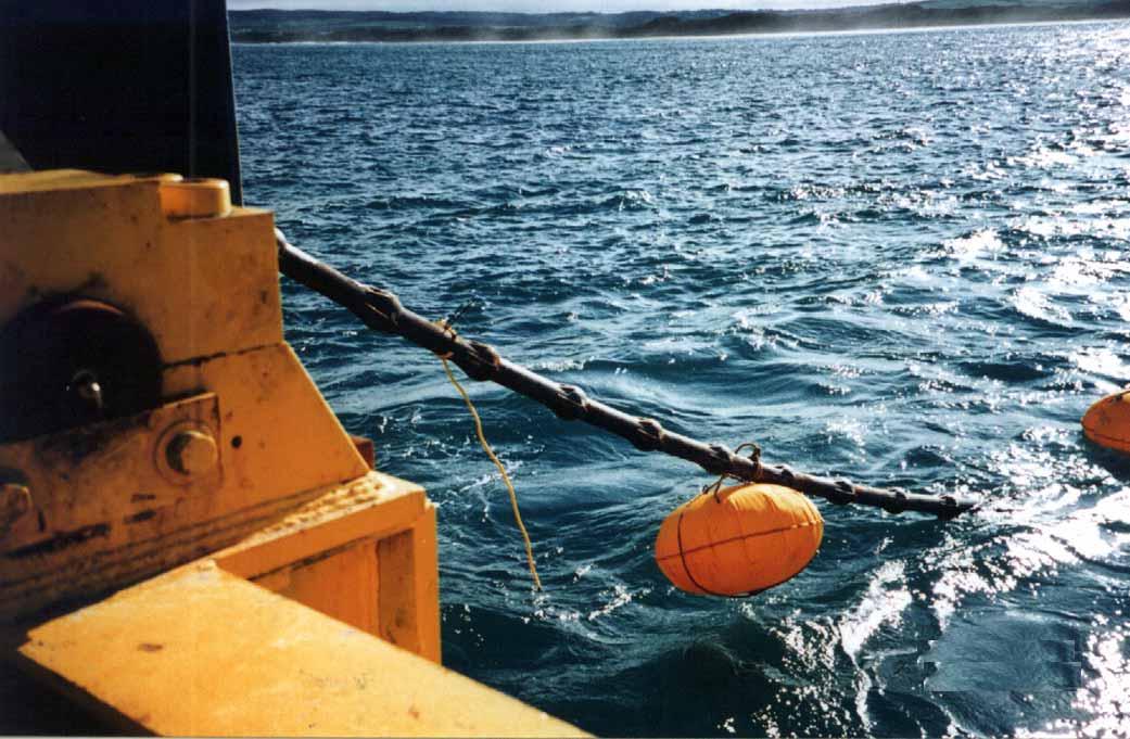
During recent years, there has been an increasing focus on burying submarine cables in deeper and deeper water. Ten years ago, burying cables to water depths of 200m was the norm, now; it is not uncommon for burial to be required to depths of 2000m or more. For the cable installer, burying cables in these depths presents a particular range of challenges.
Not least of these challenges lies in the fact that burial tools, particularly ploughs, are operating close to the limits of stability and controllability, where even small seabed obstructions and have resulted in the loss of control of equipment which in turn can result in the failure to meet burial specifications, damage to the cable, or in extreme cases, the entire loss of the plough.
To mitigate exposure to such risks, and the resulting consequences of installation mishaps, it is important for a cable installer to fully understand the nature of the seabed surface and sub-seabed conditions along the path of the burial vehicle prior to commencing installation. Understanding the nature of the seabed requires that any potential hazard to burial operations lying in or close to the path of the burial vehicle is clearly identified and accurately mapped.
The performance of conventional electronic survey tools operated from surface vessels is limited when reliably identifying and accurately mapping potential hazards in deep water. However, the application of new generation Autonomous Underwater Vehicles (AUVs) has clearly demonstrated that the
limitations of conventional survey methodology in high-resolution mapping in deep water can be overcome.
The primary data sets typically collected during the electronic route survey comprises:
Multibeam bathymetric data providing information on the topography of the seabed
Sonar imagery data which provides information on seabed surface features
Seismic profiling data which provides information on the sub surface soils and geological profile.
To provide the installer with physical information on burial conditions, these are usually augmented by data provided by a burial assessment survey (BAS).
In shallow water, the resolution of the various electronic data is usually adequate to identify and accurately geo-reference the spatial position of objects and seabed features likely to be hazardous to burial operations. As water depths increase, the laws of physics play an increasing role in degrading resolution with increasing distance between the transducers and sensors of the survey equipment being used and the seabed. To maintain optimum resolution in deep water, survey tools can be towed such that the distance (altitude) from the seabed
is minimised, however, in deep tow operations, the accurate geo-referencing of objects becomes more difficult.
The primary advantage of terrain models generated by multibeam bathymetry lies in the technique’s ability to rapidly collect bathymetry and co-located backscatter data from large areas. However, an ideal terrain model would be an infinite and continuous set of accurate point values for depth, precisely positioned horizontally. This ideal is best approximated by a profile near the seabed, where the survey sensors travel along the actual route, and where the sensors are accurately geo-referenced.
Noise is minimised and can be further reduced through data processing. In deep water, the only method available for collecting
near seabed data, until the advent of the AUV, was to use a deep tow survey vehicle in which all required survey sensors were installed.
The disadvantage of using a towed nearbottom survey system to generate the seabed profile in deep water is time and cost, and degraded spatial accuracy of data. Deep water profiles created by surface operated multibeam systems have nearly opposite attributes to near bottom instrument generated profiles; they are fast, inexpensive per unit area covered, but soundings can be far apart, taken from an overly large area, and have considerably more noise.
As a result, although a profile taken with a surface mounted multibeam sounder in deep water can be a reconnaissance tool to find some of the problem areas on a potential route, a
follow-up survey with a near bottom survey instrument may be required to discover smaller scale features that could pose a significant hazard. Seabed shape can also have a significant impact on the accuracy of the seabed profile measured by multibeam systems.
The following graphs illustrate how the shape of the seabed can influence the accuracy of the measured seabed profile for a high performance multibeam system.
Graph 1 shows a near ideal case of achievable performance. Except for minor problems at peaks and troughs where curvature is greatest, good performance is indicated. Graphs 2 and 3 show how system performance degrades as spatial wavelength gets smaller. Graph 4 shows how the system performs on a
Graph
complex bottom formed by summing three sinusoids of different lengths. As can be seen from the graphs a complex seabed shape will be progressively smoothed with increasing distance between the seabed and echo sounder sensors.
Another key tool that forms part of the suite of equipment used during the electronic route survey is side scan sonar. Side scan imagery provides a plan view of the seabed surface along the survey corridor centred on the track of the survey vessel. The data output from these systems provides valuable information on seabed topography that can be correlated with bathymetric data, it also yields information on the characteristics of the seabed surface sediments, enabling rock and coral outcrops, and non geological objects to be identified and mapped.
As with multibeam echo sounders the ability of a side scan system to resolve potentially hazardous objects on the sea floor is determined by the height of the transducers above the seabed and the range setting of the instrument. Side scan sonar resolution is usually defined in terms of across-track and along-track resolution. Along-track resolution approximates to three times the inter-ping
travel distance, which is the distance the sonar moves forward between each transmission ping.
Across-track resolution is almost always better than along-track resolution, so much so that it can be ignored for most purposes. Alongtrack resolution is range sensitive. As the range setting of the sonar is increased the ping rate slows down as it takes more time for the signal to travel to the end of the range and back.
Another issue impacting the ability of side scan sonar to identify potential hazards to cable burial concerns grazing angle and the fact that there are no acoustic shadows close to or directly below the sonar transducers.
In effect, this means that selecting greater ranges to cover a specified corridor width with the minimum number of survey lines, requires that the tow fish needs to be towed at higher altitudes, which in turn results in a bigger zone with no shadows, which in turn requires that line spacing needs to be chosen such that adequate overlap exists between adjacent data sets.
In general, and depending on the equipment being used, to optimize the identification and resolution of potential hazards, the operation of side scan systems
Based in Singapore, Graham Evans has the dual role of Director of International Business Development for the EGS Group and C & C Technologies Inc.
Graham has more then twenty-five years experience as a geologist and applied geophysicist. He is a Chartered Geologist and holds a BSc degree in Geology from the University of Manchester, UK and a BA degree in Earth and Environmental Sciences from the Open University, UK.
requires that the tow altitude be within the range 10-15% of range setting, and tow speed be kept within 2-3% of range setting, and that adequate data overlap exists.
In deep water, applying the above criteria, it is obvious that sonar systems need to be deep towed. In order to tow side scan fish in deep water, survey speeds need to be low, typically ±2 knots, and tow distances (distance between survey vessel and tow fish) will typically need be 2.5-3 tow depth, therefore, a tow depth of 1,500m requires a tow distance of some 4.5 km.
At these tow distances and survey speeds, not only do line turns require several hours to accomplish, the correct geo-referencing of
objects identified by towed systems is degraded due to inherent weaknesses in acoustic positioning accuracy.
A very important characteristic of acoustic positioning is the degradation of quality with increasing range. Commonly, acoustic positioning signals reach extinction ranges between ±3000m to ±4000m, this equates to a tow depth of ±1,000m to ±1,500m. Extinction will occur at shorter distances in adverse sea conditions.
In the oil and gas industry, it is common to use what is referred to as a two-vessel shoot, with survey vessel towing survey equipment and a second vessel sitting above the towed vehicle maintaining the acoustic positioning link. The submarine cable industry uses this technique very rarely due to cost.
Most of the errors that are intrinsic to acoustic positioning, such as compass and ray bending errors, scale with range. However, the ability to accurately measure direction declines as a function of the square of the range.
The following graph shows USBL performance.
Expected noise for a USBL positioned fish towed with a 3:1 scope based on published specifications
Numbers agree well with better USBL performance.
The discussions shows that conventional survey techniques using surface or near surface survey tools do not provide adequate resolution of small scale seabed obstructions that pose hazards to burial in deep water.
By using deep tow techniques, the identification of small scale obstructions and hazards can be resolved, however, georeferencing identified objects in their correct spatial position is inadequate due to inherent weaknesses in acoustic positioning, unless a two vessel operation is mounted.
Autonomous Underwater Vehicles
With the 2000 launch by C&C Technologies of the first commercially available deep water Autonomous Underwater Vehicle, the Kongsberg Simrad Hugin 3000, all the shortcomings found in the use of conventional survey tools and techniques in deep water have been addressed and eliminated.
The Hugin 3000, unlike traditional deeptowed systems can work in water depths from as little as 10m to as deep as 3000m and collect data with proven repeatable vertical and horizontal accuracy. If used in pure autonomous mode, an additional shallow water survey launch for the near shore survey can be dispensed with, corresponding to a reduction in survey duration.
With AUV technology, the long tow cable and attendant problems associated with acoustic positioning extinction is eliminated, as are time consuming line turns.
The Hugin 3000 operated by C&C Technologies, has a payload that includes highresolution multibeam echo sounder, chirp side scan sonar and chirp sub-bottom profiler, enabling all survey data to be collected from an optimum and constant altitude above the seabed.
The C&C Hugin 3000 has been operating continuously since October 2000 and has completed more than 6,000 kilometres of survey up to June 2002.
Underwater positioning and vehicle attitude is provided by a Kalman filter aided Inertial Navigation System (INS) integrating data from an Inertial Measurement Unit (IMU), Doppler speed log, fibre optic gyro, depth sensor, altitude/forward looking sensor, USBL (or optional LBL), and DGPS. The fibre optic gyro also provides heave, pitch and roll measurements. Telemetry for vehicle command and control, and for reading survey sensor data is provided by two underwater telemetry systems. Surface operations employ UHF radio communications.
In the strict sense, the Hugin 3000 operated by C&C is not a true AUV as it has been developed with an ‘acoustic tether’ and is therefore, more accurately described as an Untethered Underwater Vehicle (UUV). Although the Hugin 3000 has full autonomous capability, this would only be used under unusual circumstances.
The acoustic tether provides supervised autonomy enabling engineers to control data quality through the high speed acoustic link,
Hugin 3000 On-board Systems
and to control the survey by providing the ability to modify the mission through active mission control via the low speed command and control acoustic link. With this level of sophisticated two-way acoustic communications, sub-sampled data is transmitted to the surface; with this capability should other hazards be identified, it is easy to adjust mission parameters for development work.
As discussed above, reliable deep-towed USBL positioning in depths over a few hundred meters is the exception rather than the rule.
Complex water sound velocities, coupled with poor incident angles, create ‘ray-bending’, a major impediment to marine acoustic positioning. Deep towed fish, typically towed at an angle of 30° down from the tow vessel’s positioning transceiver, are susceptible to the effects of ray-bending. The adverse effects of
complex water sound velocities are greatly diminished with AUV operations as the acoustic incidence angle, approximately 90°, is ideal. This is a consequence of the support vessel following directly above the AUV during survey operations. Poor acoustic interfaces are met head-on minimizing the effects of ray-bending errors. Additionally, the AUV relies on inertial navigation Doppler velocity log as its primary positioning source, therefore, only occasional USBL updates are required to provide accurate positioning.
AUV Advantages
Survey Speed
AUVs operate at survey speeds within the range 3.5-4.5 knots compared to deep-tow systems, which operate in the range 2.0-2.5 knots, an improvement of 60% to 75%.
Line Turn Capability
An AUV can turn from one survey line on to the next in typically under 5 minutes compared to a deep-tow system, which may require from 4 to 6 hours to complete a line turn, an improvement of more than 90%.
Positioning Efficiency
As discussed above, deep-towed systems are typically towed several km behind the survey vessel. This may result in data being collected hundreds of metres off the intended track line, depending on prevailing currents. This typically requires additional lines to be surveyed with each additional line requiring the 4 to 6 hour line turn. By contrast, AUVs navigate along the exact pre-defined line following the route position list with heading adjustments at alter course points being made automatically.
Procedural Efficiency
Alter course positions along cable routes where cable burial is required in deep water place serious restrictions on survey efficiency for deep-towed systems. Each alter course is treated as an end-of-line precipitating a 4 to 6 hour line turn. AUVs do not have this restriction; heading changes along a survey line become
simple mid-course corrections, which are easily accomplished.
Effective Aspect Ratio
Maintaining the correct height above the seafloor is crucial to obtaining quality survey data. In areas of undulating seabed, a deeptow system requires a precise balance between vessel speed and cable pay-out and recovery to maintain constant tow vehicle altitude. AUVs employ sophisticated echo sounders, and can be programmed to follow the prevailing seabed profile. Integrated with obstacle-avoidance sonar and precise Digiquartz depth sensors, an AUV can be instructed to maintain a constant altitude above the seafloor or constant depth below the sea surface.
Manoeuvrability
High manoeuvrability and accurate positioning enable AUV systems to work in close proximity to anchored rigs, platforms and barges.
Data Resolution
The ability of an AUV to ‘fly’ at optimum altitude above the seabed, means the system can be equipped with high resolution sensors, which in turn result in accurately positioned
and very high resolution bathymetric data and co-located imagery.
For example, a surface operated multibeam echo sounder in 2000m depth will give a depth resolution of approximately 7m, conversely, an AUV will provide a depth resolution of 0.2m. Similarly, side scan sonar imagery collected from a near surface towed system will give a pixel size of 40m, the side scan data from an AUV will provide a pixel size of only 0.5m.
Support Vessel
AUV operations only require one vessel to support all processes including vehicle launchand-recovery, positioning, data collection and processing, and system maintenance. Deep towed systems can also operate with a single vessel. However, once operations move into depths exceeding approximately 600m, accurate USBL positioning normally dictates the need for a second survey vessel or chase boat.
Time and Cost Savings
The increased efficiencies discussed above provide for significant savings in survey duration, and even with a higher spread cost for the AUV over a deep-tow system, substantial savings in survey costs have been proven.
Eat.Drink.Broadband.
A feast for your senses with enlightening presentations, interactive meetings, networking events, exhibits, and more. Satisfy your hunger for ideas and information at PTC’s 25th Annual Telecom Conference in Honolulu, Hawaii. Register now online at www.ptc.org/ptc2003 or call +1.808.941.3789 to receive early registration discounts.
By Toby Bailey
Sit on a three-legged bar stool in a bar anywhere around the world and as a general rule it won’t fall over (without alcholic provocation that is!). In the dynamic world of the telecoms industry a three-legged strategy may hold the key to the survival and continuity of supply for a number of smaller companies.
A case in point is the recent history of The Engineering Business Ltd (EB). Like many engineering companies, EB rapidly
expanded its business by supplying equipment to the growing submarine telecoms market. EB specialised in designing and building submarine cable installation equipment, in particular cable ploughs and their associated deck equipment. During the rapid period of growth of the submarine telecoms sector there was a constant drive for equipment that could bury cable deeper, gentler, faster and cheaper. EB focussed its engineering
talents on this area, developing a new range of cable ploughs, culminating at the peak of the “arms race” in the design and build of two Sea Stallion 3 systems.
These featured a wide range of technical innovations to meet the above aims. For example, an integrated vessel control system that integrated the plough operating system with other vessel systems such as survey and DP. The control system also permitted control of the entire cable installation process from the bridge reducing manning levels and increasing operating efficiency. Productivity was further enhanced by a buoyant umbilical system (the first to be judged a success in a cable plough application) that allowed the plough umbilical cable to be deployed without manually adding floatation.
At the sharp end an aggressive share allowed full depth burial of cable and repeaters up to 3m in a wide range of seabed conditions whilst its design also minimised the residual tension in the buried cable.
Unfortunately, after spending thousand’s of man hours developing and proving these new technologies the market for additional new systems all but vanished
in the telecoms crash of 2001. The potential impact of the crash could not be underestimated – Global telecom companies such 360 networks and Global Crossing were going into Chapter 11 and there was an excess of bandwidth. With no new systems to install, contractors were mothballing equipment and laying off crews.
EB by this stage was a fully developed company employing 35 people, with ISO9001:2000 quality certification, a proven product range and an after sales support team. However, the company faced zero demand for new equipment and a significant drop off in parts and support requirements. Bad debts were inevitable and at its worst EB designed and built a complete plough spread for a customer who then went into liquidation.
The optimists amongst us still contend that given time that the market will recover. However in the meantime it is essential that the smaller suppliers survive the crash –firstly for the employees (including yours truly) and also for the continuity of supply and support for their existing customers.
This is where the 3 legged stool
principle comes in. The standard solution to a market crash such as the above is to diversify. EB’s philosophy was to take this one step further and in contrast to some recent corporate thinking had aimed from day one to apply its engineering skill in three distinct markets – submarine telecoms, Offshore oil & gas and renewable offshore power generation.
Offshore oil & gas is well renown for its cyclical nature but EB had been doing reasonably steady business in this sector since the company was formed in 1997. Although the companies (and charactors) operating in the offshore oil and gas sector are significantly different to the telecoms industry there is a degree of cross over in seabed trenching technology. Fortunately at the time of the telecoms collapse the demand cycle for subsea trenching equipment was on the up and for continued survival it was essential that EB expanded its activities in this sector.
With an active demand for new pipeline installation equipment EB has used its recent experience to develop an all new pipeline plough, the Sea Titan. In simple terms its design aims are similar to telecom
Toby Bailey is the Sales and Marketing manager for The Engineering Business Ltd (EB). He joined EB in January 2001 from a global agricultural engineering company and is responsible for promoting EB in all its market sectors. Toby has seen both the highs and the lows of the submarine telecom industry but with the continued growth of EB remains optimistic for the future.
ploughs – i.e the rapid and effective burial of a product below the seabed. However, like J.R Ewing you have to think big! Oil and gas pipelines can be up 42" in diameter and pipeline ploughs have to be able to create a stable V-trench 2 metres deep. The Sea Titan will be approximately 100 tonnes in weight and can withstand a bollard pull of up to 250 tonnes – in comparison a Sea Stallion 3 plough weighs 29 tonnes and can withstand a bollard pull of 130 tonnes.
The first Sea Titan will be delivered later this year and EB continues to develop other products for this market, including a pipeline jetter and a seabed tractor.
One plough (whatever its size) cannot ensure the survival of a company the size of EB. The third leg of EB’s stool that has grown rapidly in the past 18 months is Renewable Offshore Power Generation. EB has been developing a system for Tidal Stream Power Generation since 1997, with the idea of transferring proven technology and knowledge from its other 2 markets into the design and build of a successful subsea generator.
However, progress in the late 90’s was restricted by a lack of resources and a lack
of funding. With the collapse of the telecoms market, EB could apply more resources to the development of its generator, Stingray, but still needed cash to fund what is basically an expensive research and development programme. Fortuitously, the availability of engineering resources coincided with an increased level of interest in renewable technology both from government and private investors. Ultimately this led to the securing of 75% funding from the Department of Trade & Industry for a £1.8 million project to build a Stingray demonstrator to prove the economic and practical feasibility of the concept.
The first demonstrator is to be installed this summer off the Shetland Islands in 30 metres of water. This is certainly not a project without risk and to date EB has invested almost £1 million of its own money in its development. If the demonstrator proves successful the potential market could be huge. Tidal stream energy is completely predictable in comparison to other renewable resources, for example wind and wave, and farms of Stingray generators could be installed with minimal visual impact – watch this space.
The recent history of EB demonstrates the realities of operating in the modern business environment. To survive, you need to be able to react quickly and to have a certain degree of luck. It has also highlighted the truth in another old adage “don’t put all your eggs in one basket”. In summary working in three markets spreads risk but also undoubtedly incurs higher costs – for example, the development
Sea Titan
Sea Stallion
of a wider range of products and technologies, the funding of a much broader sales and marketing effort and the higher costs of managing a range of very different projects. However, it is certainly the case that the diverse business strategy followed by EB has enabled the company to best support the telecoms industry
through very difficult times and has helped it avoid the worst effects of the telecom crash in terms of layoffs and business failure. With the submarine telecoms industry showing some signs of life it will certainly be interesting to reassess the relative strengths of the stool’s three legs in another 5 years.
Stingray
Pioneer Pioneer Pioneer Pioneer Pioneer
may neither provide the model the financial institutions think they want nor meet the desires environmental agencies have on their wish list. Furthermore, no single company has the best of everything, although we all know this may be claimed. All these elements should all be as obvious as the fact that the purpose of system suppliers, cable installers and service companies is, ultimately, to make a profit.
experience with experience with experience
. . . . . . . . . . . . . . . with experience with experience with
How many people reading this article can say with confidence that they will fulfil their obligations to their investors, their shareholders and their customers in the coming months and years ahead?
The following may all be obvious to many of you, however, perhaps we have got to the point of not seeing the wood for the trees.
The objective of a submarine cable system is to provide a reliable cost-effective service for its users. A consummate installation depends on the combination of leading edge and reliable technology, excellent information and the most effective planning and procedures that exist in the market place. Even then the results of this hypothetical idyllic performance
It is imperative to secure the long-term success of the industry with continued development and improvements in technology. In order to achieve this companies involved in the submarine cable business require sufficient means with which to improve the marketplace. I think it is appropriate, therefore, that the industry takes a step or two back for serious consideration of where it has been and, more crucially, where it plans to go.
Unfortunately we have already reached the unacceptable situation of customers avoiding additional costs whilst contractors try to increase revenue by claiming CV’s - in other words the adversarial contracts mentioned in the last issue of Submarine Telecoms Forum. The trouble is
that all this has already happened - even before we reached the stage of a buyers market. How much worse could it get?
Our industry is crying out for technology improvements to support improved and speedier installation and a shorter time to market. So how are we going to obtain these ideals? Commercially and realistically none of the Telecoms companies or their associated suppliers, service sector supporters or their suppliers can maintain an effective business unless their individual revenue streams support it. Let alone have sufficient profits to put some aside for R&D.
My view is that this can all be achieved by the tough but fair administration of realistic and profitable contracts. That means not being frightened to make a claim for a legitimate CV, and by allowing technology to support the experience the submarine cable industry has at its finger tips, not replace it. Well that’s obvious I here you all say. That is what we do now. But brace yourselves - the truth is - it isn’t.
What happens is a party agrees to 100% burial to some ridiculous depth below the seabed in solid rock out to a water depth
where no one uses the seabed and no ships anchor. This may be an idealistic view set by an ill informed purchaser or even a mandatory requirement set by financial or governmental institutions, fishermen or environmental agencies. In response the installers cringe and simply guess (even if the guess is based on some well-meaning plan of work) at how much risk money to add to the contract price in order to meet the performance requirement - or in most cases not.
This may be a recognised practice in the civil construction industry; however, they are also, I believe, more practical in the administration of variations. Where the situation under which a variation can be claimed (or not) is somewhat clearer in the contract.
At the end of the day, what has been achieved? Probably the worst relationships between supplier and installer in recent history, possibly even worse relations between the system owner and the system supplier.
However, if one looks at what one was trying to achieve - the best reasonable protection of the cable throughout its
Chris Butler has a 13-year background with the commercial and contractual aspects of submarine cable installation. Technically qualified he has the advantage of looking at the industry from the eyes of system supplier, shallow water specialist and deep water installer and has enjoyed the responsibilities of Product Management, contract negotiation and profit & loss. Chris is currently operating from London as the Commercial and Business Development Manager for Houston based Smit-Oceaneering Cable Systems, L.L.C.
lifetime - the story should be different. But it seems we have forgotten that altogether. Millions of dollars is spend on route survey work that is often effectively consigned to a dusty shelf because the system supplier has made manufacturing decisions based on his budget, schedule and desk top study, prior to receipt of the electronic route survey results. The installer may then have no choice except to use a less than optimal route, restricted by pre-determined armour
types, cable lengths, transitions and repeater positions.
In the end everyone then ends up losing money delaying schedules and wasting time arguing over whether some part of the installation was possible or not in the first place. So what is required to breathe life back into an industry paralysed by an unfathomable mixture of viruses? How do we get away from and replace the gung ho attitude of we can do anything at any price (and we’ll cover up the bits that we don’t) which may look good on paper at the start of a project?
Rob Munier’s article “Mind the Gap” in the last issue of this magazine explained in some detail the problems the industry is facing and why. I am aiming to go one stage further and ask those here in our industry to stop talking and do something to jump start it and bring it into the 21 st Century.
Don’t think for one minute that I’m suggesting either some form of anarchy or the mountains of paperwork and procedures common place in the oil and gas industry - quite the opposite. A return to practical, clear, concise contracts, engineering pioneered by experience,
supported by technology and administered by empowered decision makers throughout the supply chain.
I don’t believe this should compromise speed to market. Instead we get schedules that can be achieved, installation targets that are agreed and a reasonable and clear understanding of what aspects will be subject to CV’s. In short, mutual acceptance and benefit to all parties across a project.
All aspects of the industry must embrace a change toward positive, informed and innovative engineering. Creative thinking and challenging installation approaches need to be rewarded - not penalised by unachievable commercial conditions. This will lead to a competitive advantage for those companies that have the best and most cost effective operations, rather than those who have deep pockets or are prepared to gamble on promising the earth, often delivering something only somewhere vaguely approaching the contractual requirements. This latter approach often becomes commercial suicide in turn penalising suppliers who were bullied into accepting unrealistic contracts in the hope of success rather than in expectation of it.
If we carry on at the current rate there is likely to become a monopoly in the submarine system supply and installation industry. Conceivably, this means no system owner ever getting the quality of performance he specifies again. It up to us to do something about it! How else to we ensure this business survives with ground breaking developments, leading edge underwater technology and state of the art performance?
For all your personnel requirements:
ITG’s new Branching Unit
By Nancy Poirier and Yves Baribeau
International Telecom Group’s Universal NY Branching Unit (NYBU) has been specially developed for repeaterless submarine telecommunication systems.
The major goal of the branching unit design was to be capable of standardizing the manner with which various types of cables may be secured to have continuous load distribution. ITG’s first NYBU was successfully deployed during the Bahamas Internet Cable System (BICS) installation in December 2000.
Reliability of submarine systems has always been an important criterion for route and system engineering. Although it is known that festoon systems lack any internal restoration path, system installers continue to prefer the festooned to the branched configuration; this being due mainly to the fact that festooned networks were always simpler and at lower cost.
ITG designed and built an ultra compact, fast and easy to assemble passive branching unit. The NYBU can
accommodate very high fiber count and is adaptable to any cable types, making it a cost effective solution for reliable branched systems.
The primary design objective of the NYBU was to make it very reliable. A reduced number of pieces would simplify the assembly and thus diminish the risk of incorrectly installed or forgotten parts. The NYBU mono-block design meets this requirement and is assembled with a combination of only 10 different pieces plus standard hardware (o-ring, screws and heat shrink tubes). Readily available material and hardware were procured to maintain high quality, low cost and fast delivery.
Most branching units are developed for one specific type of cable and require extensive development to be adapted to others.
The ITG design team looked at the main cable types available and determined that the NYBU could be modified with only minor changes. A universal design provides adaptability in a timely manner and with minimal engineering cost.
The unit is designed to be assembled onboard a laying vessel without the use of
cable tails, thus minimizing the total number of splices in the system and maximizing transmission margin.
To facilitate deployment and reduce machining time, university and research
Nancy Poirier is a graduate mechanical engineer. She has worked for Teleglobe Marine for several years where she was involved in the project management of several projects including CANTAT-3, APOCS 2 and Can-US.
After Teleglobe she was employed by MPB Technologies, working as a design engineer on the development of undersea devices such as branching units and splice boxes. Her first passive branching unit was deployed in Greece for the MINOAS Project in 1995.
After MPB, she joined IT International Telecom. She has been the project manager for multiple projects including the Bahamas Internet Cable System (BICS) for which she designed and deployed the NYBU, IT’s ultra compact passive branching unit. In addition to her other activities Nancy has developed a new design of articulated split pipes.
center material specialists searched to locate a light material that would be inexpensive and easy to machine. For over 40 years marine grade aluminums have been developed. Aluminum alloys with silicon and magnesium presents very good corrosion resistance in seawater.
Some alloys can survive decades without protection in permanent immersion. By using aluminum, weight is reduced to 32 kg, making the NYBU very easy to handle with two men able to carry it for deployment.
Where necessary to withstand the higher pressure of deeper deployment depths, the use of stainless steel is required to fabricate the housing.
Termination of the armor wires and internal strength members of assorted types of cable is achieved by a cone wedge assembly. The wires are compressed between two cones using a 20 ton hydraulic press, which is the only special tool required to assemble the NYBU .
To maintain the minimum-bending radius of the cable, and to more efficiently transfer load to the housing, bend restrictors are used.
Because the NYBU has an elliptic shape design with an opening on top, the spliced fibers can be coiled directly inside the housing with ample room for manipulation. Once installed, additional displacement of the trays or the fibers themselves is no longer required. To further protect the fibers from micro bend or rupture, fiber bundles segregated in separate fiber trays are stacked as they are filled. The NYBU can accommodate up to 96 fiber splices and various optical fiber routing configurations.
Maintaining the criteria to keep the design simple and to minimize the need for special equipment, overmolding was rejected as a mean of achieving water-
Yves Baribeau holds diplomas in naval architecture as well as mechanical engineering.
Prior to joining IT as a project manager, he worked at MIL Davy shipyard for several years. Since then, he has been involved in multiple projects such has the Bahamas Internet cable System (BICS), Saudi ARAMCO and Apollo.
His technical knowledge has been widely used for the design of cableship deck spread equipment as well as undersea devices, such as branching units and joints for submarine cables.
tightness. Alternatively three layers of sealing are used to assure hermeticity of the device. A neoprene o-ring is the main sealing mechanism. To increase reliability, the unit is covered with epoxy coating. This special epoxy has been developed with a supplier to achieve a fast curing time, resistance to impact and wear.
The coating has two roles: one, to provide an extra water barrier and second, to protect the NYBU from scratching that would affect the anodized finish. Finally,
proven heat shrink technology is used to block water penetration along the cables.
The cable terminations were subjected to a 238 kN pull test. The NYBU then underwent 18 MPa hydrostatic pressure. It is therefore qualified for installation depth up to 1800 meters.
The ITG NYBU was utilized in the Bahamas Internet Cable System (BICS), successfully installed in 2000. BICS’ owners decided to install a branching unit outside the territorial water, leaving a sealed cable tail on the seafloor for future system expansion. For this system, the branching unit was used as the final splice and took less than 15 hours to assemble (including cable preparation and 48 fiber splices). The weight and the compact size of the NYBU have proven to be efficient during the deployment in the 4 knots current of the Gulf Stream.
International Telecom Group’s new branching unit is available to provide a highly reliable means of meeting the undersea demand for short repeaterless branched systems. The universal design can easily be customized to accommodate different brands and types of cable.
SubOptic 2004 is a non-profit making International Convention, organized by the subsea telecoms industry – for the industry and devoted to the exchange of information and discussions of issues affecting global subsea telecoms. It is steered by the SubOptic Executive Committee, which includes the leading companies in the industry and is supported by a worldwide group of scientific and professional organizations and academic communities. The theme for the 2004 conference is “Subsea Networks – Lightwaves around the World”.
SubOptic 2004, the fifth in the series, which started in 1986, will examine the commercial, environmental and technical aspects of subsea optical fiber systems as an essential link in seamless global networks. The program will range from keynote speeches and round table sessions from major players in the industry, to a business and technical program selected by
a Committee of experts in their field.
A major exhibition will also be held with a wide range of different companies from the industry presenting their products and services. This ensures that the depth and breadth of the program is unequalled.
The event is steered and sponsored by SubOptic Executive committee, with delegates from Alcatel, BT Ignite, Cable & Wireless, Deutsche Telekom, FLAG Telecom, France Telecom, Fujitsu, Global Marine Systems, KDD-I, NEC, Pirelli Submarine Telecom Systems, Société des Electriciens et des Electroniciens (SEE), Telecom Italia, Telefonica de España and Tyco Telecommunications.
The Host organization is Alcatel Submarine Networks, 72 Avenue de la Liberté, 92723 Nanterre cedex, France Program Committee Chairman is José Chesnoy, Alcatel, and a number of persons with great experience in the subsea industry are being appointed as vice-chairmen.
The event has the gracious support of the Government of the Principality of
Monaco, in cooperation with, The International Cable Protection Committee (ICPC), The Submarine Cable Improvement Group (SCIG), The Institution of Electrical Engineeers (IEE), The Institute Of Physics (IOP), The Institution of Mechanical Engineers (IMechE), The European Optical Society (EOS), L’Institut d’Electronique Fondamentale (IEF), Centre National de la Recherche Scientifique (CNRS) and The
Where: Grimaldi Forum, Principality of Monaco
When: March 28 th to April 1st, 2004 www.SubOptic.biz
e.mail: hilly.peltier@alcatel.fr or didier.provost@alcatel.fr
KMI’s 25 th Annual Newport Conference on Fiberoptics Markets will provide the market data to help you put your business on track. Hear how suppliers are refining their marketing and manufacturing efforts. Learn how and when carriers are enhancing their networks, with minimal spending and a sharp eye on ROI. The conference takes place October 7-9, 2002, in Newport, RI. For more information, www.kmiresearch.com.
Confirmed Speakers and Topics:
Jimmy Byrd, COO, 360networks: Light at the End of the Tunnel
Thomas R. McPherson, President and CEO, Hatteras Networks: Capitalizing on a Carrier Dilemma.
Darryl Ponder, President and CEO, Optical Solutions Inc: Fiber-to-the-Home.
Claudia Nettig, President & CEO, Cablerunner North America LLC: Metro Installations.
John Struhar, Distinguished Member of the Technical Staff, OFS; Chair, TIA Fiber Optic LAN Section: Fiber to the Desk.
Richard Mack, VP&GM, KMI Research. Worldwide Market Overview and Outlook
Neil Dunay, Senior Analyst, KMI Research. Worldwide Systems Markets
Patrick Fay, Analyst, KMI Research: Fiber and Cable Markets.
Peter J. Farmer, Director, Optical Networking Practice, Strategies Unlimited: Developments in Manufacturing
Give your exhibition or conference maximum exposure to the submarine telecoms industry. Advertise your event in Submarine Telecoms Forum and reach all the key people. Email advertising@subtelforum.com
John Struhar
to to to to to
George Miller, KMI Research
The challenges we face as an industry— however daunting—are understandable in a fundamental economic context, according to John Kasdan, senior research fellow at the Center for Tele Information at Columbia University in New York.
Submarine telecom woes resemble those of the airlines, the early days of telephony, and—yes—even the railroads. But unlike many press accounts that use the railroad analogy to imply a massive industry meltdown preceding the conversion of assets into scenic bicycle trials, Dr. Kasan digs deeper and strikes optimism.
Dr. Kasdan spoke in June at KMI Research’s 8 th Annual Fiberoptic Submarine Systems
Symposium in San Diego. “Railroads suffered from ruinous competition in the 19 th Century until the creation of the ICC,” said Dr. Kasdan. He concluded that for the submarine telecom industry “it appears that an industry structure will develop, allowing participants to profit.”
Achieving Dr, Kasdan’s vision will require a return to the basics. “The initial step must be to clear oversupply,” said Piers O’Connor, president at BIAS/ PICS Ltd. in Rio de Janiero. Some assets will be consolidated while others are abandoned. Mr.
O’Connor said that demand is increasing, but slowly. System upgrades and new builds will occur only where demand is visible. One sector in which demand will be visible is unrepeatered links, according to KMI Research.
Even in these times of tight capital spending, unrepeatered upgrades will account for a growing proportion of submarine market activity. Such upgrades require less capital and have a more readily quantifiable return on investment compared with long-haul and ultra-longhaul builds.
Unrepeatered System Installations (Rt-km)
John Kasdan
at submarine depths
• Cable production experience from 1915 • 2001 state of the art technology
• Worldwide experience in unrepeatered systems
• More than 70 references worldwide from some of the most demanding operators in the industry
• Over 11 000 km cable installed • Up to 384 fibers
For furter information, please contact: for Telecom; Vegard Larsen. Tel: + 47 22 63 76 47, E-mail: vegard.larsen@nexans.com Contact for Oil & Gas; Jon Seip. Tel: + 47 22 63 88 25, E-mail: jon.seip@nexans.com
Nexans Nor way AS, P.O Box 130 Økern, N-0509 Oslo, Nor way Tel: + 47 22 63 88 20 - Fax: + 47 22 63 74 55
US Contact: Les Valentine Tel. + 1 281 578 6900 - Fax: + 1 281 578 6991. E-mail: TValen7019@aol.com
With a complete range of cables and umbilicals for telecom and offshore
A global guide to the latest known locations of the world’s cableships, as at JULY, 2002.
On October 1-3, the only conference dedicated to offshore communications will be in Houston—Offshore Communications 2002. Last year it was successful in attracting the key communications and IT personnel from all facets of maritime communications. In addition to the tracks presented last year, the conference will feature two parallel sessions and several new tracks, including Offshore Security, Submarine Cable Burial and Maintenance and Underwater Communications/Acoustic Modems. Exhibitors will be presenting hardware, software and services to the industry. The Main Sponsor for the conference is Schlumberger, one of the world’s largest oilfield services companies.
Keynote Speakers
Dr. John Delaney is Professor of Oceanography at the University of Washington and Chair of the NEPTUNE project. The goal of the NEPTUNE project is to establish a network of underwater observatories within the depths of the northeastern Pacific Ocean. NEPTUNE’s 3,000 kilometers of fiber-optic/power cable will provide communications and power to
scientific instruments. NEPTUNE may also serve as a unique testbed for sensor and robotic systems designed to explore other oceans in the solar system. The NEPTUNE network is expected to be operational by 2006, costing roughly $250 million to develop, install, and operate through the first five years.
Telecom Presentations
Tyco Telecommunications Sr. Mktg. Exec., Andy Kowalik, will talk about the “Future of Telecom.” A presentation by Telecom Market experts Tom Soja, T. Soja and Associates, Global Telecom Market Analyst will follow.
Other presenters include Alcatel, Gulf Fiber Corp., Harris Corp., NSW, Global Marine Systems, Facilium, Petrocom, Univ. of Washington, and Scripps Inst. of Oceanography and others.
F/O systems in the North Sea, and GOM will be addressed. The broadband capacities available on the platforms are almost unlimited.
Offshore Security in the US and around the world will be a major theme this year. The Gulf of Mexico is the gateway to the southern
United States and heart of the country’s oil & gas industry. A Fiber Optic ring, to be installed by Gulf Fiber Corp., will encircle the heart of the oil & gas production in the GOM, running from the tip of Louisiana to the Texas coast. This communications ring offers an opportunity to industry and government to create a security system that effectively monitors traffic into, and out of the Gulf, as well as both manned and un-manned oil & gas facilities inside the ring, and in deeper waters. The conference will also provide a venue for major oil companies who are actively looking for broadband solutions. Satellite and Wireless technologies that are currently in use or planned will also be presented. For information go to www.offshorecoms.com or contact Inger Peterson at (772) 221 7720 or ipeterson@offshoresource.com
We believe in encouraging lively debate. Any observations you wish to make regarding this or other articles would be welcomed. Email us at editor@subtelforum.com.
I have the privilege of being in touch with many people in our shrinking submarine cable community. It is a real disaster . . . even though people stay optimistic for the far future. But who is going to be around when the business reopens? The supplier industry managers are struggling with downsizing, plan survival strategies . . . the risk of losing skills, know how and capabilities is real.
The submarine cable crisis is combined with the general downturn of the telecom equipment makers.
So there are real risks in this industry if the business stays depressed for a long period of time. Such situation has never been seen. I can remember, in Alcatel, similar period where the submarine business needed to be sustained by other businesses for a while . . . but at that time the company was more diverse, with other product lines in good health . This is no
more the case, and not only within Alcatel. be in a solid business. But the existing pipes, if upgraded, can handle most of the traffic for several more years. There is uncertainty on the possible use of the distressed assets, but I do not see a real upturn before 2005, and the level of activity will be much lower than the recent peak .
So who will be there as supplier when business restarts, is a valid question. One should not be too worried about the transmission technologies and products, where even new suppliers could emerge . . . but what about everything related to the submerged plant? This is where the risks are. The large Telecom equipment suppliers tend to move up the value chain, outsourcing their manufacturing needs. Where will these capabilities, specific to the submarine cable industry, be kept and developed? I speak of cable design and manufacturing, repairs, jointing, repeater housing, cable protection etc. Where will the installation and maintenance industry be in three years from now? Where Tyco, Alcatel, Global Marine? I have no answer, but I see the promise of significant cultural changes, then possible risks.
One should plan on 2 to 3 B$ annual business (50 to 80 000 km/year), less than half the bubble period. The network will be built according to the real needs.
The business will definitely restart, but not before several more painful years. Let’s hope we will then see pragmatic carriers . . . and that in the mean time we have brave managers in place in the supplier industry.
When will the business restart is a key question. The international traffic continues to grow at a very significant rate. If we had not over-built recently, we would
Which business model will prevail and is there something which can be done to help the upturn? The business will be dominated by a handful of global and regional carriers. Their capacity needs will come before they are in good finance health. So one can hope that realism will prevail and the best solution will be looked at on a project by project basis. In some cases, on thick routes, a mini-consortium of carriers will do well . In some other cases a hybrid solution, a combination of carriers and investors, will be needed. But strong and experienced teams will be needed to work out these unnatural structures.
Jean Devos, Past President of SubOptic, was formerly Senior Vice President of Sales and Marketing for Tyco Submarine Systems Inc., and previously Director, Submarcom and Director Marketing and Projects for Alcatel Submarine Networks.