Submarine Telecoms Forum is published bi-monthly by WFN Strategies, L.L.C. The publication may not be reproduced or transmitted in any form, in whole or in part, without the permission of the publishers.
Submarine Telecoms Forum is an independent commercial publication, serving as a freely accessible forum for professionals in industries connected with submarine optical fibre technologies and techniques.
Liability: while every care is taken in preparation of this publication, the publishers cannot be held responsible for the accuracy of the information herein, or any errors which may occur in advertising or editorial content, or any consequence arising from any errors or omissions.
The publisher cannot be held responsible for any views expressed by contributors, and the editor reserves the right to edit any advertising or editorial material submitted for publication.
Contributions are welcomed. Please forward to the Managing Editor: Wayne F. Nielsen, WFN Strategies, 19471 Youngs Cliff Road, Suite 100, Potomac Falls, Virginia 20165, USA.
Tel: +[1] 703 444-2527, Fax:+[1] 703 444-3047.
Email: WNielsen@SubTelForum.com
General Advertising
Tel: +[1] 703 444 2527
Email: Advertising@SubTelForum.com
Designed and produced by Ted Breeze
Exordium
Welcome to the 16th edition of SubTel Forum at the end of another summer, and the start of what we hope to be an interesting autumn in the North.
It is only September and yet we are experiencing our 3rd hurricane of the season in the Americas, and typhoons are also busy in the Pacific.
When the 1st hurricane hit last month, we heard reports of various Gulf of Mexico platforms ‘battening down’ for the extreme weather, including reducing, if not eliminating oilfield personnel from the oncoming storm. With our 4th hurricane not a week away, I suppose it is timely to be talking about offshore telecoms, and how we as an industry can better support this vital world business. As such, we are pleased to be presenting our Oil & Gas issue of STF, which will hopefully bring some new insight into this evolving and growing market.
Olav Harold Nordgard discusses his company’s North Sea inter platform system, and Guy Arnos, Steve Wells and yours truly share in some of the diverse telecom issues facing platform owners. Vegard Larsen reveals a high-count submarine cable family, while Natasha Kahn explains a platform optical cable installation. Tom Davis outlines the industry’s need for true high bandwidth systems, and Graham Cooper explains a vessel automatic ID system for oilfield application. We also publish the results of the annual submarine telecom industry survey, and Jean Devos returns with his ever-insightful observations.
Stay dry,
Wayne Nielsen
A synopsis of current news items from NewsNow, the weekly news feed available on the Submarine Telecoms Forum website.
Alcatel, Pirelli Complete Transaction
Alcatel and Pirelli announced that they have completed the transaction regarding their respective submarine telecommunication businesses, which was announced in May, after having received approval of Italian Antitrust Authorities.
www.subtelforum.com/NewsNow/ 5_september_2004.htm
British Broadband Prices Still Too High
According to Reuters, Britain’s broadband access charges are still too high and need to be slashed further to bring them in line with other nations, the UK’s media and telecoms regulator said recently.
www.subtelforum.com/NewsNow/ 29_august_2004.htm
Cable Bahamas Announces Appointments
Cable Bahamas Ltd. appoints G W Mackey, Al Jarrett and GMacNab to its board and R W Pardy as CEO.
www.subtelforum.com/NewsNow/ 8_august_2004.htm
CTC Vessel Changes
CTC ends its charter with DOF for the Skandi Neptune to pursue the conversion with another vessel.
www.subtelforum.com/NewsNow/ 15_august_2004.htm
East African Telecom Project to Invite Tenders
Five companies will be invited to tender for a submarine cable on the East African coastline. www.subtelforum.com/NewsNow/ 1_august_2004.htm
Equant Signs IP VPN Deal with Arab Bank Group
Equant) and Jordan Data Communications (JDC) have signed a $7 million IP VPN contract with Amman, Arab Bank Group to link 19 international sites.
www.subtelforum.com/NewsNow/ 15_august_2004.htm
FLAG Appoints Fortin as VP, Sales and Marketing
FLAG Telecom appoints Serge Fortin as Senior VP, Sales and Marketing, FLAG Telecom.
www.subtelforum.com/NewsNow/ 15_august_2004.htm
FLAG Provides Frankfurt-Hong Kong STM-1
FLAG Telecom has announced that TVI Connect has awarded FLAG a contract to provide an STM-1 (155 Mbps) between Frankfurt and Hong Kong.
www.subtelforum.com/NewsNow/ 8_august_2004.htm
FLAG Telecom Names CTO
FLAG Telecom appoints Mathew Oommen as Chief Technology Officer for FLAG Telecom.
www.subtelforum.com/NewsNow/ 25_july_2004.htm
FLAG Telecom Wins Transpacific Contract
In what the companies say is one of the largest cash deals this year, China Telecom has awarded FLAG Telecom a multi-million dollar contract for multiple STM-16s providing a substantial 30Gbits/s capacity between China and the United States.
www.subtelforum.com/NewsNow/ 5_september_2004.htm
Global Crossing to Link Latin American, European Research Networks
Global Crossing is to provide a high-capacity network that will interconnect the research and educational (R&E) community in Latin America and open the way for unprecedented levels of collaboration with colleagues and institutions in Europe.
www.subtelforum.com/NewsNow/ 8_august_2004.htm
Global Crossing, TELMEX Announce Agreement
Global Crossing and Teléfonos de México, Mexico’s largest carrier, have announced an agreement for bilateral voice interconnection, allowing Global Crossing to send traffic to Mexico and TELMEX to transport long distance voice traffic to the US.
www.subtelforum.com/NewsNow/ 25_july_2004.htm
Global Marine and Jigsaw Container Logistics Security Establish Partnership
Global Marine Systems Limited’s Security Solutions Group (SSG) and Jigsaw Container Logistics Security (JCLS) have entered into partnership to offer a unique end-to-end (e2e) maritime supply chain security service.
www.subtelforum.com/NewsNow/ 29_august_2004.htm
Global Marine Digs Deeper With Trident
Global Marine Systems Limited announces the launch of Trident, an innovative and revolutionary grapnel that will improve the quality of cable capture during repair and maintenance work.
www.subtelforum.com/NewsNow/ 25_july_2004.htm
Global Marine Sold To Bridgehouse Marine Ltd
It was recently announced that an agreement for the sale of Global Marine Systems Limited (Global Marine), a subsidiary of Global Crossing Inc, has been reached.
www.subtelforum.com/NewsNow/ 15_august_2004.htm
KMI Concludes Optical Networking Equipment Market to Strengthen
The Optical Networking (ON) market will see double digit growth from 2004 through 2006, according to a new study by KMI Research.
www.subtelforum.com/NewsNow/ 15_august_2004.htm
Level 3 Wins Chunghwa Contract
Level 3 Communications, Inc. has announced that it has signed a network services contract with Chunghwa Telecom Global, the U.S.-based subsidiary of Chunghwa Telecom, the largest telecommunications operator in Taiwan.
www.subtelforum.com/NewsNow/ 5_september_2004.htm
Nexans And Telefónica Sign Contract For Supply Of 2M Kilometers Of Cable
Nexans announced today that it has signed a contract with Spain’s Telefónica for the supply of telecoms cables amounting to about two million km of insulated conductors over the next two years.
www.subtelforum.com/NewsNow/ 15_august_2004.htm
Lloyd’s Register - Fairplay to exhibit at US Maritime & Security 2004
Lloyd’s Register – Fairplay staff will be demonstrating at at US Maritime & Security 2004, New York, 14-15 September the latest releases of electronic and online products as well as new services.
www.subtelforum.com/NewsNow/ 5_september_2004.htm
Nexans awarded Ormen Lange Umbilical system contract worth
47 million Euro
Hydro on behalf of the Ormen Lange license group recently awarded Nexans the umbilical system supply contract worth about 47 million euro including options.
www.subtelforum.com/NewsNow/ 1_august_2004.htm
North Sea Oil Fields See Renewed Activity
The U.K. offshore oil and gas industry reports evidence of renewed activity across the North Sea, pointing to a pick-up in oil and gas project approvals, better than expected exploration activity, and continuing strong investment since the beginning of the year.
www.subtelforum.com/NewsNow/ 1_august_2004.htm
PLNC Upgrades Hawaii Network
Pacific LightNet Communications (PLNC) has announced the successful Phase One completion of its planned two-stage optical networking upgrade of Hawaii’s largest inter-island fiber optic network. PLNC, the only carrier with fiber connections to all six Hawaiian Islands, deployed Movaz Network’s RAY Product Suite of optical networking equipment to provide end-to-end GigE and DWDM capacity to Oahu, Maui, the “Big Island” of Hawaii, Molokai, Lanai and Kauai.
www.subtelforum.com/NewsNow/ 25_july_2004.htm
Slow Growth forecast for Wireline Telecoms
According to PRNewswire, wireline telecoms carriers will continue to be challenged throughout 2004,. www.subtelforum.com/NewsNow/ 29_august_2004.htm
Russian Carrier Launches IP/MPLS Services
Golden Line has successfully introduced IP/MPLS services using the Alcatel multiservice IP solution. www.subtelforum.com/NewsNow/ 15_august_2004.htm
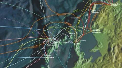
SubTel Forum’s Map Selected For NewBook
Submarine Telecoms Forum magazine announced the selection of its 2004 Cable Systems Map for use in Understanding Fiber Optics by Jeff Hecht, published by Prentice Hall, due for release in 2005. www.subtelforum.com/NewsNow/ 5_september_2004.htm
TampNett to Install Cable Between Platforms
TampNett company is to lay a new cable between the Grane and Oseberg platforms in the North Sea.
www.subtelforum.com/NewsNow/ 25_july_2004.htm
TeliaSonera Gains Full Ownership of Lithuanian Carrier
TeliaSonera has agreement with the Kazickas family to acquire their 10% holding in UAB Omnitel.
www.subtelforum.com/NewsNow/ 15_august_2004.htm
Tiscali Picks Level 3
Level 3 has agreements to supply optical wavelength services to Tiscali International Network BV,. www.subtelforum.com/NewsNow/ 1_august_2004.htm
TYCO Telecom To Provide High-Bandwidth Circuits To Japan Telecom
Tyco Telecommunications recently announced a multi-million dollar contract to provide several high bandwidth circuits to Japan Telecom (JT).
www.subtelforum.com/NewsNow/ 15_august_2004.htm
VSNL Gains US Common Carrier License
The Tata managed Videsh Sanchar Nigam Limited (VSNL) has announced that its U.S. affiliate, VSNL America Inc., has received notice from the Federal Communications Commission (FCC) of the granting of an International Common Carrier 214 License.
www.subtelforum.com/NewsNow/ 5_september_2004.htm
WFN Awarded Oil & Gas Telecoms Support Contract
WFN Strategies was awarded a contract for the provision of strategy and engineering support services for a major multi-national oil company.
www.subtelforum.com/NewsNow/ 5_september_2004.htm
The Calendar
Submarine Telecoms Forum is seeking like-minded sponsors to contribute their corporate images to the 2005 Submarine Cable Industry Calendar.
The 2005 Submarine Cable Industry calendar will be provided free of charge to Submarine Telecoms Forum’s subscriber list, encompassing some 5000+ readers from 85 countries, including senior government and international organization officials, telecom company executives and team, support and supply company management, and technical, sales and
purchasing staff, field and shipboard personnel, academicians, consultants, financiers, and legal specialists.
The Submarine Telecoms Forum industry calendar will be printed in full colour on high quality 200gsm silk art paper, approx 600 x 300mm, giving sponsors an area of approx 300 x 300mm to display their corporate image.
For further information, sponsorship costs, reservations and information contact: Tel: +1 (703) 444 2527 Fax: +1 (703) 444 3047
Email: 2005calendar@subtelforum.com
Emails to the Editor
Best of luck to you with future issues, and congratulations on SubTel Forum gaining a world leader position as a global informative newsletter in the telecoms arena.
Just one negative comment, some of those pesky critter cable ship data’s are woefully out of date.
Bill Petrie, TL Geohydrographics
Being “retired” (ex Telstra/NDC) from the shrunken industry, I have not responded to your reader survey. I assume, however, that you must have a significant retired but still interested following. Also, I enjoyed “Le Tour”; lots of Australian content!
Finally, and apologies for being the pedant, but your editorial page still refers to SubTelForum as being published quarterly despite the switch to bi-monthly last year.
Peter Mills
Submarine Telecoms Industry SURVEY
Many thanks to those who responded to our STF/SubOptic co-sponsored industry survey. Congratulations to Don Benton of Geographic Networks Affiliates –International of USA, our lucky winner of the laminated 2004 edition of the International Submarine Cable Systems map, developed by Submarine Telecoms Forum in conjunction with T Soja and Associates, and presents the industry’s first comprehensive worldwide systems map in over three tumultuous years.
1.Which best describes you?
• Academic
• Engineer/Project Management
• Management – 75%
• Marketing – 25%
• Other
2.What best describes your business
• Cable owner – 25%
• System Integrator – 25%
• Cable Installer/Maintainer – 25%
• Marine Surveyor – 25%
• Other
6.Did you attend SubOptic 2004?
• Yes – 75%
• No – 25%
7.What did you find the most stimulating and relevant topic to be discussed at a SubOptic 2004?
COMMENTS:
• The future and how we tackle the market
• Where the market restructuring is likely going
• Several technical papers (Use of GIS, etc.)
8.If you did not attend SubOptic 2004, why, and do you have any thoughts on what would change your mind for SubOptic 2007?
COMMENTS:
• Industry needs to improve with more “real/substantial” activities
9.Are business conditions improving or getting worse?
• Improving – 75%
• Worse – 25%
COMMENTS:
• Harsh competition
• Ridiculously low bidders
• Still confined to specific markets that justify a solid business plan
• Improving, but only very slightly
10.Are you optimistic or pessimistic about the future?
• Optimistic – 50%
• Pessimistic – 50%
• Other
11.Does your current business performance indicate that we are still in an industry recession?
COMMENTS:
• Yes, definitely
• Starting to see signs of improvement
• All the industry gatherings are not helpful as was once the case (PTC, SubOptic, Telecom GTM)
12.How have client requirements changed over the last three years?
COMMENTS:
• Less care to technical concerns
• Emphasis on getting low bids is primary concern
• Client requirements are still changing (e.g., VOIP, WiFi, etc.)
• Usage profiles and business models are not well understood
• We still don’t have much new system business, but more repairs
• We’re still competing for work, but there are fewer opportunities
• Will there be any competitors left?
13.How has the type of project you handle changed over the last 3 years?
COMMENTS:
• Nothing except price
• There is significantly less credibility in the ITC industry
• We’ll take on any type of work
• We are more flexible in how the contract is written
14.In your opinion, what does the industry most need?
COMMENTS:
• Be realistic and professional, not a crazy run to low prices/war
• Stability so that e can start seeing the “forest from the trees”
• More work, and that “killer application” that requires big increases in bandwidth!
3.How do you rate the content of Submarine Telecoms Forum
• Excellent – 75%
• Good – 25%
• Satisfactory
• Unsatisfactory
• Poor
4.How do you rate the content of News-Now and the STF website?
• Excellent – 50%
• Good – 25%
• Satisfactory – 25%
• Unsatisfactory
• Poor
5.Would you like to see any particular changes in Submarine Telecoms Forum or News-Now, or other website informational services?
COMMENTS:
• Need for more information on future projects
• More information on News-Now, even if some is not exact.
• Good rumors are okay.
• Active hyperlinks in News-Now making story easier to view
EXECUTIVE FORUM
Olav Harald Nordgard TampNett AS
Olav Harald Nordgard is a Special Advisor at TampNett AS in Stavanger. TampNett is owned by Statoil, and operates a fibre cable communication network in the Norwegian sector of the northern North Sea.
Mr. Nordgard is a graduate in Control System Sciences from the University of Trondheim, and has an M.Sc. from the University of Minnesota. He headed the Control Systems Group at NEBB for 10 Years. He worked for 6 years as head of Telematics at the Norwegian National Power Company, and 4 years as head of the same department at the Norwegian National Grid Company. He was instrumental in establishing several North Sea off-shore fibre cable systems. He also headed the strategy group of the international electric energy sector, CIGRE, on commercialization of the telecom sector.
It is generally anticipated that improved ways of operating oil and gas platforms will come into use over the next years. These improved ways of operation will require much higher communication capabilities than earlier. Furthermore, this development will significantly increase the dependency on the proper functioning of the installed technical systems, which in turn will result in strong requirements to the availability of the communication systems.
Benefits
Provision of high capacity and very reliable communication solutions between offshore and onshore may bring a number of benefits, ie:
• Full integration of off-shore and onshore IT support systems
• Moving tasks from off-shore to onshore
• Providing on-shore based competence to off-shore locations, without flying the expertise there
• Moving off-shore generated information to on-shore for data processing, and returning processed data to offshore Effects of moving tasks to shore could be:
• Some personnel may be moved onshore
• Better safety due to less personnel offshore and less personnel transported by helicopters
• Cost reduction
• Extending the field life by improving the profitability of offshore installations further into the tail of the production period
Moving onshore based competence on-line to the offshore installations, such as for instance the transfer of pictures/video of objects/ materials that needs to be investigated from offshore to experts onshore, rather than moving the experts offshore, resulting in:
• Access to experts that may be located far away.
• Quicker analysis of a situation.
• Better utilization of available expertise. Moving data on-line from the platforms offshore to on-shore for data processing and evaluation, allowing for instance:
• Continous analysis of geological models while the drilling is ongoing, possibly giving better hits in the hydrocarbon bearing layers.
• Continous analysis of the reservoir models while the production takes place, possibly giving a better drainage of the reservoir
Current types of high capacity applications
As high capacity communication has become available to a number of offshore installations in the North Sea, there has been a stepwise increase in the application of such capacity.
An early effect was to move servers from the platforms to shore, to facilitate the integration of the IT support systems offshore and onshore. Another one was the introduction of high quality video conference systems, improving person to person communication between offshore and onshore. Still another type of application that to some extent has been taken into use is to move pictures of objects from offshore to onshore for fault analysis by experts onshore, rather than moving the experts offshore. For this purpose there has been developed hand held equipment that can be move around on the platforms.
Common to these types of applications is that they are not critical to the actual offshore operations, and could be implemented even with limited resilience in the communication network.
Currently there is a considerable focus in a number of oil companies to establish onshore drilling support centres, where experts from different disciplines relevant to the drilling process are present. These experts can evaluate real time information processed by on-shore computers, to plan and assist during the drilling process. Benefits here may be reduced rig time and better “hits” in the hydrocarbon bearing layers.
Eventually it is also assumed that some control tasks will be performed from onshore centres, reducing operational costs. This will be
especially important during the tail production period. Clearly such a development will put stringent requirements to the availability, security and quality of the communication network.
To support these applications, the North Sea will in the future have a significant high capacity, high quality, communication network.
The offshore communication network structure
The communication challenge to the platforms in the central and northern North Sea is the distances to shore. These distances are so large that they effectively block the use of high capacity radio links to shore. However, these platforms are often located in clusters, allowing high capacity radio links between the platforms in the cluster.
Up until the last few years this has resulted in a network structure where the communication to shore has been done via satellite, and the communication between the local platforms goes via radio links, and in some instances via local fibre.
Satellite communication is expensive, relatively low capacity and due to the distance to the satellite, it has a time delay that limits some technical application capabilities.
The fibre optic cable technology however, allows high capacity communication over long distances, more than 300 km. However, it is
expensive to install and to pull into platforms. Consequently, the offshore network structure in the future will consist of a fibre backbone network to solve the “long distance – high capacity” problem. This backbone network will only be connected to a few key platforms. The remaining platforms will be connected to the key platforms via access networks, which could be high capacity radio link systems.
The networks will be ring structured to meet the high availability requirement caused by the improved ways of operation. This is illustrated in Fig.1 on the next page.
The formation of an integrated, resilient, “one-stop shopping” offshore network
Over the last few years several offshore fibre cable systems have been installed in the central and northern North Sea. All are radials, and all have different owners.
In May 2004, the owners of the different backbone fibre cable systems in the Norwegian sector of the central and northern North Sea entered into agreements to integrate the different cables into one network. The ownership of the different cables still remains with the original owners.
This integrated network is scheduled to be operational by 01.10.2004, and will be operated by one operator, TampNett. This will enable “one-stop-shopping” provision of network solutions across ownership borders. It
will further enable the monitoring and control of the whole network from one control centre.
As a part of this agreement TampNett is installing a new fibre cable system connecting the current radials, and thus forming a resilient offshore backbone fibre network.
Serving new platforms
The integrated fibre cable network operated by TampNett is close to the UK sector border in some areas. As a result of this, a number of
platforms in the UK sector to the west of the Sleipner – Heimdal area, and to the west of the Tampen area, are within the reach of high capacity radio link systems.
In the area west of Tampen, nine Shell Expro operated platforms were connected to the TampNett fibre cable system on 1st September 2003.
Fig. 2 shows the integrated backbone fibre network (red), with existing and planned associated high capacity radio link network (blue).
TampNett
TampNett AS is a registered limited company owned 100% by Statoil, established in January 2002.
The TampNett business idea is to be an offshore telecom network transport provider, serving the central and northern North Sea. TampNett is currently serving 28 platforms in the Norwegian and UK sector, both directly via fibre and indirectly via established high capacity radio links.
After the completion of the new fibre cable system Grane – Heimdal – Oseberg, and the formation of the integrated network, the number of served platforms will increase.
Fig. 1 Ring structured network
Fig. 2
Nobody Said It Was Easy . . .
Comprehensive Telecom Solutions for Remote Oil & Gas Applications
Guy Arnos, Wayne Nielsen, Steven Wells
With endlessly increasing demands on the world’s oil and gas fields, it is becoming a necessity to have both secure and reliable data and telecom connectivity with them. Add to this the growing bandwidth demands for remote monitoring, reservoir optimization, video surveillance, and a host of other applications and it is easy to understand why current systems are groaning under the strain.
The solution is not always as obvious as it might at first appear, and each field will need a bespoke solution. After all, there is a limit to how many microwave dishes can be mounted in the correct attitude, subsea cables offer huge capacity but can be vulnerable to external damage, and satellite capacity remains heinously expensive.
Whatever the solution, it has to be a solution not for just today and tomorrow, but for the next 10 years or so. It must be resilient, maintainable and up-gradable and life cycle costs need to be considered rather than just build costs.
Network redundancy should be built in using the most appropriate local solution. Existing network pinch points need to be examined and eliminated. Permitting and licensing issues will need to be addressed. Back-up solutions and their limitations will need to be identified. Ongoing maintenance solutions will have to be defined. In-field communication requirements will have to be assessed and served With such a cornucopia of requirements, demands and technical issues to consider, it is easy to understand why the subject is often put
“on-hold”. After all, hydrocarbon fields are there to pump oil and gas, and not to operate as a telephone exchange.
Not only is it important to appreciate what is on offer, but also why a remote, third party view is often required to see a way forward.
Technical Options to Consider
Submarine fiber
Submarine fiber optic cables are much the same as inter-platform communication cables. They are physical cables laid on or under the seabed and consist of strands of pure glass little larger than a human hair enclosed in a cable which affords physical protection from the elements. Fiber optic cables extend to much longer distances without amplification than their
predecessors, copper cables, and can carry orders of magnitude more traffic. The only real issue that differs from conventional oceanic subsea cable laying is the physical connection to the platform(s). Fiber cable connections to the platforms will always be secondary to those required for oil, gas and water injection. Further, where the riser cables are connected to a floating platform the cables will have a unique requirement to absorb wave and tidal motion.
Microwave & Tropo-Scatter
Microwave dishes are a relatively common sight on offshore platforms as they offer rapid connectivity for reasonable capacity demands. Transmission frequencies are from 2 to 25 GHz, with the higher frequencies used in short-haul private networks. Microwave transmission is useful when cable is difficult or impractical to use and a straight line of sight is available between two points.
Higher bandwidths are susceptible to weather conditions such as rain and fog because the shorter wavelengths are more easily absorbed by water. Decreasing the distance helps. The reliable range of the STM-4 links is somewhat less than the range of the lower-capacity technologies and an STM-4 hop length of less than 40km is a current planning guideline example.
Paths over water or other reflective surfaces like ice require height-diverse antennae to
avoid fading due to reflections from the reflective surface. Careful control of power levels and antenna overspill areas allows frequencies to be re-used within a single network, easing radio spectrum demands and licensing requirements.
In oilfield applications, it occasionally becomes necessary to operate microwave systems beyond the usual limits of line-of sight distance. This is essentially a brute-force solu-
tion in that a high-powered transmitter sends a narrow beam to its horizon, and illuminates a region which is within line-of-sight of the receiving station.
A high-gain receiving antenna can receive a signal refracted by the scatter region. Relying as it does on atmospheric turbulence and perturbations for scatter, the mechanism is weak and subject to considerable fading, requiring
multiple diversity techniques to obtain a useful service, however a range of several hundreds of kilometers is possible in the humid tropical regions such as the Caribbean.
Radio
Ubiquitous on and around platforms and oil fields but limited in range and capacity, mobile radio is the day to day workhorse of oil field operations communications. Mobile radio and paging provide critical local communications for the safe and efficient operation of production facilities. To be highly effective, mobile radio is dependent on other technologies for the backhaul and trunking required for modern digital trunked radio or cellular solutions. Demand for frequency spectrum is putting tougher demands on mobile radio operators to squeeze more channels out of existing frequency allocations. In some cases regulatory bodies are mandating the reduction of channel frequency width and consequent upgrade or replacement of mobile radio equipment. Further pressure comes from the demands of commercial PCS, GSM and other 3G cellular operators for increased spectrum and the reallocation of some industrial frequency bands for these purposes.
Satellite
Satellite dishes are also fairly frequently seen on offshore platforms as they offer communi-
cations, without physical links, over any range, but at a price.
Satellite communication systems receive and transmit signals between earth-based stations and space satellites. There are “high-orbit” geosynchronous satellites, LEO (low earth orbit) satellites, and satellites in a variety of midorbits. Geosynchronous satellites are placed in high stationary orbits 22,300 miles above the earth, where they receive “uplink” signals from earth-based transmitters (or other satellites) and downlink those signals to earth.
The downlink covers an area called the footprint, which may be very large or cover a focused area. The geosynchronous orbit is ideal because the satellites stay synchronized above a specific location. However, there are only so many slots in this orbit, and all the slots are taken above the most populated areas of the earth.
One problem with high-orbit geosynchronous satellites is that a typical backand-forth transmission has a delay of about a half second, which causes problems in timecritical computer data transmissions. There are a number of applications for using satellites in data communications, but the time delays and low transmission rates must be considered. Some applications include videoconferencing, non delay-sensitive data transmissions, and temporary backup links.
Cellular
Cellular technologies and services are potentially useful for day-to-day oil field communications. Unfortunately, most oil fields and platforms are in remote and/or sparsely populated areas either too far from coverage or economically untenable for commercial operators. If cellular technology is attractive, field operators must often consider a private system which has attendant problems of spectrum licensing where frequencies may have been auctioned to commercial telecom
operators. In the face of these barriers, focus often returns to private mobile trunked radio systems.
Impacting Issues
Aging Equipment
In the case of mature fields or platforms, telecom infrastructures are usually old, sometimes obsolete and invariably a “hotch potch” of individual systems, which have been added together over time without integration. In some instances this agglomeration of systems comes about due to mergers and acquisitions among partners in an exploration or production area. Many times it is simply a case of incremental communication needs being addressed one at a time as they arise over many years without any strategic telecom planning. As noted before, the core business of the operating entity is oil and/or gas production, not the operation of a telecom network and priorities are apportioned accordingly. Aging systems still work, so the impetus to upgrade or replace them is low unless someone assesses potential productivity gains that new technologies may bring to the production of energy. What often seems to be overlooked when communication services are inevitably given second priority is that telecom and telemetry systems support mission critical functions in the production arena, and failure of those systems can stop or severely curtail production from a single well, a group of wells or an entire field.
CapEx and OpEx
Capital and Operational expenses must be considered in terms of life cycle costs including maintenance, backup facilities, upgrades and replacements. Telecom infrastructure capital and operational budgets often come under intense scrutiny out of proportion to the percentage that these budgets may represent of the overall capital projects or operational budgets involved. Because of this scrutiny budgeting must be accurate and as inclusive of all potential capital and operating costs as possible. Poorly budgeted projects are subject to chronic cost overruns which exacerbate the problem of quality telecom assets being perceived as necessary evils or luxuries.
Implementation Schedule
Implementation schedules must be carefully examined to ensure that telecom infrastructure is in place to meet operational needs. Equipment lead times must be considered as well as construction time frames. Certain specialized
systems such as undersea cables may require time consuming seabed surveys, environmental permits and seabed easements unfamiliar to the oil field operator. In other areas frequency licensing may be extremely difficult and lie on the critical path. In some exotic climates, construction maybe limited to specific narrow windows for environmental and/or logistical reasons.
Survivability, Redundancy and Single Points of Failure
Network survivability is crucial where remote telemetry and control systems are deployed. Failure of process control networks for only seconds may result in production interruptions or slowdowns. Communication failure may also compromise personnel safety, particularly in hazardous environments, emergency situations and harsh climates. Survivability is a function of eliminating single points of network failure and implementing network redundancies. Budgetary constraints or priorities often conflict with redundancy requirements and the impact of production inefficiencies must be weighed against the cost of network survivability and the mean time to repair.
Strategic Planning and End User Bandwidth Requirements
To prevent the problems seen with “evolved” systems, it is important to look strategically at
telecom requirements for the operation. This strategic evaluation should consider current needs as well as future requirements.
Current needs should be reviewed against end user bandwidth requirements. End user bandwidth demands are always varied, diverse and ever expanding. From the simplest telex channel which can operate quite happily on a radio link, to the most sophisticated remote control and monitoring functions, which consume huge bandwidth, there are a multitude of applications and processes which need to be served.
Identifying each of these tasks and the demands they have on a communication network is a challenge. Links are often “taken for granted” and it is only when they are added together that the impact on bandwidth is identified.
Future requirements should allow for advances foreseen in both telecommunications and production technology as well as any potential requirements for remote operation of assets to improve productivity and efficiency. The analysis should consider upgradeability and examine the benefits of extra capacity against the additional capital costs.
Operational Risks
The operational risks to telecom systems must also be considered and evaluated. For
terrestrial cable systems the risk of cable damage in either buried or aerial placement should be examined against future expected construction or excavation and/or weather. For submarine cable systems, the risk of cable damage due to fishing activities, ship anchoring, chafing or sea bed seismic activity must be considered.
For microwave systems, weather conditions such as heavy rain, cold temperatures or thermal inversions and other path conditions must be taken into account.
System Engineering and Design Efforts
A telecom system architecture and design must be developed from all the data, considerations and requirements assembled from the steps above. The development of the plan should include a review of telecom technologies, costs and integration issues. Systems may include fixed land-based systems, undersea systems, nomadic systems for such applications as roving drill rigs as well as mobile voice and data applications.
An overall network architecture and system design will form the basis for an effective economic model of the system.
Analysis for Network Model and Budget Model
Once the system architecture and design are complete the network may be modeled and the capital budget developed. A well-constructed
Guy Arnos has over 20 years experience in submarine and terrestrial networks. He has been responsible for planning, engineering and implementation of transcontinental and metropolitan networks. He supported provision and installation of a multi-submarine cable system in the Gulf of Mexico, and provision and installation of a fiber optic, RF, microwave and cellular system in Alaska. He joined in WFN Strategies in 2001 as Senior Consultant. Wayne Nielsen has over 20 years of submarine cable experience, and has managed international telecom projects worldwide. He has been responsible for planning and implementation of global business strategies and engineering of submarine telecoms networks. In 2001, he founded WFN Strategies, providing telecom, oil & gas and defense customers with business and engineering solutions. He is publisher of Submarine Telecoms Forum .
Steve Wells has worked in R&D for submarine systems for over 30 years, and was a key engineer in burial technology, optical repeater terminations, optical jointing and optical fiber packaging. He was Head of Ops for marine engineering at BT, responsible for European and Far Eastern permits. He was also Director of Global Fiber Networks at PricewaterhouseCoopers. He is a founding director of Datawave Ltd and Managing Director of WFN Strategies (Europe).
budget model will allow a variety of “what if” scenarios to be quickly and easily considered by identifying and altering key assumptions parametrically. The model should include operating cost estimates as well as capital costs so life cycle cost analysis may be performed.
Business Case Modeling
In addition to basic cost modeling, some operators may wish to consider different acquisition and/or operational strategies in addition to conventional “buy, build and operate.”
These strategies might include lease, leaseback, third party outsourcing of services over dedicated facilities or other creative and unconventional scenarios. Any of these business options should be compared on a present value basis considering all life cycle costs.
Final Report cooperatively drafted with client Ultimately, the results of all the data gathering and analysis must be tabulated, conclusions drawn with recommendations made and reported. Involvement of the client with the analytical process and the drafting of the report will result in the best chances of success for the effort.
Reports can be written with due regard to client sensitivities while preserving the integrity of the data, results and recommendations.
Desired Effort Results
The end result of the process should be a well planned telecom system which is well integrated with the oil and/or gas field or platform operations. The system must be designed to be cost effective and to seamlessly enhance the safety and efficiency of the production operation.
Conclusion
A remote, third party view is often what is required to see a way forward for several reasons, including:
• Sufficient breadth and depth of telecom expertise does not exist within an oil/and or gas company
• Many of the operational personnel are too close to the situation to look objectively at technology and costs
• Company staff have too many other priorities to be able to complete a comprehensive integrated review in a timely fashion, and
• Almost all oil and/or gas fields are owned and/or operated by consortia or partnerships of multiple operators. In this scenario, an independent third party’s review may be perceived to be more objective with less “self interest” by the other owners or operators involved.
For more information contact reprints@subtelforum.com.
Nexans Norway AS P.O Box 6450 Etterstad, N-0605, Oslo Norway
Tel: + 47 22 88 61 00
Fax: + 47 22 88 61 01
US Contact: Les Valentine
Tel. +1 281 578 6900
Fax: +1 281 578 6991
E-mail: les.valentine@nexans.com
Globalexpertincables andcablingsystems exans
HIGH FIBRE DIET
A high count fibre submarine cable family with extension of unrepeatered transmission span lengths
During the recent years there has been an increased demand for high fibre count in both terrestrial and submarine cables, especially in coastal applications as part of a terrestrial network. This requires high fibre count in submarine cables, together with a demand for G655 fibre types to cover future bit rate upgrades.
The submarine cable development has been accompanied by the development of designated cable joints and equipment for remote amplification.
DESIGN OBJECTIVES
The main design objective for the high fibre count sub sea cables has been to provide a family (URC-1 family) of reliable and cost effective cable designs suitable for both present and future fibre types. Hence, the cables developed provide excellent physical protection of the fibres with very low stresses and environmental impacts on the fibre during all service conditions (/1/-/6/).
by Vegard Briggar Larsen
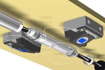
A branching unit (BU) and cable joint boxes have been developed and qualified for 2000m sea depth. The BU, which splits the fibre count between single and double legs is for example used in transmission links between oil platforms in order to pull in and hang off one submarine cable instead of two.
CABLE DESIGN
Optical Package
The optical package presented in Figure 1 is based on the steel tube technology in which the fibres are protected inside a jelly filled, laser welded stainless steel tube. The cable core consists of up to eight SZ stranded, 3.7 mm OD, steel tubes, each with a capacity of 48 fibres. Thus, up to 384 fibres can be accommodated. The fibres in each tube are uniquely colour coded.
The single tube configuration can also accommodate up to 96 fibres, in a 5.6 mm OD steel tube. Furthermore, the single tube configuration can be fitted with a smaller tube (j 2.3 mm) for deep sea installations.
Optical testing during manufacturing and qualification have clearly shown that the stainless steel tube provides a stable and reliable environment for the fibres over the whole optical bandwith. This has been demonstrated for standard single mode fibres (G.652), G.654 as
well as for the new fibre types (G.655) with larger effective areas and reduced chromatic dispersion slope to accommodate higher number of wavelengths for the new submarine “highways”
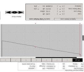
In Figure 2, cabled attenuation for a 25km trial cable length with large effective area fibres (G.654) is shown, with 0.162dB/km @ 1550nm.
Cable Core and Armouring
For mechanical protection and electrical insulation a polyethylene sheath is applied over the steel tube(s). For electroding and fault finding purposes, copper conductors are integrated in the interstices between the tubes in the multi tube designs. For the single tube design a copper tape applied over the steel tube ensures electrical continuity.
Figure 2. OTDR trace showing 0.162 dB/kmcabled attenuation for test cable.
The overall diameter of the cable core is 10 mm, 16 mm or 20 mm for the single tube, four tubes and eight tube configurations respectively.
The cable core is armoured with galvanized steel wires. All steel wires are preformed in order to provide more uniform coverage, better handling and installation characteristics, and facilitate termination work.
A double layer of polypropylene yarn (as shown in Figure 2) or high density polyethylene jacketing is available for outer protection.
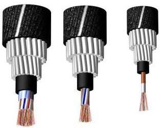
Figure 3. URC-1 cable with 96 to 384 fibres.
A complete range of cables; single armour (SA) and double armour (DA) designs offering tensile strengths from 5 to 400 kN has been qualified (/8/). Typical DA designs are shown in Figure 3. The main cable characteristics for the designs are shown in Table 1.
Max fibre count 48/96192/384
Operating temp. range (°C)-20 - +35
*) Nominal Transient Tensile Strength, 1 hour
Table 1. Cable characteristics. Single armour (SA) and double armour (DA) cable designs
CABLE ACCESSORIES
Joints and Branching Units
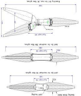
The development of high-count fibre cables has been followed by the development and qualification of a family of Joint Boxes and Branching Units (BU). General design and dimensions are shown in Figure 4.
The branching unit and the joints are designed and tested for 3 m bending diameter, and can be deployed using standard cable installation procedures and equipment. The units are
designed and tested for electrical continuity and insulation from the seawater, which is required for cable electroding and fault finding purposes.
Joints and BU assembly principles are based on mechanical terminating the cable ends followed by fibre jointing before the sea-case closure is installed.
The assembly time for a 384 fibre joint box is shown below.
• Mechanical assembly and fibre splicing: 24 hrs
• Prepare cable ends and assemble armour termination: 2 x 2 hrs
• Fibre bracket assembly: 2 hrs
• Fibre splicing: 16 hrs (24 fibres/hour)
• Final assembly: 2 hrs
• Optical verification: 16 hrs (24 fibres/ hour)
The jointing time is based upon the following manpower:
Cable End A: 2 optical testers
Cable End B: 2 optical testers
Jointing area: 2 jointers.The jointing time could be further reduced by increasing the manpower, especially during final optical verification.
Remote Amplifier Box
The Remote Amplifier Box (RAB) amplifies the optical signal in un-repeatered submarine fibre cables. The technology relies on passive optical components, which are optically pumped from a land terminal.
The amplification increases the repeaterless transmission link distance from typically 220 km to 300 km.
Figure 4. Joint boxes for 96 and 192/384-fibre splices and BU.
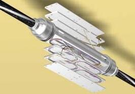
Figure 5. 384 fibres joint box. (Two bend restrictors and outer sea case not shown).
Figure 6. Fibre splicing principles with two jointers working in parallel with fibre splicing.
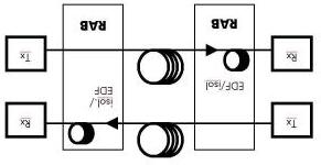
Figure 7 depicts the optical topography for one fibre pair. An Erbium Doped Fibre (EDF) of typically 25 m length and an optical isolator provide the signal amplification. The unit can presently accommodate up to 96 such fibre pairs, implying up to 192 optical fibres.
The EDF is pumped at 1480 nm from the receiver terminal. One fibre is utilised for both pumping and the amplified signal. For the shown pre-amplification single pumping configuration, a budget improvement of typically 15 dB is feasible. Signal transmission is at typically 1520 nm wavelength.
The RAB relies solely on passive optical components, with pump lasers and control circuitry located in the land station. The system thus maintains the high reliability, low cost and simplicity characterizing un-repeatered systems.
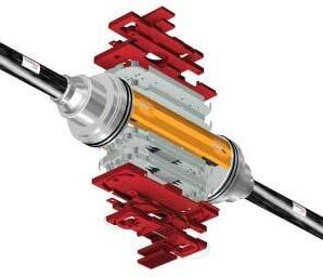
The RAB (Figure 8) is designed to protect the optical components and the fibre splices from the mechanical loads arising in transportation, in-
stallation and long term operation. Special attention has been dedicated to hydrogen protection, to which Erbium Doped Fibre is sensitive.
Mechanical termination of the sea cable is accomplished utilising a hydraulically activated cone system. Pressure integrity and minimum hydrogen ingress rely on metal-metal seals and standard compression fittings to the fibre steel tubes. The design permits easy adaptation to all Nexans sea cables.
tective sleeves, together with fibre service lengths, are secured in dedicated trays.
RAB provides electrical isolation from seawater and continuity through the transmission link, as required for cable electroding purposes.
The 48 fibre pair RAB has overall length 480 mm. Outer diameter is 143 mm. Including bend limiters yields corresponding dimensions 1700 mm by 216 mm. Total weight including bend limiters is approximately 75 kg.
RAB is incorporated within the cable transmission system prior to installation and is deployed using standard cable installation procedures and equipment.
Sealing of sea casing.
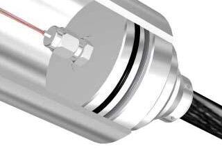
The branching unit , the joint boxes and the Remote Amplifier Box all rely on metal-metal sealing technology. The concept is shown in Figure 9. The primary and secondary seals to the
Cylindrical outer housing and two bend restrictors have been omitted for clarity
The optical components (isolators and Erbium Doped Fibre) are secured on aluminium trays, in turn mounted on a central axial bracket. All fusion fibre splices and their pro-
Figure 9. Sealing Principles
Figure 7. Optical Topography for one transmission channel (one fibre pair shown).
Figure 8. RAB exploded view (48 fibre pairs).
outer sea casing comprise a metal C-ring and an elastomeric O-ring respectively. The materials have been choosen for long term sea water exposure. The cable steel tube is sealed using a standard metal-metal compression fitting, which in turn is mounted in a ceramic insert for electric insulation from the sea water.
Lloyd’s Register
- Fairplay making available, complimentary to subscribers, comprehensive databases of commercial vessels (www.sea-web.org/), ports and companies (www.portguide.com). In order to qualify for a free trial of these services, contact LRFTrialOffer@SubTelForum.com.
The Erbium doped fibre in the RAB is particularly sensitive to hydrogen, which is generated in the sub-sea plant corrosion process. The metal-metal seals offer efficient and reliable hydrogen diffusion barriers.
Requirements
This system configuration has been designed on the basis of the following data:
Description for 550 km LinkLinkUnits
Data transmission rate per channel STM-16
Link length550km
Fiber descriptionG.654
Cable attenuation (including splices) 0.160 dB/km
Aging and Repair margin5dB
Ultra long haul transmission span length Nexans is providing the following proposal for a 550km link. The basic link capacity is 2.5 Gb/s (STM-16) per fibre pair.
This link requires a combination of Remote Optically Pumped Amplifiers (ROPA).
A particular feature of the proposed solution for a very long link is that the submarine cable will need a different number of fibres, depending on the section being considered.
The additional fibres at the two ends of the submarine cable are used to provide additional pump power to the ROPA elements, and hence to increase the total reach.
Nexans’ proposed solutions for the terminal equipment are described on a per fibre pair ba sis.
Maximum fibre dispersion, G.654 fibre 20ps/nm-km
ROPA pump attenuation (1480 nm) for G.654 fibre 0.205 dB/km
Technical solution
The solution proposed relies on using long-haul OLE equipment with the addition of two ROPAs in each direction of transmission. One ROPA is located near the transmitter (the Transmit ROPA) and the other near the receiver (the Receive ROPA).
Optical budget
The table on the following page details the optical power budget throughout the link. has entered into an arrangement with
Available optical budget (for reference only) 102,8dB
Tx ROPA position (from transmitter)65km
Middle span length300km
Rx ROPA position (from receiver)125km
Dispersion limit of receiver 4500 ps/nm
Required dispersion compensation (see note) 7500 ps/nm
Notes to previous table:
•The Rx ROPA position is that for a doubly pumped ROPA. The second pump must be delivered to the ROPA using a separate fibre. The Tx ROPA requires separate pumping fibres.
•The receiver’s sensitivity is the effective receiver sensitivity when used with a low-noise EDFA preamplifier and in the absence of other error sources.
•The FEC gain of 5.5 dB cannot be measured separately from the other parameters while in the system since the sensitivity point is approached at multiple locations.
•The calculated available optical budget is obtained by adding the following: the launch power, the Tx ROPA gain, the Rx ROPA gain, the Raman gain in the receive span, the effective receiver sensitivity with the optical preamplifier, and the FEC contribution. From this, we remove noise contribution from the Rx ROPA and from the pre-amplifier.
•The dispersion compensation value represents the minimum amount of dispersion compensation that must be provided for the system to provide the optimum performance. The dispersion compensation will be divided between the transmitting end and the receiving end of the link. The position of the dispersion compensation is chosen to have no effect on the optical budget (i.e. it is placed before the EDFA booster or after the EDFA pre-amplifier).
The solution proposed relies on using long-haul OLE equipment with the addition of two ROPAs in each direction of transmission. One ROPA is located near the transmitter (the Transmit ROPA)
Straight Line Diagram for 550km Link
and the other near the receiver (the Receive ROPA). The following diagram illustrates the relative position of the elements in the system, especially the additional pumping fibres that are required. Since the relative positions of the Transmit ROPA and of the Receive ROPA do not coincide, there will be a total of four ROPA housings in the system.
QUALIFICATION
The family of high count fibre cables, the joint boxes and the BU have been successfully qualified for the loads associated with manufacturing, transportation, installation and operation. The RAB qualification tests are summarised in table 2. The entire cable family up to 384 fibres with associated joint boxes, has been qualified accordingly (Figure 10).
He leak testingLeak rate better than 10-8 cm3/s. (Room temp)
Table 2. Qualification Tests.
INSTALLED SYSTEMS
A high number of sea cables of the described design has been successfully installed and operated. These installations include more than 8000 km cable, with up to 48 fibres. Among the
Vegard Briggar Larsen graduated from the University of Salford, England in 1991 with a BEng degree with honours in Electronics. He spent 2 years doing reasearch in thin superconducting films at the University of Technology and Science, Trondheim Norway, before joining Alcatel Kabel Norge, (now Nexans Norway), in 1997 as a project engineer mainly responsible for development and qualification tasks.
installations are the Ireland-UK Crossing System (245 km and 267 km, 24 fibres) and “Nor Sea Com 1” (740 km total system length, 260 km longest link length, 24 fibres).
To date, about six commercial cable lengths with 192 fibres have been successfully manufactured, tested and installed. Pre- and post installation measurements carried out on 192 fibres cables show only minor differences in optical attenuation, all within 0.200 dB/km at 1550 nm.
The “Level-3” project (England–Belgium crossing, 121 km, 192 fibres) exhibited average pre- and post installation loss 0.190 dB/km and 0.197 dB/km respectively. The loss variation is attributed to the number of installation joints.
A field trial on the installed Level-3 cable successfully demonstrated 32 channels at 40
He was appointed Marketing Manager in 2002 from former position as Product Manager of Telecom cables manufactured at Nexans Norway’s Rognan plant.
Gbit/s /7/. Hence, demonstrating a potential upgrade to 122 Tbit/s for the installed 192 fibre cable.
To date, one commercial cable length (15 km) with 384 fibres have been successfully manufactured, tested and installed across the Oslo fjord in Norway for “Song Networks” as shown in Figures 11 and 12. This length was provided with 288 off G.652 and 96 off G.655 fibres. The length was manufactured and installed without any joint boxes. However, a joint box was qualified and available under the installation.
Figure 10: Tensile testing of the 384 fibre cable and joint box at 3 m diameter sheave.
11. Loading
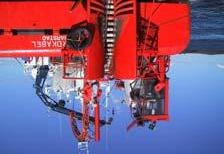
The 384 fibre cable was installed with the C/V Fjordkabel from Bulk Transport AS in Harstad, Norway. The C/V Fjordkabel is a fairly small vessel; 37.4 metres long, 10.3 metres wide, and has a draft of 2.0 metres. However, this did not cause any problems during the
Figure 12. Installation of the 384 fibre cable with the C/V Fjordkabel.
installation as the handling characteristics for the 384 fibre cable turned out to be similar to the cables with lower fibre count.
CONCLUSION
The URC-1 cable family has been developed, qualified and installed for up to 384 fibres. The design has proved cost effective and reliable.
Tests and experience from installed cables have demonstrated the stability of the optical transmission characteristics of the URC-1 submarine cable under all service environments. More than 8000 km URC-1 sea cable have been successfully installed.
Cabling tests have shown that it is possible to make cables with cabled attenuation down to 0.160 dB/km.
Joints and a branching unit have been developed and qualified for 3000 m sea depth.
A Remote Amplifier Box has been developed and qualified for 3000 m sea depth. The unit is pre-installed on the cable and is deployed with normal cable laying techniques. The unit improves the optical budget in optical transmission links by typically 15 dB, corresponding to typically 80 km for the simplest ROPA configuration.
With more advanced ROPA configurations, transmission distances up to 550 km can be achieved, with no eletronics in the transmission line. Thus , the overall reliability and low cost characteristic to un-repeatered systems is maintained, as the unit is electrically passive.
19471 Youngs Cliff Road. Suite 100, Potomac Falls, Virginia 20165, USA
the 384 fibre cable to the installation vessel from rail cars.
OFS innovates today’s major submarine networks with fibers that support longer distances and higher capacities than ever before. The results? Lower system costs and unrivaled performance.
OFS has the optical fiber to support all your emerging system design needs –Lower dispersion management cost
Higher reliability
Greater capacity and bandwidth
To unleash your system’s full capabilities while keeping your costs competitive, choose OFS fiber for your next submarine cable project.
For more information on OFS’ complete family of fibers for the submarine market, please visit the OFS Fiber website at www.ofsoptics.com or call Tom Davis at (973) 655-1502
BRIDGING BRIDGING BRIDGING BRIDGING BRIDGING THE GAP THE GAP THE GAP THE GAP THE GAP
One of CTC Marine Projects’ first steps in bridging the gap from the telecoms industry to the oil and gas industry presented itself through the opportunity to complete The Sleipner to Grane Fibre Optic Cable Network Project for Norddeutsche Seekabelwerke GmbH (NSW). With the end client Norsk Hydro, the project comprised a single, 24 fibre, fibre optic cable linking the Sleipner A (15/ 9) platform and the Grane (25/11) platform on the Norwegian Continental Shelf.
The notice-period given to CTC of one week before mobilisation represented the shortest in CTC’s previous experience, yet mobilisation commenced on schedule on 22nd July 2003. The project comprised two segments; FOC2/ Jumper to Sleipner Target Box (0.682km in length) and Sleipner Target Box to Grane (100.258km in length) crossing one active pipeline and three in-service fibre-optic communications cables along the Sleipner Target Box to Grane segment of the Sleipner to Grane Fibreoptic cable route project. Water depths along the route ranged from 84m at the Sleipner platform to 128m at the Grane platform.
By Natasha Kahn
CTC Marine projects were contracted by NSW to perform simultaneous lay and burial of approximately 103km of cable to a target depth of 1m between the Sleipner and Grane platforms. The installation activities that CTC Marine Projects undertook, used its M/V Skandi Neptune, as Norsk Hydro required a DP2 class
vessel. This was combined with the Rockplough2 - Norsk Hydro wanted to use a plough instead of a trencher - which was deployed from the stern of the Skandi Neptune.
Rockplough2, a 2 nd Generation CTC RockploughTM, proved the plough of choice due to its additional cable engine to reduce residual tension, its cutting disc and jetting system. These enhancements enable the plough to carry out primary burial with high rates of productivity.
Throughout the installation operation, the Quality System used was in compliance with the relevant requirements of ISO 9002 for all activities supporting Project Operations.
In addition, the Safety Management System used was based on the requirements of UK Health and Safety at Work Regulations, adapted, where necessary to suit the requirements of the Norwegian Petroleum Directorates’ NORSOK standards. Project personnel were trained and experienced in Safety and Environmental protection and the Project Manager also ensured that all sub-contractors and suppliers operated to adequate Safety systems.
Cable operations commenced on 29th July when the cable buoy at the Sleipner platform was hooked and brought to deck. On 2nd August, at KP 10.954, the plough was recovered, and freelay operations up to the TAT 14 cable crossing, at KP 44.320, commenced.
Final jointing commenced on 9th August
and was completed on 10th August. Following recovery of the release, the vessel departed the Grane platform.
Assistance from an ROV from the M/V Geobay enabled the bight to be laid on the seabed, and the bridle connection points to be cut, leaving the cable on the seabed. The release bridle was then recovered to deck.
The vessel arrived alongside Tees Offshore Base, Middlesbrough, on 14th August. Demobilisation commenced and all additional equipment, spare cable and additional personnel had departed the vessel on 15th August.
Throughout the loading and laying operations, a single offshore crew was utilised and during all ploughing operations the following key parameters were continuously recorded on the lay data logger:
• Tow tension
• Burial depth
• Plough position
• Cable tension
• Residual tension
• Bellmouth entry angle
This was essential to ensure control of burial depth was maintained by positioning of the skids and hinging of the chassis of the plough; an arrangement which allows for maximum stability of the plough at all depths.
Throughout ploughing operations, the maintenance of the plough and deck handling equipment was optimised where possible to be
Featuring more than 20 key carriers and cable operators in the submarine industry
The 7th annual Submarine Networks World 2004 has grown to be Asia’s most established and well-attended event by the submarine cable community. The senior level conference has evolved into THE "industry event" where cable operators, carriers and technology vendors converge annually.
Our outstanding speaker panel includes:
•Claire Paponneau, France Telecom
•Patrick Gallagher, Flag Telecom
•Bob Woog, Pivotal Telecom
•Kaz (Kazuhiro) Nishihata
NTT Communications Corporation
•Fiona Beck, Southern Cross Cables
•Stefano Mazzitelli, Telecom Italia Sparkle
•Andrew Kwok, Hutchison Global Communications
•Kamran Malik, Saif Group Telecom
•Ian Pulford, British Telecom
•Scott D. White, Azea Networks
Register now! Call our customer service hotline at (65) 6322 2700 today
undersea intelligence
22 – 24 September 2004, Grand Copthorne Hotel, Singapore
timed simultaneously with planned plough recoveries, therefore minimising the amount of surface laid cable along the route.
A key objective during installation of surface laid sections was the achievement of the correct level of slack. The slack was planned, by NSW within their issued RPL, in order to allow the cable to contact the seabed throughout its length, with sufficient excess to allow for operational contingencies, and inaccuracies in supplied survey data.
During the laying of Sleipner-Grane, one existing pipeline and three existing cables were successfully crossed. A crossing agreement was in place between the Client and the owners / operators of each pipeline/cable prior to the M/ V Skandi Neptune commencing lay operations across each. At each crossing the plough was recovered to deck.
On successful completion of the project, Norsk Hydro commented on the professionalism shown by all parties on board with both they and NSW commenting that the project was
completed in a manner which would recommend CTC for future jobs.
The completion of that project has contributed to ensuring CTC’s involvement in the current stretch of cable lay in the same area for the newly formed subsidiary of Statoil, TampNett.
This extension of the existing network is currently being completed by a consortium comprising CTC Marine Projects and Ericsson Network Technologies and requires the provision of a submarine cable data network linking the Norwegian oil platforms Oseberg, Heimdal and Grane.
The consortium combines the high quality of Ericsson’s submarine cable solutions with technically advanced CTC installation and trenching equipment.
The project, which requires installation of 2 lengths of fibre optic cables, 110km and 60km each and includes installation of 3 cables into a J-tube, is being carried out by CTC Marine Projects’ Ocean Challenger, Rockplough 1 and
the PT1 jet trenching vehicle and started in midJuly. Preparatory work was carried out with Island Frontier.
The Ocean Challenger is the ideal vessel for this type of project as it was recently converted and successfully sea-trialled for triple role operations and has been permanently equipped with CTC’s newly acquired high power (2MW, 3m burial) jet trenching system PT1.
The multi-spread vessel is now equipped for light offshore construction and flexible product installation duties, jet-trenching operations for oilfield products up to 60" diameter and fibre-optic cable installation and plough burial, offering multi-role deployment without role specific mobilisation.
On completion of this project, Rockplough 1 will be upgraded to an ISU plough due for delivery in October. The variable geometry arrangement will be retained ensuring the ISU plough will be capable of continuous burial and immediate backfill through most seabed conditions.
How How How How How
’s your image? ’s your image? ’s your image? ’s your image? ’s your image?
BJ Marketing Communications Providing support to companies in the submarine cable industry for over 10 years Brochure and literature design and production exhibition design and management website design and maintenance Contact Ted Breeze Telephone +44 1206 230472 Facsimile +44 1206 231640 Email ted.b@virgin.net
Offshore Oil and Offshore Oil and Offshore Oil and Offshore Oil and Offshore Oil and Energy Systems
Supporting the Need for True
High Bandwidth Systems
by TOM Davis, OFS
The ability to communicate with offshore platforms has been an issue since the inception of this type of energy recovery process. The advances in the technologies used to erect platforms have provided the energy industry with a large growing number of offshore platforms around the world. These platforms are in geographically diverse areas (North Sea, Gulf of Mexico, Arabian Sea, etc.) and provide unique installation and operational issues. However, the one thing common to all of these regional clusters of platforms is the need to network these rigs into a common communications system. This network needs to provide transmission capabilities beyond basic voice and data applications being supported today. There has been a major push by the telecommunications systems providers supplying satellite communications networks to move toward higher bandwidth applications. For basic voice and data applications (with internet access being a driving need), satellite communications systems need to offer a relatively low cost basic solution. However, the meaning of the term “high bandwidth” is in the eye of the beholder and is apparent when running certain applications over a satellite channel. The satellite market supports the communications needs for the majority of the offshore platforms today. To move beyond the current communications applications and deploy state-of-the-art
systems, greater bandwidth will need to be deployed on the offshore platforms. These systems need to provide enough bandwidth to support applications providing access to the sensors, controls, and security that keep a rig operational.
While the initial investment in an undersea cabling system is considerably more than a satellite system with a longer engineering and installation interval, the benefits to the offshore oil and energy systems markets are unquestionable. Recent concerns over security from terrorist threats have pushed applications for remote access and control of high-resolution video, radar, and other surveillance systems, far beyond that data transport capabilities of satellite communications.
Additionally, quick access to communications systems is most critical during times of environmental problems, primarily weather related issues. Undersea cables providing optical links to the platforms are the only system that can provide virtually uninterrupted coverage of these remote sites.
Undersea fiber optic cable systems supporting today’s offshore platforms have been deployed all over the world, and are somewhat more complex than standard undersea transoceanic cable systems (word choice?). The undersea cabling system industry has learned to deal with the movement of the rig(s), and the
Tom Davis is a Sales Manager for Submarine Fiber at OFS in Norcross, GA. He has worked in the submarine industry in a sales capacity since 1995 supporting AT&T and Lucent Technologies in the area of ocean fiber sales.
deployment concern associated with the last mile of cable to the platform. Also, there have been R&D advances from the companies that provide the energy industry with the sensors, controls, video imaging, etc., that enable the rigs to be remotely controlled from a centralized home base of operations. The aforementioned concerns over weather related threats to the offshore rigs, is one of the primary drivers for the deployment of real time control over a network of offshore rigs. There are day-to-day operational benefits of having a remote centralized location managing the various systems required to manage an offshore platform. However, storms provide the greatest risk of loss to an offshore oil field.
During periods of poor weather, undersea cables are less prone than satellite and microwave systems to service disruptions. Energy platforms are shut down when in the direct path of weather disturbances such as hurricanes and typhoons. Once operations on the rigs are suspended, it requires many days to bring them back on line, at a cost of millions in lost oil
revenues. These losses are sizable, even if the rigs were never touched by the storm. The big concern facing the energy companies during a major storm is “when” to shut down the rig. The capability to monitor and control the operation of the rigs in relationship to an approaching storm can save millions of dollars in unnecessary downtime.
The ability to upgrade a cable system (increase the bandwidth) is accomplished by either adding wavelengths to the existing installed fibers, or adding additional fibers. Adding fibers in the form of a new cable is an expensive upgrade solution when compare to the cost of adding wavelengths. On current systems, these wavelengths operate at speeds of 2.5-10 Gbps, which is what I refer to in the title of this article as “true high bandwidth”. One major consideration when adding wavelengths is the type of fiber used in the system, and the distance of the spans. Spans are the distances between points where the signal is amplified. Amplification of the signal can take place where the systems electronics is stationed (referred to as the “dry plant” portion of undersea network), or with amplifiers placed in-line with the cable that’s in the water (the “wet plant” portion of the network). The other major consideration in the design of the system is the distance from the control center on land to the offshore platforms and the distances between the rigs in that field.
The longer the distance that light travels in fiber, the more attenuation impacts the light pulse, and the more the power of the light is lost. In addition to losing power over the length of glass fiber, the light pulse spreads in time, which is caused by the inherent dispersion within the fiber. The pulses of light being transmitted through a fiber are always made up of various wavelengths of light, that don’t necessarily travel together at the same speed. This is a very basic explanation of optical attenuation (loss) and chromatic dispersion, which are key criteria used in deciding on what fiber to deploy in a system. There are a number of different fibers that are used in undersea cable systems, with these fibers possessing different characteristics in regard to dispersion and loss. The transmission capabilities of these fibers, as they relate to supporting Dense Wave Division Multiplexing (DWDM) applications using a large number of wavelengths, vary from one fiber to the other. There are many other optical fiber parameters other than attenuation and dispersion that impact the performance of optical fibers. In the interest of brevity, only two optical parameters are covered for this paper. The two primary optical fibers used in undersea cable for the offshore markets are singlemode and non-zero dispersion fiber (NZDF).
The major difference between these two fibers is dispersion and attenuation, with the NZDF providing better dispersion characteris-
tics, and the singlemode offering lower loss. Performance variations are observed when you compare the maximum distance the optical signal can travel before too much power. Typically, the singlemode requires amplification after 80100 kilometers with the NZDF in the range off 250 kilometers. Although the NZDF’s dispersion levels allow for more wavelengths and greater span distances, dispersion compensation modules (DCMs) can be added to the singlemode fiber to improve the overall dispersion on the span. Utilizing higher-powered amplifiers is the method to increase the distances of the fiber spans on non-repeatered systems that do not require undersea amplifiers. What gets a little confusing is the optical fibers have performance overlaps, where you can enhance the capabilities of the fiber by adding special fibers and/or electronics to address the distance and dispersion limitations of the fiber. Although there are special, low loss singlemode fiber designs used in long spans up to 400 km, the majority of the systems spans supporting offshore platforms fall in the 100-150 km range. Oil and gas fields that lie beyond the 350-400 km distance require the use of undersea amplifiers, and will use NZDF in the cable system. As you can see, there are options and considerations when selecting a fiber to support offshore platforms. There are cost differences between the systems, with the higher bandwidth, longer span systems being offered at a premium. To
serve large geographically disperse fields, that are not in close proximately to land, the system costs are higher, with fewer alternatives. The developers of optical fiber, optical components, and optical systems have made major advancements in offering high bandwidth solutions to communications markets around the world. With most of the world’s embedded fiber being standard singlemode, much of the design efforts are focused on maximizing the performance of this type of optical fiber. NZDF is widely deployed throughout the long haul terrestrial and undersea market, but most of the fiber (in the ground) is still in the telephone companies’ regional and local backbone networks. Demonstrating how well system
performs on standard singlemode fiber is a key selling point for equipment vendors, touting the highest speeds, over the most wavelengths, and at the longest distances. Over the last few years the manufacturers of optical fiber have made advances in supporting the systems designers goals (speed, wavelengths, and distance). OFS (formally the Optical Fiber Solutions division of Lucent Technologies) is a market leader in the field of optical fiber design and manufacturing.
Undersea, terrestrial, and enterprise (customer premise), are the market segments where OFS has excelled in the introduction of enhanced fiber offerings. OFS is also a leader in design and manufacturing of DCFs that are widely used to enhance the performance of optical systems.
The optical parameters that were covered in this article (and many others that were not included), are critical to meeting the transmission requirements of today’s leading systems vendor who are providing communications solutions for the offshore energy platform market. Based on the network variables that were reviewed, and the options available for delivering optical connections to the offshore platforms, fiber manufacturers are meeting this need.
OFS has a full line of products that can meet the needs of these various systems and environments.
Vessel Automatic Identification Systems (AIS) for Oilfield Operations
By Graham P. Cooper, GeoSoft Solutions Manager, Fugro Survey Ltd.
On the 1st of July 2004 it was to have become mandatory under IMO/SOLAS regulations for the majority of seagoing vessels of greater than 300 tons to be equipped with an AIS unit when on international passage. A six-month extension has now been granted. An AIS unit is very similar to an aircraft’s transponder and emits dynamic, voyage and vessel related information at regular intervals when underway or at anchor. An AIS unit operates in ship-to-ship mode for collision avoidance; ship-to-shore mode for coastal States to obtain information about a ship and its cargo; and as a tool in vessel traffic schemes for traffic management. The advantage of AIS is that ships can be alerted to the presence of other ships, and coastal authorities can pinpoint the position and identify ships.
In its simplest form an AIS unit comprises a GPS antenna and cable, a transponder/control unit and VHF aerial. The system allows messages
to be transmitted automatically between other vessels or shore stations equipped with an AIS unit.
Typically, signals can be received up to a distance of about twenty nautical miles. The frequency of transmission of dynamic data is dependant upon vessel activity, speed and rate of turn. When certain conditions apply, position data can be transmitted as often as every two seconds from a vessel.
GeoSoft Solutions, a division of Fugro Survey Ltd., Aberdeen, has implemented a software package called ChartViewAIS
to decode, record, analyse and display AIS data over a number of different background charts and drawing formats. AIS is of benefit to the
Reproduced by permission of the Controller of Her Majesty’s Stationery Office and the UK Hydrographic Office. www.ukho.gov.uk
Not to be used for navigation
Figure 1: Vessel superimposed on a background S57 chart having passed through a target zone in the Irish Sea.
maritime community as a whole, but can also be used in the Offshore Engineering and Marine Geographic Information Industries for a number of applications.
A cable company can use ChartViewAIS data in both a dynamic and static environment. During cable lay operations the system will give an additional level of security to the cable-lay vessel, the cable and the oil company assets on and below the sea surface. It will also allow vessel traffic to be monitored, recorded and analysed to ensure that vessels and their activities are not endangering the cable after it has been installed. This is often an initiative that marine underwriters welcome.
Additional value will be gained with ChartViewAIS if the background charts can be oilfield or cable asset charts that are enriched with attribute data. As an example if a wellhead’s position and the interconnecting pipelines and umbilical back to a sub-sea manifold are accurately known, then a restricted zone can be embedded within the oilfield drawing.
When a vessel equipped with AIS breaches the restricted zone a number of events can be triggered. If a monitoring AIS unit is mounted on a platform or guard vessel close by, an alarm can be raised within ChartViewAIS and a series of actions instigated.
These can range from visual and audio alerts, to e-mail messaging.
There are cable and pipeline landing zones around the world where a lot of other maritime activities occur. The installation of a shore based ChartViewAIS unit and the recording of the data will go someway towards benefiting the security of assets in these congested areas. Traffic analysis can then be combined with particular weather patterns and an improved measurement of risk can be determined.
If the cable community is to use the AIS data to aid and add value to their operations, various factors require consideration. These include the geodetic datum that a cable project is based on, the projection in use and the frequency of the data that is being output within VHF range of the cable vessel.
Geographically, the major oil and gas exploration and production regions around
the world are on geodetic ellipsoids established long before the WGS 84 ellipsoid was developed.
These have been in use by the oil and gas industry for many years and thus require that the AIS data be converted from WGS 84 to the local datum that is in use in a geographic region.
Another consideration is accuracy. The accuracy of positional data can be improved by differential GPS data being injected in to
Figure 2: Vessel superimposed over an oilfield plan.
Figure 3: Vessels displayed transiting the coast of Norfolk off the UK. the control unit. Generally though other vessels are indicating that their positional accuracy is po orer than 10 metres, perhaps something in the order of 15 to 20 metres.
This is not only a function of the GPS receiver within the AIS unit, but also the accurate determination of where the antenna has been installed on a merchant marine vessel.
People in the past have put forward the very valid argument that not all vessels will be equipped with AIS. This is true, but over
time, many other users will see the benefits of the system, particularly with regard to safety at sea and the risk of collision between small craft and larger vessels.
Already the leisure industry in north America is taking note and many small craft in the St. Lawrence Seaway have AIS units installed. Admittedly some are only receiving units, but as the cost of units comes down, transmitting units will be installed.
Conclusion
New AIS based applications will come to the fore in the future and there are exciting and demanding opportunities for all in the telecoms and oil and gas industries. Some cable installers will want to record AIS data continuously, allowing them the capability to replay and analyse the data, others will only
Graham Cooper is the manager of GeoSoft Solutions, a group within Fugro Survey Ltd., which is based in Great Yarmouth in the UK. Graham has twenty nine years experience in the land and hydrographic survey industries and in recent years has concentrated on creating a GIS centre of excellence. He has presented papers at Submarine Communication conferences and has been a member of the committee which produced the ‘Guidelines on the Use of Multibeam Echosounders for Offshore Survey” for IMCA. He was also a member of the committee that produced the draft recommendations for the “Minimum Technical Requirements for the Acquisition and Reporting of Submarine Cable Route Surveys” for the ICPC.
be interested in viewing the real time scenario as the cable is deployed. Whatever mode a company chooses, AIS and the information that it makes available will have a significant impact in the years to come, upon the marine, telecommunications and offshore energy industries.
A global guide to the latest known locations of the world’s cableships*, as at September 2004
International Submarine Cable Systems Map 2004 Edition
SubTel Forum and T Soja and Associates are making available the industry’s first comprehensive worldwide submarine cables map in over three tumultuous years.
• Accurate and detailed picture of the world’s major existing and planned submarine cables
• Landing point references on the Caribbean, Atlantic, Pacific, Mediterranean, Asian and SubAsian coasts
• Color distinguished cable routing of all major operational or under construction systems
Available laminated for wall mounting and mark-ups, or in electronic form, the Submarine Telecoms Forum International Submarine Cable Systems Map is today’s “must-have” system planning resource.
pdf Version$350 inc shipping
Printed and Electronic Versions$465 inc shipping www.subtelforum.com/catalog/maps_279992_products.htm
call +1 703 444 2527
from Jean Devos
My Dear
Friend Letter to a friend
SMW4 casualty.
I feel very sad for OCC who was forced recently to call for Japanese government protection, a kind of Chapter 11 process. OCC is in real difficulty – No order!
As you know, I was in charge of the submarine cable production in Calais from 1965 to 1977. During that period I developed friendly relations with all of my counterparts around the world. At a certain stage, we had even created a sort of “cable club.” We were holding regular meetings attended by the top
managers of OCC, Simplex, STC, Pirelli and Alcatel Cable. It was very pleasant and useful to meet people sharing the same culture and facing similar difficulties and challenges. My very first visit to OCC was in 1965, in Yokohama, a visit which gained my admiration forever. My very last one was for the Kota Kyushu new factory opening ceremony in 1996. As a guest coming from abroad, I had the privilege to break open the traditional sake cask! I dare say that OCC has been the best submarine cable maker of our community.
Their history deserves our respect and I only hope that they will find a way through their present difficulties. The closing of OCC is in no one’s real interest!
You may recall my message of my January 2004 letter:
“SMW4 looks like an oasis in the middle of the desert! …I can put myself in the shoes of the suppliers and see the importance of such project. A buoy!! A must be in!! Not being part of this action will be dangerous since the market needs several more years to pick up!! This project will undoubtedly play an active role in shaping the future supplier industry. Thank God and geography this cable is structured in several segments and then is “splittable “between several suppliers if the purchasers want! All the parties involved here, purchasers and suppliers, needs for sure to protect their short term interest. But they have also the opportunity to work for the long term general interest of our industry.”
This could have been easily achieved, but the SMW4 owners made a different decision. They could have the same good prices and have their project being built by the full industry as a way to protect their long term interests.
They even neglected to consider the engineering effort OCC had spent to come with an updated version of their good cable, developed to fit the need of the future market. They rejected it for the false reason that it was something “new”. In reality, there was nothing really new there!
A consortium of carriers should not just be a “buyer”! During the SMW4 evaluation process I have done my best to draw the attention of the key managers in the owner’s camp, and make sure they were conscious of their responsibility. I got sympathy but no result.
My friend, is it not amazing to see this: The people who claim the most the necessity and the benefit of competition are the same who work hard to decrease the number of competitors.
Can you help me to understand?
Submarcom Consulting Jean Devos
14-16 September 2004 Offshore Communications 2004 Houston, Texas USA, www.offshorecoms.com 14-15 September 2004 US Maritime Security Expo New York City, NY USA www.maritimesecurityexpo.com
21-23 September 2004 Submarine Networks World 2004 Singapore, www.carriersworld.com
10-15 October 2004 SEG International Exposition & 74th Annual Meeting Denver, Colorado USA, www.seg.org/meetings/calendar/
25-29 October 2004 Offshore Survey Workshop Houston, Texas USA www.mc-seminars.com
26-27 October 2004 Offshore Positioning & Mapping Conference Houston, Texas USA www.mc-seminars.com
2-4 November 2004 Hydro4 Galway, Ireland, www.hydrographicsociety.org
9-12 November 2004 Oceans 2004 MTS/IEEE Kobe, Japan www.oceans-technoocean2004.com 16-19 January 2005 Pacific Telecom Conference 2005 Honolulu, Hawaii USA, www.ptc.org 14-16 February 2005 Underwater Intervention 2005 New Orleans, Louisiana USA www.underwaterintervention.com