WHERE IN THE WORLD ARE ALL THOSE PESKY CABLE S A BROADER FLEET, LESS DEFINED by Kieran Clark May and June present a cable-ship fleet that is active across a wide geographic field, but less clearly organized around identifiable work. The global map remains busy from the North Atlantic and Europe through the Indian Ocean, East and Southeast Asia, and across the Pacific. What changes is the character of the pauses within that footprint. The period contains 6,060 idle points, up from 4,323 in March and April, an increase of 40.2%. Yet that larger total does not translate into a stronger maintenance or installation signal. Unclassified activity expands to 61.5% of all idle points, while maintenance falls to 31.8% and installation to 6.7%. The result is a broader but less operationally defined fleet picture. Ships continue to occupy the same major cable basins, and depot activity remains comparatively steady. At the same time, fewer pauses align with the activity patterns that made March and April easier to interpret. May-June therefore reads as a period of reach without equivalent clarity.
FLEET ACTIVITY AT A GLOBAL SCALE
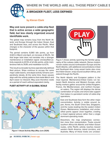
Figure 1 shows activity spanning the familiar geography of the subsea cable network. Dense clusters remain visible around northwestern Europe and the North Atlantic, with additional concentrations in East and Southeast Asia. Long vessel tracks also cross the Indian Ocean, wrap around southern Africa, and extend through the Pacific. The North Atlantic and European pattern is the most layered. Maintenance-linked tracks run between North America and Western Europe, while facility markers gather around the United Kingdom, France, the Mediterranean, and northern European waters. The region still displays the dense combination of routes and shore-side support that makes it a persistent center of cable-ship operations. East and Southeast Asia form the other major concentration. Activity is visible around Japan, Korea, the South China Sea, Singapore, and the routes leading into the eastern Indian Ocean. Maintenance, installation, and unclassified points appear close together, creating a mixed regional picture rather than a single dominant operating mode.
Figure 1: Vessel Activity Map (May-June 2026) 32
SUBTEL FORUM | Issue 149
Elsewhere, the map emphasizes connection more than concentration. Tracks around southern Africa link Atlantic and Indian Ocean routes, while Pacific activity reaches toward western North America, island corridors, and Australia. Many of these tracks are unclassi-