WHERE IN THE WORLD ARE ALL THOSE PESKY CABLE S A FLEET REGAINS DEFINITION by Kieran Clark At the start of 2026, the global cable-ship fleet appeared busy but analytically indistinct. Vessels continued to move through the world’s main cable basins, but many of their pauses occurred away from clear operational anchors. Maintenance corridors remained visible, and factory-linked activity still appeared in places, but the fleet’s overall behavior was harder to classify than it had been during the closing months of 2025. March and April present a clearer picture. The fleet remains widely distributed, but vessel behavior is more strongly tied to the infrastructure that normally defines cable work. Maintenance activity again forms the dominant rhythm of the fleet, while installation signals become more visible around factory-linked regions. Unclassified behavior remains present, but it no longer overwhelms the dataset. The result is a spring operating pattern that looks more structured than the one seen in January and February. Ships are still moving across the same global basins, but their pauses now align more often with depots, factories, and recognizable cable corridors. The fleet appears less transitional and more firmly connected to identifiable operational roles.
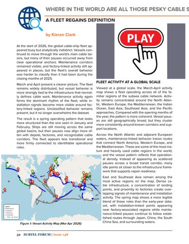
Figure 1: Vessel Activity Map (Mar-Apr 2026) 32
SUBTEL FORUM | Issue 148
FLEET ACTIVITY AT A GLOBAL SCALE Viewed at a global scale, the March-April activity map shows a fleet operating across all of the familiar regions of the subsea cable network. Activity remains concentrated around the North Atlantic, Western Europe, the Mediterranean, the Indian Ocean, East Asia, Southeast Asia, and the Pacific approaches. Compared with the opening months of the year, the pattern is more coherent. Vessel pauses are still geographically broad, but they cluster more consistently around known corridors and support locations. Across the North Atlantic and adjacent European waters, maintenance-linked behavior traces routes that connect North America, Western Europe, and the Mediterranean. These are some of the most mature and heavily used cable regions in the world, and the vessel pattern reflects that operational density. Instead of appearing as scattered pauses across a broad transit corridor, many idle points sit closer to the infrastructure framework that supports repair readiness. East and Southeast Asia remain among the most active regions on the map. Dense cable infrastructure, a concentration of landing points, and proximity to factories create overlapping signals of maintenance and installation activity. The spring map shows a more legible blend of those roles than the early-year dataset, with installation-linked points appearing near factory-associated regions while maintenance-linked pauses continue to follow established routes through Japan, China, the South China Sea, and surrounding waters.