V isions
ydro
HISSN 2837-5696
HYDROVISIONS is the official publication of the Groundwater Resources Association of California (GRA). GRA’s mailing address is 808 R Street. Suite 209, Sacramento, CA 95811. Any questions or comments concerning this publication should be directed to the newsletter editor at hydrovisions@grac.org
The Groundwater Resources Association of California is dedicated to resource management that protects and improves groundwater supply and quality through education and technical leadership.
EDITOR
Rodney Fricke hydrovisions@grac.org
EDITORIAL LAYOUT
Smith Moore & Associates
EXECUTIVE OFFICERS
PRESIDENT
Erik Cadaret
Yolo County Flood Control & Water Conservation District
VICE PRESIDENT
Abhishek Singh INTERA
SECRETARY
Clayton Sorensen
West Yost Associates
TREASURER
Marina Deligiannis
Sacramento Area Sewer District
DIVERSITY, EQUITY AND INCLUSION OFFICER
Annalisa Kihara
State Water Resources Control Board
IMMEDIATE PAST PRESIDENT
Christy Kennedy
Woodard & Curran
ADMINISTRATIVE DIRECTOR
Amanda Rae Smith
Groundwater Resources Association of California
To contact any GRA Officer or Director by email, go to www.grac.org/board-of-directors
DIRECTORS
Jena Acos
Brownstein Hyatt Farber Schreck
Christopher Baker CA DWR
Matthew Becker
California State University Long Beach
Trelawney Bullis
AC Foods, Central Valley
Dave Ceppos
Public Policy Mediation and Facilitaion
Elie Haddad
Haley & Aldrich
Dr. Hiroko Hort
GSI Environmental, Inc
Len Mason
Geosyntec Consultants, Inc.
Melissa Turner
MLJ Environmental
Savannah Tjaden
Environmental Science Associates
Roohi Toosi
APEX Environmental & Water Resources
R.T. Van Valer
Retired
The statements and opinions expressed in GRA’s HydroVisions and other publications are those of the authors and/or contributors, and are not necessarily those of the GRA, its Board of Directors, or its members. Further, GRA makes no claims, promises, or guarantees about the absolute accuracy, completeness, or adequacy of the contents of this publication and expressly disclaims liability for errors and omissions in the contents. No warranty of any kind, implied or expressed, or statutory, is given with respect to the contents of this publication or its references to other resources. Reference in this publication to any specific commercial products, processes, or services, or the use of any trade, firm, or corporation name is for the information and convenience of the public, and does not constitute endorsement, recommendation, or favoring by the GRA, its Board of Directors, or its members.
Page 36
President’s MessaGe
it’s suMMer!
Dear GRA Members and Groundwater Super Fans!
It’s summer! You know what that means! Flippy floppy’s, shorts & sun dresses, and Ray-Bans! My SoCal beach vibe roots will never go out of style *wink*. The past few months have been incredibly exciting for GRA with LOTS to share, so let’s get into it!
In case you haven’t heard, GRA now has a Mentorship Program being led by Director Roohi Toosi. GRA has tried and mostly failed to keep momentum on a GRA mentorship program in the past, but this time feels different. Director Toosi has pulled together an all-star list of dedicated mentors and recruited an engaged and bright cohort of mentees. This effort has resulted in 16 formal mentor-mentee pairs spanning private, public, and academia. The program is designed as a long-term career growth initiative, focused on professional judgment, leadership development, and relationship building rather than job placement, which traditionally has been the function of the SNAPP1 talks at the Western Groundwater Congress and branch meetings. A half a year into the start of the program and I personally am optimistic that this program has momentum, long-term value, and will recruit quality talent into the groundwater industry where demand to plan and implement projects has skyrocketed in recent years and is showing no signs of slowing down.
In June, we had the SGMA Summit in Clovis in the heart of where the realities of SGMA are being felt the most. I can confidently say that Director Trelawney Bullis, Sam Cunningham, and the entire planning team delivered in a big, impactful way that I was delighted to witness firsthand. The panelists didn’t play it safe and laid it all on the table. They dug in and got real about the ripple effects SGMA has had on communities in the valley. What struck me the most about the panelists was their ability to go deep, express what they were really thinking and feeling, even if it was hard for others to hear or understand, and yet still found a way to land on why, even though it’s hard and at times seems impossible, there’s a path forward through collaboration and belief in one another to find the right solutions and make them a reality. It truly was a beautiful thing to witness, and it prompted attendees to get engaged to a level I have not yet seen at a GRA conference. When I thought it couldn’t get any better, it did on day two when Aaron Fukuda from Mid Kaweah GSA led a full room of people through a game his staff developed that puts you into the shoes of a grower to make management decisions on the crop you grow, water availability, etc. The post-game comments and observations people shared blew me away and the main takeaway for me was a recognition of the difficult realities growers face that most of us were unaware what is occurring on a daily basis. Thank you Trelawney and Sam for an incredibly meaningful conference experience that had a significant impact on all of us!
During July, we had our annual virtual education offering Groundwater 101 Week. The webcasts provided great opportunities to learn more about geophysics, well design, aquifer testing, groundwater quality, PFAS, contaminant characterization and remediation, groundwater modeling, risk assessment, technical writing and presentation, and early career industry tips. These courses are a perfect fit for students or agency staff new to groundwater or would like to brush up on these topics to be more effective in their current roles. I have known several individuals outside of my organization who have taken courses in the past and shared with me how helpful they were. They walked away with actionable information to apply what they learned and felt more comfortable working on the project. Take a look and see what might be applicable to you!
Coming up in September, we have our flagship conference, the Western Groundwater Congress (WGC) that will take place in Palm Springs. Moises Santillan and his dedicated team of volunteers are putting together a fantastic conference program that I think will deliver a unique attendee experience this year that will make an impact. Groundwater professionals will be able to dive deep into the technical talks, engage with their peers in panel and workshops sessions, recruit new talent and meet students at the SNAPP talks, and participate in fun activities that bring the elevated music festival vibe. The team has put A LOT of thought and energy into planning this conference and it’s shaping up to be another one for the record books!
I’m energized by what GRA has delivered so far and has cooking in the near future. What about you? Are you feeling energized?! We would love to see you get involved in GRA. How can you contribute? Share your ideas and feedback—let’s co-create GRA’s future. Together, we’ll guide the groundwater community toward a more innovative, resilient era that delivers lasting value to our diverse communities!

Erik Cadaret President, Groundwater Resources Association
1. Student Networking and Participation Program
President’s MessaGe


Hydro Visions
ModelinG Pfas leacHinG to Groundwater for reGulatory coMPliance – Part 2:
nuMerical ModelinG of Pfas transPort in tHe Vadose Zone
by
John Stults, CDM Smith; Jenny Lagerquist, INTERA, Inc.; Raghavendra Suribhatla Maruti, Haley & Aldrich; Faran Torres, EA Engineering; Hiroko Hort, GSI Environmental
The previous HydroVisions article (Modeling PFAS Leaching to Groundwater for Regulatory Compliance-Part 1)1 discussed simplified empirical modeling, and the necessary parameters and measurement techniques for estimating PFAS impacts to underlying groundwater from the vadose zone soils. Within the parameter discussion, the Part 1 article also reviewed partitioning of PFAS (Equations 5 and 6 [air-water interfacial partitioning], and solid phase partitioning), which are critically important for numerical simulations of water and PFAS flux.
While simplified empirical models are useful for simple sites or preliminary remedial investigations, more complex modelling is often needed to appropriately assess risk and demonstrate compliance. This article summarizes the background of vadose zone numerical flow modeling and various model options available for direct, integrated simulation of flow and mass transport of PFAS.
Vadose zone transport models range from simplified screening models and analytical solutions, to numerical 1-D models, to full scale 2-D/3-D models. Higher complexity models typically require more comprehensive site characterization data to justify model development and validation costs. Generally, practitioners start with the most simplified models available and progress to more complex models, as needed.
Vadose Zone Modeling Background
The fundamental basis for water flux in the vadose zone was developed by Lorenzo A. Richards2 in 1931. Richards demonstrated that capillary pressure, gravitational potential energy, and head in porous media drive flow in unsaturated media. Richards also identified that hydraulic conductivity for unsaturated systems was distinctly different from saturated systems and scaled according to the capillary pressure of the system. Equations 7 and 8 present Richards Equation and the Richards Equation based calculation of Darcy Flux, respectively.
Eq. 7
Eq. 8
Where θ w volumetric water content, t is time, z is the longitudinal length of the vadose zone in the direction of gravity, is the capillary pressure in units of water head, q is the darcy flux in the direction of gravity, and K() is the unsaturated hydraulic conductivity as a function of capillary pressure.
isions
Relationships between capillary pressure, wetting/nonwetting phase fluid type, and wetting/non-wetting phase fluid were then pioneered by Buckley and Leverett3 working in the oil and gas industry in the 1940s. The capillary pressure of a system was recognized to be directly proportional to the wetting phase fluid saturation of the system. The saturated hydraulic conductivity could therefore be scaled using Buckley-Leverett type scaling functions to develop “water retention” functions to relate unsaturated hydraulic conductivity to capillary pressure. The first broadly accepted water retention function for the vadose zone was the Brooks and Corey4 model in 1964. Van Genuchten5 developed a closed form, continuous water retention function in 1980 and this form is broadly used today. The Van Genuchten scaling equations are presented in Equations 9 and 10.
Modeling Options for Simulating PFAS Transport in the Vadose Zone
Significant effort over the past several years has been dedicated to the development of tools for simulating PFAS fate and transport in the vadose zone. As of this publication, 5 alternatives are currently available for simulating PFAS transport:
• SEVIEW 8.0 – PFAS (Screening – cell based numerical) – SEVIEW graphical user interface (GUI) is a commercial product built using the SESOIL/ AT123D open-source code. The most recent version of SEVIEW (Version 8.0 - PFAS) includes an update that allows for the simulation of air-water interfacial partitioning of PFAS. SESOIL is a vadose zone screening-level model originally created for the EPA in 1981. AT123D is an analytical model of groundwater flow developed by G.T. Yeh8 in 1981 that is coupled to SESOIL. SESOIL is a 1-D model that can be discretized into multiple layers and simulates water/contaminant flux on a monthly basis using the Brooks and Corey Model.
Where θr is the residual water content, θ s is the saturated water content (or porosity), α is the empirical air-entry pressure term for the media, n is the empirical pore size distribution term for the media, m = n-1, and K s is the saturated hydraulic conductivity of the media.
Equations 7 through 10 are the fundamental basis for estimating water flux in most numerical models. The water flux terms are coupled to solute flux through the advection dispersion equation (ADE), which estimates solute velocity as the darcy flux (q) divided by the water content (θ w) and the Retardation factor (Rd).6 The retardation factor for the 1-D ADE is presented in Equation 5 of the Part 1 article. The α, n terms can be empirically measured using ASTM D6836 or estimated using soil textural properties (i.e. sand/silt/ clay ratios) in the ROSETTA7 software. The K s term can be measured using ASTM D5084 (Ks < 10-6 m/s) or ASTM D2434 (Ks > 10-7 m/s) or estimated using soil textural properties in the ROSETTA software.
• PFAS-LEACH-ANALYTICAL (Screening – Analytical Solution) – PFAS-LEACH-ANALYTICAL is part of the PFAS-LEACH toolbox that was developed by the University of Arizona in partnership with the SERDP/ ESTCP program and is currently available on GitHub9 for free. It uses a 1-D, steady state analytical solution to estimate the PFAS mass discharge rate through the vadose zone using the annual net recharge and the Van Genuchten equations. Solid phase partitioning and air-water interfacial partitioning are the primary mechanisms in the simulation. The modified EPA DAF model calculations are also built into the tool, as is a groundwater concentration estimation module. PFASLEACH-ANALYTICAL is advantageous because of its Excel format with options to pre-populate important parameters based on easily measured site conditions (i.e. soil type, net recharge, median grain diameter, foc).
article continues on next page
Eq. 9
Eq. 10
• PFAS-LEACH-COMP (Numerical 1-D/2-D/3-D) – As part of the PFAS-LEACH toolbox, PFAS-LEACHCOMP is a 1-D/2-D/3-D numerical modeling suite for simulating PFAS transport in the vadose zone. Rather than using simplifying assumptions (i.e. steady state), a fully numerical form of Richards Equation and the Van Genuchten Equations are used to simulate PFAS transport through the vadose zone to the underlying groundwater. Non-equilibrium transport can be simulated using the two-site model for both the solid phase and the air-water interface. The tool is written in Python and free but does not have an integrated GUI. The expected release date of PFAS-LEACH-COMP is Summer 2026.
• HYDRUS – (Numerical 1-D/2-D/3-D) – HYDRUS10 is a commercial product which can simulate water flux and contaminant transport in 1-D, 2-D or 3-D. HYDRUS has long been considered a gold standard for simulating water, heat, and solute flux through the vadose zone, including complex processes such as degradation and non-equilibrium. HYDRUS includes numerical inversion tools and multiple water-retention functions, and the 2-D/3-D versions can also simulate saturated-zone transport; 1-D outputs can be coupled to groundwater models as recharge or mass-loading inputs. Several add-on packages are available at additional cost, including PFAS-specific functionality for simulating air-water interfacial partitioning in the vadose zone. The cost of the commercial product scales with the complexity of the modeling options available.
• MODFLOW-USGT-PFAS (Numerical 1-D/2-D/3-D) – MODFLOW-USGT-PFAS was developed by Sorab Panday11MODFLOW-USG-Transport PFAS or “USGT-PFAS.” The USGT-PFAS model incorporates adsorption onto air-water interfaces, providing a more comprehensive understanding of PFAS retention near the water table and release to groundwater. Modeling of a hypothetical perfluorooctane sulfonic acid (PFOS at GSI. The tool builds on the MODFLOW-USGT tools by adding a module for the direct simulation of flow and solute transport in the vadose zone using the Richards equation. This model considers both the partitioning of PFAS to the solid phase and air-water interface and is similar to both PFAS-LEACH-COMP & HYDRUS in its scope and capabilities. This tool is advantageous because it builds on the backbone of a commonly used groundwater simulation tool (MODFLOW). The program is free to use with various free and licensed GUIs available.
Model Selection and Summary
As is the case with all models, there is no one-size-fits-all solution for site specific simulation of PFAS in the vadose zone. Models should be selected according to the relevant transport pathways identified in conceptual site models, project needs/scope, appropriate assumptions for the site, and ability of the model to accurately simulate site conditions. The capabilities of each model identified are summarized in Table 1.
Table 1: Key viability metrics for the five models discussed in this section.
References
(1) Stults, J. F.; Lagerquist, J.; Young, K.; Hort, H.; Fitzpatrick, H. Modelling PFAS Leaching to Groundwater for Regulatory Compliance - Part 1. HydroVisions. Groundwater Resources Association of California May 1, 2026, pp 16–19.
(2) Richards, L. A. Capillary Conduction of Liquids through Porous Mediums. Journal of Applied Physics 1931, 1 (5), 318–333. https://doi. org/10.1063/1.1745010.
(3) Leverett, M. C. Capillary Behavior in Porous Solids. Transactions of the AIME 1941, 142 (01), 152–169. https://doi.org/10.2118/941152-G.
(4) Brooks, R. H.; Corey, A. T. Hydrualic Properties of Porous Media. Colorado State University 1964
(5) Van Genuchten, M. Th. A Closed‐form Equation for Predicting the Hydraulic Conductivity of Unsaturated Soils. Soil Science Soc of Amer J 1980, 44 (5), 892–898. https://doi.org/10.2136/sssaj1980.03615995004400050002x.
(6) Genuchten, M. T. V.; Wierenga, P. J. Mass Transfer Studies in Sorbing Porous Media I. Analytical Solutions. Soil Science Society of America Journal 1976, 40 (4), 473–480. https://doi.org/10.2136/sssaj1976.03615995004000040011x.
(7) Schaap, M. G.; Leij, F. J.; Van Genuchten, M. Th. Rosetta : A Computer Program for Estimating Soil Hydraulic Parameters with Hierarchical Pedotransfer Functions. Journal of Hydrology 2001, 251 (3–4), 163–176. https://doi.org/10.1016/S00221694(01)00466-8.
(8) Yeh, G. T. AT123D: Analytical Transient One-, Two-, and Three-Dimensional Simulation of Waste Transport in the Aquifer System; ORNL-5602, 6531241; 1981; p ORNL-5602, 6531241. https:// doi.org/10.2172/6531241.
(9) Guo, B. PFAS-LEACH-Tier3-4. https://github. com/GuoSFPLab/PFAS-LEACH-Tier-3-4 (ac cessed 2025-12-19).
(10) Silva, J. A. K.; Šimůnek, J.; McCray, J. E. A Modi fied Hydrus Model for Simulating Pfas Transport in the Vadose Zone. (10). https://doi.org/10.3390/w12102758.
(11) Hort, H. M.; Stockwell, E. B.; Newell, C. J.; Scalia, J.; Panday, S. Modeling and Evaluation of Retention in the Unsaturated Zone above the Wa ter Table. Groundwater Monitoring Rem (3), 38–48. https://doi.org/10.1111/gwmr.12662.
ENVIRONMENTAL SEQUENCE STRATIGRAPHY
Groundwater Geology to Optimize Sustainable Groundwater Management
Environmental Sequence Stratigraphy (ESS) is a Geosyntec Best Practice for Groundwater Basin Characterization which is the foundation for all things related to sustainable groundwater management, including:
• Hydrogeological conceptual models
• Groundwater modeling
• Interconnected surface water-groundwater
• Subsidence analysis
• Managed Aquifer Recharge (MAR)
• Aquifer Storage and Recovery (ASR)
• Groundwater monitoring networks
West Coast Basin, LA County
ESS and PFAS
Because this approach creates a nuanced geological understanding of
to supporting remedial investigation programs involving per- and
approach is is a critical step in defining contaminant source and pathways groundwater monitoring programs.
Both the United States Air Force and Navy consider ESS to be a best because standard step-out “plume chasing” is not practical given the mobility, and stringent drinking water standards of these substances. ESS PFAS are likely connected to a source under investigation, or whether they
For more information, please contact our
Technical Truth: Geology is the primary control on groundwater flow
Because this approach creates a nuanced geological understanding of permeability and groundwater flow, it is uniquely suited to supporting remedial investigation programs involving per- and polyfluoroalkyl substances (PFAS). This geology-focused approach is is a critical step in defining contaminant source and pathways to effectively target sampling locations and groundwater monitoring programs.
Rick Cramer, PG rick.cramer@geosyntec.com
James Gonzales, PG, CHG james.gonzales@geosyntec.com
Both the United States Air Force and Navy consider ESS to be a best practice for PFAS investigations and remediation because standard step-out “plume chasing” is not practical given the ubiquitous occurrence, low detection limits, high mobility, and stringent drinking water standards of these substances. ESS also helps clients understand whether detected



WATER EXPERTS
Related Services
Groundwater and Surface
Water Modeling
Litigation Support
Managed Aquifer Recharge
Hydrogeologic Feasibility
Studies
Subsidence Risk Evaluations
Stormwater Management
CALIFORNIA LOCATIONS
PFAS Assessment & Remediation
Water Well Design & Construction
Sustainable Groundwater Management
Groundwater Quality Assessment & Mitigation
Hydro Visions
takinG tHe leaP for ManaGinG subsidence in tHe central Valley
by Nick Newcomb, Kait Palys, Jordon Navarrot, Pete Dennehy, and John Ellis
Addressing subsidence in the Central Valley will require a monumental and coordinated effort. This article summarizes regional and local subsidence management strategies being considered or implemented in some areas in the state with the highest subsidence rates. Over the first 10 years of SGMA, groundwater sustainability agencies (GSAs) have developed management plans that address local subsidence conditions utilizing DWR’s InSAR data, other local subsidence datasets, and groundwater level monitoring to better understand the physical processes causing subsidence. DWR released the final Best Management Practices (BMP) of the Sustainable Management of Groundwater: Land Subsidence in January 2026 to help clarify expectations for managing subsidence. The message is clear: the time has come for subsidence management plans to move off the page and into practice to protect critical infrastructure in the Central Valley by a) avoiding and minimizing subsidence and b) raising or stabilizing groundwater levels where needed.
Management Strategies
The most effective subsidence management strategies in the Central Valley focus on protecting critical infrastructure, minimizing inelastic compaction, and stabilizing and raising groundwater levels (as needed). Consistent with DWR’s Subsidence BMP, management actions are increasingly aimed at preventing groundwater levels from falling below critical heads and, where feasible, raising levels above them to slow both active and residual subsidence.
Because subsidence commonly extends across groundwater subbasin boundaries, regional coordination is essential. Efforts in the Tulare Lake Hydrologic Region (TLHR)—including the Tulare Lake, Tule, and Kaweah Subbasins—and coor-
dinated planning across the Yolo and Colusa Subbasins, highlighted in this article, reflect the need for shared monitoring, data evaluation, and management actions. At the local level, agencies are implementing targeted measures such as pumping allocations or moratoriums near critical infrastructure, aquifer-specific demand management, and managed aquifer recharge (MAR) programs using recharge basins, agricultural recharge, conjunctive use, and aquifer storage and recovery (ASR) wells. Together, these regional and local strategies represent the next step toward groundwater sustainability while helping limit subsidence impacts.
Westside Subbasin
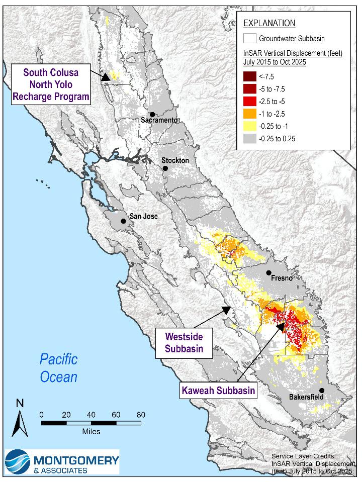
Land subsidence in the Westside Subbasin (Figure 1) has been a recognized concern for over a century. The construction of the San Luis Branch of the California Aqueduct (SLC) in the late 1960s provided surface water supply that reduced groundwater pumping, substantially slowing the high rate of subsidence. However, reductions in surface water deliveries in recent decades have increased the reliance on groundwater pumping in some dry years, creating water supply conditions for potential further subsidence. Freeboard has been reduced in portions of the SLC due to historical subsidence, which may limit downstream deliveries to State and Federal water contractors. As the Subbasin’s GSA, Westlands Water District has responded proactively with projects and management actions (PMAs) focused on water supply enhancement and demand reduction. This work includes coordination with the California Aqueduct Subsidence Program, State Water Project operators, and other agencies to support groundwater sustainability and protect aqueduct conveyance capacity.
Supply enhancement strategies are intended to increase groundwater storage using MAR to enhance aquifer resiliency. This approach has been implemented through
isions
GSA-owned recharge ponds and ASR facilities coupled with financial incentives, studies, and environmental approval for landowners to implement similar projects. The GSA and its water users dedicated over 470,000 acre-feet (AF) of water to recharge projects during the 2023 historically wet and 2024 above normal water years, which directly increased groundwater levels, groundwater in storage, and contributed to elastic rebound of the land surface in large areas of the GSA.
Demand reduction strategies have centered around groundwater pumping management and changes to land use policy. The GSA’s Groundwater Allocation Program, which began implementation in 2020, includes a 10-year phased implementation schedule, mandatory well registration, and real-time metering of all non-de minimis groundwater extractions to align groundwater extraction with the Subbasin’s sustainable yield. The Targeted Pumping Reduction Program enables the GSA to incentivize landowners to reduce groundwater pumping near hydraulically impaired portions of the SLC depending on water level and subsidence conditions.
Land repurposing is also being used to reduce groundwater demand in areas with subsidence risk. Through direct land acquisition, 5,349 irrigable acres near the SLC have been retired, with additional large-scale agricultural land repurposing pursued through the Valley Clean Infrastructure Plan and the Multi-Benefit Land Repurposing Program. Subsidence management in the Westside Subbasin remains an active, ongoing effort. Westlands Water District continues to invest substantial resources for sustainable groundwater management and adapt its strategy in the most at-risk areas, illustrating how targeted implementation can support groundwater sustainability while protecting critical infrastructure.
Kaweah Subbasin
The Kaweah Subbasin (Figure 1) illustrates how SGMA implementation can become especially complex in areas where subsidence, overdraft, and competing groundwater demands must all be managed at once. The Subbasin is managed through close coordination by three GSAs—East
Kaweah, Greater Kaweah, and Mid-Kaweah. Although the Subbasin has relatively limited exposure to the major canalconveyance risks seen elsewhere in the State, preventing flooding caused by differential subsidence remains a concern, particularly after the historically wet 2023 water year. The Kaweah Subbasin’s subsidence management approach relies on targeted demand management, MAR, and regional coordination to reduce overdraft and limit subsidence.
East Kaweah and Mid-Kaweah GSAs have implemented strict allocations that effectively eliminate overdraft, aligning allowable pumping with native and sustainable yield since 2022, while Greater Kaweah GSA has scheduled ramp-down reductions of groundwater overdraft. The GSAs are considering aquifer-specific monitoring, management actions, and policies to better manage lower-aquifer pumping where it presents the greatest subsidence risk.
While conceptually appealing, a by-aquifer allocation framework is difficult to implement in practice. Key constraints include significant data gaps in active well location and depths, construction, and perforation information, the widespread use of composite wells across multiple aquifers, and the coarse spatial resolution of available datasets used to delineate the Corcoran Clay and other compressible clay units. Adding further complexity, municipal reliance on lower-aquifer pumping can create localized subsidence that is not readily addressed through traditional agricultural allocation frameworks, and restrictions on deeper pumping may inadvertently shift demand to upper aquifers, increasing risks to shallow domestic wells. To manage these competing challenges, the GSAs are prioritizing improved well data collection through registration programs and a comprehensive well inventory exercise, as well as instituting policies such as Mid-Kaweah’s requirement linking registration to access to future groundwater allocations above the native yield.
The GSAs are using both MAR and demand management to increase groundwater supplies and reduce overdraft in areas affected by subsidence. To date, most recharge projects have relied on surface recharge basins. However, these projects often provide limited direct benefit to the lower aquifer beneath the Corcoran Clay, where subsidence is generally understood
article continues on next
to occur. Even so, increasing groundwater availability in the upper aquifer above the Corcoran Clay can support aquifer-specific allocation policies designed to reduce pumping from the lower aquifer. A potential consequence of these policies is increased demand on the upper aquifer where conditions allow, underscoring the need to evaluate and manage impacts on vulnerable beneficial users such as domestic well owners who depend on stable upper-aquifer groundwater levels. In addition, the GSAs are prioritizing the development of more targeted strategies to benefit the lower aquifer, including expanding conjunctive use programs that maximize surface water deliveries in lieu of groundwater pumping in the most affected areas, evaluating direct lower-aquifer recharge through ASR or injection wells, and implementing other demand management measures, such as potential fallowing of land currently in production.
The Subbasin continues to work through these interconnected challenges, recognizing they are not unique to the Kaweah Subbasin. Through the 2024 GSP Amendment, the Subbasin kicked off a formal multi-subbasin effort focused on coordination and idea-sharing among the TLHR subbasins facing similar subsidence issues. This effort, internally referred to as the Regional Subsidence Management Action Plan (RSMAP), provides a forum to exchange approaches, lessons learned, and potential strategies for addressing shared technical and implementation hurdles.
Yolo and Colusa Subbasins
The South Colusa North Yolo (SCNY) Recharge Program is a voluntary, multi-agency collaboration formed to address longterm groundwater sustainability challenges, including subsidence across the Colusa and Yolo Subbasins (Figure 1). SCNY brings together irrigation districts, water agencies, private landowners, and other stakeholders to collectively fund and implement groundwater recharge projects to offset historical overdraft of approximately 15,000 acre-feet per year (AFY). The program works by pooling financial contributions from participating entities, leveraging state and federal grants, and directing funds to recharge infrastructure and projects. Local participation has grown rapidly, with over 82,000 acres enrolled, 66 entities involved, and more than $695,000 collected to support implementation efforts as of WY 2025.
In its first season in WY 2025, pilot recharge implementation with multiple methods—including trickle flow in ephemeral streams, recharge basins, and reverse tile drains — resulted in approximately 2,045 AF of recharge. Looking ahead, available resources and strong local participation suggest the program is well positioned to achieve its 15,000 AFY target for balancing historical overdraft and helping prevent future subsidence.
Overall, SCNY represents a proactive, locally driven approach to groundwater management, demonstrating that coordinated regional action can produce measurable results while maintaining agricultural productivity. The SCNY effort also shows the value of addressing subsidence early in the Sacramento Valley—before impacts become more severe— and may offer a useful blueprint for other areas facing similar conditions.
Conclusions
There is no one-size-fits-all approach to managing subsidence in the Central Valley. Success will depend on a combination of regional coordination and local management tailored to the hydrogeologic setting, infrastructure risks, and institutional realities of each subbasin. After a decade of data collection and planning, the focus must now shift to implementation. The case studies presented here illustrate three distinct approaches for addressing groundwater overdraft and reducing subsidence risks to the water supply and flood-control infrastructure within the Central Valley. The path forward is clear: if groundwater sustainability is the destination, effective subsidence management is the leap the Central Valley must take to get there.
References
DWR, 2026. Best Management Practices of the Sustainable Management of Groundwater: Land Subsidence. https://water.ca.gov/-/media/DWR-Website/Web-Pages/ Programs/Groundwater-Management/SustainableGroundwater-Management/Best-Management-Practices-andGuidance-Documents/Files/Land_Subsidence_BMP.pdf
Figure 1: Case Study Locations and Subsidence Measured by InSAR 2015–2025

Hydro Visions
aquifers on tHe rocks: iMPortance and cHallenGes of fractured rock aquifers
by Jim Blanke, Trey Driscoll, Chad Taylor, Gus Tolley, and Marcus Trotta
Introduction
The first article of this series, Flowing Through the Cracks: Non-Basin Groundwater in California, introduced the importance of non-basin groundwater, particularly in the state’s mountainous and foothill regions. Fractured rock aquifers underlie approximately 60 percent of California’s land area and support diverse beneficial uses ranging from domestic water supply to ecosystem maintenance. This article examines the technical challenges of assessing fractured rock aquifers, including how conventional groundwater assessment methods fall short, how well performance varies across similar geological settings, and implications for water resource management under increasing demand and
climate uncertainty. This article sets the stage for the third and final article, Liquid Labyrinths: Regulatory Challenges for California’s Fractured Rock Wells, which will examine regulatory and management approaches for this critical resource.
A Hidden Lifeline for Rural California
Fractured rock aquifers serve as the primary water source for many of the 7.2 million Californians living in non-basin areas (DWR, 2026a), predominantly in rural and foothill communities where connection to public water systems is not economically feasible. Unlike their alluvial counterparts, whose understanding benefits from over a century of development, optimization, and study, fractured rock systems remain relatively poorly understood despite their critical importance.
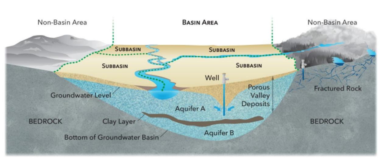
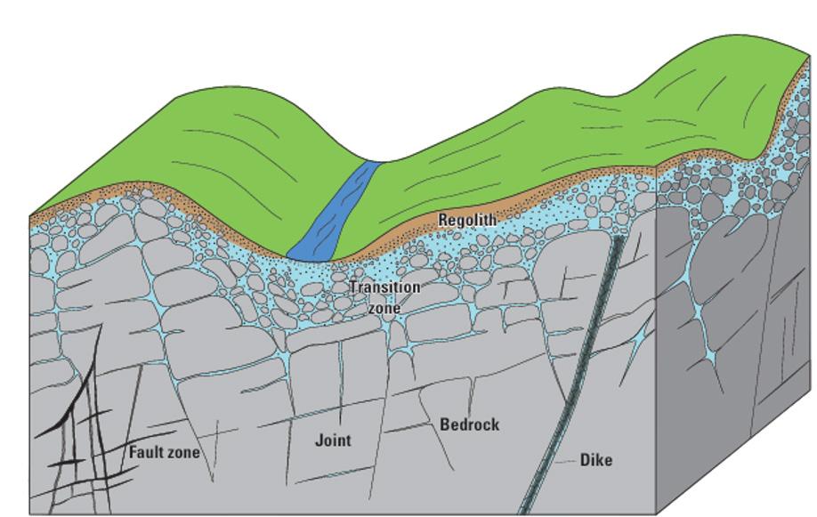
Conceptual cross section showing fractured rock aquifers underlying foothill areas upgradient from alluvial aquifers (DWR, 2026a).
isions
These aquifers commonly perform three essential functions. First, they provide direct water supply through domestic, community, and agricultural wells. Second, they act as forebay recharge sources for downgradient alluvial aquifers, with infiltration through fractured rock ultimately sustaining more productive basin aquifers. Third, they support baseflow to streams and groundwater-dependent ecosystems, particularly during drought.
However, fractured rock aquifers possess inherent vulnerabilities. Their limited storage capacity can produce rapid water level fluctuations in response to changes in recharge or extraction, which may limit the duration over which they can sustain baseflow and buffer drought impacts. Additionally, fractured rock aquifers often facilitate more rapid contaminant migration compared to alluvial aquifers due to preferential flow through fractures and lower rates of adsorption and other retardation processes. Fracture connectivity is difficult to predict, and minor changes in pumping can produce unexpectedly large impacts on neighboring wells or ecological resources.
Well Performance: Expectations and Realities
One of the most striking characteristics of fractured rock aquifers is the dramatic variability in well yields, even over short distances. A USGS study in southwestern Nevada County documented yields ranging from 2 to 300 gallons per minute (gpm), with a median around 10 gpm. The study further showed no significant relationship between yield and various hydrogeologic or topographic characteristics (Page et al., 1984). This variability reflects the fundamental nature of fractured rock systems, where groundwater occurrence is controlled by the presence, orientation, aperture, and connectivity of fractures.
For property owners and developers, this variability creates significant financial uncertainty. While conventional wisdom might suggest that drilling deeper increases the likelihood of encountering productive fractures, field experience often contradicts this assumption. In some geological settings, fracture density and aperture decrease with depth as overburden stress closes fractures. In others, major waterbearing fractures may exist at considerable depth, particularly where associated with regional fault or shear zones (Page et al., 1984; Kaehler and Hsieh, 1994; Landon et al., 2015).
Well performance can also vary seasonally and in response to drought conditions. During extended dry periods, water levels in fractured rock systems may decline rapidly due to limited storage, reducing well yields or causing shallow wells to go dry. Water quality may change as well; some wells in areas with surface water irrigation or high septic density may experience increased nitrate and coliform concentrations during drought as recharge sources shift (Levy et al., 2020). Recovery following drought can be equally unpredictable, depending on fracture network characteristics and recharge patterns.
Conceptual cross section of a fractured-bedrock aquifer (USGS 2022).
Assessment Challenges and Technical Limitations
Traditional groundwater assessment methods, developed primarily for alluvial aquifers, are often poorly suited to fractured rock systems. The fundamental challenge lies in scale-dependent heterogeneity: the factors controlling bedrock groundwater occurrence and flow operate at multiple scales, from individual fractures (fractions of inches to feet) to regional fracture networks (miles). This complexity makes it difficult to extrapolate findings from one location to another, even within the same geological formation.
Monitoring network design presents particular challenges. The sparse distribution of domestic wells in rural areas limits data availability, while the high cost of drilling and instrumenting monitoring wells restricts the density of observation points. Unlike alluvial basins where aquifer properties can be reasonably interpolated between wells, fractured rock aquifers may exhibit significant property changes over tens or hundreds of feet due to variations in fracture characteristics.
Field investigation techniques adapted from engineering geology and petroleum geology offer some solutions. Fracture trace analysis, which involves identifying linear surface features that may reflect underlying fracture zones, can help predict potentially productive drilling locations (Yin and Brook, 1992). Photo-lineament mapping using aerial photography or satellite imagery extends this approach to larger areas. Borehole geophysical logging, particularly optical and acoustic televiewer logs, can characterize fracture orientation, aperture, and spacing, while flowmeter logging can identify which fractures contribute to well yield (Williams and Johnson, 2000). Unfortunately, advanced logging tools are often not used as they require specialized expertise and equipment, which increases costs and decreases availability. Most domestic bedrock well drilling proceeds without the benefit of detailed site characterization, relying instead on driller experience, local knowledge, and crossed fingers.
Regional
Examples: Diverse Settings, Common Challenges
The Sierra Nevada foothills exemplify many of the challenges associated with fractured rock groundwater development. This region features predominantly granitic and metamorphic rocks with locally intense fracturing. Residential development has accelerated in recent decades, putting stress on groundwater resources.
The California Department of Water Resources’ Dry Well Reporting System shows a band of wells in the Sierra Nevada foothills that have gone dry at some point (DWR, 2026b). This area is not subject to the Sustainable Groundwater Management Act (SGMA) and water supply is instead managed via a patchwork of local county agencies, if at all. From a water quality perspective, concerns are primarily due to naturally occurring inorganic constituents such as uranium, arsenic, boron, fluoride, and molybdenum that are derived from natural water–rock interactions (Fram and Belitz, 2014).
In Sonoma and Napa counties, where alluvial basins regulated under SGMA are largely bounded both laterally and vertically by the highly heterogeneous Sonoma Volcanics, groundwater managers face different but equally challenging conditions. The Sonoma Volcanics are a thick, highly variable, and locally deformed sequence of volcanic rocks interbedded with volcaniclastic sedimentary deposits, with wells exhibiting a large range of production yields from less than 10 gpm to several hundred gpm. Groundwater use from agricultural, rural residential, and municipal wells constructed within the Sonoma Volcanics along the margins of the alluvial basins locally represents a significant amount of water demand. The formation of Groundwater Sustainability Agencies (GSAs) in adjacent alluvial basins has raised questions about how to address fractured rock areas that are hydraulically connected to regulated basins but excluded from SGMA requirements (Sonoma Valley Groundwater Sustainability Agency, 2022). These conditions illustrate a recurring challenge under SGMA: fractured rock systems that are hydraulically connected to regulated alluvial basins but remain outside the formal management framework.
Southern California’s fractured rock aquifers, particularly those in the Peninsular Ranges batholith, demonstrate how structural geology influences groundwater occurrence. Fault zones and associated fracture networks often control high-yield well locations, with productivity strongly dependent on proximity to these features. Studies in the Lee Valley area documented hydraulic conductivity estimates spanning several orders of magnitude within the fractured crystalline rock aquifer, demonstrating the strong hydraulic heterogeneity characteristic of fracturecontrolled groundwater systems (Kaehler and Hsieh, 1994).
Looking Ahead
Fractured rock aquifers present distinct technical challenges that differentiate them from the alluvial basin aquifers that have historically received most management attention in California. The inherent heterogeneity of fractured systems, combined with limited data availability and complex assessment requirements, makes it difficult to apply conventional groundwater management approaches. Yet these aquifers are essential to millions of Californians and will become increasingly important as climate change alters precipitation patterns and population growth continues in foothill and mountain areas.
The third article in this series will examine the regulatory and policy challenges surrounding fractured rock groundwater management. How should California’s groundwater management framework address aquifer systems that are excluded from SGMA but hydraulically connected to regulated basins? What role should well permitting agencies, GSAs, and state agencies play? And how can management approaches balance the right of a property owner to the reasonable use of the underlying groundwater and the need to prevent undesirable impacts on neighboring users and environmental resources? Addressing these questions is essential to ensuring the long-term sustainability of groundwater resources throughout California.
References
California Department of Water Resources (DWR), 2026a, California’s groundwater: Bulletin 118, Update 2025.
California Department of Water Resources (DWR), 2026b, California’s Groundwater Live: Reported Dry Wells [web-based dashboard].
Fram, M.S., and Belitz, K., 2014. Groundwater Quality in the Sierra Nevada, California. U.S. Geological Survey Fact Sheet 20143096.
Kaehler, C.A., and Hsieh, P.A., 1994, Hydraulic properties of a fractured-rock aquifer, Lee Valley, San Diego County, California: U.S. Geological Survey Water-Supply Paper 2394.
Landon, M.K., Morita, A.Y., Nawikas, J.M., Christensen, A.H., Faunt, C.C., and Langenheim, V.E., 2015, Aquifer geometry, lithology, and water levels in the Anza–Terwilliger area—2013, Riverside and San Diego Counties, California: U.S. Geological Survey Scientific Investigations Report 2015–5131, Levy, Z.F., Fram, M.S., and Taylor, K.A., 2020, Effects of surface-water use on domestic groundwater availability and quality during drought in the Sierra Nevada foothills, California: U.S. Geological Survey Fact Sheet 2019–3077.
Page, R.W., Anttila, P.W., Johnson, K.L., and Pierce, M.J., 1984, Ground-water conditions and well yields in fractured rocks, southwestern Nevada County, California: U.S. Geological Survey Water-Resources Investigations Report 83-4262.
Sonoma Valley Groundwater Sustainability Agency (SVGSA). 2022. Groundwater Sustainability Plan for the Sonoma Valley Groundwater Subbasin.
U.S. Geological Survey, 2022, Assessment of well yield, dominant fractures, and groundwater recharge in fractured-bedrock aquifers, Wake County, North Carolina: U.S. Geological Survey Scientific Investigations Report 2022–5041.
Williams, J.H., and Johnson, C.D., 2000, Boreholewall imaging with acoustic and optical televiewers for fractured-bedrock aquifer investigations, in Seventh International Symposium on Borehole Geophysics for Minerals, Geotechnical, and Groundwater Applications, October 24–26, 2000, Proceedings: Minerals and Geotechnical Logging Society, Houston, p. 43–53.
Yin, Z.M., and Brook, G.A., 1992, The topographic approach to locating high-yield wells in crystalline rocks—does it work?: Ground Water, v. 30, no. 1, p. 96–102.

Modeling Software Development
Hydrogeological Modeling
Geochemical Investigation & Modeling
Contaminant Fate & Transport
Water Supply Evaluations
Aquifer Storage & Recovery
Managed Aquifer Recharge
Monitoring Well and Pump Performance Optimization
Remediation Engineering for Soil, Groundwater, and Surface Water
Sampling and Field Services
Expert Testimony & Litigation Support

Hydro Visions
seawater intrusion in california coastal aquifers
by Raghavendra Suribhatla Maruti, PhD, PE, Kyle Young, PhD, Patrick Wickham P.G., C.Hg, Rick Cramer, PG, Hannah Fitzpatrick, GIT, and Hanni Blair
In coastal aquifers, fresh groundwater naturally flows toward the ocean. This flow occurs because groundwater levels inland typically sit above sea level, creating a hydraulic gradient from land to sea. Fresh groundwater is less dense than seawater, so it tends to overlie saline groundwater near the coast. The transition between the two is commonly described as the freshwater-saltwater interface.
Seawater intrusion occurs when this natural condition reverses or weakens. Groundwater pumping can lower freshwater heads, reduce seaward groundwater flow, and allow saltwater to migrate landward or upward into aquifer zones used for water supply. This process can affect wells before the main freshwater-saltwater interface reaches them because mixing, dispersion, tidal effects, seasonal pumping, and aquifer heterogeneity can create a broad transition zone ahead of the interface.
Seawater is a potent source of groundwater degradation. A relatively small amount of seawater (1.5%) mixed into fresh groundwater can raise total dissolved solids and chloride concentrations above drinking water, agricultural, or operational thresholds. Chloride concentrations above 250 milligrams per liter exceed the U.S. Environmental Protection Agency secondary maximum contaminant level and can make groundwater unsuitable for some municipal and agricultural uses. Once saline water enters an aquifer, cleanup can take decades or longer because natural flushing is slow and aquifer materials may sequester and release saline water over time.
California’s Sustainable Groundwater Management Act identifies seawater intrusion as one of six undesirable results that Groundwater Sustainability Agencies (GSA) must evaluate and prevent. For coastal basins, GSAs must understand where and why intrusion has occurred historically, where and how it may occur in the future, and
what groundwater elevations or equivalent freshwater heads are needed to reduce potential for seawater intrusion.
Why Seawater Intrusion Occurs
Seawater intrusion typically results from the interaction between hydraulic potential and subsurface pathways. Groundwater overdraft creates hydraulic potential by lowering freshwater heads and reducing seaward gradients, while geologic conditions control the pathways and rates of saline water migration. Groundwater overdraft is the primary anthropogenic driver. When pumping exceeds the amount of water replenished by recharge, streamflow, imported water, recycled water, or other sources, groundwater levels decline. In coastal aquifers, these declines can reduce or reverse the hydraulic gradient that normally pushes fresh groundwater toward the ocean. During droughts, the risk often increases because surface water supplies decrease and groundwater pumping increases.
Geology and the related permeability architecture or the subsurface “plumbing” is the primary control on the occurrence, migration pathways, and inland extent of seawater intrusion. California’s coastal groundwater basins are heterogeneous aquifer systems rather than laterally continuous, homogeneous sand aquifers. They are formed by a variety of depositional systems that result in sedimentary facies (e.g., beach, estuarine, coastal dune, lagoonal, riverine, delta, and others) composed of variable amounts of gravel, sand, silt, and clay. Although complex and heterogeneous, each facies has characteristic depositional geometry, extent, and continuity. These materials create a hydrostratigraphic framework that controls groundwater movement. Coarsegrained, high-permeability units can serve as preferential pathways for seawater intrusion, while fine-grained, lowpermeability units can restrict vertical or lateral movement. As a result, seawater intrusion may advance inland along one aquifer zone while another nearby aquifer remains less affected.
isions

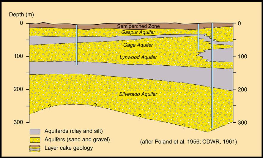
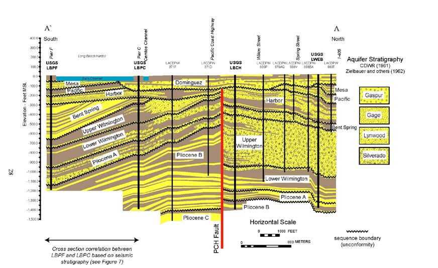
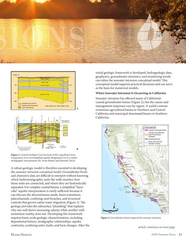
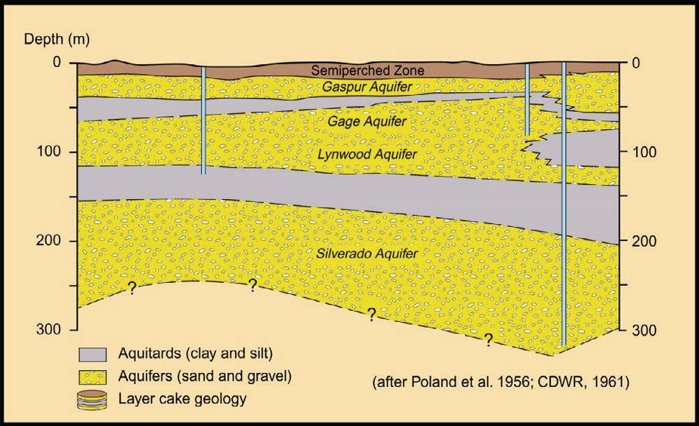
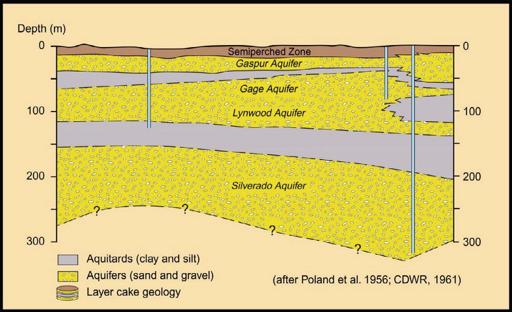
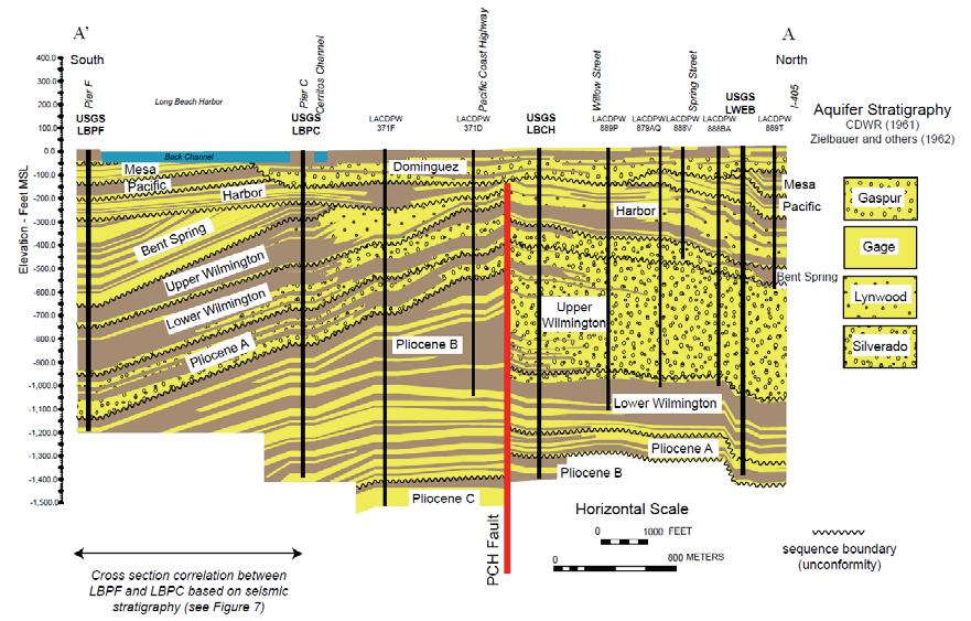
A robust geologic model is therefore essential to developing the seawater intrusion conceptual model. Groundwater levels and chemistry data are difficult to interpret without knowing which hydrostratigraphic units the wells monitor, how those units are connected, and where they are hydraulically separated. For complex coastal basins, a simplified “layercake” aquifer interpretation is rarely sufficient because it can obscure the discontinuous sands, facies transitions, paleochannels, confining-unit breaches, and structural controls that govern saline water migration (Figure 1). The geology provides the subsurface “plumbing” that explains why one well shows increasing salinity while another well, sometimes nearby, does not. Developing this framework requires basin-scale geologic characterization, including depositional history, stratigraphic relationships, aquifer continuity, confining units, faults, and facie changes. After the
initial geologic framework is developed, hydrogeologic data, geophysics, groundwater chemistry, and monitoring trends can refine the seawater intrusion conceptual model. This conceptual model supports practical decisions and can serve as the basis for numerical models.
Where Seawater Intrusion Is Occurring in California
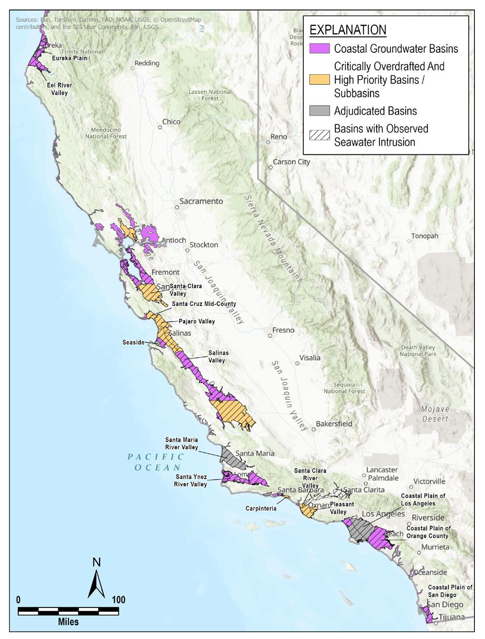
Seawater intrusion has affected many of California’s coastal groundwater basins (Figure 2), but the causes and management responses vary by region. A useful contrast is between agricultural basins in Northern and Central California and municipal-dominated basins in Southern California.
article continues on next page
Figure 1: Coastal Geologic Cross Sections in the Long Beach Area: Comparison of an oversimplified aquifer designation (A) to a robust stratigraphic interpretation (B). From Ehman and Edwards (2014)
Figure 2: Groundwater basins impacted by seawater intrusion
Along the Central Coast and parts of Northern California, groundwater demand is often tied to agriculture. Basins near the Monterey Bay, including the Pajaro Valley, Salinas Valley, and Seaside areas, have documented seawater intrusion concerns. These basins support high-value agriculture, including berries, vegetables, vineyards, and other crops. Pumping patterns can vary seasonally with irrigation demand and water availability strongly influencing groundwater use, especially during droughts.
In Southern California, seawater intrusion has occurred historically in heavily urbanized coastal basins, including portions of Los Angeles County and Orange County. These basins support large municipal and industrial water demands. Although cities often receive imported surface water, groundwater remains a critical part of the supply portfolio, especially during droughts or imported water shortages. Municipal groundwater demand differs from agricultural demand and is often more consistent throughout the year. However, drought, population growth, conservation, and imported water availability can change pumping patterns. Southern California has also developed some of the state’s most engineered seawater intrusion control systems and include freshwater injection barriers, recycled water recharge, spreading grounds, brackish groundwater extraction, and coordinated basin management. In Orange County, for example, purified recycled water has become a major component of groundwater replenishment and seawater intrusion control.
Equivalent Freshwater Head Versus Measured Water Levels
Evaluating seawater intrusion requires more than simply measuring groundwater levels. In coastal aquifers, groundwater density varies with salinity. A water level measured in a well containing brackish or saline water does not represent the same hydraulic potential as the same water level measured in a freshwater well; because saline water is denser, it exerts more pressure for a given water column height. The equivalent freshwater head, , corrects measured water levels for density differences so hydraulic gradients can be compared consistently across common elevations, Z:
(1), [ft MSL]
where:
hf = equivalent freshwater head, [ft MSL]
h = observed head, [ft MSL]
pf = fresh groundwater density, [≈1000 kg/m3 at 0 ppt salinity]
p = observed groundwater density, [kg/m3]
Z = elevation (e.g. of well screen) of groundwater observation, [ft MSL]
This correction is important where wells contain saline or brackish water, where vertical salinity gradients occur, or where monitoring networks include wells screened across different aquifer zones. Without this correction, water-level maps may misrepresent the direction and magnitude of groundwater flow.
For seawater intrusion analysis, equivalent freshwater head helps answer a key management question: Is enough freshwater pressure present to prevent landward or upward migration of saline water? Observed water levels require interpretation in the context of salinity, well construction, aquifer confinement, and vertical gradients to determine their protection against, and risk of, SWI.
Equivalent freshwater head is also important for setting protective thresholds. Many groundwater sustainability plans use groundwater elevations for minimum thresholds and for measurable objectives. In coastal basins, those criteria should consider density effects and the elevation needed to maintain a seaward gradient or protective freshwater head in the aquifer zones most vulnerable to intrusion. This requirement is especially important for multi-aquifer systems where shallow, intermediate, and deep zones may respond differently to pumping and recharge.
Building a Framework for SWI Management
Seawater intrusion is a long-term water supply risk for California’s coastal groundwater basins. Effective management starts with a seawater intrusion conceptual model that connects the basin’s geologic framework with the hydraulic and geochemical conditions that indicate intrusion risk. The model should identify vulnerable aquifer zones, evaluate groundwater levels and equivalent freshwater heads, track salinity trends, and relate observed changes to pumping, recharge, drought, and sea-level rise. Future articles in this series will build on this foundation by discussing analytical and numerical modeling tools, sea-level rise and groundwater-rise datasets, and guidance for evaluating coastal vulnerability.
References
California Department of Water Resources. 2017. Best Management Practices and Guidance Documents. https:// water.ca.gov/Programs/Groundwater-Management/SGMAGroundwater-Management/Best-Management-Practices-andGuidance-Documents
Ehman, K. D., and Edwards, B. D., 2014. Sequence
Stratigraphic Framework of Upper Pliocene to Holocene Sediments of the Los Angeles Basin, California: Implications for Aquifer Architecture, Pacific Section SEPM (Society for Sedimentary Geology), Book 112, Studies on Pacific Region Stratigraphy Fetter, C.W. (2001). Applied Hydrogeology (4th ed.). PrenticeHall, Inc.: Upper Saddle River, NJ, USA, 2001.
Jiao, J., and Post, V. 2019. Coastal Hydrogeology. Cambridge University Press.
Post, Vincent & Kooi, Henk & Simmons, Craig. (2007). Using Hydraulic Head Measurements in VariableDensity Ground Water Flow Analyses. Ground water. 45. 664-71. 10.1111/j.1745-6584.2007.00339.x.
U.S. Environmental Protection Agency. 2024. Secondary Drinking Water Standards: Guidance for Nuisance Chemicals. https://www.epa.gov/sdwa/ secondary-drinking-water-standards-guidancenuisance-chemicals
Werner, A.D., Bakker, M., Post, V.E.A., Vandenbohede, A., Lu, C., Ataie-Ashtiani, B., and Barry, D.A. 2013. Seawater intrusion processes, investigation, and management: Recent advances and future challenges. Advances in Water Resources, 51, 3-26.
Young, K. S. R., & Pradhanang, S. M. (2021). Small unmanned aircraft (sUAS)-deployed thermal infrared (TIR) imaging for environmental surveys with implications in submarine groundwater discharge (SGD): Methods, Challenges, and Novel Opportunities. Remote Sensing, 13(7), 1331. doi:10.3390/rs13071331
Hydro Visions
tHe Pace of trust
by DEI Committee Members: Angie Rodriguez-Arriaga, West Yost
Associates; and Hannah Fitzpatrick, GSI Environmental In groundwater work, and really across most fields, project timelines and scopes rarely account for how engagement actually unfolds. Engagement runs on continuity, reciprocity, and time, yet projects often run on fixed schedules set by regulatory triggers and fiscal years. The challenge for water professionals is to build and sustain relationships with communities even when those timelines pull in opposite directions.
That message was central to the training session by the Watershed Solutions Network (WSN) on Water History and Tribal Engagement and Relationship Building that GRA leadership attended in Davis during November 2025, facilitated. This article shares examples of engagement we thought would be helpful for water professionals embarking on their own engagement journey.
Start Before You Think You Need To
The catalyst for engagement may be a regulatory requirement, like SGMA coordination, or CEQA consultation. When engagement is framed as a task rather than a relationship, communities can end up responding to predefined scopes and timelines instead of helping shape them. The training helped us understand that engagement should be integrated in all aspects of project planning, in early project scoping, budgeting, and team assignments, in order for it to be meaningful.
Years, Not Months
Work in the South Fork Tule River watershed shows what engagement looks like over time. At CSU Long Beach, Dr. Benjamin Hagedorn studies the hydrologic and carbon cycles behind groundwater quality, recharge, and availability. One of their study areas is the South Fork Tule River watershed, a roughly 1,000-square-kilometer area in the southern Sierra Nevada of Tulare County that drains westward toward the
Tule Subbasin on the San Joaquin Valley. The Tule River Indian Reservation is located in the watershed and relies on groundwater and on the South Fork Tule River for surface water.
The relationship did not start with outreach, but rather a shared place. An earlier USGS project instrumented the watershed with stream gauges, including one at the Reservation boundary, which gave the team an initial presence in the location. Outreach to the Reservation came after that and those conversations led to an introduction to the Reservation’s hydrogeologist, who helped shape further collaboration. Graduate student Edgar Villasano carried that work forward, with master’s research on hydrograph separation and baseflow dynamics.
This relationship took years to develop, a key point being that the team had a shared investment in understanding the environment. Throughout their relationship, the Tribe’s authority over its own data stayed central rather than being a resource for outside research.
In Practice at the Committee
A natural opportunity for deeper connection with water communities has occurred at several GRA events, including opening statements by Tribal representatives at WGCs; and the importance of oral history at an AI symposium. For the 2026 Western Groundwater Congress (WGC), we started as soon as the location was set, a year out. We began by learning whose ancestral land the venue sits on, using Native Land, a resource shared by WSN at the training, and a great starting point to learn more about Indigenous territories, languages, lands, and ways of life predating modern colonial borders. We looked within the WGC planning community for anyone who already has a connection. Ahead of the 2026 WGC, a fellow GRA member shared an introduction that led us to a neighboring Tribe who has generously shared their time and knowledge with us.
isions
From there, we have tried to show up and listen to determine if the Tribe wanted to participate, rather than defaulting to a specific role. What came out of it has felt like a genuine deepening of our relationship with the broader water community.
A few things have made a difference for us when setting out to develop relationships: Being proactive and intentional about building a relationship means engagement isn’t dependent on any single trigger or event. Spreading coordination across multiple opportunities has allowed us to collaborate in more meaningful and creative ways. And keeping data sovereignty in front of mind has been essential, especially when scientific collaboration is involved. If something here resonates with a project you are working on, we would love to hear about it. To stay connected with the DEI Committee or join our monthly newsletter, reach out to Annalisa.Kihara@waterboards. ca.gov or arodriguez@westyost.com


Hydro Visions
froM Pilot study to Practice: cliMate resilience PlanninG in tHe calaVeras riVer watersHed
by Dominick Amador, PE
California’s water managers face a challenging reality: the climate conditions that shaped our water infrastructure and planning assumptions are shifting, and the pace of change demands a new approach to long-term planning. The Calaveras River Watershed Resilience Plan offers one of the clearest examples yet of what that new approach can look like in practice.
Selected as one of five pilot watersheds under California’s Watershed Resilience Program, the Calaveras River Watershed recently completed a comprehensive plan that integrates advanced climate modeling, local water management data, and broad stakeholder engagement into a single decisionsupport toolset. Developed by Woodard & Curran in partnership with Stockton East Water District and Calaveras County Water District, the plan is both technically grounded and directly tied to the priorities of the people who manage and depend on the watershed. Lessons from this effort are actively informing how California approaches watershed resilience planning statewide.
Starting with the Right Data
A key challenge in watershed-scale climate planning is bridging the gap between regional climate science and local water management realities. The project team addressed this challenge by building on modeling tools developed through DWR’s San Joaquin Watershed Studies, which provided stochastic climate modeling as well as operational scenarios covering both standard and forecast-informed reservoir management. These regional inputs were integrated with locally refined models and made specific to the Calaveras
system, including upper watershed dynamics, agricultural and urban demand patterns, and groundwater conditions in the Eastern San Joaquin Groundwater Subbasin.
The planning process evaluated sixteen climate scenarios, ranging from modest warming with no precipitation change to more extreme combinations of heat and shifting precipitation patterns. Under the most probable mid-century scenario—a 2°C temperature increase with no change in mean precipitation—the analysis projects a 13 percent reduction in surface water deliveries and an 8 percent increase in groundwater pumping demand.
What the Modeling Revealed
Perhaps the most important finding is how the groundwater system bears the compounding burden of climate change. As surface water deliveries decline and crop water demand increases with rising temperatures, groundwater pumping is the primary buffer absorbing both pressures simultaneously. Without adaptation, groundwater storage is projected to decline by 117 percent relative to current conditions. This dynamic makes groundwater sustainability not just a Sustainable Groundwater Management Act compliance issue, but also the central climate vulnerability for the lower watershed
The good news is that the modeling confirms that targeted adaptation can make a meaningful difference. The Farmington Reservoir Project, which would add 60,000 acre-feet of storage capacity, is foundational to achieving the full range of long-term adaptation benefits. A combination of managed aquifer recharge projects, expanded surface water deliveries, and forecast-informed reservoir operations can offset the
isions
groundwater storage impacts of the most probable climate scenario entirely, restoring basin conditions comparable to current levels despite 2°C of warming.
Building a Plan That Reflects the Whole Watershed Technical rigor alone does not make an actionable plan. What made this process distinctive was the Calaveras Watershed Network, a structured engagement effort that brought together water agencies, agricultural representatives, local governments, tribal community members, and the public throughout the planning process. The Network was designed to be genuinely inclusive, with adaptive outreach approaches to reach historically underrepresented voices. Special consideration was given to reducing barriers to participation and incorporating local knowledge directly into the technical analysis.
This collaborative foundation shaped the strategies selected and how each strategy was prioritized and sequenced for implementation. Strategies are organized into implementation tiers based on readiness and infrastructure requirements, allowing near-term actions to move forward while longer-term investments are planned. This structure is a non-regulatory roadmap, meaning it is a shared framework for coordination, prioritization, and funding alignment rather than a mandate for any agency or landowner.
A Model Worth Replicating
The Calaveras River Watershed Resilience Plan serves as a model for comprehensive climate resilience planning that is achievable at the watershed scale when regional tools, local data, and community knowledge are combined effectively. As California continues to develop climate resilience planning frameworks, this pilot study offers practical lessons on how to close the gap between statewide modeling programs and locally actionable plans. The approach is transferable, and the need across California’s watersheds is urgent.
For more information, visit: https://www.sewd.net/ calaveras-river-watershed-resiliency-plan
Hydro Visions
bsMar19: tHe Goat conference
by Garrett Rapp, PE
Rain, Recharge, and a Launch Toward the Future
Late March is usually when rainfall begins to taper off in the Sacramento Valley as the season turns toward spring. But as we convened in Sacramento for the 19th Biennial Symposium on Managed Aquifer Recharge (BSMAR19), Mother Nature had a little more rain in store, setting the stage for a conference centered, appropriately enough, on capturing opportunity when it comes.
What started nearly five decades ago as a small group of recharge pioneers has grown into a cornerstone event for the MAR community. This year’s conference included 210 participants and brought together engineers, hydrogeologists, regulators, and water managers from across the country (and beyond) to share ideas, challenge assumptions, and figure out how to scale recharge.
BSMAR19 came at a pivotal moment in the western US. The Colorado River states are nearing a crisis as negotiations are taking place over the future of sharing a declining water supply, and implementation of the Sustainable Groundwater Management Act (SGMA) is in full swing in California. MAR is fully in the spotlight as one tool in the portfolio of solutions to the water challenges we face – it’s no longer just “nice to have.”
The urgency of implementing MAR was felt throughout the week. Dave Owen opened the conference by framing the “growing pains and prospects” of MAR, setting the stage for a program that balanced technical depth with real-world challenges. Across sessions, engineering design, permitting pathways, agricultural recharge, advanced modeling, and water quality all had a place on the agenda. It was the most diverse agenda I’ve seen at BSMAR. A consistent theme emerged: the science of MAR is largely understood. While new tools and methods continue to advance our technical understanding, the greatest challenge now is implementation – aligning policy, funding, partnerships, and public support to move projects forward at scale. Paul Gosselin
drove that message home during the keynote luncheon: the status quo is no longer viable
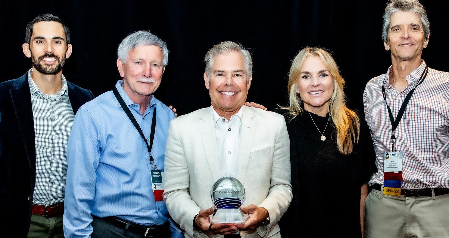
BSMAR would not be what it is today without the community that builds each other up and drives the field forward. Nobody exemplifies this attitude more than Adam Hutchinson, the Recharge Planning Manager at Orange County Water District and the 2026 recipient of the Herman Bouwer Award. Adam received the award to recognize his leadership in advancing recharge planning and implementation. He emphasized the importance of the MAR “tribe” in being positive, collaborative, and so vital in the water community. It was an honor to present the award to Adam and to collaborate with him in orchestrating the conference.
Our Day 1 reception delivered on community in a big way. With carnival-style games, poster presentations, and the baby goats that more than lived up to the hype, we all learned a few things, made a few new friends, and didn’t take ourselves too seriously. The goats, unsurprisingly, stole the show!

isions
The conference wrapped up by getting out into the field, just in time for the rain to clear up.
Our field trip took us north to the Dunnigan Water District, where landowners and the water district put their MAR where their mouth is to collectively address overdraft in the South Colusa and Northern Yolo regions. Standing in a newly planted orchard, we watched reverse tile drains in action, a deceptively simple concept that flips traditional drainage on its head to push water back into the ground. It’s the kind of practical solution that makes you realize the opportunities that can be found within our existing systems.
The tour continued to the City of Woodland, where we visited an aquifer storage and recovery (ASR) well. If Dunnigan showed the surface side of recharge, Woodland highlighted what’s happening below ground through creative engineered
systems designed to store water when it’s available and recover it when it’s needed. Seeing both approaches in one morning underscored just how broad the MAR toolbox has become.
The launch of NASA’s Artemis II mission was broadcast on screens in the main ballroom during the second day of the conference. This launch was an unexpected but fitting reminder that big leaps are built through years of planning, testing, and people willing to keep pushing forward to overcome challenges. BSMAR19 had that same feeling. The MAR community has spent years developing science, building partnerships, and proving what is possible. Now the work is to implement and scale it. As we left Sacramento, I felt like we were launching into the next phase for managed aquifer recharge. To infiltration and beyond!
Garrett Rapp, David Pyne, Adam Hutchinson, Megan Hutchinson, Mike Milczarek


SGMA TECHNICAL PLANNING AND SUPPORT...
•Groundwater and Surface Water Modeling to evaluate:
- Saltwater Intrusion and Barriers
- Interconnected Surface Water
-Recycled Water Recharge
- Safe Yield
-Aquifer Storage and Recovery
• Risk and Uncer tainty Analysis
•Aquifer Characterization
•Well Design and Construction Oversight
• Title-22 Permitting and Regulatory Support
• Air Quality Permitting, Modeling, Greenhouse
Gas Quantification and Reduction
Contact one of our California water resource experts:
Abhishek Singh, PhD, PE asingh@intera.com 424.275.4055
Trey Driscoll, PG, CHG tdriscoll@intera.com 760.415.1425
Ryan Alward, PG, CHG ralward@intera.com
530.680.5756
Tyler Hatch, PE thatch@intera.com
530.515.7129
Environmental Consulting and Engineering
At LWA, we understand that groundwater is vital for California’s water future. We’re here to help communities manage this precious resource wisely and in line with state regulations.
Home Office
Davis, CA | 530.753.6400 with regional offices in Berkeley, San Diego, San Luis Obispo, Santa Monica, Seattle, Ventura, and Yreka
www.inter a.com
Hydro Visions

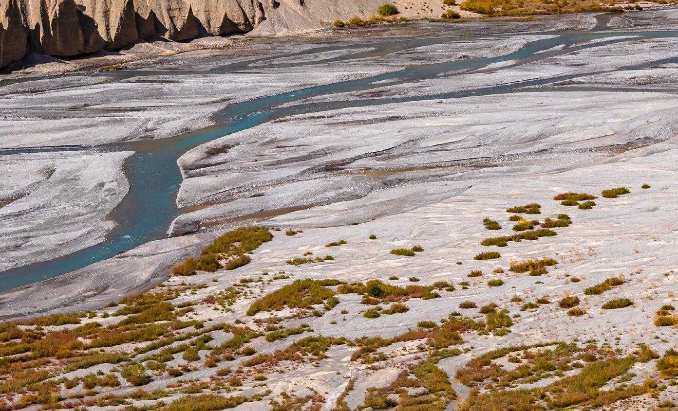
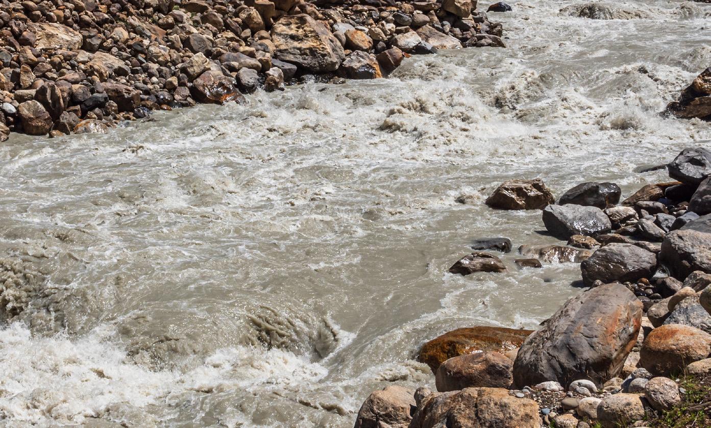
GeoH2oMysteryPix
by Chris Bonds, GRA, Sacramento Branch Member
at
Large
GeoH2OMysteryPix is a fun addition to HydroVisions that started in Fall 2022. The idea is simple; I provide one or more photograph(s) and two questions, along with a hint, and HydroVisions’ readers email in their guesses.
In a future issue of HydroVisions, I will share the answer(s) along with some brief background/historical information about the site photo(s) and acknowledge the first person(s) to email me the correct answer(s).
GRA looks forward to your enthusiastic participation in GeoH2OMysteryPix. SPRING 2026 ANSWERS
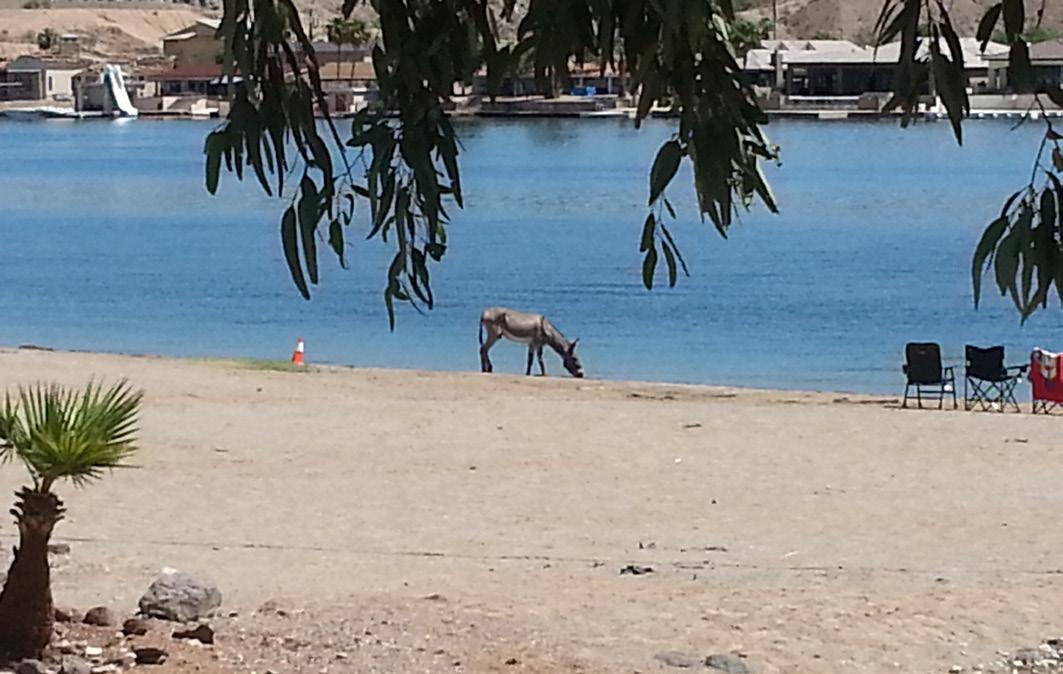
What is this? Where is it Located?
Hint: In the general vicinity of this cool water pix lies a historically significant piece of CA water infrastructure.
Congratulations to Trevor Pontifex, PG, Hydrogeologist, Montgomery & Associates for providing the following correct response to the Spring 2026 2026 GeoH2OMysteryPix
Questions:
TP: “My guess is Colorado River downstream of Parker Dam. That area has long interested me, but I’ve only visited it on Google Maps. I learned today that Parker Dam is the world’s deepest dam and 90 years old. Its creation formed Lake Havasu.”
Background/History: The above photo is of a wild burro drinking from the Colorado River at Emerald Cove downstream of Parker Dam, Lake Havasu, and the start of the Colorado River Aqueduct (CRA). The view is easterly towards Arizona. Fun Fact: Wild burros frequent this area of the Colorado River and are direct descendants of pack animals left behind by prospectors of the early 1900s gold rushes.
Parker Dam, about 10 miles northeast of this photo, was built from 1934-38 by the US Bureau of Reclamation. The dam impounds the Colorado River forming the reservoir, Lake Havasu, which is used for water supply and hydropower. The dam is a concrete-arch structure that is 320 feet high, 856 feet in length, and has a storage capacity of about 646,000 acre-feet. Most of the structure (235 feet) is located below the riverbed with a deep excavation necessary to reach bedrock upon which the dam foundation was built. The portion of the dam above the foundation is 85 feet tall, making it the only dam in the world that stands more underground than above ground. Lake Havasu is the water source for the CRA, and also for the Central Arizona Project, which began construction in 1973. The CRA was constructed from 1933-35 by the Metropolitan Water District of Southern California, and it is a 242-mile-long water conveyance spanning from Lake Havasu to Lake Mathews (initially, Lake Cajalco) in Riverside County. The aqueduct was the largest construction project in Southern CA during the Great Depression and employed 30,000 people and as many as 10,000 at one time. The CRA began conveying water in early 1939. In 1955, the CRA was deemed by the ASCE as one of their Seven Modern “Civil Engineering Wonders”. Lastly, the CRA was featured by Huell Howser in California’s Gold in February 2007; a good watch if you’ve not seen it before! As Huell would say…That’s Amazing…


isions

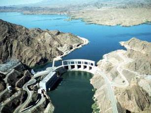
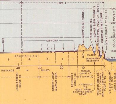
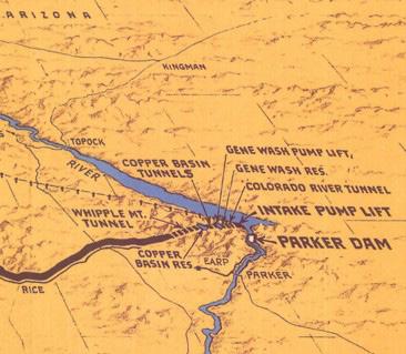
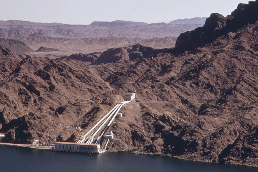
SUMMER 2026 QUESTIONS
References:
https://en.wikipedia.org/wiki/Colorado_River_Aqueduct# https://en.wikipedia.org/wiki/Parker_Dam https://www.cap-az.com/about/history-of-cap/ https://blogs.chapman.edu/huell-howser-archives/2007/02/03/californiaaqueduct-special-californias-gold-001/
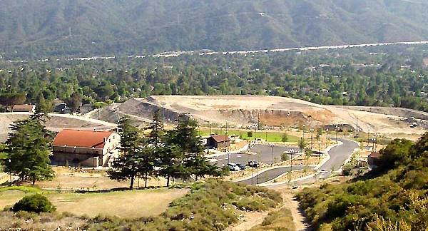
What is this? Where is it Located?
Hint: A historically significant place in the foothills of the San Gabriel Mountains.
Think you know What this is and Where it is Located? Email your guesses to Chris Bonds at goldbondwater@gmail.com
Parker Dam, Lake Havasu (background) and the Colorado River (foreground)
Cross Section of the first 40+ miles of the CRA
Schematic of the first 40+ miles of the CRA
Whitsett Pumping Plant is the intake for the CRA
Hydro Visions

PartinG sHot
by John Karachewski, PhD, DTSC PG & CHg - retired
The Ancient Bristlecone Pine Forest in the White Mountains of eastern California include the world’s oldest individual living trees (some over 4,800 years old). To put their ages in perspective, the oldest giant sequoia trees of the western Sierra Nevada are 2,600 years old and some of bristlecone pines were seedlings before the ancient Egyptians built their pyramids at Giza. The species is endemic to the Great Basin mountains of eastern California, Nevada, and Utah and typically grows at elevations between 9,500 and 11,800 feet.
Tree-ring dating (dendrochronology) of the bristlecone pines was established in the late 1950s by Dr. Edmund Schulman of the University of Arizona. By studying the bristlecone pines, he was able to interpret past climates because wetter and warmer years generally lead to wider annual growth rings. By matching variations in tree rings in living trees to recently dead trees, dendrochronology has extended the paleoclimate record back to 8,850 years ago. Radiocarbon dating of still older dead trees and downed wood has allowed scientists to reconstruct nearly all of the Holocene paleoclimate record back to approximately 10,000 years ago.
The bristlecone pines grow mostly on dolomite of the latest Proterozoic Reed Formation (about 570 million years old). The bristlecone pines grow in a setting of low rainfall, cold temperatures (annual average slightly above freezing), and persistent wind. The dolomite also weathers to an alkaline soil that is deficient in important nutrients, such as phosphorus. Bristlecone pines tolerate these harsh conditions, although their growth is slow.
The gnarled, windswept, and mostly dead bristlecone pines grow exceptionally slowly, sometimes adding only half an inch of girth per century under the thin bark. The lack of moisture and essential nutrients suppress competitors on the south facing slopes shown in this photo. Thus, the bristlecone pines are widely spaced, and underbrush is lacking both of which contribute to tree longevity and low incidence of fire. On north-facing slopes which retain snow for longer periods and undergo slower evaporation, bristlecone pines grow closer together and on all rock units, including sandstone, limestone, and granite.
Photographed along the Cottonwood Basin Overlook Trail near the Patriarch Grove by John A. Karachewski, PhD, on June 3, 2026. The approximate GPS coordinates of the photograph are 37.52647° and -118.19597 ° and an elevation of 11,335 feet. Vignette 25 in Geology Underfoot in Death Valley and Eastern California, Second Edition (2022) by Allen F. Glazner, Arthur Gibbs Sylvester, and Robert P. Sharp describes the geology and biology of this area. The Ancient Bristlecone Pine Forest is generally accessible from Memorial Day through the end of October. Current conditions and information about visiting this area are available at the Inyo National Forest website.
isions

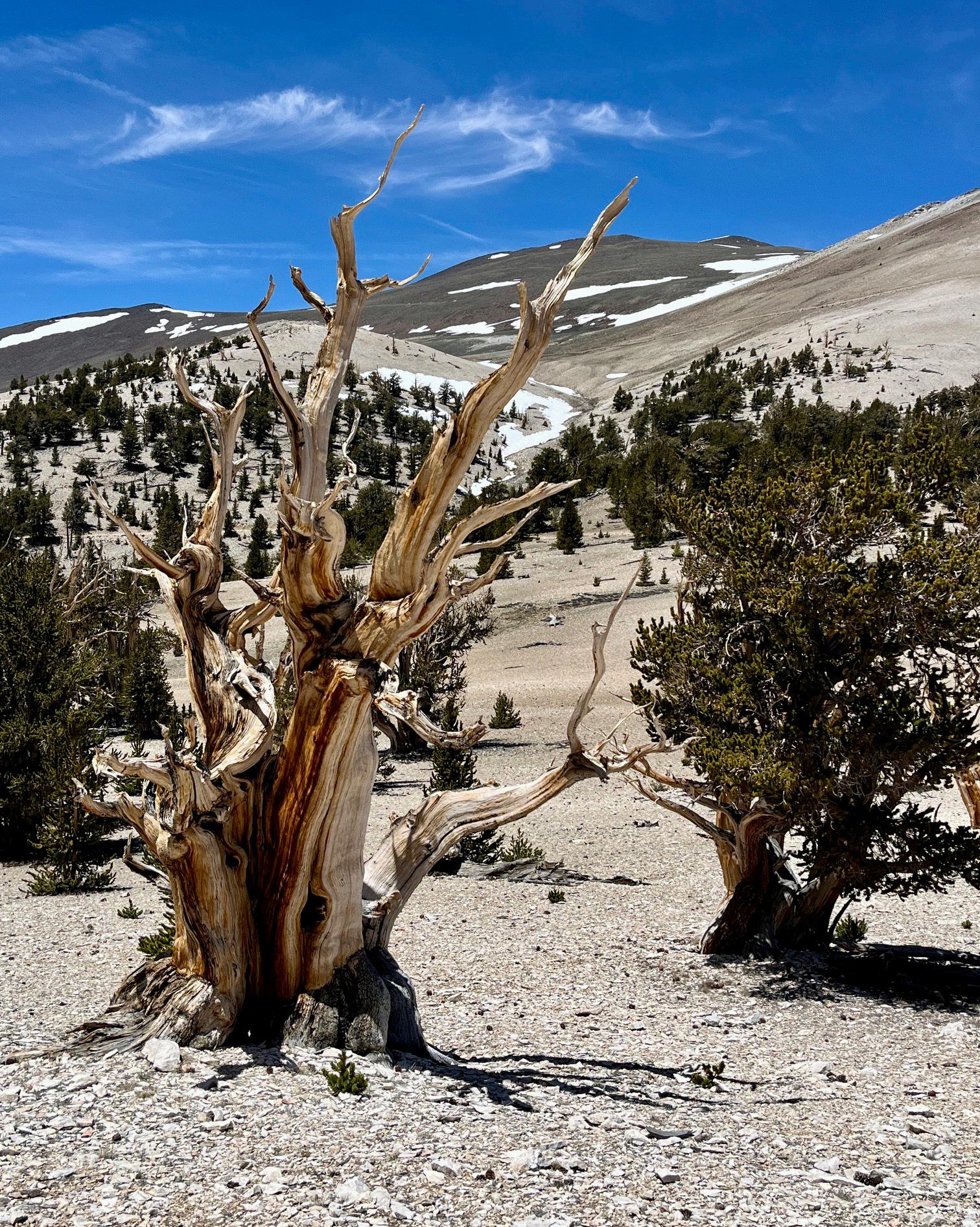
t H ank y ou to o ur c ontributors
Dominick Amador, PE, is a Senior Project Manager at Woodard &. He specializes in integrated surface water–groundwater modeling systems, with a focus on connecting technical analysis to real-world implementation. He integrates watershed-scale analysis with local water management priorities to develop and implement actionable adaptation strategies.
Hanni Blair is a hydrogeologist specializing in groundwater modeling. She has expertise in variable density flow and transport simulation, seawater intrusion analysis, and groundwater sustainability planning. She has supported groundwater sustainability efforts throughout California, with a particular focus on seawater intrusion mitigation and integrated hydrologic modeling in the Salinas Valley.
Jim Blanke is a professional engineer, professional geologist, and certified hydrogeologist with over two decades of extensive experience in groundwater management in California. He has authored groundwater sustainability plans, developed technical guidance for various groundwater efforts, developed and implemented groundwater ordinances, expanded monitoring networks, and provided technical assistance for water transfers, recharge, and banking.
Chris Bonds is a Senior Engineering Geologist (Specialist) with the California Department of Water Resources (DWR) in Sacramento. Since 2001, he has been involved in a variety of statewide projects including groundwater exploration, management, monitoring, modeling, policy, research, and water transfers. Chris has over 31 years of professional work experience in the private and public sectors in California, Hawaii, and Alaska and is a Professional Geologist and Certified Hydrogeologist.
Erik Cadaret is an Associate Geologist with West Yost Associates and joined the GRA Board of Directors in 2021. Erik’s role with West Yost is to support various groundwater technical projects for clients within the state of California, management of a GSA in northern California, and support business development efforts to engage new clients. Erik loves being a part of GRA because it provides an outlet to collaborate with some of the greatest minds in groundwater.
Rick Cramer, PG, is a Senior Principal Geologist for Geosyntec Consultants with over 30 years of experience as a consultant in the groundwater industry focusing on applying advanced geologic methods to improve hydrogeologic conceptual site models by defining the subsurface geologic heterogeneity.
Pete Dennehy, PG, CHG, specializes in hydrogeologic investigations and water resource planning primarily for California groundwater basins. He has over a decade of experience complying with the Sustainable Groundwater Management Act (SGMA) by developing and implementing Groundwater Sustainability Plans (GSPs). His technical work touches on all aspects of GSP implementation.
Trey Driscoll, PG, CHG, is the Managing California Director of Water Resources & Supply for INTERA. We provide stewardship and innovation to state and local water agencies for a sustainable tomorrow focused on water planning, supply development, recharge (ASR and MAR) and decision-support. Trey enjoys collaborating with fellow GRA members to help shape the future of water resources in California.
John Ellis is a Principal Hydrogeologist with 16 years of experience specializing in groundwater modeling, land subsidence, and water resources planning and management. His project work is focused in California, Texas, and Oklahoma, where he leads the development of local to regional scale groundwater flow and subsidence models and supports Sustainable Groundwater Management Act (SGMA) implementation.
Hannah Fitzpatrick, GIT, specializes in hydrogeologic investigations and aquifer characterization for California groundwater basins. She applies distributed fiber optic sensing (DTS/DAS), aquifer testing, and hydrostratigraphic analysis to water resources and groundwater modeling projects. Her technical work supports Managed Aquifer Recharge (MAR) planning, hydrogeologic conceptual model development, and geophysical data interpretation for subsurface characterization.
Hiroko Hort, PhD, PE is an engineer with GSI Environmental Inc. Her area of expertise includes environmental data analysis, computational groundwater/surface water modeling, infectious disease modeling, and soil/hydraulic property characterization. Many of her recent studies focus on PFAS data analytics to understand the retardation scheme as well as support the modeling the fate and transport of PFAS in the groundwater and vadose zone.
John Karachewski, PhD, retired recently from the California-EPA in Berkeley after serving as geologist for many years in the Geological Support Branch of the Permitting & Corrective Action Division for Hazardous Waste Management. He leads numerous geology field trips for the Field Institute and also enjoys teaching at Diablo Valley College. John enjoys photographing landscapes during the magic light of sunrise and sunset. Since 2009, John has written quarterly photo essays for Hydrovisions.
Jenny Lagerquist, PE, brings nearly two decades of experience serving in environmental consulting and governmental roles, including more than a decade as a PFAS subject matter expert supporting complex site investigations and response actions across multiple Department of Defense installations.
Raghavendra Suribhatla Maruti, Ph.D., P.E. is a Technical Expert with Haley & Aldrich and a licensed Professional Civil Engineer focused on coastal groundwater management, seawater intrusion control, applied research, and climate resiliency. He serves as the California modeling manager for H&A’s applied research and climate resiliency projects, integrating hydrogeologic interpretation, numerical modeling, and decision support for complex water-resource challenges.
Jordon Navarrot is the Manager of Dunnigan Water District and Deputy Manager of Reclamation District 108. He brings a strategic, data-driven approach to water resource management - balancing financial stewardship with long-term environmental resilience. His work bridges hands-on operational experience with regional water policy, advancing practical and innovative solutions that strengthen the future of California agriculture.
Nick Newcomb is a Senior Hydrogeologist specializing in integrated hydrologic modeling, land subsidence, and stream-aquifer interaction. His work focuses on the development and application of regional models to support Sustainable Groundwater Management Act (SGMA) implementation, water resource planning, and subsidence mitigation. He has extensive experience in the planning and implementation of Groundwater Sustainability Plans throughout California.
Kait Palys is a Senior Water Resources Scientist with INTERA Inc., supporting groundwater sustainability planning, water resources management, and stakeholder engagement throughout California’s San Joaquin Valley. Her work focuses on implementing the Sustainable Groundwater Management Act by connecting technical analyses with regulatory compliance.
Garrett Rapp, PE, is a senior engineer with West Yost in Sacramento, California. His work focuses on surface water and groundwater hydrology, groundwater modeling, managed aquifer recharge, water rights, and groundwater sustainability planning and implementation.
Angie Rodriguez-Arriaga is a Geologist at West Yost Associates, where she supports groundwater sustainability, hydrogeologic analysis, and data-driven reporting for agencies across California. She is a co-lead of GRA’s Diversity, Equity & Inclusion Committee and is passionate about uplifting diverse voices in water management. Angie is committed to making groundwater science more accessible, equitable, and collaborative.
John Stults, PhD is an Environmental Engineer with CDM Smith located in Bellevue Research & Testing Laboratory. He completed his PhD research at Colorado School of Mines, studying the transport mechanisms of PFAS in the vadose zone. He specializes in PFAS transport and treatment assessments, numerical modelling, and scalable data analytics.
Chad Taylor is the Vice President and Principal Hydrogeologist at Todd Groundwater specializing in groundwater supply development, management, and monitoring on all scales from individual property to basin wide.
Gus Tolley, Ph.D., specializes in groundwater hydrology, numerical modeling, groundwater–surface water interactions, contaminant transport, GIS mapping, and workflow automation, with deep experience in developing, calibrating, and analyzing integrated hydrologic models for agricultural basins.
Faran Torres, PhD – Experienced Water Resources Engineer with a demonstrated history of working in the Hydrogeology industry. Skilled in Numerical Modeling using a wide variety of software, Groundwater Engineering, Fieldwork, Treatment Technology, Site Remediation, and application of ML (Python) in hydrogeology. Strong research professional focused on Hydrogeology from the University of Guelph, and G360 institute for groundwater research.
Marcus Trotta is a Principal Hydrogeologist with Sonoma Water and serves as plan manager for the Santa Rosa Plain, Petaluma Valley and Sonoma Valley Groundwater Sustainability Agencies. In these roles he leads technical studies and monitoring of riverbank filtration facilities and basin-scale groundwater resource studies and management programs.
Patrick Wickham P.G., C.Hg, is a hydrogeologist specializing in groundwater management, modeling, and data analysis. His expertise in hydrogeology, water supply planning, and programming allows him to develop novel approaches to complex water resource challenges. He has contributed to groundwater sustainability planning across the western U.S., with a recent focus on the California Coast.
Kyle Young, PhD, is a coastal hydrogeologist with academic experience in groundwater physics, hydrologic processes, and geophysics consulting. His expertise in groundwater physics and coastal hydrogeology derives from extensive training and research quantifying submarine groundwater discharge. Dr. Young has significant experience utilizing hydrologic modeling software and Geographic Information Systems (GIS) to characterize surface water flows for Managed Aquifer Recharge (MAR) decisionmaking.
Thank
CORPORATE SPONSORS

EVENT SPONSORS




COMMUNICATIONS SPONSORS



Roscoe Moss Company
Stults
Stefanie Shea
Assadi
Meeta Pannu Anaheim, CA
Rivers
Community Water Center working on drought, nitrate, and climate change related drinking water issues. Originally from San Diego, Kjia attended the University of California, Santa Barbara to obtain Bachelor of Arts in Environmental Studies and Political Science. During her time at UCSB, Kjia was to learn about environmental justice issues and vulnerable communities are often left out of the policy making process.
Hydro Visions