advantage. Understanding the pros and cons based on terrain, cellular availability, and other accuracy needs can help surveyors make informed decisions to optimize their workflows and deliverables.
FEATURES
Robotic Construction
The construction industry has reasons that it is slow to adopting robotic technologies, but a German professor is trying to build up autonomous construction.
GNSS Corrections
For surveyors, choosing the right GNSS correction services can be a daunting task that requires consideration of many elements.
Publisher Shawn Dewees shawn.dewees@xyht.com
Editor-in-Chief Jeff Thoreson jeff.thoreson@xyht.com
Director of Sales and Business Development Chuck Boteler chuck.boteler@xyht.com
Creative Director Ian Sager ian.sager@xyht.com
Accounting and Classifieds Angie Duman angie.duman@xyht.com
Editor, Field Notes Eric Gladhill eric.gladhill@xyht.com
Contributing Writers Towfique Ahmed Tim Burch Marc Delgado Jeff Lucas Tony Nettleman Gavin Schrock
Partners and Affiliates
Parcel Mapping Tools
Part 2: Tools to create parcel maps for any reason have made great strides.
Surveyor’s Corner
The surveyor and the “Geodesy Crisis.”
The Business of Surveying
Beyond
Legal Boundaries
How to win a boundary dispute case.
Located Located Located
Mapping Your World | Digital Twins | GNSS | New Products
Compiled by Jeff Salmon
Europe Kickstarts its Own Sat-Com
THE EUROPEAN UNION WILL SOON BOAST ITS OWN secure communication satellites system similar to Starlink with the signing of a new space contract in Brussels, Belgium, in December.
IRIS², short for Infrastructure for Resilience, Interconnectivity, and Security by Satellites, will be composed a multi-orbital constellation of 290 satellites that will provide Internet connectivity to Europe, including connectivitydeprived zones, using both Medium Earth Orbit (MEO) and Low Earth Orbit (LEO) satellites. Launch plans for the first IRIS² satellites will be in 2029.
Aquatic Treasure Hunters Take Note
A LOW-COST SUBMERSIBLE DRONE HAS JUST ADDED a new treasurehunting upgrade. Chasing Innovation has introduced an upgrade to its affordable underwater drone, the Dory. The Chinese company is now offering a new version of the small remote-control sub, complete with a joystick remote, metal detector, and treasure-collecting net. Called the Dory Explore, the new model is identical to the standard Dory—but adds an attached metal detector and net.
The 1.1-kilogram (2.4-pound) drone can dive to a maximum depth of 15 meters (49 feet) and is linked via an electrical cable to a Wi-Fi buoy which is
The project consortium is composed of major European satellite and communication companies, including Airbus Defence and Space, Deutsche Telekom, Orange, and Eutelsat SA.
“The IRIS² program is a landmark initiative that embodies Europe’s commitment to digital sovereignty, resilience, and strategic autonomy,” said Eva Berneke, chief executive officer of Eutelsat.
—Marc Delgado, marc.delgado@xyht.com
towed along the surface. Users control the Dory Explore (and view the realtime output of its 1080P high-definition camera) via an iOS/Android app that wirelessly communicates with the buoy.
When sand-covered ferrous metal is detected, users are alerted by a flashing red LED on the detector itself, which can be seen in the drone's camera feed. The net simply gets clipped onto the detector as needed.
If you are looking to join the ranks of legendary treasure hunters like Mel Fisher, but are a little light in the wallet, then at just $509 the Dory Explore is for you.
VertiGIS Studio Offers Low-code/No-code GIS App Development
VERTIGIS STUDIO IS A SUITE OF TOOLS DESIGNED TO EMPOWER organizations with the ability to create robust GIS applications without writing a single line of code. Thousands of organizations have already said goodbye to the cumbersome effort of grappling for developer assistance to build and maintain their apps. VertiGIS Studio offers a low-code/no-code environment with a collection of pre-built and easily configurable widgets, streamlining the creation process and bringing GIS to the forefront of an organization's success, making it accessible for people who rely on spatial data in comprehensible ways.
Typical applications include:
• Asset and document management: Improve data accuracy and save substantial time
• CAMA, imagery, and data processing: Gain actionable insights within your apps
• Citizen engagement: Enable self-service capabilities to reduce the burden on GIS teams
• Process automation: Regulatory adherence without the tedious, manual oversight
Stonex’s New X40GO SLAM Laser Scanner
THE X40GO IS A COMPACT SYSTEM PROVIDING HIGHPRECISION point cloud data, based on SLAM (simultaneous localization and mapping) technology. With a 70-meter range, its lidar orientation has been designed to maximize coverage and a built-in 12-megapixel camera provides texture information to the 3D model.
An affordable and simple solution, X40GO offers a host of features including Geotagging, real time preview, automatic control point measurement, and high-performance computation. Post-processing is handled by the included GOpost
software for colorizing point clouds and creation of panoramic images. Users can also import control points to georeference the point cloud. Also bundled is GOapp, Stonex SLAM’s dedicated mobile application to manage projects, real time point cloud display, image preview, firmware upgrade, and other operations. The APP runs on either Android or iOS operating systems.
The X40GO, combined with bundled software, is a superior solution for interior surveys with floor plan generation and BIM.
EXPECT 2025 TO CONTINUE TO BE A BUMPER YEAR in space events and launches as more countries and private companies join the race to reach beyond the skies. In Januarythe launch of the Blue Ghost 1 lunar lander marked the first privately funded U.S. spacecraft designed to land on the surface of the moon.
In February, Butch Wilmore and Sunni Williams, astronauts from the International Space Station, return to Earth, and in March NISAR (NASA-ISRO Synthetic Aperture Radar) was launched to scan the Earth’s land and ice surfaces, twice every 12 days.
And there’s plenty more to come:
May: 50th anniversary of the European Space Agency.
July: Galileo Emergency Warning Satellite System will transmit alert messages to smartphones or other devices that can receive Galileo signals.
August: Launch of Sentinel-1D, a two-satellite constellation carrying advanced radar instruments will provide all-weather imagery of the Earth’s surface.
Third Quarter: First flight of Ariane 64, Europe’s new rocket which has four boosters.
Fourth Quarter: Cluster-1 satellite will undergo the world-first ‘targeted reentry’ to make sure that any part of the spacecraft that survives the return to Earth's atmosphere will fall over the open ocean.
—Marc Delgado, marc.delgado@xyht.com
The Year Ahead in Space
St. Peter’s Basilica Gets a Digital Twin
THE VATICAN COLLABORATED WITH MICROSOFT to create a digital copy of the St. Peter’s Basilica using artificial intelligence technology.
It took experts four years to capture some 400,000 high-resolution images using cameras, drones, and lasers of the entire religious complex. Microsoft’s AI technology stitched the photos together to create a 22-terabyte digital mosaic.
The project to build the basilica’s digital copy will now allow would-be visitors to virtually explore the Basilica in time for the 2025 Jubilee, while at the same time helping architects and engineers to identify structural problems. The Vatican expects more than 30 million pilgrims during this year's jubilee, an event celebrated every 25 years.
—Marc Delgado, marc.delgado@xyht.com
Amsterdam Drone Week & Commercial UAV Expo
April 8-10
Amsterdam, NL
Carlson User Conference
May 6-8
Maysville, KY
Xponential/AUVSI
May 19-22
Houston, TX
CGA Conference: Geography of Digital Twins
May 22-24
Cambridge, MA
GEO Business
June 4-5
London, UK
Hexagon LIVE
June 16-19
Las Vegas, NV
Commercial UAV Show
September 2-4
Las Vegas, NV
Trimble Dimensions
November 10-12
Las Vegas, NV
Trimble, Qualcomm Partner on Positioning Tech for Autonomous Vehicles
TRIMBLE HAS EXPANDED ITS COLLABORATION WITH Qualcomm Technologies to offer precise positioning solutions for automated vehicles, ranging from passenger cars to heavy trucks.
The partnership will integrate Trimble's ProPoint Go positioning engine with Qualcomm's Snapdragon Auto 5G Modem-RF Gen 2, to provide positioning accuracy within 10 centimeters.
The joint solution is expected to be available in vehicles by 2028, supporting Level 2+ and potentially higher levels of automated driving (AD) applications. It will enable high-accuracy positioning for advanced driver assistance systems (ADAS) and cellular vehicle-to-everything (C-V2X) applications for automotive manufacturers and Tier-1 suppliers, Trimble claims.
Saildrone to Map CoastalFlorida's Waters
SAILDRONE HAS BEEN SELECTED BY THE Florida Department of Environmental Protection (FDEP) to map Florida’s coastal waters in the Gulf of Mexico as part of the Florida Seafloor Mapping Initiative (FSMI), a multiyear effort to provide statewide stakeholders with accessible, high-quality, and high-resolution seafloor data of Florida’s coastal waters within the continental shelf.
Updated mapping data of coastal systems is critical for protecting offshore infrastructure, habitat mapping, restoration projects, emergency response, coastal resilience, and hazard studies for the state’s citizens.
Saildrone has been tasked with collecting high-resolution multibeam data in a region known as Middle Grounds. The mission will use two 10-meter Saildrone Voyager uncrewed surface vehicles (USVs) equipped
with NORBIT WINGHEAD i80s echo sounders for high-resolution mapping and radar, AIS, and cameras for maritime domain awareness. Saildrone will map 2,817 square kilometers of seafloor, approximately 130 kilometers northwest of St. Petersburg.
“Mapping the Florida coastline is vital for understanding our dynamic coastal environments, supporting sustainable resource management, and enhancing resilience against extreme weather events,” said Brian Connon, Saildrone VP Ocean Mapping. “FSMI will provide critical insights that empower policymakers, researchers, and local communities to protect vital ecosystems and infrastructure along Florida’s coasts. Saildrone USVs efficiently and safely collect high-resolution bathymetric data while minimizing environmental impact.”
Teledyne Geospatial Introduces New Topobathy Solution: ‘Fathom’
TELEDYNE GEOSPATIAL HAS INTRODUCED FATHOM, a fast and intuitive coastal mapping solution. Fathom is comprised of a lidar sensor for deep and shallow water bathymetry. Also included is a built-in topographic lidar and a multispectral camera for the most complete coastal survey at a coverage of 50 square kilometers per hour. Fathom delivers data quickly by leveraging real-time quality control with onboard and scalable processing with a CARIS workflow.
Fathom is engineered to address common challenges in topobathy projects: cost and complexity. Designed for use in small aircraft for cost reduction, Fathom also features real-time quality control for confidence in data collection with onboard in-air software. Simplified post-processing software, Fathom Flow, provides fast data turnaround to deliver projects quickly. Compared to traditional methods, Fathom captures data 45 times more productively in the intertidal zone, according to the manufacturer.
Carlson Software Announces the Purchase of DotSoft
CARLSON SOFTWARE HAS BOUGHT THE ASSETS OF DOTSOFT, which include numerous CAD-related products such as ToolPac, LidarTools, MapWorks, RevitOffice+, PDF2DWG, and others. Terry Dotson, the author of all DotSoft products, was a fully self-taught programming expert who developed hundreds of utility programs to make the work of surveyors, engineers, mapping technicians, and CAD operators in general more productive. His programs have functioned as add-ons to AutoCAD, Intellicad, and BricsCAD. Terry had worked directly for Carlson for more than a decade, bringing his products to the company, before returning to private business.
Richer GIS Layer Now
More Accessible
MAPMAKERS CAN NOW MAKE USE OF popular NASA imagery products right on their desktops via Esri’s ArcGIS Living Atlas of the World, all in GIS format.
The newly accessible NASA dataset includes true-color and corrected-reflectance Earth imagery from the Moderate Resolution Imaging Spectroradiometer (MODIS) instrument, which captures the image of the Earth every one to two days. MODIS data can be used to track land cover changes over time, such as monitoring deforestation and flooding. In the United States, it is being used to map wildfires.
While NASA imagery data have always been publicly available, this recent partnership with Esri is a boon for GIS users. Previously, clients themselves had to download and process the imagery, requiring considerable computing resources and time. By making their data available in ArcGIS Living Atlas of the World, NASA makes it far easier for GIS practitioners to access highquality imagery datasets in a plug-and-playable GIS format.
—Marc
Delgado, marc.delgado@xyht.com
RIEGL’s New Long-range Scanner: VZ-4000i25
RIEGL’S NEW LONG-RANGE SCANNER FEATURES on-board processing, one-touch-button operation, customized workflows, and pre-settings, as well as real-time registration enabled by GNSS/IMU to provide a fast and efficient workflow from data acquisition to post-processing results.
The unit provides remarkable long-range performance of up to 4,600 meters at eye-safe operation in laser class 1. The IP64 certification ensures that it can be used in harsh environments.
RIEGL’s Ultimate lidar technology provides multipletarget capability and valuable data attributes for every measurement.
The versatility of the scanner allows use in various applications and survey routines. An internal camera, internal IMU for pose estimation, an optional external GNSS RTK receiver, support for user apps, and pre-installed RIEGL apps are further key features. Integrated WiFi, high-speed data download via TCP/ IP, automatic and fast data transfer with CF-express card, cloud data synchronization via internet, and exchange formats for further analysis provide superior connectivity.
Hardwired to build
This cybernetics engineer is laying the groundwork for robust automated systems that will help us construct our future spaces. Her spider-crane robots are already showing how it’s done.
By Marc M. Delgado, PhD
Dr. Anja Lauer is on a mission to help the construction industry build better. As the founder of the Department of Construction Robotics at the University of Stuttgart in Germany, she juggles her role as a researcher, professor, and leader of her department, while at the same time creating robots that can assemble building components in construction sites.
“Current approaches to automated building do not use the full potential of construction robotics,” says Lauer, who has a doctorate degree in engineering and a masters in cybernetics. That’s why her longterm vision for her department is to design robust robotic construction systems consisting of robots and end-effectors [arm grippers, tools, or sensors attached to robotic arms], building elements and
their connections, as well as automated construction processes.
“These are the main components which have to be considered together to create an efficient and impactful way of constructing,” she adds.
For example, Lauer was responsible for the automated on-site assembly of the livMatS Biomimetic Shell building, a 345-square-meter lightweight timber structure in a project carried out in collaboration with her university and the University of Freiburg.
As part of the project’s aim to achieve sustainable architecture via integrative approach to design and construction, Lauer led the development of two robotic spider-crane manipulators with end-effectors that automatically assembled the livMatS building’s wooden parts called cassettes on its actual site. To be able to do that, each robot had a specific task: one picked and placed a cassette into its corresponding position, while the other screwed the assembled cassettes together. Each cassette weighed about 100 kilograms (220 pounds).
For that project, Lauer had the chance to work on a large variety of topics in robotics, starting from “equipping the large-scale manipulators with hardware such as sensors, and participating in the development of a screwing end-effector, to writing the whole program that runs on the manipulator including communication, logic, signal processing, modeling, state estimation, path planning, trajectory generation, and feedback controllers,” she says.
collision-free path planning during the automated assembly of the components.
“Having a digital twin of the construction site and of the planned construction process is really beneficial for automation,” she says. “That’s because robots need to know which tasks to execute in which order, including the position information. Ideally, this data can be extracted from a BIM model.”
The livMatS timber building now stands at the Freiburg University campus, and it is impressive to know that robots helped build it. Yet despite the technical progress in the science of robotics as demonstrated by the livMatS project, the construction sector at large still seems to be slow in adopting digitization and automation. “Construction has the lowest degree of digitization compared to other sectors,” says Lauer.
a sector that has traditionally low profit margins. Aside from that, productivity in the construction sector has languished in recent years due to labor shortages, while at the same time its environmental footprint continues to increase worldwide.
It is quite difficult to change prevailing business models and create new opportunities in the sector when it is sluggish to apply new digital technologies.
Lauer, however, is undaunted by these setbacks and is betting on automation to help shore the industry up. Growing up,
There are many factors behind this holdup, but mostly because the industry is fragmented.
Lauer and her team also used geospatial tools to accomplish their work. Geodetic engineers from the University of Stuttgart’s Institute of Engineering Geodesy (IIGS) developed a robot total station network to endow precise positioning.
“The idea was to use the robotic total stations as the main sensors for positioning as they provide real-time measurements with an accuracy of three millimeters throughout our large workspace,” says Lauer. The total station together with the Building Information Model (BIM) of the structure were then employed to ensure
“The construction sector is made up of many small, medium-sized, and large companies, while at the same time countries have different construction norms, standards, requirements, and needs,” she says. “There is almost no standardization.”
Lauer also adds that it is quite difficult to automate each and every piece of construction work because building elements have different materials, shapes, sizes, weights, and connections.
“Unlike a series production that is common in the automotive sector, there are fewer repeatable tasks in construction. Therefore, at the moment, a customized and automated solution for every building task would be rather cumbersome and expensive.”
And cost is an important issue for
she was inspired to study engineering cybernetics by her great-uncle who was also a professor. Then a master’s project with mobile robots for a scrapyard in Japan made her even more interested in the automation of large-scale manipulators doing construction tasks.
“Robots could make the construction of novel environmentally friendly buildings economically feasible,” says Lauer. “By making improvements in digitization and automation, we can have a big impact globally.”
(This interview with Lauer has been edited and condensed.)
In a nutshell, how were robots used in the livMatS Biomimetic Shell building project? There are 127 hollow cassettes that form the shell of the livMatS building, and all of them have individual shapes, sizes, and forms. Since they fit together like a puzzle, first they must be fabricated with very low
Dr. Anja Lauer is a cybernetics engineer and the founder of the Department of Construction Robotics at the University of Stuttgart in Germany.
tolerances. My colleagues achieved this using pre-fabrication robots. These pre-fabrication robots were installed inside a laboratory hall where they sawed the parts, placed
the components together, and glued them. After that, on-site assembly robots worked in the construction site. They were designed to be suited for the large exterior workspace and higher payloads and have end-effectors which were used to place and connect the pre-fabricated components. [Search ivMatS Biomimetic Shell on YouTube to see the robots at work.]
The use of robots has been predicted to modernize the construction industry. What do you think are the main advantages of integrating robots in construction projects?
First would be on productivity and efficiency. Automation allows us to optimize the execution of construction tasks, for example in terms of time or energy. As robots can work 24/7, construction time can be reduced. Also, one human operator can supervise several
repetitive tasks with high accuracy. If for example, screws have to be inserted at specific angles at specific positions, it is very difficult for human workers to achieve the exact angles. A robot and its end-effector on the other hand, can be programmed to achieve tasks with high quality. And third is better working conditions. Robots can make the construction site a more attractive place to work by reducing the physical strain on workers. Robots can also take over hard work such as moving heavy objects. Moreover, we can use teleoperation to move the workplace to a less noisy, polluted, and weather-dependent space.
Are there limitations of using robots in construction sites?
Construction robot technology is currently still at a very early stage. There are only very specific solutions available to industry, e.g., for 3D printing or laying bricks. But there are no ready-made solutions for all building systems, which were originally developed for manual or human-controlled construction. This is why I also want to adapt the building systems to robotic needs, so they can be used more broadly.
Many people are afraid that robots will replace actual workers in construction projects. How can people and robots collaborate in construction projects? We should use the human intelligence of
In our project for example, my colleagues from Max Planck Institute for Intelligent Systems have developed a haptic device that provides human operators with information about the vibrations of the end-effector. This enables them, in addition to other sensory information, to better understand the situation and teleoperate a robot from a safe and more comfortable workplace.
Is it correct to say that geospatial technologies are the “eyes” that help provide vision, localization, and precision to robots in automated construction projects?
Total stations and lidar sensors can definitely be used to provide an estimated position of the robot. However, for vision and calling it eyes, I would like to add stereo cameras to the list that provide images with depth information. Such images can be used to identify objects.
Can Artificial Intelligence (AI) technology also help improve how robots are used in construction?
One possibility of using AI is environment recognition. For example, AI can be used to recognize pre-drilled holes from camera images and estimate the target poses for screwing. We also need to recognize people and objects on site for safety.
Further, large construction machines are very difficult to model accurately as they are susceptible to bending due to the payload. Therefore, training an AI model to predict the end-effector pose could be helpful. On a different note, AI could change the way human workers interact with robots. For example, human workers
Timber wood was used in the livMatS Biomimetic Shell building project. What is the advantage of using timber material versus cement or brick in this project?
We always need to consider the payload of machines and find a good tradeoff between building element size and reducing the payload of the robot as this in turn also limits the maximum outreach. Wood has a better strength-to-weight ratio than concrete, so the building elements can be larger for the same weight.
Timber is also rather workable and therefore we can use joints made from the same material. The timber elements can be pre-fabricated into complex and optimized shapes with high accuracy and low
waste. Also, timber can be regrown and is a renewable raw material. By using timber components, we can reduce the ecological footprint.
Currently, the construction sector accounts for approximately 39 percent of global CO2 emissions, 36 percent of energy consumption and 50 percent of raw material use. Raw material consumption is expected to double by 2060. Construction robots can make the construction of novel, environmentally-friendly buildings economically feasible. That’s why we need to change the way we build today.
In your opinion, what is the future of robotics in construction?
This question leads me back to my vision. Historically speaking, the automation of production has raised the standard of living. But construction sites are not automated to the same extent.
My vision is to achieve the same degree of automation in construction as in manufacturing and improve our standard of living. To achieve this, I think we really need to fully exploit the potential of robotics and create new construction methods and component designs that are highly efficient for automated construction, resource-efficient, and environmentally friendly. ■
Marc Delgado, PhD, is a GIS specialist who crisscrosses continents teaching GIS in Asia, Europe, South America, and Africa.
Real-time correction services were created to enhance the accuracy of Global Navigation Satellite Systems (GNSS), reducing errors from tens of meters to precise, centimeter-level measurements. While some applications can function with sub-meter accuracy—such as those supported by regional Satellite-Based Augmentation System (SBAS) solutions—surveying requires far greater precision.
When making a choice between which type of correction service to use, several factors must be considered. Accuracy required, satellite and signal availability, and other project conditions will help determine the best option. Keep in mind, there is no true one-size-fits-all and there may be times when having access to more than one correction service is the best approach.
THE EVOLUTION OF GNSS ACCURACY
Initially, GNSS surveying relied on post-processing. This technique involved a labor-intensive workflow, requiring pre-planning, field data collection, and office-based post-processing to produce results. Although accurate, this method was inefficient and lacked the real-time capabilities needed for tasks like design stake-out.
The mid-1990s saw the introduction of Real-Time Kinematic (RTK) corrections, which revolutionized the field. RTK enabled surveyors to achieve highly accurate positioning directly in the field, cutting both field and office time compared to
METERS CENTIMETERS From to
Mount Etna is an active stratovolcano on the east coast of Sicily,
post-processing. However, RTK had its drawbacks: it required an on-site base station, a precise and time-consuming setup, and relied on line-of-sight radio communication. Additionally, the accuracy of RTK diminished with increasing distance from the base station, limiting its range.
Further innovations brought about network RTK, (also known as virtual reference stations (VRS) or real-time networks (RTN) and precise point positioning (PPP). These advancements aimed to provide reliable high-accuracy corrections across larger areas with streamlined workflows.
THE IMPORTANCE OF CORRECTION QUALITY
Modern surveyors are generally familiar with the technologies underpinning real-time GNSS corrections, yet the nuances of quality control often receive less attention. When evaluating the three primary correction methods—RTK, network RTK, and PPP—understanding the factors that influence accuracy is crucial for delivering high-quality work.
RTK requires a base station positioned over a known control point. Accurate results depend on the stability of both the base station and the control point throughout the survey. This setup is particularly critical for revisiting a job site in the future.
RTK is best suited for high-accuracy tasks such as cadastral surveys within a limited area where radio line-of-sight to the base station is unobstructed.
Network RTK eliminates the need to set up individual base stations, simplifying workflows, and reducing the risk of setup
errors. However, data quality now hinges on the performance of the network RTK provider. High-quality services rely on continuous monitoring, ensuring that reference stations function properly, corrections remain accurate, and any anomalies are promptly addressed. Performance depends on reference stations being installed in locations with excellent conditions, such as open sky, low multipath, and free from interference in the signal spectrum, as well as choosing reference stations that are capable of tracking all constellations and all signals.
In urban environments where cellular connectivity is strong, large buildings obstruct line-of-sight, and base stations face potential security risks, network RTK offers a reliable alternative.
PPP goes a step further by providing a global solution that removes the need for localized reference stations. Surveyors can access corrections from a single source, even in areas without network RTK or cellular coverage. Like network RTK, PPP providers handle network monitoring, allowing surveyors to focus on fieldwork.
However, challenges remain, particularly around managing coordinate systems and datums. This complexity can introduce inefficiencies, though innovations like Trimble’s CenterPoint RTX with Trimble Access software offer solutions. These tools streamline coordinate transformations using Time-Dependent Transformations and Local Deformation Modeling. In addition, choosing a trusted provider, who installs high-quality reference stations in
locations with excellent characteristics, who monitors those stations for performance and integrity, and who continuously invests into the research and development of their solution, is critical.
PPP is particularly advantageous in rugged terrains. For instance, researchers mapping Mount Etna’s gravity points and elevation profiles relied on CenterPoint RTX to collect real-time data in a challenging environment with unreliable cellular connectivity.
CHOOSING THE RIGHT CORRECTION SERVICE
Selecting the appropriate correction service is critical for efficient and accurate work. Quality issues, delays, and rework caused by inaccurate corrections can be costly. Each correction method offers unique advantages, and understanding these pros and cons helps surveyors make informed decisions to optimize their workflows and deliverables (See graphic).
Choosing the right GNSS correction service involves weighing several factors, including accuracy needs, client requirements, cellular availability, convergence time, and location. By evaluating the specific requirements of a project, surveyors can identify the method that best suits their needs.
Researchers mapping Mount Etna’s gravity points and elevation profiles relied on CenterPoint RTX to collect real-time data in a challenging environment with unreliable cellular connectivity. PPP is particularly advantageous in rugged terrains such as these.
CHOOSING THE RIGHT CORRECTION SERVICE
CORRECTION METHOD PROS CONS
RTK
~1-2 cm horizontal and vertical accuracy
Network RTK
~1-3 cm horizontal and vertical accuracy
• Highest accuracy if baselines are short
• No cellular or internet connectivity needed
• Instantaneous initialization
PPP
~2 cm horizontal and ~3 cm vertical accuracy
• High accuracy if baselines to the nearest physical reference station are short
• Work without a base station
• Cost-effective subscription
• Instantaneous initialization
• Base station expense
• Radio frequency license expense
• Time consuming set up
• Security issues (chance of equipment being stolen)
• Topography may make this option impractical
• Single point of failure
• Radio connectivity or line-of-sight limitations
• Accuracy dependent on proximity to base station
• GNSS constellation support dependent on age of base station equipment
• Reliability and accuracy depends on network operator
• Network operators provide varying levels of support and response time
• Cellular or internet connectivity required
• Availability is dependent upon network coverage area
• Variability in GNSS constellation and signal support by provider
• Consistent accuracy without dependency on baseline length
• Work without a base station
• Survey free from terrestrial or cellular connectivity when receiving corrections via satellite
• Available globally
• Easy workflow when coordinate systems are managed by the software
• Cost-effective subscription
•Initialization time
(<1 to 30 min. depending on the service provider; <1 to <3 min. with Trimble RTX)
• Often provides full GNSS constellation and signal support
• Reliability and accuracy depends on PPP provider
• Line-of-sight with geostationary satellite needed if internet connection is not available
• PPP providers have varying levels of support and response time
• PPP providers have varying levels of system and integrity monitoring
• Difficult workflow when coordinate systems are not managed by the software
• Initialization time
(<1 min to 30 min. depending on the service provider; <1 to <3 min. with Trimble RTX)
• Variability in GNSS constellation and signal support by provider
MAKING A SELECTION
Choosing the right GNSS correction service involves weighing several factors. By evaluating the specific requirements of a project, surveyors can identify the method that best suits their needs. Below is a framework of critical questions to guide this decision-making process.
KEY CONSIDERATIONS
Accuracy: What degree of precision is required to meet project specifications?
Regulatory or client requirements: Is a specific correction method required to be used?
Availability: Is there a local correction network, and what type of connectivity (cellular, satellite, or radio) is accessible at the site? What satellite constellations and signals are available?
Initialization (or convergence time): How much downtime is acceptable for waiting on system initialization? Will frequent re-initializations be necessary if the connection is lost or the site location changes?
Location: Does the terrain or environment support the practical use of a base station? Can a clear line-of-sight to geostationary satellites be achieved in areas like urban canyons or dense forests? Will full GNSS constellation support be beneficial due to a compromised sky view?
Budget: Is the project better served by investing in equipment such as a base station or by subscribing to a correction service? Consider costs related to setup and teardown, security, transportation, and potential downtime.
Backup options: How will data integrity be maintained if the primary real-time correction source fails? Are alternative correction sources, post-processing options, or additional setups available to prevent rework?
EXAMPLES OF BEST-FIT SCENARIOS
Cadastral surveying: Some municipalities mandate RTK or network RTK for these high-precision surveys. In areas without such regulations, PPP offers a streamlined workflow while still meeting accuracy requirements.
Pipeline and electric network mapping: Projects in remote locations often lack cellular coverage, making PPP the optimal solution. Satellite-delivered corrections eliminate the need for base stations, reducing setup time and enabling surveyors to work untethered.
for drainage projects, making short-baseline RTK or traditional workflows with lasers the preferred method. Baselines must be short when utilizing GNSS receivers for this work, and the cost of additional control points can add up quickly.
Large-scale road and construction projects: Precision GNSS is well-suited for earthmoving activities.With clear lines of sight and often reliable cellular connectivity, RTK networks can extend coverage while maintaining accuracy comparable to short-baseline base/rover RTK. PPP solutions can reduce the cost of establishing base station control points on site during early phases of clearing and grubbing.
Multi-country or Multi-state Projects: For large-scale projects spanning multiple regions, PPP is ideal. It provides global corrections without the complexity of managing multiple RTK network subscriptions or repeatedly calibrating base stations to local geodetic systems.
FINDING THE RIGHT FIT
By answering key questions related to accuracy, availability, and site conditions, surveyors can confidently select the correction service that aligns with their project’s unique demands. Whether prioritizing cost-efficiency, ease of use, or precision, the right method ensures smoother workflows, reliable results, and minimized rework.
Drainage surveys: Vertical precision is crucial
Surveyors should not feel constrained to a single GNSS correction methodology but think of each correction as a tool in their toolbox, where they pick the right tool for the right job. Carefully consider the added cost of setup, teardown, densifying site control points, and balance those costs with subscription services from reputable providers if possible. ■
Towfique Ahmed is a corrections solutions architect manager in the positioning services division at Trimble. He has more than a decade of experience in GNSS correction services, combining technical expertise with a passion for user experience and innovation. He graduated from the University of Calgary with a Bachelor of Science in geomatics engineering.
Advancements in Parcel Mapping Tools
Part 2
Whether a parcel map is created for an engineering project, land development, valuation, tax assessment, land administration and management, for a subdivision, city, county, or whole country, the tools to create and manage them have dramatically improved.
BY GAVIN SCHROCK
In the past, a key sticking point for surveyors was the lack of solid COGO tools within legacy GIS. “There are still workflows for parcel creation that might involve importing the geometry from CAD or scanning a map, but you can also do the COGO directly in ArcGIS Pro when adding parcels to the Parcel Fabric,” said Tim Hodson, principal product engineer at Esri. “You can do grid-to-ground corrections, etc., and ellipsoid-based directions are also supported, such as true mean bearing, rhumb line, and forward geodetic.”
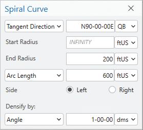
Curves had always been a point of contention. For a while, many GIS folks referred to a variety of geometric elements generically as “arcs,” though not necessarily referring to defined circular arcs (e.g., C3, C5, PC Pt, etc.). “Arcs” were often roughly segmented for display purposes (even CAD does this in its own way). The difference now is that the arc definitions in Esri geodatabases are stored parametrically for circular arcs, elliptical arcs, clothoid spirals, and for Bezier curves. (See graphic.)
Adjustments can be needed for the
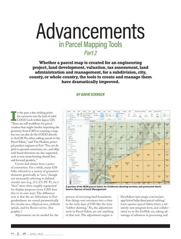
A portion of the BLM parcel fabric for California showing sections and protracted block.
Source: Bureau of Land Management
process of surveying land boundaries. Few things sent surveyors into a tizzy in the early days of GIS like the term “rubber sheeting.” No, the adjustment tools in Parcel Fabric are not anything of that sort. The adjustment engine is
DynAdjust (pro.arcgis.com/en/proapp/latest/help/data/parcel-editing/ least-squares-parcel-fabric.htm), a relatively new program born, and collaborated on in the GitHub era, taking advantage of advances in processing and
computing, e.g., Intel’s Math Kernel Library (MKL). Everyone has their favorite least squares adjustment tool. But with DynAdjust built in, you do not have to go through extra exports and imports.
There is an associated XML format that makes the import of survey data from many platforms easy. DynAdjust might be unfamiliar to many in the surveying community, but it is worth a look; read this
There’s flexibility in what to do with the results of say, a leastsquares adjustment. You might not want to or be authorized to update the parcel. For example, it might represent a tax parcel geometry of record. You can store the adjustment linework as another class. It may inform a future update of other parcel classes or be awaiting QA/QC steps.
Another key improvement is in how controlling points and boundary courses are handled. “You can configure the attributes of points and courses. We have out-of-thebox attributes for what we refer to
as fixed points,” said Hodson. “They can be held in adjustments, and if an editor tries to move it, a constraint prevents this—you get a pop-up error message.” This is what surveyors are used to in their surveying software.
Another key consideration for wide area mapping that surveyors are keenly aware of, is the difference between “grid” and “ground.” Maps are projected to conform to the shape of the particular area of the earth they cover, as closely as possible. However, not close enough to match a distance physically measured on the ground (considering factors including the curvature of the earth), and distances of record. For a recorded survey, the “ground” distances can be labeled. But how can you do this for thousands of parcels?
Hodson’s paper explains: “Mapped lines representing boundaries are stored as line features in the parcel fabric. Using distances as an example, the legally documented value for a specific boundary line is stored as an attribute on the feature. The geometry shape length is also stored as a separate property of the line feature. The shape property is dynamic and is designed to be allowed to change by user workflows; it is system maintained. By comparison, the stored record distance value may only be changed directly by the user and is never automatically changed by the system. It is changed by a user if, for example, a mistake is found, and the value needs to be explicitly updated to match the legal record.”
If you want to add more information and categorize points based on other characteristics, you can do this by adding new attribute fields. For instance, you might wish to assign confidence levels to points from different sources. This can enable different weighting strategies. Linda M. Foster, PLS, GISP, MGIS director, land records/cadastre solutions at Esri said that there is an out-of-the-box schema, but that you can easily extend the schema to include various types of attribute rules and constraints.
A LARGE AGENCY IMPLEMENTATION
The U.S. Bureau of Land Management (BLM) utilizes the Esri ArcGIS Pro Parcel Fabric for the production, maintenance, and dissemination of the Public Land Survey System (PLSS) dataset. The BLM identified this software as being well suited for the diverse requirements of the BLM Cadastral Group. The PLSS dataset serves as the vision for the National Spatial Data Infrastructure (NSDI) and the National Cadastre within the NSDI is to have a single source of authoritative cadastral data that is controlled and managed by designated data stewards.
To effectively manage land data, the BLM required a survey-based land management software that integrates survey records and associates this information with the corresponding geospatial features. Parcel Fabric features an extendable database design, which includes essential point and line attributes that facilitate Coordinate Geometry (COGO) data entry, encompassing bearings, distances, and support for curved line entries. Furthermore, the incorporation of a weighted least-squares engine enables the adjustment of data in accordance with established best practices.
The BLM found Parcel Fabric’s built-in tools valuable for enhancing data quality management. The tools BLM found useful include standard topology rules, data validation layers, and the capability to implement attribution rules. The automation of data integrity maintenance has been a priority for the BLM.
Another recent advancement for the BLM has been the implementation of an ArcGIS Pro Enterprise Deployment. This development allows for a multi-editor solution that enables the simultaneous management of non-PLSS datasets, while ensuring that the geometry of the PLSS is maintained within a single parcel fabric database.
Circular arc and spiral definitions in Parcel Fabric.
“It’s a very flexible model, but starts with a standard foundation,” said Foster. “Once you get to know the schema and system, you can modify and augment—without having to do code-level customization.”
What Foster points out is a key contrast between the tools of yesteryear and today. GIS and geospatial practitioners in the past had to be experts in their respective fields, and a mix of IT specialist, coder, and data scientist. Now, you can be a subject matter expert, without the software being as much of a burden.
WHO’S PARCEL MAPPING?
In North America, as well as in other parts of the world, the driver for map creation is taxation. County tax assessor
maps, even though some are very rough precision-wise, were a foundational element of nearly all early GIS. The same with early road/street features. Often, new layers were built off these early streets and parcel layers, inheriting imprecision. Despite this, the value of these layers has been tremendous. Parcel Fabric can be a tool to update and improve legacy layers.
There is substantial value in parcel maps for spatial analysis, correlation with economic data, developing zoning strategies, insurance rates, public safety, and much more. For state and federal agencies, land management and administration of public lands would be cumbersome to impractical without a parcel base.
There are many countries that have cadastres, one of the earliest was established under Napoleon. They vary, depending on how they serve as a registry of titles and deeds, and in what order of how the act of registration occurs and what happens when there are changes in ownership. That subject would take a multi-volume book series to fully explore, but here are some examples.
countries develop their own cadastres. In some cases, these new cadastres are the mechanism by which land tenures have been formalized and delivered to individuals for the first time.
Nealy every country in the EU has some form of cadastre. They vary in what role each plays as an instrument for land registry and ownership. Sweden, for example, has what many refer to as a coordinate-based cadastre. It is also unique
The Netherlands cadastre is managed by a public agency called “Kadaster” (kadaster.nl/about-us), which manages the land registry and the associate property rights. Kadaster has an international group, which helps developing
in that all property surveys are conducted by the national mapping agency (lantmateriet.se/en/) and/or local municipalities. In some countries, a land surveyor need not be licensed for most types of surveying work, however, to submit or update any survey data for the official cadastre, there are very stringent education, experience, and examination requirements. Foster said that British Columbia, Canada, has a cadastre, though not necessarily
An example of an interactive map portal, My Map, from the national cadastral and mapping agency of Sweden. Source: Lantmäteriet
Tim Hodson, principal product engineer at Esri.
Linda Foster
as the sole instrument of land administration. Similarly, the City of Calgary has a modernized parcel mapping initiative underway. Esri is working with a team in South Australia (where the Torrens Title system had been pioneered in the mid-1800s) on an updated cadastre.
In the U.S., a cadastre as an official instrument for land title, ownership, and conveyances does not exist. However, there are parcel bases for nearly every state, county, and municipality. Except where a state’s laws clearly require that a licensed land surveyor be the creator, or oversee the creation of a parcel base, they can be created and maintained by non-surveyors. However, in many cases, surveyors are tapped for parcel mapping. After all, if you want to create a geology layer, wouldn’t you want a geologist involved?
If I could offer an amalgam of experiences GIS managers have shared on this subject of who should be parcel mapping: “In the early days we got surveyors involved, but they wanted to do a lot of field surveying, and that got too expensive. Plus, they would not compromise on precision. We had to build the parcel map in a hurry with a small budget. Now, we’re getting surveyors involved to improve the parcel layers”.
TRANSFORMING CHALLENGES INTO OPPORTUNITIES
One issue with parcel layers is, no matter how large you put disclaimers, unwitting misuse will occur. I’m sure that many county parcel map managers have had folks call up asking why their hand-held recreational GPS does not line up with the parcel lines on the map (and also cuts through their garage). The imprecise compounded by the imprecise. People are becoming more aware of this, and easily accessible consumer applications, like turn-by-turn navigation, are helping. They learn in real-world situations that both the GPS and the map source have a lot of inherent fuzz.
Foster also noted a county in California that is updating its parcel base, with the full capabilities of Parcel Fabric, and that this is being overseen by licensed surveyors.
“Among the many goals for this modernized parcel theme is digital submission,” said Foster. “For instance, a private surveyor submitting a subdivision plat to the county for review. That’s where things are really moving into the future, with digital delivery.” Another great example of a large parcel base is Harris County Texas (Houston and the surrounding area), and its online parcel viewer: arcweb. hcad.org/parcelviewer.
An updated, precise, and data-rich parcel layer is imperative for any initiative seeking to create digital twin cities. Even if that is not the driver, the era of fuzzy parcel layers (hopefully) will soon be in the past. For whatever reason you may seek to create a parcel map, the resources and tools have never been better. ■
Gavin Schrock is a professional land surveyor who writes on surveying, mapping, GIS, data management, reality capture, satellite navigation, and emerging technologies.
The Surveyor and the “GEODESY CRISIS”
BY TIM BURCH
To the average professional surveyor, the term “geodesy” does not exist in their everyday conversations about the business. While the use of state plane coordinates has expanded greatly with the development of GPS/GNSS receivers and RTK/RTN connectivity, the mathematics and “black magic” of geodesy remains an enigma to most of the profession.
However, the ongoing progression of technology within surveying instruments has expanded the need for understanding how geodesy works. Our practitioners are faced with expanding their knowledge and expertise of geodesy and thus have put a new challenge on them to find teachers and/or mentors to provide training on the datums and techniques.
CRISIS? WHAT CRISIS?
Recently, I was invited to attend a geospatial workforce conference in which various government agencies, university leadership, and members of private industry gathered to discuss the future of geodesy. While the overall theme of the gathering was focused on the future of geospatial datums and how the various parties must work together, a large portion of the conversations highlighted the “geodesy crisis” we are facing throughout the surveying profession. Here are some of the points from the conference to highlight the challenges ahead:
Three levels of geodetic understanding are needed, with different but complementary approaches for each:
• Geodesy experts (geodesists) – While the overall numbers needed may be fewer than expected, we have seen a significant downturn in these experts due to attrition and lack of replacement from higher educational interest. This group includes experts who design, build, and operate our National Spatial Reference Framework (NSRS). It
also includes those who utilize this framework to design and provide the multitude of tools and utilities we use every day (phone and service apps).
• Geodesy knowledgeable (professional surveyors) – This group of geodesy users is responsible for the data being utilized by the profession and follows a normal standard of care for its intended application. Professional surveyors are tasked with assuring clients and the public that the information is correct, so understanding how the tools they use work is a critical requirement. We need additional practitioners who understand the functional use of geodesy in surveying, and we need experts but are having a similar issue with attrition and recruiting.
• Geodesy cognizant (managers & technicians) – This is the area of greatest need. Our profession must have personnel who are technically capable of understanding the basics of geodesy and how it applies to the tasks within surveying. This sector, however, has the lowest cost of investment through education and training, but will continue to struggle with the same workforce recruitment faced throughout the profession.
If these employment challenges were not enough, the geospatial communities also face another potential obstacle: the upcoming modernization of the National
Spatial Reference Framework (NSRS) by our colleagues at the National Geodetic Survey (NGS). Here is a brief explanation from the NGS website regarding why this modernization is a critical upgrade:
The North American Datum of 1983 (NAD 83) and North American Vertical Datum of 1988 (NAVD 88), although still the official horizontal and vertical datums of the NSRS, have been identified as having shortcomings that are best addressed through defining new horizontal and vertical datums. Specifically,
• NAD 83 is misaligned to the earth’s center by about 2.2 meters, and
• NAVD 88 is both biased (by about one-half meter) and tilted (about one meter coast to coast) relative to the best global geoid models available today.
Correcting these two issues will mean that every existing latitude, longitude, ellipsoid height, and orthometric height in the United States (as reported in the current NSRS) will change by as much as four meters (as reported in the modernized NSRS). Adopting the modernized NSRS is critical, as it finally aligns the NSRS with both international standards, as well as aligning with all Global Navigation Satellite Systems (GNSS), which naturally orbit about, and provide positions relative to the center of the Earth.
There is more information about the specifics regarding the modernized NSRS on www.geodesy.noaa.gov.
AS A SURVEYOR/TECHNICIAN/STUDENT, WHAT DOES THIS MEAN TO ME?
While there is an ongoing effort to address the shortage of workers in almost every profession and occupation, the “geodesy crisis,” coupled with the need for modernizing our geodetic reference frames, will take a large, profession-wide effort to tackle these challenges. Here are some of the concepts for addressing these challenges from the geodesy conference and conversations throughout the profession:
Utilize our existing resources
• Invest in our profession through education and training.
• Advocate the geodesy needs to our federal legislators (through private companies and professional organizations).
• Draw attention to upcoming advances in technology and georeference frames
Credit: Dana Caccamise, NGS
that an investment in geodetic infrastructure will bring us back to the forefront of mapping.
Outreach and marketing
• Expand outreach to raise public awareness of geodesy through applicable channels.
• Use examples of everyday technology and location services to highlight the importance of geodesy and its continued educational opportunities to the public.
• Create real-world examples of how geodesy impacts infrastructure, mapping, design, and informational databases of the world around us.
Collaborative efforts
• Partner government agency efforts with professional organizations to demonstrate how public/private data collection and maintenance can benefit our environment.
• Enhance relationships between government agencies, professional societies, and software providers to update critical programming to encourage use of new datums within the NSRS modernization.
Advancing educational opportunities
• Promote expansion of college programs and advanced degrees.
• Create minor degrees in geodesy or geospatial engineering to promote further studies.
• Recruit students from complementary studies, including physics, engineering, and advanced mathematics.
• Create expanded training programs and opportunities.
• Collaboration between agencies and professional societies to create specific training and certifications for geodetic practitioners.
• Encourage more “on-the-job” training opportunities within private and public employers.
THE FUTURE OF SURVEYING IS GEOSPATIALLY DRIVEN
The surveying world is simultaneously growing and shrinking due to the expanding technology and by new advances in geodetic positioning and mapping. Throughout the history of surveying, the practitioner has been tasked with measuring relative distances between fixed works and monuments. With the creation of GPS/GNSS technology (and other remote sensing technics), the surveyor has adapted to this revolution and is now tasked with the collection of locations instead of distances.
Almost all this data collection will benefit from being on a common coordinate system that aligns with the rest of the world. Geodesy is the root of this reference system, so the surveying community must make themselves more in tune with the times.
We are beginning a new chapter of not just our profession, but for mapping our world overall, and surveyors need to be at the heart of this operation. It is our duty to keep reading, learning, and progressing, so don’t close the book and dismiss the surveyor’s role in the future of geodesy. Keep reading and learning, as the road ahead will be worth it. ■
Tim W. Burch is executive director of the National Society of Professional Surveyors.
BY TONY NETTLEMAN
Beyond ON-THE-JOB TRAINING
Throughout the history of land surveying, on-the-job training has been a significant portion of employee development. But is that enough? I agree with the premise that businesses must train their employees, and I encourage anyone reading this to act to ensure the future success of not only their own business but the surveying profession as a whole.
But as they say, “easier said than done.” In furtherance of this goal, let me provide some practical guidance on how to execute such plans based on my own business practices.
THE TEAM MEMBER TRAINING PROGRAM
On-the-job training is not enough. Many surveying businesses claim they train their employees on the job, but I cringe every time that I hear this because then, the trainee is only as good as his mentor. A party chief may be excellent at construction stakeout but lacks a full understanding of boundary retracement. So, is it fair for a newly hired rodman to go through years of fieldwork just to acquire the same skewed professional background as his seasoned party chief? On a more sinister level,
I have myself experienced situations during summer internships where more seasoned field crews do not want to teach the “new guy” everything they know because they fear that the new hire will at some point develop better skills than them and thus become a threat.
Even at higher levels of your survey firm’s “org chart,” the professional surveyor in responsible charge is highly unlikely to have excellent knowledge of every subfield of the profession, not to mention being able to fully teach the LSIT the principles, field work, and processing of new technologies such as UAS, lidar, and bathymetric surveying.
The alternative is a comprehensive employee training system. This system will likely be a mixture of internal and external training systems. The external vendors include Trimble, Carlson, Pix4D, MyCADGirl, NGS, and other vendors. It may be a one-day training course for a new piece of equipment that was just purchased or a onehour webinar hosted by the National Geodetic Survey. I tell my employees, “When a webinar or something interesting piques your interest, sign up immediately.”
Our training program also includes thousands of internal documents we call Unique Methods. These UMs are the internal documentation that explains “how we do it here.” From completing a weekly timesheet or preparing for, flying, and post-processing a lidar dataset, our employees have step-by-step processing for completing the most common tasks.
It may sound expensive to create such systems. But after writing many certificates of merit concerning the sub-standard conduct of survey firms “winging it” at the jobsite, I can assure you that the alternative is much more expensive.
The idea that your business can hire a seasoned survey technician, surveyor-in-training, or professional surveyor, whenever the business needs the capacity to serve more clients is a fiction. Even the engineering firms that pay top dollar find it impossible to hire talented surveyors in today’s employment market.
So, what is the alternative? The only
choice that my firm has found is to hire for attitude and train for aptitude. In such a tight job market as it exists today and will likely exist for years or decades to come, the health and success of your business depends on an employee development process that works collaboratively with each team member to continually grow their skills, talents, and certifications.
At my firm, the premise is simple: grow or go. Either the team member will actively work with management to grow, both personally and professionally, or they must leave. This philosophy encourages team members to plan their own development goals, choose their own courses, books, classes, etc., and then use those opportunities to help our business grow.
Some team members have no desire to engage in such endeavors. For example, one team member wanted to use her personal development funds to purchase candle making materials. That attitude was the canary in the coalmine for us. It was time for her to go somewhere else. We have found this process to be an excellent bellweather concerning whether certain team members should continue to be employed by our firm. Each team member in your firm should have a personal development plan that outlines how they are going to grow in the next 12 months. That plan should be reviewed at least monthly to determine if that individual is on-track to meet their goals. Our team members will have all of those development courses paid for, but they must donate the time to complete the courses.
THE TEAM MEMBER INCENTIVE PROGRAM
If you have been lucky enough to have team members who appreciate the value of personal development, it’s not over yet. It is incumbent upon your firm to support and nurture your team members. This may be done in a variety of ways, such as financial support for classes, financial benefits to team members upon achieving certain goals, and most importantly of all, giving the team members paid time to complete such activities.
First, my firm provides a minimum of $500 per year for every team
member for any type of development that may also benefit our firm. The team member may spend the money in the pursuit of any legitimate professional development activity. If the team member can justify a larger expense, it is almost always approved. Why put a limit on ambition?
Second, we provide a $1,000 bonus for full-time employees and a $500 bonus for part-time employees upon passing the FS, PS, or becoming licensed in a new state. It takes me days and days of studying to gain another professional license, so I feel that it is only fair that our team members are rewarded for all of their hard work studying for and passing an exam. As an additional benefit to the firm, we may write a short book about how to get licensed in a particular state.
Third, we provide as much mentoring time to the team member as possible. Technicians are often invited to state society surveying conferences. I meet with the technicians at least twice a month to discuss their personal lives, ambitions, and how I can help them succeed in their careers, and my door is always open.
The implicit employer-employee agreement that a team member will get paid a decent wage for a hard day’s work is over. Employees expect to be engaged, happy, and well-compensated and, in my opinion, that is only fair. The competition to hire quality technicians and professionals will only increase in the coming years. The firms that have the best training, mentoring, and development processes will continue to thrive while the firms that only see the bottom-dollar profits will continue to shrink.
In 2025 and beyond, what choice will you make on behalf of your firm? ■
Dr. Tony Nettleman is director of Nettleman Institute of Surveying Engineering (NISET). He holds a law degree and three degrees in land surveying. He has been practicing for more than 20 years and still enjoys just about every day of it. He has held professorships at Texas A&M Corpus Christi, University of Florida, and Florida Atlantic.
CLASSIFIED ADVERTISING
Instrument Repair
Instrument Repair Equipment
Contact Angie Duman to place your listing here! angie.duman@xyht.com
Seiler Instrument Geospatial Offices in IL, IN, KS, KY, MI, MO, NE, WI 877-330-6303
There are many players in a boundary dispute case, the judge, perhaps a jury, the parties, the attorneys, and maybe some witnesses. When a surveyor is hired as an expert in such a case, it is not the surveyor’s responsibility to win a boundary dispute case, but the surveyor can play a significant part towards that end.
Even if not hired as an expert, a surveyor could also be called upon to defend a boundary determination previously made. Therefore, it is incumbent upon the practitioner to make every boundary determination as if going to court and defending that decision. With this assumption in mind, let’s look at a few things the prudent practitioner might want to consider.
To begin with, you need to assume there will be a competing survey performed by a competing surveyor if you go to court. This means that one surveyor is going to be a winner and the other will be a loser. If it’s not already obvious, you want to be the winner. Losing the case can have other negative repercussions.
If you are the only surveyor in court this is not necessarily a positive sign. It could mean one of two things: the other side can’t afford a surveyor or they think your survey is so bad they don’t need a surveyor. There are many example cases where there was only one surveyor in court and the client still lost the case–the primary reason being the surveyor didn’t make a boundary determination that could win in court.
You need to keep the ultimate objective in mind when you prepare any survey of property. It needs to be almost self-explanatory. This is a big job because few people
outside of the surveying community can read a map of survey let alone understand the results, and your survey could end up in court before you or without you. Keep things as simple as possible. Use appropriate notes, accentuate the important, explain the results, and make sure your survey passes the commonsense test. For example, are you attempting to move that which should not be moved? That will not pass the commonsense test.
Once in court, the ultimate objective will be to lead the judge out of the case. Trust me, when it comes to boundary disputes and surveyors, judges want out. This objective is as applicable whether you are in court voluntarily or if you are there involuntarily. If you didn’t expect to be in court, then you were summoned because your survey is already part of the litigation and, at that point, your survey is what it is. If your survey is self-explanatory with well-reasoned results, it will come to your aid and not to your detriment. In any event, once in court you and your survey will need to make common sense out of what is often nonsensical.
You need to understand that any boundary dispute case can be solved by a judge with a plaintiff and a defendant. In a boundary dispute case, no attorneys are required, and surveyors are not a necessity. Now, most people wouldn’t go to court without an attorney and in a boundary dispute many feel they need a surveyor. Good for them. But neither is required which tells us volumes about resolving boundary disputes.
In a pure boundary dispute case, there are no legal arguments and measurements are not necessary for a resolution. An
adverse possession case on the other hand is a title fight, but a pure boundary disputes case is a factual question of location. So, the ultimate test of your property boundary determination is: Did you correctly answer the factual question of location? That’s the only question.
Too often the surveyor in court can’t supply the way out for the judge because they can’t see the forest for the trees—trees being a metaphor for the measurements. The parties don’t have that disability and can focus on the issues that matter. This is why surveyors aren’t needed in a boundary dispute case and are often counterproductive when they are.
Surveyors try to explain the “what” and the “how” of the survey, and in the process tend to lose credibility with the court. When you lose credibility, the case is over. It is much more important to explain “why” the resulting boundary determination was made. Next time around we will look at addressing the “why” issue.
The purpose of this column is to encourage your questions on legal issues that affect the surveying profession. You are invited to send your questions to the editor of xyHt. ■
Jeff Lucas is an attorney and land surveyor in private practice in Birmingham, AL. Jeff is an author, columnist, lecturer, seminar presenter, and continuing education provider. He writes a monthly newsletter, The Lucas Letter, dealing with legal issues and the practice of surveying. More information about Jeff and his continuing education courses can be found at www.lucasandcompany.com