PUEBLONUEVO
Urban Centers of Caral Civilization: 21 years recovering history on the Social System


ALLPACOTO

PIEDRAPARADA
ELMOLINO

CHUPACIGARRO

MIRAYA
 Ruth Shady
Carlos Leyva
Ruth Shady
Carlos Leyva
CREDITS
Production And Edition: Ruth Shady, Marco Machacuay, Pedro Novoa, Edna Quispe and Carlos Leyva
tEAm of ArchAEologists of ZAc: Marco Bezares, Plinio Guillén, David Palomino, Gustavo Espinoza, Franco Valdez, Héctor Cárdenas and Luis Miranda
PrEsErvAtion AsPEcts: Víctor Pimentel and Carmen Salas
gEomAtics: Luis Salcedo
mAtEriAl AnAlysis: Sonia López and Carlos Viviano
dEsign And lAyout: Marco Chacón
3d rEconstructions: Estela Vásquez
PhotogrAPhs:
Team of the Zona Arqueológica Caral, Marco Chacón, Christopher Kleihege and Walter Wust
illustrAtEd PublicAtion:
Urban Centers of Caral Civilization: 21 years recovering history on the Social System. 1st edition 2017
trAslAtion: ESIT Traducciones
© Zona Arqueológica Caral, UE 003 – Ministry of Culture
Av. Las Lomas de La Molina N0 327, Lima 12, Peru. Phone number: 205-2500 www.zonacaral.gob.pe
Legal deposit done at the National Library of Peru, Nº 2017-17694
ISBN: 978-612-47113-4-3
Copyrights: total or partial reproduction of this publication by any means is forbidden.
Printing was completed in the graphical workshops of Burcon Impresores y Derivado SAC
Address: Jirón Francisco Lazo Nº 1924, Lince, Lima
December 2017
Lima, Peru
Print run: 1000 issues
2 | CARAL 21 YEARS
Urban Centers of Caral Civilization: 21 years recovering history on the Social System
Ruth Shady
Marco Machacuay
Pedro Novoa
Edna Quispe

Carlos Leyva
4 | CARAL 21 YEARS
Introduction: Zona Arqueológica Caral [ 6 ] CHAPTER 1 [ 8 ] Research in the Supe valley, Investigations in the Caral archaeological area [ 8 ] CHAPTER 2 [14] Settlements in the Supe valley: upper, medium and lower sections and coastline [14] CHAPTER 3 [18] Intervened archaeological sites [18] 3.1 Medium lower section of the Supe valley: [19] 3.1.1 Left bank [20] A. Sacred city of Caral [20] - Residential sub-complex A5 [30] - Major Public Pyramidal Building C1 [34] - Minor Public Pyramidal Building C4 [38] - Residential sub-complex C5 [40] - Residential sub-complex D1 [42] - Major Public Pyramidal Building with sunken circular plaza E1 [44] - Minor Public Building E2-E3 [48] - Circular Altar of the Minor Public Building E2-E3 [52] B. Chupacigarro urban center [58] - Sub-complex of buildings A [64] - Sub-complex of buildings B [68] - Sub-complex of buildings C [72] - Sub-complex of buildings D [76] - Public building F16 [77] C. Miraya urban center [80] - Residential sub-complex C1 [88] - Minor Public Pyramidal Building C3 [90] - Major Public Pyramidal Building C4 [92] - Minor Public Pyramidal Building C5 “Las Esculturas building” [96] - Major Public Pyramidal Building with sunken circular plaza A1 [100] - Minor Public Pyramidal Building F1 [104] - Minor Public Pyramidal Building with sunken circular plaza inserted in a quadrangular platform B1 [108] - Minor Public Building A4 [112] D. Lurihuasi urban center [122] - Major Public Pyramidal Building H1 [130] - Minor Public Building of extended architecture G1 [132] - Public pyramidal Building E2 [134] - Residential Unit B [136] - Minor Public Pyramidal Building F1 [138] - Unidad Residencial B [140] - Major Public Pyramidal Building D3 [142] - Residential Unit A1 [144] - Public pyramidal Buidling A3 [146] - Minor Public Building M [147] 3.1.2 Right bank [152] A. Allpacoto urban center [152] - Public Building with sunken circular plaza A [156] - Minor Public Building E1 [158]
CONTENTS
- Public Pyramidal Building A1 [246]
- Built space F1 [246]
- Built space F4 [248]
CHAPTER 4 [251]
Preservation and Restoration of the Immovable Cultural Heritage of Caral Civilization [251]
CHAPTER 5 [255] Multidisciplinary approach [255]
5.1 Archaeological material analysis [255]
5.2 Geomatics applied to Archaeology [257]
CHAPTER 6 [262] Dissemination of the social history of Caral, Cultural Heritage Projection [262]
6.1 Tour to the archaeological site of the Sacred City of Caral [264]
6.2 Visitor Reception Center of Caral of Caral [266]
6.2.1 Implementation of the “Science tunnel”: Caral, 5000 years producing scientific and technological knowledge [267]
6.2.2 Construction of modules to showcase the social responsibility programs of ZAC [268]
6.3 Community museum of Supe [270]
CHAPTER 7 [271]
Caral civilization: Actions connecting the present to the past [271]
CHAPTER 8 [281]
Reference bibliography [281]
CARAL 21 YEARS | 5 - Residential sub-complex B1 [162] - Major Public Pyramidal Building C1 [164] - Minor Public Building C4 [168] - Minor Public Building C7 [170] - Minor Public Building D2 [174] - Minor Public Pyramidal Building E2 [176] - Minor Public Building G [178] B. Pueblo Nuevo urban center [182] - Major Public Pyramidal Building with Sunken circular plaza F [188] - Major Public Pyramidal Building with Sunken circular plaza H [192] - Public Pyramidal Building A1 [196] - Residence A3 [197] 3.2 Lower section of the Supe valley [200] 3.2.1. Left bank [200] Piedra Parada urban center [200] - Major Public Building with sunken circular plaza A1 [204] - Minor Public Building A2 [206] - Minor Public Building A5 [208] - Major Public Pyramidal Building B1 [210] - Minor Public Building B3 [212] - Minor Public Building G [214] - RResidential compounds F1 [216] 3.2.2. Right bank [222] A. El Molino urban center [222] - Major Public Pyramidal Building A [226] - Minor Public Pyramidal Building C [228] B. Era de Pando urban center [232] - Major Public Pyramidal Building with sunken circular plaza C1 [238] -
Residential Unit C10 [242]
- Minor Public Building C12 [243]
- Minor Public Pyramidal Building B1 [244]
ZONA ARQUEOLÓGICA CARAL INTRODUCTION (CARAL ARCHAELOGICAL ZONE)
Zona Arqueológica Caral (ZAC) is a public institution, which works under scientific, administrative and financial management autonomy. It was created by Supreme Decree 003-2003-ED, dated February 14, 2003, ratified by Law 28690, dated March 18, 2006, and attached to the Ministry of Culture -as Executive Unit- since July 2010.
ZAC is responsible for conducting investigation and preservation activities, and for disseminating the social and cultural values of the Caral civilization, the oldest in America, nation and worldwide; as well as for protecting this civilization’s valuable archaeological heritage and its cultural landscape for the benefit of current and future populations.
Its goal is turning Caral civilization into the most outstanding archaeological resource of the Peruvian north central area, and specifically of the Supe basin, as the cornerstone promoting comprehensive and sustainable development for its populations.
ZAC’s general goals are the following:
• Recovering social history through archaeological research;
• Preserving archaeological heritage and spreading its values for the benefit of current and future societies;
• Disseminating the history of Caral civilization;
• Strengthening cultural identity and improving social self-esteem through the
recovered historical knowledge and intangible culture;
• Preserving the environment and natural resources;
• Promoting the implementation of the Master Plan for Supe and its area of influence to contribute to cultural, social and economic development of the local and regional population, by providing value to the Caral civilization settlements, promoting organic farming, producing diverse goods with cultural identity and providing touristic services.
With this perspective, ZAC conducts research on the Sacred City of Caral and other eleven settlements, related to Caral civilization: Chupacigarro, Miraya, Lurihuasi, Allpacoto, Pueblo Nuevo, Era de Pando, El Molino, Piedra Parada, Peñico, Áspero and Vichama, to compare data and draw conclusions supporting interpretations on the origins of this civilization, to get to know the changes that occurred over the thousand years it held its prestige during the Initial Formative period, and the reasons why it lost such prestige.
By identifying new urban centers in the Supe valley, which correspond to the Early Formative period, ZAC is studying the relationship of Caral civilization with other Andean societies, the impact it had on them and the external effects produced by the Caral crisis.
Furthermore, ZAC is responsibly assuming the preservation of archaeological settle-
6 | CARAL 21 YEARS
ments, promoting the training of a group of people, and it is continuously monitoring the preservation efforts, taking into account authenticity and integrity principles set forth in international documents on monument preservation.
It is worth mentioning that the settlements intervened by ZAC have been selected since they are being affected by several interests, mostly private ones.
Since the beginning of its activities, ZAC has deployed a permanent work to achieve legal physical clearance of archaeological sites in the Supe valley, defend its integrity and ensure its preservation.
ZAC prepares and edits scientific publications, as well as papers and bulletins; it programs tours to the archaeological sites; organizes events and museum exhibits to disseminate historical and cultural values of Caral civilization; conducts natural and cultural heritage preservation activities; organizes workshops to enhancement tangible and intangible culture, as well as training workshops (on organic farming, natural color cotton, music, among others) and it fosters the population’s comprehensive socio-economic development, to contribute to improving life conditions in the Peruvian north-central area.

CARAL 21 YEARS | 7
Minor Pyramidal building and La Galería (The Galery) Pyramidal building, of the Sacred City of Caral.
Panoramic view of the Central building of the Sacred City of Caral. All monumental buildings in the Sacred City of Caral were found in such conditions, as natural mounds.
IN THE VALLEY SUPE RESEARCH
INVESTIGATIONS IN THE CARAL ARCHAEOLOGICAL AREA


In 1994, Dr. Ruth Shady and a group of archaeologists initiated investigations with archaeological explorations in the Supe valley, and two years after in Caral.
As a result, they identified a series of archaeological settlements that corresponded to the then called Late Archaic period, currently known as Initial Formative period (3000 – 1800 B.C.). In their publication they included the characterization of the sites’ architecture, as well as their similarities and differences, preliminary interpretations on the settlement patterns and inferences on the social system that produced them (Shady et al. 2000).
At the beginning of the investigation in the sacred city of Caral they had the support of the distinguished researcher Betty Meggers,
8 | CARAL 21 YEARS CHAPTER 1
Sunken circular plaza, of the Main Pyramidal Building of the Sacred City of Caral.
which led to the economic support of the National Geographic Society.
Moreover, they had the logistic support of the then National Institute of Culture (currently the Ministry of Culture). Archaeological research works continued with the support of the National University of San Marcos. After two months digging in six sectors of the sacred city of Caral, enough tangible evidence was obtained to conclude that it was a built settlement, which was operating before pottery was introduced in the Central Andes, with great architectural complexity and, thus, also social complexity, which had a fundamental role in the origin of the civilization, during the Initial Formative period (Shady 1997a, b).
Considering the research results obtained, in 1997 authorities of the National University of San Marcos assigned the Caral Archaeological Project to the University’s Museum of Archaeology and Anthropology, providing institutional support to research, preservation and dissemination activities.

Later, archaeological research was extended to other sites in Chupacigarro in 1999 and Miraya in 2001.
In 2001, the then Minister of Education, Dr. Marcial Rubio visited the Sacred City of Caral, encouraged by his wife, the archaeologist Margarita Giesecke. Shortly after, the President of the Republic, Dr. Valentín Paniagua and all his ministers arrived into -and met- the Sacred City. By recognizing the significance of the results obtained by the archaeological project, and the great potential of this ancient city, the government of Peru declared the investigation, registration, enhancement and preservation of the
Sacred City of Caral -the main settlement of the Caral civilization- is of national interest, by Supreme Decree 040-2001-ED. This statement enabled the government to allocate an annual budget to the Caral-Supe Archaeological Project, through the budget of the National University of San Marcos, for

CARAL 21 YEARS | 9
Official visit of the President, Dr. Valentín Paniagua, the Ambassador Mr. Javier Pérez de Cuéllar and other ministers to the Sacred City of Caral, 2001.
Aerial view of the Major Public Building, of extended architecture with sunken circular plaza, of the Sacred City of Caral.
the development of the activities declared to be of national interest.
In 2003, the Special Caral-Supe Archaeological Project was created with the Supreme Decree 003-2003-ED, which became law in 2006 (Law 28690), with full scientific, administrative and financial management autonomy. It was assigned to the National Institute of Culture (currently, Ministry of Culture), where the Executive Unit 003: Zona Arqueológica Caral (ZAC) was created to channel ZAC’s budget and ensure its autonomous implementation.

The creation of the ZAC enabled extending the activities to promote other archaeological sites of the Supe valley that were in danger of disappearing, and applying a comprehensive approach considering the social and economic development of the local population.
In 2004 the ZAC promoted the preparation of the Master Plan for the development of Caral and its area of influence ; it was done through participative workshops with the local population, politicians and academics. The Master Plan aims at articulating the archaeological heritage of Caral civilization with social and economic activities performed by the local population, so that these archaeological sites, after being enhanced, become the cornerstone promoting comprehensive development in the north-central area of the country. Such responsibility shall be assumed within a context of preservation of the natural and cultural landscape and revaluation of intangible culture. The Master Plan, which first stage is fifteen years long, was approved in 2005, and its implementation was commissioned to Zona Arqueológica Caral (ZAC) by Law 28690 in 2006.
The Major Public Pyramidal Building with sunken circular plaza, Sacred City of Caral.
In coordination with the District Municipality of Supe Port, the recovery of the monumental archaeological site of Áspero, a fishing town of the Caral civilization -which had been being used as a dumpster by two municipalities for almost thirty years- started in 2005.


That same year, ZAC started investigations in the monumental site of Allpacoto, located in the right bank of the Supe River, in front of the sacred city of Caral.

Upon the request of ZAC, the UNESCO World Heritage Center assessed the exceptional universal values of the Sacred City of Caral, and in 2009 it declared it a World Heritage Site. This distinction has been a contribution to the world recognition of the Peruvian culture, and a direct benefit for Supe district, Barranca province, Lima region and the country.
Two years later, through a strategic partnership between ZAC and the District Municipality of Végueta, we started recovering and enhancing Vichama, agro-fishing town of Végueta, in Huaura valley.
In 2010 ZAC received significant economic support for preservation activities in the Sacred City of Caral, since it was awarded with the US Ambassador Fund for Cultural Preservation.
This year, also, the budget allocated to ZAC by the Peruvian government was transferred from the investment expenditure item to the current expenditure item, thus recognizing the permanent nature of the activities carried out to enhance Caral civilization’s sites. When the Ministry of Culture was created, ZAC remained assigned to this new institution, as Executive Unit 003, with the permanence and autonomy granted by Law 28690 of 2006.
CARAL 21 YEARS | 11
The UNESCO World Heritage Center declared the Sacred City of Caral as World Heritage. June 2009.
Former mayor of Végueta, Mr. José Li, the former Vice-Minister of Tourism, Mr. Eduardo Arrarte, the Head of ZAC, Dr. Ruth Shady, and Mr. Aldemar Crispín and other stakeholders observe the findings of the first excavations in Vichama. August 2007.
“Los Ídolos” (The Idols) building, monumental archaeological site of Áspero, Fishing city of Caral civilization. September 2015.
In 2010, the recovery of the Era de Pando settlement started, which then had serious land invasion problems and its archaeological components were being affected. The value enhancement activities were accompanied by legal actions, which ended in the recovery of this significant site of the country’s cultural heritage and its return to the Peruvian government, in 2011. From that date on, social and economic development efforts are being conducted by the strategic partnership between ZAC and San Fernando SA, with the Supe valley residents.
Other archaeological sites of the Caral civilization, which integrity was being affected, and which have been included in ZAC’s value enhancement tasks, through the dialogue and coordination with the representatives of the Supe valley’s populated centers, which are El Molino and Pueblo Nuevo, since 2011, and Piedra Parada, since 2012.
In all archaeological sites intervened by ZAC, investigation works are conducted to recover the social history, of preservation to ensure its permanence and enjoyment by the current and future population, and of dissemination to spread the knowledge
to all Peruvians so that it is incorporated in the social dynamics. ZAC conducts these tasks with working teams comprised by professionals, technicians and assistants, in which mainly the trained local population participates. The training is permanently updated, on excavation and registration, preservation and restoration, analysis and identification of archaeological materials, and guidance to visitors.
To strengthen its research activities and management of archaeological heritage, using the autonomy provided by the Law, ZAC has entered into cooperation agreements with several institutions, such as the National Geographic Institute (IGN), the National Engineering University (UNI), the National Institute for Telecommunication Research and Training (INICTEL), the National Geophysics Institute of Peru (IGP), the National Institute of Geology, Mining and Metallurgy (INGEMMET), the Marine Institute of Peru (IMARPE), the National Service of Meteorology and Hydrology (SENAMHI), the Peruvian Institute of Nuclear Energy (IPEN) and the National University of San Marcos (UNMSM), among others. Based on this multi-disciplinary work, we have reached a larger prog-
ress in the research on the Caral’s social system and a better understanding of this civilization.
Through the years, with the development of investigations in several sites of the Caral civilization, located in the Supe and Huaura valleys, we achieved a better ap-

12 | CARAL 21 YEARS
proach to the knowledge of this civilization’s origins and changes. We know the Caral civilization continued during the Initial Formative period up to the moment when a strong climate change occurred with catastrophic effects on the valley’s agricultural production and on marine productivity. There
were strong changes in the societies of the area, which affected the wide occupations of the Initial Formative period in the Sacred City of Caral, and in other settlements. Other minor changes took place, which Early Formative period components have been identified in places such as Miraya, Era de Pan-

do, Lurihuasi, Piedra Parada, Allpacoto and Vichama. Notwithstanding, social, cultural, architectonic and stylistic influences of the Caral civilization are strongly identified up to the Intermediate Formative period, and certain elements with symbolic meaning remained throughout the Andean cultural process.
CARAL 21 YEARS | 13
Panoramic view of the Sacred City of Caral and its natural environment.
SUPE SETTLEMENTS OF THE VALLEY
UPPER, MEDIUM AND LOWER SECTIONS AND COASTLINE

On the Coastline
ÁSPERO


The Áspero archaeological complex is 500 meters away from the Pacific Ocean, at the right bank of the Supe River, in a natural environment comprised by hills, terraces, dunes, wetlands, farmland and beaches. It occupies 18.75 hectares.


A differentiated social structure and specialized activities of Áspero population may be inferred from the materials recovered in 22 sectors of the city. There are seven stepped pyramidal buildings, which would have been conducted by the leading class, and used for social, administrative and worship activities. Huaca Alta, Huaca de los Ídolos and Huaca de los Sacrificios stand out. In the city, elite residential buildings were also identified, as well as other smaller ones. Áspero supplied significant sea resources to the population of Caral civilization during the Initial Formative period, and to the residents of the valley after the economic crisis, during the Early Formative period.
In the lower Section
Right bank:
EL MOLINO
Settlement of the Early Formative period, formed by minor public buildings. Its architectural designs, style and building techniques are similar to those of contemporary settlements, such as Vichama in the Huaura valley and Piedra Parada in the Supe valley.
The urban design of the El Molino archaeological site has been affected by facilities built in the hacienda period, which continued to be used by the Agrarian Cooperative, and by the modern houses built in the current urban center of that name. There are only a few archaeological buildings between houses and fields.
14 | CARAL 21 YEARS CHAPTER 2
Settlements of the Supe valley.
Áspero archaeological site.
Coastline
Left bank
Right bank
ERA DE PANDO
The archaeological site occupies the gully called Era de Pando, 13 km away from the coastline. The gully is formed by three geological terraces of colluvial formation, in the middle of a wide plain with runoffs from the Taro and Orqueta mountains. It is a natural way to connect with the Pativilca valley and the Tayta Laynes micro-basin.
The architectural components of the archaeological site, of 57.93 hectares, were built on the terraces and the neighboring hills’ slopes.


Two periods of occupation have been identified. The larger expansion of built space occurred during the Initial Formative period, with large public stepped pyramidal buildings, sunken circular plazas inside quadrangular platforms, minor public buildings, over the former ones, located in a peripheral area.
This settlement was being affected by a concession granted without assessing its cultural heritage condition. After a process for protecting and defending it, this property was recovered for the nation and it was registered as State property.

Left bank:
PIEDRA PARADA
The Piedra Parada urban center, of 37.54 hectares, was built on low rocky promontories of the Andes range, covered by dunes, known as Tutumo. That place has access to the river, to the riverside forest, to wetlands with totora and reed, to sandy soils, farmland and the beach -2.63 kilometer away- and its fish and shellfish resources.
Piedra Parada is formed by public buildings of extended architecture and residential compounds with Early Formative period features. At that time, it was the main urban center of the Supe valley’s low section.
The relocation of the farmers that have been located in the nuclear area of the old settlement is in process.
CARAL 21 YEARS | 15
El Molino archaeological site.
Monument with sunken circular plaza of the Era de Pando archaeological site.
Piedra Parada archaeological site.
At the medium lower section
Capital area
It is a section of the medium low valley, 10 km long, where eight urban centers of Caral civilization have been identified: four in the right bank of the Super River: Pueblo Nuevo, Cerro Colorado, Allpacoto and Llaqta, and four in the left bank: Sacred city of Caral, Chupacigarro, Miraya and Lurihuasi. This spatial distribution is related to the dual pattern of organization that has characterized Andean societies. All settlements were built on dry lands, above the productive lands of the valley and the Super River.

Right Bank:
PUEBLO NUEVO
Left bank:
LURIHUASI
It is located at a dry gully, of alluvial soil and with steep slope. It covers 38,11 hectares and it is comprised by public pyramidal buildings of different sizes and architectural designs. A road from Lurihuasi connected the people of that part of the valley with the lower section of the Huaura valley.
MIRAYA
It is 1,5 kilometers west from Chupacigarro and 2,2 kilometers away from the sacred city of Caral. It covers 33,90 hectares. The largest cultural component dates back to the Initial Formative period; the one corresponding to the Early Formative period is reduced. Public pyramidal buildings stand out in the settlement; some of them have a sunken circular plaza, as well as residential areas from both periods.

16 | CARAL 21 YEARS
Located in front of the Lurihuasi settlement, on a high terrace, formed by alluvial deposits from surrounding hills and gullies. In its 23.49 hectares, public stepped pyramidal buildings with sunken circular plazas stand out as well as a building, which architecture has been adapted to a hill to make it visible from the valley.
Panoramic view of the Capital area, in the medium low area of the Supe valley.
CERRO COLORADO
Settlement preserved in 22.75 hectares, located on specially adapted hills and geological terraces. Two pyramidal buildings stand out, one of which is led by a sunken circular plaza. It is strategically located in the control area of an inter-basin road. Areas with residential buildings have also been identified.
ALLPACOTO
It occupies 18.57 hectares of the Allpacoto valley. Its architectural components correspond to the Initial Formative, Early Formative and Intermediate Formative periods, and are testimony of the long occupation of the area, of its contribution to the formation of Caral civilization and its changes over time. The urban and building design, and the building technologies are different in each Formative period. Public pyramidal buildings of extended architecture stand out, some of them with sunken circular plazas, as well as residences. The site has been affected by farming activities and extraction of building materials.
LLAQTA
It is located northeast from the current population center of Caral, covering 12,03 hectares. The buildings comprising it, still not excavated, are grouped around a rocky promontory of Cerro Las Minas. In the site, walls of stone terraces were used to adapt the natural relief to build minor public buildings and, possibly, residential units.
SACRED CITY OF CARAL

Settlement located 26 km away from the coastline, with a 68-hectare area. It comprises a core area with 32 public buildings and several residential compounds, and two peripheral outlying areas, one of which borders the valley, where several housing sub-complexes and a minor public building were built.
In the central space of the sacred city of Caral there are larger public and residential buildings, distributed in two big halves: the upper half, in the northern side, and the lower half, in the south.
During Caral civilization’s existence, the most prestigious and significant activities were conducted in this capital city: coordination with political authorities of other urban centers; religious ceremonies; economic and social events, fairs and periodical buildings, and architectural refurbishments.
CHUPACIGARRO
It is one kilometer west of the sacred city of Caral. It covers 38.59 hectares and is comprised by public buildings, distributed on geological terraces, around a large central space, and by sub-complexes of residential units in the periphery. A public building of extended architecture with a sunken circular plaza and stairs located over the same axis, with large monoliths on the sides, stand out in the southern area of the central space. It is possible that almost half the archaeological settlement has been destroyed.
CARAL 21 YEARS | 17
INTERVENED SITES ARCHAEOLOGICAL
From 1994 to 1995, Ruth Shady led an investigation in the Supe valley, from the coastline to Ámbar. With her investigation team they recognized tens of archaeological sites, segregating eighteen settlements with monumental architecture because of their characteristics, which were identified as the earlier ones. To solve the question on the settlement temporality, Shady started excavations in the Sacred City of Caral in 1996, which allowed determining –in 1997- that it belongs to the Initial Formative period (formerly known as Late Archaic period) and its value as a testimony of the first Andean civilization: Caral, which is 5000 years old. Since then, investigations have continued without interruptions and the number of settlements related to the Initial Formative period in the Supe valley have increased to 25, ten of which are being excavated to better know Caral civilization’s social system.
Additional archaeological interventions to those conducted in the Sacred City of Caral, took place in Chupacigarro since 1999, in Miraya and Lurihuasi since 2002, in Áspero since 2005, Allpacoto and Era de Pando since 2009, Pueblo Nuevo and Piedra Parada since 2012 and El Molino since 2013. In Vichama,

located in the Huaura valley, investigations started in 2007.
Results of the investigations conducted in the Sacred City of Caral have been published in several volumes, as interventions are moving forward. The most recent one is: “Caral. 20 años recuperando la historia de la Civilización Caral para el Perú y el mundo, con responsabilidad social” (Caral. 20 years recovering the history of Caral civilization for Peru and the world, with social responsibility) (October 2014). The social history of Áspero archaeological complex, intervened since 2005, may be reviewed in the publication: “Áspero, Ciudad pesquera de la Civilización Caral, 5000 años de ciencia y tecnología pesquera.

10 años recuperando su historia social” (Áspero, fishing city of Caral civilization, 5000 years of science and fishing technology. 10 years recovering its social history) (March, 2015). And information on Vichama may be found in: “Vichama. Historia Social de la Civilización en Végueta. 3800 años de memoria colectiva de nuestros ancestros de Vichama ante el cambio climático” (Vichama. Social history of civilization in Végueta. 3800 years of collective memory of our Vichama ancestors to address climate change) (June, 2015).
Publication on Caral, 2014.
Publication on Áspero, 2015.
Publication on Vichama, 2015.

18 | CARAL 21 YEARS
CHAPTER 3
MEDIUM LOWER SUPE
SECTION OF THE VALLEY

3.1
La Galería (The Gallery) public pyramidal building of the sacred city of Caral, in the medium lower section, left bank of Supe valley.
SACRED CITY OF CARAL A


3.1.1
La Huanca (Standing stone) sector, in the upper half of the sacred city of Caral: Minor Public Pyramidal Building, La Galería pyramidal building, La Huanca public pyramidal building and La Huanca square.
Left bank
Location
Caral archaeological settlement can be accessed taking the exit at Km 184 of the North Pan-American highway, and then continuing for 30 kilometers towards Ámbar.


CARAL URBAN CENTER LOCATION MAP
Polygonal
Occupation site
Population center
Unpaved road
Supe River
Political location:
Department: Lima
Province: Barranca
District: Supe
Geographical location:
Zone: 18S
Reference system: WGS84
UTM coodinates:
224 275.01 E / 8 794 632.16 N
Average altitude: 350 m a. s. l.
Urban center area: 68 ha
Geographical aspects
The Caral urban center was built in the left bank of the Supe River, in the medium lower section of the valley, in the so-called Capital Area of Caral Civilization (Shady 2008: 69). It was built on high wide terraces of fluvial, alluvial and colluvial origin, surrounded by the Gozne Mountain in the East, Miraya in the West and Mulato in the South.
From the city you may see the whole middle valley, urban centers of the capital area and
the farmlands; and vice versa. In the agricultural fields, located in front of the city, in a 15.72 hectare area they grew squash, beans, lima beans, pumpkin, cotton, sweet potato, chili pepper, mate, achira (arrowroot) and tutumo, among others. Near the sacred city of Caral two springs (puquiales) have been identified, located 35 and 150 meters away, which provided drinking water to the city residents. They caught fish and shrimps in the river. In the surrounding hills they collected wild resources,
CARAL 21 YEARS | 21
CARAL
Caral urban center.
such as fruits, roots and snails; furthermore, they hunted deer and vizcacha. The wide shell middens, formed in several periods, are evidence of the temporary occupation of the hills. In the wetlands and swamps they cut reed and totora and process them to make “shicras” –vegetable fiber bags–, mats and baskets, among others. From the riverside forest they obtained caña brava (giant reed) for quincha constructions and timber trees, such as willows and pájaro bobo (Tessaria inte grifolia). On the alluvial terraces the huarango prevailed. Vegetable material used for the city buildings and houses.
The blocks of rock, used for the buildings and residential compounds, were extracted from quarries located in the nearby Mulato and Gozne mountains, as well as from a rocky outcrop located inside the city. Rocks were also selected to make axes, boleadoras

and arrowheads. They built and enhanced the buildings by using structured deposits of “shicras”, which they filled with pebbles, cut stones and dirt. This building technique provided seismic resistance to the buildings (Shady 2014: 62-63).
Background
The Caral archaeological site was declared National Cultural Heritage with the National Director’s Resolution Nº 720/INC, dated August 01, 2002.
In the 40s, the investigator Paul Kosok conducted a significant study on several valleys of the central coast, which included a visit to the Supe valley, where he described some aspects of the Caral archaeological site, then known as Chupacigarro. In his publication (Kosok 1965: 219) he presented an aerial image of site. Though no excava-
tions were conducted in the site, it is worth highlighting his pioneering approach on the development reached by coastal populations (Shady 2014: 52).
Frederic Engel (1987: 82) made additional contributions to the Supe valley archaeology, by recording and describing the site as “Chupacigarro Grande”, a name also used by Carlos Williams and Manuel Merino (1979) for the description and registration of the archaeological site in the register commissioned by the then National Institute of Culture. Another contribution was made by Elzbieta Zechenter (1988), whose research based on perforations in several sites of the
22 | CARAL 21 YEARS
Caral location in the Capital Area.
PUEBLO NUEVO
MIRAYA
LURIHUASI
ALLPACOTO
LLAQTA
CERRO COLORADO
CHUPACIGARRO CARAL
valley, aimed at establishing the livelihood pattern of social groups in the Supe valley during the then-called late pre-ceramic and early formative periods.
Due to migration and modern squatters, as well as to the lack of protection of archaeological sites by the competent authorities,
in 1994 the urban center of Caral was found plowed and irrigated by a family that had been destroying a great part of the archaeological site. Moreover, internal spaces between the monuments were being plowed. Investigations started with a double goal, stopping its destruction and getting to know the society that built it and lived there.
Caral Archaeological Site
The site is comprised by eight archaeological components that correspond to different periods.
The first and largest one is the Sacred City of Caral, which dates back to the Initial Formative period. The second component corresponds to the Intermediate Formative period. It is a small urban center with pyramidal buildings and sunken quadrangular plazas in the northeastern area of the archaeological site (Sector F). This new population recognized the sacred significance of the ancient city and, thus, it only used some of the buildings that were already in ruins, to burry their lost ones.
The third and fourth components correspond to the Late Formative and Early Intermediate periods. Dwellers built rustic residences on the ruins of the low slope of the Major Pyramidal Building, nearby the agricultural fields. Furthermore, there are public buildings with adobe walls that surrounded a dense domestic occupation in the eastern area of the settlement.
Moreover, in Caral, small areas used as cemeteries at the end of the Medium Horizon have been found. These correspond to the
fifth component. Adobe buildings of the same period, built on the ruins of the Initial Formative period buildings, have been identified.
During the Late Intermediate period they erected buildings with adobe walls, surrounded by rustic houses made of quincha (wattle and daub). This sixth component, located in the northeastern area of the archaeological site, in a plane next to farming areas, include a wide cemetery in the sandbanks, at the base of the Gozne Mountain.
The seventh component corresponds to the Late Horizon. Apparently, the descendants of those who lived in the Late Intermediate period expanded to the West, since it occupies the same space. In this period some bodies were buried at the top of the main buildings of the Sacred City of Caral.
Furthermore geoglyphs have also been found in the gullies, located in the southern and southeastern are of the settlement. In these places there is also evidence of transit areas, used in all archaeological periods to connect the populations of the Supe, Pativilca and Huaura valleys.
CARAL 21 YEARS | 23
Urban design of the Initial Formative period

Two areas can be identified in the urban layout: a core and a marginal area. In the Core Area the buildings are distributed in two halves: Upper Caral and Lower Caral and sub-complexes of buildings, with matching facades in each one; this reveals a prior planning of the space to be built. In each half there are different types of building:


In Upper Caral we find the larger public and residential buildings of the city: seven major and minor public pyramidal buildings, two of them with sunken circular plazas, residential complex, sub-complexes and units, all articulated in three main streets and other secondary streets, which converge in three open public spaces.

Lower Caral has only one public building of extended architecture, with a circular plaza, nine minor public buildings, residential complex, sub-complexes and units, as well as workshops and streets.
From the city distribution and its components’ features we may infer some aspects of the social organization, social stratification and the existence of hierarchies among the population, divided in workers, specialists and authorities.
Houses of common people, who comprised the largest part of Caral’s population were located in the periphery of both halves of the city.


Around the public buildings we find the houses of authorities and officials, as well as residential complexes where specialists and servants lived. In public buildings and elite residences we observe an architectonic design, refined building techniques and selected materials, unlike other houses and those in the outskirts. Besides, public buildings have an organized distribution with central spaces or plazas (Shady 2008: 72).
Multi-functional buildings
Religion, a significant component of the worldview of ancient Andean societies, is evident in the construction of pyramidal buildings. These are found in different sizes and, in each of the main ones there is an altar with a fire pit and underground ventilation ducts. Sociopolitical, administrative and working activities were conducted there in combination with religious ceremonies and rites. Furthermore, these buildings had symbolic roles, since social meanings were expressed on them and they served for cultural identification and social cohesion.

24 | CARAL 21 YEARS MINOR PUBLIC BUILDING U
MINOR PUBLIC BUILDING P, “CIRULAR ALTAR BUILDING”
MINOR PUBLIC
EDIFICIO PÚBLICO MENOR S, “EDIFICIO CEREMONIAL MENOR”
MINOR PUBLIC BUILDING T, “BUILDING OF THE QUADRANGULAR ALTAR”
MINOR PUBLIC BUILDING R, “LOS FOGONES (The firepits) BUILDING”
MAJOR PUBLIC
PYRAMIDAL BUILDING
B1, “LA CANTERA (The Quarry) PYRAMIDAL BUILDING”
MINOR PUBLIC PYRAMIDAL BUILDING
C4, “RESIDENTIAL AND PUBLIC BUILDING TO ACCESS THE CORE AREA”
MAJOR PUBLIC PYRAMIDAL BUILDING C1, “CENTRAL PYRAMIDAL BUILDING”
MAJOR PUBLIC PYRAMIDAL BUILDING WITH SUNKEN CIRCULAR PLAZA E1, “MAJOR PYRAMIDAL BIULDING”


LOWER HALF
UPPER HALF
BUILDING E2-E3, “DUAL BUILDING”
MINOR PUBLIC PYRAMIDAL BUILDING G1, “MINOR PYRAMIDAL BUILDING”
MAJOR PYRAMIDAL BUILDING H1, “LA GALERÍA (The Gallery) PYRAMIDAL BUILDING”
MAJOR PUBLIC BUILDING OF EXTENDED ARCHITECTURE WITH PLAZA L , “AMPHITEATER TEMPLE”


MINOR PUBLIC BUILDING M
MINOR PUBLIC BUILDING K
MINOR PUBLIC PYRAMIDAL BUILDING H1, ,


CARAL 21 YEARS | 25 H2 H3 H4 Huanca 0 300 m CARAL MAJOR PUBLIC PYRAMIDAL BUILDING WITH SUNKEN CIRCULAR PLAZA E1, “Major Pyramidal Building” RESIDENTIAL SUB-COMPLEX D1, “Elite Residential Sub-complex” MINOR PUBLIC PYRAMIDAL BUILDING G1, “Minor Pyramidal Building” MINOR PUBLIC BUILDING E2-E3, “Dual Building” MAJOR PUBLIC PYRAMIDAL BUILDING H1, “La Galería (The Gallery) Pyramidal Building” RESIDENTIAL UNIT F1, “Elite Residence” MINOR PUBLIC PYRAMIDAL BUILDING I1, “La Huanca (The standing stone) Pyramidal Building” RESIDENTIAL SUB-COMPLEX H2, H3 y H4 RESIDENTIAL SUB-COMPLEX A5 RESIDENTIAL SUB-COMPLEX A8 RESIDENTIAL UNIT X4 RESIDENTIAL UNIT X2 RESIDENTIAL UNIT X3 RESIDENTIAL UNIT D4 RESIDENTIAL UNIT D3 RESIDENTIAL UNIT X1 RESIDENTIAL UNITS I2, “Elite Residential I2 MAJOR RESIDENTIAL COMPLEX A RESIDENTIAL UNIT Z RESIDENTIAL UNITS B1and B2 MAJOR PUBLIC PYRAMIDAL BUILDING B, “La Cantera (The Quarry) pyramidal building” MAJOR PUBLIC PYRAMIDAL BUILDING C1, “Central pyramidal building” PUBLIC PYRAMIDAL BUILDING C3 CEREMONIAL PLATFORM and SUNKEN CIRCULAR PLAZA C2, “Integration plaza or Tinkuy Mitu Cancha MINOR PUBLIC PYRAMIDAL BUILDING C4, “Residential and public building to access the Core Area” RESIDENTIAL SUB-COMPLEX B7 and B8, “Elite residential of the South Street RESIDENTIAL SUB-COMPLEX C5, “Residential sub-complex of Integración Social street RESIDENTIAL UNIT B9 MAJOR PUBLIC BUILDING OF EXTENDED ARCHITECTURE WITH PLAZA L, “Amphitheater Temple” MINOR PUBLIC BUILDING K MINOR PUBLIC BUILDING N, “La Banqueta (The Bench) Temple MINOR PUBLIC BUILDING M MINOR PUBLIC BUILDING O MINOR PUBLIC BUILDING P, “Circular Altar Temple” RESIDENTIAL COMPLEX NN2, “Minor Residential complex” MINOR PUBLIC BUILDING R, “Los Fogones (The Firepits) building” RESIDENTIAL UNIT Q RESIDENTIAL UNIT B5 RESIDENTIAL UNIT B4 RESIDENTIAL UNIT B6 RESIDENTIAL UNIT B2 MINOR PUBLIC BUILDING T, “Quadrangular Altar building” MINOR PUBLIC BUILDING S, “Minor Ceremonial building” RESIDENTIAL SUB-COMPLEX V, “Residences” RESIDENTIAL COMPLEXES OF THE LOWER HALF OUTSKIRTS W1 RESIDENTIAL COMPLEXES OF THE LOWER HALF OUTSKIRTS W2 OF THE UPPER HALF OUTSKIRTS MINOR PUBLIC BUILDING U, “Minor ceremonial building” MINOR PUBLIC BUILDING X6, “Public Building of the outskirts” RESIDENTIAL SUB-COMPLEX X7 RESIDENTIAL SUB-COMPLEX D2 RESIDENTIAL SUB-COMPLEX A4 RESIDENTIAL SUB-COMPLEX A2 RESIDENTIAL SUB-COMPLEX A1 RESIDENTIAL SUB-COMPLEX A5 RESIDENTIAL SUB-COMPLEX A3 ARTISANAL SPECIALIZATION WORKSHOP K1


26 | CARAL 21 YEARS H2 H3 H4 Huanca 300 m CARAL MAJOR PUBLIC PYRAMIDAL BUILDING WITH SUNKEN CIRCULAR PLAZA E1, “Major Pyramidal Building” RESIDENTIAL SUB-COMPLEX D1, “Elite Residential Sub-complex” MINOR PUBLIC PYRAMIDAL BUILDING G1, “Minor Pyramidal Building” MINOR PUBLIC BUILDING E2-E3, “Dual Building” MAJOR PUBLIC PYRAMIDAL BUILDING H1, “La Galería (The Gallery) Pyramidal Building” RESIDENTIAL UNIT F1, “Elite Residence” MINOR PUBLIC PYRAMIDAL BUILDING I1, “La Huanca (The standing stone) Pyramidal Building” RESIDENTIAL SUB-COMPLEX H2, H3 y H4 RESIDENTIAL SUB-COMPLEX A5 RESIDENTIAL SUB-COMPLEX A8 RESIDENTIAL UNIT X4 RESIDENTIAL UNIT X2 RESIDENTIAL UNIT X3 RESIDENTIAL UNIT D4 RESIDENTIAL UNIT D3 RESIDENTIAL UNIT X1 RESIDENTIAL UNITS I2, “Elite Residential I2” MAJOR RESIDENTIAL COMPLEX A RESIDENTIAL UNIT Z RESIDENTIAL UNITS B1and B2 MAJOR PUBLIC PYRAMIDAL BUILDING B, “La Cantera (The Quarry) pyramidal building” MAJOR PUBLIC PYRAMIDAL BUILDING C1, “Central pyramidal building” PUBLIC PYRAMIDAL BUILDING C3 CEREMONIAL PLATFORM and SUNKEN CIRCULAR PLAZA C2, “Integration plaza or Tinkuy Mitu Cancha” MINOR PUBLIC PYRAMIDAL BUILDING C4, “Residential and public building to access the Core Area” RESIDENTIAL SUB-COMPLEX B7 and B8, “Elite residential of the South Street RESIDENTIAL SUB-COMPLEX C5, “Residential sub-complex of Integración Social street RESIDENTIAL UNIT B9 MAJOR PUBLIC BUILDING OF EXTENDED ARCHITECTURE WITH PLAZA L, “Amphitheater Temple” MINOR PUBLIC BUILDING K MINOR PUBLIC BUILDING N, “La Banqueta (The Bench) Temple MINOR PUBLIC BUILDING M MINOR PUBLIC BUILDING O MINOR PUBLIC BUILDING P, “Circular Altar Temple RESIDENTIAL COMPLEX NN2, “Minor Residential complex” MINOR PUBLIC BUILDING R, “Los Fogones (The Firepits) building” RESIDENTIAL UNIT Q RESIDENTIAL UNIT B5 RESIDENTIAL UNIT B4 RESIDENTIAL UNIT B6 RESIDENTIAL UNIT B2 MINOR PUBLIC BUILDING T, “Quadrangular Altar building” MINOR PUBLIC BUILDING S, “Minor Ceremonial building” RESIDENTIAL SUB-COMPLEX V, “Residences” RESIDENTIAL COMPLEXES OF THE LOWER HALF OUTSKIRTS W1 RESIDENTIAL COMPLEXES OF THE LOWER HALF OUTSKIRTS W2 RESIDENTIAL COMPLEXES OF THE UPPER HALF OUTSKIRTS ARTISANAL SPECIALIZATION WORKSHOP J MINOR PUBLIC BUILDING U, “Minor ceremonial building” MINOR PUBLIC BUILDING X6, “Public Building of the outskirts” RESIDENTIAL SUB-COMPLEX X7 RESIDENTIAL SUB-COMPLEX D2 RESIDENTIAL SUB-COMPLEX A4 RESIDENTIAL SUB-COMPLEX A2 RESIDENTIAL SUB-COMPLEX A1 RESIDENTIAL SUB-COMPLEX A5 RESIDENTIAL SUB-COMPLEX A3 ARTISANAL SPECIALIZATION WORKSHOP K1 Residences
Core
Next to multifunctional public buildings we find houses with fine details and wide spaces. In addition, residential complexes and sub-complexes have been identified. RESIDENTIAL UNIT B5 RESIDENTIAL UNIT B1 RESIDENTIAL SUBCOMPLEX X7 MINOR PUBLIC BUILDING X6, “Public building at the periphery” RESIDENTIAL SUBCOMPLEXES B7 & B8 RESIDENTIAL SUBCOMPLEX C5 UPPER HALF LOWER HALF
in the
Area
RESIDENTIAL UNIT X5
RESIDENTIAL UNIT X4

RESIDENTIAL UNIT X1

Public building and Residential complexes of the city outskirts
RESIDENTIAL UNIT X2
Buildings built on the geological terrace that borders the valley, outside the city’s core area. Houses are grouped in several complexes or “islands”; these were adapted to the land topography and comprised by rooms of different sizes. Domestic, working and ritual activities were conducted there. Due to the location and less formality of houses and their rooms, it has been interpreted that these were occupied by individuals who belonged to the settlement’s lowest social class, devoted to farming works.


RESIDENTIAL UNIT X3
RESIDENTIAL UNIT I2 AND ALTAR WITH FIRE PIT AND VENTILATION DUCT
RESIDENTIAL SUBCOMPLEX D1

RESIDENTIAL SUBCOMPLEX NN2
RESIDENTIAL SUBCOMPLEX A5

CARAL 21 YEARS | 27 PUBLIC Building”
Upper half of the Core Area

RESIDENTIAL SUB-COMPLEX D1, “Elite Residential Sub-complex”
MAJOR PUBLIC PYRAMIDAL BUILDING WITH SUNKEN CIRCULAR PLAZA E1, “Major Pyramidal Building”
MINOR PUBLIC BUILDING E2-E3, “Dual Building”
MINOR PUBLIC PYRAMIDAL BUILDING G1, “Minor Pyramidal Building”
RESIDENTIAL UNIT F1, “Elite Residence”
MAJOR PUBLIC PYRAMIDAL BUILDING H1, “La Galería (The Gallery) Pyramidal Building”
RESIDENTIAL SUB-COMPLEX H2, H3 y H4
MINOR PUBLIC PYRAMIDAL BUILDING I1, “La Huanca (The standing stone) Pyramidal Building”
RESIDENTIAL UNITS I2, “Elite Residential I2”
RESIDENTIAL SUB-COMPLEX A5
MAJOR RESIDENTIAL COMPLEX A
RESIDENTIAL UNITS B1and B2
MAJOR PUBLIC PYRAMIDAL BUILDING B, “La Cantera (The Quarry) pyramidal building”
RESIDENTIAL UNIT Z
CEREMONIAL PLATFORM and SUNKEN CIRCULAR PLAZA C2, “Integration plaza or Tinkuy Mitu Cancha”
MAJOR PUBLIC PYRAMIDAL BUILDING C1, “Central pyramidal building”
RESIDENTIAL SUB-COMPLEX B7 and B8, “Elite residential of the South Street”
MINOR PUBLIC PYRAMIDAL BUILDING C4, “Residential and public building to access the Core Area”
RESIDENTIAL UNIT B9
, “Residential sub-complex of Integración Social street”
28 | CARAL 21 YEARS 17 19 20 35 34 1 14 2 3 4 15 16 18
core
Upper half of
area
Sector of the periphery
Great
Lower half of the core area
Integration plaza Minor Plaza
1 4 14 7 17 2 12 5 15 8 18 19 20 3 13 6 16 9 10 11
3D Reconstruction of Caral urban works.
Lower half of the Core Area
MINOR PUBLIC BUILDING K
MAJOR PUBLIC BUILDING OF EXTENDED ARCHITECTURE WITH PLAZA L, “Amphitheater Temple”

MINOR PUBLIC BUILDING M
MINOR PUBLIC BUILDING N, “La Banqueta (The Bench) Temple”
RESIDENTIAL COMPLEX NN2, “Minor Residential complex”
MINOR PUBLIC BUILDING P, “Circular Altar Temple”
RESIDENTIAL UNIT Q
MINOR PUBLIC BUILDING R, “Los Fogones (The Firepits) building”
MINOR PUBLIC BUILDING S, “Minor Ceremonial building”
MINOR PUBLIC BUILDING T, “Quadrangular Altar building”
MINOR PUBLIC BUILDING U, “Minor ceremonial building”
RESIDENTIAL SUB-COMPLEX V, “Residences”
RESIDENTIAL UNITS X3, X4, X7 y X8, “Houses”
CARAL 21 YEARS | 29 10 12 6 7 9 8 5 13 11 of the Great Central Plaza La Huanca square 21 24 27 30 22 25 28 31 29 32 33 34 35 23 26
MINOR PUBLIC BUILDING X6, “Public Building of the outskirts”
ARTISANAL SPECIALIZATION WORKSHOP J
Building
kirts 23 24 25 26 27 28 29 30 31 32 Confluence plaza 21 22 33
Public
and Residential complex of the city outs-
Intervened sectors
In 2015, investigations in seven buildings of Caral Urban Center has continued.


RESIDENTIAL SUB-COMPLEX A5
The Residential Sub-complex A5 was built in the Southeastern side of the upper half. It was part of the Major Residential complex of Caral Urban Center.
It is comprised by houses built with quincha (wattle and daub), grouped on a wide quadrangular stone platform. It is larger than any other residential sub-complex of the upper half of city.


The houses were hierarchically organized around a shared central space. The most outstanding residence of the sub-complex was accessed through a main staircase, while other spaces at the upper of the platform were accessed through a secondary staircase. Each residence was formed by a main entry room and other secondary rooms for multiple uses, besides domestic duties.
30 | CARAL 21 YEARS
Reuse of the roof to build a quincha wall.
SIZE
Height: 1.7 m
N-S: 36.3 m
E-W: 60 m
Surface: 2,130 m2

URBAN ROLE
The Residential Sub-complex A5 was built in the southeastern area of the upper half, location that facilitated access to activities conducted in that public space. Together with the La Huanca Minor Pyramidal Building, they bordered the main access street to the Central Plaza from the West. From the top it was possible to monitor all activities at the Central Plaza and in the entire lower half of Caral.
USE
In general, the sub-complex was used for domestic activities, though some ceremonial fire pits surrounded by benches are evidence of private ceremonial activities. Some rooms have also been used as workshops and warehouses.
 General view of the Residential Sub-complex A5.
BUILDING TECHNIQUE
They built the first residential units with quincha, directly on the ground. They used stones for the walls of the benches and the quincha rooms. Afterwards, they built a wide platform with cut-stone masonry joined with mortar and clay, and a deposit made of shicras, stone and dirt. On the platform they built many residences with quincha walls; and in the next period the houses were made of stone masonry.
COMPONENTS


Platform
Main staircase
Secondary stairs
Main residential unit Residential units Courtyard
FINDINGS IN THE RESIDENTIAL SUBCOMPLEX A5

Polisher - stone masher.


Digging bars.
Stone masher.
32 | CARAL 21 YEARS
2 3 4 5 6
ARQUITECHTONIC 1
H2 H4 0 300 m CARAL MAJOR PUBLIC PYRAMIDAL BUILDING WITH SUNKEN CIRCULAR PLAZA E1, “Major Pyramidal Building” RESIDENTIAL SUB-COMPLEX D1, “Elite Residential Sub-complex” MINOR PUBLIC PYRAMIDAL BUILDING G1, “Minor Pyramidal Building” MINOR PUBLIC BUILDING E2-E3, “Dual Building” MAJOR PUBLIC PYRAMIDAL BUILDING H1, “La Galería (The Gallery) Pyramidal Building” RESIDENTIAL UNIT F1, “Elite Residence” MINOR PUBLIC PYRAMIDAL BUILDING I1, “La Huanca (The standing stone) Pyramidal Building” RESIDENTIAL SUB-COMPLEX H2, H3 y H4 RESIDENTIAL SUB-COMPLEX A5 RESIDENTIAL SUB-COMPLEX A8 RESIDENTIAL UNIT X4 RESIDENTIAL UNIT X2 RESIDENTIAL UNIT X3 RESIDENTIAL UNIT D4 RESIDENTIAL UNIT D3 RESIDENTIAL UNIT X1 RESIDENTIAL UNITS I2, “Elite Residential I2 MAJOR RESIDENTIAL COMPLEX A RESIDENTIAL UNIT Z RESIDENTIAL UNITS B1and B2 MAJOR PUBLIC PYRAMIDAL BUILDING B, “La Cantera (The Quarry) pyramidal building” MAJOR PUBLIC PYRAMIDAL BUILDING C1, “Central pyramidal building” PUBLIC PYRAMIDAL BUILDING C3 CEREMONIAL PLATFORM and SUNKEN CIRCULAR PLAZA C2, “Integration plaza or Tinkuy Mitu Cancha MINOR PUBLIC PYRAMIDAL BUILDING C4, “Residential and public building to access the Core Area” RESIDENTIAL SUB-COMPLEX B7 and B8, “Elite residential of the South Street RESIDENTIAL SUB-COMPLEX C5, “Residential sub-complex of Integración Social street RESIDENTIAL UNIT B9 MAJOR PUBLIC BUILDING OF EXTENDED ARCHITECTURE WITH PLAZA L, “Amphitheater Temple” MINOR PUBLIC BUILDING K MINOR PUBLIC BUILDING N, “La Banqueta (The Bench) Temple MINOR PUBLIC BUILDING M MINOR PUBLIC BUILDING O MINOR PUBLIC BUILDING P, “Circular Altar Temple RESIDENTIAL COMPLEX NN2, “Minor Residential complex” MINOR PUBLIC BUILDING R, “Los Fogones (The Firepits) building” RESIDENTIAL UNIT Q RESIDENTIAL UNIT B5 RESIDENTIAL UNIT B4 RESIDENTIAL UNIT B6 RESIDENTIAL UNIT B2 MINOR PUBLIC BUILDING T, “Quadrangular Altar building” MINOR PUBLIC BUILDING S, “Minor Ceremonial building” RESIDENTIAL SUB-COMPLEX V, “Residences” RESIDENTIAL COMPLEXES OF THE LOWER HALF OUTSKIRTS W1 RESIDENTIAL COMPLEXES OF THE LOWER HALF OUTSKIRTS W2 RESIDENTIAL COMPLEXES OF THE UPPER HALF OUTSKIRTS ARTISANAL SPECIALIZATION WORKSHOP J MINOR PUBLIC BUILDING U, “Minor ceremonial building” MINOR PUBLIC BUILDING X6, “Public Building of the outskirts” RESIDENTIAL SUB-COMPLEX X7 RESIDENTIAL SUB-COMPLEX D2 RESIDENTIAL SUB-COMPLEX A4 RESIDENTIAL SUB-COMPLEX A2 RESIDENTIAL SUB-COMPLEX A1 RESIDENTIAL SUB-COMPLEX A5 RESIDENTIAL SUB-COMPLEX A3 ARTISANAL SPECIALIZATION WORKSHOP K1


CARAL 21 YEARS | 33 5 5 4 5 6 5 5 2 3 3 1
Residential SubComplex A5 Offerings of reed mats.
MAJOR PUBLIC PYRAMIDAL BUILDING C1, “MAIN PYRAMIDAL BUILDING”
It is located on the West end of the upper half. It forms an architectonic complex with the monumental platform and sunken circular plaza made of stone (C2 sector), as well as the Minor Public Pyramidal Building C3.
It is a stepped pyramidal building, of quadrangular plan with central staircase that connected the low monumental platform with the top of the building, where there was a ceremonial room and other important enclosures. Due to the land topography, the building’s eastern façade is 17.54 m high, and the southern façade is 24 m high.
The building was periodically remodeled; first they built the rooms on the top with quincha walls, and in the last period with stonewalls.

At the beginning their builders connected the monumental platform with a sunken circular plaza; in the late periods they destroyed and covered such plaza, and then connected the platform with the public pyramidal building.
URBAN ROLE
In the urban design and layout, public buildings of the upper half were oriented towards the main plaza.
The Main Public Pyramidal Building C1 was located in the space between two main streets or avenues used to access the core area of the Caral Urban Center; its operators had visual control of people entering the city, from the coastline or the lower part of the valley.

SIZE
Height: 17.54 m - 24 m
N-S: 100.54 m
E-W: 72.86 m
Surface: 7,325 m2
34 | CARAL 21 YEARS
General view of the Major Public Pyramidal Building C1.
Detail of a room on the top of Building C1, quincha wall and adobe wall with niches.
USE
Due to the architectonic features of the rooms on the top and the context, we infer that public, ceremonial and administrative activities were conducted. The main activities were conducted in the main rooms at the top, and complementary activities were carried out in the rooms next to it.


BUILDING TECHNIQUE
The recorded early period corresponds to a pyramidal building with stepped platforms with walls made of cut stone masonry, organized in irregular courses. On top of the building they built a ceremonial room and secondary rooms with quincha walls, with a central fire pit and lateral benches. They used gray clay as mortar and beige and yellow clay for the plastering.
In the last period they completely covered the former building with deposits of shicras, sharp rocks, pebbles, dirt and waste. Over it, they built a new central staircase and platforms, using cut stone blocks in different sizes, which they placed in irregular patterns. On the top they built a ceremonial room and a rear room, using thick quincha walls, flanked by other rooms. Inside these rooms, they built benches and fire pits. Some walls with niches were made of adobe. These rooms allowed access to a great rear hall built with stonewalls, surrounded by other rooms. In this period the building was plastered with beige and yellow clay.
COMPONENTS ARCHITECTURAL


Ceremonial Hall
Rooms behind the ceremonial hall with secondary rooms
Room made of stone with annexes made of monumental quincha


Main staircase and platforms
Minor public pyramidal building C3
Stone monumental platform
Sunken circular plaza (Tinkuy Mitu Cancha)
Minor Public Pyramidal Building C1
1 2 7 3 8 4 5 6 8 7 6 2 3 4 1 5
Major Public Pyramidal Building C1


5 FINDINGS IN THE MAJOR PUBLIC PYRAMIDAL BUILDING C1 Fragment of the quincha room’s ceiling. Object made with dicotyledonous stems, packed with cotton yarn. Piece of unfired clay sculpture. H3 0 300 m CARAL MAJOR PUBLIC PYRAMIDAL BUILDING WITH SUNKEN CIRCULAR PLAZA E1, “Major Pyramidal Building” RESIDENTIAL SUB-COMPLEX D1, “Elite Residential Sub-complex” MINOR PUBLIC PYRAMIDAL BUILDING G1, “Minor Pyramidal Building” MINOR PUBLIC BUILDING E2-E3, “Dual Building” MAJOR PUBLIC PYRAMIDAL BUILDING H1, “La Galería (The Gallery) Pyramidal Building” RESIDENTIAL UNIT F1, “Elite Residence” MINOR PUBLIC PYRAMIDAL BUILDING I1, “La Huanca (The standing stone) Pyramidal Building” RESIDENTIAL SUB-COMPLEX H2, H3 y H4 RESIDENTIAL SUB-COMPLEX A5 RESIDENTIAL SUB-COMPLEX A8 RESIDENTIAL UNIT X4 RESIDENTIAL UNIT X2 RESIDENTIAL UNIT X3 RESIDENTIAL UNIT D4 RESIDENTIAL UNIT D3 RESIDENTIAL UNIT X1 RESIDENTIAL UNITS I2, “Elite Residential I2 MAJOR RESIDENTIAL COMPLEX A RESIDENTIAL UNIT Z RESIDENTIAL UNITS B1and B2 MAJOR PUBLIC PYRAMIDAL BUILDING B, “La Cantera (The Quarry) pyramidal building” MAJOR PUBLIC PYRAMIDAL BUILDING C1, “Central pyramidal building” PUBLIC PYRAMIDAL BUILDING C3 CEREMONIAL PLATFORM and SUNKEN CIRCULAR PLAZA C2, “Integration plaza or Tinkuy Mitu Cancha MINOR PUBLIC PYRAMIDAL BUILDING C4, “Residential and public building to access the Core Area” RESIDENTIAL SUB-COMPLEX B7 and B8, “Elite residential of the South Street RESIDENTIAL SUB-COMPLEX C5, “Residential sub-complex of Integración Social street RESIDENTIAL UNIT B9 MAJOR PUBLIC BUILDING OF EXTENDED ARCHITECTURE WITH PLAZA L, “Amphitheater Temple” MINOR PUBLIC BUILDING K MINOR PUBLIC BUILDING N, “La Banqueta (The Bench) Temple MINOR PUBLIC BUILDING M MINOR PUBLIC BUILDING O MINOR PUBLIC BUILDING P, “Circular Altar Temple RESIDENTIAL COMPLEX NN2, “Minor Residential complex” MINOR PUBLIC BUILDING R, “Los Fogones (The Firepits) building” RESIDENTIAL UNIT Q RESIDENTIAL UNIT B5 RESIDENTIAL UNIT B4 RESIDENTIAL UNIT B6 RESIDENTIAL UNIT B2 MINOR PUBLIC BUILDING T, “Quadrangular Altar building” MINOR PUBLIC BUILDING S, “Minor Ceremonial building” RESIDENTIAL SUB-COMPLEX V, “Residences” RESIDENTIAL COMPLEXES OF THE LOWER HALF OUTSKIRTS W1 RESIDENTIAL COMPLEXES OF THE LOWER HALF OUTSKIRTS W2 RESIDENTIAL COMPLEXES OF THE UPPER HALF OUTSKIRTS ARTISANAL SPECIALIZATION WORKSHOP MINOR PUBLIC BUILDING U, “Minor ceremonial building” MINOR PUBLIC BUILDING X6, “Public Building of the outskirts” RESIDENTIAL SUB-COMPLEX X7 RESIDENTIAL SUB-COMPLEX D2 RESIDENTIAL SUB-COMPLEX A4 RESIDENTIAL SUB-COMPLEX A2 RESIDENTIAL SUB-COMPLEX A1 RESIDENTIAL SUB-COMPLEX A5 RESIDENTIAL SUB-COMPLEX A3 ARTISANAL SPECIALIZATION WORKSHOP K1
MINOR PUBLIC PYRAMIDAL BUILDING C4, “RESIDENTIAL AND PUBLIC BUILDING TO ACCESS THE CORE AREA”
Located in the southern area of the “Integración Social (Social integration) street”, which would have connected the inhabitants of the residential sub-complex of the city outskirts with the residents of the core area. With Major Public Pyramidal Building C1, the Minor Public Pyramidal Building C3 and the residential sub-complexes D1 and D2, defined the “Integración Social street”, one of the main streets to access the city. With the elite residential complexes B6-B9 defined the Main Street.
It is a building of stepped pyramidal volume, with a quadrangular plan, which size varied as a result of continuous refurbishments and the adaptation to the land topography. The main staircase, used to access the top of the building –where the hall and other ceremonial rooms were-, is oriented towards the Integración street. The main façade is 6.7 m high, while in the southern façade is 12 m long because of the land slope.
URBAN ROLE
It is located in a space that articulates the main buildings of the Urban Center and the peripheral populations. This location provided its operators with visual and effective control over people entering the archaeological site from the lower part of the valley and the coastline.

USE
Considering the base of the building’s design and its architectural components, we infer that it was used for public, ceremonial and administrative activities.
SIZE
Height: 6.70 m in the northern side and 12 m in the southern side
N-S: 54.38 m / E-W: 77,75 m / Surface: 4,228 m2

 View of the Minor Public Pyramidal Building C4 from the south, access to the upper half of the Core area.
BUILDING TECHNIQUE


In the space, there was a group of residential rooms that were distributed and covered with “shicras” –reed and totora bagswith stones and gravel. Over it they built the public building with cut stone masonry joined with gray clay mortar. In the façade walls they attached great carved and polished stones, placed vertically in the corners. They plaster the building over time with several layers of beige, gray and yellow clay, and they painted the walls in white.


FINDINGS IN THE MINOR PUBLIC PYRAMIDAL BUILDING C4


CARAL 21 YEARS | 39
3 4 2 5 1 Minor Public Pyramidal
C4 Main staircase Platforms Ceremonial Hall Rooms in the back of the ceremonial hall High recincts with other annexes COMPONENTS ARCHITECTURAL 1 2 3 4 5 Fragment of
Room at the top of the Minor Public Pyramidal
H3 H4 0 300 m CARAL PYRAMIDAL BUILDING WITH SUNKEN CIRCULAR PLAZA E1, “Major Pyramidal Building” RESIDENTIAL SUB-COMPLEX D1, “Elite Residential Sub-complex” MINOR PUBLIC PYRAMIDAL BUILDING G1, “Minor Pyramidal Building” MINOR PUBLIC BUILDING E2-E3, “Dual Building” MAJOR PUBLIC PYRAMIDAL BUILDING H1, “La Galería (The Gallery) Pyramidal Building” RESIDENTIAL UNIT F1, “Elite Residence” MINOR PUBLIC PYRAMIDAL BUILDING I1, “La Huanca (The standing stone) Pyramidal Building” RESIDENTIAL SUB-COMPLEX H2, H3 y H4 RESIDENTIAL SUB-COMPLEX A5 RESIDENTIAL SUB-COMPLEX A8 RESIDENTIAL UNIT X4 RESIDENTIAL UNIT X2 RESIDENTIAL UNIT X3 RESIDENTIAL UNIT D4 RESIDENTIAL UNIT D3 RESIDENTIAL UNIT X1 RESIDENTIAL UNITS I2, “Elite Residential I2 MAJOR RESIDENTIAL COMPLEX A RESIDENTIAL UNIT Z RESIDENTIAL UNITS B1and B2 PYRAMIDAL BUILDING B, “La Cantera (The Quarry) pyramidal building” MAJOR PUBLIC PYRAMIDAL BUILDING C1, “Central pyramidal building” PUBLIC PYRAMIDAL BUILDING C3 CEREMONIAL PLATFORM and SUNKEN CIRCULAR PLAZA C2, “Integration plaza or Tinkuy Mitu Cancha MINOR PUBLIC PYRAMIDAL BUILDING C4, “Residential and public building to access the Core Area” RESIDENTIAL SUB-COMPLEX B7 and B8, “Elite residential of the South Street RESIDENTIAL SUB-COMPLEX C5, “Residential sub-complex of Integración Social street RESIDENTIAL UNIT B9 MAJOR PUBLIC BUILDING OF EXTENDED ARCHITECTURE WITH PLAZA L, “Amphitheater Temple” MINOR PUBLIC BUILDING K BUILDING N, “La Banqueta (The Bench) Temple MINOR PUBLIC BUILDING M MINOR PUBLIC BUILDING O MINOR PUBLIC BUILDING P, “Circular Altar Temple RESIDENTIAL COMPLEX NN2, “Minor Residential complex” MINOR PUBLIC BUILDING R, “Los Fogones (The Firepits) building” RESIDENTIAL UNIT Q RESIDENTIAL UNIT B5 RESIDENTIAL UNIT B4 RESIDENTIAL UNIT B6 RESIDENTIAL UNIT B2 MINOR PUBLIC BUILDING T, “Quadrangular Altar building” MINOR PUBLIC BUILDING S, “Minor Ceremonial building” RESIDENTIAL SUB-COMPLEX V, “Residences” RESIDENTIAL COMPLEXES OF THE LOWER HALF OUTSKIRTS W1 RESIDENTIAL COMPLEXES OF THE LOWER HALF OUTSKIRTS W2 RESIDENTIAL COMPLEXES ARTISANAL WORKSHOP J MINOR PUBLIC BUILDING U, “Minor ceremonial building” BUILDING X6, “Public Building of the outskirts” RESIDENTIAL RESIDENTIAL SUB-COMPLEX D2 RESIDENTIAL SUB-COMPLEX A4 RESIDENTIAL SUB-COMPLEX A2 RESIDENTIAL SUB-COMPLEX A1 RESIDENTIAL SUB-COMPLEX A5 RESIDENTIAL SUB-COMPLEX A3 ARTISANAL SPECIALIZATION WORKSHOP K1
Building
sculpture.
Building C4.
RESIDENTIAL SUB-COMPLEX C5
Residences located in the periphery (Sector X), in the southern area of the “Integración Social street”, which leads to the core area of Caral’s Urban Center. There are three residences, a central one and two lateral ones, with quadrangular plan, which were constantly remodeled. One was built on a stone platform to highlight the hierarchy of the residents; the other two, directly on the ground. The highest room was accessed through a built-in staircase. Fire pits and benches were found in spaces and rooms of these houses.
SIZE
Height: 2 m / N-S: 18 m / E-W: 28 m /
Surface: 504 m2

URBAN ROLE
Houses of the Residential Sub-complex C5 were part of the periphery (Sector X), of Caral’s Urban Center. They were aligned to the residential complexes and public buildings in the “Integración Social street”.


FUNCIÓN
The architectonic design, the building techniques and recovered materials –food remains– evidence that these buildings were used as residences. However, people living in the central house, built on a stone platform, should have had a higher hierarchy than their neighbors. Multifunctional spaces, reception spaces with fire pit, deposits and other resting areas are found in each residence.
Residential sub-complex of the “Integración Social street” C5.
Detail of a quincha wall.
BUILDING TECHNIQUE


During the first occupation they built quincha residences directly on the natural ground. They used pebbles for the benches and internal dividing walls. They plastered everything with beige and yellow clay, and painted it white.
Afterwards, they covered the rooms with pebble and thick gravel filling. Over it, they built a platform with cut stone and some pebbles, which supported the quincha recincts they then built.


Main residence Secondary residence Platform and stairs Room with fire pit COMPONENTS ARCHITECTURAL 1 2 3 4 FINDINGS IN RESIDENTIAL UNIT C5 0 MAJOR PUBLIC PYRAMIDAL BUILDING WITH SUNKEN CIRCULAR PLAZA E1, “Major Pyramidal Building” RESIDENTIAL SUB-COMPLEX D1, “Elite Residential Sub-complex” MINOR PUBLIC PYRAMIDAL BUILDING G1, “Minor Pyramidal Building” MINOR PUBLIC BUILDING E2-E3, “Dual Building” RESIDENTIAL UNIT F1, “Elite Residence” MINOR PUBLIC PYRAMIDAL BUILDING I1, “La Huanca (The standing stone) RESIDENTIAL SUB-COMPLEX A5 RESIDENTIAL SUB-COMPLEX A8 RESIDENTIAL UNIT X4 RESIDENTIAL UNIT X2 RESIDENTIAL UNIT X3 RESIDENTIAL UNIT D4 RESIDENTIAL UNIT D3 RESIDENTIAL UNIT X1 MAJOR RESIDENTIAL COMPLEX RESIDENTIAL UNIT Z RESIDENTIAL B1and B2 PYRAMIDAL BUILDING B, “La Cantera (The Quarry) pyramidal building” MAJOR PUBLIC PYRAMIDAL BUILDING C1, “Central pyramidal building” PUBLIC PYRAMIDAL BUILDING C3 CEREMONIAL PLATFORM and SUNKEN CIRCULAR PLAZA C2, “Integration plaza or Tinkuy Mitu Cancha MINOR PUBLIC PYRAMIDAL BUILDING C4, “Residential and public building to access the Core Area” RESIDENTIAL SUB-COMPLEX B7 and B8, “Elite residential of the South Street RESIDENTIAL SUB-COMPLEX C5, “Residential sub-complex of Integración Social street RESIDENTIAL UNIT B9 MINOR PUBLIC BUILDING R, “Los Fogones (The Firepits) building” RESIDENTIAL RESIDENTIAL UNIT B5 RESIDENTIAL RESIDENTIAL UNIT B6 RESIDENTIAL UNIT B2 MINOR PUBLIC BUILDING T, “Quadrangular Altar building” MINOR PUBLIC BUILDING S, “Minor Ceremonial building” RESIDENTIAL SUB-COMPLEX V, “Residences” RESIDENTIAL COMPLEXES OF THE LOWER HALF OUTSKIRTS W1 RESIDENTIAL COMPLEXES OF THE LOWER HALF OUTSKIRTS W2 OF THE UPPER HALF OUTSKIRTS BUILDING U, “Minor ceremonial building” MINOR PUBLIC BUILDING X6, “Public Building of the outskirts” RESIDENTIAL SUB-COMPLEX X7 RESIDENTIAL SUB-COMPLEX D2 RESIDENTIAL SUB-COMPLEX A4 RESIDENTIAL SUB-COMPLEX A2 RESIDENTIAL SUB-COMPLEX A1 RESIDENTIAL
Unidad Residencial C5
1 2 4
3
Smoother – stone hammer.
Boulder with polished surface.
Artifact in animal bone.
RESIDENTIAL SUB-COMPLEX D1, “Building sub-complex in the Integración Social street”
The Residential Sub-complex D1 is located east of the Residential sub-complex D2 and west of the Residential Unit E2A. Together with the Main Public Pyramidal Building C1, they defined the “Integración Social street”, one of the main access roads of the sacred city of Caral. It is comprised by four residential units placed from east to west on stone platforms. Each residential unit had its own access stair, a main room and other rooms.

USE
The architectonic design, the building techniques and recovered materials are evidence of the residential use of these buildings. The residents had sharp hierarchic differences. The first house, the oldest one, is of a greater architectural complexity. Each residence has spaces with differentiated uses, such as storage areas and leisure spaces. Among these spaces, the reception stands out with central fire pit surrounded by benches, imitating the ceremonial halls of public buildings.
URBAN ROLE
SIZE
Height: 5m
N-S: 15 m
E-W: 71.97 m
Surface: 1,065 m2

Together with the Major Public Pyramidal Building C1 and other buildings in the same line, they defined the “Integración Social street”. Considering its strategic location, the residents had visual control over the activities conducted in the valley, as well as over people entering Caral’s urban center from the lower part of the valley and the coastline.
42 | CARAL 21 YEARS Residential Sub-complex D1
FINDINGS IN THE RESIDENTIAL SUBCOMPLEX


Residential Sub-complex D1 2 3 3 3 1 1 1 1 1 2 H3 Huanca 0 300 m CARAL MAJOR PUBLIC PYRAMIDAL BUILDING WITH SUNKEN CIRCULAR PLAZA E1, “Major Pyramidal Building” RESIDENTIAL SUB-COMPLEX D1, “Elite Residential Sub-complex” MINOR PUBLIC PYRAMIDAL BUILDING G1, “Minor Pyramidal Building” MINOR PUBLIC BUILDING E2-E3, “Dual Building” MAJOR PUBLIC PYRAMIDAL BUILDING H1, “La Galería (The Gallery) Pyramidal Building” RESIDENTIAL UNIT F1, “Elite Residence” MINOR PUBLIC PYRAMIDAL BUILDING I1, “La Huanca (The standing stone) Pyramidal Building” RESIDENTIAL SUB-COMPLEX H2, H3 y H4 RESIDENTIAL SUB-COMPLEX A5 RESIDENTIAL SUB-COMPLEX A8 RESIDENTIAL UNIT X4 RESIDENTIAL UNIT X2 RESIDENTIAL UNIT X3 RESIDENTIAL UNIT D4 RESIDENTIAL UNIT D3 RESIDENTIAL UNIT X1 RESIDENTIAL UNITS I2, “Elite Residential I2 MAJOR RESIDENTIAL COMPLEX A RESIDENTIAL UNIT Z RESIDENTIAL UNITS B1and B2 MAJOR PUBLIC PYRAMIDAL BUILDING B, “La Cantera (The Quarry) pyramidal building” MAJOR PUBLIC PYRAMIDAL BUILDING C1, “Central pyramidal building” PUBLIC PYRAMIDAL BUILDING C3 CEREMONIAL PLATFORM and SUNKEN CIRCULAR PLAZA C2, “Integration plaza or Tinkuy Mitu Cancha MINOR PUBLIC PYRAMIDAL BUILDING C4, “Residential and public building to access the Core Area” RESIDENTIAL SUB-COMPLEX B7 and B8, “Elite residential of the South Street RESIDENTIAL SUB-COMPLEX C5, “Residential sub-complex of Integración Social street RESIDENTIAL UNIT B9 MAJOR PUBLIC BUILDING OF EXTENDED ARCHITECTURE WITH PLAZA L, “Amphitheater Temple” MINOR PUBLIC BUILDING K MINOR PUBLIC BUILDING N, “La Banqueta (The Bench) Temple MINOR PUBLIC BUILDING M MINOR PUBLIC BUILDING O MINOR PUBLIC BUILDING P, “Circular Altar Temple RESIDENTIAL COMPLEX NN2, “Minor Residential complex” MINOR PUBLIC BUILDING R, “Los Fogones (The Firepits) building” RESIDENTIAL UNIT Q RESIDENTIAL UNIT B5 RESIDENTIAL UNIT B4 RESIDENTIAL UNIT B6 RESIDENTIAL UNIT B2 MINOR PUBLIC BUILDING T, “Quadrangular Altar building” MINOR PUBLIC BUILDING S, “Minor Ceremonial building” RESIDENTIAL SUB-COMPLEX V, “Residences” RESIDENTIAL COMPLEXES OF THE LOWER HALF OUTSKIRTS W1 RESIDENTIAL COMPLEXES OF THE LOWER HALF OUTSKIRTS W2 RESIDENTIAL COMPLEXES OF THE UPPER HALF OUTSKIRTS ARTISANAL SPECIALIZATION WORKSHOP J MINOR PUBLIC BUILDING U, “Minor ceremonial building” MINOR PUBLIC BUILDING X6, “Public Building of the outskirts” RESIDENTIAL SUB-COMPLEX X7 RESIDENTIAL SUB-COMPLEX D2 RESIDENTIAL SUB-COMPLEX A4 RESIDENTIAL SUB-COMPLEX A2 RESIDENTIAL SUB-COMPLEX A1 RESIDENTIAL SUB-COMPLEX A5 RESIDENTIAL SUB-COMPLEX A3 ARTISANAL SPECIALIZATION WORKSHOP K1
of unfired clay sculpture.
Fragment
D1
4 3
MAJOR PUBLIC PYRAMIDAL BUILDING WITH SUKEN CIRCULAR PLAZA E1, “MAJOR PYRAMIDAL BUILDING”
Major Pyramidal Building
E1, located in the upper half of the city, in a dominant position in the urban layout of Caral. Together with the Amphitheater temple, public building of extended architecture with circular plaza, they defined the two halves of the city. From the top, where they built up to three ceremonial halls and their corresponding auxiliary rooms, they had visual control over the activities conducted both in the city and in a great part of the Capital Zone of the Supe valley.
Research in former years was focused on the south façade, the top and the side components. Lately, the excavation of the north façade has started, which stands out due to its monumentality and can be seen from any point of the Capital Zone of Supe.
SIZE
Height: 29.88 m in the northern facade and 19.27 m in the southern façade
N-S: 149.69 m
E-W: 170.80 m
Surface: 25,567 m2

USE
It was the center of the political and administrative power of the ruling class of Caral’s Urban Center; and of the relationship among social groups of the city and the valley. The different architectural components of the building were also associated to differentiated activities.
They conducted public ceremonies in the external part of the Building; on the top, ceremonies and activities were restricted to a selected group of people.

44 | CARAL 21 YEARS
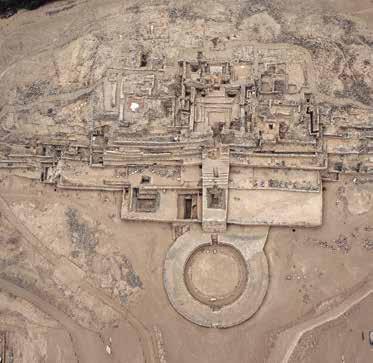
Aerial view of the Major Public Pyramidal Building with sunken circular plaza E1.
URBAN ROLE
The design and impressive building volume of this building stood out in the culture and natural landscape of the capital area.
In the space built, this building with the Major Public Pyramidal Building C1, La Cantera Public Pyramidal Building B10 and La Galería Public Pyramidal Building H1, defined the four cardinal axis of the urban layout of Caral’s upper half.


From the tip, the building’s operators had visual control over people circulating on the streets of Caral’s Urban Center.
 Detail of stonewall with snake designs made with pebbles.
View of the room with niches, on top of the building.
Detail of stonewall with snake designs made with pebbles.
View of the room with niches, on top of the building.
BUILDING SEQUENCE
A building sequence of the building’s last periods has been established through archaeological excavations.

In the Middle building period, the architectonic design was a quadrangular plan, with stepped pyramidal volume, and a main staircase located in the southern side of the building, which connected the monumental quincha rooms on the top of the building with the sunken circular plaza at the bottom. It also had a smaller architectural component, as an annex, in the western side.
In the Late building period they expanded the building; they kept the design and its orientation but they moved the building’s axis towards the east. On the top they built ceremonial halls, and other secondary rooms, all with stonewalls.

COMPONENTS

Sunken circular plaza
Frontal platforms
Side platforms
Main staircase
Secondary staircase
Ceremonial hall with fire pit and benches
Main room in the back of the Ceremonial Hall with secondary rooms
High room with niches
Eastern Ceremonial hall
Control room
West wing
Residential unit
Secondary rooms
Altar with underground duct and fire pit
East wing
BUILDING TECHNIQUE
In the Middle period they built quincha rooms on stone platforms joined with clay mortar. They obtained the stones from quarries, gullies and the riverbed. They made quincha of different sizes according the room use: for the Ceremonial Hall and ceremonial rooms they built with quincha of a monumental size, and for other rooms that had a secondary use, such as those in the back of the building, quincha was made in smaller sizes.
In the Late period they massively used stones from quarries to build retaining walls and double-face walls. To a smaller extent, and only in the last minor architectonic refurbishments, they used pebbles. They joined the stones with clay mortar of different colors and tones: yellow, with, red and beige.
They used “shicras” for all building deposits; and they placed large stones vertically in the walls of the main façade, at the corners of the platforms and in the stairs of the circular plaza.

1 3 2 4 5 7 9 11 13 14 15 10 12 6 8 Major Public Pyramidal Building With Sunken Circular Plaza E1 5 3 12 12 11
ARCHITECTURAL
FINDINGS ON THE MAJOR PUBLIC PYRAMIDAL BUILDING WITH SUNKEN CIRCULAR PLAZA E1


1 3 2 2 5 3 4 9 10 6 7 8 13 14 15
Four fragments of unfired clay sculptures, tubular shape.
Fragments of cylindricalshaped sculptures, possibly limbs.
Fragment of a sculpture (segment of a torso, lower part).
Fragment of a sculpture (leg).
Circular bead in mollusk shell.
Head of a sculpture, made of unfired clay.
Fragment of an anthropomorphic sculpture’s head made of unfired clay.
MINOR PUBLIC BUILDING E2-E3, “DUAL BUILDING”
Building located in the northeastern side of the upper half of Caral’s urban center, between the Major Public Pyramidal Building with circular plaza E1 and the Minor Public Pyramidal Building G. It is formed by two buildings that in a first period were separated, but after several refurbishments were restructured as a single complex building, with two independent access stairs.

SIZE
N-S: 35 m
E-W: 75.72 m
Height: 7.30 m

Surface: 2,630 m2

URBAN ROLE
The building was located in a strategic area, with visual control over the valley and two streets that lead to Caral’s urban center. Together with the Minor Pyramidal Building G1 they formed a shared public space, in a sector of the Great Central Plaza.
General view of the Minor Public Building E2-E3.
USE
During the first period the Building of the west side (E2), because of its architectonic design, building materials and the presence of fire pits and food waste it might have been a residence related to the Building of the East side (E3), which had a public ceremonial use. The proximity of the buildings suggests that they were conducted by the same social group. In the next period both were restructured as a single building, with ceremonial halls and a circular altar on the top, which are evidence of its public use.


CARAL 21 YEARS | 49
Quadrangular room of curved corners on the top of the Minor Public Building E2-E3.
BUILDING TECHNIQUE

During the first period, they used quincha to build walls of the Residential Building E2. During the second period, they buried the former build ings with dirt mixed with stones and cras, thus forming platforms defined with stonewalls. On the west side platform they built rooms with quincha and on the east side they built a cer emonial hall with stonewalls.
In the walls of both platforms they used cut stone and peb bles. The building’s walls were plastered with beige and yel low clay.

In the last period they cov ered the structures again with a single major plat form. On the platform they built ceremonial rooms with stonewalls and a circu lar fire altar with an under ground ventilation duct.

Edificio Público Menor E2-E3 4 2 2 3 6 5 3 1 H2 H3 H4 Huanca 0 300 m CARAL MAJOR PUBLIC PYRAMIDAL BUILDING WITH SUNKEN CIRCULAR PLAZA E1, “Major Pyramidal Building” RESIDENTIAL SUB-COMPLEX D1, “Elite Residential Sub-complex” MINOR PUBLIC PYRAMIDAL BUILDING G1, “Minor Pyramidal Building” MINOR PUBLIC BUILDING E2-E3, “Dual Building” MAJOR PUBLIC PYRAMIDAL BUILDING H1, “La Galería (The Gallery) Pyramidal Building” RESIDENTIAL UNIT F1, “Elite Residence” MINOR PUBLIC PYRAMIDAL BUILDING I1, “La Huanca (The standing stone) Pyramidal Building” RESIDENTIAL SUB-COMPLEX H2, H3 y H4 RESIDENTIAL SUB-COMPLEX A5 RESIDENTIAL SUB-COMPLEX A8 RESIDENTIAL UNIT X4 RESIDENTIAL UNIT X2 RESIDENTIAL UNIT X3 RESIDENTIAL UNIT D4 RESIDENTIAL UNIT D3 RESIDENTIAL UNIT X1 RESIDENTIAL UNITS I2, “Elite Residential I2 MAJOR RESIDENTIAL COMPLEX A RESIDENTIAL UNIT Z RESIDENTIAL UNITS B1and B2 MAJOR PUBLIC PYRAMIDAL BUILDING B, “La Cantera (The Quarry) pyramidal building” MAJOR PUBLIC PYRAMIDAL BUILDING C1, “Central pyramidal building” PUBLIC PYRAMIDAL BUILDING C3 CEREMONIAL PLATFORM and SUNKEN CIRCULAR PLAZA C2, “Integration plaza or Tinkuy Mitu Cancha MINOR PUBLIC PYRAMIDAL BUILDING C4, “Residential and public building to access the Core Area” RESIDENTIAL SUB-COMPLEX B7 and B8, “Elite residential of the South Street RESIDENTIAL SUB-COMPLEX C5, “Residential sub-complex of Integración Social street RESIDENTIAL UNIT B9 MAJOR PUBLIC BUILDING OF EXTENDED ARCHITECTURE WITH PLAZA L, “Amphitheater Temple” MINOR PUBLIC BUILDING K MINOR PUBLIC BUILDING N, “La Banqueta (The Bench) Temple MINOR PUBLIC BUILDING M MINOR PUBLIC BUILDING O MINOR PUBLIC BUILDING P, “Circular Altar Temple RESIDENTIAL COMPLEX NN2, “Minor Residential complex” MINOR PUBLIC BUILDING R, “Los Fogones (The Firepits) building” RESIDENTIAL UNIT Q RESIDENTIAL UNIT B5 RESIDENTIAL UNIT B4 RESIDENTIAL UNIT B6 RESIDENTIAL UNIT B2 MINOR PUBLIC BUILDING T, “Quadrangular Altar building” MINOR PUBLIC BUILDING S, “Minor Ceremonial building” RESIDENTIAL SUB-COMPLEX V, “Residences” RESIDENTIAL COMPLEXES OF THE LOWER HALF OUTSKIRTS W1 RESIDENTIAL COMPLEXES OF THE LOWER HALF OUTSKIRTS W2 RESIDENTIAL COMPLEXES OF THE UPPER HALF OUTSKIRTS ARTISANAL SPECIALIZATION WORKSHOP J MINOR PUBLIC BUILDING U, “Minor ceremonial building” MINOR PUBLIC BUILDING X6, “Public Building of the outskirts” RESIDENTIAL SUB-COMPLEX X7 RESIDENTIAL SUB-COMPLEX D2 RESIDENTIAL SUB-COMPLEX A4 RESIDENTIAL SUB-COMPLEX A2 RESIDENTIAL SUB-COMPLEX A1 RESIDENTIAL SUB-COMPLEX A5 RESIDENTIAL SUB-COMPLEX A3 ARTISANAL SPECIALIZATION WORKSHOP K1
FINDINGS IN THE MINOR PUBLIC BUILDING E2-E3


staircase Platforms Ceremonial hall with fire pit and benches Secondary rooms Circular altar Ceremonial room COMPONENTS ARCHITECTURAL 1 2 3 5 6 4
Main
Walls and floor of room on the top of the building.
Round stone beads.
Fragment of anthropomorphic unfired clay sculpture.
4
Beige unfired clay, modeled and painted white.
CIRCULAR ALTAR OF MINOR PUBLIC BUILDING E2-E3
It was built in the southeastern side of the Minor Public Ceremonial building E2, as an architectural component for private ceremonies, controlled by the building’s users.
USE

Building use for private ceremonial activities. In these ceremonies, conducted around the central fire pit, they burnt offerings related to a deity worship.

52 | CARAL 21 YEARS
SIZE Height: 2 m N-S: 3.7 m E-W: 3.4 m Fire pit: 0.50 m
Detail of the circular altar of the Minor Public Building E2-E3.
BUILDING TECHNIQUE

They built the circular altar with pebbles and cut stones, joined with mortar made of gray clay and couch grass. They plastered it with yellow and beige clay. The circular fire pit located in the middle of the altar has a 50 cm diameter.

INTERNAL ORGANIZATION OF THE CIRCULAR ALTAR
In the Circular Altar they applied a complex structural design. They made two underground ventilation ducts to drive airflows. Furthermore, they made ducts thinner to produce a Venturi effect, thus intensifying the fire.

CARAL 21 YEARS | 53
Cut A - A1
Fire pit
Wall that defines the altar Platform
Natural surface A
Duct Duct A 1 0 300 m
CARAL
MAJOR PUBLIC PYRAMIDAL BUILDING CIRCULAR PLAZA E1, “Major Pyramidal Building”
RESIDENTIAL SUB-COMPLEX D1, “Elite Residential Sub-complex” MINOR PUBLIC PYRAMIDAL BUILDING G1, “Minor Pyramidal Building”
MINOR PUBLIC BUILDING E2-E3, “Dual Building” MAJOR PUBLIC PYRAMIDAL BUILDING H1, “La Galería (The Gallery) Pyramidal Building”
RESIDENTIAL UNIT F1, “Elite Residence” MINOR PUBLIC PYRAMIDAL BUILDING I1, “La Huanca (The standing stone) Pyramidal Building” RESIDENTIAL SUB-COMPLEX H2, H3 y H4
RESIDENTIAL SUB-COMPLEX A5
RESIDENTIAL SUB-COMPLEX A8 RESIDENTIAL UNIT X4 RESIDENTIAL RESIDENTIAL UNIT X3
RESIDENTIAL UNIT D4 RESIDENTIAL UNIT D3 RESIDENTIAL UNIT X1 RESIDENTIAL UNITS I2, “Elite Residential I2
MAJOR RESIDENTIAL COMPLEX A
RESIDENTIAL UNIT RESIDENTIAL UNITS B1and B2
PYRAMIDAL BUILDING B, “La Cantera (The Quarry) pyramidal building”
PYRAMIDAL BUILDING C1, “Central pyramidal building”
PUBLIC PYRAMIDAL BUILDING C3 CEREMONIAL PLATFORM and SUNKEN CIRCULAR PLAZA C2, “Integration plaza or Tinkuy Mitu Cancha
BUILDING C4, “Residential and public building to access the Core Area” RESIDENTIAL SUB-COMPLEX B7 and B8, “Elite residential of the South Street
RESIDENTIAL C5, “Residential sub-complex of Integración Social street RESIDENTIAL UNIT B9 MAJOR PUBLIC BUILDING OF ARCHITECTURE WITH PLAZA L, “Amphitheater Temple” MINOR PUBLIC BUILDING K
MINOR PUBLIC BUILDING N, “La Banqueta (The Bench) Temple MINOR PUBLIC BUILDING M
MINOR PUBLIC BUILDING O
MINOR PUBLIC BUILDING P, “Circular Altar Temple
RESIDENTIAL COMPLEX NN2, “Minor Residential complex”
MINOR PUBLIC BUILDING R, “Los Fogones (The Firepits) building” RESIDENTIAL UNIT Q
RESIDENTIAL UNIT B5
UNIT B4
RESIDENTIAL UNIT B6 RESIDENTIAL UNIT B2 MINOR PUBLIC BUILDING T, “Quadrangular Altar building” MINOR PUBLIC BUILDING S, “Minor Ceremonial building”
RESIDENTIAL SUB-COMPLEX V, “Residences”
RESIDENTIAL COMPLEXES OF THE LOWER HALF OUTSKIRTS W1 RESIDENTIAL COMPLEXES OF THE LOWER HALF OUTSKIRTS W2
OF THE UPPER HALF OUTSKIRTS ARTISANAL SPECIALIZATION WORKSHOP
MINOR PUBLIC BUILDING U, building”
MINOR PUBLIC BUILDING X6, “Public Building of the outskirts” RESIDENTIAL SUB-COMPLEX X7 RESIDENTIAL SUB-COMPLEX D2 RESIDENTIAL SUB-COMPLEX A4
RESIDENTIAL SUB-COMPLEX A2 RESIDENTIAL SUB-COMPLEX A1 RESIDENTIAL SUB-COMPLEX A5 RESIDENTIAL ARTISANAL SPECIALIZATION WORKSHOP K1
Economic aspects
The population of Caral’s urban center during the Initial Formative period lived based on a productive economy with surpluses managed by the settlement’s authorities. Supe residents exploited the resources of one of the planet’s most productive seas and used the valley lands (mostly plain and easy to irrigate) as agricultural fields, which they irrigated with river and spring water. In this areas of differentiated production (fishing in the coastline and agricultural –with a variety of products- in coastline sections, and the lower, medium-lower and medium-higher sections of the valley). They settled towns devoted to specialized production, based on which they developed a complementary (fishing-agricultural) economy, articulated through
the exchange between the coastline and valley settlements (Shady 2014: 80).
The work of fishermen and farmers, technological development and exchange supported the economy and the endeavors of several specialists, among them: the authorities in charge of managing the city and its property; representatives leading social groups or lineages and governing each public building; producers of knowledge applied in several fields (astronomy, genetics, agrarian technology, medicine, architectonic constructions, information recording in quipus, music and art); traders of products from several ecological areas and, last but not least, craftsmen devoted to processing and weaving with cotton, reed and totora fiber, as well as to manufacturing mates, wooden artifacts and making beads and personal ornaments with shells, quartz and precious stones (Shady 2006: 61).
Social Aspects
Caral civilization was characterized by a hierarchical social system, related to the political organization and with the specialization of its residents (Shady et al. 2009: 28-30, Shady 2014: 94-95), which resulted in different social classes. There was a centralized organization with political authorities, which forms a state-like social system. Caral’s urban cen-
Political aspects
Caral’s social organization was associated to a political management supported on religious ideology. The population was ruled under this social system. Political authorities of the local and central State governed through the ayllus’ organized social structure –which continued into Inca times- with a vision
ter was managed under this socio-political-administrative system, which became more complex over time (Shady 2014: 65). The confluence of domestic units with monumental public buildings for several activities reflects work specialization and the social structure of Caral.
This social system, with a strong religious ideology transcended time and space, and many aspects lasted up to the time of the Inca Empire (Shady 2003: 98, 99).

of collective ownership of land, water and resources, instead of individual. A collective organization was necessary to live under appropriate conditions in the Andean territory.
Political authorities of the Supe valley integrated in a single macro system at a State, organized and hierarchized level. Authorities of the urban centers or pachacas; both authorities of the “sayas” (one by each valley bank) and the central authority or “hunu”.

54 | CARAL 21 YEARS
Ideological aspects
The social organization, based on ayllus, and the political organization of pachacas, supported by a strong ideology, formed the centralized State. Each one of these organizations had particular gods and shared general deities and symbolic representations of religious and cosmologic precepts. Periodical ceremonies were conducted to integrate the population with rites, music and dances (Shady 2014: 92).


CARAL 21 YEARS | 55
Recreation of activities related to astronomy: based on the geoglyph of the quadrangular spiral.
The Sacred City of Caral in Caral civilization

Caral urban center was part of the civilization that originated in the Supe valley, through an organized and hierarchical, and which transcended the whole Andean area. Based on the cultural and time-related information, available to date, it may be inferred that this system progressively influenced the social system of Supe; first, it influenced the populations of immediate valleys, Pativilca, Fortaleza, Huaura and Chancay; then, its influence expanded across the South to the populations of Chillón and Rímac valleys.
The results of the investigations, we are carrying out in the Supe valley, indicate
the development of Caral as civilization is older, and that this area became more prestigious. Locally, the Sacred City of Caral, located in the mid-low section of the Supe valley, would have been the most outstanding urban center of this civilization.
From the information that is being recovered in the Sacred City of Caral, as compared to that of other settlements, we infer that Caral society knew the Andean territory and the geographical diversity of localities and regions with different ecological floors; actively participated in the set up of regional and inter-region-
al interaction networks to promote access to resources and goods produced in the several areas; built the first planned city of the new world, set the structural organizational foundations of what would be the shared social and political organization in the Central Andes; produced –through specialists- scientific and technological knowledge of a great impact and social significance, which were assumed by other societies and improved with the experience of its implementation over time (such as the case of cotton of several natural colors, the quipu, the geoglyphs, and the seismic-resistant building technologies, etc.).
56 | CARAL 21 YEARS
The sacred city of Caral and the Supe valley.

CARAL 21 YEARS | 57
Possible paths between the cities of the Supe valley and other cities of the Huaura and Pativilca valleys.
CHUPACIGARRO


URBAN CENTER B
View of the Main Building, Public Building of Extended Architecture with sunken circular plaza A1.
Location
Chupacigarro archaeological settlement can be accessed taking the exit at Km 184 of the North Pan-American highway, and then continuing for 19 kilometers towards Ámbar.

CHUPACIGARRO URBAN CENTER LOCATION MAP
Polygonal
Occupation site
Paved road
Supe River
Political location:
Department: Lima / Province:
Barranca / District: Supe
Geographical location:
Zone: 18S
Reference system: WGS84
UTM coordinates:
223 275.01 E / 8 795 132.15 N
Average altitude: 325 m a. s. l.
Urban center area: 38.59 ha
Geographical Aspects
Settlement located on fluvial and alluvial terraces, between the Mulato (East) and Miraya (West) mountains; both separated by stream channels.


The agricultural fields are in the northern area of the valley and the Mulato Mountain is to the east, next to the sacred city of Caral.
Its inhabitants chose a strategic place for the relationship with people from the lower section of the Supe valley and the Huaura coastline, which was their source of marine products. Furthermore, they had immediate access to the riverside forest, to puquios or springs, to quarries and farmland.
The settlement is not visible from the valley; it is possible that it was part of an extension of Sacred City of Caral, maybe used for more private or religious purposes.
CARAL 21 YEARS | 59
Location of Chupacigarro in the “Capital area”.
CHUPACIGARRO
CARAL
PUEBLO NUEVO MIRAYA
LURIHUASI
ALLPACOTO
LLAQTA
CERRO COLORADO
CHUPACIGARRO
Chupacigarro urban center.
Background
Carlos Williams and Manuel Merino registered this place as Chupacigarro Centro (Williams and Merino 1979). Later, Frederic Engel dug a trench in the main building of the settlement and published this building’s plan, with some comments about the society that built it (Engel 1987). Elzbieta Zechenter also obtained samples for radiocarbon dating of the site, which result was 3980 +- 90 BP (2571 to 2291 B.C.) (Zechenter, 1988). Ruth Shady and her team of investigators examined the place, as part of the exploration they did in the Supe valley from 1994 to 1996 (Shady et al. 2000).
ZAC started working in Chupacigarro in 1999, when 50% of the site had already been destroyed by a family, which affected the monuments and other archaeological evidences. Though Chupacigarro was declared cultural heritage in 2002, and was transferred to the National Institute of Culture in 2006, the legal procedures initiated to protect the site continue because the site continues being periodically affected, which has been brought to Court.
With the beginning of investigations it was possible to strengthen the site’s protection and deepen the knowl-
edge on Caral civilization. The first intervention, focused on identifying the urban design and studying the main building was in charge of Marco Machacuay (Machacuay, 2008).

Such task and the subsequent works -which continue to date- are being carried out by ZAC’s team of investigators.
 Investigaciones en el sector C, 2008.
Chupacigarro archaeological site and its cultural and natural environment; the Main Building A1 and its circular plaza are in the forefront. At the back, the sacred city of Caral.
Investigaciones en el sector C, 2008.
Chupacigarro archaeological site and its cultural and natural environment; the Main Building A1 and its circular plaza are in the forefront. At the back, the sacred city of Caral.
Chupacigarro archaeological site
The site was declared National Cultural Heritage by the National Director’s Resolution 720/INC, dated August 01, 2002.
In the archaeological site there are components of the four periods of the Andean cultural process: the largest one, which occupies the site’s largest portion, correspond to the Initial Formative period.
Figurative and lineal geoglyphs of the Early Formative

period have been identified, as well as semi-circles made of stone without mortar, distributed in the open space, flat, located at the back of the settlement. A path has also been identified, which connects the site with the Huara valley and the coastline and is being used since the Initial Formative period to date. There is a group of rooms (Sector E) and terraces in the Miraya mountain slope, which corresponds to the Early Intermediate period. The five mounds of stones, surrounded by the current farmland of squatters, have archaeological material from
the late Middle Horizon. The sectors F, G, H and I –not yet investigated- from the Initial Formative period were identified at the northern end of the site. In the built design, the buildings’ main facades were oriented towards a central public space.
The following public buildings are located in the settlement’s southern area: Pyramidal Building of extended architecture and sunken circular plaza A1, Minor Public Buildings B7, B8 and B9; Public Buildings C10, C11, C12 and C13; and Minor Public Building D14.
CARAL 21 YEARS | 61
Chupacigarro geoglyph.
Urban design of the Initial Formative period


The urban center of the Initial Formative period covered 38.59 hectares. Two building clusters are related to the open public space. Four sub-complexes have been identified in the southern area, sectors A, B, C and D. In the northern side, on the alluvial terraces, there is another block of buildings, sectors F, G, H and I, the most affected by the construction.

MINOR PUBLIC BUILDING A5

MINOR PUBLIC BUILDING B8
MINOR PUBLIC BUILDING B9
PUBLIC BUILDING C10A
PUBLIC BUILDING C11
PUBLIC BUILDING C12
PUBLIC BUILDING C13
PUBLIC BUILDING OF EXTENDED ARCHITECTURE WITH SUNKEN CIRCULAR PLAZA A1
MINOR PUBLIC BUILDING A4
MINOR PUBLIC BUILDING A5
2 5 4 9 3 1 4 2 5 3 6
MINOR PUBLIC BUILDING B8
PUBLIC BUILDING OF EXTENDED ARCHITECTURE WITH SUNKEN CIRCULAR PLAZA A1 (“MAIN BUILDING”)
MINOR PUBLIC BUILDING A4
PUBLIC
BUILDING F16
7 8 9
MINOR PUBLIC BUILDING D14


Sector E Sector A Sector B Sector C Sector C Sector F A2 A3 MA MB MB M1 M4 T4 T1 H18 M2 MC MG MF ME MD A B7 C10 B AR 3 AR 2 AR 1 M5 T5 D15 0 200 m CHUPACIGARRO N PUBLIC BUILDING OF EXTENDED ARCHITECTURE WITH SUNKEN CIRCULAR PLAZA A1 “MAIN BUILDING”) MINOR PUBLIC BUILDING A4 MINOR PUBLIC BUILDING B8 MINOR PUBLIC BUILDING D14 MINOR PUBLIC BUILDING A5 PUBLIC BUILDING C10A MINOR PUBLIC BUILDING B9 PUBLIC BUILDING C11 PUBLIC BUILDING C16 PUBLIC BUILDING C12 PUBLIC BUILDING C13 MINOR PUBLIC PUBLIC BUILDING C12 PUBLIC BUILDING C13 PUBLIC BUILDING C11 7 6 1 8
BUILDING C10A
PUBLIC
3D Reconstruction of the Chupacigarro urban works.
SUB-COMPLEX OF BUILDINGS A


 Detail of access stairs to the sunken circular plaza of the Chupacigarro Public Building of extended architecture.
bead.


FINDINGS IN THE PUBLIC BUILDING OF EXTENDED ARCHITECTURE WITH SUNKEN CIRCULAR PLAZA A1


Quartz foliaceus point. Chrysocolla beads


CARAL 21 YEARS | 65
Chrysocolla
Fragment of a shell bead, roundshaped. Spondylus sp. pendant
Bone needle.
Sector E Sector A Sector B Sector C Sector C Sector F A2 A3 MA MB MB M1 M4 T4 T1 H18 M2 MC MG MF ME MD A B7 C10 B AR 3 AR 2 AR 1 M5 T5 D15 0 200 m CHUPACIGARRO N PUBLIC BUILDING OF EXTENDED ARCHITECTURE WITH SUNKEN CIRCULAR PLAZA A1 “MAIN BUILDING”) MINOR PUBLIC BUILDING A4 MINOR PUBLIC BUILDING B8 MINOR PUBLIC BUILDING D14 MINOR PUBLIC BUILDING A5 PUBLIC BUILDING C10A MINOR PUBLIC BUILDING B9 PUBLIC BUILDING C11 PUBLIC BUILDING C16 PUBLIC BUILDING C12 PUBLIC BUILDING C13
Public building of extended architecture with sunken circular plaza A1.
Sector A is comprised by six buildings:
Building A1: Public Pyramidal Building of extended architecture with sunken circular plaza.
Building A2: Residential Unit, comprised by small rooms with compartments that communicate with each other. Not investigated.
Building A3: Residential unit, with main and secondary rooms. Not investigated.
Building A4: Minor Public Building.
Building A5: Minor Public Building.
Building A6: Residential Unit. It is destroyed. Not investigated.
Frieze fragment shaped as a cross or “c hacana”, Public building of extended architecture with sunken circular plaza A1.


66 | CARAL 21 YEARS
Ceremonial hall with benches and central fire pit. Public Building of extended architecture with sunken circular plaza A1.


CARAL 21 YEARS | 67 Minor Public Building A5 Minor Public Building A4 Sector E Sector A Sector B Sector C Sector C Sector F A2 A3 MA MB MB M1 M4 T4 T1 H18 M2 MC MG MF ME MD A B7 C10 B AR 3 AR 2 AR 1 M5 T5 D15 0 200 m CHUPACIGARRO N PUBLIC BUILDING OF EXTENDED ARCHITECTURE WITH SUNKEN CIRCULAR PLAZA A1 “MAIN BUILDING”) MINOR PUBLIC BUILDING A4 MINOR PUBLIC BUILDING B8 MINOR PUBLIC BUILDING D14 MINOR PUBLIC BUILDING A5 PUBLIC BUILDING C10A MINOR PUBLIC BUILDING B9 PUBLIC BUILDING C11 PUBLIC BUILDING C16 PUBLIC BUILDING C12 PUBLIC BUILDING C13
SUB-COMPLEX OF BUILDINGS B

Three Minor Public Buildings on a fluvial terrace. Minor Public buildings 8 and 9, which have secondary rooms, stand out for their location and extension. In the building 7, only one room –in very bad condition- has been preserved.
Façade of Minor Public Building B8.


CARAL 21 YEARS | 69
Façade of Minor Public Building B9.
Detail of a wall of Minor Public Building B8.
Detail of rooms of Minor Public Building B9.
FINDINGS IN THE MINOR PUBLIC BUILDING B8


 Minor Public Building B8
Compressed achira (arrowroot) and willow leafs, associated to a reed mat fragment.
Stone axe with slot.
Stone foliaceus point.
Fragment of pendant, of Oliva peruviana (sea snails).
Stone hammer.
Projectile of boleadora.
Minor Public Building B8
Compressed achira (arrowroot) and willow leafs, associated to a reed mat fragment.
Stone axe with slot.
Stone foliaceus point.
Fragment of pendant, of Oliva peruviana (sea snails).
Stone hammer.
Projectile of boleadora.
FINDINGS IN THE MINOR PUBLIC BUILDING B9


 Minor Public Building B9.
Stone axe with slot.
Fragment of foliaceus point.
Minor Public Building B9.
Stone axe with slot.
Fragment of foliaceus point.
SUB-COMPLEX OF BUILDINGS C
Comprised by four public buildings and two residential sub-complexes. Buildings were built on a fluvial terrace, which was adapted with retaining walls to expand the space to be built.

72 | CARAL 21 YEARS
Public Building C10.
Public Building with two components, C10A and C10B, located in the edge of a terrace. Only the first one has been excavated.


The building C10A was built on a 34 m long platform, adapted on the natural terrace. On the platform they built a quadrangular room, 11 m long, with benches and central fire pit. Behind the ceremonial hall there are two smaller rooms, one next to the other. In the northern area there were other small and secondary rooms and spaces.
Initially, the buildings C10A and C10B were separated, but then they transformed them in a single one, which was more complex.
Public Building adapted on a wide platform built on a terrace. A central access stair, a ceremonial hall, a rear room and side rooms have been identified.
CARAL 21 YEARS | 73
Public Building C10
Entrance Façade of Public Building C11.
Detail of quincha wall of Public Building C10 A.
Detail of room with fire pits of Public Building C11.
Public Building C11
FINDINGS IN PUBLIC BUILDINGS


C10 AND C11
Ceremonial slate palettes, with geometric engravings.


 Public Building C11.
Public Building C10.
Shellfish bead.
Hand mill.
Smasher.
Stone polisher.
Public Building C11.
Public Building C10.
Shellfish bead.
Hand mill.
Smasher.
Stone polisher.
Public Building C12
Public building with a ceremonial hall, a rear room and side rooms in the ancient periods; and a circular altar with ventilation duct in a latter period.


Public Building C13


Public Building with a series of annexes in the back.
Public Building C12
Platform and access staircase to the ceremonial hall of Public Building C13.
Public Building C12
Public Building C13.
Public Building C13.
Sector E Sector A Sector B Sector C Sector C Sector F A2 A3 MA MB MB M1 M4 T4 T1 H18 M2 MC MG MF ME MD B7 C10 B AR 3 AR 2 AR 1 M5 T5 D15 200 CHUPACIGARRO N PUBLIC BUILDING OF EXTENDED ARCHITECTURE WITH SUNKEN CIRCULAR PLAZA A1 “MAIN BUILDING”) MINOR PUBLIC BUILDING A4 MINOR PUBLIC BUILDING B8 MINOR PUBLIC BUILDING D14 MINOR PUBLIC BUILDING A5 PUBLIC BUILDING C10A MINOR PUBLIC BUILDING B9 PUBLIC BUILDING C11 PUBLIC BUILDING C16 PUBLIC BUILDING C12 PUBLIC BUILDING C13
SUB-COMPLEX OF BUILDINGS D
There are two small buildings (D14 and D15), built on a rocky foothill, high and narrow, of Miraya Mountain. They cover approximately 270 m2.


Only the Minor Public building D14, which had three building stages, has been investigated.

In the first stage, they built quincha rooms on a quadrangular plan, on top of the rocky foothill. Of these rooms only fragments of floors and pole holes have been preserved. In the second period they built a low terrace to adapt the top of the rocky foothill. On this terrace they built a quincha building with two rooms, one towards the east and the
other one towards the north. Both rooms had stairs in their entrance. In the third and last period they added two stone terraces to the existing one, providing the building with a stepped configuration. On the top they built a

new building with two rooms, which had the same orientation and size of the former one, but with stonewalls. In the room facing the east they made a central fire pit and in the room towards the north a small bench.
 Detail of the top of Public Building D14.
Public Building D14.
Detail of the top of Public Building D14.
Public Building D14.
Sector E Sector A Sector B Sector C Sector C Sector F A2 A3 MA MB MB M1 M4 T4 T1 H18 M2 MC MG MF ME MD A B7 C10 B AR 3 AR 2 AR M5 T5 D15 200 CHUPACIGARRO N PUBLIC BUILDING OF EXTENDED ARCHITECTURE WITH SUNKEN CIRCULAR PLAZA A1 “MAIN BUILDING”) MINOR PUBLIC BUILDING A4 MINOR PUBLIC BUILDING B8 MINOR PUBLIC BUILDING D14 MINOR PUBLIC BUILDING A5 PUBLIC BUILDING C10A MINOR PUBLIC BUILDING B9 PUBLIC BUILDING C11 PUBLIC BUILDING C16 PUBLIC BUILDING C12 PUBLIC BUILDING C13
PUBLIC BUILDING F16
Building formed by two quadrangular platforms, 30 m long and 24 m wide, arranged in a step way on a geological terrace. On the top of the platforms there is evidence of a ceremonial hall. They placed vertical stones on the corners of and on specific sections of the wall. The central staircase, eight meters wide, has a handle. Currently there are squatters in the area, which impedes further investigating the building.


Sector E Sector A Sector B Sector C Sector C Sector F A2 A3 MA MB MB M1 M4 T4 T1 H18 M2 MC MG MF ME MD A B7 C10 B AR 3 AR 2 AR 1 M5 T5 0 200 m CHUPACIGARRO N PUBLIC BUILDING OF EXTENDED ARCHITECTURE WITH SUNKEN CIRCULAR PLAZA A1 “MAIN BUILDING”) MINOR PUBLIC BUILDING A4 MINOR PUBLIC BUILDING B8 MINOR PUBLIC BUILDING D14 MINOR PUBLIC BUILDING A5 PUBLIC BUILDING C10A MINOR PUBLIC BUILDING B9 PUBLIC BUILDING C11 PUBLIC BUILDING C16 PUBLIC BUILDING C12 PUBLIC BUILDING C13
Detail of the wall of Public Building F16.
Public Building F16.
Economic Aspects
Livelihood products for this settlement’s residents came from agro-fishing activities. Remains of squash, beans, achira, lima beans and avocado; among others; as well as timber tools that were used for agricultural tasks. Furthermore, there are several remains showing consumption of anchovies and shellfish, mainly Choromytylus sp. and Mesodesma sp.
Social Aspects
Activities conducted in the Chupacigarro urban center were closely related to those of the sacred city of Caral but with a more private and religious character, considering that the settlement was not visible from the valley and it lacked major pyramidal buildings. Urban planning was very similar to that of the lower half of the Sacred City of Caral.


78 | CARAL 21 YEARS
Public Building of Extended Architecture with Sunken Circular Plaza A1, Chupacigarro.
Monolyths of the sunken circular plaza.
Interpretation in relation to the Sacred City of Caral


The Chupacigarro urban center was integrated in the capital area of the Supe valley and was closely related to the authorities of the city of Caral. Evidence of ceremonial activities was found in most of the buildings. Some buildings were probably workshops to make worship objects. In the main building, a decoration in relief with an Andean cross design was found, and in the circular plaza, monoliths flanking the stairs. However, there were no high Minor Public Buildings and the settlement was not visible from the valley. Moreover, it has a similar architecture to the lower half of the sacred city of Caral.
In the forefront we observe rooms of the Chupacigarro archaeological site. In the background, Caral archaeological site.
CARAL 21 YEARS | 79
C MIRAYA URBAN CENTER

 Main façade of the Major Public Pyramidal Building A1 and the sequence of sunken circular plazas.
Location
The Miraya archaeological settlement can be accessed taking the exit at Km 184 of the North Pan-American highway, and then continuing for 19 kilometers taking the road to Ámbar, towards the intersection that goes across the Supe Rover, and arrive in the site after 1 kilometer.

Political location:
Department: Lima
Province: Barranca
District: Supe
Geographical location:
Zone: 18S
Reference system: WGS84
UTM coordinates: 222 375.01 E
8 795 762.15 N
Average altitude: 350 m a. s. l.
Urban center surface: 33.90 Ha
Geographical Aspects
Miraya Urban Center is located in the middle section left bank of the Supe river, 2.5 kilometers to the west of the sacred city of Caral, surrounded by a chain of mountains. It was built on alluvial terraces from the northern area of the Miraya Mountain, which gave it its name.

Architectural components of the archaeological site were placed on the terraces and in the neighboring mountains of the valley.
Its residents used the lands of the valley, the water resources of the river and springs or puquios, as well as stones from quarries, abundant clay and fauna and flora of the riverside forest and the hills.

CARAL 21 YEARS | 81
MIRAYA URBAN CENTER LOCATION
MAP Polygonal Occupation site Paved road Supe River
Location of Miraya in the “Capital area”.
CARAL
PUEBLO NUEVO
LURIHUASI
ALLPACOTO
LLAQTA
CERRO COLORADO
CHUPACIGARRO
MIRAYA
Miraya Urban Center.
Background
Miraya archaeological site was declared National Cultural Heritage by National Director’s Resolution Nº 720/INC, dated August 1, 2002.


Carlos Williams and Manuel Merino registered the site. In 1984, Elzbieta Zechenter conducted excavations to obtain samples for radiocarbon dating and materials show-
ing the ecology and diet of the site’s residents. Furthermore, Miraya urban center was described in the exploration carried out by Shady and her team between 1994 and 1995, as well as its features, similarities and differences in the built space designed and the several spaces comprising it, as compared with other settlements in the Supe valley.
The constant agricultural progress and the use of the archaeological site’s internal spaces to dehydrate products such as maize and paprika pepper and the barns built for livestock breeding have damaged the cultural heritage, and thus in June 2002 investigations were initiated in this settlement with monumental architecture to stop its destruction and disseminate its significance.
82 | CARAL 21 YEARS
Excavations of the Major Public Pyramidal Building with Plaza, Subsector A1, 2006.
Miraya archaeological site, 2006.
Miraya archaeological site

The site is comprised by architectonic blocks, adapted to the land topography, which correspond to the Initial and Early Formative periods. Furthermore, there is evidence of the architecture of other periods of the Andean cultural process, such as geoglyphs in the Miraya mountain slopes, isolated buildings and arrangements on top of the mountain chain.
However, the components of the Initial Formative components related with Caral civilization stand out.
CARAL 21 YEARS | 83
Core area of the Miraya archaeological site, September 2015.
Urban design of the initial Formative period

An upper and a lower half can be observed; a design applied following the principles of social organization of Caral civilization, and that was going to be continued by other societies on the Andean cultural process.

In both halves they built blocks of houses made of quincha on the ground or on low stone platforms, as well as public buildings of different sizes and architectural components, all of which show shared cultural elements.
In the upper half the Major Public Pyramidal Building C4 (Dual Pyramidal Building) stands out, which marks the central axis around which they built three smaller public pyramidal buildings: C2, C3 and C5. These buildings were located around a central space, where there formerly was a block of residences that were destroyed (C1, C6). Residential complexes C7 and C8 are located to the northeast of the upper half, still not investigated.
In the lower half of the Major Public Pyramidal Building A1 and a sunken circular plaza with stairs led by great vertical

stones. This building forms a block with other two smaller public pyramidal buildings A2, A5 and a possible residential area, A3. Excavations have been focused on the Building A1; in buildings A2 and A3 only have conducted targeted excavations.


Changes in designs, styles and technologies that correspond to a time sequence are observed in all buildings. Monumental quincha prevails in the first public buildings, built on high platforms. In the following periods they increased the buildings and replaced the quincha rooms with others made of stone. Monumental architecture and overlapped platforms were built with stone on structured deposits of “s hicras”, fiber bags with stones.
The Minor Public pyramidal building F1 and the residential sub-complex D, E and H are located in the chain of natural elevations, located in the outskirts, and has been adapted to the topography. To date only the F1 building and the Residential complex H have been investigated.
84 | CARAL 21 YEARS
MINOR PUBLIC PYRAMIDAL BUILDING C3
MINOR PUBLIC PYRAMIDAL BUILDING F1 RESIDENTIAL SUBCOMPLEX C1
MAJOR PUBLIC PYRAMIDAL BUILDING C4, “Dual Pyramidal Building”


MAJOR PUBLIC PYRAMIDAL BUILDING WITH SUNKEN CIRCULAR PLAZA A1


MINOR PUBLIC PYRAMIDAL BUILDING C5, “Las Esculturas (The sculptures) Building”
CARAL 21 YEARS | 85 0 200 m MIRAYA N F2 E D2 D1 C2 B2 A5 G C8 C1 C7 C6 Minor Public Pyramidal Building F1 Major Public Pyramidal Building with Sunken Circular Plaza A1 Minor Public Pyramidal Building C3 Major Public Pyramidal Building C4, “Dual Pyramidal Building” Residential Sub-complex C1 Minor Public Pyramidal Building C5, “Las Esculturas (The Sculptures) Building” Building A4 Residential sub-complex A3 Minor Public Pyramidal Building A2 Residential complex H
Minor Public Pyramidal Building F1
Major Public Pyramidal Building with Sunken Circular Plaza A1
Minor Public Pyramidal Building C3
Major Public Pyramidal Building C4, “Dual Pyramidal Building”
Residential Sub-complex C1
Minor Public Pyramidal Building C5, “Las Esculturas (The Sculptures) Building”
Minor Public Building A4
Minor Public Pyramidal Building with Sunken Circular Plaza,

embedded in a quadrangular platform B1
Residential sub-complex A3
Minor Public Pyramidal Building A2
Residential complex H
86 | CARAL 21 YEARS 1 2 1 3 5 7 9 2 4 6 8 10 11
3D Reconstruction of the Miraya urban works.

CARAL 21 YEARS | 87 10 11 5 9 4 6 8 7 3
It is formed by residences of quincha walls and low stone platforms, located in the central part of the upper half of the city.
In a first period, in all this space, they built residential units of quadrangular plans and thin quincha walls. Small evidence is left from these rooms, such as fragments of floors, and wall plasters.


In a second period they built a not very high stone platform that covered the former architecture. On this platform they built new rooms, also with quincha walls.
The stone platform was remodeled several times, to expand it horizontally. In the last expansion they used larger stones, imitating the building style of public buildings. The staircase of the main façade was also remodeled in each platform expansion.
Last but not least, the sub-complex was destroyed and the whole space was leveled to have a central public area, around which they made the public buildings of the upper half of the city.
RESIDENTIAL SUB-COMPLEX C1
Platform with vertical stones.
Residential Sub-complex C1.
FINDINGS IN THE RESIDENTIAL SUB-COMPLEX C1
Fabric fragment, made with beige cotton fiber. With twining techniques and transposed warps they generated a geometric design.

Second period of the Residential Sub-complex C1.

Quena fragment, made with a reed stem, with Ushaped bezel.


Eight to twelve-year old male individual, with a blunt injury in the skull, potential cause of death. He was placed inside an oval-shaped hole covered by stones, on which they built a retaining wall that was part of a main façade, during the building’s architectonic renewal.

Needle worked in mammal bone.
Minor Public Pyramidal Building F1 Major Public Pyramidal Building with Sunken Circular Plaza A1 Minor Public Pyramidal Building C3 Major Public Pyramidal Building C4, “Dual Pyramidal Building” Residential Sub-complex C1 Minor Public Pyramidal Building C5, “Las Esculturas (The Sculptures) Building” Minor Public Building A4 Minor Public Pyramidal Building with Sunken Circular Plaza, embedded in a quadrangular platform B1 Residential sub-complex A3 Minor Public Pyramidal Building A2 Residential complex H N 0 200 m MIRAYA F2 E D2 D1 C2 A4 B1 B2 A5 G C8 C1 C7 C6
MINOR PUBLIC PYRAMIDAL BUILDING C3

Two construction periods have been identified for this building. The late period has a quadrangular design, 34 m long and four meter high. They built it as a pyramid based on two overlapped and stepped platforms. On the top they built a ceremonial hall and secondary rooms. The façade, towards the southeast, had a central stair. The whole building was made of stone but in the ancient period the rooms on the top were built with adobe.


 Adobe.
Main façade and central stair of the Minor Public Pyramidal building.
Ceremonial hall opening.
Adobe.
Main façade and central stair of the Minor Public Pyramidal building.
Ceremonial hall opening.
Unfired clay anthropomorphic sculpture.


Minor Public Pyramidal Building F1 Major Public Pyramidal Building with Sunken Circular Plaza A1 Minor Public Pyramidal Building C3 Major Public Pyramidal Building C4, “Dual Pyramidal Building” Residential Sub-complex C1 Minor Public Pyramidal Building C5, “Las Esculturas (The Sculptures) Building” Minor Public Building A4 Residential sub-complex A3 Minor Public Pyramidal Building A2 N 0 200 m MIRAYA F2 E D2 D1 C2 A4 B1 A5 G C8 C1 C7 C6 Minor Public Pyramidal Building C3 FINDONGS IN MINOR PUBLIC PYRAMIDAL BUILDING C3 CARAL 21 YEARS | 91 Fragment of dented foliaceus stone point.
clay piruro.
Unfired
of stone axe with slot.
Fragment
MAJOR PUBLIC PYRAMIDAL BUILDING C4
Main building in the upper half of the city. It was formed by two buildings of quadrangular and a stepped pyramidal volume. One of them is 53 m long and eight meters high; the other one is 22 m long and three meter high. In both building there is along series of consecutive architectonic refurbishments.
Initially they built two independent buildings but with related activities. They were refurbishing it over time until they formed a single monumental building. These two buildings were kept relatively independent, since their facades have central stairs oriented towards the northeast, in line with the central axis of the upper half of the city.

 Niches and benches in the rooms located on top of the building.
Main façade of the Major Public Pyramidal building C4.
Niches and benches in the rooms located on top of the building.
Main façade of the Major Public Pyramidal building C4.

 Quincha wall of room located on top of the Major Public Pyramidal building C4.


FINDINGS IN MAJOR PUBLIC PYRAMDAL BUILDING C4 Major Public Pyramidal building C4.
of a foliaceus stone point. Unfired clay anthropomorphic sculpture. It represents a male character with a headdress. Minor Public Pyramidal Building F1 Major Public Pyramidal Building with Sunken Circular Plaza A1 Minor Public Pyramidal Building C3 Major Public Pyramidal Building C4, “Dual Pyramidal Building” Residential Sub-complex C1 Minor Public Pyramidal Building C5, “Las Esculturas (The Sculptures) Building” Minor Public Building A4 Minor Public Pyramidal Building with Sunken Circular Plaza, embedded in a quadrangular platform B1 Residential sub-complex A3 Minor Public Pyramidal Building A2 Residential complex H N 0 200 m MIRAYA F2 E D2 D1 C2 A4 B1 B2 A5 G C8 C1 C7 C6
Fragment
Offering’s content: branches, clay lumps, Choromytilus chorus shell, cotton yard and fiber. It was placed in a deposit of shicras.


 Set of digging bars.
Fragment of a lithic point..
Spondylus sp. pendant
Timber tool.
Fruit og guava with incised circles.
Unfired clay anthropomorphic sculpture.
Unfired clay sculpture’s head.
Set of digging bars.
Fragment of a lithic point..
Spondylus sp. pendant
Timber tool.
Fruit og guava with incised circles.
Unfired clay anthropomorphic sculpture.
Unfired clay sculpture’s head.
MINOR PUBLIC PYRAMIDAL BUILDING C5 “Las Esculturas building”
Stepped pyramidal building, of quadrangular plan, 42 m long and five meter high. A long sequence of architectonic refurbishments have been identified, from the construction of quincha walls on stone platforms that were then replaced by stone rooms on stepped stone platforms. In the façade they placed a central staircase, towards the northeast. In each refurbishment they buried, as offerings, small unfired clay sculptures.

When the building was already in ruins and abandoned, during the Early Formative period, the residents buried in the rubble two small polychrome nonbacked clay sculptures as offerings. These sculptures represented a man and a woman with stylish features of the so-called Vichama priestess.
96 | CARAL 21 YEARS
Façade of the Minor Public Pyramidal Building C5, Las Esculturas.
Detail of the quincha wall and the stone threshold to enter the ceremonial hall, on top of the building.


FINDINGS IN THE PYRAMIDAL PUBLIC BUILDING C5


 Couple of sculpture made of unfired clay.
Fragment of stone plate.
Sculpture of man, made of unfired clay.
Sculpture made of unfired clay.
Sculpture of a woman, made of unfired clay.
Couple of sculpture made of unfired clay.
Fragment of stone plate.
Sculpture of man, made of unfired clay.
Sculpture made of unfired clay.
Sculpture of a woman, made of unfired clay.
Fragments of sculptures, made of unfired clay, representing limbs. They were placed in a construction deposit.

Fragments of twined cotton fabrics recovered from the rubble in the West facade.


Fragment of sculpture, made of unfired clay, of a female body.


 Pyramidal Public Building C5
Minor Public Pyramidal Building F1 Major Public Pyramidal Building with Sunken Circular Plaza A1 Minor Public Pyramidal Building C3 Major Public Pyramidal Building C4, “Dual Pyramidal Building” Residential Sub-complex C1 Minor Public Pyramidal Building C5, “Las Esculturas (The Sculptures) Building” Minor Public Building A4 Minor Public Pyramidal Building with Sunken Circular Plaza, embedded in a quadrangular platform B1 Residential sub-complex A3 Minor Public Pyramidal Building A2 Residential complex H N 0 200 m MIRAYA F2 E D2 D1 C2 A4 B1 B2 A5 G C8 C1 C7 C6
Sculpture head, made of unfired clay.
MAJOR PUBLIC PYRAMIDAL BUILDING WITH SUNKEN

CIRCULAR PLAZA A1
Main monumental building, 110 m long, 74 m wide and 11 m high. It is comprised by a stepped pyramidal building, attached to a sunken circular plaza with vertical stones in its entries. A central staircase connects the plaza with the top of the building, where ceremonial halls and other rooms were found. Refurbishments were made over time, and in each period they increased its size.
Two overlapped circular plazas have been identified, 22 and 35 m of diameter, which belonged to different periods. The building is oriented towards the East.

General
view of Major Public Pyramidal Building with Sunken Circular Plaza A1.

 Detail of the great monoliths that flanked the accesses of the ancient and last plaza.
FINDINGS IN THE MAJOR PUBLIC PYRAMIDAL BUILDING WITH SUNKEN CIRCULAR PLAZA A1


 Fragment of a quena, made of reed stem, with U-shaped bezel.
Major Public Pyramidal Building with Sunken Circular Plaza A1.
Pendant made of scallop shell (Argopecten purpuratus).
“Piruro” or stone spherical whorl, with designs.
Spindle whorl, made of clay and decorated with lineal carvings.
Anthropomorphic sculpture of male character with a turban.
Anthropo morphic head sculpture.
Axe with a slot.
Anthropomorphic sculpture.
Fragment of a quena, made of reed stem, with U-shaped bezel.
Major Public Pyramidal Building with Sunken Circular Plaza A1.
Pendant made of scallop shell (Argopecten purpuratus).
“Piruro” or stone spherical whorl, with designs.
Spindle whorl, made of clay and decorated with lineal carvings.
Anthropomorphic sculpture of male character with a turban.
Anthropo morphic head sculpture.
Axe with a slot.
Anthropomorphic sculpture.
Anthropomorphic sculpture of a person with a turban.

Spondylus sp. pendant.
Preform of stone weight with gap.


Stone spindle whorl, decorated with parallel lines.


Fragment of a stone mortar or bowl.


Unfired clay spindle whorl.

Minor Public Pyramidal Building F1 Major Public Pyramidal Building with Sunken Circular Plaza A1 Minor Public Pyramidal Building C3 Major Public Pyramidal Building C4, “Dual Pyramidal Building” Residential Sub-complex C1 Minor Public Pyramidal Building C5, “Las Esculturas (The Sculptures) Building” Minor Public Building A4 Minor Public Pyramidal Building with Sunken Circular Plaza, embedded in a quadrangular platform B1 Residential sub-complex A3 Minor Public Pyramidal Building A2 Residential complex H N 0 200 m MIRAYA F2 E D2 D1 C2 A4 B1 B2 A5 G C8 C1 C7 C6
Stone spindle whorl.
MINOR PUBLIC PYRAMIDAL BUILDING F1

Minor Public Pyramidal Building F1
Built on a hill, adapted with terraces. Only the firsts architectonic stages are preserved, with walls of cut stone platforms and rooms on the top, built with quincha.


CARAL 21 YEARS | 105
Quincha wall and stone platform on the top of the Minor Public Pyramidal Building F1.
Quincha walls and structures, of rooms on top of the Minor Public Pyramidal Building F1.
FINDINGS IN THE MINOR PUBLIC PYRAMIDAL BUILDING F1


106 | CARAL 21 YEARS
Public Pyramidal Building F1.
Shellfish bead.
Digging sticks.
Twinned fabric with design.
Changes in the Urban Design in the Early Formative period


After a while of being abandoned, the settlement was once again occupied and transformed during the Early Formative period. In the lower half, northeast of the Core Area, they built stepped pyramidal buildings, which were smaller than those of the former period. A Minor Public Pyramidal building with a sunken circular plaza,
which was embedded in a quadrangular platform (B1) stood out, with other Minor Public building of extended architecture, with no plaza (A4). The latter was built over a building and plaza of the former period. Another Minor Building (B2), next to the Minor Pyramidal one, has not yet being investigated. All the building facades


were oriented towards a central shared space. This site’s building technology and architectonic style of the Early Formative period are very similar to those of Vichama and Piedra Parada sites: they built with horizontal lines of cut stone and pebbles, and decorated some walls with friezes in relief. MINOR PUBLIC
CARAL 21 YEARS | 107 0 200 m MIRAYA N E D2 D1 C2 B2 A5 G C8 C1 C7 C6 Minor Public Pyramidal Building F1 Major Public Pyramidal Building with Sunken Circular Plaza A1 Minor Public Pyramidal Building C3 Major Public Pyramidal Building C4, “Dual Pyramidal Building” Residential Sub-complex C1 Minor Public Pyramidal Building C5, “Las Esculturas (The Sculptures) Building” Minor Public Building A4 Minor Public Pyramidal Building with Sunken Circular Plaza, embedded in a quadrangular platform B1 Residential sub-complex A3 Minor Public Pyramidal Building A2 Residential
PYRAMIDAL BUILDING WITH PLAZA B1 MINOR PUBLIC BUILDING A4
MINOR PUBLIC PYRAMIDAL BUILDING WITH SUNKEN CIRCULAR PLAZA EMBEDED IN QUADRANGULAR PLATFORM B1

 Main façade of Minor Public Pyramidal Building with Sunken Circular Plaza, embedded in quadrangular platform B1.
Stepped pyramidal building, of quadrangular plan, 55 m long and eight meter high, with sunken circular plaza, embedded in a quadrangular platform. On top of the building they built a ceremonial hall and other rooms. A central staircase, located in the main façade, connected the sunken circular plaza with the top of the building. In the west side of the pyramid they attached two other architectural components; with a quadrangular public space and a stepped architectonic volume standing out, on top of which they built small rooms with niches an subterranean ceremonial chamber.


This building formed part of a complex architectonic set, with two other buildings still partially investigated.
CARAL 21 YEARS | 109
Stepped architectural component, on top of which the subterranean chamber is located.
Subterranean ceremonial chamber.
FINDINGS IN THE MINOR PUBLIC BUILDING WITH SUNKEN CIRCULAR PLAZA EMBEDDED IN THE AUQDRANGULAR PLATFORM B1


Fragment of unfired clay female sculpture.
 Tubular bead made of bird bone.
A Minor Public Pyramidal Building F1 Major Public Pyramidal Building with Sunken Circular Plaza A1 Minor Public Pyramidal Building C3 Major Public Pyramidal Building C4, “Dual Pyramidal Building” Residential Sub-complex C1 Minor Public Pyramidal Building C5, “Las Esculturas (The Sculptures) Building” Minor Public Building A4 Minor Public Pyramidal Building with Sunken Circular Plaza, embedded in a quadrangular platform B1 Residential sub-complex A3 Minor Public Pyramidal Building A2 Residential complex H N 0 200 m MIRAYA F2 E D2 D1 C2 A4 B1 B2 A5 G C8 C1 C7 C6
Minor Public Pyramidal Building with Sunken Circular Plaza, embedded in quadrangular platform B1.


 Rectangular stone block with carved design.
Chrysocolla rectangular bead.
Salt block, recovered from west façade rubble.
Burnt bone bead.
Bone bead.
Oliva peruviana pendant.
Rectangular stone block with carved design.
Chrysocolla rectangular bead.
Salt block, recovered from west façade rubble.
Burnt bone bead.
Bone bead.
Oliva peruviana pendant.
A
Unfired clay sculpture head.
Tubular bone bead.
Bone board.
MINOR PUBLIC BUILDING A4
Formed by rooms, arranged from southeast to northeast, on a geologic terrace that was adapted with stepped platforms of stonewalls. It is 70 m long, 333 m wide and two meter high. The ceremonial room was decorated with friezes, and in another room an underground ventilation duct was identified. Expansion towards the northeast of the building covered a part of the circular plaza of the Major Pyramidal Building A1, of the former period.

 Minor Public Building A4.


CARAL 21 YEARS | 113
Wall relief.
Rooms on top of Building A4.
FINDINGS IN MINOR PUBLIC BUILDING A4


anthropomorphic head.


 Unfired clay anthropomorphic sculpture’s head, painted.
Fragment of anthropomorphic sculpture.
Unfired clay anthropomorphic sculpture’s head.
Pin made of mammal bone, with carved designs.
Weaving tools made with reed stems.
Unfired clay anthropomorphic sculpture’s head, painted.
Fragment of anthropomorphic sculpture.
Unfired clay anthropomorphic sculpture’s head.
Pin made of mammal bone, with carved designs.
Weaving tools made with reed stems.
Anthropomorphic sculpture’s head, made of unfired clay, painted red, white and black.

Rooms on top of Minor Public Building A4.


Needle made of chonta stem, recovered from a construction deposit.


Minor Public Pyramidal Building F1 Major Public Pyramidal Building with Sunken Circular Plaza A1 Minor Public Pyramidal Building C3 Major Public Pyramidal Building C4, “Dual Pyramidal Building” Residential Sub-complex C1 Minor Public Pyramidal Building C5, “Las Esculturas (The Sculptures) Building” Minor Public Building A4 Minor Public Pyramidal Building with Sunken Circular Plaza, embedded in a quadrangular platform B1 Residential sub-complex A3 Minor Public Pyramidal Building A2 Residential complex H N 0 200 m MIRAYA F2 E D2 D1 C2 A4 B1 B2 A5 G C8 C1 C7 C6
Findings in Miraya settlement
Corresponding to the Initial Formative period
Tools used for everyday activities, as well as objects with a symbolic value, were recovered during the excavations. Fragments of small unfired clay sculptures have been found in construction deposits, which were used as offerings during architectonic refurbishments. These sculptures represented animals and people wearing headdresses and necklaces. Other simpler offerings, left
in the constructive deposits, were packages of vegetables and cabuya fiber containing shellfish valves.
Shovels and sharp logs, which were used to dig in agriculture and construction activities, were also recovered.

Piruros or spindle whorls, made of unfired clay, needles of thorns of acacias and

bones, as well as the fabric fragments are evidence of the textile activity. Personal ornaments included beads and pendants, made of bird bones and exotic shellfish valves, such as scallops shells and Spondylus sp.
Furthermore, knives with serrated edges, projectile points and stone boleadoras, possibly used for animal hunting and further processing.
Overlapped circular plazas of the Major Public Pyramidal Building with sunken circular plaza A1; on the latest plaza they built rooms of the Early Formative period.
Corresponding to the Early Formative period
Objects found include everyday tools, such as thorn and bone needles, fabrics, sharp –polished and painted- wooden tools, salt blocks, stone maces and bone paddles with carved decorations.

Similar to the former period, they placed small unfired sculptures as offerings in the architectonic refurbishments; however, these sculptures differ from the former ones, since they are more realistic, in the gestures, as
well as in attire details, and facial painting.
Sculptures are polychrome and a female representation is recurring.
According to these representations, objects used for their personal attire, such as beads and pendants, were more abundant during this period. Tupus or bone pins with encrusted minerals, beads and pendants made of bird bones and other materials such as scallop and Spon-
dylus sp. shells, of sea snails and chrysocolla rock.
Some sculptures and fabrics were placed as offerings in the architectonic renewals of buildings, as well as in the rubble of buildings corresponding to the Initial Formative Period, actions suggesting respect and veneration.
A remarkable offering was a sculpted stone stele, with representations of two-headed snakes, in circling movements.
Economic aspects
According to the recovered evidence, it is inferred that Miraya residents con ducted their economic activities in all the neighboring ecological areas. They grew products, such as cotton, pumpkin, lima beans, mate and squash; and trees such as lucuma, pacae , guava, plum and avocado. Trade was also one of the main economic activities, considering the amount of fish and shellfish remains, obtained from settlements close to the coastline. Through long-distance trade they obtained Spondylus sp., animals and minerals from other regions. They obtained a great variety of products from the river, riverside forest and hills, to eat (shrimps, birds, snails, and pitajayas ), for health purposes (medicinal plants such as willow and horsetail) and to build (timber, cane, reed and totora ). Building and periodical refurbishments are indicators of social and economic stability of Miraya’s people.

During the Initial Formative period they consumed a great amount of blue mussels (choro azul– Choromytilus chorus ), and macha ( Mesodesma donacium ), while in the Early Formative they mainly used common mussels ( choro común –Aulacomya ater ) and valves of clams (“ palabritas ”– Donax sp.) and sea snails ( Oliva peruviana ), used as beads.


Social, Political and ideological aspects
Miraya urban center was developed during the so-called Middle period of the sacred city of Caral, during the Initial Formative period, and it was part of the central political entity, comprised by a group of settlements in the Capital area of the Supe valley, since the Expansive Middle period of Caral civilization.
The architectonic design of public pyramidal buildings, on top of which they built ceremonial halls and other restricted rooms, is evidence of the ideology shared with the other urban centers. On the other hand, political power was shown to the people through the


118 | CARAL 21 YEARS
Miraya archaeological site and its natural and cultural environment.
impressive facades and the sunken circular plazas, where huge cut and polished rocks stood out.
Buildings were distributed in the urban center, applying the design that correspond-
ed to the dual socio-political organization, dividing the space in an upper and lower part. Furthermore, they were comprised by groups of buildings around a common public space.
Another shared cultural aspect corresponds to the presence of small sculptures made of unfired clay, with the Caral civilization’s style, which where offered during the architectonic refurbishments; a practice that persisted during the Early Formative period, but this time with polychrome sculptures with the original style of Vichama, in the Huaura valley.
The valley, other urban centers of the Capital area and the path that connected the coastline with the valley or led to other regions could be seen from Miraya during the Initial Formative period. In the Early Formative period visibility from Miraya was reduced, except to Allpacoto.
Last but not least, Miraya residents, similar to those of the Sacred City of Caral, characterized for their mixed and complementary -agricultural and fishing- economy.

 Architectonic design of the upper part of Miraya urban center.
Interpretation related to the Sacred City of Caral

Miraya urban center has cultural components, similar to those of Caral civilization, particularly since the middle of the Initial Formative period. Economic and religious activities that characterized the Sacred City of Caral were also similar.

During the Early Formative period, the settlement’s population was reduced, and there were less new buildings than those built by the people of Piedra Parada and Vichama, at the coastline, with whom they shared cultural styles and elements.
Miraya was part of the interactive network of resources and knowledge formed by the settlements in the coastline, the valley and other regions of the north-central area of Peru.
 Detail of buildings (Major Public Pyramidal Building with sunken circular plaza A1 and Minor Public Building A4) of the lower half of Miraya and its natural environment.
Miraya archaeological site
Detail of buildings (Major Public Pyramidal Building with sunken circular plaza A1 and Minor Public Building A4) of the lower half of Miraya and its natural environment.
Miraya archaeological site

 Miraya urban center and its natural and cultural environment.
Caral archaeological site
Chupacigarro archaeological site
Miraya urban center and its natural and cultural environment.
Caral archaeological site
Chupacigarro archaeological site
DLURIHUASI URBAN CENTER

122 | CARAL 21 YEARS
Major Public Pyramidal Building H1.
Location
Lurihuasi archaeological settlement is 18 km away from the exit at Km 184 of the North Pan-American highway, towards Ámbar.
Political location:
Department: Lima / Province: Barranca
District: Supe
Geographical location:
Zone: 18S
Reference system: WGS84
UTM Coordinates:
221 167.00 E - 8 796 367.15 N
Average Altitude: 325 m a. s. l.
Urban center area: 38.11 ha
Geographic aspects
Lurihuasi urban center is located in the left bank of the mid-lower section of the Supe valley, three kilometer to the west of the Sacred City of Caral. It was built in a gully between Miraya and Lurihuasi mountains.


Constructions in Lurihuasi urban center were built on high ground and on the hillsides, protected from floods and runoffs that formed slopes in the gully. The Supe river, and its riverside
forest, springs and farmland is located in the north. Heading south we arrive into the hilly area.
Furthermore, people could access the coastline taking two paths: one, across the valley, through an 18 km trail, from east to west; another one, through a road system that crosses the mountain chain, from northeast to southeast, in a 14 km trip.
CARAL 21 YEARS | 123
URBAN CENTER LOCATION MAP Polygonal Occupation site Population center Paved road Supe River LURIHUASI
LURIHUASI
Lurihuasi location in the “Capital area”.
CARAL
PUEBLO NUEVO
ALLPACOTO
LLAQTA
CERRO COLORADO
CHUPACIGARRO MIRAYA
LURIHUASI
Lurihuasi Urban Center.
Background
Carlos Williams and Manuel Merino registered the site as Chupacigarro Chico in the inventory of the Supe valley’s archaeological heritage they made in the 1970s. In 1980s, Elzbieta Zechenter collected samples of the site for radiocarbon dating (2859 to 2347 cal BC) and establish the livelihoods used by the population. In the archaeological exploration conducted in the Supe valley by Dr. Ruth Shady and her team, between 1994 and 1996, the site was called Lurihuasi, as locals called it, and it was included in the settlements of Caral civilization due to the features of the built space
and the buildings that comprise it (Shady et al. 2000).
Before the Zona Arqueológica Caral’s intervention, the site had been looted by treasure hunters, and was affect-

ed by irrigation systems and barns that had been built there. In 2002 works to enhance Lurihuasi urban center started, thus stopping its destruction and beginning its social history recovery.
 Panoramic view of the Lurihuasi archaeological site, 2008.
Lurihuasi archaeological site, 2015.
Panoramic view of the Lurihuasi archaeological site, 2008.
Lurihuasi archaeological site, 2015.
Lurihuasi archaeological site
Lurihuasi archaeological site was declared National Cultural Heritage with the National Director’s Resolution Nº 720/ INC, dated August 01, 2002.
Five cultural components are observed in Lurihuasi, out of which the urban center from the Initial Formative period stands out, since it had 36 buildings. The second component, which is smaller, located in the plains that start in the Lurihuasi mountain slopes (sectors I and Ñ), is made of a group of platforms and rooms with curved corners from the Early Formative period. In the third
component burials are found scattered in the plain that access to the gully (Sector J), corresponding to the Middle Formative period.

In the fourth component, which is larger and corresponds to the Late Formative and the next period, there is a group of residential buildings and remains of adobe walls on the hillside, on the top of a rocky promontory that is part of the Miraya mountain slopes (Sector N), and an open space, to the west of the site. The fifth component is formed by two cemeteries of the Late Middle Horizon, sectors K and L, located in the central plain of the archaeological
site. Nearby the cemeteries there are adobe buildings, which were probably related to them.
The urban center of the Initial Formative period was built on high ground on the Lurihuasi and Miraya mountains. Out of the 36 buildings, four are Public Pyramidal buildings (A3, D3, E2 and H), nine are Minor Public Pyramidal Buildings (F1, G3 and G5), six are Minor Public buildings of extended architecture (G1, G4, H2, H4, H7 and M), eleven are residential complexes (C1, D2, E4, E5, F2, F3, F6, G6, H5, H8 and H9) and eleven are residential units (A1, A2, B, D1, E1, E3, F4, F5, G2, H3 and H6).
Urban design of the Initial Formative period
For the Lurihuasi layout, builders took into account the ground relief; they placed the buildings on adapted mounds and hillsides. Architectonic blocks, organized in relation to Major or Minor Public Pyramidal buildings, have been identified. They added other minor residential structures to the public buildings. Each core was comprised by buildings that had several social purposes: ceremonial, administrative and residential.


Building distribution followed the natural morphology of the gully. All main facades looked towards the gully’s central space.
All their buildings had stonewalls joined with mud mortar; quincha or adobe walls were not found.


126 | CARAL 21 YEARS
MAJOR PUBLIC PYRAMIDAL BUILDING H1 MINOR PUBLIC BUILDING OF EXTENDED ARCHITECTURE G1 MINOR PUBLIC PYRAMIDAL BUILDING F1 RESIDENTIAL UNIT E1
PUBLIC PYRAMIDAL BUILDING E2
RESIDENTIAL UNIT B
MINOR PUBLIC PYRAMIDAL BUILDING A3


MAJOR PUBLIC PYRAMIDAL BUILDING C2

CARAL 21 YEARS | 127 Tapiales E3 E5 E4 A4 D2 D1 C1 0 200 m LURIHUASI N Sector Ñ Ñ1 I1 I6 I5 I2 I3 I4 Ñ2 Sector J Sector K Sector H Sector G Sector F Sector C Sector D Sector A Sector L Sector E Sector I Cementerio H11 H10 H9 H3 H8 H7 H6 G2 H12 K2 K3 K1 H2 H4 H5 G3 G4 G5 G6 F2 F5 F4 F6 F3 Minor Public Pyramidal building F1 Major Public Pyramidal building H1 Minor Public Building of extended architecture G1 Residential Unit E1 Public Pyramidal Building E2 Major Public Pyramidal Building C2 Major Public Pyramidal Building A3 Residential Unit B Residential Unit A1 Residential Unit A2 Minor Public Building M
MINOR PUBLIC BUILDING M C2
RESIDENTIAL
UNIT A1

128 | CARAL 21 YEARS 4 3 5 2 1 1 3 2 4
Major
Public Pyramidal building H1 Minor Public Building of extended architecture G1 Minor Public Pyramidal building F1 Residential Unit E1 3D reconstruction of Lurihuasi urban works.

CARAL 21 YEARS | 129 10 7 6 8 9 5 7 9 10 6 8 Public Pyramidal Building E2 Major Public Pyramidal Building C2 Residential Unit B Residential Unit A1 Minor Public Pyramidal Building A3 Minor Public Building M
Stepped pyramidal building, 65 m long, 46 m wide and 20 m high. A central staircase, towards the southeast, leads to the top of the building, where they built a ceremonial hall with benches and rooms with niches. In the northern area they placed a minor building, of a quadrangular plan, 25 m long and four meter high, on top of which they built residential rooms. They refurbished the building continuously and thus increased its size. In a middle period, the corners of the building were designed to be curved.


 Major Public Pyramidal building H1, from the south.
Major Public Pyramidal building H1, from the east.
Major Public Pyramidal building H1, from the south.
Major Public Pyramidal building H1, from the east.
Fragment of a flute, made of mammal bone.


Textile wrap, cotton balls and vegetable fibers.


Fragment of unfired clay sculpture.

Major Public Pyramidal building H1
FINDINGS IN THE MAJOR PUBLIC PYRAMIDAL BUILDING H1
Stone axe with a slot.
Stone smasher.
Tapiales E3 E5 E4 A4 D2 D1 C1 0 200 m LURIHUASI a Sector Ñ Ñ1 I1 I6 I5 I2 I3 I4 Ñ2 Sector J Sector K Sector H Sector G Sector F Sector C Sector D Sector A Sector N Sector L Sector E Sector Cementerio H11 H10 H9 H3 H8 H7 H6 G2 H12 K3 K1 H2 H4 H5 G3 G4 G5 G6 F2 F5 F4 F6 F3 N Minor Public Pyramidal building F1 Major Public Pyramidal building H1 Minor Public Building of extended architecture G1 Residential Unit E1 Public Pyramidal Building E2 Major Public Pyramidal Building C2 Major Public Pyramidal Building A3 Residential Unit B Residential Unit A1 Residential Unit A2 Minor Public Building M
Stone with burnt prints.
MINOR PUBLIC BUILDING OF EXTENDED ARCHITECTURE G1
52 m long and 30 m wide building, characterized by an extended configuration, achieved by organizing several adjacent platforms connected by openings and stairs. In the first stages, the building was arranged on a platform built on the lower slope of the Lurihuasi Mountain. On the platform, they built a ceremonial hall look-

ing east. They covered the walls with fine plaster and white paint. Later, they built a series of platforms in the north and east to create secondary spaces. The last refurbishments provided the building with a monumental character, since they used large rocks that were vertically placed in the main façade to form a great anteroom.

G1.
Main façade of the Minor Public building of
extended architecture
Minor Public building of extended architecture.
Detail of plaster and white paint in the ceremonial hall.


Minor Public Building of extended architecture G1 Batan (stone).


Tapiales E3 E5 E4 A4 D2 D1 C1 0 200 LURIHUASI a Sector Ñ Ñ1 I1 I6 I5 I2 I3 I4 Ñ2 Sector J Sector K Sector H Sector G Sector F Sector C Sector D Sector A Sector L Sector E Sector Cementerio H11 H10 H9 H3 H8 H7 H6 G2 H12 K2 K3 K1 H2 H4 H5 G3 G4 G5 G6 F2 F5 F4 F6 F3 N Minor Public Pyramidal building F1 Major Public Pyramidal building H1 Minor Public Building of extended architecture G1 Residential Unit E1 Public Pyramidal Building E2 Major Public Pyramidal Building C2 Major Public Pyramidal Building A3 Residential Unit B Residential Unit A1 Residential Unit A2 Minor Public Building M


Main
of the Public Pyramidal building E2.
façade


CARAL 21 YEARS | 135 FINDINGS IN THE PUBLIC PYRAMIDAL BUILDING E2 Shicra made of totora. Public Pyramidal building E2. Deer horn, used as a digger. Beads of choro zapato – Choromytilus chorus–valves. Tapiales E3 E5 E4 A4 D2 D1 C1 0 200 m LURIHUASI a Sector Ñ Ñ1 I1 I6 I5 I2 I3 I4 Ñ2 Sector J Sector K Sector H Sector G Sector F Sector C Sector D Sector A Sector N Sector L Sector E Sector I Cementerio H11 H10 H9 H3 H8 H7 H6 G2 H12 K2 K3 K1 H2 H4 H5 G3 G4 G5 G6 F2 F5 F4 F6 F3 N Minor Public Pyramidal building F1 Major Public Pyramidal building H1 Minor Public Building of extended architecture G1 Residential Unit E1 Public Pyramidal Building E2 Major Public Pyramidal Building C2 Major Public Pyramidal Building A3 Residential Unit B Residential Unit A1 Residential Unit A2 Minor Public Building M Unfired clay spheres. Smoother.
RESIDENTIAL UNIT E1
In the northeastern area of the Public Pyramidal Building E2, they built a complex residence, initially formed by a wide room with central fire pit, to which they added quadrangular rooms in its four sides in successive stages to increase its size horizontally in only one level. Afterwards, they subdivided the fire pit room in two spaces
at different levels: one space with a central fire pit surrounded by benches; the other, in front of the former one, as an anteroom, is a rectangular space built on a platform. In each refurbishment they added platforms and benches, so they reduced spaces. The residential unit was no more than 25 m long.

136 | CARAL 21 YEARS
Detail of the anteroom and ceremonial hall of the Residential Unit E1.


CARAL 21 YEARS | 137 Residential Unit E1. Residential Unit E1. Tapiales E3 E5 E4 A4 D2 D1 C1 0 200 m LURIHUASI a Sector Ñ Ñ1 I1 I6 I5 I2 I3 I4 Ñ2 Sector J Sector K Sector H Sector G Sector F Sector C Sector D Sector A Sector N Sector L Sector E Sector Cementerio H11 H10 H9 H3 H8 H7 H6 G2 H12 K2 K3 K1 H2 H4 H5 G3 G4 G5 G6 F2 F5 F4 F6 F3 N Minor Public Pyramidal building F1 Major Public Pyramidal building H1 Minor Public Building of extended architecture G1 Residential Unit E1 Public Pyramidal Building E2 Major Public Pyramidal Building C2 Major Public Pyramidal Building A3 Residential Unit B Residential Unit A1 Residential Unit A2 Minor Public Building M
MINOR PUBLIC PYRAMIDAL BUILDING F1

35 m long, 25 m wide and seven meter high building. It was built on a rocky promontory of the Lurihuasi Mountain. Facing north, on the top they built a ceremonial hall with fire pit and benches. Behind this hall they built a room with niches, and further south a circular altar of a 4.4 m diameter with a ventilation duct.

 Circular altar with central fire pit.
Main façade of the Minor Public Pyramidal Building F1.
Circular altar with central fire pit.
Main façade of the Minor Public Pyramidal Building F1.


FINDINGS IN THE MINOR PUBLIC PYRAMIDAL BUILDING F1 Minor Public Pyramidal Building F1. Textile wrapping, impregnated in clay. Stone weight. Fragment of unfired clay sculpture. Tapiales E3 E5 E4 A4 D2 D1 C1 0 200 m LURIHUASI a Sector Ñ Ñ1 I1 I6 I5 I2 I3 I4 Ñ2 Sector J Sector K Sector H Sector G Sector F Sector C Sector D Sector A Sector N Sector L Sector E Sector Cementerio H11 H10 H9 H3 H8 H7 H6 G2 H12 K2 K3 K1 H2 H4 H5 G3 G4 G5 G6 F2 F5 F4 F6 F3 N Minor Public Pyramidal building F1 Major Public Pyramidal building H1 Minor Public Building of extended architecture G1 Residential Unit E1 Public Pyramidal Building E2 Major Public Pyramidal Building C2 Major Public Pyramidal Building A3 Residential Unit B Residential Unit A1 Residential Unit A2 Minor Public Building M
RESIDENTIAL UNIT B

 Located northeast of the Major Public Pyramidal Building D3. It is a complex residence, comprised by a main room and several minor secondary rooms. The residential unit covers a 225 m2 area.
Residential Unit B.
Located northeast of the Major Public Pyramidal Building D3. It is a complex residence, comprised by a main room and several minor secondary rooms. The residential unit covers a 225 m2 area.
Residential Unit B.


CARAL 21 YEARS | 141 Residential Unit B. Façade of the Residential Unit B. Tapiales E3 E5 E4 A4 D2 D1 C1 0 200 m LURIHUASI a Sector Ñ Ñ1 I1 I6 I5 I2 I3 I4 Ñ2 Sector J Sector K Sector H Sector G Sector F Sector C Sector D Sector A Sector N Sector L Sector E Sector Cementerio H11 H10 H9 H3 H8 H7 H6 G2 H12 K2 K3 K1 H2 H4 H5 G3 G4 G5 G6 F2 F5 F4 F6 F3 N Minor Public Pyramidal building F1 Major Public Pyramidal building H1 Minor Public Building of extended architecture G1 Residential Unit E1 Public Pyramidal Building E2 Major Public Pyramidal Building C2 Major Public Pyramidal Building A3 Residential Unit B Residential Unit A1 Residential Unit A2 Minor Public Building M
MAJOR PUBLIC PYRAMIDAL BUILDING C2
48 m wide, 59 m long and fifteen meter high building. Built in the slopes of the Miraya Mountain, facing northwest, with a ceremonial hall, fire pit and benches on the top. In front of the main façade they built a great platform, 34 m long, 11 m wide and four meter high, from which they accessed the top of the building using a central staircase. They built a circular altar to the east of the staircase, on a quadrangular platform, with underground ventilation ducts.
Façade of the Major Public Pyramidal Building C2.
Unfired clay sculpture leg.
Sculpture arm, made of unfired clay.
Boleadora projectile.


Cotton sandal.
Necklace, made with scallop and crysocholla shell beads.

FINDINGS IN THE MAJOR PUBLIC PYRAMIDAL BUILDING D3
Major Public Pyramidal Building C2. CARAL 21 YEARS | 143 E3 E5 E4 A4 D2 D1 C1 0 200 m LURIHUASI a Sector Ñ Ñ1 I1 I6 I5 I2 I3 I4 Ñ2 Sector J Sector K Sector H Sector G Sector F Sector C Sector D Sector A Sector N Sector L Sector E Sector I Cementerio H11 H10 H9 H3 H8 H7 H6 G2 H12 K2 K3 K1 H2 H4 H5 G3 G4 G5 G6 F2 F5 F4 F6 F3 N Minor Public Pyramidal building F1 Major Public Pyramidal building H1 Minor Public Building of extended architecture G1 Residential Unit E1 Public Pyramidal Building E2 Major Public Pyramidal Building C2 Major Public Pyramidal Building A3 Residential Unit B Residential Unit A1 Residential Unit A2 Minor Public Building M
RESIDENTIAL UNIT A1


144 | CARAL 21 YEARS
Residential Unit A1.
Complex residence, comprised by several minor rooms, built in the eastern side of the Lurihuasi urban center, on an alluvial channel. It covers a 320 m2 area.


Residential Unit A1. Chrysocolla bead. FINDINGS IN RESIDENTIAL UNIT A1 Detail of platform and wall of the rear part of Residential Unit A1. Tapiales E3 E5 E4 A4 D2 D1 C1 0 200 m LURIHUASI a Sector Ñ Ñ1 I1 I6 I5 I2 I3 I4 Ñ2 Sector J Sector K Sector H Sector G Sector F Sector C Sector D Sector A Sector N Sector L Sector E Sector Cementerio H11 H10 H9 H3 H8 H7 H6 G2 H12 K2 K3 K1 H2 H4 H5 G3 G4 G5 G6 F2 F5 F4 F6 F3 N Minor Public Pyramidal building F1 Major Public Pyramidal building H1 Minor Public Building of extended architecture G1 Residential Unit E1 Public Pyramidal Building E2 Major Public Pyramidal Building C2 Major Public Pyramidal Building A3 Residential Unit B Residential Unit A1 Residential Unit A2 Minor Public Building M
PUBLIC PYRAMIDAL BUILDING A3

Building


of quadrangular plan and stepped volume, seventeen meter long and ten meter high. Built in the Miraya mountain slope. Facing northeast, the ceremonial hall with fire pit and benches is on the top. Public Pyramidal Building A3 Tapiales E3 E5 E4 A4 D2 D1 C1 0 200 m LURIHUASI a Sector Ñ Ñ1 I1 I6 I5 I2 I3 I4 Ñ2 Sector J Sector K Sector H Sector G Sector F Sector C Sector D Sector A Sector N Sector L Sector E Sector I Cementerio H11 H10 H9 H3 H8 H7 H6 G2 H12 K2 K3 K1 H2 H4 H5 G3 G4 G5 G6 F2 F5 F4 F6 F3 N Minor Public Pyramidal building F1 Major Public Pyramidal building H1 Minor Public Building of extended architecture G1 Residential Unit E1 Public Pyramidal Building E2 Major Public Pyramidal Building C2 Major Public Pyramidal Building A3 Residential Unit B Residential Unit A1 Residential Unit A2 Minor Public Building M
MINOR PUBLIC BUILDING M
Building comprised by quadrangular rooms, that cover a 2,842 m2 surface. It was built on a slopping terrace, located in the gully. Before building it, they adapted the ground using platforms.


M Burnt clay spindle whorl.

FINDINGS IN THE MINOR PUBLIC BUILDING M

Minor Public Building
Minor Public Building M. Tapiales E3 E5 E4 A4 D2 D1 C1 0 200 m LURIHUASI a Sector Ñ Ñ1 I1 I6 I5 I2 I3 I4 Ñ2 Sector J Sector K Sector H Sector G Sector F Sector C Sector D Sector A Sector N Sector L Sector E Sector Cementerio H11 H10 H9 H3 H8 H7 H6 G2 H12 K3 K1 H2 H4 H5 G3 G4 G5 G6 F2 F5 F4 F6 F3 N Minor Public Pyramidal building F1 Major Public Pyramidal building H1 Minor Public Building of extended architecture G1 Residential Unit E1 Public Pyramidal Building E2 Major Public Pyramidal Building C2 Major Public Pyramidal Building A3 Residential Unit B Residential Unit A1 Residential Unit A2 Minor Public Building M
Economic Aspects
Lurihuasi is strategically located, in relation to the road connecting with the Huaura coastline. Its residents had a mixed subsistence economy, based both on marine resources as well as on their farmland production, and they also used the ecological area of the hills.
Deer horns are frequently found and recovered in buildings’ excavations. Farming production, developed on the site’s lower area -where many puquiales (springs) providing year-round drinking water are found- included avocado, achira (arrowroot), cotton, mate, guava, pacae and squash. Digging sticks used for these purposes, which measure 35 cm long in average and are heavily worn out in of their ends, have been recovered.
Regarding the marine products recovered in the site,
anchovy (70% of the samples), sardine, sea bass, halibut, bonito and mackerel.
In relation to the exchange, a road network that would have connected Lurihuasi with other sites has been identified: from the gully, southeast of the site there is a route naturally defined in the area relief, which goes to the coastline, towards the Medio Mundo and Vichama lagoons, archaeological site located in the Huaura coastline. This route crossed the hilly areas. To reach the Áspero urban center, in the lower Super valley, the resident had to use the valley route.
Due to its location in the Supe valley, it is likely that Lurihuasi worked as a storage center of productive surpluses, which were then distributed to other urban centers in Supe and its area of influence.

148 | CARAL 21 YEARS
Lurihuasi archaeological site and Supe valley.

CARAL 21 YEARS | 149
Social, Political and Ideological aspects

Considering building and occupational evidence (livelihoods, surplus production and exchange relations), it is possible to infer some aspects of the social structure that supported Lurihuasi urban center.
Social
Based on the functional variability of the monumental and non-monumental buildings -where spaces for specialized, administrative and worship activities stand out, together with differentiated residential domestic areas- it is possible to infer the diverse social positions of the dwellers. It has been proposed that specialist would have occupied the settlement’s major buildings, such as the Major Public Pyramidal building H1 (Subsector H1), Minor Public Pyramidal building F1 (Subsector F1), Public
Pyramidal building E2 (subsector E2), Minor Public building M (Subsector M) and Minor Public building G1 (Subsector G1).
On the sides of these monumental buildings, they implemented: Residential Unit E1 (Subsector E1) attached to the Public Pyramidal building E2, Residential Unit B (Subsector B); Residential Unit A1 (Subsector A1).
Political
Lurihuasi residents have participated in the socio-political and economic dynamics of the residents of the Sacred City of Caral, who were only three kilometer away to the east of the site.

Economic welfare and the power of authorities, over many centuries, is evidenced in the monumental architecture planning, construction and reconstruction; furthermore, in the large amounts of food remains, deposited as offerings in the building.
150 | CARAL 21 YEARS
Lurihuasi and main settlements of the left bank of Supe River.
Lurihuasi archaeological site
Ideological
Out of the recovered materials, associated to offerings and ritual ceremonies, both in public buildings and in the residences, it is inferred that religious ideology played a significant role in this settlement.
IInterpretation in relation to Caral civilization


Lurihuasi urban center, during the Expansive Middle Period, was integrated to the social system of Caral civilization. The shared cultural tradition, expressed in the architectonic patterns and ritual rules are testimony of such integration. Lurihuasi strategic behavior possibly served the dynamics of economic exchange.

CARAL 21 YEARS | 151
Major Public Pyramidal building E2.
Caral archaeological site
Miraya archaeological site
3.1.2 A
Right bank

ALLPACOTO
URBAN CENTER

Location
Allpacoto archaeological settlement is accessed taking the exit at Km 184 of the North Pan-American highway, and then continuing for 21 kilometers towards Ámbar.
ALLPACOTO URBAN CENTER LOCATION MAP
Polygonal
Occupation site
Paved road
Supe River
Political location:
Department: Lima / Province: Barranca
District: Supe
Geographical location:
Zone: 18S
Reference system: WGS84
UTM Coordinates:
225 036.20 E / 8 796 172.41 N
Average Altitude: 340 m a. s. l.
Urban center area: 68 ha
Geographic aspects
Allpacoto urban center was built in the right bank of the middle low section of the Supe valley, north of the Sacred City of Caral. The buildings were located on alluvial lands of the gullies forms by Cocharcas and Allpacoto mountains.


Its residents had access to the valley farmland, to the river, flora and fauna of the riverside forest, puquiales (springs), quarries of Allpacoto Mountain and the hills.

CARAL 21 YEARS | 153
Location of Allpacoto in the “Capital area”.
Allpacoto Urban Center.
CARAL
PUEBLO NUEVO
MIRAYA
LURIHUASI
CHUPACIGARRO
LLAQTA
CERRO COLORADO
ALLPACOTO
ALLPACOTO
Background
Carlos Williams and Manuel Merino first registered the archaeological site in their archaeological inventory in the 1970s.


In the 1980s Elzbieta Zechenter took samples for radiocarbon dating, which result was 2286 to 1919 cal B.C.
In the exploration conducted by Ruth Shady and her investigation team between 1994 and 1995, they included Allpacoto urban center as one of the settlements corresponding to the Initial Formative period (Shady et al. 2000).

154 | CARAL 21 YEARS
Excavation and preservation in the Major Public Pyramidal buildings C1, 2011.
Beginning of excavations in the Major Public Pyramidal building C1, 2008.
Allpacoto archaeological site
Allpacoto archaeological site was declared National Cultural Heritage with the National Director’s Resolution Nº 720/ INC, dated August 1, 2002.

Allpacoto urban center has architectural components from the Initial Formative, Early Formative and Middle Formative periods and of the Middle and Late Intermediate Horizons. Geoglyphs and walls are found in the eastern side of the archaeological site.
The architectural component of the Initial Formative period is contemporary to the buildings corresponding to the last periods of the Sacred City of Caral; while the building style of the Early Formative period is similar to that of Vichama site in Huaura and Piedra Parada site in Supe.
During the Middle Formative period they enlarged the buildings in relation to their significance during this period.
Major Public
building, 2015.
Pyramidal
Urban design of the Initial Formative period
During the Initial Formative period, the Public building with sunken circular plaza A, built on a geological terrace was the most important building of this settlement. Probably, there were minor public buildings and other residential buildings in the surrounding areas, which were destroyed by agricultural activities.
PUBLIC BUILDING WITH SUNKEN CIRCULAR PLAZA A
Located northeast of Allpacoto urban center, it faces southeast, towards the Supe valley and sacred city of Caral. To build it they cut the natural terrace. It had a platform, a ceremonial hall and a circular plaza.

It was built with cut stones, joined with gray clay mortar; yellow clay plaster was applied. Great rocks were placed at the corners. The platforms have deposits of coarse gravel, clay and some shicras. The building’s surface covered 2 396 m2 and it was 5,85 m high.


This monument is strategically located for communication purposes; it was a hub in the road network between the Supe valley, the Pativilca valley and the Ambar highlands.
156 | CARAL 21 YEARS
Detail of a wall of the sunken circular plaza.


Public building with sunken circular plaza A. Public Building With Sunken Circular Plaza A 0 200 m ALLPACOTO N MINOR PUBLIC PYRAMIDAL BUILDING F2 MINOR PUBLIC BUILDING G MINOR PUBLIC BUILDING D2 “Los Adobes Cónicos building” MINOR PUBLIC PYRAMIDAL BUILDING D1 MAJOR PUBLIC PYRAMIDAL BUILDING C1 MAJOR PUBLIC PYRAMIDAL BUILDING B2 MINOR PUBLIC PYRAMIDAL BUILDING E1 “Las Hornacinas building” PUBLIC BUILDING WITH SUNKEN CIRCULAR PLAZA A MINOR PUBLIC BUILDING C5 MINOR PUBLIC PYRAMIDAL BUILDING E2 RESIDENTIAL SUB-COMPLEX B1 MINOR PUBLIC BUILDING C6 MINOR PUBLIC BUILDING C7 MINOR PUBLIC BUILDING C4 “Los Frisos building” BUILDINGS C3
Urban design of the Early Formative period
During the Early Formative period their buildings were located in the settlement’s southeastern end under a new organization pattern, around two public spaces. The Minor Public Building E1 (Las Hornacinas, the niches building), which façade was facing north, stands out.

MINOR PUBLIC PYRAMIDAL BUILDING E1 “LAS HORNACINAS BUILDING”
It is a building of quadrangular plan, located in the settlement’s southern area. It was built with overlapped platforms of cut stones and central and lateral staircases, to access the rooms on the top, such as the ceremonial hall, where a quadrangular fire pit was located. The main façade faced the north, towards the Central
Plaza. The building was 1,897 m2 long and 4.5 m high.
They built the walls in regular courses, with stones, a building technique that has also been registered in Vichama (Huaura valley) and Miraya (Supe valley).
 Main façade of the Minor Public Building E1, “Las Hornacinas building”.
Common mussel Aulacomya ater) pendants.

FINDINGS IN THE MINOR PUBLIC BUILDING E1

Grinder with red pigment.
Clay piruro (spindle whorl).


Spondylus sp. pendant.
Tubular bead, made of sedimentary stone.

Fragment of stone mortar.


Detail of niched
wall.
Minor Public Pyramidal Building E1 .
0 200 m ALLPACOTO N MINOR PUBLIC PYRAMIDAL BUILDING F2 MINOR PUBLIC BUILDING G MINOR PUBLIC BUILDING D2 “Los Adobes Cónicos building” MINOR PUBLIC PYRAMIDAL BUILDING D1 MAJOR PUBLIC PYRAMIDAL BUILDING C1 MAJOR PUBLIC PYRAMIDAL BUILDING B2 MINOR PUBLIC PYRAMIDAL BUILDING E1 “Las Hornacinas building” PUBLIC BUILDING WITH SUNKEN CIRCULAR PLAZA A MINOR PUBLIC BUILDING C5 MINOR PUBLIC PYRAMIDAL BUILDING E2 RESIDENTIAL SUB-COMPLEX B1 MINOR PUBLIC BUILDING C6 MINOR PUBLIC BUILDING C7 MINOR PUBLIC BUILDING C4 “Los Frisos building” BUILDINGS C3 Lithic smoother.
Urban design of the Middle Formative period

During the Middle Formative period they expanded Allpacoto urban center with a new spatial organization; buildings were distributed around two open public spaces.
The main public space was surrounded by Major Public Pyramidal buildings, B2 and C1, and the Minor Public Pyramidal buildings, D1, D2, E1 and E2. Another public space was located to the west of the first one, defined by Minor Public buildings F2 and G.


North of the Major Public Pyramidal Building B2 they built the Residential sub-complex B1. Furthermore, north of the Major Public Pyramidal Building they located the Minor Public building C4 (Los Frisos -The Friezes building), with decorated external walls, and Minor Public Buildings C5, C6 and C7.

MINOR PUBLIC BUILDING D2 “Los Adobes Cónicos building” MINOR PUBLIC BUILDING C4 “Los Frisos building” MINOR PUBLIC BUILDING G 1 2 3 4 5 6 7 8 9 10 11 12 MINOR PUBLIC PYRAMIDAL BUILDING E2 MINOR PUBLIC PYRAMIDAL BUILDING E1 “Las Hornacinas building” MINOR PUBLIC PYRAMIDAL BUILDING D1 MINOR PUBLIC BUILDING G MAJOR PUBLIC PYRAMIDAL BUILDING B2 MINOR PUBLIC BUILDING D2 “Los Adobes Cónicos building” 2 3 4 5 6 3D Reconstruction of Allpacoto urban area.


0 ALLPACOTO N PYRAMIDAL BUILDING F2 MINOR PUBLIC BUILDING G MINOR PUBLIC BUILDING D2 “Los Adobes Cónicos building” MINOR PUBLIC PYRAMIDAL BUILDING D1 MAJOR PUBLIC PYRAMIDAL BUILDING C1 MAJOR PUBLIC PYRAMIDAL BUILDING B2 MINOR PUBLIC PYRAMIDAL BUILDING E1 “Las Hornacinas building” BUILDING WITH SUNKEN CIRCULAR PLAZA A MINOR PUBLIC PYRAMIDAL BUILDING E2 RESIDENTIAL SUB-COMPLEX B1 MINOR PUBLIC BUILDING C6 PUBLIC BUILDING C7 MINOR PUBLIC BUILDING C4 “Los Frisos building” BUILDINGS C3 MINOR PUBLIC PYRAMIDAL BUILDING E1 “Las Hornacinas building” MINOR PUBLIC PYRAMIDAL BUILDING E2 MAJOR PUBLIC PYRAMIDAL BUILDING C1 EDIFICIO PÚBLICO MENOR C7 MAJOR PUBLIC PYRAMIDAL BUILDING B2 RESIDENTIAL SUB-COMPLEX B1 15 13 14 PUBLIC BUILDING WITH SUNKEN CIRCULAR PLAZA A MAJOR PUBLIC PYRAMIDAL BUILDING C1 MINOR PUBLIC BUILDING C4 “Los Frisos building” MINOR PUBLIC PYRAMIDAL BUILDING F2 RESIDENTIAL SUB-COMPLEX B1 MINOR PUBLIC BUILDING C5 MINOR PUBLIC BUILDING C6 BUILDINGS C3 MINOR PUBLIC BUILDING C7 7 8 9 10 11 12 13 14 15


IN THE RESIDENTIAL
0 200 m ALLPACOTO N MINOR PUBLIC PYRAMIDAL BUILDING F2 MINOR PUBLIC BUILDING G MINOR PUBLIC BUILDING D2 “Los Adobes Cónicos building” MINOR PUBLIC PYRAMIDAL BUILDING D1 MAJOR PUBLIC PYRAMIDAL BUILDING C1 MAJOR PUBLIC PYRAMIDAL BUILDING B2 MINOR PUBLIC PYRAMIDAL BUILDING E1 “Las Hornacinas building” PUBLIC BUILDING WITH SUNKEN CIRCULAR PLAZA A MINOR PUBLIC BUILDING C5 MINOR PUBLIC PYRAMIDAL BUILDING E2 RESIDENTIAL SUB-COMPLEX B1 MINOR PUBLIC BUILDING C6 MINOR PUBLIC BUILDING C7 MINOR PUBLIC BUILDING C4 “Los Frisos building” BUILDINGS C3 Residential Sub-Complex B1
FINDINGS
SUBCOMPLEX B1 Shellfish bead.
MAJOR PUBLIC PYRAMIDAL BUILDING C1

It is the largest building of the archaeological site, located in the central part of the core area. The main facade faced the south, towards the Supe Valley and the Sacred City of Caral.

The quadrangular building was made of overlapping platforms. A central stairway led to the ceremonial hall at the top, where there was a quadrangular fire pit. The building had a 3,688 m2 area and was 13.30 m high.
Several construction periods have been identified in the building: in the first period they used conical adobes, made of yellow clay and fine gravel, arranged alternately and plastered with yellow clay. Later, they covered everything with coarse gravel and mortar, and built walls with slabs on top arranged in horizontal rows, joined with gray clay and fine gravel, plastered with beige, yellow, white and red clay.
164 | CARAL 21 YEARS
Main Facade of Major Public Pyramidal Building C1.
Stairs leading from the ceremonial hall to the higher top area.


Boulder and angular rock with red pigment on the surfaces.

Tabular bead of sedimentary rock.


Sea lion (Otaria flavescens) incisive tooth pendant.
.
Edificio Público Piramidal Mayor C1
0 200 m ALLPACOTO N MINOR PUBLIC PYRAMIDAL BUILDING F2 MINOR PUBLIC BUILDING G MINOR PUBLIC BUILDING D2 “Los Adobes Cónicos building” MINOR PUBLIC PYRAMIDAL BUILDING D1 MAJOR PUBLIC PYRAMIDAL BUILDING C1 MAJOR PUBLIC PYRAMIDAL BUILDING B2 MINOR PUBLIC PYRAMIDAL BUILDING E1 “Las Hornacinas building” PUBLIC BUILDING WITH SUNKEN CIRCULAR PLAZA A MINOR PUBLIC BUILDING C5 MINOR PUBLIC PYRAMIDAL BUILDING E2 RESIDENTIAL SUB-COMPLEX B1 MINOR PUBLIC BUILDING C6 MINOR PUBLIC BUILDING C7 MINOR PUBLIC BUILDING C4 “Los Frisos building” BUILDINGS C3
Mortar.
FINDINGS IN MAJOR PUBLIC PYRAMIDAL BUILDING C1


 Shellfish bead, Argopecten purpuratus.
Two beige cotton balls, wrapped in cotton threads.
Offering of pacae pods
Stone axe
Fragments of chrysocolla and quartz.
Shellfish bead, Argopecten purpuratus.
Two beige cotton balls, wrapped in cotton threads.
Offering of pacae pods
Stone axe
Fragments of chrysocolla and quartz.
MINOR PUBLIC BUILDING C4 “Los Frisos Building”
Building of quadrangular framework, 399 m2 long and 2.3 m high, located north of the Major Public Pyramidal Building C1. The main entry faced south.
Cut stones were used for the first building, joined with gray clay mortar, fine gravel and organic material (crushed mollusk shells).
Beige and yellow clay plasters were applied, and low-relief friezes can be seen on certain walls. Among them, there is a head similar to those carved on Cerro Sechin walls.
In the late periods, the rooms were covered with structured deposits of coarse gravel, shicras and angular
stones. Platforms were built on top of them with horizontally arranged stones, joined with beige and yellow clay mortar, plastered with clay of the same colors. On the top of the building stands a ceremonial hall with a quadrangular fire pit. No central staircases corresponding to these periods have been found.

Public Building C4 .
Minor


Minor Public Building C4 (First period) FINDINGS IN THE MINOR PUBLIC BUILDING C4 Preform of disc-shaped Stone plate. A A Passive lithic smoother. 0 200 m ALLPACOTO N MINOR PUBLIC PYRAMIDAL BUILDING F2 MINOR PUBLIC BUILDING G MINOR PUBLIC BUILDING D2 “Los Adobes Cónicos building” MINOR PUBLIC PYRAMIDAL BUILDING D1 MAJOR PUBLIC PYRAMIDAL BUILDING C1 MAJOR PUBLIC PYRAMIDAL BUILDING B2 MINOR PUBLIC PYRAMIDAL BUILDING E1 “Las Hornacinas building” PUBLIC BUILDING WITH SUNKEN CIRCULAR PLAZA A MINOR PUBLIC BUILDING C5 MINOR PUBLIC PYRAMIDAL BUILDING E2 RESIDENTIAL SUB-COMPLEX B1 MINOR PUBLIC BUILDING C6 MINOR PUBLIC BUILDING C7 MINOR PUBLIC BUILDING C4 “Los Frisos building” BUILDINGS C3
MINOR PUBLIC BUILDING C7
With a quadrangular base, it had a ceremonial hall and a higher rear room, located on the building’s main axis. These areas were flanked by two lateral rooms. It covers a 2,130 m2 area and is 3 meter high.
In the first period, the walls were built with cut stones joined with gray clay mortar, mixed with fine gravel. The walls were plastered with yellow clay and then painted in white.
In the late period, the rear room was buried with deposits of coarse gravel and angular stone, and a platform was built with boulder walls, joined with beige clay mortar and fine gravel. A quadrangular enclosure was built on the top of that platform.

170 | CARAL 21 YEARS
Located on the north side of the Minor Public Building C4 (Los Frisos Building). Its main facade faced south.
Minor Public Building C7.

 Detail of circular fire pit, sealed.
HALLAZGOS EN EL EDIFICIO PÚBLICO MENOR C7
Clay piruro (spindle whorl). Shellfish bead.


Shaped clay. Shellfish bead.
Bone tool


Clay piruro (spindle whorl).
Clay piruro (spindle whorl).
Fragment of clay with traces of red pigment.


Fragment of an anthropomorphic sculpture’s head, shaped in unfired clay.
Clay piruro (spindle whorl).
Clay piruro (spindle whorl).


172 | CARAL 21 YEARS
Bone bead. Stone mortar.
Mussel pendant, Choromytilus chorus
Stone bead.
Shellfish bead.
Clay piruro (spindle whorl).
Chrysocolla bead.
Clay piruro (spindle whorl).
Clay piruro (spindle whorl).


Clay piruro (spindle whorl) with geometric designs.
Minor Public Building C7

CARAL 21 YEARS | 173
0 200 m ALLPACOTO N MINOR PUBLIC PYRAMIDAL BUILDING F2 MINOR PUBLIC BUILDING G MINOR PUBLIC BUILDING D2 “Los Adobes Cónicos building” MINOR PUBLIC PYRAMIDAL BUILDING D1 MAJOR PUBLIC PYRAMIDAL BUILDING C1 MAJOR PUBLIC PYRAMIDAL BUILDING B2 MINOR PUBLIC PYRAMIDAL BUILDING E1 “Las Hornacinas building” PUBLIC BUILDING WITH SUNKEN CIRCULAR PLAZA A MINOR PUBLIC BUILDING C5 MINOR PUBLIC PYRAMIDAL BUILDING E2 RESIDENTIAL SUB-COMPLEX B1 MINOR PUBLIC BUILDING C6 MINOR PUBLIC BUILDING C7 MINOR PUBLIC BUILDING C4 “Los Frisos building” BUILDINGS C3
“Los Adobes Cónicos building”
Located in the core area of Allpacoto, southwest of the Major Public Pyramidal Building C1. The main façade faces east, towards the central square, where the façades of: Major Public Pyramidal Building C1, Major Public Pyramidal Building B2, Minor Public Pyramid Building E1 (Las Hornacinas Building) and Minor Public Pyramidal Building D1 also converge.
The building has a quadrangular base with an area of 1,000 m2 and is 3.8 m high. It is com-
prised by a wide platform that was accessed using a central staircase. On top of the platform, in the main axis, there is a sunken quadrangular space and a central room, with a circular fire pit, benches and side areas.
In the first period, the building was built on natural ground. The walls were built with conical adobes made of yellow and gray clay, mixed with fine gravel, joined with gray clay mortar. The walls are plastered with yellow clay.
That first construction was covered with structured deposits of coarse gravel and pebbles, contained by the walls of a cut stone platform, joined with gray clay mortar, plastered with yellow clay. New rooms made of conical adobe were built on the platform.


In the last periods, new platforms were built with rooms on top, all made of cut stones joined with gray and beige clay mortar, with yellow, beige and white plasters.
MINOR PUBLIC BUILDING D2
Minor Public Building D2 .
Fragment of stone mortar, with traces of ocher-colored pigment.


Needle.


Minor Public Building D2
of conical adobe wall.
IN MINOR PUBLIC BUILDING D2
Detail
FINDINGS
0 200 m ALLPACOTO N MINOR PUBLIC PYRAMIDAL BUILDING F2 MINOR PUBLIC BUILDING G MINOR PUBLIC BUILDING D2 “Los Adobes Cónicos building” MINOR PUBLIC PYRAMIDAL BUILDING D1 MAJOR PUBLIC PYRAMIDAL BUILDING C1 MAJOR PUBLIC PYRAMIDAL BUILDING B2 MINOR PUBLIC PYRAMIDAL BUILDING E1 “Las Hornacinas building” PUBLIC BUILDING WITH SUNKEN CIRCULAR PLAZA A MINOR PUBLIC BUILDING C5 MINOR PUBLIC PYRAMIDAL BUILDING E2 RESIDENTIAL SUB-COMPLEX B1 MINOR PUBLIC BUILDING C6 MINOR PUBLIC BUILDING C7 MINOR PUBLIC BUILDING C4 “Los Frisos building” BUILDINGS C3
Minor Public Pyramidal Building E2.
Ceramic piruro (spindle whorl) with lineal designs.
Ceramic piruro (spindle whorl) with lineal designs.


Stone bead.


Minor Public Pyramidal Building E2 0 200 m ALLPACOTO N MINOR PUBLIC PYRAMIDAL BUILDING F2 MINOR PUBLIC BUILDING G MINOR PUBLIC BUILDING D2 “Los Adobes Cónicos building” MINOR PUBLIC PYRAMIDAL BUILDING D1 MAJOR PUBLIC PYRAMIDAL BUILDING C1 MAJOR PUBLIC PYRAMIDAL BUILDING B2 MINOR PUBLIC PYRAMIDAL BUILDING E1 “Las Hornacinas building” PUBLIC BUILDING WITH SUNKEN CIRCULAR PLAZA A MINOR PUBLIC BUILDING C5 MINOR PUBLIC PYRAMIDAL BUILDING E2 RESIDENTIAL SUB-COMPLEX B1 MINOR PUBLIC BUILDING C6 MINOR PUBLIC BUILDING C7 MINOR PUBLIC BUILDING C4 “Los Frisos building” BUILDINGS C3
FINDINGS IN MINOR PUBLIC PYRAMIDAL BUILDING E2
 Minor Public Building G
FINDINGS IN MINOR PUBLIC BUILDING G

Stone piruro (spindle whorl).


Musical wind instrument, of vegetal material, with two circular holes and stepped design.

(spindle whorl).
Ceramic
(spindle whorl).
piruro
Ceramic piruro
Ceramic piruro (spindle whorl).
Ceramic piruro (spindle whorl).
Shellfish bead Anomia sp. 0 200 m
Minor Public Building ALLPACOTO
G N MINOR PUBLIC PYRAMIDAL BUILDING F2 MINOR PUBLIC BUILDING G MINOR PUBLIC BUILDING D2 “Los Adobes Cónicos building” MINOR PUBLIC PYRAMIDAL BUILDING D1
Stone club. MAJOR PUBLIC PYRAMIDAL BUILDING C1 MAJOR PUBLIC PYRAMIDAL BUILDING B2 MINOR PUBLIC PYRAMIDAL BUILDING E1 “Las Hornacinas building”
PUBLIC BUILDING WITH SUNKEN CIRCULAR PLAZA A
MINOR PUBLIC BUILDING C5 MINOR PUBLIC PYRAMIDAL BUILDING E2
RESIDENTIAL SUB-COMPLEX B1
MINOR PUBLIC BUILDING C6
MINOR PUBLIC BUILDING C7 MINOR PUBLIC BUILDING C4 “Los Frisos building” BUILDINGS C3
Economic Aspects
The population of Allpacoto’s urban center set up agricultural fields to produce a variety of species, such as guava, peanut, achira (arrowroot), cotton, mate, pacae, lucuma, beans, chili, basul and prunes, among others, intended for food and trade with coastline communities. They also had access to natural resources from nearby hills. Irrigation water came from the Supe River and from local springs.
They extracted clay and stone from nearby quarries, and extracted huarango, gynerium and willow from the river forest. In the exchange with coastline populations they obtained fish such as anchovy, sardine, lorna, croaker, cachema weakfish and jack mackerel; and shellfish such as mussels, clams, limpet, etc.
Social, Political and Ideological Aspects
A public building with a sunken circular square from the Initial Formative period has been identified on this site, evidencing that meetings were held there on a regular basis. Later, during the Early and Middle Formative period they erected public pyramidal buildings and residential complexes of high-quality architecture, arranged around quadrangular spaces.
The variations in the buildings’ design and volume show a hierarchical social system resulting from a production surplus and the trade with neighboring and external populations of the Supe basin.

Residential complexes, with fine finishes, were located around the Major Public Pyramidal Buildings, where social, political and religious activities were conducted. The lower-ranking population built their homes on
the periphery of the urban center, near agricultural areas.
Urban planning, architectural design and the distinction of major and minor Public Pyramidal Buildings show a complex socio-political organization, with authorities capable of generating mechanisms to reinvest surpluses into labor force and into the implementation of exchange networks.
The authorities directed activities on the site and had links with leaders of other urban centers of the Supe Valley, the coastline and other central-Andean regions.
They maintained social order in an ideological system with a strong religious content, shared by the populations of the different settlements. The religious ideology helped legitimizing the control of the population’s
180 | CARAL 21 YEARS
workforce and the delivery and optimization of the produced surplus. The ideological aspect would mainly materialize into the construction of monumental buildings, where power was also centralized. Through the continuous remodelling of buildings, social relations were renewed and power was increased and sustained.
Interpretation in relation to the Caral Civilization


Although the Allpacoto urban center had its own internal socio-political dynamics, in the Late stage of the Initial Formative Period, it would have been integrated into a larger social system in the Supe Valley, which had the central State at the core of its organization, based on the Sacred City of Caral.
During the crisis at the beginning of the Early Formative period, Allpacoto continued to be inhabited and, by the middle of that period, it became one of the most important urban centers of the Supe Valley.
Minor Public Building E1 of Allpacoto with a view to the Sacred City of Caral.

URBAN
Major Public Pyramidal Building With Sunken Circular Plaza H
CENTER PUEBLO NUEVO B
Location
Pueblo Nuevo (New Town) archaeological settlement can be accessed taking the exit at Km 184 of the North PanAmerican highway, and then continuing for seventeen kilometers towards Ámbar, until the site is reached.
PUEBLO NUEVO URBAN CENTER LOCATION MAP Polygonal Occupation Site
Current Population Center Paved road Supe River
Political location:
Department: Lima
Province: Barranca / District: Supe
Geographic location:
Area: 18S
Reference system: WGS84
UTM coordinates:
225 036.20 E / 8 796 172.41N
Average altitude: 340 m. a. s. l.
Urban center area: 23.49 ha
Geographic Aspects
The settlement is located on the right bank of the Supe River, on alluvial terraces and hillsides of the Colorado and San Antonio mountains.


From this settlement there is easy access to the resources of the hills during the winter months; to the riverside forest; to springs; to the farmland in the valley; and to riverbeds connecting to the Tayta Laynes gully in the Pativilca valley.
The location of the public buildings helped the visibility of the settlements on the left bank of the valley.
CARAL 21 YEARS | 183
Location of Pueblo Nuevo in the “Capital Area”.
PUEBLO NUEVO
CARAL CHUPACIGARRO MIRAYA
LURIHUASI
ALLPACOTO
LLAQTA
CERRO COLORADO
PUEBLO NUEVO
Pueblo Nuevo Urban Center.
Background
The site was registered by Carlos Williams and Manuel Merino in the second half of 1970s. In 1984 Zechenter digged the site to obtain samples, conduct radiocarbon dating (1894 -1291 cal B.C.) and identify inhabitants’ livelihoods. The archaeological exploration conducted by Dr. Ruth Shady and her team of archaeologists, between 1994 and 1995, included the Pueblo Nuevo Urban Center (Shady et al., 2000: 13-48).
Zona Arqueológica Caral started the research on this site in 2011, with the purpose of understanding its relationship with the social system of the Caral Civilization and protecting this settlement before the expansion of the population, of this name, settled on the vicinity.

Pueblo Nuevo Archaeological Site
The Pueblo Nuevo archaeological site was declared National Cultural Heritage by National Director’s Resolution 720/INC dated August 1, 2002.

Due to the organized layout of the buildings, it is suggested that the design and urban layout were previously established. Most of the buildings are located in the core area: sectors B, C, D, E, F, G, H, I and J. So far the buildings of sectors F, H and B have been excavated.
The Sector F building, located in the northwestern side of the settlement, is a Major Public Pyramidal Building with Sunken Circular Plaza, with a façade facing southwest. A central staircase
connects the circular square with the top areas. Stairs have been identified on the east and west sides of the main facade.
The Sector H building, on the northwestern side of the archaeological site, is a Major Public Pyramid Building with a Sunken Circular Plaza, facing southeast. Two periods have been identified, an old one with a sunken circular plaza and another one without it. The building was built on a natural embankment, adapted to achieve greater monumentality and visibility that corresponded to the hierarchy of its leaders.
Sector B is located on the southwestern side of the settlement; comprised
184 | CARAL 21 YEARS
Pueblo Nuevo archaeological site, 2009.
by three buildings: B1, B2Minor Public Buildings- and B3, a possible residential sub-complex.
In the Peripheral Area, southeast of the settlement, sector A consists of six buildings (A1, A2 A3, A4, A5 and A6). A1 is a public pyramidal building without a plaza, with a central staircase; A2 is a Minor Public Pyramidal Building; and A3

is a residence on a natural embankment.
The other buildings in this sector of the city have not yet been researched.
We saw differences in this settlement in terms of management of the built space. There are places where they settled clusters of buildings apparently in a disorganized way, even without
considering the alluvial channels; a sunken circular plaza has been found, which was covered by a flood. There should have been an accelerated growth of the settlement in a certain period of the Caral Civilization, possibly around 2400 years BC, as a result of intense socioeconomic dynamics generated in the Capital Area, where the Sacred City of Caral is also located.
Pueblo Nuevo archaeological site, 2015.
Urban design

MAJOR PUBLIC PYRAMIDAL BUILDING WITH SUNKEN CIRCULAR PLAZA H


MAJOR PUBLIC PYRAMIDAL BUILDING WITH SUNKEN CIRCULAR PLAZA F

1 2
3D reconstruction of Pueblo Nuevo’s urban works.


0 200 m PUEBLO NUEVO G J1 J2 B1 I2 I I3 B1 C2 B2 K2 A2 K K1 C3 A6 A4 A5 J3 G D E E1 E2 N MAJOR PUBLIC PYRAMIDAL BUILDING WITH SUNKEN CIRCULAR PLAZA H PUBLIC PYRAMIDAL BUILDING A1 MAJOR PUBLIC PYRAMIDAL BUILDING WITH SUNKEN CIRCULAR PLAZA F RESIDENCE A3 4 3 PUBLIC PYRAMIDAL BUILDING A1 1 MAJOR PUBLIC PYRAMIDAL BUILDING WITH SUNKEN CIRCULAR PLAZA H MAJOR PUBLIC PYRAMIDAL BUILDING WITH SUNKEN CIRCULAR PLAZA F PUBLIC PYRAMIDAL BUILDING A1 RESIDENCE A3 2 3 4 RESIDENCE A3
MAJOR PUBLIC PYRAMIDAL BUILDING WITH SUNKEN CIRCULAR PLAZA F
Building with a quadrangular plan and a stepped pyramidal volume, with ceremonial rooms at the top, and a sunken circular plaza, attached to the base; 129 m long, 117 m wide and 27.81 m high. It was built on the side of one of the mountains surrounding the settlement.

The sunken circular plaza has circular rings stepped in the front part and a semicircular platform in the rear middle part, as well as stairs located in the center, to enter and exit. Other stairs, of smaller dimensions, were located on the small platforms in connection area between the circular square and the pyramid.
A central staircase, encased in the main façade of the building, facing southwest, leads to the top of the building, where they erected a ceremonial hall with benches, a back enclosure and a higher room; all of them with other annexes.
With the Public Pyramidal Building of Sunken Circular Plaza H1 a public space was defined in the settlement.
 Main facade of the Public Pyramidal Building with Sunken Circular Plaza F.
The building was made with stones with angular sides (andesite, granodiorite and sedimentary rock), joined with beige and gray clay mortar, mixed with ground shell valves. Fine beige plaster was applied for the finish. The construction deposits used cut stone and gravel, of different sizes, mixed with earth and sand.
Two corpses of children were found in the deposits contained by the walls of the sunken circular plaza. They were wrapped in mats, and had been placed as offerings during the construction processes.

The following was recovered during the excavations: an unfired clay sculpture, stone axes, plates, projectile points, hammers and digging sticks, among others.


CARAL 21 YEARS | 189
Interior wall of the Sunken Circular Plaza.
Detail of external walls of the Sunken Circular Plaza.
Bone remain.


 Public Pyramidal Building with Sunken Circular Plaza F.
Lithic hammer.
Stone hammer.
Public Pyramidal Building with Sunken Circular Plaza F.
Lithic hammer.
Stone hammer.
0 200 m PUEBLO NUEVO N G J1 J2 B1 I2 I I3 B1 C2 B2 K2 A2 K K1 C3 A6 A4 A5 J3 G D E E1 E2 MAJOR PUBLIC PYRAMIDAL BUILDING WITH SUNKEN CIRCULAR PLAZA H PUBLIC PYRAMIDAL BUILDING A1 MAJOR PUBLIC PYRAMIDAL BUILDING WITH SUNKEN CIRCULAR PLAZA F RESIDENCE A3
Lithic denticulate.
FINDINGS IN THE MAJOR PUBLIC PYRAMIDAL BUILDING WITH SUNKEN CIRCULAR SQUARE F


 Fragmented stone spinning wheel.
Stone axe with slot.
Fragment of stone plate.
Stone plate.
Fragment of lithic mortar.
Fragment of stone disk.
Fragment of stone disk with central perforation.
Stone foliaceus point.
Stone foliaceus point.
Stone axe with slot.
Digging bar.
Fragmented stone spinning wheel.
Stone axe with slot.
Fragment of stone plate.
Stone plate.
Fragment of lithic mortar.
Fragment of stone disk.
Fragment of stone disk with central perforation.
Stone foliaceus point.
Stone foliaceus point.
Stone axe with slot.
Digging bar.
MAJOR PUBLIC PYRAMIDAL BUILDING WITH SUNKEN CIRCULAR PLAZA H
The building was erected on an embankment adapted with a succession of stepped terraces, on the southwestern side of the urban center. It is 82 m long, 52 m wide and 4.8 m high.


The building was erected with stepped terraces. A central staircase led to the top where a large ceremonial hall was built with other subsequent main and secondary rooms.
The construction used cut stones of different sizes, joined in irregular rows with gray, brown and beige clay mortar. The deposits were made of smaller cut stones, mixed with gravel, earth and sand. In the later periods orthostats were placed in the retaining walls of the terraces.


This building is part of a complex located around a shared open space.
CARAL 21 YEARS | 193
Stairs of the sunken circular plaza
Major Public Pyramidal Building with sunken Circular Plaza H

N 0 200 m PUEBLO NUEVO N G J1 J2 B1 I2 I I3 B1 C2 B2 K2 A2 K K1 C3 A6 A4 A5 J3 G D E E1 E2 MAJOR PUBLIC PYRAMIDAL BUILDING WITH SUNKEN CIRCULAR PLAZA H PUBLIC PYRAMIDAL BUILDING A1 MAJOR PUBLIC PYRAMIDAL BUILDING WITH SUNKEN CIRCULAR PLAZA F RESIDENCE A3 Major Public Pyramidal Building with sunken Circular Plaza H.
FINDINGS IN MAJOR PUBLIC PYRAMIDAL BUILDING WITH SUNKEN CIRCULAR PLAZA H


Fragment of matte with serrated edges.


 Caked plant material.
Caked cotton mass.
Stone weight.
Wooden instrument.
Caked plant material.
Caked cotton mass.
Stone weight.
Wooden instrument.
PUBLIC PYRAMIDAL BUILDING A1

The building was erected on the southeast periphery of the urban center, on a hillside with a succession of terraces. It is 82 m long, 52 m wide and 4.8 m high.
Using a central staircase the inhabitants reached the top of the building, where a large ceremonial hall was built, with other main and secondary rooms built later on.
They built with cut stones of different sizes, placed in irregular rows, with gray, brown and beige clay mortar. The deposits were made of smaller cut stones, mixed with gravel, earth and sand. In the later peri ods orthostats were placed in the retaining walls of the terraces.


This building is part of a complex located around a shared open space that has not yet been excavated.
Public Pyramidal Building A1 Public Pyramidal Building A1 Stone axe. 0 200 m PUEBLO NUEVO N G J1 J2 B1 I2 I I3 B1 C2 B2 K2 A2 K K1 C3 A6 A4 A5 J3 G D E E1 E2 MAJOR PUBLIC PYRAMIDAL BUILDING WITH SUNKEN CIRCULAR PLAZA H PUBLIC PYRAMIDAL BUILDING A1 MAJOR PUBLIC PYRAMIDAL BUILDING WITH SUNKEN CIRCULAR PLAZA F RESIDENCE A3
RESIDENCE A3
Residence with three components, built on a quadrangular platform on a rocky embankment. The walls of the platform are made of stone and the walls of the enclosures are made of quincha. It is 24 m long, 52 m wide and 4.80 m high.
In the various construction phases, the platforms were expanded to the north and south of the first building, but the internal spaces were reduced with building stonewalls and benches. In the last building stage, they replaced quincha walls with stonewalls.

Quincha was prepared with huarango poles ( Prosopis pallida ) and carricillo ( Phragmites communis ), tied with thin
ropes of vegetable fiber ( Cortaderia sp.). This structure was later covered with mud and thin layers of beige and gray clay. For the platforms, cut stones were used and joined with yellow, brown, beige and light gray mud mortar. In addition, they used smaller cut stones and gravel for the platforms’ building deposits.
The corpse of a child has been placed as an offering in the deposit of one of the platforms. Part of the funeral trousseau consisted of a necklace with shellfish valve beads.
A fragment of an unfired clay sculpture and a projectile point have been recovered in this residence.

Residence A3
FINDINGS IN RESIDENCE A3


N
Pedunculate lithic point
Residencia A3 Sculpture placed as an offering in the construction deposit.
Fissurella sp. bead necklace.
0 200 m PUEBLO NUEVO N G J1 J2 B1 I2 I I3 B1 C2 B2 K2 A2 K K1 C3 A6 A4 A5 J3 G D E E1 E2 MAJOR PUBLIC PYRAMIDAL BUILDING WITH SUNKEN CIRCULAR PLAZA H PUBLIC PYRAMIDAL BUILDING A1 MAJOR PUBLIC PYRAMIDAL BUILDING WITH SUNKEN CIRCULAR PLAZA F RESIDENCE A3
Human burial with a 52-bead necklace.
Social, Political and Ideological Aspects


 Landscape of the Supe Valley to the coast, from the top of the Major Public Pyramidal Building with Sunken Circular Plaza H.
3.2 LOWER SECTION OF VALLEY: SUPE


Left bank
3.2.1 It connects the coast of the Supe and Huaura valleys.
URBAN CENTER PIEDRA PARADA
Location
Piedra Parada (standing stone) archaeological site is accessed taking the exit at kilometer 181 of the Pan-American Highway, and continuing towards El Porvenir Town Center.
Political location:
Department: Lima / Province: Barranca / District: Supe
Geographic location:
Area: 18S
Reference system: WGS84
UTM coordinates: 206 874.96 E / 8 799 032.12 N
Average altitude: 65 m a. s. l.
Urban center area: 37.54 ha

200 | CARAL 21 YEARS
PIEDRA PARADA URBAN CENTER LOCATION MAP
Occupation Site
Polygonal
Paved road Supe River
PIEDRA PARADA
Piedra Parada Urban Center.
Geographic Aspects

The Piedra Parada settlement is located on the left bank of the lower section of the Supe Valley, 2.5 kilometers from the coastline. It was built on low rocky promontories of the Tutumo formation, which has spaces covered by dunes. The river and its riverine forest, sandy soils and agricultural fields are to the north of the site; towards the west, there are wetlands with totora and reed, and the coastline for fishing and collecting shellfish.
Background

Carlos Williams and Manuel Merino (1979) recorded the first references of the site in the Supe valley register. Later, the site was deemed as older than the Era de Pando and Chupacigarro settlements, and it was considered to date back to 2000 BC. (Williams 1982). Robert Feldman codified it as As25 and claimed that the design of the built space had been the work of a formalized authority (Feldman 1980). For her part, Elzbieta Zechenter extracted from the site a sample whose radiocarbon dating showed 1867 to 1546 cal BC. (1 sigma). The report on the Supe Valley, prepared by the team that studied the valley, led by Ruth Shady between 1994 and 1995, included Piedra Parada as a settle-
ment of the Initial Formative period.
In recent years, nineteen hectares of the site were squattered by a group of farmers, who even obtained authorization from the municipality.

In response to this, in 2012, ZAC started activities to raise awareness on its Cultural Heritage value among local authorities, members of the
New Progress Farmers’ Association of Piedra Parada, and residents of “El Porvenir”.
That same year, ZAC began the enhancement works on the site, to recover the social history to benefit the population, at local, regional and national level. These tasks included efforts to relocate the farmers and residents that occupy the squatter.
CARAL 21 YEARS | 201
PIEDRA PARADA
ÁSPERO
PANDO RURIHUASI PANDO LLAMA HUACA PUEBLO NUEVO
EL
MOLINO LIMAN ERADE
Location of Piedra Parada in the lower section of the Supe Valley.
Piedra Parada archaeological site, occupied by farmers.
Archaeological Site
The site was declared National cultural heritage by National Director’s Resolution 720/ INC dated August 1, 2002.
The archaeological site is made of monumental and residential buildings.


Urban design
The site was built on rocky promontories, covered with sand, following a previous design. Architectonic complexes have been identified around shared public spaces and a residential complex at the northern end of the urban center. Public buildings faced the main sources of environmental resources.
 MINOR PUBLIC BUILDING A5
MAJOR PUBLIC BUILDING WITH SUNKEN CIRCULAR PLAZA A1
MINOR PUBLIC BUILDING A5
MAJOR PUBLIC BUILDING WITH SUNKEN CIRCULAR PLAZA A1


0 200 m PIEDRA PARADA N Sector K Sector J Sector I Subsector A6 Subsector A4 Subsector B2 Major Public Pyramidal Building B1 Minor Public Building G1 Minor Public Building B3 Minor Public Building A2 Minor Public Building A1 Minor Public Building A5 Subsector A3 Sector A E2 E1 Sector C Sector D Sector F Sector B Sector E Residential Recints F1 MINOR PUBLIC BUILDING A2 MAJOR PUBLIC PYRAMIDAL BUILDING B1 RESIDENTIAL RECINTS F1 BUILDING G1 MINOR PUBLIC BUILDING B3 Buildings investigated in Piedra Parada Sector A.
Sector A


Located to the west of the site, it was comprised by buildings A1, A2, A3, A4, A5 and A6 facing north, towards a public space.
MAJOR PUBLIC BUILDING WITH SUNKEN CIRCULAR PLAZA A1
Located in the central part of Sector A, it is one of the most outstanding buildings of the settlement. It was built on stepped terraces adapted to the ground. It had three components with three areas each. An entrance hall, a ceremonial hall and a higher enclosure have been identified. A central staircase was built-in in the stepped terraces to connect the building with a sunken circular plaza, inserted in a quadrangular platform. The totora fields could be seen from the top of the building.

Major Public Building with Sunken Circular Plaza A1


FINDINGS IN THE MAIN PUBLIC BUILDING WITH SUNKEN CIRCULAR PLAZA A1 Fragment of twined fabric. Central staircase of the Major Public Building with Sunken Circular Plaza A1. Major Public Pyramidal Building B1 Minor Public Building G1 Minor Public Building B3 Minor Public Building A1 Minor Public Building A2 Minor Public Building A5 Residential Recints F1 0 200 m PIEDRA PARADA Sector K Sector J Sector I Subsector A6 Subsector A4 Subsector B2 Subsector A3 Sector A E2 E1 Sector C Sector D Sector F Sector B Sector L Sector Ll Sector H Sector E N
Ceremonial hall of the main component of Minor Public Building A2.
Fragments of fabric. Found with botanical remains.


FINDINGS IN MINOR PUBLIC BUILDING A2
Minor Public Building A2
Niche of the rear enclosure of the building’s central component.
Figure a: Fragment of an anthropomorphic polychrome sculpture, of a man holding a knife.
Stone with red pigment.
Major Public Pyramidal Building B1 Minor Public Building G1 Minor Public Building B3 Minor Public Building A1 Minor Public Building A2 Minor Public Building A5 Residential Recints F1 0 200 PIEDRA PARADA Sector K Sector J Sector I Subsector A6 Subsector A4 Subsector B2 Subsector A3 Sector A E2 E1 Sector C Sector D Sector F Sector B Sector L Sector Ll Sector H Sector E N
Stone axe.
MINOR PUBLIC BUILDING A5


 The destruction caused by a modern canal exposed the building sequence of the Minor Public Building A5.
FINDINGS IN MINOR PUBLIC BUILDING A5


Stone pendant with anthropomorphic design, made of igneous dacite


Fabric in simple twine technique, continuous pairs.


Edificio Público Menor A5
Ceremonial hall bench.
Fragments of milky quartz.
Major Public Pyramidal Building B1 Minor Public Building G1 Minor Public Building B3 Minor Public Building A1 Minor Public Building A2 Minor Public Building A5 Residential Recints F1 0 200 m PIEDRA PARADA Sector K Sector J Sector I Subsector A6 Subsector A4 Subsector B2 Subsector A3 Sector A E2 E1 Sector C Sector D Sector F Sector B Sector L Sector Ll Sector H Sector E N
Stone covered in soot.
Cut cane.
Sculpture of a person with painted face, climbed in a tree.
Sectors B and E

Sectors located at the center of the settlement, east of Sector A. Only buildings in Sector B have been researched. This sector is comprised by three buildings: B1, B2 and B3. The buildings faced west and northwest, towards a public space. The buildings in this sector included the Major Public Pyramidal Building B1, built on a rocky promontory, from which all the buildings of Sector A and the main sources of environmental resources could be seen.

MAJOR PUBLIC PYRAMIDAL BUILDING B1
Façade of Major Public Pyramidal Building B1.
FINDINGS IN MAJOR PUBLIC PYRAMIDAL BUILDING B1


Fragment of long animal bone. One of its ends is cut and polished as a spoon or spatula.
Bag containing beige and brown cotton balls; made with agave fiber and a simple knotting technique.

Major Public Pyramidal Bulding B1
Major Public Pyramidal Building B1 Minor Public Building G1 Minor Public Building B3 Minor Public Building A1 Minor Public Building A2 Minor Public Building A5 Residential Recints F1 0 200 m PIEDRA PARADA Sector K Sector J Sector I Subsector A6 Subsector A4 Subsector B2 Subsector A3 Sector A E2 E1 Sector C Sector D Sector F Sector B Sector L Sector Ll Sector H Sector E N
It is located on the southern area of the Major Public Pyramidal Building B1. It is quadrangular and measures 32 m from east to west and 30 m from north to south. It consists of three architectural components: one central component and two lateral ones built on a stepped low platform. The central architectural component has an entrance hall, a ceremonial hall with benches and a high rear enclosure. The stairs and access points, from outside to the top are located in the center of the main building.


Circular
Altar of the Minor Public Building B3.
Fire pit of the Circular Altar in Minor Public Building B3.
The lateral architectural components are the same in number and in the room arrangement, without benches. In the last period, a circular altar with underground ventilation duct and a small quadrangular enclosure was built in the external northeastern corner of the building.

Cut-stone walls were built in regular rows, and were fixed with light beige clay mortar. Finally, walls surface was coated with beige and gray fine clay.
FINDINGS IN THE CIRCULAR ALTARR

FINDINGS IN MINOR PUBLIC BUILDING B3
fabric


Cotton fabric, simple twine technique.

SECOND PERIOD FIRST PERIOD
Minor Public Building B3.
Fragment of
wrapping mollusk shells
Major Public Pyramidal Building B1 Minor Public Building G1 Minor Public Building B3 Minor Public Building A1 Minor Public Building A2 Minor Public Building A5 Residential Recints F1 0 200 m PIEDRA PARADA Sector K Sector J Sector Subsector A6 Subsector A4 Subsector B2 Subsector A3 Sector A E2 E1 Sector C Sector D Sector F Sector B Sector L Sector Ll Sector H Sector E N
Sectors: G, H, L and LL
MINOR PUBLIC BUILDING G

It has a rectangular basis, located east of the urban center. It measures 14 m from east to west and 27 m from north to south. It was built in two periods: In the first period the building had three areas aligned on a single axis: an entrance hall, a ceremonial hall with sidewalks and a rear enclosure. The entrance hall has niches in the wall facing the ceremonial hall, and the ceremonial hall had circular shaped friezes.
During the second period, the size was reduced to subdivide the ceremonial hall and the rear enclosure. Two-headed serpent friezes were also shaped on the dividing wall of the ceremonial hall and the rear enclosure. In this one, a T-shaped underground structure was built, where a human body was buried.
From the top of the building, they could monitor the valley’s agricultural fields.

Edificio Público Menor G1.


FINDINGS IN SECONDARY PUBLIC BUILDING G1
of two-headed snakes.
in low relief. Minor Public Building G
FIRST PERIOD
PERIOD
Frieze
Circumferences
Fragments of brown cotton fabrics, simple twine technique.
SECOND
Major Public Pyramidal Building B1 Minor Public Building G1 Minor Public Building B3 Minor Public Building A1 Minor Public Building A2 Minor Public Building A5 Residential Recints F1 0 200 m PIEDRA PARADA Sector K Sector J Sector I Subsector A6 Subsector A4 Subsector B2 Subsector A3 Sector A E2 E1 Sector C Sector D Sector F Sector B Sector L Sector Ll Sector H Sector E N
Fragment of brown cotton fabric, simple twine technique.
RESIDENTIAL RECINTS F1
The excavated residential recints F1, were part of the Residential Complex located at the northern end of the urban center on a rocky promontory. The residential complex covered an area of 6,000 m2. The F1 residential enclosures cover 16 m from east to west and 21 m from north to south.

These are a group of areas remodeled in three construction periods. The recints were quadrangular and had different sizes, with benches, deposits and niches in the interior. They were connected with simple openings of high thresholds.
In all periods, the walls were built with cut stones and some boulders arranged in regular rows and joined with clay mortar mixed with grass and shellfish fragments. The walls were plastered and painted white.

Mills, wooden containers and stone points have been recovered, as well as sumptuary goods such as beads, pendants and a group of 102 pieces carved in wood and bone, in addition to consumption waste, such as marine and vegetable products, mixed with a great amount of ash.
216 | CARAL 21 YEARS
Residential Recints F1 Residential Sector F

 Entrance to one of the F1 enclosures recidents.
FINDINGS IN RESIDENTIAL RECINTS F1


Carved bone and wood pieces with different designs.


Wooden container.
 Whale vertebra. Spondylus sp. bead
Stone foliaceus point.
Stone beads and chrysocolla bead.
Cotton sachet, twine technique.
Fragment of stone batan.
Whale vertebra. Spondylus sp. bead
Stone foliaceus point.
Stone beads and chrysocolla bead.
Cotton sachet, twine technique.
Fragment of stone batan.


CARAL 21 YEARS | 219 FIRST PERIOD
PERIOD THIRD PERIOD Residential Rooms F1 Major Public Pyramidal Building B1 Minor Public Building G1 Minor Public Building B3 Minor Public Building A1 Minor Public Building A2 Minor Public Building A5 Residential Recints F1 0 200 m PIEDRA PARADA Sector K Sector J Sector I Subsector A6 Subsector A4 Subsector B2 Subsector A3 Sector A E2 E1 Sector C Sector D Sector F Sector B Sector L Sector L Sector H Sector E N
SECOND
Findings
Outside a wall of the so-called High Room of the G1 Building, there is a frieze of two-headed snakes, reminiscent of the graffiti of the Major Pyramidal Building of the Sacred City of Caral. From the Initial Formative period, the snake seems to be an icon related to water and fertility.
In a later period, an underground burial T-shaped chamber was set up in the frieze recint, where a burial was later found.
Economic Aspects
Inhabitants ate seafood including current chorito (Aulacomya ater), macha (Mesodesma donacium), mussels (Semimytilus algosus), and (Perumytilus purpuratus) and zapato mussels (Choromytilus chorus). The presence of palabritas (Donax obesulus) in the larger buildings show there were ceremonies related to climatic changes and its effects on marine resources.
Fish remains have also been recovered: anchovy (Engraulis ringens), sardine (Sardinops sagax), machete (Ethmidium maculatum), lorna (Sciaena deliciosa) and lisa (Mugil cephalus). The quantities of machete, lorna and lisa are almost equal to those of anchovies and sardines, as


The polychrome sculpture of a fierce-looking individual, climbed on a tree, was recovered in the oldest part of Building A5.
A second fragment of sculpture was recovered in the rear recint of Building A2. It is part of a head and right arm of an individual wielding a tool, in a posture reminiscent of one of the friezes found in Vichama. The figurine’s skin is orange and the nails are black.
opposed to the numerical difference during the Initial Formative period.
The collection of species from the rocks of the coast is evidenced in the remains of chiton (fam. Polyplacophora), lapa (Fissurella maximum), limpet (Fissurella crassa), and (Fissurella limbata), sea snail (Concholepas concholepas), ancoco (fam. Holothuroidea), sea urchin (Echinoidea family) and crab (fam. Crustacea). Snails were collected from the hills (Sculatus sp.).
Vegetables included: guava (Psidium guajava), aji pepper (Capsicum sp.), lucuma (Pouteria lucuma), avocado (Persea americana) and pacae (Inga feuillei). Whit cotton fi-
ber (Gossypium barbadense) they made fabrics and fishing nets.
Totora and reed were extracted from the wetlands.

220 | CARAL 21 YEARS
Social, Political and Ideological Aspects
Public architecture with buildings and continuous remodeling shows us the complex social organization of the Piedra Parada people, as well as the differences of location, design, components, dimensions and decoration.
The differentiated consumption of marine, agricultural and hill resources also show social differences.
The ideology, an instrument of social control managed by the ruling group, materialized in ceremonies that used circular squares, ceremonial halls with friezes and altars with a fire pit and an underground ventilation duct.

Funerary chambers were prepared in the enclosures of some higher rank public buildings.
Interpretation in relation to the Caral civilization
Although Piedra Parada has cultural elements of the Caral tradition, we can also see changes in architecture and life forms similar to those that have been recorded in the Vichama archaeological site, in the Vegueta town, Huaura Valley. While the prestige of
the Caral civilization - thanks to its process of interregional integration - remained in the collective imagery, new socio-political, economic and ideological scenarios were taken place while overcoming a social crisis caused by climate change.
 View of the Piedra Parada natural environment.


Top of Major Public Pyramidal Building A.
Right bank 3.2.2 URBAN CENTER A EL MOLINO
Location
El Molino archaeological site is accessed taking the exit at kilometer 184 of the Pan-American Highway, and then continuing four kilometers towards Ambar.


Polygonal Occupation Site
Paved road
Population center Supe River
Political location:
Department: Lima / Province: Barranca

District: Supe
Geographic location: Area: 18S
Reference system: WGS84
UTM coordinates:
208 774.96 E / 8 801 232.12 N
Average altitude: 60 m a.s.l
Urban center area: 7.57 ha
Geographic Aspects
The settlement had access to the resources of the river and riverside forest, springs, agricultural lands and roads leading to the Tayta Laynes gully and the coastline.
CARAL 21 YEARS | 223
Site located on the right bank of the river, in the lower section of the Supe Valley, on a plain formed by deposits from that river.
EL MOLINO
ÁSPERO
PIEDRA PARADA
LIMAN
ERA DE PANDO RURIHUASI
LLAMAHUACA PUEBLO NUEVO
EL MOLINO
El Molino Urban Center.
El Molino archaeological site, in the lower section of the Supe Valley.
EL MOLINO URBAN CENTER LOCATION PLAN
Background

In 1978, Carlos Williams and Manuel Merino recorded the El Molino site as a settlement with pyramids arranged in a U-shape, facing south. In his study on the livelihood patterns of the Supe Valley, Elzbieta Zechenter (1988: 276) adopted the proposal of Williams and Merino. Between 1994 and 1995, during their archaeological exploration, Ruth Shady and her investigation team also included it among the urban centers of the Early Formative period of the Valley.
Before the Zona Arqueológica de Caral began its research in El Molino, the site was greatly
The archaeological site
El Molino archaeological site was declared national cultural heritage by National Director’s Resolution 720/INC, dated August 1, 2002.
El Molino archaeological site shows evidence of several occupation periods. The population of the Early Formative period settled on the valley plains, where low-rise residences were built. Subsequently, it was expanded to the northeast, reaching a 2.4 ha surface. This built space, not yet researched, was covered with pyramidal buildings.
affected by the constructions of the old hacienda and cooperative; and the most recent squatters of some families on the archaeological buildings. Hence, the Zona Arqueológica Caral began site enhancement works in 2012, with investigations in the Minor Public Building Pyramid C (Sector C) and in the Major Public Building Pyramid A (Sector A), which are still being carried out to date.
At the top of both public buildings, both built as stepped pyramids, there were ceremonial halls with benches and fire pits whose facades faced a central public space. Based on archaeological evidence, it has been established that this settlement corresponds to the Early Formative period.
Finally, the site was abandoned and the population used it as a cemetery during the Middle Horizon period.
During the 20th century, the owners of Hacienda San Nicolás settled in the area, flattened the top of the buildings and built on top of them. The plantation workers occupied the nearby lands, in the area called El Molino Viejo. With the Agrarian Reform, the former workers occupied the facilities of the former plantation, and El Molino Nuevo town was founded.
224 | CARAL 21 YEARS
Urban Design of the Early Formative period
El Molino archaeological site still has monuments from the core area: remains of a major public pyramidal building (Sector A) and two minor public pyramidal buildings (sectors B and C). These buildings, arranged in a “U” shape, were built around an open public space that covered almost one hectare. A few meters southwest of the buildings there is a small unexcavated mound.
The Major Public Pyramidal Building A, facing south, stands out for its size and its
central location. The Minor Public Pyramidal buildings B and C were built on both sides of this building. The social status of the building owners is represented by the façades facing the central public space.
A series of outstanding architectural changes have been identified in the public buildings. At a certain moment, the enclosures of a previous occupation were destroyed and larger buildings were erected on top, with other building techniques, architectural design, and even orientation.

CARAL 21 YEARS | 225
Architectural remains of Major Public Pyramidal Building A, and modern house built at the top, in resettlement process.
MAJOR PUBLIC PYRAMIDAL BUILDING A
Building with a quadrangular base with platforms arranged in a stepped way. The top was remodelled over time, and an entrance hall and central ceremonial hall were built, surrounded by smaller rooms.
Four building periods have been identified in the building. In the late period, the building measured 26 m from east to west, 52 m from north to south and it was six meter high.
In the first period, the oldest one, a quadrangular enclosure was built on a low platform with a central staircase facing east. The walls of the area and the platform were built

in regular rows of small pebbles, joined with beige clay mortar, mixed with ground shellfish. They used fine clay for the plaster, and earth and pebbles for the deposits.


In a second period the previous platform was expanded and another one was built on top of it, which gave the building a stepped appearance. At the top a new ceremonial area was built, and the size of the staircase of the main façade was reduced, but rails were fixed. A secondary staircase was built to connect the lower and upper platforms. A building technique similar to the former one was used, but they added gravel in some deposits.
In the third period, a third platform was built, the building was enlarged, and its orientation changed to the south. A central staircase was built-in, providing access to the new areas at the top: the entrance hall, wide and with benches, the rear room, with curved corners, bench and a central fire pit, and two smaller rooms. The secondary staircase, located in the north of the building, was remodeled several times but the building technique of the previous periods remained.
Finally the building was enlarged once more but they reduced the number of plat forms to two. With the same orientation, the central builtin staircase was expanded. At the top, an entrance hall was built with benches, as well as a ceremonial hall with a cen tral fire pit and four holes in the corners, and three lateral areas, aligned on each side. Small pebbles with flat sides were used to build the walls, arranged in irregular rows, joined with beige clay mor tar, and finally plastered and painted.

FINDINGS IN MAJOR PUBLIC PYRAMIDAL BUILDING A


1
Human remains of a sacral bone and feet, arranged as an offering, were found inside the architectural deposit of a platform.


Animal bone offering, it corresponds to a primate.

MAJOR PUBLIC PYRAMIDAL BUILDING A N
PERIOD 4
PERIOD 3
PERIOD 2
PERIOD
Bone pin fragment.
MINOR PUBLIC PYRAMIDAL BUILDING C
Building of a quadrangular plan, formed by stepped platforms, on top of which they built a centered entrance hall and ceremonial hall, surrounded by other smaller rooms.
Four construction periods have been identified. In the later period the building measured 15 meters from east to west, 57 meters from north to south and it was 4 meters high.
In the oldest period, low quadrangular platforms were built, on top of which they built rooms facing the east. Walls were built with small pebbles in irregular rows, joined with beige clay mortar, and plastered with white clay.

Subsequently, the existing architecture was destroyed and a quadrangular platform was built on top. Using a narrow and built-in staircase people could access the top, where a central area was built and divided into two areas, a front and a rear one, with a central fire pit and low and stepped benches, respectively. Another smaller lateral room was built.
In the third period, the building was covered with a platform, on which two central areas were built, one next to the other. In the first one there are low benches, and the second one has a central fire pit surrounded by benches and walls with rounded external corners. Other smaller rooms were built on the northern and southern sides, with curved corners. The walls of the enclosures and the benches
were built with small pebbles, arranged in irregular rows, joined with beige clay mortar, and plastered with light beige clay.


Finally, the building was enlarged by remodeling the stepped platforms. The central builtin staircase was reduced, and three rooms with curved corners were built at the top, a central one and two lateral ones of similar dimensions and characteristics: with a central fire pit surrounded by benches. The walls of the enclosures and the benches are made of small pebbles, arranged in irregular rows, and joined with beige mortar. The walls are plastered with light beige clay.
Stone walls at the top of the building.
PERIOD 1

MINOR PUBLIC PYRAMIDAL


B
Sector
Minor Public Pyramidal Building C
PERIOD 3 PERIOD 4 PERIOD 2
Bone pendant.
Economic Aspects
Botanical remains have been recovered from the deposits of major and minor pyramidal buildings, such as guava, squash, beans and cotton, as well as shellfish remains, such as as zapato mussels (Choromytilus chorus), macha (Mesodesma donacium), sea snails (Oliva peruviana), black sea snail (Tegula sp.) and chanque (Concholepas concholepas), and fish remains, such as anchovy (Engraulis ringens) and sardine (Sardinops sagax). This was a mixed economy based on agricultural-fishing activities.
Social, Political and Ideological Aspects


The characteristics of the architectural components -halls with central fire pits, surrounded by benches, located at the top of the buildingsare evidence of past ceremonies, which participants had different social status.
Likewise, the building size and the technology applied indicate the participation of specialists and of a reduced but organized work force. The number of workers depended on the status of their leaders. The number is comparatively smaller than those of other Supe Valley centers (Piedra Parada and Allpacoto).
Interpretation in relation to the Caral Civilization

Based on the recovered archaeological data, we can state that El Moli no center was built during the Early Formative period and, unlike other settlements such as Miraya and Era de Pando, it was not previously inhabited. Its residents’ roles would have been connected to their links with the socioeconomic trade network between the coastline and the valley sites.
230 | CARAL 21 YEARS

CARAL 21 YEARS | 231
Façade of the Minor Public Pyramidal Building C.
URBAN CENTER B ERA DE PANDO


Sunken Circular Plaza of Major Public Pyramidal Building C1.
Location
The Era de Pando archaeological site can be accessed taking the exit at kilometer 184 of the Pan-American Highway, and continuing for eleven kilometers towards Ambar.


Political location:
Lima Department
Barranca Province / Supe District
Geographic location: Area: 18S
Reference system: WGS84
UTM coordinates: 216 324.98 E, 8800232.15 N
Average Altitude: 200 m a.s.l
Urban Center Area: 57.93 ha
Geographic Aspects
The archaeological site covers the Era de Pando gully in the lower section of the Supe Valley, thirteen kilometers away from the coast. The gully is formed by geological terraces of colluvial formation and an extensive plain with runoffs of different sizes, coming from the Taro and Orqueta mountains. It is a natural way that connects with the Pativilca valley and the Tayta Laynes micro-basin.
The architectural components of the archaeological site were built on the terraces and on the mountain slopes next to the valley.
CARAL 21 YEARS | 233
ERA DE PANDO URBAN CENTER LOCATION MAP Polygonal Occupation Site Paved road Supe River
ERA DE PANDO
LIMÁN LIMÁN ERA DE PANDO RÍO SUPE
Era de Pando Urban Center.
Location of Era de Pando in the lower section of the Supe Valley.
Background
The Era de Pando archaelogical site was declared National Cultural Heritage by National Director’s Resolution 258/INC, dated March 15, 2000.
In 1979, Carlos Williams and Manuel Merino presented the first general description of the components and buildings of Era de Pando, and highlighted the absence of pottery. In the eighties, Elzbieta Zechenter made small cuts in the Major Pyramid Building to find out what resources were used by the former settlers (Zechenter 1988).
In 1994, Ruth Shady and her team of researchers began exploring the low and medium-high valley of Supe, which included recording the shapes, volume and size of the Era de Pando buildings. Based on the results, they claimed that the explored settlements dated back to the Initial Formative period (then Late Archaic), that the first State of the Andean area originated and developed in the Supe Valley, and that Era de Pando was the last display of political power before the Caral civilization’s decline.
In February 2010, ZAC started an archaeological research on the site, then occupied by an association that had placed a water tank on one of the buildings, and planted cacti on top of them and around. After various efforts, the concession and sale of the land was repealed, and this cultural heritage was recovered for the benefit of the Peruvian nation.
The current research is dedicated to the definition of urban design, the sequence of occupation, its characteristics over time and its relationship with the other Caral Civilization settlements.


234 | CARAL 21 YEARS
View of the Major Public Pyramidal Building with Sunken Circular Plaza (C1, unexcavated, 2010.
Era de Pando Archaeological Site
The Urban Center of the Initial Formative peri od had 48 archaeological buildings distributed between the upper and lower parts of the settlement. Eight of them are major public pyramidal buildings (five in the upper part and three in the lower part) and 40 minor public pyramidal buildings (35 in the upper part and five in the lower part). These buildings were located on the irregular surface of the geological terraces

of coarse sand, clay and angular stones, the result of wind accumulation and floods.
We can still see the remains of the Regional Developments period, on the hillsides and esplanades of the Taro and Orqueta mountains. These are houses built on terraces, and rooms with adobe walls, around which pottery fragments and domestic waste are scattered.
View of the Major Public Pyramidal Building with Sunken Circular Plaza C1, 2015.
Urban Design of the Initial Formative period

On the site, the buildings were distributed in two parts, upper and lower halves, separated by an old alluvial channel. The buildings of the upper half were built on the wide terrace next to the Taro Moun tain and those of the lower half, on the irregular terrace extending from the Orqueta Mountain.
In the upper half, the buildings are aligned from north to south and from west to east, around a central space. The Major Public Pyramidal Building with Circular Plaza C1 stands out, as well as public pyramidal buildings A1, B1 and D1. The architectural components of these buildings include the ceremonial hall and the higher rear room, aligned in a central axis, and there are other secondary rooms. On the other hand, the sunken circular plaza of the main building was framed into a quadrangular platform. In the surroundings, there are also smaller ceremonial and residential public buildings: A2-A7, C2C14, D2-D12 and E1-E3, still to be researched.
The lower half of the settlement has been greatly affected by agricultural activities. Minor public buildings have been identified there: F1, F2, F3, F4 and F6, located in a U-shape, around a central space. There are also some isolated buildings on the low terraces. We can also see a cluster of smaller enclosures, possibly residential complexes, in the eastern periphery of this Half, F7-F10.


Era de Pando began to gain pre-eminence in the Supe Valley at the end of the Initial Formative period, towards 2200 BC. Back then, the Public Pyramidal Building of Sector A might have been the most important building. This prestige was maintained until the Early Formative period, judging by the latest architectural remodelling in: the Major Public Pyramidal Building C1 with Sunken Circular Plaza C1 and Buildings F1-F4, before the settlement was definitely abandoned.
Major Public Pyramidal Building with Sunken Circular Plaza C1
Residential Unit C10
Minor Public Building C12
Public Pyramidal Building B1
Public Pyramidal Building A1
Built Space F1
Built Space F4

3D reconstruction of the Era de Pando urban works.
MINOR PUBLIC BUILDING C12
RESIDENTIAL UNIT C10
MAJOR PUBLIC PYRAMIDAL BUILDING WITH SUNKEN CIRCULAR PLAZA C1
236 | CARAL 21 YEARS
3 2 1 3 5 7 2 4 6


200 m ANDO N D8 D7 D4 D3 C13 C14 C12 C11 C10 C9 C6 C7 C8 C5 C4 C3 B2 A2 A5 A4 A3 F2 A6 F6 F5 F7 F8 F3 F9 G1 D2 D1 D9 D10 D11 D12 E3 E2 E1 C2 D5 D6 RESIDENTIAL RESIDENTIAL A2 RESIDENTIAL RESIDENTIAL F10 PUBLIC PYRAMIDAL BUILDING A1 RESIDENTIAL UNIT C10 MINOR PUBLIC BUILDING C12 PUBLIC PYRAMIDAL BUILDING B1 PUBLIC PYRAMIDAL BUILDING D1 MAJOR PUBLIC PYRAMIDAL BUILDING WITH SUNKEN CIRCULAR PLAZA C1 BUILT SPACE F1 BUILT SPACE F4 MINOR PUBLIC BUILDINGS AND RESIDENCES MINOR PUBLIC BUILDINGS AND RESIDENCES MINOR PUBLIC BUILDINGS AND RESIDENCES MINOR PUBLIC BUILDINGS BUILT SPACE F4 BUILT SPACE F1 1 4 5 6 7 MINOR PUBLIC PYRAMIDAL BUILDING B1
MAJOR PUBLIC PYRAMIDAL BUILDING WITH SUNKEN CIRCULAR
PLAZA C1
Located on the northern side of the settlement. It is a quadrangular building with stepped platforms. On the southern side of the building, there is a sunken circular plaza inserted in a quadrangular platform leading to the top ceremonial halls through a central staircase. The top had three rooms, one central, larger, and two lateral ones. The enclosures have benches, niches and a central fire pit. Another elevated platform was built behind these halls on which

a central area and a rear area were built in the same axis, surrounded by smaller enclosures, altars and underground galleries.
Due to the complexity and the volume, we infer that it was one of the most important public buildings of the settlement.
The research has identified evidences of an early construction period, still little known,

Façade of the Major Public Pyramidal Building with Sunken Circular Plaza C1.
and a late construction period with several phases of architectural remodelling.
The walls were built with cut stones, arranged in irregular rows and joined with mortar of gray and yellow clay, and were plastered and painted. For the deposits they used stone mixed with gravel and stones contained in shicra bags. The walls were built with cut stones, arranged in irregular rows and joined with mortar of gray and yellow clay, and were plastered and painted. For the deposits they used stone mixed with gravel and stones contained in shicra bags.


In a late remodelling large stones were placed in the walls of the ceremonial hall facade.
 Detail of the plaza wall.
Plaster detail.
Detail of the plaza wall.
Plaster detail.
FINDINGS IN THE MAJOR PYRAMIDAL BUILDING WITH SUNKEN CIRCULAR PLAZA C1


Offering of cotton fabrics and balls.

Major Public Pyramidal Building with Sunken Circular Plaza C1 0 200 m ERA DE PANDO D8 D7 D4 D3 C13 C14 C12 C11 C10 C9 C6 C7 C8 C5 C4 C3 B2 A2 A5 A4 A3 F2 A6 F6 F5 F7 F8 F3 F9 A7 G1 D2 D1 D9 D10 D11 D12 E3 E2 E1 C2 D5 D6 RESIDENTIAL RESIDENTIAL RESIDENTIAL A2 RESIDENTIAL RESIDENTIAL F10 PUBLIC PYRAMIDAL BUILDING A1 RESIDENTIAL UNIT C10 MINOR PUBLIC BUILDING C12 PUBLIC PYRAMIDAL BUILDING B1 PUBLIC PYRAMIDAL BUILDING D1 MAJOR PUBLIC PYRAMIDAL BUILDING WITH SUNKEN CIRCULAR PLAZA C1 BUILT SPACE F1 BUILT SPACE F4 MINOR PUBLIC BUILDINGS AND RESIDENCES MINOR PUBLIC BUILDINGS AND RESIDENCES MINOR PUBLIC BUILDINGS AND RESIDENCES MINOR PUBLIC BUILDINGS


 Jungle bird remains.
Peruvian olive (sea snail) bead.
Mineral beads.
Fragment of plain 1x1 cotton fabric.
Cotton balls.
Mate cover pierced with a stem.
Jungle bird remains.
Peruvian olive (sea snail) bead.
Mineral beads.
Fragment of plain 1x1 cotton fabric.
Cotton balls.
Mate cover pierced with a stem.
RESIDENTIAL UNIT C10


Located in the north of the Major Pyramidal Building. The areas are quadrangular and of different sizes, between two and four meters long, and two meters high. They were remodeled and expanded over time, with the addition of other rooms and the subdivision of spaces. A large amount of food remains mixed with ashes were recovered both inside and outside the rooms.

The walls were built with small cut stones placed in irregular rows. The mortar joining the stones was gray clay and the plaster was of yellow clay.


Residential
Residential
0 200 m ERA DE PANDO D8 D7 D4 D3 C13 C14 C12 C11 C10 C9 C6 C7 C8 C5 C4 C3 B2 A2 A5 A4 A3 F2 A6 F6 F5 F7 F8 F3 F9 A7 G1 D2 D1 D9 D10 D11 D12 E3 E2 E1 C2 D5 D6 RESIDENTIAL RESIDENTIAL RESIDENTIAL A2 RESIDENTIAL RESIDENTIAL F10 PUBLIC PYRAMIDAL BUILDING A1 RESIDENTIAL UNIT C10 MINOR PUBLIC BUILDING C12 PUBLIC PYRAMIDAL BUILDING B1 PUBLIC PYRAMIDAL BUILDING D1 MAJOR PUBLIC PYRAMIDAL BUILDING WITH SUNKEN CIRCULAR PLAZA C1 BUILT SPACE F1 BUILT SPACE F4 MINOR PUBLIC BUILDINGS AND RESIDENCES MINOR PUBLIC BUILDINGS AND RESIDENCES MINOR PUBLIC BUILDINGS AND RESIDENCES MINOR PUBLIC BUILDINGS
Residential Unit C10.
Unit C10
Unit C10.
MINOR PUBLIC BUILDING C12
It is located north of the Major Public Pyramidal Building with Sunken Circular Plaza C1, on an alluvial terrace from which most of the settlement may be seen, and it is in line with Residential Unit C10. In the building’s central component there is an entrance hall, a ceremonial hall with benches and central fire pit. A group of minor rooms were added to the east, west and north of this component. In the surrounding area evidence of food consumption and some objects, such as a fragment of unfired clay sculpture and a rock bead, have been recovered.


FINDINGS IN THE MINOR PUBLIC BUILDING C12

To build the walls and other architectural components, they used small cut stones, arranged in irregular rows and joined with clay, sand and powdered shellfish mortar.


 Unfired clay anthropomorphic sculpture.
Mate lid with a central opening.
Minor Public Building C12.
Minor Public Building C12.
Unfired clay anthropomorphic sculpture.
Mate lid with a central opening.
Minor Public Building C12.
Minor Public Building C12.
0 200 m ERA DE PANDO D8 D7 D4 D3 C13 C14 C12 C11 C10 C9 C6 C7 C8 C5 C4 C3 B2 A2 A5 A4 A3 F2 A6 F6 F5 F7 F8 F3 F9 A7 G1 D2 D1 D9 D10 D11 D12 E3 E2 E1 C2 D5 D6 RESIDENTIAL RESIDENTIAL RESIDENTIAL A2 RESIDENTIAL RESIDENTIAL F10 PUBLIC PYRAMIDAL BUILDING A1 RESIDENTIAL UNIT C10 MINOR PUBLIC BUILDING C12 PUBLIC PYRAMIDAL BUILDING B1 PUBLIC PYRAMIDAL BUILDING D1 MAJOR PUBLIC PYRAMIDAL BUILDING WITH SUNKEN CIRCULAR PLAZA C1 BUILT SPACE F1 BUILT SPACE F4 MINOR PUBLIC BUILDINGS AND RESIDENCES MINOR PUBLIC BUILDINGS AND RESIDENCES MINOR PUBLIC BUILDINGS AND RESIDENCES MINOR PUBLIC BUILDINGS
Stone bead.
MINOR PUBLIC PYRAMIDAL BUILDING B1
Located in a space next to the slope of the Taro Mountain, southwest of the Major Public Pyramidal Building with Sunken Circular Plaza C1 and north of the Minor Public Pyramidal Building A1. A large quadrangular space in the upper half of the settlement was defined with these buildings. The building measures 67 meters from north to south, 63 meters from east to west, and it is four to five meters high.

Two building periods have been recorded, shared by the rectangular plan and the stepped platforms. The central axis was defined with a staircase leading to the ceremonial hall with benches and central fire pit, and to a higher rear area. On the sides of these
central areas other smaller rooms were built along with niches, stepped design openings and walls painted in red, yellow and gray.
In both periods circular altars with underground ventilation ducts were built. Besides, passages and stairs of different sizes connected all areas.
The walls of the enclosures and the platforms were built with cut stone masonry, joined with beige color mortar and, finally, plastered and painted. The stones of the walls were arranged in irregular rows, separated with small stones. Vertical stones were placed in the platform walls, and shicra bags were placed in the deposits.
 Minor Public Pyramidal Building B1.
SECOND PERIOD
FINDINGS IN THE MINOR PUBLIC PYRAMIDAL BUILDING B1


Bird bone bead.
Sculpture fragment, in unfired clay.
FIRST PERIOD
Stone batan fragment.


Sculpture fragments, in unfired clay.
Digging stick. Clay fragment.
Mate’s vase.
Fragment of bone artefact.


0 200 m ERA DE PANDO D8 D7 D4 D3 C13 C14 C12 C11 C10 C9 C6 C7 C8 C5 C4 C3 B2 A2 A5 A4 A3 F2 A6 F6 F5 F7 F8 F3 F9 A7 G1 D2 D1 D9 D10 D11 D12 E3 E2 E1 C2 D5 D6 RESIDENTIAL RESIDENTIAL RESIDENTIAL A2 RESIDENTIAL RESIDENTIAL F10 PUBLIC PYRAMIDAL BUILDING A1 RESIDENTIAL UNIT C10 MINOR PUBLIC BUILDING C12 PUBLIC PYRAMIDAL BUILDING B1 PUBLIC PYRAMIDAL BUILDING D1 MAJOR PUBLIC PYRAMIDAL BUILDING WITH SUNKEN CIRCULAR PLAZA C1 BUILT SPACE F1 BUILT SPACE F4 MINOR PUBLIC BUILDINGS AND RESIDENCES MINOR PUBLIC BUILDINGS AND RESIDENCES MINOR PUBLIC BUILDINGS AND RESIDENCES MINOR PUBLIC BUILDINGS
rib
Whale
PUBLIC PYRAMIDAL BUILDING A1
Built on the southern area of the upper half of the settlement, 89 m away from the Minor Public Pyramidal Building B1. It is comprised by a stepped pyramidal building with quadrangular basis, to which a smaller architectural volume and a wide platform were attached, both to the southwest of the main building. Only a small section of the building was excavated, where evidence of the late construction period building techniques were found.


Small and medium-sized cut stones were used to build the walls. They were joined with gray and yellow clay mortar and, finally plastered and


painted with white clay. Larger stone masonry was used in the last renovations. Shicra bags were placed in the deposits.
BUILT SPACE F1
Espacio Construido F1.
Public Pyramidal Building A1.
Built space consisting of a group of enclosures occupy ing an area of 450 m². It is located on a geological ter race, which was fitted with low-rise retaining walls, ar ranged in a stepped manner. There is a small staircase on the west side. A passage and several areas of quadrangu lar plan of different sizes were identified in the indoor space.

This built space was remod eled with dividing walls and new floors. Platforms, fire pits and food deposits were found in some areas.

The walls were built with cut stones and pebbles, arranged in regular rows that were joined with gray mortar and, finally plastered and painted white. For the deposits gravel and coarsegrained sand were used.


Based on the design, the architectural elements and the finding of polychrome sculptures, left as offerings, we infer that public activities were conducted in this place.
 Built Space F1
FINDINGS IN BUILT SPACE F1
Mate’s bowl.
Head of anthropomorphic sculpture with elaborate hairstyle, earrings and painted face; made with unfired clay.
Built Space F1
FINDINGS IN BUILT SPACE F1
Mate’s bowl.
Head of anthropomorphic sculpture with elaborate hairstyle, earrings and painted face; made with unfired clay.
0 200 m ERA DE PANDO N D8 D7 D4 D3 C13 C14 C12 C11 C10 C9 C6 C7 C8 C5 C4 C3 B2 A2 A5 A4 A3 F2 A6 F6 F5 F7 F8 F3 F9 A7 G1 D2 D1 D9 D10 D11 D12 E3 E2 E1 C2 D5 D6 Unidad Residencial C10 Edificio Público Piramidal Menor B1 Edificio Público Piramidal Menor D1 Edificio Público Piramidal A1 Subconjunto Residencial A2 Conjunto Residencial Conjunto Residencial Conjunto Residencial Conjunto Residencial Edificios Públicos Menores y Residencias Edificios Públicos Menores y Residencia Edificios Públicos Menores y Residencias Edificios Públicos Menores Espacio Construido F1 Espacio Construido F4 Edificio Público Piramidal Mayor con Plaza Circular Hundida C1 Edificio Público Menor C12 F1
Head of anthropomorphic sculpture, with a hat and a painted face.
BUILT SPACE F4


Located at the southern end of the settlement, 23 m away from F1. Facing the East, it was comprised by enclosures covering an area of 1200 m². These enclosures are quadrangular and of different sizes, arranged in a linear way and connected by passages and openings.

On the north side there is a ceremonial hall, with benches, a central fire pit, and a rear room.
Also, there is a circular altar in a quadrangular room, with a fire pit and an underground ventilation duct.
Espacio Construido F4.
The main entrance is on the east side. This led to a wide passage connecting all the areas.
The building was remodeled with dividing walls and new floors. There are platforms and fire pits in some areas.


The walls were built with cut stone masonry arranged in regular rows, joined with gray mortar and plastered and painted white. Small stones were used for the deposits.


Based on the design, the components and the architectural elements, such as the ceremonial hall and the altar with underground ventilation duct, we can infer that public activities were conducted at these premises.
Offering composed of a fabric wrapping

 Built Space F4
Bead in shellfish shell.
Built Space F4
Bead in shellfish shell.
IN BUILT AREA
0 200 m ERA DE PANDO N D8 D7 D4 D3 C13 C14 C12 C11 C10 C9 C6 C7 C8 C5 C4 C3 B2 A2 A5 A4 A3 F2 A6 F6 F5 F7 F8 F3 F9 A7 G1 D2 D1 D9 D10 D11 D12 E3 E2 E1 C2 D5 D6 Unidad Residencial C10 Edificio Público Piramidal Menor B1 Edificio Público Piramidal Menor D1 Edificio Público Piramidal A1 Subconjunto Residencial A2 Conjunto Residencial Conjunto Residencial Conjunto Residencial Conjunto Residencial Edificios Públicos Menores y Residencias Edificios Públicos Menores y Residencias Edificios Públicos Menores y Residencias Edificios Públicos Menores Espacio Construido F1 Espacio Construido F4 Edificio Público Piramidal Mayor con Plaza Circular Hundida C1 Edificio Público Menor C12 F10
FINDINGS
F4 Oliva peruviana.
Social, Political and Ideological Aspects
Era de Pando was one of the most prominent urban centers towards the end of the Initial Formative period, probably because its location made it easy for its inhabitants to access a wide range of resources, especially marine resources, at a time when land productivity in the valley began to deteriorate due to climate change.
The cultural tradition developed by the Caral society continued to be expressed in
Economic Aspects
People of Era de Pando had access to the re sources located on the hills, the riverside forest, wetlands and farmlands in the valley. Excavations have recovered materials showing economic complementarity based on the exchange of agricultural and marine resources. Their diet
the architectural design of the buildings, the circular plazas, and building technologies applied.
During the Early Formative period, occupation of the site was restricted to the lower part, and this was possibly due to the loss of prestige. We observe new building styles, and sculptures that are different from Caral, painted, made of unfired clay; both elements related to the Vichama de Végueta culture.
protein came from anchovy, brought –dry and salty- from the coast. They obtained vegetable carbohydrates such as achira (arrowrood) and guava. Cotton, as an industrial product to make clothes and nets, enhanced the exchange with other valley and coastal communities.
Interpretation in relation to the Sacred City of Caral


Era de Pando integrated the social and political system of the Caral Civilization, particularly in the Late Period when relations between the communities of the Supe Valley, Pativilca and Fortaleza strengthened.
With the downfall of agriculture in the Supe Valley, the strategic location of this settle-
ment helped its leaders who took on important roles towards the end of the Initial Formative period.
In the Early Formative period, the population was reduced and their importance decreased, as compared to the Piedra Parada centers in Supe and Vichama in Vegueta.
250 | CARAL 21 YEARS
OF THE IMMOVABLE CULTURAL PRESERVATION AND RESTORATION
CARAL HERITAGE OF THE CIVILIZATION
The Zona Arqueológica Caral is in charge not only of the archaeological research, but also of the conservation and restoration of the cultural heritage of the 5000 year-old Caral civilization. This immovable heritage stands out for its monumentality and architectural complexity, and it is millenary. It was built with cut stone masonry, joined with clay mortar, shicra bags, and quincha – woven organic material coated with clay.
As for its location, this heritage is located in the Pacific Ring of Fire, a highly seismic area.
All this makes the conservation and restoration of the immovable cultural heritage of the Caral civilization a permanent challenge. All the conservation and restoration works of the Zona Arqueológica Caral follow the criteria and principles of authenticity and integrity, established by UNESCO.
Efforts to preserve and restore the monuments of twelve archaeological sites of the Caral civi-

lization and the following period -Early Formative period- are being conducted by a multidisciplinary team of the Zona Arqueológica Caral in order to ensure preservation, conservation and proper management of this important cultural heritage.
These activities have been taking place since 1994, and have been strengthened and perfected over the years, thus consolidating ethical and technical guidelines for conservation and restoration.
CARAL 21 YEARS | 251 CHAPTER 4
Register of damage assessment (before intervention), affecting the architectural element.
The strategic objectives of conservation and restoration include:
1. Ensuring full conservation and restoration of the Caral Civilization heritage.
2. Analyzing, defining and disseminating the technical-scientific guidelines and criteria for the conservation and restoration of the Caral Civilization sites, in line with international guidelines, such as the Venice Charter and other documents resulting from the ICOMOS meetings.
3. Developing and disseminating consistent methodologies for the conservation and restoration of architecture made of cut stone masonry with clay mortar, and architecture made of earth masonry with organic material.
4. Improving the knowledge of the staff working in the headquarters of the Zona Arqueológica Caral.
5. Defining and proposing quantitative and qualitative conservation and restoration indicators.
6. Encouraging cooperation and exchanging knowledge and experiences among conservation and restoration professionals nationwide and worldwide.
7. Promoting conservation and restoration sustainability.
The Zona Arqueológica Caral has established lines of action and implemented technical-scientific programs for the conservation and restoration, management, enhancement and social use of the Caral Civilization heritage for the long, medium and short term.
1. PLANNING AND MANAGEMENT
It establishes the organization and work strategies, which help optimizing human, financial,
material equipment and computer resources, among others in order to meet the goals of the annual and multi-year operating plan. It is implemented across all lines of action, programs, plans and activities.
2. REGULATIONS, CRITERIA AND PRINCIPLES
It consolidates programs, plans and activities to optimize the knowledge and enforcement of current national and international regulations on conservation and restoration, management, enhancement and social use of immovable heritage; as well as the management and preparation of documents, manuals, guides, among others.
3. RESEARCH
It comprises research activities applied to several tasks being carried out. The research program for conservation and integral restoration is prepared and includes the following plans:
• Research plan on management, prevention, risk contingency and natural disasters.
• Research plan on surface damage of stone architecture with clay mortar, earth and organic material, and decorative items (friezes).
• Research plan on structural damage.
• Research plan and tests in the chemical and physical laboratories.
• Research plan on scientific and technological innovation.
• Research plan on the conservation and restoration report within the framework of the 25th anniversary of the Zona Arqueológica Caral.
4. CONSERVATION AND RESTORATION
It covers all actions, plans and programs directly related to the conservation and restoration of immovable heritage at the prevention, work and monitoring stages. At all stages, it is essential to keep description records (using diagnostic, intervention and monitoring forms),
252 | CARAL 21 YEARS
graphic records (physical drawings and computer graphics) and photographic records, as well as three-dimensional records using scanner and a 3D fully-equipped station.
• Comprehensive conservation program: prevention, diagnosis, work and monitoring.
• Preventive conservation and risk management program.
• Immovable heritage conservation and in-situ restoration program.
• Program for the conservation of architectural - decorative elements.
• Conservation and restoration monitoring program.
5. CONSOLIDATION OF INFORMATION, COMMUNICATION AND RELATIONSHIPS
It consolidates permanent communication channels between professionals in different locations. It also seeks to establish strategic alliances with other public and private institutions that promote or implement conservation and restoration actions.
The Research and Conservation Archives of the Zona Arqueológica Caral hosts the System to Record Diagnosis, Intervention and Monitoring information of Conservation and Restoration efforts (SIRIDIM-CORE). This system keeps records of all conservation and restoration activities carried out at all stages (prevention, intervention and monitoring), as well as of the technical files and reports prepared for the Ministry of Culture and for the UNESCO Office, which serve to ratify the World Heritage status of the Sacred City of Caral-Supe every year.
Similarly, ZAC has a digital library specialized in conservation and restoration of archaeological immovable heritage and management of cultural heritage to be used by technical and professional staff of different areas.
6. TRAINING AND UPDATING ACTIVITIES
This activities aim at training and updating the knowledge of technical and professional staff, as well as raising the awareness of the general and academic community on archaeological site conservation issues. Insight and knowledge exchange is achieved through workshops, symposia, seminars, and other specialized national and international events, as well as the preparation of technical documents e.g. manuals, guides, among others. Moreover conferences, workshops and other activities are organized with agents related to immovable cultural heritage.
In this regard, three international workshops have been held by different specialists and had the participation of a national and international audience:
• “Workshop I, on conservation of architectural monuments: The conservation of stonebuilt and earth-built heritage, structural aspects in seismic areas”, from January 25 to 26, 2010.
• “Workshop II: Research, conservation and enhancement of architectural monuments: Theory and practice of conservation in stone and earth masonry constructions”, from March 26 to 28, 2010.
• “Workshop III: Research, conservation and enhancement of architectural monuments”, from January 28 to 30, 2011.
Likewise, two internal training workshops were held for the staff of Zona Arqueológica Caral:
• “Workshop I: internal conservation, restoration of the archaeological heritage of the Sacred City of Caral”, May 2011.
• “Workshop II, internal conservation, restoration of the archaeological heritage of the Sacred City of Caral”, May 2015.
CARAL 21 YEARS | 253
Cycle of the conservation and restoration process
As part of the Preventive Risk Management plan, roofs and covers were built with organic materials to protect the structures from environmental damage.
5

The essential part for post-intervention monitoring includes descriptive and photographic records, which allow monitoring and furthering interventions, comparing the records of the most recent ones with the oldest interventions on file.
Preventive risk management
Postintervention monitoring (after)
Conservation and/or restoration works (during)
Research, tests and trials
Research, trials and tests of the materials used for the conservation or restoration works, as well as of archaeological building materials are conducted in the laboratory and conservation office, under the supervision of a specialist.
Diagnosis of damages (before)
2 3 4
Conservation and restoration works are conducted using the following procedures:
A. Conservation activities: works on superficial damages found on walls
1. Plaster desalination
Desalination in stages, mechanical desalination by sequential broaching, mechanical desalination by sequential scraping and mechanical desalination by dry brushing.
2. Plaster stabilization
Injection of liquid clay, repair and plaster fixing.
3. Mortar stabilization


Filling and repair.
4. Capping works
B. Restoration activities: works in structural damages
1. Deposit stabilization
Drywall and gravel and mortar.
2. Wall restoration
Anastylosis, reintegration of rocky elements, reintegration of stones, reinforcement of the wall foundations, reinforcement and propping of walls and filling restoration.

Records of the diagnosis of damage (before works) affecting the architectural element. This record includes the description, photographs and drawing before the conservation and/or restoration work.

254 | CARAL 21 YEARS
1
5.1
MULTIDISCIPLINARY APPROACH ARCHAEOLOGICAL MATERIAL ANALYSIS


As part of its enhancement activities, the Zona Arqueológica Caral has taken on the research, conservation and management of archaeological materials recovered during its archaeological intervention. Likewise, it has organized an archive of archaeological research and conservation to save the documents resulting from those activities.
Archaeological materials are processed in ZAC offices located in Lima city and the districts of Caral, Supe Puerto and Végueta, where -specifically- archaeological materials of the Caral collection are managed (documents, entries, computer records, adaptation, monitoring, transfers, etc.) and are subject to technical and specialized analysis.
Information on the recovered materials is periodically sent to the Ministry of Culture.
CARAL 21 YEARS | 255 CHAPTER 5
Microbotanical analysis.
Malacological analysis.
Lithic analysis.
Selection of archaeological samples, Caral office.
To carry out multidisciplinary research projects, ZAC has signed agreements with different institutions such as:
National University of San Marcos
• Department of Biological Sciences: Paleopathological analysis of coprolite samples.
• Department of Physical Sciences: X-ray fluorescence analysis of archaeological samples.
National University of Engineering
• Thermoluminescence and Optically Stimulated Luminescence dating of fire pits in the Sacred City of Caral.
• Determination of chlorides and pH (acidity) of dew collected at the researched sites.
• Determination of the proportion of clay and soluble salts in mortars.
Mining and Metallurgical Geological Institute (INGEMMET)
• PIMA and Petromineral analysis of archaeological materials.
• OSL dating of geological strata.
• Detection of underlying archaeological evidence with georadar.
Meteorology and Hydrology National Service (SENAMHI)
• Approximations to the paleoclimate; and contributions to conservation efforts through current meteorological analysis.
Geophysical Institute of Peru (IGP)
• Detection of underlying archaeological evidence with georadar.
• Archaeoastronomical study of the Sacred City of Caral.
University of Adelaide (ACAD), South Australia
• Analysis of ancient DNA in bone remains and from coprolites.
Peruvian Institute of the Sea (IMARPE)
• Research of the biological, marine, climatic and oceanographic conditions, as well as their variation and use by the populations, during the last 20,000 years in the Peruvian North-central area.
Furthermore, some specific research has been conducted with the following institutions:
Javier Prado Clinic-Pathology Laboratory
• Paleopathological analysis in coprolites.
Peruvian University Cayetano Heredia
• Analysis of pollen, phytoliths and coprolites.
University of Washington
• Research by PCR technique to study haplogroups, diet and pathogens in samples of ancient Caral DNA.
University of Florida
• Isotopic analysis to know the diet and movements of the Caral society.
University of British Columbia
• Characterization of the archaeological maize of South and Central America to document the age, genetic/phylogenetic kinship and productivity.
256 | CARAL 21 YEARS
GEOMATICS APPLIED TO ARCHEOLOGY 5.2

The Zona Arqueológica Caral has specialists in Geomatics. This includes different techniques for capturing, processing, administrating, analyzing, managing and publishing of geographic information, in this case, of archaeological information.
For maps, base and thematic plans, necessary to start archaeological activities, ZAC has been implementing a Horizontal Control Network linked to the Official Geodetic Reference System, through the use of high precision GNSS receivers.
Maps with contour lines are being prepared using the mandatory lines method, with the use of Total Stations. This requires a meticulous selection of the points to be surveyed by the topographers in detailed drawings, where mandatory lines that must be surveyed during fieldwork are defined. The result is a detailed surface of the structures, useful as an input for other processes related to research as well as knowledge conservation and dissemination.
CARAL 21 YEARS | 257
3D visualization of contour lines produced with the contour line mapping method with a high level of topographic detail.
tion works, and add them to the field reports.

For registration, research and conservation purposes, a three-dimensional scanning of the various archaeological structures intervened by ZAC has been conducted. Data of specific elements and complete sectors is captured with a Total Station with a 3D Scanner, to generate highly precise Digital Elevation Models (DEM). Point Clouds, Triangulated Irregular Networks (TIN) and textured surfaces are also produced. The Point Cloud can be classi -

The engineering software serves to generate products for conservation activities, for example drainage basin maps, which allow simulating the water behavior on the surface of the preserved -or planed to be preserved- sectors. We can extract detailed information from those areas of interest or critical areas, such as longitudinal profiles and cross sections, to implement protection and/or mitigation measures or to build tourism infrastructure. By having detailed records over time, it is possible to quantify earth movements during excava-

258 | CARAL 21 YEARS
Delimitation of drainage basins in an excavation sector, with engineering software, based on topographic data.
Product obtained with laser scanner: texturized terrain digital model.
fied by elevation or by distance, differentiated by colors. Cuts of any length and direction can be generated, as well as contour lines and orthophotos. Qualitative and quantitative information of two-dimensional and three-dimensional accuracy can be extracted from those records, which can be explored by researchers from their location.
Moreover, photogrammetric surveys - aerial and terrestrial - of the archaeological evidence are also being prepared, as a complement to the ongoing three-dimensional 3D scanning. At a macro level, in coordi-

nation with the National Geographic Institute-IGN, the photogrammetric survey of the core area of the Sacred City of Caral has been conducted, with two Unmanned Aerial Vehicles-UAV, equipped with cameras and Dual Frequency Differential GNSS for the georeferencing of vertices of high precision photogrammetric control. The survey and processing of the data was conducted by specialized staff of the IGN, with state-ofthe-art equipment, which ensures planimetric accuracy of the order of 10 cm. The main result of this activity is an orthophotomap of the Sacred City of Caral with a spatial resolution of 5 cm.
CARAL 21 YEARS | 259
Highly accurate orthophoto section generated within the Interinstitutional Agreement IGN - ZAC.
3D models, obtained at low cost, can be integrated into highly attractive multimedia products for the general public.

From the recorded information, archaeologists can review and illustrate the proposed architectural sequence of the buildings they study. Architectural models include planimetric information, floor levels and wall height to generate three-dimensional reconstructions, which can be included in publications and infographics for dissemination.
Three-dimensional
At a meso-level, sectors and specific architectural elements with terrestrial photogrammetry are being recorded. Next, three-dimensional reconstructions of the records have been generated, which allows extracting quantitative and qualitative information; as well as anaglyph images, three-dimensional reconstructions accessible to the general public, among others. This work also contributes to the register for the conservation of the architectural components, because it allows having textured three-dimensional models, based on which we can obtain precise drawings, multiple cuts, among others.
At a micro level, three-dimensional reconstructions of archaeological materials, such as statuettes, are generated with photogrammetric techniques. The resulting


Other products include videos of general views of archaeological sites, or specific videos for each building, generated by integration of the available three-di-


260 | CARAL 21 YEARS
reconstructions.
Products obtained from a replica of sculptures using photogrammetric techniques: point cloud, wireframe and textured 3D model.
mensional models, created from topographic and photogrammetric surveys, 3D scanning and others.
Geo-referenced archaeological data can also be worked with spatial and spatial statistical analysis tools, to produce three-dimensional maps and scenes facilitating the display of the information resulting from those analyses. For instance, with the Kernel Density, certain archaeological contexts registered during the excavation can be selected, and their minimum and maximum density can be illustrated, either by periods or in general.
Likewise, with tools to measure the geographical distribution of data, such as the Concentration center, Central Entity, Directional Distribution and Standard Distance tools, these trends can be plotted in space and time. Other spatial statistical analysis tools, such as Geographic Distribution and Spatial Autocorrelation, allow for the visualization of spatial groupings or spatial correlations of a specific variable.
Other geographic tools, such as Visual Basin help plot and draw those visible
and non-visible spatial areas by one or more observers, located in a specific place, which enhances the architectural analysis.

On the other hand, a Corporate Geographic Information System will be implemented. It includes the start-up of a Geodatabase

SDE and a Geoportal, under the name of GEOZAC, focused on the administration, management and dissemination of information. They can help searching for data on ZAC-managed archaeological sites, or obtaining thematic information about them, based on Dynamic Maps.

CARAL 21 YEARS | 261
Three-dimensional reconstruction of an architectural interpretation with specialized software for 3D modeling and rendering.
Geoportal Project of the Zona Arqueológica Caral - GEOZAC, focused on the administration, management and dissemination of information. Image on the Left: GEOZAC home page. Right image: GIS application for polygons of archaeological site delimitation within ZAC scope.
CARAL THE SOCIAL HISTORY
DISSEMINATION OF OUTREACH OF CULTURAL HERITAGE
The Zona Arqueológica Caral , in parallel with its research and conservation works also prepares visiting tours in the archaeological sites, it organizes events and museographic exhibitions for the dissemination of the historical and cultural values of the Caral

Civilization, and it is in charge of implementing an adequate visit infrastructure in the relevant archaeological sites – as well a maintaining and updating it periodically- to successfully share the social history with visitors of the Sacred City and other archaeo-
262 | CARAL 21 YEARS CHAPTER 6
logical sites open to tourism. It prepares and edits illustrated publications, as well as scientific and cultural articles and bulletins; it organizes annual cultural events (anniversaries) in the archaeological sites to appreciate the material and immaterial culture of the Caral civilization and, above all, to engage civil society and local, provincial and regional authorities to preserve the archaeological heritage for the benefit of future generations.
In the Sacred City of Caral, the Zona Arqueológica Caral has implemented infrastructure and services for visitors, including a visiting tour with bilingual information boards, a visitor reception center, an interpretation center, etc. In addition, the Zona Arqueológica Caral has promoted the Community Museum Network program by enhancing the Supe Community Museum in the municipality of Supe District.


CARAL 21 YEARS | 263
Tour to the Sacred City of Caral, equipped with bilingual information boards and signs.
Interpretation Center of the Sacred City of Caral.
6.1
TOURIST CIRCUIT IN THE ARCHAEOLOGICAL SITE OF THE SACRED CITY OF CARAL

An interpretative trail of 5,102 lineal meters has been implemented in the archaeological site. It is duly signposted with 45 bilingual information boards located in each researched sector. There are two viewing-points to observe the cultural and natural landscape of the site, three spaces for a better view of the monuments and for visitors to rest, and a series of baskets to collect solid and organic waste. Since 2008, in order to facilitate equal access to scientific knowledge for everybody, ZAC equipped a path of 1,494 linear meters, specially designed for visitors who need a wheelchair to move around, which are offered on the archaeological site.
 Map of services provided in the tour to the Sacred City of Caral.
Detail of the visitor’s trail with a bilingual information board and signs for visitors with motor disabilities.
Map of services provided in the tour to the Sacred City of Caral.
Detail of the visitor’s trail with a bilingual information board and signs for visitors with motor disabilities.
The tourist circuit is redesigned, updated and extended periodically in relation to the progress of the archaeological works conducted by the team of professionals and technicians of the Zona Arqueológica Caral, who work permanently on the archaeological site.


 A visitor, in a wheelchair, moves through the circuit, for people with disabilities and senior citizens, adapted in the Sacred City of Caral.
School students taking the tour, in the Sacred City of Caral.
Information board of the viewing-point of the Caral sacred city, placed on the slopes of Gozne Mountain.
A visitor, in a wheelchair, moves through the circuit, for people with disabilities and senior citizens, adapted in the Sacred City of Caral.
School students taking the tour, in the Sacred City of Caral.
Information board of the viewing-point of the Caral sacred city, placed on the slopes of Gozne Mountain.
VISITOR ’S DE CENTRE OF CARAL 6.2
The Sacred City has a facility adapted to adequately receive visitors, provide tourist orientation and resting areas. The Reception Center has been built with panels made of organic materials (caña brava (giant reed), guayaquil cane, reed, totora, etc.) on stonewalls joined with mud mortar, following the old construction style typical of some Caral buildings. It has a box office for visitor registration, a parking lot for cars and buses, toilets with running water, dining rooms around a central space with capacity for 370 people, artisan modules, a shop selling souvenirs and publications about Caral and an Interpretation Center, which is a museographic facility showing the social history of the Caral Civilization, the oldest in America.
In 2015, the following improvements and additions were completed at the Reception Center:
- Implementation of the “Science Tunnel”: Caral, 5000 years producing scientific and technological knowledge.
- Modules built to provide a museum space for social responsibility programs of the Zona Arqueológica Caral.

 Signalling of Social Responsibility Workshops with panels made of organic material.
Workshop Module “Production of Decorative and Functional Pottery in the Supe Valley”.
Signalling of Social Responsibility Workshops with panels made of organic material.
Workshop Module “Production of Decorative and Functional Pottery in the Supe Valley”.
6.2.1

Aimed at disseminating the values achieved in knowledge generation, 5000 years ago, a Science and Technology museographic exhibition was set up at the Reception Center of the Sacred City of Caral; Human Work in Harmony with Nature; and the integrated vision of Caral’s society and its relationship with the outer space.
With didactic infographics and recreational and interactive museographic resources, the visitor can learn about the significance and most important achievements of the Caral Civilization.


CARAL 21 YEARS | 267
Board showing the world’s oldest civilization hubs.
Board presenting the museographic exhibition: “Science Tunnel”, of the Sacred City of Caral.
Educational and interactive board about the “Significance of Caral Civilization”.
Other boards and scale model in: Caral’s “Science Tunnel”.
IImplementation of the “Science Tunnel”: Caral, 5000 years producing scientific and technological knowledge
6.2.2
Construction of modules to showcase the Social Responsibility programs of the Zona Arqueológica Caral


To show the results of the programs aimed at the population living in the area of influence of the archaeological sites, in October 2015 four modules were built in the entrance of the Visitor Reception Center of the Sacred City of Caral. They show the course-workshops and social responsibility programs implemented by ZAC to promote the socioeconomic development of the local population: the courses-workshops: “Recovering the Musical Tradition of the Caral Civilization” and “Functional and Decorative Pottery”; and the programs: “Caral’s naturally colored cotton: An ancestral product to contribute to the comprehensive and sustainable development of the current population” and “Organic farming in the Caral Valley, Supe”.
Along with the construction of the modules, the Reception Center has been reorganized, access has been improved, the box office has been relocated, and the exhibition space called “Science Tunnel: Caral, 5000 years producing knowledge” was integrated.
 Workshop module “Caral’s naturally colored cotton”.
Music workshop module: “Recovering the musical tradition of Caral Civilization”.
Workshop module “Caral’s naturally colored cotton”.
Music workshop module: “Recovering the musical tradition of Caral Civilization”.
Cane, stone and clay mortar have been used in the construction, as well as traditional materials that maintain the style of the entire design, with a structural system consisting mainly of modular cane frameworks. In these versatile spaces, reed is part of the indoor furniture. In harmony with the surrounding landscape, the diamond-shaped columns along with the perspective create compound lines and provide movement to inclined planes.
Furthermore, climate has been taken into account to achieve comfortable workspaces and exhibition areas; high ceilings and open roofed spaces were built. In the latitude of Caral (10°53’) the sun falls almost perpendicularly; therefore, to avoid excessive solar heating, the building has inclined roofs, one towards the south and the other towards the north. It is a position that also channels water in case of rains due to the


CARAL 21 YEARS | 269
Workshop module “Organic agriculture of the Caral-Supe valley”.
Workshop module “Functional and Decorative Pottery in the Supe Valley”.
Images of the work done in the “Caral’s naturally colored cotton Workshop”.
El
Niño Phenomenon. The design took into account graphic arts, with colors applied to each module to create a harmonic contrast.
6.3
COMMUNITY MUSEUM OF SUPE
In 2008, the Zona Arqueológica Caral began the implementation of a community museum network in the cities and population centers of the north-central area of the country, to convey the social and cultural values of the Caral Civilization - recovered through archaeological research- to the local, regional and national population. The goals include:
• Promoting people’s identification with the cultural heritage, so that they preserve archaeological assets;

• Improving social self-esteem through knowledge and the revaluation of history;
• Encouraging reflection on the current reality;
• Promoting social integration, based on the population’s understanding.
The first museum of the Community Museums Network opened in Végueta, Huaura province, in February 2008. In November 2013, the second community museum opened in the Supe District, Barranca Province.
These museums show the social history of the ten urban centers of the Caral Civilization, through museographic resources and objects recovered from archaeological excavations. Exhibition spaces are educational and interactive.

270 | CARAL 21 YEARS
Transverse flutes from the Sacred City of Caral.
Recreation of the Huno, former lord of the Supe Valley.
CARAL CIVILIZATION: CONNECTING THE PRESENT TO THE PAST
The Caral civilization: archaeological heritage and today’s society
Since the beginning of its activities, the Zona Arqueológica Caral has worked with professionals from various disciplines of social sciences to share the historical-cultural values of the Caral Civilization to the current populations, comprised by immigrants from other regions of the traditional contact area, aiming at:
• Achieving a situation in which people living near Caral civilization’s archaeological sites identify with their archaeological heritage, as a shared symbol, and at facilitating the cohesion and social integration at a local, regional and national level,
• Encouraging the preservation, protection and defense of these archaeological cultural assets,
• Transforming the archaeological heritage into the axis promoting socioeconomic development of the local population, and

• Generating reflections on what has been done in the past and the results obtained; what are we currently doing and the results we get; thus, identifying the actions that shall continue and the changes required to get better results.
Consequently, in addition to the research, conservation and dissemination activities, we dedicate a lot of our time to develop and manage programs promoting cultural identity and social cohesion, as well as entrepreneurship and

CARAL 21 YEARS | 271
CHAPTER 7
Naturally colored cotton crops in the Supe valley.
social development among neighboring communities and in the area of influence of the archaeological heritage of the Caral civilization, pursuant to the guidelines of a Master Plan.
The “Master Plan for a Comprehensive and sustainable Development of Supe and Barranca” (PEACS 2005), was prepared between December 2003 and May 2004, at the initiative of the Zona Arqueológica Caral, with a multidisciplinary team and the participation of representatives of the civil society and local governments.
The “Caral Master Plan” has the following objectives:
a) Promoting the cultural-natural heritage of the Caral Civilization as a centerpiece for comprehensive development;
b) Promoting agro-ecological production systems to improve farmers’ economic condition;
c) Organizing a cultural, natural and recreational tourism network; and
d) Promoting better living conditions in population centers. Furthermore, the “Caral Master Plan” is based on the following strategic guidelines:
1. To present the cultural-natural heritage management area of the Caral Civilization, the oldest in America, as the centerpiece for comprehensive and sustainable development in the north-central area of Peru;
2. To share the cultural values of Caral Civilization in order to strengthen the sociocultural identity for the
development of the Supe and Barranca population;
3. To promote comprehensive and sustainable management of the basin resources: cultural and natural heritage; water-soil binomial and mining activities;
4. To promote the harmonious education of Peruvian society, based on knowledge and values, to improve self-esteem, social cohesion and promote development;
5. To promote agro-ecological and fishing production systems to make Supe and the area of influence the source of high-quality food and industrial resources for the markets of Metropolitan Lima, as well as nation and worldwide;
6. To organize the cultural, natural and recreational tourism network with the active participation of the local population;
7. To develop urban and rural population centers with basic services and improve the living conditions of their inhabitants;
8. Promote management autonomy;
9. Transform the Caral Civilization into a symbol of national integration.
One of the main contributions of the “Caral Master Plan” is that it does not aim at working with the populations of the immediate surroundings of the archaeological sites located in the Supe Valley, which are basically in a rural area, but it takes the relationship between archaeological heritage and development to a larger scope, engaging urban areas (Supe and Barranca) and relatively distant
272 | CARAL 21 YEARS
areas (the districts of Pativilca, Fortaleza or Végueta, and others in the north-central area), where Caral civilization archaeological sites are also found, and thus they should be treated with similar criteria. This feature turns the “Caral Master Plan” into an important instrument to plan for comprehensive and sustainable development with Caral’s archaeological heritage -America’s first civilization- as its centerpiece. However, due to various reasons, always related to politics, the implementation of the Master Plan is still underway, to cover the originally planned dimension. It should be noted that, in accordance with the Law 28690, the responsibility to implement the “Caral Master Plan” lies on the Zona Arqueológica Caral, in charge of the greatest number of activities planned. Therefore, it conducts campaigns to raise awareness among local authorities, organizations and officials of central government entities.
With this perspective, in addition to the research, conservation and dissemination activities on the archaeological sites where the Zona Arqueológica Caral intervenes, various actions have been taken to fulfill the “Caral Master Plan” objectives:

• Work has been carried out with a team of specialists on Public Investment Projects related to river channeling, water and soil management with a basin vision, reforestation and ecological agriculture, subsidized by the Peru-France Countervalue Fund. To finance these projects an application was filed before the Ministry of Economy and Finance of Peru, which is -
sued the Emergency Decree 016-2012 allocating the necessary funds to be managed by the Lima Regional Government. On the other hand, although the aforementioned works are greatly important for the socioeconomic and cultural development of the farmers in the Supe valley, it is urgent to implement land-use planning policies to clarify land use issues and prevent environmental and cultural deterioration.
• Various aspects of the social system, ways of life and cultures, inferred from the Caral civilization urban centers’ intervention, have been disseminated by the Zona Arqueológica Caral research team in successive publications since 1997, either for an academic audience, using a formal design, or for a non-specialized audience, using a format that shows the scientific contents with a large collection of illustrations, to make it easy to understand its social history, known as a result of investigations.
CARAL 21 YEARS | 273
Community Museum of Végueta.
• The Zona Arqueológica Caral disseminates the knowledge obtained from its research on the Caral Civilization, by preparing tours, with infographics, on the archaeological sites that have currently been enhanced; or in either permanent museographic exhibitions presented through the Community Museums Network (implemented in the Végueta and Supe Districts) -organized for that purpose-, or temporary ones in various museums, universities, cultural or shopping centers nationwide, both in Lima and in other cities (Cusco, Trujillo, Huancayo, Lambayeque, Barranca).
• In order to overcome the conditions preventing women from having a properly paid job, from having economic assets or from participating in public and private decision-making, the Zona Arqueológica Caral has prepared programs to promote women’s productive skills in the Supe Valley communities. As a result, it has encouraged the organization of the “Asociación de Vianderas de Caral”, to feed tourist - through a proper service and the preparation of typical dishes - in the Sacred City of Caral. It is appropriate
to point out that the services offered by the “Vianderas de Caral”, take into account the Sanitary Regulations for Operating Restaurants and Related Services (approved by Ministerial Resolution 363-2005-MINSA). This establishes the necessary regulations to ensure food and beverages are safe for human consumption and of the required quality, operational sanitary requirements, good practices for food handling, and hygienic-sanitary conditions, which make it possible to provide a good quality service to tourists who daily arrive in the Sacred City of Caral-Supe, World Heritage.

• The social and cultural values of the Caral Civilization are shared with different audiences through conferences at different institutions; or in direct educational activities, e.g. in the program: “Caral at School”, with local staff trained to make presentations in Barranca schools; and in the “Caral’s Future Leaders” program, which gathers 25 children and teenagers from different population centers of the Supe Valley, organizing with them an annual program of activities aiming at knowing, taking care of and protecting the

274 | CARAL 21 YEARS
Food vendor.
Caral at school.
archaeological heritage of the Caral Civilization, and the further reflection for current works.

Between March and September 2015, the “Caral at School” program was implemented in 64 educational institutions in the Barranca and Huaura provinces covering 4,707 primary and secondary school students. From 2011 to date the “Caral at School” Program reached 20,566 local children.
• The Supe valley residents have been encouraged to get organized, and they have been trained on the main group management techniques, first aid and on the knowledge of historical and cultural values of the Caral Civilization. As a result, the Association of Local Tourist Guides “Puntapaj” (“Who leads the way”) was created. It has been providing services to the 551,048 visitors who arrived in the Sacred City of Caral since the beginning of 2003 until September 2015. This work has also strengthened their identity and self-esteem.
It is important to highlight that all tourism activities in the Sacred City of Caral-Supe, World Heritage, are car-
ried out in full compliance with the International Cultural Tourism Charter (ICOMOS 1999), and take into account the recommendations and suggestions of the “Managing Tourism at World Heritage sites: a Practical manual for World Heritage site managers (Pedersen 2005)”.
• In order to promote artisanal production as an important form of cultural expression reflecting the aesthetics, symbolism and worldview of the working communities, as well as the promotion of commercial activity based on cultural diversity, the Zona Arqueológica Caral has organized the course-workshop “Functional and Decorative Pottery”. This course, led by the prestigious master potter José Luis Yamunaqué, has been training people living around the archaeological Caral sites on the main pottery techniques, which facilitate the creation and development of an artisanal alternative that is also a cultural expression and a profitable economic-productive practice.
This course-workshop targets the different sectors of the population in Supe Valley, Supe, Supe Pueblo, Supe

CARAL 21 YEARS | 275
Local Tourist guides of Caral.
Functional and decorative pottery.
Puerto and Vegueta, interested in learning how to work with ceramics, using millenary clay preparation, engobe and firing techniques. The main techniques of contemporary pottery are also taught and practiced. Currently, this course-workshop has 74 regular students of different ages and both genders coming from the different towns of Supe and Vegueta.
• In the excavations conducted in mid1999, a group of 32 traverse flutes was recovered in a section of the Amphitheater Temple of the Sacred City of Caral.
The following was recovered in the subsequent excavations: cornets, antaras, quenas (Indian flutes) and other musical objects, which represent a remote precedent of the Andean musical tradition. To ratify the great importance of music in the development of the ancient Caral society, the Zona Arqueológica Caral has organized the course-workshop: “Recovering the Musical Tradition of the Caral Civilization”, aimed at the population of the Supe Valley, Supe Pueblo, Supe Puerto and Végueta, interested in learning the fundamentals of instrumental per-
formance of flutes, quenas and antaras of Caral. In addition, the course-workshop teaches the main aspects of contemporary music education.
The team of the Zona Arqueológica
Caral Area is fully convinced that musical education has positive effects on children and young people living near the archaeological sites, as it allows them to increase their IQ, improving their verbal memory, increasing language comprehension, concentration and mathematical skills. However, the positive effects of music education are not limited to cognitive development. They also cover non-cognitive skills, which are extremely important for the development of the individual and the community. Music education increases levels of empathy and the ability to relate to other people, promotes tolerance towards individual and socio-cultural differences and also improves teamwork skills. It also develops the sense of discipline and perseverance.
We believe that music is an important activity for the harmonious development of a person’s capabilities. It also encourages a greater identification with other members of society. Since the musical activity inspired by the archaeological heritage of the Caral Civilization, helps strengthening the socio-cultural identity, it improves self-esteem and promotes comprehensive and sustainable development.

Currently, the course-workshop “Recovering the Musical Tradition of Caral
276 | CARAL 21 YEARS
Students of the course-workshop: “Recovering the Musical Tradition of the Caral Civilization”.
civilization”, directed by the master Wilfredo Tarazona, has 82 regular students of different ages and both genders from the Supe Valley, Supe Pueblo, Supe Puerto and Végueta.
• Since one of the goals is strengthening the local identity, efforts have been made to promote cultural expressions, e.g. parades and artistic-cultural festivals, since 1998. Thanks to this, people have been able to embrace the values of the archaeological cultural heritage, and consider that this knowledge, enjoyment and responsible use, are means to improve their quality of life and achieve comprehensive development.
It is worth emphasizing that, considering the social promotion activities included in the “Master Plan”, comprehensive health campaigns have been implemented, aimed particularly at women and children. For this purpose, strategic alliances were made with specialized public and private entities. On the other hand, in order to fight against hunger and malnutrition, the consumption of anchovy ( Engraulis ringens ) and other products with high nutritional value -which are part of the traditional diet- was promoted through constant campaigns. In addition, as a way to improve the health of the population, countless efforts have been made to provide drinking water and sewerage services to the Supe Valley communities. To help improve living conditions, efforts to promote associativity and to add value to their production are constantly being made, with cultural identity.
It is important to highlight that a high percentage of the workforce employed by the Zona Arqueológica Caral is mainly composed of men and women living near the archaeological sites. This has two significant consequences: a) it trains the population in tasks requiring specialized knowledge and technical skills; b) it increases the economic dynamics of the area because the workers’ salary is invested on the Supe Valley itself.
On the other hand, efforts are being made, requesting several authorities that writer José María Arguedas’s house, in Supe Puerto, is declared National Cultural Heritage, and to set up a museum there to honor this emblematic Peruvian writer. Furthermore, the Peruvian Navy has been requested to assign the house of Luis Banchero Rossi -a Peruvian fishing entrepreneur-, also located in Supe Puerto, to the Zona Arqueológica Caral to create a “Museum of Peruvian Fishing History” there. Moreover, the implementation of the “Social Development and Cultural Center” at the former Hacienda San Nicolás de Supe House has been proposed, which will have facilities hosting, among others, the Museum of Caral Civilization Origins and its significance in the Andean Cultural Process, where the history of the Caral Civilization will be shared, as well as its impact on other Andean cultures. The museum will also include other stages of our history, and information on resource management (rubber, guano, saltpeter, anchovy and minerals) to raise awareness on the comparison between the past and the present. This “Center” will also host a shopping area where local goods and products of Supe
CARAL 21 YEARS | 277
communities will be sold; and an institute of agricultural production training institute; cultural heritage and rural tourism.
It should be noted that within the “Master Plan” framework, which sets forth the guidelines to contribute to the comprehensive and sustainable development of the Supe and the North Central Area populations, a tripartite commitment agreement has been signed. This agreement gathers efforts of the local population (Limán Town Center), the Zona Arqueológica Caral (Ministry of Culture) and a private company (San Fernando SA). This commitment has helped promoting the socioeconomic development of the local population.
Under this agreement, the following programs and activities are currently being implemented:
1. Implementation of the program
“Caral’s naturally colored cotton: An Ancestral Product to contribute to the Comprehensive and Sustainable Development of the Current Population”.
From the beginning of the archaeological research started, the economic significance that cotton had possessed in the Andean society since 3,000 B.C. was acknowledge as pivotal. The naturally colored cotton is an ancestral crop, which has been recovered in association with the oldest archaeological materials of the Sacred City of Caral and other contemporaneous sites of the Supe Valley. This shows that the population of the Supe Valley paid special attention to producing and using native collared cotton since the beginning of that civilization. However, later on, the Peruvian cotton practically stopped being grown in the Supe valley and in a large area of the Peruvian coast, due to the socioeconomic conditions and the limited interest of -and even the opposition by- the State to preserving this important native industrial fiber.
Since the preparation of the Master Plan for a Comprehensive and sustainable Development of Supe and Barranca, approved in 2005, the Zona Ar-


278 | CARAL 21 YEARS
“Organic farming in the Caral valley, Supe” program.
Sale of naturally colored cotton products.
queológica Caral considered the urgent need to save this product from extinction and reintroduce it into the Supe Valley as an important economic alternative for local farmers, who depend on low-return crops, contaminated with pesticides and agrochemicals. For this purpose, the program to introduce this crop in the Supe valley started in 2007, which is comprised by the following components:
a) Since 2012, San Fernando SA has been cooperating with the Zona Arqueológica Caral to reintroduce Peruvian naturally colored cotton crops, under an agreement. An experimental plot has been implemented to establish the most suitable agronomic and agroecological conditions, and promote this crop in the Supe Valley.
b) Genetic improvement of Peruvian naturally colored cotton in the Supe Valley. A technical team has been working to adapt and homogenize cotton colors. Two campaigns have treated beige cotton through a mass selection of plants with similar characteristics in size, acorn weight, resistance to drought and pests.
c) Implementation of spinning and weaving workshops with Peruvian naturally colored cotton of the Supe Valley and the incorporation of a textile company by associated producers. Since November 2013, productive initiatives have been developed to improve the economic conditions of the Supe Valley inhabitants by recovering and teaching textile techniques in waist loom and contemporary knitting and
crochet weaving. This component had two very different stages: an introductory stage (November 2013 - June 2014) and a development s (stageJuly 2014 to date). One of the most outstanding results of the development phase has been the creation of the commercial brand “Llampu Maki” to enter the apparel and accessories market by offering handmade products with cultural identity.
2. Implementation of the “Organic Agriculture in the Caral Valley, Supe” program. The main goal has been promoting organic crops in the Supe Valley and disseminating agricultural practices based on the efficient use of natural resources. After three years of hard work by the Zona Arqueológica Caral, San Fernando SA and the farmers of the Supe Valley, the “Association of Organic farmers from the Caral-Supe Valley” was formalized, an association that was monitored from the beginning and was advised on the agronomic management of its products, until it prepared its own Business Plan. This allowed them to work with sustainable and environmentally responsible agriculture. The Association is comprised by farmers from towns such as Limán, Pulancachi, Llamahuaca, Venturosa Alta, Venturosa Baja, Huaralica and El Molino, all located in the Supe Valley.
3. The urban development of the Limán town, in Supe. ZAC has agreed with San Fernando upon various actions to implement the urban development of the Limán town in order to improve and formalize its internal organization, to specify public and recreational areas, to
CARAL 21 YEARS | 279
plant trees on the streets and avenues, to delimit the archaeological heritage area, to improve the population’s quality of life and to adequately show visitors the local households. These actions are being implemented.
4. The construction and implementation of the “Community Touristic Eco-lodge” (Ecoalbergue) in the Limán town, in Supe. The main objective of the building the modules of the “Ecoalbergue” is to provide accommodation for tourists arriving in the “Valley of the Origins of Civilization”, in a contemporary architecture inspired by that of the Caral Civilization settlements. Thus, the

Conclusion
The purpose of the Zona Arqueológica Caral is to produce knowledge on the social history of the Caral civilization and to share it with the current population and future generations. We strongly believe that the archaeological heritage plays an important social role and, therefore, we try to achieve its recognition and integration into the political plans of the government, at the local, provincial, regional and national levels. Only by promoting the dissemination of historical knowledge and the reflection on the territory and its resources, on how were they managed by ancient communities before us, on their organization and
aim is to implement an infrastructure based on modules and services promoting the development of rural tourism, for the benefit of the local population and the archaeological heritage management.

on the results they obtained, we will be helping to assess our present situation and to propose the necessary changes for the future.

Thus, we are working with social responsibility and perspectives of short, medium and long-term achievements, in relation to the preservation and enhancement of archaeological heritage (research, conservation and dissemination of social history) and the development of populations of the north-central area.
We strongly believe that Caral’s archaeological heritage, the oldest civilization in the American continent, is the most important resource in the north-central area of Peru. It is the driving force promoting the comprehensi-
ve development of the Supe Valley populations and its area of influence. Therefore, there should be government policies in place ensuring the preservation, both of the monuments, but also of their corresponding cultural and natural landscape.
280 | CARAL 21 YEARS
Module of the Community Touristic Ecolodge, Limán Town.
Promotion of the comprehensive development of the Supe Valley populations.
CHAPTER 8
BIBLIOGRAPHY
SHADY Ruth, MACHACUAY Marco, QUISPE Edna, NOVOA Pedro y LEYVA, Carlos 2015 Vichama. Historia social de la civilización en Végueta. 3800 años de memoria colectiva de nuestros ancestros de Vichama ante el cambio climático. Zona Arqueológica Caral. Unidad Ejecutora 003 – Ministerio de Cultura. 126 pp.
SHADY Ruth, PALOMINO David, MACHACUAY Marco, NOVOA Pedro y QUISPE Edna
2015 Áspero, ciudad pesquera de la civilización Caral, 5000 años de ciencia y tecnología pesquera. 10 años recuperando su historia social. Zona Arqueológica Caral. Unidad Ejecutora 003 – Ministerio de Cultura. 114 pp.
SHADY, Ruth
2014 20 años recuperando la historia de la Civilización Caral para el Perú y el mundo, con responsabilidad social. Lima: Zona Arqueológica Caral. Unidad Ejecutora 003 – Ministerio de Cultura. 179 pp.
SHADY, Ruth
2014 “Living conditions, social system and cultural expressions of the Caral and Chinchorro populations during the archaic period”. En The Chinchorro Culture: A Comparative Perspective. The archaeology of the earliest human mummification, editado por Nuria Sanz, Bernardo T. Arriaza y Vivien G. Standen. Chile: UNESCO – Universidad de Tarapacá. Pp. 71-106.
SHADY Ruth
2014 “La civilización Caral: paisaje cultural y sistema social”. En El Centro Ceremonial Andino. Nuevas perspectivas para los Períodos Arcaico y Formativo, editado por Yuji Seki. Osaka (Japón): National Museum of Ethnology. pp. 51-103.
SHADY Ruth, QUISPE Edna, MACHACUAY Marco, NOVOA Pedro y PALOMINO David.
2014 Historia recuperada de Áspero, Ciudad Pesquera de la Civilización Caral: 5000 años de ciencia y tecnología pesquera. Zona Arqueológica Caral. Unidad Ejecutora 003 – Ministerio de Cultura. 79 pp.
SHADY Ruth
2014 El Patrimonio cultural de la civilización Caral. Revista Moneda 158. Lima, pp. 45-53.
SHADY Ruth
2013 La civilización Caral, producción de conocimientos y unidad suramericana. Revista América Latina en Movimiento n° 488, año 37, pp. 19-23.
SHADY Ruth, QUISPE Edna, MACHACUAY Marco, NOVOA Pedro
2013 Historia recuperada de Vichama, Ciudad Agropesquera de Végueta, Huaura: El agua y el simbolismo, 4000 año de tradición. Zona Arqueológica Caral. Unidad Ejecutora 003 – Ministerio de Cultura. 46 pp.
SHADY, Ruth
2011 La Civilización Caral, la producción de conocimientos y su trascendencia en el proceso cultural del Perú. En La sismología en Sudamérica y los mecanismos de prevención y mitigación del peligro y riesgo sísmico. Homenaje a Alberto Giesecke , pp. 246-263. Lima: CERESIS.
SHADY, Ruth
2014 “La Civilización Caral: Acciones de Vinculación del Presente con el Pasado”. TRAMA3, Universidad Nacional de la República (Uruguay) (en prensa).
SHADY, Ruth
2014 La Civilización Caral: Paisaje Cultural y Sistema Social”. En el Centro Ceremonial Andino: Nuevas Perspectivas para los periodos Arcaico y Formativo, editado por Yuji Seki, pp. 51-103. Japan: Senri Ethological Studies, 2014.
SHADY, Ruth
2014 “Living Conditions, Social System And Cultural Expressions Of The Caral And Chinchorro Populations During The Archaic Period”. En The Chinchorro Culture: A comparative perspective, editado por Nuria Sanz, Bernardo Ariaza y Vivien Standen, pp. 71-106, Arica, UNESCO, 2014.
SHADY, Ruth
2013 “La Civilización Caral: el sistema sociopolítico y la interacción intercultural”. Unión de Naciones Suramericanas. Caracas (Venezuela) (en prensa).
SHADY, Ruth
2013 Historia recuperada de Vichama, Ciudad Agropesquera de Végueta,
Huaura: El agua y el simbolismo, 4000 años de tradición. Zona Arqueológica Caral, Lima, 46 pp.
SHADY, Ruth
2013 La Civilización Caral, la producción de conocimientos y su trascendencia en el proceso cultural del Perú. Nuevo Repertorio Americano 1. Costa Rica.
SHADY, Ruth
2012 Caral, la civilización más antigua de América. Zona Arqueológica Caral, Lima, 41 pp.
SHADY, Ruth
2011 La Civilización Caral, la producción de conocimientos y su trascendencia en el proceso cultural del Perú. En La sismología en Sudamérica y los mecanismos de prevención y mitigación del peligro y riesgo sísmico. Homenaje a Alberto Giesecke , pp. 246-263. Lima: CERESIS.
VALLEJO Francisco et al
2011 Bosquejo Histórico de la Antigua Hacienda San Nicolás de Supe. En: Manuscrito elaborado para la Zona Arqueológica Caral (pre prensa).
SHADY, Ruth
2011 El rol del patrimonio arqueológico en el desarrollo social en el Perú y su inclusión en las políticas de Estado. Revista Moneda 149. Lima, pp. 38-45.
SHADY, Ruth
2010 Caral-Supe y su entorno natural y social en los orígenes de la Civilización. En Cátedra Julio C. Tello. Lima: UNMSM, 2010.
SHADY, Ruth
2009 Caral-Supe y su entorno natural y social en los orígenes de la civilización. En Andean Civilization: a Tribute to Michael E. Moseley, editado por Joyce Marcus y Patrick Ryan Williams, pp.99-120. Los Ángeles: Cotsen Institute of Archaeology –UCLA.
SHADY Ruth, CÁCEDA Daniel, CRISPÍN
Aldemar, MACHACUAY Marco, NOVOA Pedro, QUISPE Edna
2009 Caral, la civilización más antigua de las Américas: 15 años develando su historia. Proyecto Especial Arqueológico Caral-Supe, Lima, 138 pp.
CARAL 21 YEARS | 281
SANDWEISS Daniel, SHADY Ruth, MOSELEY Michael, KEEFER David y ORTLOFF
Charles
2009 Environmental change and economic development in coastal Peru between 5,800 and 3,600 years ago. En: Journal of the National Academy of Science of the USA (PNAS), vol. 106, nº 5, pp. 1359-1363.
SHADY Ruth
2008 Caral. La civilización más antigua de América. En: Negocios Internacionales. Vol. 11, nº 134. Revista de la Sociedad de Comercio Exterior del Perú (COMEXPerú). Lima, pp. 98101.
SHADY Ruth
2008 La civilización Caral y su trascendencia en el proceso cultural del Perú. En: Revista APEC Perú 2008: Un nuevo compromiso para el desarrollo del Asia-Pacífico. Comisión Extraordinaria de Alto Nivel – CEAN APEC Perú 2008. Lima, pp. 100-107.
SHADY Ruth y Christopher KLEIHEGE
2008 Caral, la primera civilización de América. Universidad de San Martín de Porres. Lima, 167 pp.
SHADY Ruth, Aldemar CRISPÍN y Edna QUISPE
2008 Vichama de Végueta, comparte con Caral 5000 años de identidad cultural. Proyecto Especial Arqueológico Caral-Supe, Lima, 25 pp.
SHADY Ruth
2008 Caral. En: Encyclopedia of Latin American History and Culture. Segunda edición, volumen 2, C-D. Jay Kinsbruner y Erick D. Langer, editores. The Gale Group, Inc., an affiliate of Cengage Learning, Inc., pp. 95-98.
SHADY Ruth y Daniel CÁCEDA
2008 Áspero, la Ciudad Pesquera de la Civilización Caral. Proyecto Especial Arqueológico Caral-Supe, Lima, 25 pp.
SHADY Ruth
2008 Política Cultural en el Perú y la Situación del Patrimonio Arqueológico. En: International Journal of South American Archaeology nº 2, febrero 2008. Páginas: 6-17. ISSN: 2011-0626.
SHADY Ruth
2007 Caral-Supe, la civilización más Antigua de América. Proyecto Especial Arqueológico Caral-Supe. Lima, 41 pp.
SHADY Ruth
2007 The social and cultural values of Caral-Supe, the oldest civilization of Peru and the Americas, and their role in integrated sustainable development. Proyecto Especial Arqueológico Caral-Supe, Lima, 69 pp.
SHADY Ruth
2007 Los valores sociales y culturales de Caral-Supe, la civilización más antigua del Perú y América y su rol en el desarrollo integral y sostenible. Proyecto Especial Arqueológico Caral-Supe, Lima, 69 pp.
SHADY Ruth
2007 Las investigaciones en Caral. En: revista Legendaria 63/64, Roma, pp. 96-98.
SHADY Ruth
2007 La alimentación de la Sociedad de Caral-Supe en los orígenes de la civilización. En: Seminario Historia de la Cocina Peruana, Universidad de San Martín de Porres, Lima, pp. 23-43.
SHADY Ruth
2007 The Sacred City of Caral-Supe: cultural symbol of Peru. Proyecto Especial Arqueológico Caral-Supe, Lima, 61pp.
SHADY Ruth
2007 Áspero, la ciudad pesquera de la civilización más Antigua de América. Proyecto Especial Arqueológico Caral-Supe. Lima, 20 pp.
SHADY Ruth
2006 Caral-Supe and the North-Central Area of Peru: The History of Maize in the Land Where Civilization Came into Being. En Histories of Maize: Multidisciplinary Approaches to the Prehistory, Linguistics, Biogeography, Domestication, and Evolution of Maize. John Staller, Robert H. Tykot y Bruce Benz, editores. Publicado por Emerald Group Publishing, pp. 381-402.
SHADY Ruth
2006 La civilización Caral: sistema social y manejo del territorio y sus recursos. Su transcendencia en el proceso cultural andino. En: Boletín de Arqueología PUCP nº 10. Procesos y expresiones de poder, identidad y orden tempranos en Sudamérica. Primera Parte. Peter Kaulicke y Tom D. Dillehay, editores. Lima, pp. 59-80.
SHADY Ruth
2006 America’s First City? The Case of Late Archaic Caral. En Andean Ar-
chaeology III: North and South. William Harris Isbell y Helaine Silverman, editores. Springer, pp. 28-66.
SHADY Ruth
2006 La Ciudad Sagrada de Caral-Supe: símbolo cultural del Perú. Proyecto Especial Arqueológico Caral-Supe. Lima, 61pp.
SHADY Ruth
2005 The Caral-Supe Civilization 5 000 years of Cultural Identity in Peru. Proyecto Especial Arqueológico Caral-Supe, Lima, 48 pp.
SHADY Ruth
2005 La civilización de Caral-Supe: 5000 años de identidad cultural en el Perú. Proyecto Especial Arqueológico Caral-Supe, Lima, 48 pp.
SHADY Ruth
2005 “Caral-Supe y su entorno natural y social en los orígenes de la civilización”. Revista de Investigaciones Sociales, año IX, N° 14, pp. 89-120.
SHADY Ruth
2004 Caral, la Ciudad del Fuego Sagrado. Centura Sab, Lima, 259 pp.
SHADY Ruth
2004 Caral-Supe, Perú: The oldest civilization in the Americas. Proyecto Especial Arqueológico Caral-Supe, Lima, 41 pp.
SHADY Ruth y Carlos LEYVA, eds.
2003 La ciudad sagrada de Caral-Supe. Los orígenes de la civilización andina y la formación del Estado prístino en el antiguo Perú. Proyecto Especial Arqueológico Caral-Supe, Lima, 342 pp.
SHADY Ruth
2003 Caral-Supe, la civilización más antigua de América. Proyecto Especial Arqueológico Caral-Supe, Lima, 42 pp.
SHADY Ruth
2002 Caral-Supe La Civilización más antigua del Perú y América. En: Revista Múltiple Cultura Peruana, año 2002, nro. 3, pp. 60-68.
SHADY Ruth
2002 Caral, Supe: La civilización más antigua de América. En: Revista del Instituto de Investigaciones Histórico Sociales, año VI, nro. 9, Lima, pp. 51-81.
SHADY Ruth
2001 Caral, la Ciudadela más Antigua de América. En: Revista Rumbos, año V, nro. 29, Lima, pp. 72-76.
282 | CARAL 21 YEARS
SHADY Ruth, HAAS Jonathan y Winifred CREAMER
2001 Dating Caral, a Preceramic Site in the Supe Valley on the Central Coast of Peru. En Revista Science 292: 723-726, 27 de abril.
SHADY Ruth, NOVOA Pedro y Dolores BUITRÓN
2001 Artefactos simbólicos de Caral-Supe y su importancia en la tradición cultural andina. En Boletín del Museo de Arqueología y Antropología de la UNMSM, año 4, nº 4, Lima, pp. 87-94.
SHADY Ruth
2001 Caral: La primera ciudad del nuevo mundo. En: Revista Copé, vol. XINº 28, Lima, pp. 1-6
SHADY Ruth
2001 La Ciudad Sagrada de Caral-Supe y los Orígenes de la Civilización Andina. Museo de Arqueología y Antropología de la Universidad Nacional Mayor de San Marcos, Lima, 48 pp.
SHADY Ruth
2001 Caral-Supe y la Costa Norcentral del Perú: La cuna de la civilización y la formación del estado prístino. En: Historia de la cultura peruana I. Fondo Editorial del Congreso del Perú. Lima, pp. 45-87.
SHADY Ruth y MACHACUAY Marco
2000 El Altar del Fuego Sagrado del Templo Mayor de la Ciudad Sagrada de Caral-Supe. En Boletín del Museo de Arqueología y Antropología de la UNMSM, año 3, nº 12, Lima, pp. 2-18.
SHADY Ruth, PRADO Martha, LEYVA Carlos, MORENO Jorge, JIMÉNEZ Carlos y LLIMPE Celso
2000 Las Flautas de Caral-Supe: Aproximaciones al Estudio Acústico-Arqueológico del Conjunto de Flautas más Antiguo de América. En Boletín del Museo de Arqueología y Antropología de la UNMSM, año 3, nº 11, Lima, pp. 2-9.
SHADY Ruth, NARVÁEZ Joaquín y LÓPEZ Sonia
2000 La Antigüedad del Uso del Quipu como Escritura: Las Evidencias de la Huaca San Marcos. En Boletín del Museo de Arqueología y Antropología de la UNMSM, año 3, nº 10, Lima, pp. 2-23.
SHADY Ruth, DOLORIER Camilo, MONTESINOS Fanny y CASAS Lyda
2000 Los Orígenes de la Civilización en
el Perú: el Área Norcentral y el valle de Supe durante el Arcaico Tardío. En Revista Arqueología y Sociedad. UNMSM, Lima, Nº 13, pp. 1348.
SHADY Ruth
2000 Sustento Socioeconómico del Estado Prístino de Supe Perú: Las evidencias de Caral - Supe. En Revista Arqueología y Sociedad. UNMSM. Lima, Nº 13, pp. 49-66.
SHADY Ruth, MACHACUAY Marco y ARAMBURÚ Rocío
2000 La Plaza Circular del Templo Mayor de Caral: Su presencia en Supe y en el Área Norcentral del Perú. En Boletín del Museo de Arqueología y Antropología de la UNMSM, año 3, nº 8, Lima, pp. 2-25.
SHADY Ruth y GONZÁLEZ Miriam
2000 Una Tumba Circular Profanada de la Ciudad Sagrada de Caral-Supe. En Boletín del Museo de Arqueología y Antropología de la UNMSM, año 3, nº5, Lima, pp. 2-9.
SHADY Ruth, MACHACUAY Marco y LÓPEZ Sonia
2000 Recuperando La Historia del Altar del Fuego Sagrado. En Boletín del Museo de Arqueología y Antropología. UNMSM. Lima, año 3, Nº 4 pp 2-19.
SHADY Ruth
2000 Práctica Mortuoria de la Sociedad de Caral - Supe, durante el Arcaico Tardío. En Boletín del Museo de Arqueología y Antropología de la UNMSM, año 3, Nº 3, Lima, pp. 2-15.
SHADY Ruth
2000 Los orígenes de la Civilización y la Formación del Estado en el Perú. Las evidencias arqueológicas de Caral - Supe (Segunda Parte). En Boletín del Museo de Arqueología y Antropología de la UNMSM, año 3, nº 2, Lima, pp. 2-7.
SHADY Ruth, MACHACUAY Marco y ARAMBURÚ Rocío
2000 Un Geoglifo de Estilo Sechín en el valle de Supe. En Boletín del Museo de Arqueología y Antropología de la UNMSM, año 3, nº 1, Lima, pp. 2-11.
SHADY Ruth
1999 Los Orígenes de la Civilización y la Formación del Estado en el Perú: Las evidencias arqueológicas de
Caral-Supe. (Primera Parte). En Boletín del Museo de Arqueología y Antropología de la UNMSM, año 2, nº 12, Lima, pp. 2-4.
SHADY Ruth
1999 El Sustento Económico del Surgimiento de la Civilización en el Perú. En Boletín del Museo de Arqueología y Antropología de la UNMSM, año 2, nº 11, Lima, pp. 2-4.
SHADY Ruth
1999 Flautas de Caral: El conjunto musical más antiguo de América. En Boletín del Museo de Arqueología y Antropología de la UNMSM, año 2, nº 10, Lima, pp. 4-5.
SHADY Ruth
1999 La Religión como una forma de cohesión social y manejo político en los albores de la civilización en el Perú. En Boletín del Museo de Arqueología y Antropología de la UNMSM, año 2, nº 9, Lima, pp. 1315.
SHADY Ruth y LÓPEZ Sonia
1999 Ritual de Enterramiento de un Recinto en el Sector Residencial A en Caral-Supe. En: Boletín de Arqueología PUCP, No.3: 187-212.
SHADY Ruth
1997 Caral. La Cité Ensevelie, En: Revista Archéologie, Nº 340, pags. 58-65, Francia.
SHADY Ruth
1997 La Ciudad Sagrada de CaralSupe en los Albores de la Civilización en el Perú. Fondo Editorial, UNMSM, 75 pags.
SHADY Ruth
1996 La Gestión del Patrimonio Arqueológico en el Instituto Nacional de Cultura. Instituto Nacional de Cultura, 158 pags. Lima.
SHADY Ruth
1995 El Patrimonio Arqueológico del Perú: Su Conservación o Destrucción. En: Alma Matinal, Año 4, Nº 19, Lima.
SHADY Ruth
1995 La Neolitización en Los Andes Centrales y los Orígenes del Sedentarismo, la Domesticación y la Distinción Social. En: Saguntum, Revista del Departamento de Prehistoria y Arqueología, Nº 28, Universidad de Valencia, España.
CARAL 21 YEARS | 283


Zona Arqueológica Caral Unidad Ejecutora 003 - Ministry of Culture Av. Las Lomas de La Molina N0 327, Lima 12, Perú Telephone number: 205-2517

