Yelm Highway Community Park Master Plan Summary Report

September 7, 2022


The Yelm Highway Community Park Master Plan city and consultant team would like to thank the following contributors for their varying and generous contributions in time, borrowed space, thoughtfulness, and funding:
The Residents of the City of Olympia and Surrounding Neighborhoods
The Zahn Family
Washington State Recreation and Conservation Office

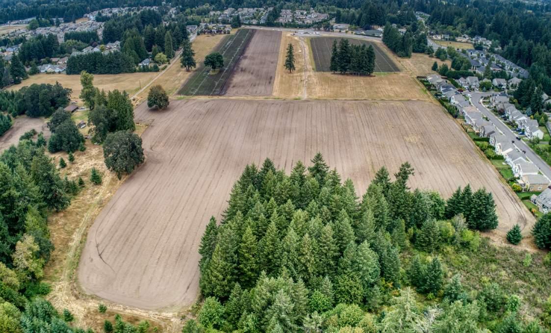
In 2018, the City of Olympia purchased this property from the Zahn family for a future community park. The Zahn family had owned the land for two generations, originally farming it themselves then leasing the fields to Spooner Berry Farm. A portion of the site consists of fields used for strawberry production, with a berry stand and gravel parking area located along Yelm Highway at the north end of the property. Much of the southern half of the site is forest and wetland. This master plan responds to the community's changing needs and growth and presents a design concept to guide future park development in a phased approach. The master plan incorporates active and passive recreational amenities, preservation and protection of critical areas, and public art integration. To meet a longstanding community need for dedicated rectangular fields in Olympia (see Parks, Arts & Recreation Plan, pp. 71-74), the first phase of this park will include rectangular fields. During the planning process, the Olympia School District (OSD) approached the Olympia Parks, Arts & Recreation Department (OPARD) about colocating a secondary school on the site. Olympia City Council approved the proposal, which will allow OSD and OPARD to share the costs of development and provide additional amenities for the community.

The design reflected in this master plan resulted from extensive community outreach by the design team and OPARD. The community truly shaped this project, and the design responds to their needs, hopes, dreams, and wishes. To the greatest extent possible, the design team incorporated the elements suggested by the community with the most support, as determined by public input. This report includes the public outreach process, with complete results in the appendix.

The total site area is approximately 86 acres, located along Yelm Highway in unincorporated Thurston County. The City of Olympia purchased 83 acres of the property in 2018 from the Zahn family, who had owned the land for two generations and were leasing the fields to Spooner Berry Farm. The Zahn family has a lifetime lease on 7 acres of the property.
Much of the northern portion of the site consists of fields used for strawberry production, with a berry stand and gravel parking area located along Yelm Highway at the north end of the property. Much of the southern half of the site is wooded, with a wetland in the southwest corner.
On March 22, 2022, the City Council considered and approved an official partnership proposal with the Olympia School District. The offer (see Appendix G) outlined the terms of the proposed colocation of a future secondary school campus on 22.91 acres of the site along the Yelm Highway frontage.

TOTAL
AREA: 86.25
SCHOOL CAMPUS 22.91 ACRES MAINTENANCE 3.24 ACRES FACILITY
PARK AREA 60.10 ACRES
PARK AREA: 60.10 ACRES
WETLAND 13.50 ACRES
WETLAND AND 10.50 ACRES STREAM BUFFER
LIFETIME LEASE 7 ACRES
DEVELOPABLE AREA (for intensive/active park uses) 29.10 ACRES
The master plan process included a robust public outreach process involving multiple types of outreach. The process centered around public meetings but also utilized a mailer and online surveys. Below is a diagram showing the components of the process and where they occurred from Site Analysis to Concept Design to Master Plan Development.
September2019
PublicMeetingNo.1:VisionandProgramming
February2020
PublicMeetingNo.2:SchematicDesignAlternatives
November2020
OnlinePublicSurveyNo.1OnlinePublicSurveyNo.2OnlinePublicSurveyNo.3

PublicMeetingNo.3:SchoolColocationDiscussion/Feedback
August2021
PublicMeetingNo.4:PreferredMasterPlan
OnlinePublicSurveyNo.4
August2022
PublicMeetingNo.5:ColocationMasterPlan


OnlinePublicSurveyNo.5
September 2022


The first public meeting was held on September 18, 2019, followed by an online survey available the same day, which closed on October 13, 2019. The survey asked residents about their vision for the future park, including which program activities they wished to see in the park design.


Sports fields were the most popular park feature desired by the community, followed by playgrounds and a trail system. For sports fields, soccer was by far the most popular, with 71% of the vote. For sport courts, the survey respondents expressed an interest in pickleball courts, basketball courts, and skate parks.
The survey also showed a high demand for park amenities including restrooms, picnic shelters, and barbecues. Respondents expressed interest in a dog park and preserving natural areas.
Top concerns from neighbors included traffic (vehicular, pedestrian, and bikes), parking, and noise pollution. Most survey participants lived within five miles of the park.


The second public meeting was held on February 27, 2020, followed by an online survey available the same day, which closed on March 22, 2020. Three concept plans were presented, and the public shared their preferences for their favorite site configuration.
Concept No.1
Concept
Concept No. 1: Four soccer fields cluster at the center of the park with a large restroom and concession stand between them. The great lawn along Yelm Highway is surrounded by active program elements: a playground, sprayground, pickleball and basketball courts, skating elements, and a community garden. This scheme proposes a fire station on Yelm Highway near the park entrance at Wiggins Road, and a maintenance facility near the lifetime lease area adjacent to the Hamptons neighborhood. A T-shaped parking area occupies the park's eastern edge with an entrance off Wiggins Road.

Concept No. 2: Four soccer fields cluster at the center of the park around a large warm-up space. Boardwalk paths traverse the wetland, and a dog park loops through the forest. The fire station and maintenance facility are both along Yelm Highway. A T-shaped parking area occupies the park's eastern edge with an entrance off Wiggins Road.


Concept
Preferred
full survey results, please refer to Appendix B.
Concept No. 3: Four soccer fields cluster at the center of the park, with a warm-up space between them, opening toward the parking area along the park's eastern edge. The great lawn along Yelm Highway is bordered by amenities including a playground, pickleball and basketball courts, and a dog park. The fire station is located on Yelm Highway at the corner of Hamptons Street. The maintenance facility is along the eastern property boundary. A boardwalk and nature loop cross the wetland, and a BMX skills park and loop weave through the forest.
An online public meeting held on November 16, 2020, discussed the possible colocation of a secondary school with the future community park. An online survey was opened on November 7, 2020, and closed on December 6, 2020. 109 visitors to the Engage Olympia website completed the survey.
Survey respondents were most concerned about the traffic and parking impacts to colocating the school and park. Respondents also expressed concern about potential loss of amenities. Most respondents felt it was important that there be efficiencies of shared infrastructure and recreational facilities if the school and park were colocated.

SURVEY QUESTION: How important are the opportunities and benefits of cost efficiencies of shared infrastructure and recreation facilities?
of
felt it was
to some degree
have
the
full survey results, please refer to Appendix B.
An online public meeting held on August 4, 2021, presented the preferred master plan. The design team also discussed how the design addressed community concerns including parking lot location, access that did not compromise the park neighbors, managing traffic flow, and lighting and noise.
An associated survey available on Engage Olympia also gathered feedback on the concept plan. The survey was open from August 5, 2021, through September 2, 2021, and received 62 responses. Most respondents lived within five miles of the park.
Survey respondents showed the most interest in loop paths and trails, followed by soccer fields. Responses also indicated community interest in protecting and enhancing wildlife habitat and providing opportunities for wildlife viewing. Responses indicated a preference for a nature-inspired play area, climbing, swinging, and sliding play features. Many community members also suggested providing shade structures adjacent to high-use areas, such as the fields and playground.
*For full survey results, please refer to Appendix B.

At their March 22, 2022, meeting, the City Council considered an official partnership proposal from the Olympia School District. The proposal outlined the terms of a proposed colocation at the Yelm Highway Community Park site.

The terms of the partnership include real estate transactions and property exchanges, a proposal outlining shared development costs at the Yelm Highway site, and proposed enhancements and expansions of the current Joint Use Agreement. The Council approved the terms proposed.
While future decisions related to the Joint Use Agreement, a Development Agreement, and Purchase and Sale Agreement will need future Council consideration, the Olympia School District and the Olympia Parks, Arts & Recreation Department began the process of updating the master plan for the property to reflect the colocation of the future secondary school and community park.
OPARD and OSD shared the colocation master plan at a public meeting and open house held at the Armory in Olympia on August 3, 2022. The design team, OPARD and OSD met with community members and discussed details of both the proposed master plan and first phase of improvements.
An online survey was made available on the Engage Olympia website on August 3, 2022 and closed on August 23, 2022. Survey respondents indicated that the activities they were most excited about in the future park are the loop path and trails, pickleball courts and wetland boardwalk. Of the shared facilities proposed by the school district, respondents were most excited about a community gym. The survey respondents also indicated a preference for sculptural or interactive public art in the park.

SURVEY QUESTION: What shared school facilities are you most interested in?
Entry Drive
Access
Parking (450 stalls)
Facility
Entry Plaza
Welcome Kiosk
Restrooms
Picnic Shelters Loop Path (accessible)
Soccer Fields
Sport Courts
Playground Sprayground Skate Park Dog Park Bike Skills Park Community Garden Climbing Structures
Gym
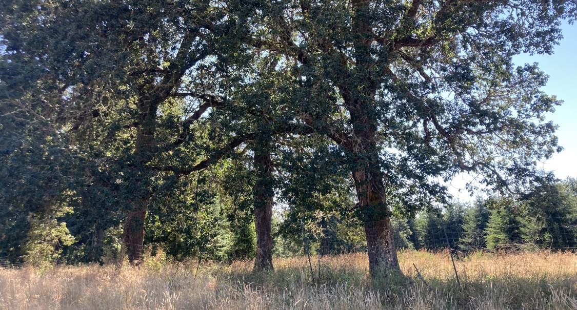
This master plan is about building on and celebrating existing site features: highlighting the agricultural character of the site, preserving large existing native oak trees, and protecting and improving habitat. This master plan seeks to enhance the existing site while providing much-needed recreation amenities for the community and looking toward the future.

The existing highlights of the park parcel include large open spaces dotted with mature native oak trees, as well as woodland and wetland habitats. The master plan proposes to maintain these features and provide additional recreational opportunities such as sports fields, passive and active recreation, gathering spaces, play opportunities, looped walkways and a wetland boardwalk. Ample proposed parking will accommodate the growing community and outdoor activity.
Plan above showing existing site features.


The park provides ample opportunities for active recreation and sports with three full-sized soccer fields, eight pickleball courts, two basketball courts, and several warm-up areas. A couple of playgrounds, a sprayground, a skate park, a bike skills park, and a dog park provide play opportunities for everyone.


In response to community feedback, the park will provide a number of sports fields and courts. These include the following:
• Three full-sized, lighted synthetic turf soccer fields
• Two basketball courts
• Eight pickleball courts
• Multi-Use Games Area
• Interactive sports arena
Additionally, the Olympia School District has offered to share sports amenities with the park per the colocation agreement. Community members will have access to numerous amenities outside of school hours on evenings and weekends. These include the following:

• One full-sized track and field
• Six tennis courts
• Community gym
Plan showing locations of all proposed sports fields.
In addition to the formal sports fields and courts, the master plan includes a Multi-Use Games Area, an interactive sports arena, and an interactive ball wall. These amenities allow for active, informal recreation play by individuals and smaller groups of players:


1. Multi-Use Games Area (MUGA): This synthetic turf area is fenced with built-in goal posts and designed to make dedicated room for popular sports such as football, basketball, hockey, volleyball, tennis, badminton, and handball. All supported activities are team sports, emphasizing the social element of creating space for people to hang out and be active.

2. Interactive sports arena: A compact outdoor sports field gives children plenty of contact with the ball. Since the game takes place in a small space, every player engages in the game. The sloping corners and the four goals on each side of the sports arena keep the game and every player in motion. This colorful multipurpose playground challenges players to run free and play tactically.
3. Interactive ball wall: The plan also proposes an interactive ball wall structure that brings people together and encourages them to participate in active competition with friends. This features games of differing levels to challenge all players, from beginner to advanced. 16 illuminated LED panels on the wall register ball contact using vibration sensors. Uses include sports such as soccer, tennis, and basketball, or training and improving agility, speed, and accuracy.


The master plan includes a community garden that will offer an opportunity to grow and access healthy food. The garden will have raised garden beds, including accessible plots, and a shed for tool storage. In addition to increasing access to fresh produce, the garden will create opportunities to build community among neighbors. The goal is to empower members of the community to design, build, and maintain spaces in the garden.


Art within the park is a way to express the unique qualities of the park and community. Opportunities for art abound in the paving, structures, boardwalk, park identification, and discovery pieces along the pathways. Emerging inspirations include the following:


• Native landscape: Northwest prairie, coniferous forest, vegetated wetlands
• Agriculture: a productive, domesticated, working landscape
• Seen from a distance, passing on the highway
• Surrounded by, connected to, buffered from the surrounding community
• Experienced from within
• Recreational programming
• Passive awesomeness and discovery
• Embracing scholarly pursuits (embracing future colocation with secondary school)
As phased park build-out moves forward, the artist’s role on the team will be to influence and inspire different outcomes that will be documented and completed as part of the design team’s work. This welcomes the possibility of the artist shaping the park into a catalyst for further art and creativity, be it permanent, temporary, ephemeral, or performance.
John Fleming, selected as the team artist, has spent 30 years developing a broad portfolio of art, architecture, and conceptual/environmental projects. Much of his work blurs the boundaries between all three. Living in the Northwest for the past 20 years has profoundly influenced how he works. He envisions that art may play a functional role in the park.
Art may be a beacon or a guide. It may be the special surface you walk on or the shape you can’t resist touching. Art may be part of the experience of moving along a path and what you see along the way. The artwork could be the path itself or what you discover at the end.


Site furnishings throughout the park will enhance park users’ experiences. The community expressed a desire for seating adjacent to high-use areas, such as the sports fields, courts, playground, and sprayground. This includes covered seating, protected from both sun and rain. When feasible, the design team strives to re-purpose wood from downed trees in the fabrication of site furnishings. Additionally, site furnishings can be integrated with art to provide playful, functional park infrastructure.


The architectural scope focuses on the collection of buildings and structures at the park entry and on the park maintenance facility. These structures include the following:
• Welcome kiosk
• Group picnic shelter
• Picnic shelters of various configurations and sizes
• Restrooms, storage, and food truck concession support
• Maintenance facility
Other than the maintenance facility, these structures establish an entry cluster that welcomes visitors to the park. This cluster sets the tone for the park’s “Prairie Farm” architectural design concept by evoking a sense of various farm buildings collected and assembled over time. The envisioned styles draw inspiration from the few simple farm stands that currently exist on the site, the large barn on the Zahn property, and contemporary agricultural structures.
Plan showing locations of all proposed architectural elements.

As the first structure seen when entering the park’s central promenade from the parking area, the welcome kiosk shall serve as a location for park information and event details. It includes a small room and welcome window that can accommodate staff for events such as sports tournaments or other occasions. The architectural design merges the concept of a farmhouse front porch with the idea of a farm stand to evoke a sense of welcome for visitors.

The group picnic shelter will provide the park with the largest protected gathering space. Intended to serve large groups, it could accommodate six to eight picnic tables. It could also possibly accommodate a small, informal stage and be used as a performance space. It will also meet the community’s desire for a large reservable area for groups and events.

As part of the aesthetics for this section of the park, the design drew inspiration from the concept of using a mix of materials found on area farm structures, such as weathered metal and wood. The barn building on the Zahn property and current berry stand structures exemplify this historic material use. By also introducing updated materials and forms, history will merge with a view toward the future, blending farm concept typologies with a modern, updated architectural design. Farm architecture, much like modern architecture, emphasizes form and function without decoration.

Two picnic shelters comprise the final two structures in the entry sequence. Each is different, providing a diversity of experiences for a variety of users. The picnic shelters offer opportunities for playful design, further evolving the “Prairie Farm” concept. Working with the same materials palette, these shelters can display different expressions of roof forms and wood framing. The concept designs include angular roofs and wood screen walls to define the spaces.
One shelter has a covered area of 20’x20’ which is sized to allow for two standard picnic tables. These could easily serve one larger group or be reserved for smaller groups.
The second picnic shelter has a covered area of about 10’x18’ that partially protects a long communal table with alternating benches on either side and space for wheelchair access or strollers. This location can serve as overflow space from the concession area and as a place to sit while enjoying a concession snack, waiting for someone using the restroom, or chatting while the kids play on the adjacent lawn.
The main restroom building is a larger structure that faces the group picnic shelter and frames a gateway into the park. The restroom building and the group shelter share a similar scale and appearance. This facility accommodates 11 water closets, two of which are family rooms with their own sink and changing tables. In addition, this building will have a large storage area for park use that includes a space intended to serve multiple food trucks on site with both a three-compartment and hand-washing sink.

In approaching restroom design, the design team advocates for an inclusive design that supports everyone. The Yelm Highway Community Park is a great opportunity to implement this approach. One basic way to accomplish this goal is simply to provide single-user, non-gendered restroom facilities.

Beyond providing single-user restrooms, the design could rethink the formula to provide safe, equitable, and fully accessible restrooms that consider families, genders, abilities, ages, and religions. One proposal is to organize restrooms by privacy zones instead of gender or family usage designations. Additionally, a “farm” aesthetic could consider ideas like exterior sinks. Water closets would be private and secured, entered directly from a common access area, and communal sinks could be used without entering an enclosed, gendered bathroom.
Considerations from the COVID-19 pandemic will also affect design and sanitation requirements now and in the future. Everything from no-touch features to hand dryers vs. paper towels are factors to consider carefully with restroom design. Additionally, increased distancing and circulation routes should avoid congested bottleneck spaces at entries and exits.
For the full build-out of the park, the design team anticipates the need for a second, smaller restroom adjacent to the sprayground and playground. Assuming the occupancy of the park is around 780 park users (based on an average of two people per car, with 390 parking stalls), the park would need 16 water closets (WAC 510-50-900, Chapter 29 - Plumbing Systems, Table 2901.1 for Minimum Number of Required Plumbing Fixtures, requirements for Occupancy A-5).

A final programming effort will be coordinated with OPARD to ensure that the maintenance facility meets the needs of the park system. The design assumes that this maintenance facility will include staff offices, a garage for storage and workshop spaces, and a yard area for various parks and maintenance bulk materials. For the purposes of facilitating the different functions and types of occupation, the design proposes a separate office building and a separate garage/shop building.
The design assumes that both buildings will be pre-manufactured metal type buildings. The garage/shop building will be a larger, open plan structure with multiple garage doors, a restroom, and covered outdoor area. The office building will be a smaller structure housing the required number of staff offices, a meeting room, and staff amenity spaces such as restrooms and a lunch/break room.
The proposed design incorporates the following elements for the building and general maintenance facility:
• Maintenance yard: circulation, materialsstorage, vehicle wash, site drainage,oil/water separator
• Garage/shop (pre-engineered metalbuilding)
o Three to four garage doors large enough for park maintenance vehicles


o Two pairs of man doors
o Unisex restroom
o Insulation to meet code
• Offices (pre-engineered metal building)
o Entry vestibule/reception
o Staff offices
o Meeting room
o Lunch/break room
o Restrooms
•
o Hose bibbs
o Area heaters for freeze protection; no A/C
o Ventilation as required by code
• Electrical
o LED lighting
o Charging stations for park vehicles as well as general outlets
o Connections for mechanical equipment
o Verify if garage doors will be powered or manually operated

Based on a preliminary traffic study, it is anticipated that Wiggins Road will need to be widened to accommodate vehicular access into the site as well as the potential for a straight/right turn lane and a left turn lane onto Yelm Highway. This change in channelization striping on the south side of Wiggins Road and Yelm Highway may also require modifications to the turn lane channelization on the north side of Yelm Highway. This will need further coordination as the design progresses.
At this time, standard asphalt and concrete pavement are proposed for use at the site. Pervious pavements could be considered for the pedestrian walkways to help with stormwater mitigation. However, pervious pavements are more expensive, difficult to install, and require more maintenance than traditional pavement surfaces. The design team would not recommend the use of pervious pavements for the maintenance facility or parking lot areas.
Plan shows access routes (pedestrian and vehicular) through the site. Solid lines indicate vehicular access.

A number of new and improved sidewalks surrounding the site will provide access to the new community park campus. The trail system consists of a primary loop path approximately half a mile in length. This connects to a secondary trail system that connects numerous site amenities, such as the playground, sprayground, skate park, dog park, bike skills area, and wetland. Through the wetland, this path transitions to an elevated boardwalk, providing an immersive nature experience. The sidewalks and trails will provide approximately 2.2 miles of circulation pathways throughout the site. A potential future connection to the Chehalis Western Trail has been identified on the south boundary of the park property.


Character images representative of design intent (top). Plan showing trail network and approximate distances (bottom).

The master plan proposes 390 total parking stalls, including eight electrical vehicle stalls and ten accessible stalls (two of which are van accessible). Considerations for parking locations included the following:
• Vehicular access points into the site
• Pedestrian safety
• Proximity to amenities
• Efficiency in layout and access
In order to minimize impacts to park neighbors, the plan proposes an 80' minimum width buffer with a 6' berm, planted to provide screening and privacy.
Approximately 490 additional parking stalls will be included on the secondary school campus. This shared parking will be available to the public outside of school hours in the evenings and on weekends.
Shared Parking (490 stalls)
Parking (70 stalls)
Parking (390 stalls)
Plan showing vehicular access into the park and parking lots on park and school campus.


A vegetation management plan can provide guidelines for future improvements, as well as for maintenance and operation standards. It can also serve as a guide for community-based stewardship activities within the park's natural areas.


In a large park setting, issues such as recreation, safety, conservation and maintenance are intertwined. The following vegetation management goals focus on protecting and enhancing the vegetation resources of the park. The overall goals and objectives for vegetation management are summarized below:
• Preserve and enhance an uninterrupted landscape and ecological continuity from the wetland into the Park.
• Enhance the wetland and buffer through invasive species removal and native planting.
• Promote native character in natural areas.
• Restore native forest stands to enhance natural forest processes. This includes selective thinning to manage fuel build up and fire risk.
• Coordinate with adjacent landowners to identify appropriate plantings for the Chambers Ditch buffer to maintain hydrologic function.
• Identify selective thinning of standing dead wood in wetland to minimize fire risk.

•
Conserve soil and water quality.
• Protect and enhance wildlife habitat.
• Take advantage of the area's great abundance and variety of views: wetlands, woodlands, and distant mountains.
•
Design planting palettes to create a diversity of habitats to support pollinators and wildlife, prioritizing the use of native and climate adapted species.
• Buffer adjacent land uses.
• Ensure public safety.
• Gain community appreciation for the landscape.
Site images of existing vegetation.
Preserve existing tree groves
Enhance wetland and buffer through invasive species removal and native planting
Selective thinning in forest stands to manage fire risk

Manage vegetation in Chambers Ditch buffer to maintain hydrologic function

Critical areas associated with the site include a regulated wetland and associated buffer, a regulated stream and associated buffer, oak tree habitat, and Endangered Species Act-listed Mazama pocket gophers (MPG) and their habitat (see Appendix D for Critical Areas Report). Impacts from the proposed project will require local, state, and/or federal permits and approvals.

Permits and approvals anticipated for the project include those related to impacts on critical areas including wetland, wetland and stream buffer, and MPG habitat. Since the project is still in the planning phase and will be implemented in phases over an unknown period of time, it may only require some of the permits and approvals listed in the permit matrix (Appendix C). If code requirements change then additional permits not listed may be required in the future. As the project is also located in an Urban Growth Area that may be annexed into Olympia, different phases of the project could be permitted in different jurisdictions over time. Accordingly, the information provided in the permit matrix in Appendix C is for both Thurston County and City of Olympia environmental permit processes. At this time, the city is considering pursuit of an interlocal agreement with Thurston County to retain permitting authority with the county; this would facilitate a more streamlined permitting process and avoid mid-project changes in applicable codes and procedures.
In addition to the permits and approval requirements listed in Appendix C, mitigation will be required for impacts to wetland, wetland and stream buffers, and MPG habitat. Impacts to buffers require compensatory mitigation at a 1:1 ratio, which will be mitigated onsite through enhancing existing degraded buffers. Impacts to MPG habitat will require mitigation through coverage under a Habitat Conservation Plan (HCP). Coverage under an HCP will occur either through the acquisition of a Certificate of Inclusion to Thurston County’s Incidental Take Permit under its HCP or through the development of an individual HCP by the city. The type of HCP will be dependent on who has permitting authority for each phase of the project (city or county). MPG mitigation will be acquired through a mitigation bank and/or through the acquisition of land for conservation purposes. The amount and cost of mitigation are calculated based on the total amount of impacts, type of habitat, the subspecies of MPG on the property, and the cost of land, and therefore will vary depending on when mitigation is acquired (see Appendix E). The only direct wetland impact being considered relates to potential installation of a raised boardwalk through primarily degraded areas of the existing wetland. The appropriate mitigation ratios and compensatory mitigation strategy would be determined at a later date but is likely to include enhancement of the wetland.
Site photos depicting the regulated wetland (left), and Mazama pocket gopher mounds (right).The City of Olympia will be seeking a state grant for capital improvements from the Washington State Recreation and Conservation Office (RCO), which will trigger compliance with Governor’s Executive Order 21-021 (EO 21-02). EO 21-02 requires state agencies implementing or assisting capital projects to consider how proposed projects may impact significant cultural and historic places. Under EO 2102 an agency must coordinate with the Department of Archaeology and Historic Preservation (DAHP) and affected Tribes. If cultural resources are identified during review, the agency is required to develop appropriate mitigation strategies and take reasonable action to avoid, minimize, or mitigate adverse effects to cultural resources.
The City of Olympia purchased the land to be used for the Yelm Highway Community Park in 2018 from the Zahn Family, who had farmed the land since the 1930s. The project archaeologist, WillametteCRA, has conducted a cultural resources assessment for the project (see Appendix F). While no subsurface materials were encountered, a collapsed, historic-period brood house, part of Zahn Place, was recorded as archaeological site 45TN530. While the brood house is directly associated with the farming tradition of the area and was part of one of the last large farm operations in the vicinity (Criterion A), it does not represent a significant contribution to the history of farming in the region. The Cameron and Zahn families, while longstanding Olympia-area farmers, do not fulfill the requirements for NRHP significance under Criterion B, particularly related to their farming. Further, even when still standing, the vernacular character of the structure is not significant (Criterion C). Most historic information about the brood house is gained from the photographs and maps that are available rather than from the collapsed structure (Criterion D). Further, as a structure in ruins, the brood house does not have integrity of design, workmanship, feeling, or association. For these reasons, the site as currently documented is recommended not eligible for listing in the NRHP. However, the extent of Zahn Place has not been fully documented, since it is currently encumbered by the Zahn's life estate. It is anticipated that future subsurface investigations within the boundaries of Zahn Place, particularly near the former locations of the Dunham or Cameron homes, could uncover cultural materials that may alter this recommendation.

Based on the results of this assessment, WillametteCRA recommends no additional archaeological work. An Inadvertent Discovery Plan should be developed for use during Phase 1 project construction.

Temporary erosion and sediment control measures will be required during construction to control soil erosion and sediment transport from the site. These measures include installing stabilized construction access driveways consisting of filter fabric and quarry spalls, which will help provide stabilization of soils for trucks entering and exiting the site as well as reduce soil track out onto public roadways. Wheel wash facilities may also be required to help reduce sediment track out from the site. Catch basin filter inserts will be installed in existing catch basins within Wiggins Road and Yelm Highway adjacent to the site to protect the existing storm drain system from sediment contamination. Silt fencing will also be installed around the southern perimeter of the site adjacent to the areas of work as well as around the existing infiltration pond at the south end of Wiggins Road. This will help prevent sediment from flowing off the site or into the existing infiltration pond. Depending on the time of year when work starts or the condition of the site at the start of the rainy season, temporary interceptor swales to collect and transport construction stormwater to sediment traps/ponds may also be required.
The proposed site grading will slope from north to south, as in the existing conditions, but with a more constant slope, especially within the field areas. Fields will be graded at a slope of approximately 0.5%. The parking lot and other hard surfaces will generally be graded at a minimum 1.0% slope to ensure that stormwater at the surface can adequately flow to the drainage collection facilities. All hard-surface walkways, ADA parking stalls, and access aisles will be graded to meet ADA slope requirements. Berms with dense landscape planting and trees will create buffers from the park to the adjacent residential neighborhood to the east. In addition, mounded landforms will also be a signature element used around the site. Grading for these features will be coordinated with the landscape architect.
The City of Olympia has adopted a Drainage Design and Erosion Control Manual, dated December 2016. This manual is based on the 2012 Department of Ecology Stormwater Management Manual for Western Washington that was amended in 2014. The initial geotechnical investigations indicate that native soils at the site are highly infiltrative with an anticipated infiltration rate of 15 inches per hour based on a grain size analysis. This will need to be confirmed by onsite infiltration testing as the project progresses. A design infiltration rate of 7.5 inches per hour was used to provide preliminary sizing for the proposed drainage facilities. The approach for handling stormwater at the site will be to utilize infiltration and dispersion facilities to mitigate all stormwater onsite, as the public storm drain facilities are located in Yelm Highway and Wiggins Road, which are upstream of the project site and would require pumping for site discharge. With the widening of Wiggins Road to provide vehicular access into the site, the existing roadside swale and infiltration pond will need to be modified to accommodate these changes. A roadside swale on the west side of Wiggins Road is still being proposed to provide stormwater conveyance as well as sediment removal and limited infiltration. The swale will now discharge to the location where there was an existing infiltration pond. This pond will be modified to become an infiltrating bioretention area, which will provide water quality treatment and flow control (infiltration) for the west half of Wiggins Road and a portion of the access road into the site.
Stormwater runoff from the maintenance building site, as well as the site access road and parking areas, will be mitigated via an infiltrating bioretention area located east of the parking lot. Runoff from the maintenance building site and access road will be collected in roof drains and catch basins and piped to the bioretention facility. The roundabout will sheet flow into a narrow infiltrating bioretention area around the inside perimeter of the drive that has a piped overflow into the larger infiltrating bioretention area associated with the parking lot. The parking lot has been graded to sheet flow toward the center landscape areas, which will be flush with the adjacent pavement grade so stormwater runoff can enter the landscape island that will include an infiltrating bioretention strip with an overflow drain piped to the larger bioretention area northeast of the parking lot. As site buildout continues, the same approach will be used for the parking lot expansion and will include a second infiltrating bioretention area at the east side. It is anticipated that the parking lot furthest south will be graded to slope from south to north. This is consistent with the existing grades in this localized area.
The synthetic turf fields are anticipated to mitigate their storm drainage within the field area footprint. They will include an under-drain system that will allow infiltration into the native soils below. In addition, a larger infiltration basin can be constructed below grade at the south ends of the fields to provide a larger storage area if needed. Pipe stubs will be provided to the fields to convey any overflows to a secondary facility. For the Phase 1 field, the secondary facility is anticipated to be an infiltrating dispersion trench. For the fields constructed in the future phases, it is anticipated that the overflow piping will be routed to an infiltrating dispersion trench located at the south end of the improvement area to infiltrate/disperse into the native vegetation to remain at the south end of the site.
The outlying restrooms and picnic shelters anticipated to be constructed during full build-out of the park facility will also require drainage facilities. Since roof runoff is considered clean water, runoff from the downspouts can be piped into a small catch basin with a sump to collect any sediment or debris, prior to discharging these roof areas into a drywell facility adjacent to the structure. In areas where these facilities are close to other below-grade drainage piping, an overflow pipe could be extended from the drywells to connect into the adjacent facility as a backup.
The playground areas are anticipated to infiltrate stormwater below pervious playground surfacing (poured-in-place rubber safety surfacing) into a gravel infiltration basin. An overflow from the infiltration basin can also be provided as a backup connected into a secondary infiltration/dispersion system.


The skate park will need to be equipped with area drains in the bowls and low spots to collect stormwater runoff. It is anticipated that this flow will be conveyed to an infiltration/dispersion trench located at the south edge of the park development. Any drainage associated with the sprayground could also be connected into the piped conveyance from the skate park area.

Based on the anticipated fire flow needs of the maintenance facility and park structures, it is assumed that the public water system will need to be looped through the site from the dead-end of Wiggins Road to the end of the public water system in Hamptons Street, located to the northwest of the park facility. The portion of the looped system that extends up to Hamptons Street runs along the west property line so as not to affect the future development of the school property to the north of the park. A tee stub-out toward the school site could be added to this line as it is also anticipated that the school will need a water loop through their site to provide adequate fire flow coverage. The looped water system through the site will be part of the city’s public water system and may require an easement depending on the city’s policy for public water systems through park facilities.
It is anticipated that at least an 8-inch diameter pipe will be required to be looped through the site. A new fire hydrant will be installed to provide fire coverage to the maintenance facility building. It is also assumed that the maintenance facility will require a fire sprinkler system; therefore, a new fire service with a fire department connection will be required to serve this building. It is anticipated that the backflow device for the fire sprinkler system can be housed inside the sprinkler riser room in the building and not have to be located in a large, below-grade vault on the site. The domestic water service and meter serving the maintenance facility would be connected to this new looped water system off the access road into the park.
A fire hydrant off the looped water system is anticipated to be required at each park restroom building and at the maintenance facility. At this time, fire hydrants are not included to serve each picnic shelter, but this will need confirmation with the city. Currently, a new domestic water service, meter, and backflow prevention device are anticipated to be included for each restroom building and maintenance facility. Currently, water services to hose bibs at the picnic shelters are shown coming off the service to the adjacent restroom, so a separate water meter and backflow prevention device would not be required for each picnic shelter. A water service line to multiple hose bibs serving the community garden will be provided.
Sewer services will be required for the maintenance and restroom buildings at the site. It is assumed that any standalone drinking fountains, not discharging into building plumbing, will discharge to a drywell facility. The closest public sewer facilities are located in Yelm Highway and Wiggins Road, which are both uphill from the proposed park facilities. It appears that the maintenance facility building and sewer system will be able to gravity discharge into the adjacent public sewer, but the remainder of the new park facilities will need to be pumped up to the public system in Wiggins Road. A gravity sewer system is shown from the main restrooms to a sanitary sewer manhole on the east side of the restroom building. It is assumed that a duplex pump system would be located in this manhole to pump flows from the site up to a new manhole located at the maintenance building facility. This manhole would then gravity drain out to the existing manhole at the intersection of Wiggins Road and the entrance to the Country Club Villas. The invert elevations of the manhole in Wiggins Road need to be confirmed to ensure that gravity flow is achievable from the maintenance facility site.
A separate pump system at the westerly restroom building would also be required. Depending on the building layout, anticipated fixture count, and flows, a more residential-scale interior pump or an exterior grinder pump in a small basin may be feasible and would be pumped to a sanitary sewer manhole outside of the westerly restroom building. The westerly restroom building as well as the sprayground discharge would gravity flow to this manhole. This manhole would have a duplex pump system that would discharge to a sewer force main that would be routed to the manhole adjacent to the main restroom building near the center of the site, and then would be pumped up to the maintenance facility manhole.


Site lighting consists of three areas: parking lot, walking path, and entry drive. The parking lot will be provided with four 30’ poles with two full-cutoff LED fixtures each to achieve 1–1.5 footcandle average throughout parking lot area. The full-cutoff LED diodes are directionally controlled with internal glare shielding. Photometrics indicate 0.0 footcandles at eastern property line. The entry drive will be provided with similarly styled fixtures as the parking lot, with the exception of single fixture per pole. The walking path will be provided with a 16’ column style LED fixture evenly spaced (110’-120’) along the walking path. Each of the walking path column light fixtures will be provided with a 120V, 20A, GFCI, duplex receptacle with “in-use” weatherproof cover mounted at 12’-0” AFG.

Power utilities will be served from an existing PSE pole along Yelm Highway and undergrounded through the site. PSE’s primary (12,470 volt) feeder(s) will be routed through a series of pull vaults per PSE standards and requirements through the site and will require PSE easements. The maintenance building will be provided with a 208V, 3ph transformer and 400A electrical service. A second PSE transformer will be located adjacent to the restroom building with an 800A, 120/208V, 3ph service, which will serve ballfield lighting, parking lot, concessions, restrooms, and pathway lighting. The future school building will be provided with a separate transformer and electrical service based on the school design.
The first phase of park development will establish site infrastructure for future phases and will include one full-sized rectangular synthetic turf field with lighting, restrooms, parking, a maintenance facility, a perimeter loop trail, a playground, sport courts, interactive games, a dog park, and a mountain bike skills area. As a result of the colocation agreement, Olympia School District (OSD) will share the cost of site infrastructure and required mitigation. OSD will also fund the construction of a full-sized track and field and adjacent parking area on the future school's campus to be built in tandem with the park's Phase 1 development. It is anticipated that construction of Phase 1 will be completed in 2025.

Maintenance Office Building 1,386,443
Maintenance Shop Building 2,259,993
Maintenance Building Sitework 1,023,885
Full-sized Synthetic Turf Field with Lighting 2,578,185
Restroom Building 1,303,911
Picnic Shelter 98,829
Parking Lot 927,441
Access Road (30%) 287,441
Site Work (Site Preparation, Grading, and Paths) 6,664,122
Sport Courts (2 basketball, 6 pickleball, 1 MUGA) 760,002
Interactive Games 100,000
Playground (5,000 SF) 555,898
Dog Park (0.75 acre) 386,698
Mountain Bike Skills Area (1 acre) 560,103
1% for the Arts 188,930
Gopher Mitigation 482,000
Total
Access Road (70%) 680,695
Wetland Mitigation, Sewer Lift 800,460
Gopher Mitigation 650,000
Total
Estimating/Design Contingency (15%)
General Conditions (12.25%)
Contractor Overhead (7.25%)
Escalation (4%)
This estimate provides a rough order of magnitude cost for the full build out of park amenity items not implemented in Phase 1. Each program element can be built as funding is made available.

Full-sized Synthetic Turf Field with Lighting #2 2,600,000
Full-sized Synthetic Turf Field with Lighting #3 2,600,000
Restroom Building #2 (Prefabricated, 4-6 stalls) 500,000
Playground #2 (10,000 SF) 1,000,000
Sprayground (3,200 SF) 1,000,000
Skate Park (10,000 SF) 800,000
Wetland Boardwalk 3,000,000
Parking Lot Expansion 1,400,000
Entry Kiosk 300,000
Picnic Shelters at Entry Plaza 520,000
Picnic Shelters (4, Prefabricated) 200,000
Community Garden 200,000
Climbing Structures 500,000
1% for the Arts 146,200
Estimating/Design Contingency (15%)
General Conditions (12.25%)
Contractor Overhead (7.25%)
Escalation (4%)
Washington State Sales Tax Frontage Improvements
A. Public Survey Results
C. Critical Areas Report
E. Cultural Resources Assessment
F. Traffic Analysis
G. Proposed Partnership with Olympia School District for Secondary School Colocation
