
prepared by City of Orinda Planning Department 22 Orinda Way Orinda, California 94563
Contact: Winnie Mui, Associate Planner
Draft Environmental Impact Report

September 2022
Plan Orinda
prepared with the assistance of Rincon Consultants, Inc. 449 15th Street, Suite 303 Oakland, California 94612

Plan Orinda
prepared with the assistance of Rincon Consultants, Inc. 449 15th Street, Suite 303 Oakland, California 94612
September 2022
Contact: Winnie Mui, Associate Planner
Draft Environmental Impact Report
prepared by City of Orinda Planning Department 22 Orinda Way Orinda, California 94563

This report prepared on 50% recycled paper with 50% post consumer content.
Table of Contents Draft Environmental Impact Report i Table of Contents Acronyms and Abbreviations................................................................................................................. ix Executive Summary ES-1 Project Synopsis ES-1 Project Objectives ES-2 Housing Element Update ES-2 Downtown Precise Plan ES-2 Alternatives ................................................................................................................................ES-2 Areas of Known Controversy .....................................................................................................ES-4 Issues to be Resolved .................................................................................................................ES-4 Issues Not Studied in Detail in the EIR .......................................................................................ES-4 Summary of Impacts and Mitigation Measures ........................................................................ES-4 1 Introduction 1-1 1.1 Purpose and Legal Authority 1-1 1.2 Environmental Impact Report Background 1-1 1.3 Scope and Content 1-2 1.4 Lead, Responsible, and Trustee Agencies 1-12 1.5 Environmental Review Process 1-12 2 Project Description ..................................................................................................................... 2-1 2.1 Project Title and Brief Description .................................................................................. 2-1 2.2 Lead Agency Name, Address and Contact Person .......................................................... 2-1 2.3 Project Location .............................................................................................................. 2-2 2.4 Project Characteristics .................................................................................................... 2-2 2.4.1 Housing Element Update 2-5 2.4.2 Downtown Precise Plan 2-8 2.4.3 Population Projections 2-17 2.4.4 Proposed Zoning Changes 2-17 2.4.5 Proposed Height Changes 2-17 2.4.6 Safety Element Update 2-18 2.5 Required Discretionary Actions 2-21 3 Environmental Setting ................................................................................................................ 3-1 3.1 Regional Setting and Surrounding Land Uses ................................................................. 3-1 3.2 Existing Land Uses and Zoning ........................................................................................ 3-1 3.2.1 Housing Element Update ................................................................................ 3-1 3.2.2 Downtown Precise Plan Area ......................................................................... 3-4 3.3 Cumulative Development 3-8 4 Environmental Impact Analysis .................................................................................................. 4-1 4.1 Aesthetics ..................................................................................................................... 4.1-1 4.1.1 Setting .......................................................................................................... 4.1-1 4.1.2 Regulatory Setting ....................................................................................... 4.1-8 4.1.3 Impact Analysis .......................................................................................... 4.1 12 4.1.4 Cumulative Impacts ................................................................................... 4.1 21
4.3 Biological Resources 4.3-1 4.3.1 Environmental Setting 4.3-1 4.3.2 Regulatory Setting 4.3 13 4.3.3 Impact Analysis 4.3 18 4.3.4 Cumulative Impacts 4.3 31
.......................................................................................
...................................................................................
........................................................................................
.................................................................
..........................................................................................
4.4 Cultural Resources 4.4-1 4.4.1 Environmental Setting 4.4-1 4.4.2 Existing Conditions....................................................................................... 4.4-5 4.4.3 Regulatory Setting 4.4 11 4.4.4 Impact Analysis 4.4 15 4.4.5 Cumulative Impacts 4.4 20
........................................................................................................
.......................................................................................
4.7 Land Use and Planning 4.7-1 4.7.1 Environmental Setting 4.7-1 4.7.2 Regulatory Setting 4.7-3 4.7.3 Impact Analysis 4.7-6 4.7.4 Cumulative Impacts 4.7 11 4.8 Noise 4.8-1 4.8.1 Project Noise Setting 4.8-3 4.8.2 Regulatory Setting 4.8-5 4.8.3 Impact Analysis 4.8-7 4.8.4 Cumulative Impacts 4.8 18 4.9 Population and Housing 4.9-1 4.9.1 Setting 4.9-1 4.9.2 Regulatory Setting 4.9-2 4.9.3 Impact Analysis 4.9-5 4.9.4 Cumulative Impacts 4.9-8 4.10 Public Services and Recreation 4.10-1 4.10.1 Setting 4.10-1 4.10.2 Regulatory Setting 4.10-5 4.10.3 Impact Analysis 4.10-9 4.10.4 Cumulative Impacts 4.10 17
.........................................................................................................
...................................................................................
4.2 Air Quality and Greenhouse Gas Emissions 4.2-1 4.2.1 Air Quality Setting 4.2-1 4.2.2 Greenhouse Gas Setting 4.2-5 4.2.3 Regulatory Setting 4.2-6 4.2.4 Impact Analysis 4.2 11 4.2.5 Cumulative Impacts 4.2 30
4.6 Hazards and Hazardous Materials 4.6-1 4.6.1 Setting 4.6-1 4.6.2 Regulatory Setting 4.6-9 4.6.3 Impact Analysis 4.6 15 4.6.4 Cumulative Impacts 4.6 24
...............................................................................................
.....................................................................................
..............................................................................
...............................................................................
.......................................................................................
City of Orinda Plan Orinda ii
..................................................................................
4.5 Geology and Soils 4.5-1 4.5.1 Setting 4.5-1 4.5.2 Regulatory Setting 4.5-9 4.5.3 Impact Analysis 4.5 12 4.5.4 Cumulative Impacts 4.5 24
.......................................................................................
............................................................................................
..........................................................................................................
..........................................................................................................
...................................................................................
............................................................................................
.....................................................................................
..........................................................................................................
..........................................................................................
Growth ......................................................................................... 5 1 5.1.2 Economic Growth ........................................................................................... 5 2 5.1.3 Removal of
4.12 Tribal Cultural Resources 4.12 1 4.12.1 Setting 4.12 1 4.12.2 Regulatory Setting 4.12 1 4.12.3 Impact Analysis 4.12 3 4.12.4 Cumulative Impacts 4.12 6
........................................................................................................
.................................................................................
...........................................................................................................
Table of Contents Draft Environmental Impact Report iii
...................................................................................
.................................................................................
4.15 Effects Found Not to be Significant............................................................................ 4.15 1 4.15.1 Agriculture and Forestry Resources 4.15 1 4.15.2 Energy 4.15 2 4.15.3 Hydrology and Water Quality 4.15 3 4.15.4 Mineral Resources 4.15 6 Population Obstacles
..........................................................
........................................................................................................
........................................................................................
4.13 Utilities and Service Systems 4.13 1 4.13.1 Setting 4.13 1 4.13.2 Regulatory Setting 4.13 4 4.13.3 Impact Analysis 4.13 11 4.13.4 Cumulative Impacts 4.13 20 4.14 Wildfire 4.14 1 4.14.1 Setting 4.14 1 4.14.2 Regulatory Setting 4.14 6 4.14.3 Impact Analysis 4.14 12 4.14.4 Cumulative Impacts 4.14 20
........................................................................................................
.....................................................................................
........................................................................................
....................................................................
.....................................................................................
to Growth .................................................................... 5 2 5.2 Irreversible Environmental Effects .................................................................................. 5 2 6 Alternatives 6 1 6.1 Alternative 1: No Project Alternative 6 2 6.1.1 Description 6 2 6.1.2 Impact Analysis 6 3 6.2 Alternative 2: DPP Plus BART Sites 6 15 6.2.1 Description 6 15 6.2.2 Impact Analysis 6 18 6.3 Alternative 3: No DPP 6 45 6.3.1 Description 6 45 6.3.2 Impact Analysis ............................................................................................. 6 48 6.4 Alternatives Considered but Rejected .......................................................................... 6 70 6.5 Environmentally Superior Alternative .......................................................................... 6 70 7 References 7 1 7.1 Bibliography 7 1 7.2 List of Preparers 7 14
4.11 Transportation 4.11 1 4.11.1 Setting 4.11 1 4.11.2 Regulatory Setting 4.11 10 4.11.3 Impact Analysis 4.11 14 4.11.4 Cumulative Impacts 4.11 26
......................................................................................................................
5 Other CEQA Required Discussions 5 1 5.1 Growth Inducement 5 1 5.1.1
Table 2 1 RHNA Allocation and Percentage of Income Distribution for Orinda ...................... 2 7
Table 4.2 3 Operational and Construction Related Criteria Air Pollutant and Precursor Screening Level Project Sizes 4.2 12
Table 4.2 5 Project Consistency with Applicable 2017 Plan Control Measures ..................... 4.2 19
..................................................
Table 4.8 1 AASHTO Maximum Vibration Levels for Preventing Damage 4.8 3
Table 4.7 1 Plan Orinda Consistency with Plan Bay Area 2050 Goals 4.7 8
Table 2 4 DPP Housing Element Sites: Proposed Zoning Changes and Development Assumptions 2 13
...............................
iv
Table ES 1 Summary of Environmental Impacts, Mitigation Measures, and Residual Impacts 5
.........................................................................
......................................................................................................ES
Table 4.1 1 Non Transit Priority Area DPP Housing Element Sites 4.1 16
Table 4.2 7 Project Operational GHG Emissions 4.2 27
.......................................................................
Table 1 1 NOP Comments and EIR Response 1 3
Table 4.4 4 Inventory of Plan Orinda Sites 4.4 8
.........................................................................................................
Table 4.2 6 Increase in Population Compared to VMT Under Project ................................... 4.2 22
Table 3 1 Housing Element Sites Current Land Use and Zoning Outside of the DPP Area 3 2
...............................................................................
Table 4.4 1 Inventory of Housing Element Update Housing Element Sites ............................. 4.4 5
Table 4.4 3 Known Historical Resources in the DPP Plan Area 4.4 7
Table 4.2 9 City of Orinda General Plan Consistency for GHG Emissions .............................. 4.2 29
Table 4.5 2 Geologic Units in City of Orinda and Paleontological Sensitivity 4.5 22
Table 2 3 Housing Element Sites: Proposed Zoning Changes and Development Assumptions Outside the DPP Area 2 9
Table 4.2 2 Ambient Air Quality at Nearest Monitoring Station 4.2 5
Table 4.6 1 Hazardous Material Sites within the DPP Plan Area 4.6 5
Table 4.4 2 Cultural Resources Previously Recorded within 0.25 Mile of the DPP Area 4.4 6
Table 4.2 8 Project Consistency with Plan Bay Area 2050 4.2 28
.............................................
Table 4.7 2 Plan Orinda Consistency with the General Plan 4.7 10
Table 2 2 City of Orinda Regional Housing Needs Allocation 2 7
Table 4.2 1 Federal and State Ambient Air Quality Standards and Attainment Status ........... 4.2 3
.........................................
City of Orinda Plan Orinda
...................................................
Table 3 2 DPP Residential Sites Current Land Use and Zoning 3 6
Table 4.2 4 BAAQMD Criteria Air Pollutant Significance Thresholds 4.2 13
Table 4.6 2 Cleanup Sites in the DPP Plan Area 4.6 5
...........................................................................
Table 4.6 3 Hazardous Material Sites within 0.25 mile of a School 4.6 8
..............................................
....................................................................................
Table 3 3 DPP Downtown Commercial and Downtown Office Sites Current Land Use and Zoning 3 7
Table 4.5 1 Housing Element Sites Within a Landslide Zone 4.5 6
Tables
................................................
Table 3 4 Cumulative Projects List 3 8
Table 4.13 1 EBMUD Water Supply and Demand Projections 4.13 1
....................................................................
Figure 2 3 Proposed Housing Element Sites Outside of the DPP Area 2 6
............................................................................
......................................
Figure 2 4 DPP Sites West of State Route 24........................................................................... 2 11
Table 6 8 Increase in Population Compared to VMT Under Alternative 3 6 50
.....................................................................................................
Table 4.10 1 Orinda Fire Protection District Staffing by Divisions 4.10 1
Table 6 9 Operational GHG Emissions for Alternative 3 6 51
Table 4.9 1 2021 Population, Households, and Housing Unit Estimates 4.9 1
Table 6 4 Operational GHG Emissions for Alternative 2 6 24
Figure 1 1 Environmental Review Process 1 14
Table 6 1 Comparison of Project Alternatives’ Buildout Characteristics 6 2
Table 6 6 VMT Summary: 2040 With Alternative 2 6 38
..............................................................................
.................................
Figures
Table 6 5 VMT Summary: 2020 With Alternative 2 6 38
...............................................................
Table 6 12 Mitigation Measure Comparison of Project Alternatives 6 71
..........................
...............................................................................................
Figure 4.1 3 St. John Orthodox Church (HE 3) View Southeast from the Site 4.1 3
Table 4.8 4 Typical Vibration Levels for Construction Equipment 4.8 10
Table 4.8 3 Construction Equipment Noise Levels 4.8 9
................................................
Table 6 7 Alternative 3 Details 6 46
.................................................................
......................................
...............................................
Figure 2 7 DPP Proposed Height Limits 2 20
........................................................
Table of Contents Draft Environmental Impact Report v
Table 4.11 3 Employee and Residents VMT Analysis 4.11 23
Table 6 10 VMT Summary: 2020 With Alternative 3 6 64
Figure 2 6 Housing Element Sites Height Limits 2 19
Figure 2 2 Plan Orinda Project Location 2 4
Table 4.9 2 ABAG Population, Housing, and Employment Forecasts 4.9 2
Table 4.11 2 VMT Summary: 2040 With Project 4.11 22
Figure 3 2 Existing Zoning of the Downtown Precise Plan Area 3 5
....................................................................
.................................
Table 4.10 2 OUSD and AUHSD Student Enrollment and Projections 4.10 4
Table 6 3 Increase in Population Compared to VMT Under Alternative 2 6 23
...............................................................
Figure 2 5 DPP Sites East of State Route 24 2 12
Figure 2 1 Regional Location 2 3
Table 6 2 Alternative 2 Details 6 16
............................
Table 6 13 Impact Comparison of Alternatives 6 72
Table 4.11 1 VMT Summary: 2020 With Project 4.11 22
Figure 4.1 1 Holy Shepherd Lutheran Church (HE 1) View from Moraga Way 4.1 2
Table 4.13 2 Solid Waste Disposal Operations....................................................................... 4.13 19
Figure 4.1 2 St. Mark’s Church (HE 2) View from Moraga Way 4.1 2
Figure 3 1 Housing Element Sites Existing Zoning Designations 3 3
Table 6 11 VMT Summary: 2040 With Alternative 3 6 64
Table 4.8 2 Vibration Annoyance Potential Criteria 4.8 3
........................................................
Figure 4.1 14 Maximum Height of Potential Development on Housing Element Site HE 4 looking from Moraga Way 4.1 14
.......................................................................................
Figure 4.1 6 View of Development in the Village District North of Camino Sobrante 4.1 5
Figure 4.3 2 Critical Habitat in Orinda 4.3 8
Figure 4.5 1 Fault Zones 4.5 3
............................................................................................................
Figure 4.1 5 Caltrans Gateway (HE 5) View north through the site from California Shakespeare Theater Way 4.1 4
Figure 4.5 2 Landslide Zones 4.5 5
.............................................................................
Figure 4.6 1 Hazardous Material Sites in Orinda 4.6 4
.........................................
...............................
..........................................................................
Figure 4.14 2 Fire Hazard Severity Zones in DPP Area 4.14 5
........................................................
Figure 6 4 View of BART Orinda Station from SR 24 East 6 20
Figure 6 5 View of BART Orinda Station from SR 24 West 6 21
................................................................
Figure 4.1 13 Maximum Height of Potential Development on Housing Element Site HE 3 looking from Moraga Way 4.1 14
Figure 4.3 1 Wetlands and Aquatic Resources in Orinda 4.3 6
.......................................................................
vi
........................................
Figure 4.10 2 Parks in Orinda 4.10 6
Figure 4.5 3 Geologic Map of City of Orinda 4.5 8
Figure 6 2 View from BART Orinda Station facing North 6 19
City of Orinda Plan Orinda
Figure 4.1 9 View of Development in the Theatre District and South of SR 24 4.1 7
...............................................................................................
Figure 4.1 4 Miramonte High School Site (HE 4) View from the Site 4.1 3
Figure 4.14 1 Fire Hazard Severity Zones and Adopted WUI Near Orinda 4.14 4
Figure 4.10 1 Police and Fire Services Locations 4.10 2
Figure 4.3 3 Essential Connectivity Areas in Orinda 4.3 12
Figure 4.11 3 Bicycle Facilities 4.11 7
Figure 6 3 View from BART Orinda Station Facing South 6 20
........................................................
Figure 4.1 11 Maximum Height of Potential Development on Housing Element Site HE 1 looking from Moraga Way 4.1 13
....................................
........................................................................................
Figure 4.1 8 View of Development in the Village District South of Camino Sobrante ........... 4.1 6
..........................................................................
HE 5 looking from California Shakespeare Theater Way 4.1 15
..........................................................................
Figure 4.6 2 Hazardous Material Sites Located Within 0.25 Mile of a School 4.6 7
Figure 4.1 15 Maximum Height of Potential Development on Housing Element Site
Figure 4.1 10 View of the Theatre District 4.1 7
Figure 4.11 1 Roadway Network 4.11 2
Figure 4.1 7 View of Development in the Village District South of Camino Sobrante ............ 4.1 6
Figure 4.1 12 Maximum Height of Potential Development on Housing Element Site HE 2 looking from Moraga Way 4.1 13
....................................................................................................
Figure 4.11 2 Transit Routes 4.11 5
Figure 4.11 4 Downtown Precise Plan and Housing Element Sites 4.11 21
Figure 6 1 Location of Alternative 2 6 17
Figure 6 6 Location of Alternative 3 6 47
Table of Contents Draft Environmental Impact Report vii
Appendices
Appendix CUL Cultural Resources Technical Report
Appendix TRA Transportation Analysis
Appendix GHG Greenhouse Gas California Emissions Estimator Modeling Results
Appendix BIO Special Status Species Tables
Appendix NOP Notice of Preparation (NOP) and NOP Comment Letters
This page intentionally left blank.
of Orinda Plan Orinda viii
City
ABAG Association of Bay Area Governments
ADU Accessory Dwelling Unit
ACM Asbestos containing materials
CalGreen California Green Building Standards Code
BERD Built Environment Resource Directory
CalOES California Office of Emergency Services
CAA Clean Air Act
CERCLA Comprehensive Environmental Response, Compensation, and Liability Act
CalEPA California Environmental Protection Agency
CBC California Building Code
Acronyms and Abbreviations
BAAQMD Bay Area Air Quality Management District
AUHSD Acalanes Union High School District
BART Bay Area Rapid Transit
CAAQS California Ambient Air Quality Standards
CCTA Contra Costa Transportation Authority
CEC California Energy Commission
CEQA California Environmental Quality Act
CalFire California Department of Forestry and Fire Protection
Acronyms and Abbreviations Draft Environmental Impact Report ix
AB Assembly Bill
AEP Association of Environmental Professionals
CalOSHA California Occupational Safety and Health Administration
ADA American Disabilities Act
CCR California Code of Regulations
AASHTO Association of State Highway and Transportation Officials
BMPs best management practices
CCCL Contra Costa County Library
CDPH California Department of Public Health
CARB California Air Resources Board
CCCSD Central Contra Costa Sanitary District
Caltrans California Department of Transportation
BIOS Biogeographic Information and Observation System
CAPCOA California Air Pollution Control Officers Association
DEIR Draft Environmental Impact Report
CO2 carbon dioxide
DOF California Department of Finance
CESA California Endangered Species Act
DO Downtown Office District
dB decibel
DPM diesel particulate matter
EIR Environmental Impact Report
Orinda
DNL Day Night Average Level
CPUC California Public Utilities Commission
dBA A weighted decibel
CMP Congestion Management Plan
DTSC Department of Toxic Substances Control
CH4 methane
CO2e carbon dioxide equivalent
CUPA Certified Unified Program Agencies
EO Executive Order
DHS Department of Health Services
EBMUD East Bay Municipal Utility District
DPP Downtown Precise Plan
DC Downtown Commercial District
EOP Emergency Operations Plan
CRPR California Rare Plant Rank
East Bay Eastern part of the San Francisco Bay Area
CRHR California Register of Historical Resources
City of Orinda Plan
x
CFC California Fire Code
CWA Clean Water Act
du dwelling unit
du/ac dwelling units per acre
CFGC California Fish and Game Code
CNDDB California Natural Diversity Database
CFR Code of Federal Regulations
HUD Housing and Urban Development
GWP global warming potential
in/sec inches per second
FRA Federal Responsibility Area
ICM Incident Command System
FEHA Fair Employment and Housing Act
FMPs Fisheries Management Plans
FTA Federal Transit Administration
HWCL California Hazardous Waste Control Law
FAR Floor Area Ratio
GHG Greenhouse gas
LHMP Local Hazard Mitigation Plan
Ldn Day night average sound level
ECA Essential Connectivity Areas
HVAC heating, ventilation, and air conditioning
GPS Global Positioning System
ESA Endangered Species
Lpw sound power
IOU investor owned utilities
GPCD gallons per capita per day
FHSZ Fire Hazard Severity Zone
HE Housing Element
HRA High Resource Areas
LEV Low Emission Vehicle Program
Draft Environmental Impact Report xi
Acronyms and Abbreviations
HUE Housing Element Update
Lmin Minimum sound level
FAA Federal Aviation Administration
FHWA Federal Highway Administration
HFCs hydrofluorocarbons
Lmax Maximum sound level
HCD California Department of Housing and Community Development
Leq Equivalent noise level
HCP Habitat Conservation Plan
NOX nitrogen oxides
City of Orinda Plan Orinda
NOP Notice of Preparation
NACTO National Association of City Transportation Officials
MLD Most Likely Descendant
NOC Notice of Completion
MBTA Migratory Bird Treaty Act
NPL National Priorities List
NPPA Native Plant Protection Act
NRCS Natural Resources Conservation Service
LUSTs leaking underground storage tanks
NWI National Wetlands Inventory
MS4s Municipal Separate Storm Sewer Systems
OPR Office of Planning and Research
xii
OUSD Orinda Union School District
PD Planned Development
PPA Priority Production Areas
MTC Metropolitan Transportation Commission
MOFD Moraga Orinda Fire District
OMC Orinda Municipal Code
NPDES National Pollutant Discharge Elimination System
NOD Notice of Determination
NAAQS National Ambient Air Quality Standards
MPO Metropolitan Planning Organizations
LOS level of service
NWIC Northwest Information Center
OS Open Space
NCCP Natural Communities Conservation Plan
NRHP National Register of Historic Places
PDA Priority Development Areas
OES Office of Emergency Services
NAHC Native American Heritage Commission
LRA Local Responsibility Area
NMFS National Marine Fisheries Service
SEMS Standardized Emergency Management System
PS Public and Semipublic District
SRA State Responsibility Area
SDWA Safe Drinking Water Act
SR State Route
ppm parts per million
PWA public water systems
PRC California Public Resources Code
RHNA Regional Housing Needs Assessment
SHMP State of California Multi Hazard Mitigation Plan
PFCs perfluorocarbons
SFRWQCB San Francisco Bay Regional Water Quality Control Board
PR Parks and Recreation
PRA Paleontological Resources Assessment
SB Senate Bill
RTP Regional Transportation Plan
PM2.5 particulate matter equal to or less than 2.5 micrometers in diameter or less
SLF Sacred Lands File
RL Residential Low Density
NIMS National Incident Management System
RWQCB Regional Water Quality Control Board
PM10 particulate matter equal to or less than 10 micrometers in diameter or less
SAFE Safer Affordable Fuel Efficient Vehicles Rule
SCS sustainable communities strategy
SP Specific Plan
RCRA Resource Conservation and Recovery Act
RMS root mean squared
PPV peak particle velocity
SFBAAB San Francisco Bay Area Air Basin
Draft Environmental Impact Report xiii
Acronyms and Abbreviations
PQS Professional Qualification Standards
ROG reactive organic gases
SF6 sulfur hexafluoride
RM Residential Medium Density
SWPPP Storm Water Pollution Prevention Plan
VMT vehicle miles traveled
TPA Transit Priority Area
WOTUS waters of the United States
TRA Transit Rich Area
SSTOC Supplemental Sales Tax Oversight Commission
USEPA United States Environmental Protection Agency
USFWS U.S. Fish and Wildlife
USACE U.S. Army Corps of Engineers
UFC Uniform Fire Code
STN State Transportation Network
TAZ traffic analysis zones
VT vehicle trips
WEAP Worker Environmental Awareness Program
ZEV Zero Emission Vehicle Program
VHFHSZ Very High Fire Hazard Severity Zones
TSCA Toxic Substances Control Act
WUI wildland urban interface
TIA Transportation Impact Analysis
UWMP Urban Water Management Plan
SWRCB California State Water Resources Control Board
TAC toxic air contaminant
WDRs Waste Discharge Requirements
WSCP Water Shortage Contingency Plan
xiv
City of Orinda Plan Orinda
Project Synopsis
Winnie Mui, Associate Planner City of Orinda 22 Orinda Way Orinda, California 94563 (925) PlanOrindaEIR@CityofOrinda.org253-4210
This EIR has been prepared to examine the potential environmental effects of the project. The following is a summary of the full project description, which can be found in Section 2.0, Project Description.
The Housing Element Update includes five possible Housing Element Sites outside of the DPP Plan Area. These sites are distributed in the southwest portion of the city and would involve rezoning that would allow for 20 to 25 dwelling units per acre (du/ac) on most sites and 20 to 40 du/ac on the Caltrans Gateway site (HE-5). Within the DPP Plan Area, 43 parcels are identified as potential sites for residential development, either as vertical mixed-use or horizontal mixed use (i.e., allowing either commercial or residential development without a requirement that it be vertically). Within the DPP Plan Area, 33 parcels are identified as commercial or office development sites. These sites would be rezoned to either Downtown Core or Downtown General designations and would allow for the addition of residential development.
Lead Agency Contact Person
Executive Summary
Plan Orinda is a long-range planning effort that will shape the future of development and economic growth in Orinda. These efforts include updates to the Housing Element, the Land Use Element, and the Safety Element section of the Environmental Resources Chapter of the General Plan, and minor updates to the Growth Management Element of the Growth Management Chapter. In addition, the project includes the Downtown Precise Plan (DPP) which would include new development standards and the adoption of objective design standards for the area. The DPP would revise the downtown development standards and update mixed-use and residential design standards for the Theatre and Village districts, which would be accomplished through General Plan amendments and zoning code changes. Plan Orinda efforts also include the adoption of the Downtown Streetscape Master Plan (ConnectOrinda) which was adopted separately in November 2019. Plan Orinda would include several General Plan and Zoning Amendments based on the proposed changes to policies,programs, and land use.
Executive Summary Draft Environmental Impact Report ES-1
This document is an Environmental Impact Report (EIR) analyzing the environmental effects of the proposed Plan Orinda (proposed project or project). This section summarizes the characteristics of the proposed project, alternatives to the proposed project, and the environmental impacts and mitigation measures.
Project Description
2. Alternative 2: DPP Plus BART Sites
Alternative 1
The No Project Alternative assumes there is no change in zoning or General Plan land use designations for the parcels identified by the project. Current uses on the sites would continue under this alternative, with future full buildout of the proposed housing and DPP sites limited by the existing zoning and General Plan designations. Buildout of the proposed housing and DPP sites under existing zoning would result in minimal residential development and additional population (refer to Section 6, Table 6-1). This alternative would not accomplish any of the five Housing Element Update project objectives and would not meet any of the DPP objectives due to limits presented by the existing zoning.
City Orinda Plan Orinda
3. To maintain the village “small town” character of downtown while encouraging development that is compatible with existing uses, the pedestrian environment, and streetscape
5. To develop the area with complimentary uses consistent with the current scale and size of surrounding development
Alternatives
Housing Element Update
1. Alternative 1: No Project
5. Locate most housing sites in existing urban areas, near transit and commercial services.
2. To increase open spaces and community gathering places to foster greater connections with nature
1. Meet the State required Regional Housing Needs Allocation (RHNA) for 6th Cycle Housing Element planning period of 2023-2031;
Project Objectives
2. Bring the General Plan into conformance with recently enacted State law;
Downtown Precise Plan
3. Alternative 3: No DPP
3. Identify housing policies and programs that enable the development of additional units and the preservation of existing units, that reduce governmental constraints to building housing, and that affirmatively further fair housing across the board;
ES-2
4. Identify housing sites with a collective capacity to meet the City’s RHNA, with buffer capacity; and
of
1. To encourage a mix of uses including employment opportunities, housing, recreational and cultural uses
4. To incorporate varying architectural building types with appropriate detailing
As required by CEQA, this EIR examines alternatives to the proposed project. Studied alternatives include the following three alternatives. Based on the alternatives analysis, Alternative 3 was determined to be the environmentally superior alternative.
Refer to Section 6, Alternatives, for the complete alternatives analysis.
Alternative 3
Executive Summary Draft Environmental Impact Report ES-3
The analysis of Alternative 3 includes some components present in the proposed project. Those similar components are the inclusion of Housing Element Sites HE 1 through HE 5. Due to this overlap, the analysis done for these sites in regard to the proposed project also applied to Alternative 3. The impact analysis in Alternative 3 focuses on impacts that are different from the project’s, due to the removal of the DPP Sites and the addition of the BART Sites.
Alternative 3 analyzes all of the identified Housing Element Sites (HE 1 through HE 5) along with two parking lots adjacent to the Orinda BART station (BART A and BART-B) Refer to Figure 6-6 in Section 6, Alternatives Although the number of dwelling units would increase under this alternative compared to the proposed project, Alternative 3 would exclude all of the DPP sites identified for future housing, and thus would involve development on fewer sites throughout the City.
Alternative 2
The analysis of Alternative 2 includes some components present in the proposed project. Those similar components are the inclusion of Housing Element Site HE 4 and the DPP Sites. Due to this overlap, the analysis done for these sites in regard to the proposed project also applied to Alternative 2. The impact analysis in Alternative 2 focuses on impacts that are different from the project’s, due to the removal of Housing Element Sites HE-1 through HE 3 and HE 5 and the addition of the BART Sites
Alternative 2 analyzes one of the identified Housing Element sites on Moraga Way (HE 4 –Miramonte High School site) along with two parking lots owned by Caltrans adjacent to the Orinda Bay Area Rapid Transit (BART) station (BART A and BART-B). Refer to Figure 6-1 in Section 6, Alternatives. This alternative would include all of the DPP sites identified for future housing as outlined in Tables 2 4 in Section 2, Project Description. This alternative would not include Housing Element Sites HE 1, HE 2, HE 3, and HE 5.
This alternative would result in approximately 1,854 new dwelling units and approximately 5,190 new residents. This would equate to approximately 529 fewer units and approximately 1,482 fewer residents than the proposed project. This alternative would be consistent with most of the project objectives; development facilitated under this alternative would meet the State required RHNA for 6th Cycle Housing Element planning period of 2023 2031, identify housing sites with a collective capacity to meet the City’s RHNA, with buffer capacity, and locate most housing sites in existing urban areas, near transit and commercial services.
This alternative would result in approximately 2,941 new dwelling units and approximately 8,233 new residents. This would equate to approximately 558 more units and approximately 1,561 more new residents than the proposed project. This pattern of development would reduce vehicle miles traveled (VMT) as it is assumed that many of the future residents would use BART for some travel and that most residents would live closer to Downtown, which would provide local retail, commercial uses, and services. Alternative 2 would meet or exceed all of the Housing Element Update and Downtown Precise Plan project objectives.
Mineral Resources
Summary of Impacts and Mitigation Measures
Agricultural and Forestry Resources Energy
City of Orinda Plan Orinda
Issues to be Resolved
AreasES-4 of Known Controversy
The following issue areas were determined to have less than significant impacts due to the unique conditions of the City of Orinda and thus are not analyzed in detail in the EIR. Fuller descriptions of these areas can be found in Section 4.15, Effects Found Not to be Significant.
There are no issues to be resolved at this time
Significant and Unavoidable. An impact that cannot be reduced to below the threshold level given reasonably available and feasible mitigation measures. Such an impact requires a Statement of Overriding Considerations to be issued if the project is approved per CEQA Guidelines Section 15093.
Issues Not Studied in Detail in the EIR
Table ES-1 summarizes the environmental impacts of the proposed project, proposed mitigation measures, and residual impacts (the impact after application of mitigation, if required). Impacts are categorized as follows:
Less than Significant with Mitigation Incorporated. An impact that can be reduced to below the threshold level given reasonably available and feasible mitigation measures. Such an impact requires findings under CEQA Guidelines Section 15091.
Less than Significant. An impact that may be adverse but does not exceed the threshold levels and does not require mitigation measures. However, mitigation measures that could further lessen the environmental effect may be suggested if readily available and easily achievable.
Hydrology and Water Quality
No Impact. The proposed project would have no effect on environmental conditions or would reduce existing environmental problems or hazards.
The EIR scoping process did not identify any areas of known controversy for the proposed project. Responses to the Notice of Preparation (NOP) of a Draft EIR and input received at the EIR scoping meeting held by the City are summarized in Section 1, Introduction, and presented in Appendix NOP.
Less significantthan
Residual Impact ImpactAestheticsAES
Mitigation Measure AES-1 would apply.
Impact AES-3. Development facilitated by the project would have the potential to change the visual character of the DPP Plan Area and the five identified housing sites. However, development would be required to comply with existing General Plan goals and policies, existing applicable design guidelines and, in the DPP Plan Area, development would be required to comply with new objective design standards. Development within a transit priority area in the DPP Plan Area pursuant to Public Resources Code Section 21099(d) would result in less than significant impacts. Overall, impacts would be less than significant with mitigation.
Less significantthan
AES-1 City of Orinda Objective Design Standards. The City, with the guidance of a qualified urban design firm, shall develop and adopt objective design standards for the Plan Orinda area similar to the City’s current Senior Housing Overlay standards prior to development of the Housing Element sites. Objective Design Standards shall include guidance including but not limited to structure design, massing, intensity, lighting, and landscaping. For the Housing Element sites, the Objective Design Standards shall require tree planting or other screening measures to ensure that the general aesthetic of Orinda’s roadways would not be substantially adversely affected by the project.
1. Development facilitated by the project would occur in different areas of the city including along a scenic corridor (Moraga Way). However, new development would not block expansive views or substantially impede access to longer range views of the landscape. Impacts would be less than significant. None required
Impact AES-2. Housing Element Site HE 5 and Downtown Precise Plan Sites are visible from SR 24, an officially designated State Scenic Highway. However, with the exception of Housing Element Site HE 5, development facilitated by the project would not result in substantial damage to scenic resources in view of a scenic highway. Impacts from development on Site HE 5 would be less than significant with mitigation.
Impact Mitigation Measure (s)
Less significantthan
Executive Summary Draft Environmental Impact Report ES-5
Less significantthan
Mitigation Measure AES 1 would apply.
Impact AES-4. New Development facilitated by the project would result in new sources of light and glare. However, new development would primarily occur in already developed areas where new light and glare would be generally consistent with existing conditions. Where development would result in new sources of light and glare, it would be subject to design review and relevant Orinda Municipal Code provisions that would reduce potential impacts. Impacts would be less than significant with mitigation.
Table ES-1 Summary of Environmental Impacts, Mitigation Measures, and Residual Impacts
Impact Mitigation Measure (s) Residual Impact Air Quality and Greenhouse Gas Emissions
AQ 1 Individual Air Quality Analysis. For individual projects subject to CEQA that do not meet the BAAQMD construction and/or operational screening criteria under Table 4.2-3, individual air quality analysis shall be conducted to determine project significance. Where individual projects exceed BAAQMD significance thresholds detailed under Table 4.2-4, mitigation measures shall be incorporated to reduce emissions to below thresholds or to the furthest extent possible. Construction mitigation measures may include, but are not limited to, incorporation of Tier 4 and/or alternative fueled equipment, use of onsite power sources instead of generators, and use of low/no VOC content architectural coatings. Operational mitigation measures may include, but are not limited to, increased incorporation of PV beyond regulatory requirements, increased incorporation of EV charging stations and/or infrastructure beyond regulatory requirements, incorporation of a development wide, ride share system, or elimination of natural gas usage within residential developments. Individual project analysis and accompanying emission reduction measures shall be approved by the City and/or BAAQMD prior to issuance of a permit to construct or permit to operate.
City of Orinda Plan Orinda
Less significantthan
All vehicle speeds on unpaved roads shall be limited to 15 miles per hour.
Impact AQ-2. Development facilitated by Plan Orinda would increase air pollutant emissions, which would affect local air quality. Operational impacts from emissions of criteria pollutants would be less than significant. Construction Impacts would be less than significant with mitigation.
AQ-2 Construction Emissions Measures. As part of the City’s development approval and building permit issuance process, the City shall require project applicants to comply with the current Bay Area Air Quality Management District’s basic control measures for reducing construction emissions of PM10 (Table 8 2, Basic Construction Mitigation Measures Recommended for All Proposed Projects, of the May 2017 BAAQMD CEQA Guidelines), outlined below.
All exposed surfaces (e.g., parking areas, staging areas, soil piles, graded areas, and unpaved access roads) shall be watered two times a day. All haul trucks transporting soil, sand, or other loose material off site shall be covered.
All visible mud or dirt track out onto adjacent public roads shall be removed using wet power vacuum street sweepers at least once per day. The use of dry power sweeping is prohibited.
ES-6


Impact AQ-1. Plan Orinda would not conflict with the control measures in the 2017 Clean Air Plan, and VMT increase from the project would be less than the project’s estimated population increase. This impact would be less than significant.
None required
Less significantthan
Post a publicly visible sign with the telephone number and person to contact at the Lead Agency regarding dust complaints. This person shall respond and take corrective action within 48 hours. BAAQMD’s number shall also be visible to ensure compliance with applicable regulations.
Less significantthan
Impact AQ-4. Development facilitated by Plan Orinda would not create objectionable odors that could affect a substantial number of people. Impacts would be less than significant.
Impact AQ-3. Construction activities for individual projects lasting longer than two months or located within 1,000 feet of sensitive receptors could expose sensitive receptors to substantial pollutant concentrations. This impact would be less than significant with mitigation. The project would not include new sources of TACs and operational impacts would be less than significant.
Idling times shall be minimized either by shutting equipment off when not in use or reducing the maximum idling time to five minutes (as required by the California Airborne Toxics Control Measure Title 13, Section 2485 of California Code of Regulations). Clear signage shall be provided for construction workers at all access points.
Increased non cancer risk of > 1.0 Hazard Index (Chronic or Acute); or Ambient PM2.5 increase of > 0.3 µg/m3 annual average
All roadways, driveways, and sidewalks to be paved shall be completed as soon as possible. Building pads shall be laid as soon as possible after grading unless seeding or soil binders are used.
Less significantthan
If risk exceeds the thresholds, measures such as requiring the use of Tier 4 and/or alternative fuel construction equipment shall be incorporated to reduce the risk to appropriate levels.
None required
All construction equipment shall be maintained and properly tuned in accordance with manufacture’s specifications. All equipment shall be checked by a certified mechanic and determined to be running in proper conditions prior to operation.
Impact Mitigation Measure (s) Residual Impact
AQ-3 Construction Health Risk Assessment. For individual projects where construction activities would occur within 1,000 feet of sensitive receptors, would use diesel equipment for longer than two months and would not utilize Tier 4 and/or alternative fuel construction equipment, a construction health risk assessment (HRA) shall be prepared. If an HRA is to be prepared, the HRA shall determine potential risk and compare the risk to the following BAAQMD thresholds: Non compliance with Qualified Community Risk Reduction Plan; Increased cancer risk of > 10.0 in a million;
Executive Summary Draft Environmental Impact Report ES-7
None required
BIO-1 Biological Resources Screening and Assessment. For projects within Housing Element Sites HE 3, 4, and 5 that would require grading or vegetation trimming or removal, the project applicant shall hire a qualified biologist to perform a preliminary biological resources screening, for the City’s review and approval, to determine whether the project has the potential to impact special status biological resources, inclusive of special status plants and animals, sensitive vegetation communities, jurisdictional waters (including creeks, drainages, streams, ponds, vernal pools, riparian areas and other wetlands), critical habitat, wildlife movement area, or biological resources protected under local or regional ordinances or an existing HCP or NCCP. If it is determined that the project has no potential to impact biological resources, no further action is required.
ES-8
Residual Impact
Less significantthan
Biological Resources
None required
Impact Mitigation Measure (s)
Less significantthan
Impact BIO-1. Project implementation may result in impacts to special status plant and animal species directly or through habitat modifications. Impacts would be significant but mitigable.
Less significantthan
City of Orinda Plan Orinda
If the project would have the potential to impact biological resources, prior to construction, a qualified biologist shall conduct a project specific biological analysis to document the existing biological resources within a project footprint plus a minimum buffer of 50 feet around the project footprint, as is feasible, and to determine the potential impacts to those resources, as approved by the City. The project specific biological analysis shall evaluate the potential for impacts to all biological resources including, but not limited to special status species, nesting birds, wildlife movement, sensitive plant communities, critical habitats, and other resources judged to be sensitive by local, State, and/or federal agencies. If the project would have the potential to impact these resources, mitigation measures BIO 2 through BIO 9 shall be incorporated and recommendations developed to enhance wildlife movement (e.g., installation of wildlife friendly fencing), as applicable, to reduce impacts to less than significant levels. Pending the results of the project specific biological analysis, City review, design alterations, further technical studies (e.g., protocol surveys) and consultations with the USFWS, NMFS, CDFW, and/or other local, State, and federal agencies may be required. Note that
Impact GHG-1. Future development under Plan Orinda would not directly or indirectly generate GHG emissions that would have a significant effect on the environment. GHG emissions from the project would not exceed BAAQMD 2031 interpolated thresholds. This impact would be less than significant.
Impact GHG-2. Plan Orinda would not conflict with GHG reduction goals and policies in the 2017 Scoping Plan, Plan Bay Area 2050, or the City’s General Plan. This impact would be less than significant.
specific surveys described in the mitigation measures below may be completed as part of the project specific biological analysis where suitable habitat is present.
Impact Mitigation Measure (s) Residual Impact
Executive Summary Draft Environmental Impact Report ES-9
BIO-2 Special Status Plan Species Surveys. If the project specific biological analysis, for projects within Housing Element Sites HE 3, 4, and 5, determines that there is potential for significant impacts to federally or State listed plants from project development, a qualified biologist shall complete surveys for special status plants prior to any vegetation removal, grubbing, or other construction activity (including staging and mobilization). The surveys shall be floristic in nature and shall be seasonally timed to coincide with the target species blooming season or identifiable period identified in the project specific biological analysis. All special status plant species identified on site shall be mapped onto a site specific aerial photograph or topographic map with the use of Global Positioning System (GPS) unit. Surveys shall be conducted in accordance with the most current protocols established by the CDFW, USFWS, and the local jurisdictions if said protocols exist. A report of the survey results shall be submitted to the City, and the CDFW and/or USFWS, as appropriate, for review and/or approval.
BIO-3 Special Status Plant Species Avoidance, Minimization, and Mitigation. If federally and/or State listed or CRPR List 1B or 2 species are found during special status plant surveys (pursuant to Mitigation Measure BIO 2, for projects within Housing Element Sites HE 3, 4, and 5), and listed species would be directly impacted, or there would be a population level impact to non listed species, then the project shall be re designed to avoid impacting those plant species, Listed plant species occurrences that are not within the immediate disturbance footprint but are located within 50 feet of disturbance limits shall have bright orange protective fencing installed at least 30 feet beyond their extent, or other distance as approved by a qualified biologist and approved by the City, to protect them from harm. BIO-4 Mitigation and Monitoring Plan. If federally and/or State listed plants or non listed special status plant populations cannot be avoided, within Housing Element Sites HE 3, 4, and 5, and will be impacted by development under Plan Orinda, all impacts shall be mitigated by project applicant at a minimum ratio of 1:1 with the final ratio to be determined by the City (in coordination with CDFW and USFWS as and if applicable) for each species as a component of habitat restoration. A qualified biologist shall prepare a mitigation and monitoring plan and submit it to the City for review and approval. (Note: if a federally and/or State listed plant species will be impacted, the plan shall be submitted to the USFWS and/or CDFW for review, and federal and/or State take authorization may be required by these agencies). The plan shall include, at a minimum, the following components:
City Orinda Plan Orinda
Notification of completion of compensatory mitigation and agency confirmation Contingency measures (initiating procedures, alternative locations for contingency compensatory mitigation, funding mechanism)
Goal(s) of the compensatory mitigation project [type(s) and area(s) of habitat to be established, restored, enhanced, and/or preserved; specific functions and values of habitat type(s) to be established, restored, enhanced, and/or preserved]
An adaptive management program and remedial measures to address any shortcomings in meeting success criteria
Implementation plan for the compensatory mitigation site (rationale for expecting implementation success, responsible parties, schedule, site preparation, planting plan).
Impact Mitigation Measure (s) Residual Impact
Maintenance activities during the monitoring period, including weed removal as appropriate (activities, responsible parties, schedule)
of
Description of the proposed compensatory mitigation site (location and size, ownership status, existing functions and values)
Success criteria based on the goals and measurable objectives; said criteria to be, at a minimum, at least 80 percent survival of container plants and 30 percent relative cover by vegetation type
Description of the project/impact site (i.e., location, responsible parties, areas to be impacted by habitat type)
BIO-5 Listed Species Habitat Assessments and Protocol Surveys. If the results of the project specific biological analysis, for projects within Housing Element sites HE 3, 4, and 5, determine that suitable habitat is present for any federally or State listed species, a qualified biologist shall complete protocol habitat assessments/surveys in accordance with CDFW and/or USFWS protocols prior to issuance of any construction permits. If through consultation with the CDFW and/or USFWS it is determined that protocol habitat assessments/surveys are not required, said consultation shall be documented prior to issuance of any construction permits. Each protocol has different survey and timing requirements. The project applicant shall be responsible for ensuring they understand the protocol requirements and shall hire a qualified biologist to conduct protocol surveys. A
ES 10
Monitoring plan for the compensatory mitigation site, including no less than quarterly monitoring for the first year (performance standards, target functions and values, target acreages to be established, restored, enhanced, and/or preserved, annual monitoring reports)
For all projects occurring in areas where listed species may be present and are at risk of entering the project site during construction, exclusion fencing shall be placed along the project boundaries prior to start of construction (including staging and mobilization). The placement of the fence shall be at the discretion of the CDFW , NMFS , and/or USFWS approved biologist. This fence shall consist of solid silt fencing placed at a minimum of 3 feet above grade and 2 feet below grade and shall be attached to wooden stakes placed at intervals of not more
All projects occurring within/adjacent to aquatic habitats (including riparian habitats and wetlands) shall be completed between April 1 and October 31, to avoid impacts to sensitive aquatic species.
report of any habitat assessments or protocol surveys shall be submitted to the City for review and approval prior to the start of construction.
Impact Mitigation Measure (s) Residual Impact
No listed species shall be captured and relocated without express permission from the CDFW, NMFS, and/or USFWS.
All projects occurring within or adjacent to sensitive habitats that may support federally and/or State listed species shall have a CDFW , NMFS , and/or USFWS approved biologist present during all initial ground disturbing/vegetation clearing activities. Once initial ground disturbing/vegetation clearing activities have been completed, said biologist shall conduct daily pre activity clearance surveys for listed species. Alternatively, and upon approval of the CDFW, NMFS, and/or USFWS, said biologist may conduct site inspections at a minimum of once per week to ensure all prescribed avoidance and minimization measures are fully implemented.
Ground disturbance shall be limited to the minimum necessary to complete the project. The project limits of disturbance shall be flagged. Areas of special biological concern within or adjacent to the limits of disturbance shall have highly visible orange construction fencing installed between said area and the limits of disturbance.
If at any time during construction of the project an endangered/threatened species enters the construction site or otherwise may be impacted by the project, all project activities shall cease. A CDFW , NMFS , and/or USFWS approved biologist shall document the occurrence and consult with the CDFW, NMFS, and USFWS, as appropriate, to determine whether it was safe for project activities to resume.
Executive Summary Draft Environmental Impact Report ES 11
BIO-6 Listed Species Avoidance and Minimization. The following measures shall be applied to aquatic and/or terrestrial species as determined by the project specific biological assessment, for projects within Housing Element Sites HE 3, 4, and 5.
than 5 feet. The fence shall be inspected weekly and following rain events and high wind events and shall be maintained in good working condition until all construction activities are complete.
The CDFW, NMFS , and/or USFWS approved biologist shall remove invasive aquatic species such as bullfrogs and crayfish from suitable aquatic habitat whenever observed and shall dispatch them in a humane manner and dispose of properly.
City of Orinda Plan Orinda
At the end of each workday, excavations shall be secured with cover or a ramp provided to prevent wildlife entrapment.
If water is to be diverted around work sites, a diversion plan shall be submitted (depending upon the species that may be present) to the CDFW, RWQCB, NMFS, and/or USFWS for their review and approval prior to the start of any construction activities (including staging and mobilization). If pumps are used, all intakes shall be completely screened with wire mesh not larger than five millimeters to prevent animals from entering the pump system.
Considering the potential for projects to impact federally and/or State listed species and their habitat, City shall contact the CDFW, NMFS, and/or USFWS to identify mitigation banks within the project service area during development under Plan Orinda. Upon implementation of development projects included in the General Plan Update, but on a project by project basis, if the results of the project specific biological analysis determines that impacts to federally and/or State listed species habitat are expected, the applicant shall identify species appropriate mitigation bank(s) servicing the region and purchase mitigation credits as feasible.
Impact Mitigation Measure (s) Residual Impact
If project activities could degrade water quality, water quality sampling shall be implemented to identify the pre project baseline, and to monitor during construction for comparison to the baseline.
All vehicle maintenance/fueling/staging shall occur not less than 100 feet from any riparian habitat or water body. Suitable containment procedures shall be implemented to prevent spills. A minimum of one spill kit shall be available at each work location near riparian habitat or water bodies.
ES 12
All trenches, pipes, culverts or similar structures shall be inspected for animals prior to burying, capping, moving, or filling.
No equipment shall be permitted to enter wetted portions of any affected drainage channel.
BIO-7 Non Listed Special Status Animal Species Avoidance and Minimization. The project specific biological analysis, for projects within Housing Element Sites HE-3, 4, and 5, shall identify some or all of the following measures that will be required and applicable to the individual project:
Executive Summary Draft Environmental Impact Report ES 13
Prior to construction, a qualified biologist shall conduct a survey of existing buildings to determine if bats are present. The survey shall be conducted during the non breeding season (November through March). The biologist shall have access to all structures and interior attics, as needed. If a colony of bats is found roosting in any structure, further surveys shall be conducted sufficient to determine the species present and the type of roost (day, night, maternity, etc.).
Impact Mitigation Measure (s) Residual Impact
For non listed special status terrestrial amphibians and reptiles, a qualified biologist shall complete coverboard surveys within three months of the start of construction. The coverboards shall be at least 4 feet by 4 feet and constructed of untreated plywood placed flat on the ground. The coverboards shall be checked by a qualified biologist once per week for each week after placement up until the start of vegetation removal. All non listed special status and common animals found under the coverboards shall be captured and placed in five gallon buckets for transportation to relocation sites. All relocation sites shall be reviewed by the qualified biologist and shall consist of suitable habitat. Relocation sites shall be as close to the capture site as possible but far enough away to ensure the animal(s) is not harmed by construction of the project. Relocation shall occur on the same day as capture. CNDDB Field Survey Forms shall be submitted to the CFDW for all special status animal species observed.
A qualified biologist shall complete pre construction clearance surveys within 14 days of the start of construction (including staging and mobilization). The surveys shall cover the entire disturbance footprint plus a minimum 200 foot buffer, if feasible, and shall identify all special status animal species that may occur on site. All non listed special status species shall be relocated from the site either through direct capture or through passive exclusion. A report of the pre construction survey shall be submitted to the City for their review and approval prior to the start of construction.
If bats are roosting in the building during the daytime but are not part of an active maternity colony, then exclusion measures must include one way valves that allow bats to get out but are designed so that the bats may not re enter the structure. Maternal bat colonies shall not be disturbed.
If special status bat species may be present and impacted by the project, within 30 days of the start of construction a qualified biologist shall conduct a presence/absence surveys for special status bats in consultation with the CDFW and the City where suitable roosting habitat is present. Surveys shall be conducted using acoustic detectors and by searching tree cavities, crevices, and other areas where bats may roost. If active roosts are located, exclusion devices such as netting shall be installed to discourage bats from occupying the site. If a roost is determined by a qualified biologist to be used by a large number of bats (large hibernaculum), bat boxes shall be installed near the project site. The number of bat boxes installed will depend on the size of the hibernaculum and shall be determined through consultations with the CDFW. If a maternity colony has become established, all construction activities shall be postponed within a 500-foot buffer around the maternity colony until it is determined by a qualified biologist that the young have dispersed. Once it has been determined that the roost is clear of bats, the roost shall be removed immediately upon approval from CDFW and the City.
ES 14
Impact Mitigation Measure (s) Residual Impact
Project activities shall be restricted to daylight hours.
BIO-8 Pre construction Surveys for Nesting Birds for Construction Occurring within Nesting Season. For projects in any of the Housing Element sites or DPP area that require the removal of trees or vegetation that may contain a nesting bird, construction activities shall occur outside of the nesting season wherever feasible (September 16 to January 31), and no mitigation activity will be required. If construction activities must occur during the nesting season (February 1 to September 15), a qualified biologist shall conduct surveys for nesting birds covered by the CFGC and MBTA no more than 14 days prior to vegetation removal. The surveys shall include the entire segment disturbance area plus a 200 foot buffer around the site. If active nests are located, all construction work shall be conducted outside a buffer zone from the nest to be determined by the qualified biologist. The buffer shall be a minimum of 50 feet for non raptor bird species and at least 150 feet for raptor species. Larger buffers may be required depending upon the status of the nest and the construction activities occurring in the vicinity of the nest. The
City Plan Orinda
of Orinda
Upon project completion, a qualified biologist shall prepare a Final Compliance Report documenting all compliance activities implemented for the project, including the pre construction survey results. The report shall be submitted to the City within 30 days of project completion.
A qualified biologist shall be present during all initial ground disturbing activities, including vegetation removal to recover special status animal species unearthed by construction activities.
Executive Summary Draft Environmental Impact Report ES 15
BIO-9 Worker Environmental Awareness Program (WEAP). If potential impacts to special status species are identified in the project specific biological analysis, for projects within Housing Element Sites HE 3, 4, and 5, prior to initiation of construction activities (including staging and mobilization), all personnel associated with project construction shall attend WEAP training, conducted by a qualified biologist, to aid workers in recognizing special status resources that may occur in the project site. The specifics of the WEAP shall include identification of the sensitive species and habitats, a description of the regulatory status and general ecological characteristics of sensitive resources, and review of the limits of construction and mitigation measures required to reduce impacts to biological resources within the work area. A fact sheet conveying this information shall also be prepared for distribution to all contractors, their employers, and other personnel involved with construction of projects. All employees shall sign a form documenting provided by the trainer indicating they have attended the WEAP and understand the information presented to them. The form shall be submitted to the City to document compliance.
buffer area(s) shall be closed to all construction personnel and equipment until the adults and young are no longer reliant on the nest site. A qualified biologist shall confirm that breeding/nesting is completed, and young have fledged the nest prior to removal of the buffer. A report of these preconstruction nesting bird surveys shall be submitted to the City to document compliance within 30 days of its completion.
Impact Mitigation Measure (s) Residual Impact
BIO-10 Invasive Weed Prevention and Management Program. For those projects where activity would occur within or adjacent to sensitive habitats, such as riparian habitat or sensitive vegetation communities, as determined by the project specific biological analysis, for projects within Housing Element sites HE 3, 4, and 5, prior to start of construction a qualified biologist shall develop an Invasive Weed Prevention and Management Program to prevent invasion of native habitat by non native plant species. The Invasive Weed Prevention and Management Program shall be submitted to the City for review and approval. A list of target species shall be included, along with measures for early detection and eradication. All disturbed areas shall be hydroseeded with a mix of locally native species upon completion of work in those areas. In areas where construction is ongoing, hydroseeding shall occur where no construction activities have occurred within six weeks since ground disturbing activities ceased. If exotic species invade these areas prior to hydroseeding, weed removal shall occur in consultation with a qualified biologist and in accordance with the restoration plan. Landscape species shall not include noxious, invasive, and/or non native plant species that are recognized on the
BIO-11 Sensitive Natural Community and Critical Habitat Avoidance. If sensitive natural communities or critical habitat are identified at Housing Element Sites HE-3, HE 4, or HE 5 through the Biological Resources Screening and Assessment required by Mitigation Measure BIO 1, they shall be avoided and the project shall be situated outside of critical habitats. A qualified biologist shall approve the installation of bright orange protective fencing at least 30 feet beyond the extent of the sensitive natural community during construction, or other distance the City, to protect them from harm.
Sudden Oak Death. A qualified biologist shall inspect all nursery plants used in restoration for sudden oak death. Vegetation debris shall be disposed of properly and vehicles and equipment shall be free of soil and vegetation debris before entering natural habitats. Pruning tools shall be sanitized.
Restoration and Monitoring. If sensitive natural communities cannot be avoided and will be impacted by the project, the project applicant shall implement a compensatory mitigation program in accordance with Mitigation Measure BIO-4 and any additional measures set forth by the regulatory agencies during the permitting process (USACE, RWQCB, and/or CDFW for sensitive natural communities and USFWS and/or NMFS for critical habitat). The project applicant shall fully restore all temporary impacts to sensitive natural communities to their natural condition.
Federal Noxious Weed List, California Noxious Weeds List, and/or California Invasive Plant Council Lists 1, 2, and 4.
ES 16
Impact Mitigation Measure (s) Residual Impact
Less significantthan
Impact BIO-2. Project implementation may result in impacts to riparian habitat, sensitive natural communities, or Designated critical habitat for Alameda whipsnake directly or through habitat modifications. Impacts would be significant but mitigable.
BIO-12 Restoration for Impacts to Sensitive Natural Communities and Critical Habitat. Impacts to sensitive natural communities, for projects within Housing Element Sites HE-3, 4, and 5, (including riparian areas that may qualify as waters of the State and/or waters of the U.S. under the jurisdiction[s] of the CDFW, RWQCB, and/or USACE) and critical habitat shall be mitigated onsite or through the funding for the acquisition and in perpetuity management of similar habitat. The project applicant shall fund and manage off site mitigation areas through purchase of credits from an existing, approved mitigation bank or land and placed into a conservation easement or other covenant restricting development (e.g., deed restriction). On site mitigation, off site mitigation, or in lieu funding sufficient to acquire and manage lands, if such a program were to be developed, shall provide habitat at a minimum ratio of 1:1 for impacted lands, comparable to habitat to be impacted by individual project activity.
City of Orinda Plan Orinda
Impact BIO-3. Development facilitated by the proposed project could adversely impact state or federally protected wetlands in the plan area during project construction and/or operation. Impacts would be significant but mitigable.
Material/spoils generated from project activities shall be located away from jurisdictional areas or special status habitat and protected from storm water run off using temporary perimeter sediment barriers such as berms, silt fences, fiber rolls (non- monofilament), covers, sand/gravel bags, and straw bale barriers, as appropriate.
BIO-13 Jurisdictional Delineation. If potentially jurisdictional waters and/or wetlands are identified by the project specific analysis, for projects within Housing Element Sites HE 3, 4, and 5, a qualified biologist shall complete a jurisdictional delineation to determine the extent of the jurisdictions for CDFW, USACE, and/or RWQCB. This delineation shall be conducted in accordance with the requirements set forth by each agency. The result shall be a preliminary jurisdictional delineation report that shall be submitted to the City, USACE, RWQCB, and CDFW, as appropriate, for review and approval. Jurisdictional areas shall be avoided. If jurisdictional areas are expected to be impacted, then the RWQCB would require a Waste Discharge Requirements (WDRs) permit and/or Section 401 Water Quality Certification (depending upon whether the feature falls under federal jurisdiction). If CDFW asserts its jurisdictional authority, then a Streambed Alteration Agreement pursuant to Section 1600 et seq. of the CFGC would also be required prior to construction within the areas of CDFW jurisdiction. If the USACE asserts its authority, then a permit pursuant to Section 404 of the CWA would likely be required. Furthermore, a compensatory mitigation program shall be implemented in accordance with Mitigation Measure BIO-4 and the measures set forth by the aforementioned regulatory agencies during the permitting process. Compensatory mitigations for all permanent impacts to waters of the U.S. and waters of the state shall be completed at a ratio as required in applicable permits but shall not be less than a minimum ratio of 1:1. All temporary impacts to waters of the U.S. and waters of the State shall be fully restored to natural condition. The project applicant shall submit the report documenting restoration activities and monitoring to the City for review and approval.
BIO-14 General Avoidance and Minimization. Potential jurisdictional features within the any of the Housing Element Sites or DPP area identified in jurisdictional delineation reports shall be avoided. Projects that may impact jurisdictional features shall include a report detailing how all identified jurisdictional features will be avoided, including groundwater draw down. The project applicant shall submit this report to the City for review and approval prior to construction.
Materials shall be stored on impervious surfaces or plastic ground covers to prevent any spills or leakage from contaminating the ground and generally at least 50 feet from the top of bank.
Less significantthan
Executive Summary Draft Environmental Impact Report ES 17
Impact Mitigation Measure (s) Residual Impact
None required
Impact CUL-1. Development projects facilitated by Plan Orinda may result in the alteration or demolition of historical resources project area. Potential impacts to historical resources would be less than significant with mitigation.
Impact Mitigation Measure (s) Residual Impact
Mitigation measures BIO 1 through BIO 9 would be required.
ES 18
Impact BIO-6. The proposed project would not conflict with the provisions of an adopted habitat conservation plan, natural community conservation plan, or other approved local, regional, or state habitat conservation plan. There would be no impact.
CUL 2 Treatment of Historical Resources. If historical resources are identified through the survey and evaluation, efforts shall be made to ensure that the relocation, rehabilitation, or alteration of the resource under the proposed project is consistent with the Secretary of the Interior’s Standards for the Treatments of Historic Properties (Standards). A report identifying and specifying the treatment of character defining features and construction activities shall be provided,
Cultural Resources
Impact BIO-4. Project implementation may result in impacts to wildlife movement through habitat modifications. Impacts would be significant but mitigable.
None required
Any spillage of material will be stopped if it can be done safely. The contaminated area will be cleaned, and any contaminated materials properly disposed. For all spills, the project foreman or designated environmental representative will be notified.
CUL-1 Built Environment Historical Resources. For a project that involves a building or structure over 45 years of age, the project applicant shall hire a qualified professional to conduct a survey and evaluation of the structure(s) to determine their eligibility for recognition under State, federal, or local historic resource designation criteria. The evaluation shall be prepared by an architectural historian or historical architect meeting the Secretary of the Interior’s Standards and Guidelines for Archeology and Historic Preservation, Professional Qualification Standards (PQS) as defined in 36 CFR Part 61. All buildings and structures 45 years of age or older within the Plan Area shall be evaluated in their historic context and documented in a report meeting the State Office of Historic Preservation guidelines. All evaluated properties shall be documented on Department of Parks and Recreation Series 523 Forms. The report shall be submitted to the City for review and concurrence prior to project approval.
City of Orinda Plan Orinda
Impact BIO-5. Tree removal associated with development facilitated by the project could result in damage to or destruction of protected trees. However, compliance with existing City of Orinda regulations would ensure that impacts would be less than significant.
Less significantLesssignificantthanthanNoimpactLessthansignificant
Less significantthan
CUL-3 Archaeological Resources Study Program. The project applicant shall hire a qualified professional to investigate the potential to disturb archaeological resources on a project site. If preliminary research suggests that cultural resources may exist, a Phase I cultural resources study shall be performed by a qualified professional meeting the Secretary of the Interior’s PQS for archaeology (NPS 1983).
A Phase I cultural resources study shall include a pedestrian survey of the project site and sufficient background research and, as necessary, field sampling to determine whether archaeological resources may be present. Archival research shall include a records search at the NWIC and a Sacred Lands File (SLF) search with the Native American Heritage Commission (NAHC), and coordination with Native American tribes listed by the NAHC. The Phase I technical report documenting the study shall include recommendations to avoid or reduce impacts on archaeological resources (e.g., monitoring, extended Phase I, etc.). The City shall review and approve the Phase I technical report prior to implementation of recommendations. The project applicant shall implement the recommendations prior to issuance of building permits.
CUL 4 Unanticipated Discovery of Cultural Resources. In the event that archaeological resources are encountered during ground disturbing activities, work within 60 feet of the find shall be halted and an archaeologist meeting the Secretary of the Interior’s Professional Qualifications Standards for archeology (NPS 1983) shall be contacted immediately to evaluate the find. If the find is prehistoric, then a Native American representative shall also be contacted to participate in the evaluation of the find. If necessary, the evaluation may require preparation of a treatment plan and archaeological testing for CRHR eligibility. If the discovery proves to be eligible for the CRHR and cannot be avoided by the modified project, additional work, such as data recovery excavation, may be warranted to mitigate any significant impacts to historical resources. The City shall review and approve any treatment plan or modified project as applicable.
Impact Mitigation Measure (s) Residual Impact
Executive Summary Draft Environmental Impact Report ES 19
demonstrating how the project complies with the Standards and avoids the substantial adverse change in the significance of the historical resource as defined by CEQA Guidelines Section 15064.5(b). The report shall be prepared by an architectural historian or historical architect meeting the PQS as defined by 36 CF Part 61 and provided to the City for review and concurrence prior to project approval.
Impact CUL-2. Development facilitated by Plan Orinda would have the potential to impact archaeological resources. impacts would be less than significant with mitigation.
City of Orinda Plan Orinda
None required
None required
ES 20
Impact GEO-3. Development facilitated by the project would include ground disturbance such as excavation and grading that would result in loose or exposed soil. Disturbed soil could be eroded by wind or during a storm event, which would result in the loss of topsoil. Adherence to permit requirements, city regulations, and Safety Element policies would ensure that this impact would be less than significant.
Less significantthan
None required
Less significantthan
Impact CUL-3. Development facilitated by Plan Orinda could result in damage to or destruction of human burials. However, compliance with existing regulations on human remains would ensure less than significant impacts.
Impact Mitigation Measure (s)
Impact GEO-4. Development facilitated by the project could be located on a geologic unit or soil that is unstable or could become unstable resulting in on or off site landslide, lateral spreading, subsidence, liquefaction, or collapse. Compliance with the CBC and Safety Element policies would reduce hazards resulting from expansive soils. Impacts would be less than significant.
Residual Impact
Less significantLesssignificantthanthan
Impact GEO-2. Development facilitated by the project could result in exposure of people or structures to a risk of loss, injury, or death from seismic events, including ground shaking, liquefaction, and landslides. Compliance with the CBC and Safety Element policies would reduce ground shaking, liquefaction, and landslide hazards. Impacts would be less than significant.
None required
Less significantLesssignificantthanthan
None required
None required
Impact GEO-1. No Housing Element Sites or DPP Sites would be subject to rupture of a known earthquake fault. Therefore, there would be no impact to development facilitated by the project.
Impact GEO-5. Development Facilitated by the project would mostly occur on urban sites that would be served by existing sanitation infrastructure. Site HE 5 could include the use of septic systems. However, OMC would require approval of septic installation from the Health Officer. Therefore, impacts related to the use of septic tanks or alternative wastewater disposal systems would be less than significant.
Geology and Soils
Paleontological Worker Environmental Awareness Program (WEAP). Prior to the start of construction, the Qualified Paleontologist or their designee shall conduct a paleontological Worker Environmental Awareness Program (WEAP) training for construction personnel regarding the appearance of fossils and the procedures for notifying paleontological staff should fossils be discovered by construction staff.
Less significantthan
Paleontological Monitoring. Full time paleontological monitoring shall be conducted during ground disturbing construction activities (i.e., grading, trenching, foundation work) previously undisturbed sediments assigned a high paleontological sensitivity (Pleistocene alluvial fan and fluvial deposits, Mulholland Formation, Orinda Formation, Neroly Sandstone, Briones Sandstone,
Executive Summary Draft Environmental Impact Report ES 21
Impact GEO-6. Development facilitated by the Housing Element and DPP has the potential to impact paleontological resources. Impacts would be less than significant with mitigation incorporated.
GEO-1 Paleontological Resources Implementation Program. The City of Orinda shall require avoidance and/or mitigation for potential impacts to paleontological resources for any development that occurs within high or undetermined sensitivity geologic units (Section 4.5, Geology and Soils, Table 4.5-2), whether they are mapped at the surface or occur in the subsurface. When paleontological resources are uncovered during site excavation, grading, or construction activities, work on the site will be suspended until the significance of the fossils can be determined by a qualified paleontologist. If significant resources are determined to exist, the paleontologist shall make recommendations for protection or recovery of the Theresource.Cityshall require the following for projects that could disturb geologic units with high paleontological sensitivity:
Paleontological Resources Assessment (PRA). Prior to initial ground disturbance, the project applicant shall retain a Qualified Paleontologist to conduct a paleontological resources assessment (PRA). A qualified professional paleontologist is defined by the SVP (2010) standards as an individual preferably with an M.S. or Ph.D. in paleontology or geology who is experienced with paleontological procedures and techniques, who is knowledgeable in the geology of California, and who has worked as a paleontological mitigation project supervisor for a least two years. The PRA shall determine the age and paleontological sensitivity of geologic formations underlying the proposed disturbance area, consistent with SVP (2010) guidelines for categorizing paleontological sensitivity of geologic units within a project area. If underlying formations are found to have a high potential for paleontological resources, the Qualified Paleontologist shall create a Paleontological Mitigation and Monitoring Program, which will be approved by the City of Orinda and contain the following elements:
Impact Mitigation Measure (s) Residual Impact
ES 22
Impact Mitigation Measure (s) Residual Impact
City Orinda Plan Orinda
Fossil Salvage. If fossils are discovered, the paleontological monitor shall have the authority to halt or temporarily divert construction equipment within 50 feet of the find until the monitor and/or lead paleontologist evaluate the discovery and determine if the fossil may be considered significant. Typically, fossils can be safely salvaged quickly by a single paleontologist and not disrupt construction activity. In some cases, larger fossils (such as complete skeletons or large mammal fossils) require more extensive excavation and longer salvage periods. Bulk matrix sampling may be necessary to recover small invertebrates or microvertebrates from within paleontologically sensitive deposits
and Hambre Sandstone). Initial part time monitoring (i.e., spot checking) shall be conducted for all ground disturbing activities that impact previously undisturbed Holocene units (i.e., Holocene alluvial fan and fluvial deposits) to check for the presence of older, higher sensitivity geologic units. If older sediments are observed at depth, then full time monitoring shall be conducted. Paleontological monitoring shall be conducted by a qualified paleontological monitor, who is defined as an individual who has experience with collection and salvage of paleontological resources and meets the minimum standards of the SVP (2010) for a Paleontological Resources Monitor. The duration and timing of the monitoring will be determined by the Qualified Paleontologist based on the observation of the geologic setting from initial ground disturbance, and subject to the review and approval by the City of Orinda. If the Qualified Paleontologist determines that full time monitoring is no longer warranted, based on the specific geologic conditions once the full depth of excavations has been reached, they may recommend that monitoring be reduced to periodic spot checking or ceased entirely. Monitoring shall be reinstated if any new ground disturbances are required, and reduction or suspension shall be reconsidered by the Qualified Paleontologist at that time. In the event of a fossil discovery by the paleontological monitor or construction personnel, all work in the immediate vicinity of the find shall cease. A Qualified Paleontologist shall evaluate the find before restarting construction activity in the area. If it is determined that the fossil(s) is (are) scientifically significant, the Qualified Paleontologist shall complete the following conditions to mitigate impacts to significant fossil resources:
Fossil Preparation and Curation. Once salvaged, significant fossils shall be identified to the lowest possible taxonomic level, prepared to a curation ready condition, and curated in a scientific institution with a permanent
of
Hazards and Hazardous Materials
None required
Less significantthan
paleontological collection, along with all pertinent field notes, photos, data, and maps.
Impact HAZ-2. Development facilitated by the project may result in the release of potentially hazardous materials within 0.25 mile of a school. However, compliance with regional and federal regulations related to hazardous materials and compliance with the Safety Element policies would minimize the risk of releases and exposure to these materials. Impacts would be less than significant.
Less significantthan
Final Paleontological Mitigation Report. Upon completion of ground disturbing activity (and curation of fossils if necessary) the Qualified Paleontologist shall prepare a final report describing the results of the paleontological monitoring efforts associated with the project. The report shall include a summary of the field and laboratory methods, an overview of the project geology and paleontology, a list of taxa recovered (if any), an analysis of fossils recovered (if any) and their scientific significance, and recommendations. The report shall be submitted to the City of Orinda. If the monitoring efforts produced fossils, then a copy of the report shall also be submitted to the designated museum repository.
Less significantthan
None required
Executive Summary Draft Environmental Impact Report ES 23
Impact HAZ 1. Development facilitated by the project would include could involve the use, storage, disposal, or transportation of hazardous materials. Upset or accident conditions in the Plan Area could involve the release of hazardous materials into the environment. Required adherence to existing regulations, programs, and Orinda General Plan policies would ensure that impacts would be less than significant.
Impact Mitigation Measure (s) Residual Impact
Impact HAZ-3. Development facilitated by the project would not be located on a site included on a list of hazardous material sites compiled pursuant to Government Code Section 65962.5. Compliance with applicable regulations relating to site remediation, if necessary, would minimize impacts from development on previously unknown contaminated sites, resulting in a less than significant impact.
None required
Nonerequired significantLessthan
Impact LU-2. significant.theenvironmentalTheprojectwouldnotresultinasignificantimpactduetoaconflictwithPlanBayArea2050orOrindaGeneralPlan.Therefore,thisimpactwouldbelessthan
NOI-1. DevelopmentfacilitatedbyPlanOrindawould andmaydisturbancethepotentiallyfacilitatedwouldsignificanceadjacentunderincreasesresidentialintroducenewon-siteoperationalnoisesourcesassociatedwithandmixedusedevelopmentandwouldcontributetointrafficnoise.Thecontinuedregulationofon-sitenoisetheOrindaMunicipalCodewouldminimizedisturbancetolanduses,andtrafficnoiseincreaseswouldnotexceedthresholds;therefore,operationalnoiseimpactsbelessthansignificant.ConstructionofindividualprojectsbyPlanOrindawouldtemporarilyincreasenoiselevels,affectingnearbynoise-sensitivelanduses.ProvisionsinOrindaMunicipalCodewouldlimitconstructionnoisetotheextentfeasible.However,constructionnoisestillexceednoisestandardsandimpactswouldbesignificantunavoidable.

ES-24
Impact HAZ-6. Implementationoftheproposedprojectcould verybecauseexposepeopleorstructurestoasignificantriskfromwildlandfirestheprojectincludessitesinornearmoderate,high,andhighFHSZs.Wildfireriskscouldbesignificant.
Nonerequired
unavoidableSignificantand
MitigationMeasuresWFR-1,WFR-2,andWFR-3wouldberequired. unavoidableSignificantand

Nonerequired. significantLessthan
ImpactNoise
Impact Mitigation Measure (s)
Nonerequired significantLessthan
NOI-1 Construction Noise Reduction Measures. Fordevelopmentprojectsinvolving noisebuildingsubjectconsultantspecificconstructionwithin50feetofsensitivereceivers,theapplicantshalldevelopasiteConstructionNoiseReductionProgrampreparedbyaqualifiedacousticaltoreduceconstructionnoiseimpactstothemaximumextentfeasible,toreviewandapprovalofthePlanningDirectorinadvanceofissuanceofpermits.Thefollowingmeasurestominimizeexposuretoconstructionshallbeincluded:Mufflers.Duringexcavationandgradingconstructionphases,allconstructionequipment,fixedormobile,shallbeoperatedwithclosedenginedoorsandshallbeequippedwithproperlyoperatingandmaintainedmufflersconsistentwithmanufacturers’standards.Aircompressors.Utilize“quiet”modelsofaircompressorsandotherstationarynoisesourcestothegreatestextentpracticable.Selecthydraulicallyor
City of Orinda Plan Orinda
Impact HAZ-4. ThePlanAreaisnotlocatedinanairportlanduse airportsplanorinthevicinityofaprivateairstrip.Noimpactsrelatedtowouldoccur.
Impact LU-1. ImplementationofPlanOrindawouldcontinue significant.divideorderlydevelopmentinthePlanAreaandwouldnotphysicallyanestablishedcommunity.Impactswouldbelessthan
Residual Impact
Impact HAZ-5. Developmentfacilitatedbytheprojectwouldnot wouldemergencyimpairimplementationoforphysicallyinterferewithanadoptedresponseplanoremergencyevacuationplan.Impactsbelessthansignificant.
significantLessthan
Land Use and Planning
Impact NOI-2. Operation of residential and mixed uses facilitated by Plan Orinda would not result in substantial vibration or groundborne noise However, construction facilitated by the project could temporarily generate groundborne vibration during construction, particularly through pile driving, potentially affecting nearby land uses. Mitigation measures could not ensure that impacts would be reduced to less than significant. Therefore, impacts would be significant and unavoidable.
NOI 2 Vibration Control Plan. For projects involving pile drivers, the applicant shall prepare a Vibration Control Plan prior to the commencement of construction activities. The Vibration Control Plan shall be prepared by a licensed structural engineer and shall include methods to minimize vibration, including, but not limited to:
Equipment Staging Areas. Equipment staging shall be located in areas that will create the greatest distance feasible between construction related noise sources and noise sensitive receivers.
Use of resonance free vibratory pile drivers
Signage. For the duration of construction, the applicant or contractor shall post a sign in a construction zone that includes contact information for any individual who desires to file a noise complaint.
ThepracticesVibration
Control Plan shall include a pre construction survey letter establishing baseline conditions of buildings within a 50 foot radius as well as at potentially
electrically powered equipment and avoid pneumatically powered equipment where feasible.
Stationary Equipment. All stationary construction equipment shall be placed so that emitted noise is directed away from the nearest sensitive receivers. Construct temporary noise barriers or partial enclosures to acoustically shield such equipment to the maximum extent feasible.
Impact Mitigation Measure (s) Residual Impact
Use of drilled piles or similar method (e.g., cast in place systems) rather than pile driving
Significant unavoidableand
Avoiding the use of vibrating equipment when allowed by best engineering
Pile driving. If pile driving is required, pre drill foundation pile holes to minimize the number of impacts required to seat the pile. Examine whether the use of sonic pile driving is feasible and quieter. If so, utilize that method.
Executive Summary Draft Environmental Impact Report ES 25
Smart Back up Alarms. Mobile construction equipment shall have smart back up alarms that automatically adjust the sound level of the alarm in response to ambient noise levels. Alternatively, back up alarms shall be disabled and replaced with human spotters to ensure safety when mobile construction equipment is moving in the reverse direction.
Perimeter Noise Reduction. Construct solid plywood fences around construction sites adjacent to operational business, residences or other noise sensitive land uses where the noise control plan analysis determines that a barrier would be effective at reducing noise.
ES 26
None required
Less significantthan
Impact Mitigation Measure (s) Residual Impact
A Statement of Compliance signed by the applicant and owner is required to be submitted to the City Building Department at plan check and prior to the issuance of any permit. The Vibration Control Plan, prepared as outlined above, shall be documented by a qualified structural engineer, and shall be provided to the City upon request. A Preservation Director shall be designated and this person’s contact information shall be posted in a location near the project site that it is clearly visible to the nearby receivers most likely to be disturbed. The Director will manage complaints and concerns resulting from activities that cause vibrations. The severity of the vibration concern should be assessed by the Director, and if necessary, evaluated by a qualified noise and vibration control consultant.
Population and Housing
City of Orinda Plan Orinda
affected extremely fragile buildings/historical resources and/or residential structures within the vicinity of the construction site. The condition of existing potentially affected properties shall be documented by photos and description of existing condition of building facades, noting existing cracks. The survey letter shall provide a shoring design to protect such buildings and structures from potential damage. At the conclusion of vibration causing activities, the qualified structural engineer hired by the applicant shall issue a follow up letter describing damage, if any, to impacted buildings. The letter shall include recommendations for repair, as may be necessary, in conformance with the Secretary of the Interior Standards. Repairs shall be undertaken and completed by the contractor and monitored by a qualified structural engineer in conformance with all applicable codes including the California Historical Building Code (Part 8 of Title 24).
Impact NOI-3. There are no Housing Element Sites or DPP Sites within the noise contours for an airstrip or airport as depicted on the airport land use plan, and no impacts would occur from exposing residents or workers to excessive aircraft noise levels.
Less significantthan
Impact POP-1. Development facilitated by the project could accommodate an additional 6,672 new residents and 2,383 new housing units in the City. This would exceed Plan Bay Area 2040 population and housing forecasts but would be consistent with the City’s RHNA allocation. ABAG’s next RTP/SCS would incorporate the Housing Element Update. Growth resulting from the project would therefore be anticipated and would not result in unplanned population growth. Therefore, impacts would be less than significant.
None required
Impact PS-3. Development facilitated by the project would increase the population in the planning area, which could result in the need for additional and/or expanded school facilities. However, Government Code 65995 (b) would require funding for the provision or expansion of new school facilities to offset impacts from the project. Therefore, this impact would be less than significant.
Less significantthan
Public Services and Recreation
None required
Less significantthan
Less significantthan
Impact PS-2. Development facilitated by the project would increase the population in the city, which would increase demand for police protection services. However, this increase would not require additional and/or expanded police protection facilities. Impacts would be less than significant.
None required
Impact PS-1. Development facilitated by the project would increase the population in the city, which would increase demand for fire protection services. However, this increase would not require additional and/or expanded fire protection facilities. Impacts would be less than significant.
Less significantthan
Impact PS-4. Development facilitated by the project would increase the population in the city, which would increase demand for parks and recreation services. However, the City would not exceed its threshold of five acres of parkland per 1,000 residents. conformance with OMC and General Plan policies and programs related to parks and recreation services would require maintenance of parkland for new residential development and payment of Quimby park in lieu fees and park impact fees to ensure ongoing parkland maintenance to prevent deterioration. Therefore, this impact would be less than significant.
Executive Summary Draft Environmental Impact Report ES 27
Impact Mitigation Measure (s)
None required
None required
Impact POP-2. Development facilitated by the project would occur on undeveloped or underutilized sites, none of which are currently in residential use, and would not displace substantial numbers of existing people or housing. Impacts would be less than significant.
None required
Less significantthan
Residual Impact
ImpactTransportationTRA1.
TRA-1 Implement VMT Reduction Measures
Impact PS-5. Development facilitated by the project would increase the population in the city, which would increase demand for the use of public facilities such as libraries, possibly resulting in the need for additional open hours and staffing and the expansion of the Orinda Library. However, any future plans to expand the Orinda Library would be subject to environmental review under CEQA and given that the Orinda Library is on an infill site expansion is unlikely to result in significant impacts. Therefore, this impact would be less than significant.
Impact TRA-2. Development facilitated by Plan Orinda would generate home based VMT per capita that would be less than 85 percent of the countywide average home based VMT per resident. However, it is possible that development facilitated by the project would not be screened out of further project specific VMT analysis and may exceed the VMT criteria. Even with mitigation, impacts would be significant and unavoidable.
None required
Unbundle parking costs (i.e., sell or lease parking separately from the housing unit). Effectiveness: up to 15.7 percent reduction in GHG from VMT per the CAPCOA
Significant unavoidableand
None required
Less significantthan
Development facilitated by Plan Orinda would not conflict with an applicable program, plan, ordinance, or policy establishing measures of effectiveness for the performance of addressing the circulation system, including transit, bicycle, and pedestrian facilities. This impact would be less than significant.
Less significantthan
Individual housing project development proposals that do not screen out from VMT impact analysis shall provide a quantitative VMT analysis using the methods applied in this EIR, with modifications if appropriate based on future changes to City of Orinda practices and CCTA VMT analysis methodology guidelines. The City shall require travel demand management measures and physical measures to reduce VMT for projects that result in a significant impact. These shall include, but not be limited to, the measures below, which have been identified as being potentially VMT reducing in the California Air Pollution Control Officers Association (CAPCOA) Handbook for Analyzing Greenhouse Gas Emission Reductions, Assessing Climate Vulnerabilities, and Advancing Health and Equity (December 2021). Potential VMT reduction estimates are included below, but detailed requirements, calculation steps, and limitations are described in the CAPCOA Handbook. In addition, application of one or more measures shall be generally expected to result in a net VMT reduction of 10 percent or less for development projects in suburban settings such as Orinda.
City of Orinda Plan Orinda
ES 28
Impact Mitigation Measure (s)
ProvideHandbook.car sharing, bike sharing, or scooter sharing programs. Effectiveness: 0.15 –0.18 percent reduction in GHG from VMT for car share, 0.02 – 0.06 percent for bike share, and 0.07 percent for scooter share, pursuant to the CAPCOA Handbook. The higher car share and bike share values are for electric car and bike share programs.
Residual Impact
Impact Mitigation Measure (s) Residual Impact
Subsidize transit passes for residents of affordable housing. Effectiveness: up to 5.5 percent reduction in GHG from VMT pursuant to the CAPCOA Handbook. In addition to the on site measures noted above, individual housing projects that are above the VMT threshold could potentially contribute to future VMT mitigation fee programs, banks, or exchanges. No regional VMT mitigation programs currently exist; however, the CCTA is currently evaluating different mitigation program frameworks which may lead to a countywide or sub regional VMT mitigation program. Should such a program be implemented, development projects could potentially pay into a fee program or purchase mitigation credits to achieve needed VMT mitigation instead of, or in addition to, on site TDM measures.
TRA 3 Construction Traffic Guidelines. Prior to issuance of building permits for Housing Element sites and Downtown Precise Plan sites, the City shall adopt guidance prepared by a qualified transportation consultant for accommodating pedestrians, bicyclists, and transit in construction zones. This shall include providing sidewalk diversion or detour plans, bicycle accommodations, and bus stop relocation or closure plans.
Executive Summary Draft Environmental Impact Report ES 29
TCR 2 Tribal Cultural Resource Plan. A Tribal Cultural Resources Plan shall be required for development occurring in areas identified as potentially sensitive for tribal cultural resources during consultation with local California Native American tribe(s) during AB 52 consultation if required for the project. Prior to any
Less significantthan
TCR-1 Avoidance of Tribal Cultural Resources. When feasible, development facilitated by the project shall be designed to avoid known tribal cultural resources. Any tribal cultural resource within 60 feet of planned construction activities shall be fenced off to ensure avoidance. The feasibility of avoidance of tribal cultural resources shall be determined by the City and applicant in consultation with local California Native American tribe(s).
TRA-2 Prepare Transportation Impact Analysis (TIA) Guidelines. The City shall prepare TIA guidelines for review of future projects in Orinda prior to the issuance of building permits for Housing Element sites and Downtown Precise Plan sites. The TIA guidelines shall be used to ensure that projects would not have a substantial adverse effect on on site and/or off site vehicular, bicycle, and pedestrian circulation and access to transit. At a minimum, the TIA guidelines shall include appropriate references to design guidelines and standards such as Caltrans Highway Design Manual and NACTO guidelines. The guidelines shall include LOS and queueing analysis to ensure a project will not create potential adverse effects on driveways and the internal and external roadway network.
Less significantthan
Less significantthan
Impact TRA-4. Development facilitated by Plan Orinda would not result in inadequate emergency access during operation of new or existing development. Construction could adversely affect emergency access; however, impacts related to construction would be reduced to a less than significant level with mitigation.
Tribal Cultural Resources
Impact TCR 1. Development facilitated by Plan Orinda may involve grading and/or excavation, which have the potential to impact previously unidentified tribal cultural resources. Impacts on tribal cultural resources would be less than significant with mitigation.
Impact TRA-3. Development facilitated by the project may result in designs for on site circulation, access, and parking areas that fail to meet industry standard design guidelines. However, with project specific transportation impact analysis guidelines implemented as mitigation, impacts would be less than significant.
Impact Mitigation Measure (s) Residual Impact
ES 30
TCR 3 Native American Monitoring. For development occurring in areas identified as potentially sensitive for tribal cultural resources through consultation with local California Native American tribe(s), the project applicant shall retain a locally affiliated Native American monitor to observe all ground disturbance, including archaeological excavation, associated with development facilitated by the project. Monitoring methods and requirements shall be outlined in a tribal cultural resources treatment plan prepared under Mitigation Measure TCR 2. In the event of a discovery of tribal cultural resources, the steps identified in the tribal cultural resources plan prepared under Mitigation Measure TCR 2 shall be implemented.
City Orinda Plan Orinda
development facilitated by the project that would include ground disturbance, the project applicant or its consultant, shall prepare a tribal cultural resources treatment plan to be implemented in the event an unanticipated archaeological resource that may be considered a tribal cultural resource is identified during construction. The plan shall include any necessary monitoring requirements, suspension of all earth disturbing work in the vicinity of the find, avoidance of the resource or, if avoidance of the resource is infeasible, the plan shall outline the appropriate treatment of the resource in coordination with the local Native Americans and, if applicable, a qualified archaeologist. Examples of appropriate treatment for tribal cultural resources include, but are not limited to, protecting the cultural character and integrity of the resource, protecting traditional use of the resource, protecting the confidentiality of the resource, or heritage recovery. The plan shall be reviewed and approved by the City and the appropriate local California Native American tribe(s) to confirm compliance with this measure prior to construction.
of
None required
Executive Summary Draft Environmental Impact Report ES 31
Impact Mitigation Measure (s) Residual Impact
None required
Mitigation measures identified throughout this EIR, including mitigation measures related to biological resources, cultural resources, and geology and soils, would be implemented to minimize impacts related to ground disturbing activities.
Impact UTIL-3. Development facilitated by the project would not generate solid waste in excess of State or local standards, or in excess of the capacity of local infrastructure. The project would not impair the attainment of solid waste reduction goals and would comply with federal, State, and local statutes and regulations related to solid waste. Impacts would be less than significant.
Less than significant
Impact UTIL-2. Development facilitated by the project would increase population in the city, which would increase demand for water and wastewater services. However, projected water supplies would be sufficient to serve the project in normal, dry, and multiple dry years, and existing wastewater treatment facilities have adequate capacity for wastewater generated by the project. Impacts would be less than significant.
Impact UTIL-1. Development facilitated by the project may require the relocation or construction of new or expanded water, wastewater treatment, stormwater drainage, electric power, natural gas, and telecommunications facilities within the city. Except for Housing Element Site HE 5, new connections to utility service systems would not result in disturbance beyond individual development sites and adjacent existing infrastructure corridors; these impacts would be less than significant. However, water and wastewater infrastructure extended to and within Site HE 5, which would involve ground disturbing activities, could result in significant environmental effects to biological resources, cultural resources, and/or other resource areas. However, implementation of mitigation would reduce impacts to less than significant.
Utilities and Service Systems
Less significantthan
Less significantthan
City of Orinda Plan Orinda
ES 32
Impact Mitigation Measure (s)
2. Shelter in place design guidelines shall be required for project site development. Guidelines include the following:
Residual Impact
ImpactWildfireWFR-1.
3. Wildfire Hazard Assessment and Plan and site design applying shelter in place guidelines must be approved by MOFD.
Impact WFR-2. The project envisions potential future development on sites that are in or near Moderate, High, and Very High FHSZs. Development facilitated by the project would expose project occupants and structures to wildfire risks for sites located in or WUIs or Very High FHSZs. Wildfire risk would be significant and unavoidable.
1. Construction activities with potential to ignite wildfires shall be prohibited during red flag warnings issued by the National Weather Service for the site. Example activities include welding and grinding outside of enclosed buildings.
At the City’s discretion, additional wildfire risk reduction requirements may be required during construction. The City shall review and approve the project specific methods to be employed prior to building permit approval.
Adequate roadway and driveway widths, designed to accommodate two way traffic and large firefighting apparatus
Significant unavoidableand
Adequate water supply and water flow for firefighting efforts. Vegetation modification zones surrounding the community
3. Construction equipment powered by internal combustion engines shall be equipped with spark arresters. The spark arresters shall be maintained pursuant to manufacturer recommendations to ensure adequate performance.
Development facilitated by the project would be in and near a WUI or Very High FHSZ. Compliance with applicable State and local regulations relating to evacuation would reduce the extent to which the project would impair emergency response and evacuation. Nonetheless, this impact would be significant and unavoidable.
Homes in the community are built with heavy timber, ignition resistant eaves, residential fire sprinklers, a Class A ignition resistant roof, dual pane (one being tempered) glass windows, and chimneys with spark arrestors containing a minimum of 0.5 inch screen.
WFR 2 Construction Wildfire Risk Reduction. The City shall require the following measures during project construction:
2. Fire extinguishers shall be available onsite during project construction. Fire extinguishers shall be maintained to function according to manufacturer specifications. Construction personnel shall receive training on the proper methods of using a fire extinguisher.
1. A Wildfire Hazard Assessment and Plan shall be developed for the project site.
WFR 1 Develop Wildfire Hazard Assessment and Plan and Sites Subject to Shelter In-Place Guidelines (Housing Element Sites HE 4 and HE-5). The City shall require the following measures prior to approval of projects on Housing Element Sites HE-4 and HE-5:
Well maintained, fire district approved landscape and vegetation management plan
Significant unavoidableand
Impact Mitigation Measure (s) Residual Impact
If the project site is within a known landslide area (see Figure 4.5 2 in Section 4.5, Geology and Soils), the site shall be subject to geotechnical review regarding potential post fire slope instability. Structural engineering features incorporated into the design of the structure to reduce the risk of damage to the structure from post fire slope instability shall be recommended by a qualified engineer and approved by the City prior to the building permit approval.
Executive Summary Draft Environmental Impact Report ES 33
WFR 3 Project Design Wildfire Risk Reduction. Project landscape plans shall include fire resistant vegetation native to Contra Costa County and/or the local microclimate of the site and prohibit the use of fire prone species especially non native, invasive species.
City
of Orinda Plan Orinda ES 34
This page intentionally left blank.
Introduction

This EIR has been prepared as a program EIR pursuant to CEQA Guidelines Section 15168. A Program EIR is appropriate for a series of actions that can be characterized as one large project. As stated in the CEQA Guidelines:
1.2 Environmental Impact Report Background
This section discusses (1) the project and EIR background; (2) the legal basis for preparing an EIR; (3) the scope and content of the EIR; (4) the lead, responsible, and trustee agencies; and (5) the environmental review process required under the California Environmental Quality Act (CEQA). The proposed project is described in detail in Section 2.0, Project Description.
“...will inform public agency decision makers and the public generally of the significant environmental effects of a project, identify possible ways to minimize the significant effects, and describe reasonable alternatives to the project.”
“A program EIR will be most helpful in dealing with later activities if it provides a description of planned activities that would implement the program and deals with the effects of the program as specifically and comprehensively as possible. With a good and detailed project description and analysis of the program, many later activities could be found to be within the scope of the project described in the program EIR, and no further environmental documents would be required.”
This Environmental Impact Report (EIR) assesses the environmental effects of the Housing Element Update, the Downtown Precise Plan (DPP), and the Safety Element, hereafter referred to as “Plan Orinda.” Plan Orinda is a long-range planning effort that will shape the future of development and economic growth in Orinda. These efforts include updates to the Housing Element, the Land Use Element, and the Safety Element section of the Environmental Resources Chapter of the General Plan, and minor updates to the Growth Management Element of the Growth Management Chapter. The DPP effort would include new development standards and the adoption of objective design standards for the downtown area. Plan Orinda efforts also include the Downtown Streetscape Master Plan (ConnectOrinda), adopted separately in November 2019. Plan Orinda would include several General Plan and Zoning Amendments consistent with the proposed changes to policies, programs, and land use.
Plan Orinda requires the discretionary approval of the City of Orinda City Council; therefore, the project is subject to the environmental review requirements of CEQA. In accordance with CEQA Guidelines Section 15121 (California Code of Regulations, Title 14), the purpose of this EIR is to serve as an informational document that:
1.1 Purpose and Legal Authority
Introduction Draft Environmental Impact Report 1-1
The City of Orinda distributed a Notice of Preparation (NOP) of the EIR on January 4, 2022 and amended it on January 25, 2022 to extend the scoping comment period to February 24, 2022 for a total of 51 days. In addition, the City held a virtual EIR Scoping Meeting on January 20, 2022 during the regularly scheduled Downtown Planning & Housing Element Subcommittee meeting hearing.
Tribal Cultural Resources
Biological Resources
Aesthetics
Public Services and Recreation
This EIR addresses potential impacts in each of these areas. Other issue areas are discussed in Section 4.15, Effects Found to be Less than Significant In preparing the EIR, use was made of pertinent City policies and guidelines, certified EIRs and adopted CEQA documents, and other background documents. A full reference list is contained in Section 7, References and Preparers
The level of detail throughout this EIR is consistent with the requirements of CEQA and applicable legal decisions. CEQA Guidelines Section 15151 provides the standard of adequacy on which this document is based, as follows:
The City received five letters from agencies and eight letters from members of the public, as well as various verbal comments during the EIR Scoping Meeting. The NOP and the written responses received are presented in Appendix NOP of this EIR. Table 1-1 summarizes the relevant comments in the letters and verbal comments and where the issues raised are discussed in the EIR.
Population and Housing
Cultural Resources Transportation
Land Use and Planning
Section 6, Alternatives, of the EIR was prepared in accordance with CEQA Guidelines Section 15126.6 and focuses on alternatives that could eliminate or reduce significant adverse effects associated with the project while feasibly attaining most of the basic project objectives. The alternatives section also identifies the “environmentally superior alternative” among those assessed. The alternatives evaluated include the CEQA required “No Project” alternative and two alternative scenarios for the project area.
Hazards and Hazardous Materials
1.3 Scope and Content
City of Orinda Plan Orinda 1-2
This EIR is to serve as an informational document for the public and City of Orinda decision makers. The process will include public hearings before the Planning Commission and City Council to consider certification of a Final EIR and approval of the proposed project.
In accordance with the CEQA Guidelines, an NOP of a Draft EIR was circulated to potentially interested parties and agencies on January 4, 2022 and it was amended on January 25, 2022. Provided in Appendix NOP, the notice indicated that the following issue areas would be discussed in the EIR:
Geology and Soils
Greenhouse Gas Emissions
Noise
Utilities and Service Systems
Air Quality
Wildfire
An EIR should be prepared with a sufficient degree of analysis to provide decision makers with information which enables them to make a decision which intelligently takes account of environmental consequences. An evaluation of the environmental effects of the proposed project need not be exhaustive, but the sufficiency of an EIR is to be reviewed in light of what is reasonably feasible. Disagreement among experts does not make an EIR inadequate, but the EIR should summarize the main points of disagreement among the experts. The courts have looked not for perfection, but for adequacy, completeness, and a good faith effort at full disclosure.
States that the proposed project is subject to the requirements and provisions under Senate Bill 18 (SB 18) Assembly Bill 52 (AB 52) for tribal cultural resources
Introduction Draft Environmental Impact Report 1-3
Consultation required by SB 18 and AB 52 was carried out by the City of Orinda. Subsequent issues are discussed in Section 4.4, Cultural Resources and Section 4.12, Tribal Cultural Resources, of this EIR and a Cultural Resources Assessment is provided as Appendix CUL.
Native American Heritage Commission (NAHC)
East Bay Municipal Utility District (EBMUD)
Agency Comments
States that project sponsors for individual projects within the Plan Orinda area should be aware that EBMUD will not install piping or services in contaminated soil or groundwater nor where groundwater contaminant concentrations exceed specified limits for discharge to the sanitary sewer system and sewage treatment plants. Project sponsors shall submit copies to EBMUD of all known information regarding soil and groundwater quality and disposal of contaminated soil or groundwater. EBMUD will not design piping, services, or conduct underground work until soil and groundwater have been characterized and/or remediation has been completed.
Where the Topic is Discussed in the EIR
Section 4.5, Geology and Soils
Commenter Comment/Request
Requests that the City include in its conditions of approval a requirement that project sponsors comply with Assembly Bill 325, “Model Water Efficient Landscape Ordinance” (Division 2, Title 23, California Code of Regulations, Chapter 2.7. Sections 490 through States495). that Section 31 of EBMUD’s Water Service Regulations requires that water service shall not be furnished for new or expanded service unless all applicable water efficiency measures described in the regulations are installed at the project sponsor’s expense.
Section 4.13, Utilities and Service Systems
States that development projects within the Plan Orinda area are subject to Senate Bill 7 (SB 7) parameters as applicable, which encourages conservation of water in multi family residential, mixed use multi family, and commercial buildings through metering infrastructure for each dwelling unit. Project sponsors where SB 7 is applicable would be required to satisfy all requirements and provide evidence of conformance with SB 7.
States that adequate domestic water supply, fire flows, and system redundancy shall be evaluated for all development. Engineering and installation of new and relocated pipelines and services for service to developments would be at the owner’s expense.
Table 1-1 NOP Comments and EIR Response
Section 4.13, Utilities and Service Systems
Additionally, requests that Plan Orinda is consistent with California Government Code Section 65088 65089.10, Congestion Management.
California Department of Transportation (Caltrans)
The City is requested to gain a determination of conformity from the Contra Costa Transportation Authority to determine that the Plan is consistent with and conforms to the Regional Transportation Plan Consistency Requirements of the County’s Congestion Management Plan.
Commenter Comment/Request
States that current and future land use projects proposed near and adjacent to the State Transportation Network shall be assessed, in part, through Caltrans’ Transportation Impact Study Guide
Recommends that the CEQA document provide baseline habitat assessments for special status plant, fish, and wildlife species located and potentially located within the Plan area and surrounding lands. The assessed areas should also include the staging areas and haul routes related to the project area.
This comment is on the project rather than the environmental scope so requires no further response, but will be considered by the City’s decision makers as part of the plan adoption process.
After the release of the NOP, the Housing Element sites were revised and the numbering for the identified sites in the commenter’s letter corresponds as follows: HE-1, HE-2, HE-3, HE-4, and HE-5. Housing Opportunity Sites O7 and O8 were subsequently removed from the project.
1-4
Section 4.3, Biological Resources.
Suggests the implementation of Plan Bay Area 2050 Regional Transportation Plan project ID #21-T06-033: this program includes funding to implement SR 24 interchange improvements at Camino Pablo and a new eastbound auxiliary lane between Wilder Road and Camino Pablo, as a fair share contribution, if plan impacts would be significant.
Suggests that surveys be conducted for special status species and rare plants with potential to occur be conducted prior to project implementation and provides survey and monitoring protocols and guidelines.
States that if Caltrans facilities are impacted by the project, those facilities must meet the American Disabilities Act Standards after project completion and must maintain bicycle and pedestrian access during construction.
Where the Topic is Discussed in the EIR
California Department of Fish and Wildlife States recommendations primarily apply to Housing Opportunity Sites numbers, O2, O3, O4, O5, O7, O8, and O11
City of Orinda Plan Orinda
Requests that the City determine that the City of Orinda’s Plan Orinda is consistent with California Government Code Section 65088 65089.10 Congestion Management.
Provides a list of information that should be included for habitat descriptions and species profiles
Section 4.11, Transportation
Section 4.11, Transportation.
Provides a link to Greenbelt Alliance’s, The Resilience Playbook, a guide for accelerating equitable adaptation to the climate crisis for local decision makers.
Lists regulatory requirements for the Plan area including the California Endangered Species Act (CESA) and encourages early consultation for CESA permits if needed, and the Streambed Alteration Agreement which requires notification of stream alteration, pursuant to Fish and Game Code Section 1600.
Where the Topic is Discussed in the EIR
States that the Lead Agency’s Findings of Consideration would not eliminate the project proponent’s obligation to comply with Fish and Game Code Section 2080.
Need to build more infill housing in existing urban areas and housing needs to include a healthy amount of green infrastructure like bioswales, carbon sequestering trees that provide canopy cover and can mitigate the urban heat island effect, native plants, and other nature based solutions to climate risks.
Section 4.2, Air Quality and Greenhouse Gas Emissions, and Section 4.7, Hazards and Hazardous Materials
This comment is on the project rather than the environmental scope so requires no further response, but will be considered by the City’s decision makers as part of the plan adoption process.
Ensure fair and inclusive zoning policies that make housing accessible to everyone. Sites that would meet Orinda’s low and very low-income RHNA should focus on feasibility including good locations near transit, schools, and jobs. The density yields of sites should reflect the typical low-income housing tax credit density of between 40 to 75 units instead of the statutory minimum of 30 dwelling units per acre. Orinda should focus on creating opportunities for housing like duplexes and townhouses.
This comment is on the project rather than the environmental scope so requires no further response, but will be considered by the City’s decision makers as part of the plan adoption process.
Section 4.2, Air Quality and Greenhouse Gas Emissions.
Introduction DraftEnvironmentalImpactReport 1-5
This comment is on the project rather than the environmental scope so requires no further response, but will be considered by the City’s decision makers as part of the plan adoption process.
Greenbelt Alliance
Commenter Comment/Request
Suggests increased densities and heights within existing communities in non-high fire severity zones and away from flood zones.
The Housing Element is an excellent opportunity for Orinda to mitigate climate change and environmental impacts in Orinda.
Suggests that development include nature based solutions for climate resilience in future developments such as requiring developers to integrate green infrastructure into development and the public right-of-way adjacent to developments to contribute negatively to GHG emissions, urban heat islands, and pose fire and flood risks.
Commenter Comment/Request
Greater densities on sites, including churches and Theater Square should be analyzed and suggests the church sites could accommodate the low-income RHNA needs.
Densities proposed by staff need to be increased by the amounts allowed by the density bonus law. Cites the EPS study which determined that only projects that avail themselves of a density bonus are feasible.
Public Comments
For a conservative analysis, this EIR assesses a higher amount of development potential than the total sites inventory capacity to fully analyze possible environmental impacts based on proposed Plan Orinda implementation programs, account for the possibility that proposed projects could utilize State Density Bonus, and to account for a scenario in which development occurs at a rate higher than it has historically. However, future development proposals would be reviewed to determine whether their impacts have been fully analyzed within this EIR, or if additional site-specific environmental review would be required. Subsequent environmental documents, when required, could “tier” from the Plan Orinda EIR and focus their analysis on new significant impacts or an increase in the severity of impacts pursuant to CEQA Guidelines Sections 15152 and 15385.
Section 4.9, Population and Housing.
This comment is on the project rather than the environmental scope so requires no further response, but will be considered by the City’s decision makers as part of the plan adoption process.
Limiting the analysis of the EIR for church sites to only 20 dwelling units per acre and the Caltrans Gateway Site density and height pre-empts the role of the Council to decide densities and height limits.
Nick Waranoff
1-6
Where the Topic is Discussed in the EIR
Suggests the scope of the EIR should include greater densities on Housing Opportunity Sites in the event that potential densities and heights increase on those sites.
The Church and Caltrans sites should be evaluated at the same maximum densities as the downtown sites, to cover the reasonable possibility that the Council will approve greater densities and avoid the need for a supplemental EIR.
Do not include Theater Square in the scope of the EIR. The theater needs to be preserved.
CityofOrinda Plan Orinda
The resident suggests the EIR consider proposed densities and height limits as they may be higher under the Density Bonus Law
Suggests that the scope of the EIR should include greater densities and heights on all sites.
Introduction DraftEnvironmentalImpactReport 1-7
Resident states that a density bonus project within one-half mile from BART would be exempt from CEQA pursuant to Guidelines Section 15195 and as such, any project that does not fall within the envelope of the Program EIR would not need further environmental review.
Resident attaches an article about development in fire prone areas of California.
Section 4.14, Wildfire.
For a conservative analysis, this EIR assesses a higher amount of development potential than the total sites inventory capacity to fully analyze possible environmental impacts based on proposed Plan Orinda implementation programs, account for the possibility that proposed projects could utilize State Density Bonus, and to account for a scenario in which development occurs at a rate higher than it has historically. However, future development proposals would be reviewed to determine whether their impacts have been addressed within this EIR, or if additional site-specific environmental review would be required. Subsequent environmental documents, when required, could “tier” from the Plan Orinda EIR and focus their analysis on new significant impacts or an increase in the severity of impacts pursuant to CEQA Guidelines Sections 15152 and 15385.
Where the Topic is Discussed in the EIR
Commenter Comment/Request
For a conservative analysis, this EIR assesses a higher amount of development potential than the total sites inventory capacity to fully analyze possible environmental impacts based on proposed Plan Orinda implementation programs, account for the possibility that proposed projects could utilize State Density Bonus, and to account for a scenario in which development occurs at a rate higher than it has historically. However, future development proposals would be reviewed to determine whether their impacts have been addressed within this EIR, or if additional site-specific environmental review would be required. Subsequent environmental documents, when required, could “tier” from the Plan Orinda EIR and focus their analysis on new significant impacts or an increase in the severity of impacts pursuant to CEQA Guidelines Sections 15152 and 15385.
Suggests the no project alternative should only be considered for the DPP Section 6, Alternatives
Parking is not a CEQA topic and, as such, this topic is not addressed in the EIR.
There should be an analysis of the maximum usage of church lots. If parking were to be full on Sundays, in-lieu parking fees should be used to replace parking the churches lose.
1-8
Where the Topic is Discussed in the EIR
Setbacks and stepbacks cannot be relied upon to preserve views due to waivers and concessions under the density bonus law.
CityofOrinda Plan Orinda
For a conservative analysis, this EIR assesses a higher amount of development potential than the total sites inventory capacity to fully analyze possible environmental impacts based on proposed Plan Orinda implementation programs, account for the possibility that proposed projects could utilize State Density Bonus, and to account for a scenario in which development occurs at a rate higher than it has historically. However, future development proposals would be reviewed to determine whether their impacts have been addressed within this EIR, or if additional site-specific environmental review would be required. Subsequent environmental documents, when required, could “tier” from the Plan Orinda EIR and focus their analysis on new significant impacts or an increase in the severity of impacts pursuant to CEQA Guidelines Sections 15152 and 15385.
This comment is on the project rather than the environmental scope so requires no further response, but will be considered by the City’s decision makers as part of the plan adoption process.
The DPP would demolish and replace existing downtown uses with mixed-use. It is unlikely that existing or similar businesses could afford retail or restaurant space in new buildings and local residents will need to travel further to obtain these services.
Commenter Comment/Request
Charles Porges Resident expresses concern about the height and mass of future buildings on the narrow downtown streets.
For a conservative analysis, this EIR assesses a higher amount of development potential than the total sites inventory capacity to fully analyze possible environmental impacts based on proposed Plan Orinda implementation programs, account for the possibility that proposed projects could utilize State Density Bonus, and to account for a scenario in which development occurs at a rate higher than it has historically. However, future development proposals would be reviewed to determine whether their impacts have been addressed within this EIR, or if additional site-specific environmental review would be required. Subsequent environmental documents, when required, could “tier” from the Plan Orinda EIR and focus their analysis on new significant impacts or an increase in the severity of impacts pursuant to CEQA Guidelines Sections 15152 and 15385.
Commenter Comment/Request
Where the Topic is Discussed in the EIR
Introduction DraftEnvironmentalImpactReport 1-9
Resident expresses concern that density bonus projects would use waivers and concessions that would result in no control over building design.
Resident expresses concern regarding parking for customers of downtown businesses and summarizes the economic impact conclusion of the EPS report.
Requests a town hall meeting to discuss the “revitalization” of the downtown area. Requests clarification on how the 405-unit residential lot capacity was obtained.
Resident concludes that using church and school land with the Caltrans-Gateway site (HE-5), it would be possible to generate a certifiable Housing Element solution for all income Residentlevels.suggests a density overlay provided that certain Objective Design Standards and other affordability conditions are met.
Parking is not a CEQA topic and, as such, this topic is not addressed in the EIR.
Resident provides their assumption calculations for Housing Element sites.
This comment is on the project rather than the environmental scope so requires no further response, but will be considered by the City’s decision makers as part of the plan adoption process.
Resident states that the churches would likely build low-income housing and schools would likely build moderate income housing.
Resident suggests that the zoning for downtown be retained to inhibit density bonus projects and retain control over what gets built in the downtown area.
Resident states they do not want to see 55-foot to 65-foot buildings downtown and rezoning is not needed to satisfy RHNA.
Suggests that the allowed density for churches and school lots be increased to 50 dwelling units per acre and the height increased to 45-feet to allow more units to be built.
CityofOrinda Plan Orinda
This comment is on the project rather than the environmental scope so requires no further response, but will be considered by the City’s decision makers as part of the plan adoption process.
Where the Topic is Discussed in the EIR
Patricia Gleason Requests exclusion of Theater Square from the EIR.
Suggests that the EIR consider likely impacts from density bonus laws and streamlined reviews.
This comment is on the project rather than the environmental scope so requires no further response, but will be considered by the City’s decision makers as part of the plan adoption process.
Noel and Valerie Benkman The commenters express opposition to redevelopment of Orinda Theatre Square.
This comment is on the project rather than the environmental scope so requires no further response, but will be considered by the City’s decision makers as part of the plan adoption process.
Hedy Veverka Requests exclusion of Theater Square from the EIR.
This comment is on the project rather than the environmental scope so requires no further response, but will be considered by the City’s decision makers as part of the plan adoption process.
This comment is on the project rather than the environmental scope so requires no further response, but will be considered by the City’s decision makers as part of the plan adoption process.
Suggests that possible density allowed at Housing Element Sites be increased from 20 dwelling units per acre.
1-10
For a conservative analysis, this EIR assesses a higher amount of development potential than the total sites inventory capacity to fully analyze possible environmental impacts based on proposed Plan Orinda implementation programs, account for the possibility that proposed projects could utilize State Density Bonus, and to account for a scenario in which development occurs at a rate higher than it has historically. However, future development proposals
Section 4.6, Hazards and Hazardous Materials, and Section 4.14, Wildfire
Section 4.2, Air Quality and Greenhouse Gas Emissions.
Michele Jacobson Requests that the EIR assess temperature rise as a result of climate change and determine if the Safety Element and DPP would include specific policies and standards to ensure new development would preserve shade trees and increase the amount of structural shade downtown.
Lisa Dyson Resident requests that Theater Square be excluded from the EIR because of the size of the space, expansion potential, and narrow roads.
Requests that the EIR evaluate potentially significant impacts on emergency evacuations and traffic flow alterations required for various reasons (wildfire, landslides, flooding, etc.) or that may require alternative routes
Commenter Comment/Request
Where the Topic is Discussed in the EIR
Commenter Comment/Request
Cites a City Council meeting on November 17, 2021 that indicated the City would meet its RHNA obligations with projects that take advantage of the density bonus law.
For a conservative analysis, this EIR assesses a higher amount of development potential than the total sites inventory capacity to fully analyze possible environmental impacts based on proposed Plan Orinda implementation programs, account for the possibility that proposed projects could utilize State Density Bonus, and to account for a scenario in which development occurs at a rate higher than it has historically. However, future development proposals would be reviewed to determine whether their impacts have been addressed within this EIR, or if additional site-specific environmental review would be required. Subsequent environmental documents, when required, could “tier” from the Plan Orinda EIR and focus their analysis on new significant impacts or an increase in the severity of impacts pursuant to CEQA Guidelines Sections 15152 and 15385.
Introduction DraftEnvironmentalImpactReport 1-11
Future downtown housing projects that do not take advantage of the density bonus law could also be proposed and should be included in the project description. These would not be considered an alternative since it represents a potential outcome of the same regulations applied to the same properties as for the density bonus law projects.
would be reviewed to determine whether their impacts have been addressed within this EIR, or if additional site-specific environmental review would be required. Subsequent environmental documents, when required, could “tier” from the Plan Orinda EIR and focus their analysis on new significant impacts or an increase in the severity of impacts pursuant to CEQA Guidelines Sections 15152 and 15385.
Densities should be increased from 10 dwelling units per acre to 20 dwelling units per acre, not up to 85 dwelling units per acre because the density bonus law could allow for
Suggests that the City’s allowed maximum building height not be changes, as projects would take advantage of the density bonus law.
Projects within one-half mile of a major transit stop qualify for larger incentives and fewer restrictions under the density bonus law.
Requests that the EIR consider the effect of residents needing to drive longer distances to other communities for goods and services as a result of decreased parking on the community’s contribution to greenhouse gas emissions.
Summarizes the EPS report that determines that the economically feasible downtown projects would be those that take advantage of the density bonus law.
Suggests the EIR project description and analysis should assume future downtown housing developments would take advantage of the density bonus law.
Parking is not a CEQA topic and, as such, this topic is not addressed in the EIR. Greenhouse gas emissions are discussed in Section 4.2, Air Quality and Greenhouse Gas Emissions.
1-12
Tiffany Lee Requests that a five-story hotel not obscure the verdant green of the Orinda Country Club and cause more traffic.
greater densities. Where projects would be 100 percent affordable, density bonus law prohibits a limit on density.
Where the Topic is Discussed in the EIR
This comment is on the project rather than the environmental scope so requires no further response, but will be considered by the City’s decision makers as part of the plan adoption process.
The EIR should assume a maximum allowable under the density bonus law. Development parameters affected by the density bonus law include setbacks, public space, and parking and these should be included in the project description.
This comment is on the project rather than the environmental scope so requires no further response, but will be considered by the City’s decision makers as part of the plan adoption process.
Commenter Comment/Request
Multi-family housing only zones in downtown would make more housing projects economically feasible and housing densities could be reduced.
The DPP should include additional zones that focus on either multi-family housing only or non-housing uses only.
Requests open spaces, nature, the park, tennis court, library, walking on Main Street, and places of meeting to remain. No more buildings.
Uses desired for the community’s long term benefit need to be protected through specificity in the General Plan and Zoning Ordinance.
Give Orinda what it needs like a grocery store with parking.
CityofOrinda Plan Orinda
The density bonus law could result in the sacrifice of other uses, under the mixed-use designation, in support of residential development.
Replacing portions of the mixed-use zone with a purely multi-family residential zone would double Orinda’s RHNA credit by the California Department of Housing and Community Development.
Draft EIR. The Draft EIR must contain a) table of contents or index; b) summary; c) project description; d) environmental setting; e) discussion of significant impacts (direct, indirect, cumulative, growth-inducing and unavoidable impacts); f) a discussion of alternatives; g) mitigation measures; and h) discussion of irreversible changes.
The CEQA Guidelines define lead, responsible and trustee agencies. The City of Orinda is the lead agency for the project because it holds principal responsibility for approving the project. A responsible agency refers to a public agency other than the lead agency that has discretionary approval over the project. Responsible agencies include the San Francisco Regional Water Quality Control Board, which regulates water quality in the region, and the Bay Area Air Quality Management District which regulates air quality in the region.
A trustee agency refers to a state agency having jurisdiction by law over natural resources affected by a project. The Board of Forestry and Fire Protection (Board), which is a government-appointed body within the California Department of Forestry and Fire Protection (CalFire), is responsible for reviewing the Safety Element under Government Code section 65302.5. The Board reviews the Safety Element and responds to the City with its findings regarding the uses of land and policies in State Responsibility Areas (SRAs) or Very High Fire Hazard Severity Zones (VHFHSZs) that will protect life, property, and natural resources from unreasonable risks associated with wildfires, and the methods and strategies for wildfire risk reduction and prevention within SRAs or VHFHSZs (California Board of Forestry and Fire Protection 2022).
1.4 Lead, Responsible, and Trustee Agencies
NOP and Initial Study. After deciding that an EIR is required, the lead agency (City of Orinda) must file a NOP soliciting input on the EIR scope to the State Clearinghouse, other concerned agencies, and parties previously requesting notice in writing (CEQA Guidelines Section 15082; Public Resources Code Section 21092.2). The NOP must be posted in the County Clerk’s office for 30 days.
1.5 Environmental Review Process
Notice of Completion (NOC). The lead agency must file a NOC with the State Clearinghouse when it completes a Draft EIR and prepare a Public Notice of Availability of a Draft EIR. The lead agency must place the NOC in the County Clerk’s office for 30 days (Public Resources Code Section 21092) and send a copy of the NOC to anyone requesting it (CEQA Guidelines Section 15087). Additionally, public notice of Draft EIR availability must be given through at least one of the following procedures: a) publication in a newspaper of general circulation; b) posting on and off the project site; and c) direct mailing to owners and occupants of contiguous properties. The lead agency must solicit input from other agencies and the public and respond in writing to all comments received (Public Resources Code Sections 21104 and 21253). The minimum public review period for a Draft EIR is 30 days. When a Draft EIR is sent to the State Clearinghouse for review, the public review period must be 45 days unless the State Clearinghouse approves a shorter period (Public Resources Code Section 21091).
Introduction DraftEnvironmentalImpactReport 1-13


The environmental impact review process, as required under CEQA, is summarized below and illustrated in Figure 1-1. The steps are presented in sequential order.

Lead Agency Project Decision. The lead agency may a) disapprove the project because of its significant environmental effects; b) require changes to the project to reduce or avoid significant environmental effects; or c) approve the project despite its significant environmental effects, if the proper findings and statement of overriding considerations are adopted (CEQA Guidelines Sections 15042 and 15043).
Final EIR. A Final EIR must include a) the Draft EIR; b) copies of comments received during public review; c) list of persons and entities commenting; and d) responses to comments.


Certification of Final EIR. Prior to making a decision on a proposed project, the lead agency must certify that: a) the Final EIR has been completed in compliance with CEQA; b) the Final EIR was presented to the decision-making body of the lead agency; and c) the decision-making body reviewed and considered the information in the Final EIR prior to approving a project (CEQA Guidelines Section 15090).
City of Orinda Plan Orinda 1-14
Findings/Statement of Overriding Considerations. For each significant impact of the project identified in the EIR, the lead agency must find, based on substantial evidence, that either: a) the project has been changed to avoid or substantially reduce the magnitude of the impact; b) changes to the project are within another agency’s jurisdiction and such changes have or should be adopted; or c) specific economic, social, or other considerations make the mitigation measures or project alternatives infeasible (CEQA Guidelines Section 15091). If an agency approves a project with unavoidable significant environmental effects, it must prepare a written Statement of Overriding Considerations that sets forth the specific social, economic, or other reasons supporting the agency’s decision.
Mitigation Monitoring Reporting Program. When the lead agency makes findings on significant effects identified in the EIR, it must adopt a reporting or monitoring program for mitigation measures that were adopted or made conditions of project approval to mitigate significant effects.
Notice of Determination (NOD). The lead agency must file a NOD after deciding to approve a project for which an EIR is prepared (CEQA Guidelines Section 15094). A local agency must file the NOD with the County Clerk. The NOD must be posted for 30 days and sent to anyone previously requesting notice. Posting of the NOD starts a 30-day statute of limitations on CEQA legal challenges (Public Resources Code Section 21167[c]).
Introduction Draft Environmental Impact Report 1-15 Figure1-1 EnvironmentalReviewProcess

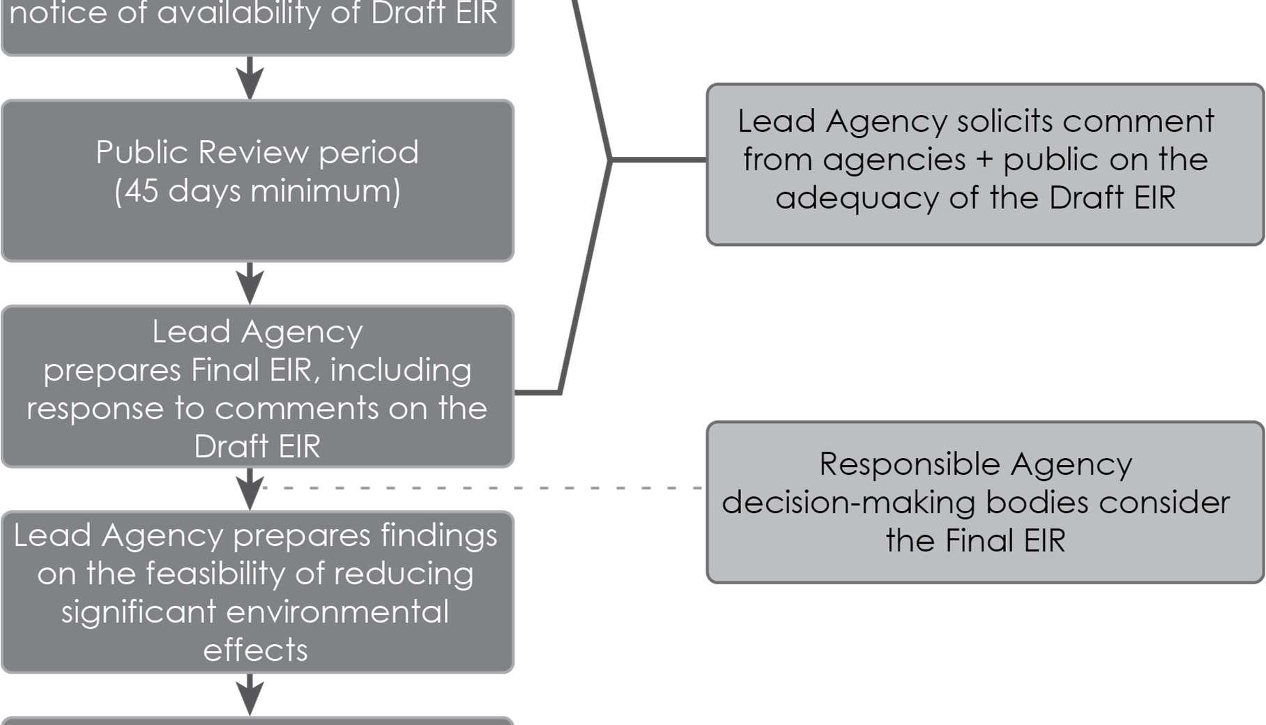

City of Orinda Plan Orinda 1-16
This page intentionally left blank.
2.1
2.2 Lead Agency Name, Address and Contact Person
2 Project Description
The project also includes additional miscellaneous amendments to the General Plan, the Zoning Code, and the Zoning Map to maintain consistency with the Housing Element Update and DPP; and minor updates to the Growth Management Element consistent with Contra Costa Transportation Authority guidance
The project title is “Plan Orinda,” a city wide planning effort that involves three main components:
Project Description Draft Environmental Impact Report 2-1
City of Orinda 22 Orinda Way Orinda, California 94563
The 2023 2031 Housing Element Update, which would amend the City of Orinda General Plan (General Plan) to address the State mandated 8 year planning horizon for housing development and meeting the Regional Housing Needs Assessment (RHNA) allocation in Orinda. Specifically, the Housing Element Update would replace the 5th Cycle Housing Element with the proposed 6th Cycle Housing Element and update the Land Use Element.
Winnie Mui, Associate Planner
Project Title and Brief Description
Revisions to the Environmental Resources Chapter of the General Plan, including updates to the Safety Element portion to reflect the policies and programs proposed in the Housing Element Update and bring it into alignment with the most current legislation designed to reduce potential impacts from natural and human made disasters.
The project as a whole is referred to in this EIR as “Plan Orinda.” When discussing only the DPP, that abbreviation will be used, and when analyzing the sites outside of the DPP that are identified in the Housing Element Update for residential development, the phrase “Housing Element Sites” will be used. The combined residential development potential identified in the DPP and Housing Element Sites would be sufficient to meet the City’s RHNA obligation for the 6th Cycle Housing Element Update. Aspects of the DPP that are beyond the Housing Element Update evaluation are called out separately throughout the analysis.
The Downtown Precise Plan (DPP), a proposed 30-year planning document for the downtown area of Orinda that would involve updating the General Plan and rezoning parcels to allow for mixed residential and commercial or office uses in the City’s high quality transit corridor.
This section describes the proposed project, including the lead agency, project objectives, project characteristics, and discretionary actions needed for approval.
The Plan Orinda study area considered in this EIR includes the entire city, with the DPP Plan Area delineated from, but contained within, the rest of the Housing Element Update Plan Area (Figure 2-2).
The city also features a Bay Area Rapid Transit (BART) station next to State Route (SR) 24, near the downtown area and the Orinda Theatre District. SR 24 is the major east/west highway, which also serves the adjacent city of Moraga. The other major transportation route in the city is Camino Pablo, which runs northwest to southeast and becomes Moraga Way when it crosses SR 24.
2.4 Project Characteristics
2-2 City of Orinda Plan Orinda
2.3 Project Location
Plan Orinda is a long-range planning effort that will shape the future of development and economic growth in Orinda. These efforts include updates to the Housing Element, the Land Use Element, and the Safety Element section of the Environmental Resources Chapter of the General Plan, and minor updates to the Growth Management Element of the Growth Management Chapter. The DPP effort would include new development standards and the adoption of objective design standards for the area. Plan Orinda efforts also include the adoption of the Downtown Streetscape Master Plan (ConnectOrinda) which was adopted separately in November 2019. Plan Orinda would include several General Plan and Zoning Amendments based on the proposed changes to policies,programs, and land use.
The DPP area would encompass the downtown area, which is at the geographic center of the city. It comprises two sections: The Village and the Theatre District. The Village is the northern portion of downtown Orinda and encompasses about 24 acres. The Theatre District is the area immediately south of SR 24 and includes about 13 acres. The entire DPP Plan Area extends from the Orinda Way and El Toyonal intersection in the north to Camino Encinas in the south, outlined in pink in Figure
Vehicular2-2access to the downtown area is available primarily via Camino Pablo and Highway 24. Several streets provide access to the downtown area from residential districts surrounding the area. From the north, Camino Sobrante meets Orinda Way at an intersection. Further south, Altarinda Road provides access to the downtown area at the intersection of Orinda Way. Camino Pablo is the only road that connects the downtown areas and is bisected by the Orinda BART station and Highway 24. Moraga Way, Brookwood Road, and Bates Boulevard provide access to the southernmost downtown area.
Orinda is in western Contra Costa County, in the greater San Francisco Bay Area of California. The regional location is shown in Figure 2-1 Orinda is bifurcated roughly east to west/southwest by State Route (SR) 24, roughly 8 miles west of where it crosses Interstate 680. The city encompasses approximately 13 square miles (City of Orinda 2020). The city is bordered by the City of Lafayette to the east, the Town of Moraga to the southeast, and unincorporated Contra Costa County to the north and west.
Project Description Draft Environmental Impact Report 2-3
Figure 2-1 Regional Location

2-4
City of Orinda Plan Orinda
Figure 2-2 Plan Orinda Project Location

Element Update includes five possible Housing Element Sites outside of the DPP area as depicted in Figure 2-3. These sites are distributed in the southwest portion of the city and would involve rezoning that would allow for 20 to 25 dwelling units per acre (du/ac) on most sites and 20 to 40 du/ac on the Caltrans – Gateway site (HE-5).
The update to the Housing Element would ensure compliance with State legislation passed since adoption of the General Plan and the 2015 2023 Housing Element. The 2023-2031 Housing Element update would reflect current conditions and include the following:
2.4.1 Housing Element Update
Thecapacity.Housing
The Housing Element Update would involve an update for the 2023 2031 planning period to replace the existing Housing Element in the City’s General Plan. The Housing Element Update establishes policies and programs to further the goal of meeting existing and projected housing needs of all household income levels of the community; provides evidence of the City’s ability to accommodate the RHNA allocation through the year 2031, as identified by the Association of Bay Area Governments (ABAG); and puts in place a rezone program needed to identify the required housing
Housing Needs Assessment. A discussion of the city’s demographic and economic characteristics, along with growth projections for the San Francisco Bay Area, housing growth forecasts compared to recent population and housing growth; and current housing stock in the city. This section also includes an assessment of populations with special housing needs and an assessment of fair housing.
Housing Resources. An evaluation of housing resources, available land suitable for residential development, and estimated capacity in identified DPP Sites and Housing Element Sites where the City’s RHNA could be met. This section also discusses financial and administrative resources and opportunities for energy conservation.
Housing Element Update Process. An introduction and overview of the 2023-2031 Housing Element update process and legal requirements, including data sources used to compile the Housing Element and its relationship to other General Plan Elements. This section also details the extent of public participation in the development of the Housing Element.
Housing Constraints. An analysis of market, regulatory, and environmental constraints on housing production, cost, and maintenance.
Housing Plan. This section details the goals and policies of the 2023-2031 Housing Element, a list of the programs that will help achieve these goals and policies, and a summary of objectives with general timeframes in which those objectives might be achieved, along with the agency responsible for implementing the program.
Project Description Draft Environmental Impact Report 2-5
State law requires that housing elements are updated every 8 years (California Government Code Sections 65580 to 65589.8). The proposed update, the 2023-2031 Housing Element, identifies sites adequate to accommodate a variety of housing types for all income levels and needs of special population groups defined under state law (California Government Code Section 65583); analyzes governmental constraints to housing maintenance, improvement, and development; addresses conservation and improvement of the condition of existing affordable housing stock; and outlines policies that promote housing opportunities for all persons.
2-6
Figure 2-3 Proposed Housing Element Sites Outside of the DPP Area
City of Orinda Plan Orinda

Regional Housing Needs Assessment (RHNA) Allocation
Income Level Percent of Area Median Income (AMI) Units Percent
Project Description Draft Environmental Impact Report 2-7
Above Moderate >120% 557 41%
Table 2-2 City of Orinda Regional Housing Needs Allocation Income Category (Percent of Contra Costa County AMI) HousingTotalUnitsVery Low (31-50%) (51Low-80%) (81Moderate-120%) Above Moderate (120% or more) RHNA Housing units 372 215 215 557 1,359 With 25 percent buffer 93 54 N/A N/A 147 Totals 465 269 215 557 1,506 AMI = Area Median Income Source: ABAG 2021
The Housing Element Update must address the City's fair share of the regional housing need and specific state statutory requirements and must reflect the vision and priorities of the local community. HCD requires local jurisdictions to identify enough future housing sites inventory to not only cover the jurisdiction’s 6th Cycle RHNA, but also recommend that the City provide for an additional buffer capacity to ensure compliance with the “No Net Loss Law” (Government Code Section 65863). The “No Net Loss” Law requires the City to maintain sufficient sites to meet the RHNA for all income levels throughout the planning period. Without a buffer, if a jurisdiction rezones a site or if the jurisdiction approves a project at a different income level than shown in the sites inventory, the city may be required to identify additional sites. The recommendation from HCD is to adopt a housing site inventory with a buffer of at least 15 to 30 percent over the allocated RHNA. The City has included a 25 percent buffer of 147 dwelling units in the lower income category, for a total possible 1,506 dwelling units on the combined Housing Element Sites and the DPP. The RHNA allocation and the 25 percent buffer are detailed in Table 2-2.
Low 51-80% 215 16%
The California Department of Housing and Community Development (HCD) allocated 441,176 housing units to the ABAG to distribute among the regionals nine counties (Alameda, Contra Costa, Marin, Napa, San Francisco, San Mateo, Santa Clara, Solano, and Sonoma) and 101 cities and towns. The process by which each city and county in the ABAG region is allocated a required number of housing units for the planning cycle is called the RHNA. As shown in Table 2-1, Orinda’s RHNA allocation for the 2023 2031 planning period is 1,359 units, which is distributed among four income categories (ABAG 2021).
Source: ABAG 2021
Table 2-1 RHNA Allocation and Percentage of Income Distribution for Orinda
Total – 1,359 100%
Very Low 0-50% 372 27%
Moderate 81-120% 215 16%
1. Meet the State required RHNA for 6th Cycle Housing Element planning period of 2023 2031;
Although the City must plan for housing development, it does not directly build housing or require that it be built. Instead, the identification of housing sites is intended to plan for and encourage housing development. Development of the identified sites would be dependent on market forces and, in the case of affordable housing, available subsidies.
3. Identify housing policies and programs that enable the development of additional units and the preservation of existing units, that reduce governmental constraints to building housing, and that affirmatively further fair housing across the board;
Housing Element Update Objectives
Table 2-3 lists the Housing Element Sites outside the DPP area and presents the current allowable densities, land use and zoning changes with associated new allowable densities, the size of the site, and the number of realistic potential units that could be accommodated on each site. The net increase presented in this table is the upper end of the permitted density range as this EIR analyzes maximum build out proposed by the Housing Element Update, assuming that even though they may not all be constructed, it is possible for them to be built within the 8-year planning horizon covered by the 6th cycle.
Housing Element Sites
The Housing Element Update includes the following goals and objectives:
The five Housing Element Sites identified in the Housing Element Update outside of the DPP area are depicted in Figure 2-3 in green and labeled with their corresponding site number. It is important to note that the identification of housing sites in the City’s Housing Element does not necessarily mean that the sites would be developed with housing at the potential unit count proposed.
2. Bring the General Plan into conformance with recently enacted State law;
City of Orinda Plan Orinda 2-8
4. Identify housing sites with a collective capacity to meet the City’s RHNA, with buffer capacity; and
2.4.2 Downtown Precise Plan
5. Locate most housing sites in existing urban areas, near transit and commercial services
Downtown Precise Plan Sites
Within the DPP planning area, 43 parcels are identified as potential sites for residential development, either as vertical mixed use or horizontal mixed use (i.e., allowing either commercial or residential development without a requirement that it be vertically integrated).
The DPP would revise the downtown development standards and update mixed use and residential design standards for the Theatre and Village districts, which would be accomplished through General Plan amendments and zoning code changes. The DPP would also include an evaluation of the impact on utilities and infrastructure in the area; changes to development standards including residential density, building heights, number of building stories, and allowed uses; and parking requirements. The San Pablo Creek Restoration and trail concept are included as part of the DPP. Future creek restoration projects under the San Pablo Creek Restoration and trail project would undergo subsequent environmental review when private property owners develop schematic designs and as such, it is not analyzed in this EIR.
3 Current maximum height is 27 feet and would remain the same
HE-5 Caltrans – Gateway No address, off California Shakespeare Theater Way 10 100% RH-40 SemipublicPublic 0 40 408 1,141 50
# Location Acreage PercentageBuildableofSite1 ProposedZoning CurrentZoning ExistingUnits Proposeddu/ac MaximumAllowableUnits PopulationEstimate2 HeightProposed(ft)
1 In some cases, only a portion of the parcel could be developed with housing. This percentage represents the maximum portion of the site that could provide housing as estimated by the City and housing consultant.
HE-3 St. John Orthodox Church 501 Moraga Way 4.94 33% RH-25 Single Family 0 25 41 114 273
Site
HE-2 St. Mark’s Church 451 Moraga Way 4.48 50% RH-25 Single Family 0 25 56 157 273
HE 1 Holy Shepherd Lutheran Church 433 Moraga Way 3.22 33% RH-25 Single Family 0 25 27 75 273
Total 74.59 7654 2,142 du/ac = dwelling unit per acre ft = feet
Project Description Draft Environmental Impact Report 2-9 Table 2-3 Housing Element Sites: Proposed Zoning Changes and Development Assumptions Outside the DPP Area
HE-4 Portion of Miramonte High School 750 Moraga Way 51.95 18% RH-25 Open Space 0 25 234 655 273
2 Population estimates were calculated using the California Department of Finance persons per household estimate of 2.78, which was rounded up to 2.8 for the purposes of this analysis. Numbers may not add up due to rounding.
4 Numbers may not add up due to rounding
The purpose of the DPP is to revise the City’s downtown development standards and establish mixed use and residential design standards for the Theatre and Village Districts that would revitalize the area and guide the long range social, economic, and physical growth of Orinda’s downtown (City of Orinda 2022).
The DPP includes the following objectives:
3. To maintain the village “small town” character of downtown while encouraging development that is compatible with existing uses, the pedestrian environment, and streetscape
Table 2-4 lists the DPP sites and presents the currently allowable densities, zoning changes with associated new allowable densities, the size of the site, and the number of realistic potential units that could be accommodated on each site. The table also provides estimated commercial and office square footage that could be redeveloped. The net increase presented in this table is the upper end of the permitted density range as this EIR analyzes maximum build out proposed by the Housing Element Update and DPP, assuming that even though they may not all be constructed, it is possible for them to be built within the 8 year planning horizon covered by the 6th cycle. The table also includes an estimate of commercial space that may be developed (the estimate is based on previous development patterns for mixed use sites in Orinda). Each site’s housing units and commercial space is an estimate based on conceptual scenarios.
Within the DPP Plan Area, nine parcels are identified as public and semipublic or residential – multi family sites. These sites would not be rezoned and would not undergo changes to existing uses or development standards.
Downtown Precise Plan Project Objectives
DPP Sites are shown in Figure 2-4 and Figure 2-5. Sites that are identified as public and semipublic or residential multi family sites are depicted in blue.
Within the DPP Plan Area, 33 parcels are identified as commercial or office development sites. These sites would be rezoned to either Downtown Core or Downtown General designations and would allow for the addition of residential development. New development projects would be required to comply with new objective design standards should they undergo redevelopment within the existing building footprint. For the purposes of the environmental analysis, the amount of commercial square footage would not be expected to substantially change, although additional residential square footage is projected.
2. To increase open spaces and community gathering places to foster greater connections with nature
1. To encourage a mix of uses including employment opportunities, housing, recreational and cultural uses
4. To incorporate varying architectural building types with appropriate detailing
5. To develop the area with complimentary uses consistent with the current scale and size of surrounding development
City of Orinda Plan Orinda 2-10
Figure 2-4 DPP Sites West of State Route 24
Project Description Draft Environmental Impact Report 2-11

2-12
City of Orinda Plan Orinda
Figure 2-5 DPP Sites East of State Route 24

Project Description Draft Environmental Impact Report 2-13 Table 2-4 DPP Housing Element Sites: Proposed Zoning Changes and Development Assumptions
DPP-19 Altarinda Road 0.97 100 DG Downtown Office 0 25 24 68 35 7,841
DPP-23 23 Altarinda Road 0.60 100 DG Downtown Office 0 25 15 42 35 4,591
DPP-26 99 Brookwood Road 0.26 100 DC-L Downtown Office 0 25 7 18 45 4,752
DPP-31 89 Moraga Way 0.23 100 DG Downtown Office 0 25 6 16 35 2,159
DPP-22 19 Altarinda Road 0.92 100 DG Downtown Office 0 25 23 64 35 8,214
DPP 6 Avenida de Orinda 0.34 100 DC Downton Commercial 10 85 29 81 55 N/A
DPP-9 23 Avenida de Orinda 0.35 100 DC-L Downtown Commercial 10 85 30 83 55 13,296
DPP-18 9 Altarinda Road 1.04 100 DG Downtown Office 0 25 26 73 35 6,930
DPP-38 81 Moraga Way 0.50 100 DC Downtown Commercial 10 30 15 42 45 9,269
DPP-13 Brookwood Road 0.15 100 DC Downtown Commercial 10 65 10 27 55 N/A
DPP-8 20 Avenida de Orinda 0.33 100 DC-L Downtown Commercial 10 85 28 79 55 N/A
DPP-11 79 Orinda Way 1.05 100 DC Downtown Commercial 10 85 89 250 55 18,890
DPP-16 64 Moraga Way 0.57 100 DC Downtown Commercial 10 65 37 104 55 14,720
DPP-30 96 Davis Road 0.57 100 DG Downtown Office 0 25 14 40 35 7,820
DPP-33 5 Santa Maria Way 0.36 100 DG Downtown Office 0 25 9 25 35 4,217
DPP-39 1 Orinda Way 0.39 100 DC-L Downtown Commercial 10 30 12 33 55 7,862
DPP-35 22 Bryant Way 0.33 100 DC-L Downtown Commercial 10 30 10 28 45 1,548
# Location Acreage PercentageBuildableof Sites Proposed Zoning Current Zoning
DPP-37 67 Moraga Way 0.33 100 DC Downtown Commercial 10 30 10 28 45 1,680
DPP-7 10 Avenida de Orinda 0.32 100 DC Downtown Commercial 10 85 27 76 55 14,854
DPP-28 112 Camino Pablo 0.41 100 DG Downtown Office 0 25 10 29 35 5,053
DPP-25 2 Bates Boulevard 0.89 100 DG Downtown Office 0 25 22 62 35 3,482
Proposeddu/acre AllowableMaximumUnits PopulationEstimate1 Proposed Height (ft) Estimated New or Redeveloped Commercial (sf)
DPP-42 19 Orinda Way 0.57 50 DC-L Downtown Commercial 10 30 17 48 45 10,033
du/acreCurrent
Site
DPP-24 1 Bates Boulevard 0.99 100 DG Downtown Office 0 25 25 69 35 11,212
DPP-29 89 Davis Road 0.97 100 DG Downtown Office 0 25 24 68 35 15,786
DPP-10 63 Orinda Way 0.11 100 DC Downtown Commercial 10 85 9 26 55 5,837
DPP-40 9 Orinda Way 0.66 100 DC Downtown Commercial 10 30 20 55 55 2,820
DPP-15 50 Moraga Way 0.24 100 DC Downtown Commercial 10 65 16 44 55 11,396
DPP-27 8 Camino Encinas 0.91 100 DC-L Downtown Office 0 25 23 64 45 8,672
DPP-36 21 Moraga Way 0.22 100 DC Downtown Commercial 10 30 7 18 45 8,160
DPP-17 80 Moraga Way 0.34 100 DC Downtown Commercial 10 65 22 62 55 7,023
DPP-14 6 Camino Pablo 0.70 100 DC Downtown Commercial 10 65 46 127 55 15,349
DPP-41 17 Orinda Way 0.35 50 DC-L Downtown Commercial 10 30 11 29 45 2,744
DPP-20 11 Altarinda Road 1.00 100 DG Downtown Office 0 25 25 70 35 15,824
DPP-34 140 Brookwood Road 1.09 100 DC-L Downtown Commercial 10 30 33 92 45 15,260
DPP-32 93 Moraga Way 0.55 100 DG Downtown Office 0 25 14 39 35 9,102
DPP-21 15 Altarinda Road 1.00 100 DG Downtown Office 0 25 25 70 35 13,848
DPP-12 115 Orinda Way 0.10 100 DC Downtown Commercial 10 85 9 24 55 1,691
ProposedZoning CurrentZoning
DPP-4661OrindaWay 0.28 100 DC DowntownCommercial 10 85 24 67 55 1,233 DPP-47200OrindaWay 2.16 50 DG DowntownCommercial 10 30 65 181 55 42,049 DPP-48VashellWay 0.15 100 DC-L DowntownCommercial 10 30 5 13 45 N/A
Site# Location Acreage PercentageBuildableofSites
City of Orinda Plan Orinda 2-14
du/acreCurrent Proposeddu/acre AllowableMaximumUnits PopulationEstimate 1 ProposedHeight(ft)
EstimatedNew orRedevelopedCommercial(sf)
DPP-4321OrindaWay 0.68 50 DC-L DowntownCommercial 10 30 20 57 45 6,730
0 30 62 174 55 n/a DPP-591CaminoSobrante 0.62 100 DC DowntownCommercial
0 30 7 20 55 11,776 DPP-6211MoragaWay 0.19 100 DC DowntownCommercial 0 30 6 16 45 n/a DPP-6337MoragaWay 0.1 100 DC DowntownCommercial 0 30 3 8 45 6,344 DPP-6451MoragaWay 0.18 100 DC DowntownCommercial 0 30 5 15 45 9,308 DPP-6551MoragaWay 0.21 100 DC DowntownCommercial 0 30 6 18 45 n/a DPP-6661MoragaWay 0.25 100 DC DowntownCommercial 0 30 8 21 45 10,400 DPP-6785MoragaWay 0.32 100 DG DowntownOffice 0 25 8 22 45 4,921 DPP-681NorthwoodDrive 0.18 100 DC-L DowntownOffice 0 25 5 13 35 2,961 DPP-69OrindaWay 0.33 100 DC-L DowntownCommercial 0 30 10 28 45 n/a DPP-704OrindaWay 5.71 100 DG DowntownOffice 0 30 143 400 55 92,046 DPP-7111OrindaWay 0.79 100 DC DowntownCommercial 0 30 24 66 35 2,280 DPP-7214OrindaWay 0.43 100 DC DowntownCommercial 0 30 13 36 45 9,400 DPP-7323OrindaWay 1.62 100 DC-L DowntownCommercial 0 30 49 136 45 24,400 DPP-7425OrindaWay 1.1 100 DG DowntownCommercial 0 30 33 92 45 24,336 DPP-7525AOrindaWay 0.47 100 DG DowntownCommercial 0 30 14 39 35 n/a DPP-7629OrindaWay 0.82 100 DG DowntownCommercial 0 30 25 69 35 9,216 DPP-7733OrindaWay 0.4 100 DG DowntownCommercial 0 30 12 34 35 5,016 DPP-7837OrindaWay 0.09 100 DC DowntownCommercial 0 30 3 8 35 12,480 DPP-792TheatreSquare 1.92 100 DC DowntownCommercial 0 30 58 161 55 81,546
Total 26.20 974 2,727 509,260 DPP-493AltarindaRoad 1.21 100 DG DowntownOffice 0 25 30 85 35 15,468 DPP-50BrookwoodRoad 0.15 100 DC-L DowntownCommercial 0 30 5 13 45 n/a DPP-51CaminoEncinas 0.03 100 DC-L DowntownCommercial 0 30 1 3 45 n/a DPP-52CaminoEncinas 0.01 100 DC-L DowntownCommercial 0 30 0 1 45 n/a DPP-5312CaminoEncinas 0.99 100 DC-L DowntownOffice 0 25 25 69 45 14,344 DPP-54CaminoPablo 0.21 100 DC-L DowntownCommercial 0 30 6 18 45 n/a DPP-55CaminoPablo 0.35 100 DG DowntownCommercial 0 30 11 29 35 n/a DPP-56CaminoPablo 0.57 100 DG DowntownCommercial 0 30 17 48 35 n/a DPP-57CaminoPablo 0.42 100 DG DowntownCommercial 0 30 13 35 35 n/a DPP-58CaminoSobrante 2.07 100 DC DowntownCommercial
0 30 19 52 55 16,912 DPP-602CaminoSobrante 0.71 100 DC DowntownCommercial 0 30 21 60 55 50,392 DPP-615MoragaWay 0.24 100 DC DowntownCommercial
DPP-4427OrindaWay 1.85 50 DG DowntownCommercial 10 30 56 155 55 14,904 DPP-4531OrindaWay 0.97 50 DG DowntownCommercial 10 30 29 81 55 4,700
Proposeddu/acre AllowableMaximumUnits PopulationEstimate 1 Proposed(ft)Height
Public, Semi-public and Utility Districtn/an/a6.6826 Orinda WayDPP-87 3,81535n/an/an/a0
du/acreCurrent
Estimated
Public, Semi-public and Utility Districtn/an/a4.5530 Santa Maria WayDPP-89 40 Santa Maria WayDPP-90 40 Santa Maria Way 40 Santa Maria Way 2.322.224.47 n/an/a 46.422.20 20,00035n/an/an/a 4,000
New or Redeveloped Commercial (sf)
Downtown CommercialDC1000.04Vashell WayDPP-80 12,40045114300Downtown CommercialDG1000.1350 Vashell WayDPP-81 1,80364422.86Total 73,60035n/an/an/a55.1Residential Medium-Density Districtn/an/a1.452 Irwin WayDPP-82 32,00035n/an/an/a0
# Location Acreage PercentageBuildableofSites Proposed Zoning Current Zoning
Public, Semi-public and Utility Districtn/an/a1.122 Orinda WayDPP-85 4,66235n/an/an/a0
Public, Semi-public and Utility Districtn/an/a0.7424 Orinda WayDPP-86 20,60035n/an/an/a0
Site
Project Description2-15Draft Environmental Impact Report
Public, Semi-public and Utility Districtn/an/a4.8910 Irwin WayDPP-83 82,50035n/an/an/a35.6Residential Medium-Density Districtn/an/a3.5620 Irwin WayDPP-84 13,90735n/an/an/a0
Public, Semi-public and Utility Districtn/an/a0.8720 Santa Maria WayDPP-88 11,93235n/an/an/a0
1 Population estimates were calculated using the California Department of Finance persons per household estimate of 2.78, which was rounded up to 2.8 for the purposes of this analysis. Numbers may not add up due to rounding. ft = feet sf = square feet n/a = not applicable
Public, Semi-public and Utility District Residential DistrictResidentialMedium-DensityMedium-Density District, High Density Overlay
n/a5531300
This page intentionally left blank.
City of Orinda Plan Orinda 2-16
2.4.3 Population Projections
2.4.5
Proposed Zoning Changes
Proposed Height Changes
Objective Design Standards
Plan Orinda envisions the development of additional housing that, if built, would result in an increase in population within the City of Orinda. As shown in Table 2-3, a maximum of 765 dwelling units would be developed on the five Housing Element Sites outside of the DPP As shown in Table 2-4 and Figure 2-5, within the DPP area, a maximum of 1,618 dwelling units 1 would be developed, for a total of 2,383 new dwelling units under Plan Orinda buildout The total estimated additional population within the City would be 6,672 2 This analysis assumes that the identified sites are developed to the maximum extent feasible.
2.4.4
Under the DPP, the existing Downtown Commercial (DC) and Downtown Office (DO) zones would allow a mix of uses, including residential, commercial, and office. Zoning standards would be revised to allow development up to 85 dwelling units per acre (du/acre) that could be up to 55 feet in height. The current permitted density in the Downtown Commercial (DC) district is a maximum of 10 du/acre, whereas Downtown Office (DO) prohibits residential uses. The General Plan Update would adjust the permitted density for the Downtown Commercial and Downtown Office districts to a range of 25 to 85 du/acre. This adjustment would comply with HCD’s requirement of identifying housing inventory sites that allow for at least 20 du/acre to accommodate very low and low income units.
As a part of the proposed zoning changes, objective design standards regulating aesthetics (architectural style, building proportions, building types, civic spaces, etc.) would be adopted for the DPP area. The DPP objective design standards would apply to all existing DC and DO designated parcels should they undergo redevelopment. For the Housing Element sites outside of the DPP area, new residential objective design standards will also be developed.
Housing Element Sites outside of the DPP area would be subject to the existing maximum height of 27 feet, with the exception of Housing Element Site HE-5, located off California Shakespeare Theater Way, which would have a maximum height of 50 feet. The DPP would allow for an increase in heights for sites that would include residences. DPP sites that would maintain the existing 35 foot height limit would include DPP-18 through DPP-25 and DPP-28 through DPP 33. DPP sites that would have an increase in height from 35 to 45 feet would include DPP 26, DPP 27, DPP 34 through DPP 38 and DPP 41 through DPP 43, and DPP 48. Sites that would have increased heights from 35 to 55 feet would include DPP 6 through DPP 17, DPP 39, DPP 40, and DPP 44 through DPP 47. A complete list of the DPP residential sites and their proposed allowed heights is shown in Table 2-4.
Project Description Draft Environmental Impact Report 2-17
1 Calculation: DPP Sites total up to 1,618 dwelling units.
When a local jurisdiction cannot demonstrate that there are sufficient vacant or underutilized sites to adequately meet their RHNA allocation, a “rezoning program” must be adopted. A rezoning program ensures that there are enough sites with sufficient densities to address the housing need identified through the RHNA.
2 Calculation: 2,383 dwelling units times 2.8 persons per household = 6,672 new residents, using California Department of Finance estimates of 2.8 residents per household in Orinda (rounded).
Commercial and office uses in the DPP area would be allowed to have a maximum height of 45 feet. Public/Semi public uses would continue to have a maximum height of 35 feet. A complete list of the DPP commercial and office sites and their associated maximum heights are shown in Table 2-4. There would be no other proposed height changes to development outside of the DPP area and the Housing Element Sites.
Proposed height changes for Housing Element Sites are shown in Figure 2-6. Heights of 27 feet are shown in blue and height changes to 50 feet are shown in purple.
2-18
The City’s Safety Element is intended to include safety considerations in the planning and decision making process by establishing policies related to future development. The Safety Element was last amended in 2011 to incorporate policies of the Local Hazard Mitigation Plan. Areas of the Safety Element that would be updated include geology and seismicity, stormwater management and flooding, fire hazards, disaster response, and a climate change section, including a vulnerability assessment. Other considerations of the Safety Element would include discussions of peak demand water supply requirements, and minimum road widths and clearances around structures.
2.4.6 Safety Element Update
Proposed height changes for DPP sites are shown in Figure 2-7 Height changes to 45 feet are shown in orange, and changes to 55 feet are shown in purple. Heights remaining at 35 feet are shown in blue.
City of Orinda Plan Orinda
The Safety Element is a state mandated General Plan element that must identify potential natural and human created hazards that could affect the City of Orinda’s residents, businesses, and services. The purpose of the Safety Element is to establish a framework that anticipates these hazards and prepares the community to minimize exposure to these risks. The Safety Element update would include goals, policies, and actions to minimize the hazards to safety in and around Orinda. It would identify the natural and human caused hazards that would affect existing and future development, describe present and expected future conditions, and set policies and standards for improved public safety. This would include efforts to minimize physical harm to the buildings and infrastructure in and around Orinda to reduce damage to local economic systems, community services, and ecosystems.
Approved in 2019, Assembly Bill (AB) 747 requires each jurisdiction to review and update as necessary the Safety Element of its General Plan to identify evacuation routes and capacity, safety, and viability under a range of emergency scenarios. This information must be included by January 1, 2022, or upon approval of the next update to the Local Hazard Mitigation Plan. The Safety Element would be revised to include the AB 747 evacuation analysis that typically would be done with the next update of the Local Hazard Mitigation Plan. Also approved in 2019, Senate Bill (SB) 99 requires jurisdictions, upon the next revision of the Housing Element on or after January 1, 2020, to review and update the safety element to include information identifying residential developments in hazard areas that do not have at least two emergency evacuation routes. In accordance with Senate Bill 379, safety elements must also include a climate change vulnerability assessment, measures to address vulnerabilities, and comprehensive hazard mitigation and emergency response strategy. The proposed Safety Element Update also addresses the requirements of these bills.
Figure 2-6 Housing Element Sites Height Limits
Project Description Draft Environmental Impact Report 2-19

Figure 2-7 DPP Proposed Height Limits
City of Orinda Plan Orinda
2-20

Adoption of the Safety Element
Once City Council adopts the 2023 2031 Housing Element, it will be submitted to the HCD for final Incertification.addition,the
Amendments to Growth Management Element
Certification of the EIR prepared for Plan Orinda
Project Description Draft Environmental Impact Report 2-21
Adoption of the 2023 2031 Housing Element into the General Plan
Adoption of updates to the Land Use Map and associated text changes to affected Elements of the General Plan (including Land Use) to re designate land uses for certain selected housing sites
The City of Orinda City Council would need to take the following discretionary actions in conjunction with the Housing Element Update, the DPP, and changes to the other General Plan Elements:
Adoption of the Downtown Precise Plan
Adoption of Objective Design Standards
2.5 Required Discretionary Actions
Board of Forestry and Fire Protection (Board), which is a government appointed body within the California Department of Forestry and Fire Protection (CalFire), is responsible for reviewing the Safety Element under Government Code Section 65302.5. The Board would review the Safety Element and respond to the City with its findings regarding the uses of land and policies in State Responsibility Areas (SRAs) or Very High Fire Hazard Severity Zones (VHFHSZs) that would protect life, property, and natural resources from unreasonable risks associated with wildfires, and the methods and strategies for wildfire risk reduction and prevention within SRAs or VHFHSZs (California Board of Forestry and Fire Protection 2022).
Text Amendments to the City of Orinda Zoning Ordinance (Title 17 of the Orinda Municipal Code) to reflect the DPP and Housing Element changes
Amendments to the City of Orinda Zoning Map to reflect the DPP and Housing Element changes
This page intentionally left blank.
City of Orinda Plan Orinda 2-22
The Mediterranean climate of the region and coastal influence produce moderate temperatures year round, with rainfall concentrated in the winter months. Air quality in the Bay Area Air Quality Management District is in nonattainment for ozone, particulate matter equal to or less than 10 micrometers in diameter or less (PM10), and particulate matter equal to or less than 2.5 micrometers in diameter or less (PM2.5) (BAAQMD 2017).
3.2.1
The City of Orinda is located in southwest Contra Costa County, in the eastern part of the San Francisco Bay Area (East Bay). It is bordered by the City of Lafayette to the northeast and Town of Moraga to the south. Both cities have similar land use patterns to Orinda, with largely single family residences, some multi family buildings, and businesses that serve the residential, suburban nature of the city. The city is in a valley surrounded by rolling hills with mature trees. Surrounding open space areas contribute to this semi rural character including: Briones Regional Park is situated northeast and Tilden Regional Park, the Siesta Valley Recreation Area, and Sibley Volcanic Regional Preserve are northwest, west, and southwest of the city, respectively.
The Plan Orinda plan area consists of the entire City of Orinda. The Housing Element Sites are located throughout the City and within the Downtown Precise Plan (DPP) area along Camino Pablo and Moraga Way in downtown Orinda as shown in Section 2, Project Description, Figures 2 4 and Existing2-5.
Housing Element Update
This section provides a general overview of the environmental setting for the proposed project. More detailed descriptions of the environmental setting for each environmental issue area can be found in Section 4 Environmental Impact Analysis.
3.1 Regional Setting and Surrounding Land Uses
The Housing Element Sites outside the DPP area are situated throughout the city and surrounded by a range of uses including transportation facilities, parking lots, residential and commercial uses, and office, government, and institutional (school) uses. Adjacent land uses include recreation areas, single family residences, an apartment complex, and churches. The area slated for development of
land uses in the city include single family residences, multi family residences, commercial, government, church (institutional), educational uses, and BART uses The range of housing types reflects the city’s largely hilly topography and suburban development patterns. Over 92 percent of the city’s housing stock is made up of single family units, either attached or detached; apartments and condominiums account for 7 percent of the housing stock. As of 2021, Orinda has 7,194 total dwelling units (California Department of Finance [DOF] 2021).
3.2 Existing Land Uses and Zoning
The city is regionally accessible via State Route 24 and Camino Pablo/San Pablo Dam Road, and from US Interstate 680 (I 680) to the east of the city. The Orinda Bay Area Rapid Transit (BART) station, which bisects the Downtown Orinda area, provides regional public transportation access to the area. The city itself is approximately 12.8 square miles of hilly terrain.
3 Environmental Setting
Environmental Setting Draft Environmental Impact Report 3-1
within the site
the Holy Shepherd Lutheran Church site (HE 1) is partially developed with a parking lot and the remainder of the site areas slated for development are undeveloped and dominated by grasses. The remaining four sites are and covered with low vegetation and trees.
HE 1 Holy 433LutheranShepherdChurchMoragaWay 3.22 33% Residential: Single Family Low Density RL-20
HE-2 St. Mark’s Church 451 Moraga Way 4.48 50% Residential: Single Family Low Density RL-20
NumberSite
Table 3-1 Housing Element Sites Current Land Use and Zoning Outside of the DPP Area
HE-4 Undeveloped Portion of Miramonte High School Site 750 Moraga Way 51.95 18% Open PreservationSpace: of Natural Resources, Managed Production of Resources, Public Health and Safety PS
Percent
The City of Orinda General Plan land use designations for the Housing Element Sites outside of the DPP area include residential low density and public and semipublic land use classifications. The sites include both undeveloped and underdeveloped parcels. A list of the Housing Element Sites, outside of the DPP area, with current General Plan land use designations and zoning is provided in Table 3-1 and the sites current zoning designations are shown in Figure 3-1
Location AcreageTotal1
HE-5 Caltrans – Gateway No address, off California Shakespeare Theater Way 10.19 100% Public and Semipublic No zoning designation (part of Caltrans ROW)
ROW = right of way site area
and does not reflect the total buildable
City of Orinda Plan Orinda 3-2
of Site Assumed DevelopmentResidentialfor Current Land Use Designation Current Zoning
1 The total acreage presented is the total area of the
The Housing Element sites (HE 1, HE 2, and HE 3) outside the DPP area are primarily designated as Residential Single Family: Low Density and are zoned as Residential Low Density – Twenty Thousand Square Feet (RL 20), which encompasses parcels with a minimum net lot size of 20,000 square feet. Housing Element Site HE 4 is designated as Open Space, which allows for the preservation of natural resources, managed production of resources, public health and safety, and is zones as Public Semipublic. Housing Element Site HE 5 is designated as Public and Semipublic and does not have a zoning designation as it is part of the Caltrans right of way.
HE-3 St. John Orthodox 501ChurchMoraga Way 4.94 33% Residential: Single Family Low Density RL-20
Environmental Setting Draft Environmental Impact Report 3-3
Figure 3-1 Housing Element Sites Existing Zoning Designations

Business, Professional Office and Public and Semipublic General Plan designations are largely concentrated along Orinda Way and Moraga Way, in the downtown area. Existing zoning of the DPP area is shown in Figure 3-2
A list of the DPP sites that would be rezoned to allow for mixed use residential development that currently consist of commercial or office sites and their current land use and current zoning is provided in Table 3-3. While these sites would allow mixed use residential development, they are not identified as Housing Element sites.
City of Orinda Plan Orinda 3.2.23-4
Most of the area surrounding the downtown is low and very low density single family residential development and open space. Land uses surrounding the downtown area consist of utility, open space, and low density single family residential to the west; low density single family residential and park and recreation to the north and east; and very low density, single family residential to the south. There are BART station parking lots within the DPP planning area, as is the BART rail alignment and SR 24; however, these sites are not part of the DPP Plan Area. The DPP development sites are completely developed with uses such as parking lots, businesses, offices, gas stations, and shopping centers. Of the DPP development sites, there is one site with a vacant building: 10 Avenida de CommunityOrinda.
The current General Plan land use designations for the DPP area are Residential – Multifamily, Public and Semi Public, Community Business, and Business and Professional Offices (City of Orinda 2020). In the Village District, parcels directly abutting Camino Pablo west of Orinda Way are zoned Downtown Commercial District (DC) and parcels to the east of Orinda Way are zoned Public and Semipublic District (PS), Residential Medium Density District (RM), and Downtown Office District (DO). Parcels in the Theatre District are zoned DC, with parcels zoned DO in the southernmost tip of the Plan Area.
As of January 2020, approximately 26 percent of the parcels in downtown Orinda were developed with general retail uses, 29 percent with food and grocery uses, 19 percent with financial and other service uses, 6 percent with office uses, 11 percent with other uses, and 11 percent of the developable area was vacant (City of Orinda 2020).
DPP Residential Sites (Housing Element sites)
A list of the DPP sites that would be rezoned to include residential development and their current land use and current zoning is provided in Table 3-2 These sites are considered DPP Housing Element sites and are specifically identified in the Housing Element.
DPP Non-Housing Element Sites
Downtown Precise Plan Area
Note: The Vista Verde site is in the process of being rezoned to Residential: Medium Density as of the date of this document.
Environmental Setting Draft Environmental Impact Report 3-5
Figure 3-2 Existing Zoning of the Downtown Precise Plan Area

DPP 34 140 Brookwood Road Community Business DC 1.09
DPP 40 9 Orinda Way Community Business DC 0.66
DPP 36 21 Moraga Way Community Business DC 0.22
DPP 33 5 Santa Maria Way Business and Professional Office DO 0.36
DPP 11 79 Orinda Way Community Business DC 1.05
ZoningCurrent AcreageTotal
DPP 17 80 Moraga Way Community Business DC 0.34
DPP 32 93 Moraga Way Business and Professional Office DO 0.55
DPP 42 19 Orinda Way Community Business DC 0.57
DPP 38 81 Moraga Way Business and Professional Office DC 0.5
DPP 12 115 Orinda Way Community Business DC 0.1
Current Land Use Designation
DPP 19 Altarinda Road Business Professional Office DO 0.97
DPP 27 8 Camino Encinas Business and Professional Office DO 0.91
Table 3-2 DPP Residential Sites Current Land Use and Zoning
DPP 6 Avenida de Orinda Community Business DC 0.34
DPP 20 11 Altarinda Road Business Professional Office DO 1.0
DPP 37 67 Moraga Way Community Business DC 0.33
DPP 48 Vashell Way Community Business DC 0.15
DPP 28 112 Camino Pablo Public and Semipublic DO 0.41
DPP 13 Brookwood Road Residential Multifamily DC 0.15
DPP 15 50 Moraga Way Community Business DC 0.24
DPP 22 19 Altarinda Road Business Professional Office DO 0.92
DPP 43 21 Orinda Way Community Business DC 0.68
DPP 8 20 Avenida de Orinda Community Business DC 0.33
DPP 29 89 Davis Road Business and Professional Office DO 0.97
DPP 31 89 Moraga Way Business and Professional Office DO 0.23
DPP 25 2 Bates Boulevard Business Professional Office DO 0.89
DPP 9 23 Avenida de Orinda Community Business DC 0.35
DPP 39 1 Orinda Way Community Business DC 0.39
DPP 21 15 Altarinda Road Business Professional Office DO 1.0
DPP 41 17 Orinda Way Community Business DC 0.35
DPP 30 96 Davis Road Business and Professional Office DO 0.57
DPP 24 1 Bates Boulevard Business Professional Office DO 0.99
DPP 46 61 Orinda Way Community Business DC 0.28
Site Number Location
DPP 45 31 Orinda Way Community Business DC 0.97
DPP 16 64 Moraga Way Community Business DC 0.57
DPP 18 9 Altarinda Road Business Professional Office DO 1.04
City of Orinda Plan Orinda 3-6
DPP 26 99 Brookwood Road Business and Professional Office DO 0.26
DPP 10 63 Orinda Way Community Business DC 0.11
DPP 14 6 Camino Pablo Community Business DC 0.7
DPP 23 23 Altarinda Road Business Professional Office DO 0.6
DPP 35 22 Bryant Way Community Business DC 0.33
DPP 47 200 Orinda Way Community Business DC 2.16
DPP 7 10 Avenida de Orinda Community Business DC 0.32
DC = Downtown Commercial DO = Downtown Office
DPP 44 27 Orinda Way Community Business DC 1.85
DPP-55 Camino Pablo Community Business DC 0.35
Table 3-3 DPP Downtown Commercial and Downtown Office Sites Current Land Use and Zoning
DPP-57 Camino Pablo Community Business DC 0.42
ZoningCurrent AcreageTotal
DPP-62 11 Moraga Way Community Business DC 0.19
DPP-67 85 Moraga Way Business and Professional Office DO 0.32 DPP-68 1 Northwood Drive Community Business DO 0.18
DPP-77 33 Orinda Way Community Business DC 0.4
DPP-64 51 Moraga Way Community Business DC 0.18
DPP-70 4 Orinda Way Business and Professional Office DO 5.71
DPP-60 2 Camino Sobrante Community Business DC 0.71 DPP-61 5 Moraga Way Community Business DC 0.24
DPP-54 Camino Pablo Community Business DC 0.21
DPP-69 Orinda Way Community Business DC 0.33
Current Land Use Designation
DPP-72 14 Orinda Way Community Business DC 0.43
Site Number Location
DPP-81 50 Vashell Way Community Business DC 0.13 DC = Downtown Commercial DO = Downtown Office
DPP-80 Vashell Way Community Business DC 0.04
Environmental Setting Draft Environmental Impact Report 3-7
DPP-66 61 Moraga Way Community Business DC 0.25
DPP-73 23 Orinda Way Community Business DC 1.62
DPP 49 3 Altarinda Road Business and Professional Office DO 1.21
DPP-51 Camino Encinas Community Business DC 0.03
DPP-53 12 Camino Encinas Community Business DO 0.99
DPP-76 29 Orinda Way Community Business DC 0.82
DPP-65 51 Moraga Way Community Business DC 0.21
DPP-59 1 Camino Sobrante Community Business DC 0.62
DPP-50 Brookwood Road Community Business DC 0.15
DPP-56 Camino Pablo Community Business DC 0.57
DPP-79 2 Theatre Square Community Business DC 1.92
DPP-71 11 Orinda Way Community Business DC 0.79
DPP-58 Camino Sobrante Community Business DC 2.07
DPP-75 25A Orinda Way Community Business DC 0.47
DPP-63 37 Moraga Way Community Business DC 0.1
DPP-78 37 Orinda Way Community Business DC 0.09
DPP-52 Camino Encinas Community Business DC 0.01
DPP-74 25 Orinda Way Community Business DC 1.1
City of Orinda Plan Orinda 3.33-8
In addition to the specific impacts of individual projects, CEQA requires EIRs to consider potential cumulative impacts of the proposed project. CEQA defines “cumulative impacts” as two or more individual impacts that, when considered together, are substantial or will compound other environmental impacts. Cumulative impacts are the combined changes in the environment that result from the incremental impact of development of the proposed project and other nearby projects. For example, traffic impacts of two nearby projects may be less than significant when analyzed separately but could have a significant impact when analyzed together. Cumulative impact analysis allows the EIR to provide a reasonable forecast of future environmental conditions and can more accurately gauge the effects of a series of projects.
1 EBMUD Sobrante Water Treatment Plan Reliability Improvements project
Cumulative Development
Project No. Project Name
2 Vista Verde Community Housing project
Senior Residential (38 units) City of Orinda, 2022
Land Use / Size
5500 Amend Road, El Sobrante, Contra Costa County Infrastructure
4 Countryhouse Memory Care 1 Wilder Road
10 Irwin Way
3 25A Orinda Way
Project Location
CEQA requires cumulative impact analysis in EIRs to consider either a list of planned and pending projects that may contribute to cumulative effects or a forecast of future development potential.
Currently planned and pending major projects in Orinda and surrounding areas, including the EBMUD Sobrante Water Treatment Plan Reliability Improvements project, are listed in Table 3-4 These projects are considered in the cumulative analyses in Section 4, Environmental Impact Analysis
25A Orinda Way Retail (18,600 square feet)
Table 3-4 Cumulative Projects List
Senior Residential (52 units)
No Impact. The proposed project would have no effect on environmental conditions or would reduce existing environmental problems or hazards.
4 Environmental Impact Analysis
Significant and Unavoidable An impact that cannot be reduced to below the threshold level given reasonably available and feasible mitigation measures. Such an impact requires a Statement of Overriding Considerations to be issued if the project is approved pursuant to CEQA Guidelines Section 15093
Less than Significant An impact that may be adverse but does not exceed the threshold levels and does not require mitigation measures. However, mitigation measures that could further lessen the environmental effect may be suggested if readily available and easily achievable.
Less than Significant with Mitigation Incorporated. An impact that can be reduced to below the threshold level given reasonably available and feasible mitigation measures. Such an impact requires findings pursuant to CEQA Guidelines Section 15091.
The Executive Summary of this EIR summarizes all impacts and mitigation measures that apply to the proposed project.
The assessment of each issue area begins with a discussion of the environmental setting related to the issue, which is followed by the impact analysis. In the impact analysis, the first subsection identifies the methodologies used and the “significance thresholds,” which are those criteria adopted by the City and other agencies, universally recognized, or developed specifically for this analysis to determine whether potential effects are significant. The next subsection describes each impact of the proposed project, mitigation measures for significant impacts, and the level of significance after mitigation. Each effect under consideration for an issue area is separately listed in bold text with the discussion of the effect and its significance. Each bolded impact statement also contains a statement of the significance determination for the environmental impact as follows:
This section discusses the possible environmental effects of Plan Orinda for the specific issue areas that were identified through the scoping process as having the potential to experience significant effects. A “significant effect” as defined by the CEQA Guidelines Section 15382: means a substantial, or potentially substantial, adverse change in any of the physical conditions within the area affected by the project including land, air, water, minerals, flora, fauna, ambient noise, and objects of historic or aesthetic significance. An economic or social change by itself shall not be considered a significant effect on the environment. A social or economic change related to a physical change may be considered in determining whether the physical change is significant.
.
Environmental Impact Analysis Draft Environmental Impact Report 4-i
Following each environmental impact discussion is a list of mitigation measures (if required) and the residual effects or level of significance remaining after implementation of the measure(s). In cases where the mitigation measure for an impact could have a significant environmental impact in another issue area, this impact is discussed and evaluated as a secondary impact. The impact analysis concludes with a discussion of cumulative effects, which evaluates the impacts associated with the proposed project in conjunction with other planned and pending developments in the area listed in Section 3, Environmental Setting
This page intentionally left blank
City of Orinda Plan Orinda 4-2
Diversity of house placement;
The visual character surrounding the Housing Element Sites outside of the Downtown Precise Plan (DPP) Plan Area consists of low density, low rise residential uses amidst wooded foothills. These include Housing Element Sites HE 1 through HE-4. The surrounding buildings have varied architecture but are primarily large lot single family one to two story residences with long driveways and surrounded by mature trees and vegetation. Housing Element Site HE 5 is surrounded by wooded foothills, mature trees and vegetation. Housing Element Site HE 5 is also adjacent to SR 24 and commuter parking lots, with open wooded hills beyond Due to the mature vegetation surrounding the Housing Element Sites, views through these sites are largely limited to vegetation and distant views of hillsides, as shown in Figure 4.1-1 through Figure 4.1-5.
Heavy tree cover and other vegetation dominating most lots;
This section evaluates the potential impacts on aesthetics, including scenic vistas, scenic resources, visual character and quality, and light and glare, associated with the implementation of the proposed project.
Major visible undeveloped ridgelines and hillsides;
Limited grading and disturbance of existing land contours;
Undisturbed creeks and creek beds;
Orinda’s topographic landscape can be characterized by low lying valleys and rolling hills ranging from 1,000 to 1,700 feet in height. Its natural features consist of mature oak woodlands, waterways such as San Pablo Creek, and grassland. Large undeveloped watershed lands are located to the north and west of the city. Orinda’s built environment can be characterized by low density, low rise single family residences within the hillsides and compact low rise development within its downtown area. Orinda is a nearly built out residential community. Most development occurred between 1940 and 1970 with more than 60 percent of the City’s 6,300 residences built then, some in tracts, but many as custom residences on hillside lots.
Housing Element Update
The City of Orinda is situated in the eastern portion of the San Francisco Bay Area region, separated from the adjacent cities of Berkeley and Oakland to the west by the Berkeley Hills. Orinda is a semi rural community characterized by hilly oak woodlands and multiple creek tributaries which feed San Pablo
4.1 Aesthetics
4.1.1 Setting
Orinda’sCreek.“semi
Winding streets with limited traffic;
Environmental Impact Analysis Aesthetics Draft Environmental Impact Report 4.1-1
Visible vacant land within and adjacent to residential areas;
Most houses small in relation to their lots;
rural character” is characterized by the following:
Few sidewalks and street lights;
Protected open space to the north and west of the City.
Figure 4.1-1 Holy Shepherd Lutheran Church (HE-1) View from Moraga Way
4.1-2
City of Orinda Plan Orinda
Figure 4.1-2 St. Mark’s Church (HE-2) View from Moraga Way

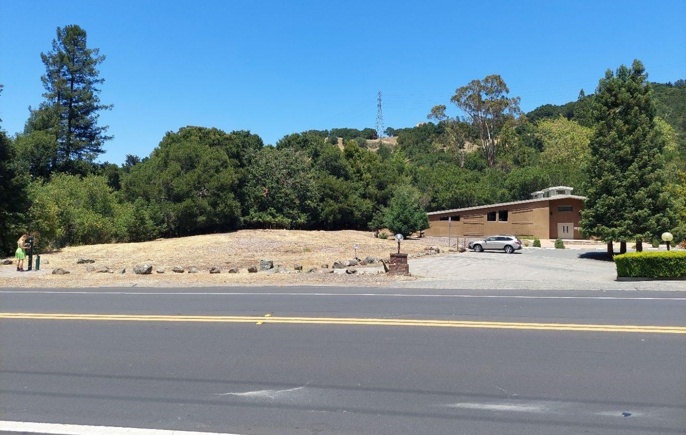
Environmental Impact Analysis Aesthetics Draft Environmental Impact Report 4.1-3
Figure 4.1-4 Miramonte High School Site (HE-4) View from the Site

Figure 4.1-3 St. John Orthodox Church (HE-3) View Southeast from the Site

Figure 4.1-5 Caltrans Gateway (HE-5) View north through the site from California Shakespeare Theater Way
There are four DPP Sites located within this area: Avenida de Orinda (DPP-6), 10 Avenida deOrinda (DPP-7), 20 Avenida de Orinda (DPP-8), and 23 Avenida de Orinda (DPP-9). This area can be characterized by its European “village” architecture as shown in Figure 4.1-6. The architecture can be characterized by the one and two-story buildings that are tightly grouped together. Views of the hillsides from this area are largely limited between buildings due to the proximity of the buildings to one another. Street trees and the European village buildings largely influence the pedestrian-level views of this area.
The following sections give a visual example of the existing design districts as defined in the current Downtown Design Guidelines where Housing Sites are proposed within the DPP Plan Area.
City
Village District North of Camino Sobrante

Downtown Precise Plan
Topography in the DPP Plan Area is generally level or gently rolling. Distant views of hillsides and mature trees can be observed throughout the Plan Area. State Route (SR) 24 and the Orinda Bay Area Rapid Transit (BART) station visually divide the Plan Area into the Village area to the north and the Crossroads area to the south. Development within the DPP has historically been consistent with the characterization established in the City’s General Plan with a “village character” defined as a commercial area of relatively low density with a predominance of small-scale, low-lying buildings of various architectural styles fronting streets or landscaped, plaza-like spaces.
The Plan Area has been developed with a variety of architectural styles including early California mission, ranch, art deco, traditional and contemporary themes dating from the 1920s. A degree of consistency is evident with one- or two-story buildings with pedestrian scale and subdued exterior colors in a dominant landscape setting (City of Orinda 1990).
of Orinda Plan Orinda 4.1-4
Village District South of Camino Sobrante, West of Orinda Way
Environmental Impact Analysis Aesthetics Draft Environmental Impact Report 4.1-5
Examples of DPP Sites located in this area include: 200 Orinda Way (DPP-47) and 9 Altarinda Road (DPP-18). This area can be characterized by the contemporary architecture style with one and two-story buildings. Due to the limited height of the buildings and the large parking lots in this area, extended views of the distant, maturely vegetated hillsides are present as shown in Figure 4.1-7 Thebuildings in this area are also screened by mature trees and vegetation and setback from the street as shown in Figure 4.1-8
Image taken looking east toward Avenida de Orinda
Figure 4.1-6 View of Development in the Village District – North of Camino Sobrante

Figure 4.1-8 View of Development in the Village District – South of Camino Sobrante
Figure 4.1-7 View of Development in the Village District - South of Camino Sobrante
4.1-6
View through 200 Orinda Way looking toward Camino Pablo

City of Orinda Plan Orinda
View of 9 Altarinda Road looking north from Altarinda Road Theatre District and South of State Route 24
Examples of DPP Sites located within this area include: 2 Bates Boulevard (DPP-25), 96 Davis Road(DPP-30), 140 Brookwood Road (DPP-34), and 6 Camino Pablo (DPP-14). This area can be characterized by its traditional and contemporary ranch style buildings. The general height of the

Environmental Impact Analysis Aesthetics Draft Environmental Impact Report 4.1-7
View of 2 Bates Boulevard looking south
Figure 4.1-10 View of the Theatre District
View looking east on Brookwood Road
buildings is one- to two stories. The eastern area, south of SR 24, has a sloping elevation and residential buildings with shrubbery and mature trees partially screening buildings as shown in Figure 4.1-9. The area south of Brookwood Road has a flat elevation and buildings in tight proximity along roadways such as Moraga Way as shown in Figure 4.1 10. Due to the proximity of buildings, views of distant hills are largely interrupted by built elements within this area

Figure 4.1-9 View of Development in the Theatre District and South of SR 24

The California Department of Transportation (Caltrans) manages the State Scenic Highway Program. The program was created in 1963 with the goal of protecting the aesthetic significance of scenic highways throughout the state. According to the State Streets and Highways Code (Sections 260 through 263), a highway may be designated as scenic based on its scenic quality, how much of the natural landscape can be seen by travelers, and the extent to which development intrudes on the traveler’s enjoyment of the view. The California Scenic Highway Program’s Scenic Highway System List identifies scenic highways that are either eligible for designation or have already been designated as such within Contra Costa County. There is one officially designated scenic highway in Contra Costa County that extends through Orinda along SR 24 from the Alameda County Line (Caltrans 2022).
CEQA Statute 21099(d) states that “aesthetic impacts of a residential, mixed use residential, or employment center project on an infill site within a transit priority area 1 shall not be considered significant impacts on the environment. ”
Policy E: Residential Area Design and House siting: Consider ordinances to maintain semi rural character with respect to the following: Regulating the relationship of house size in relation to lot size to maintain low density character; Removal of natural vegetation; Disturbance of existing groundforms; Disturbance of creek corridors; Street design to avoid wide, straight streets; House placement in relation to ridgelines to avoid or minimize visibility around designated ridges and scenic hillsides through the adoption of an appropriate hillside and ridgeline ordinance giving due consideration to such ordinances from adjoining cities; Height of new houses and additions; Solar orientation of new houses.
a. State CaliforniaRegulationsScenicHighway Program
Regulatory Setting
City of Orinda Plan Orinda 4.1.24.1-8
Public Resources Code Section 21099(d)
b. Local Regulations
The General Plan includes goals and policies to support cohesive community design and enhance the visual quality of neighborhoods in the city.
Land Use Implementing Policies
1 Pursuant to CEQA Statute Section 21099(a)(7), a transit priority area is an area within one half mile of an existing major transit stop. BART stations are considered to be major transit stops.
The Land Use and Circulation Element describes the community and neighborhood character where single family residential land uses generally occupy the northern and southern parts of the city with multi family residential, business and professional offices, and downtown land uses occupying the central part of the city along SR 24.
City of Orinda General Plan Land Use and Circulation Element
Circulation Implementing Policies
3. Highway 24, designated as a California Scenic Highway within Orinda City limits.
2. Camino Pablo from its intersection with Santa Maria Way north to the City limits;
Policy P: The following routes are designated Scenic Corridors in the General Plan:
Environmental Impact Analysis Aesthetics Draft Environmental Impact Report 4.1-9
Policy B: Development shall occur only if it meets the following conditions:
1. Development shall meet high quality standards and be consistent with the semi rural and village character of Orinda.
Gateway Valley Guiding Policies
Policy F: Develop a beautification plan for downtown to enhance the visual quality of the streetscape and creek area, including guidelines for public improvements such as landscaping, tree grate design, outdoor lighting, tree planting, and street furniture.
Policy G: Public parking structures are a permitted land use in the downtown provided that they are adequately screened from public view.
City of Orinda Hillside & Ridgeline Design Guidelines
Policy A: Enhance architectural compatibility in each sector of downtown by establishing design districts that provide guidelines and a review process for site layouts, architectural design, alterations, landscaping, and signs. Sloping roofs are encouraged on new buildings in districts where such features are common.
Downtown Implementing Policies
Policy B: Require planting and maintenance of trees and other plant material throughout downtown, according to a comprehensive landscape plan.
3. Development shall be consistent with and significantly assist in the improvement of the Gateway Boulevard interchange, as appropriate.
The purpose of the City’s Hillside and Ridgeline Design Guideline booklet is to communicate the kind of character and environmental sensitivity that the community wishes to achieve with the development of residences on the hillsides and ridgelines of Orinda. The guidelines contain directions regarding preferred building siting, grading, drainage, roadway and driveway, utility line and trench installation, architecture, and landscaping practices that influence the development of residences that preserve the semi rural small town atmosphere of current development (City of Orinda 1988).
1. Moraga Way from its intersection with Camino Pablo south to the City limits;
2. Development must not impose a fiscal burden on Orinda and should yield revenues exceeding public capital and service costs.
Policy C: Enact regulations that will ensure small scale low lying buildings by limiting height to 35 feet (generally not more than two stories) and total floor area to a limited percent of lot area.
Lighting standards should not exceed 16 feet in height, and should be of a design which coordinates with the building architectural style and period. Any light source over 10 feet high should incorporate a cut off shield to prevent the light source from being directly visible from off site areas.
When seen from the outside, the lighting of interior spaces should not brightly contrast with adjacent buildings.
For purposes of this analysis, light refers to light emissions (brightness) generated by a source of light. Stationary sources of light include exterior parking lots and building security lighting; moving sources of light include the headlights of vehicles driving on roadways. Streetlights and other security lighting also serve as sources of light in the evening hours.
Only low level indirect lighting should be used adjacent to residential properties. The level of lighting and location of light source should not result in glare toward residential areas.
As a part of Plan Orinda, the City would adopt the Objective Design Standards which would implement the vision of the Downtown Precise Plan. California State law defines objective design standards as those that “involve no personal or subjective judgement by a public official and are uniformly verifiable by reference to an external and uniform benchmark or criterion available and
Light and Glare
Downtown Design Guidelines related to light and glare are as follows:
Many of the DPP Housing Sites are located in these Design Districts and in the downtown area as shown in Figures 2 4 and 2-5 in Section 2, Project Description.
The Downtown Design Guidelines are intended for use by the City Staff and Planning Commission to reference during the Site Design Review process to evaluate projects. To preserve this diversity and promote visual coordination, the Guidelines are intended to maintain the individuality of each Design District by encouraging compatibility between the buildings of each of the 11 Downtown Design Districts. The Downtown Design Guidelines provides three categories of design guidelines and standards: Overall Downtown Guidelines, Building Enhancement Standards, and Specific Guidelines (City of Orinda 1990). The Overall Downtown Guidelines apply to the entire downtown area defined by the General Plan Land Use map and involve site planning, parking and circulation, architecture, signs, lighting, and landscaping (City of Orinda 2005). The Building Enhancement Standards are applicable to existing building improvements. The Specific Guidelines are specific to each Design District and involve specification of architectural style, building height and bulk, materials, colors, setbacks, and other aspects which vary from District to District.
Downtown Design Guidelines
City of Orinda Plan Orinda 4.1-10
In designated commercial districts, accent lighting for buildings and landscaping should be designed to enhance the night time atmosphere.
Parking areas should be designed and landscaped to minimize summer glare and the visual impact of large numbers of vehicles.
Glare is defined as focused, intense light emanated directly from a source or indirectly when light reflects from a surface. Daytime glare is caused in large part by sunlight shining on highly reflective surfaces at or above eye level. Reflective surfaces area associated with buildings that have expanses of polished or glass surfaces, light colored pavement, and the windshields of parked cars.
Downtown Precise Plan Objective Design Standards (Draft)
Section 30 of the City’s Zoning Ordinance (Orinda Municipal Code Chapter 17) stipulates the requirements of design review, including site plan and architectural review for single family residential projects, any exterior change of any nonresidential building in a residential district, and any exterior change of a building in the following districts: Residential Medium Density (RM); Downtown Commercial (DC); Downtown Office (DO); Public, Semi public and Utility (PS); Parks and Recreation (PR); Open Space (OS); Planned Development (PD); and Specific Plan (SP). In addition, as specific in Section 17.30.60 through Section 17.30.8, development of very large residences, development on severely sloped lots, severe slopes on lots in the ridgeline and environmental preservation overlay district, and development on a small and narrow lot require special design review and must meet specific requirements to preserve Orinda’s semi rural character. Section 17.30.10 stipulates the requirement that any project in the downtown commercial district and downtown office district shall be required to meet the City of Orinda downtown design guidelines. The review procedure includes review by the Planning Commission or Zoning Administrator to determine if project design complies with the standards outlined in Chapter 17.30.
City of Orinda Zoning Ordinance
The City’s Zoning Ordinance (Orinda Municipal Code Chapter 17) specifies building design standards and site development standards for each of the zoning districts.
Objective Design Standards would apply to the entirety of the DPP boundary except sites in the Public, Semi Public and Utility zoning district and sites in the Residential Medium Density zoning district. These standards would apply to development within the area when there would be new construction, additions to existing structures as defined in the Orinda Municipal Code Title 17, and for non conforming structures and uses as described in Chapter 17.19 of the Orinda Municipal Code.
City of Orinda Municipal Code
As described in Orinda Municipal Code Section 17.30.1, Orinda’s Design Review process is intended to preserve and enhance the semi rural nature of Orinda, maintain property values, conserve and enhance the visual character of the community and protect the public health, safety and general welfare of its citizens.
Environmental Impact Analysis Aesthetics Draft Environmental Impact Report 4.1-11
knowable by both development applicant and public official prior to submittal.”(Government Code Section 65913.4(5)). These standards would govern the physical form, character and uses of private development as well as public realm elements such as civic spaces.
Section 22 of the City’s Zoning Ordinance (Orinda Municipal Code Chapter 17) applies general principles to the process of view preservation to address obstruction of views by trees This section defines views within the city as including, but not limited to distinctive geologic features, hillside terrains, wooded canyons, ridges, and bodies of water. Examples include Mount (Mt.) Diablo, prominent features of the East Bay Hills, such as Round Top, Huckleberry Preserve and Tilden Park, Briones Reservoir, and Briones Agricultural Preserve. Scenic views as defined in this section are used throughout this analysis to determine potential impacts to scenic views.
Section 25 of the City’s Zoning Ordinance (Orinda Municipal Code Chapter 17) establishes the preservation, protection, perpetuation, enhancement and use of sites, buildings, structures, trees, works of art and other objects that have a special historical or architectural value. In particular Section 17.25.2(f) and (g) specify goals related to aesthetics to “Preserve and encourage varied architectural styles reflecting various periods of Orinda's history” and to “Protect scenic and historic trees which singularly exemplify the outstanding natural character of Orinda.”
Have a substantial adverse effect on a scenic vista; Substantially damage scenic resources, including but not limited to, trees, rock outcroppings, and historic buildings within a state scenic highway;
Impact Analysis


The following section discusses the CEQA Guidelines Appendix G thresholds for aesthetics impacts.
City of Orinda Plan Orinda 4.1.34.1-12
CEQA Significance Thresholds
In non urbanized areas, substantially degrade existing visual character or quality of public views of the site and its surroundings? If the project is in an urbanized area, would the project conflict with applicable zoning and other regulations governing scenic quality? or;
Impact AES-1 DEVELOPMENT FACILITATED BY THE PROJECT WOULD OCCUR IN DIFFERENT AREAS OF THE CITY INCLUDING ALONG A SCENIC CORRIDOR (MORAGA WAY). HOWEVER, NEW DEVELOPMENT WOULD NOT BLOCK EXPANSIVE VIEWS OR SUBSTANTIALLY IMPEDE ACCESS TO LONGER-RANGE VIEWS OF THE LANDSCAPE. IMPACTS WOULD BE LESS THAN SIGNIFICANT.
The following thresholds of significance are based on CEQA Guidelines Appendix G. For purposes of this EIR, implementation of the proposed project may have a significant adverse impact if it would do any of the following:
Housing Element Update
Housing Element Sites HE 1 through HE-4 are located along Moraga Way, which is a designated scenic corridor within the City of Orinda because of its tree lined roadway. However, Moraga Way does not generally offer views of scenic vistas from the roadway due to existing trees, topography and buildings. Development on these sites would result in more intense development and could result in structures with greater massing than existing development on the sites, but would not substantially block expansive views of scenic vistas within the surrounding area Depictions of the maximum heights of Housing Element Sites HE 1 through HE-4 are shown below in Figure 4.1 11 through Figure 4.1 14
For the purposes of this analysis, a scenic vista is a view from a public place (roadway, designated scenic viewing spot, etc.) that is expansive and considered important by a jurisdiction or a community. It can be obtained from an elevated position (such as from the top of a hillside) or it can be seen from a roadway with a longer range view of the landscape. An adverse effect would occur if a proposed project would substantially block or otherwise damage a scenic vista upon implementation. Scenic vistas in Orinda include ridgelines and hills including Mount Diablo, Round Top, Huckleberry Preserve, and Tilden Park Scenic corridors within the city include Moraga Way and Camino Pablo. The City of Orinda has also identified its hillsides with densely covered trees as attractive visual features of the city.
Threshold: Would the project have a substantial adverse effect on a scenic vista?
Create a new source of substantial light or glare that would adversely affect day or nighttime views in the area.
Figure 4.1 12 Maximum Height of Potential Development on Housing Element Site HE-2 looking from Moraga Way
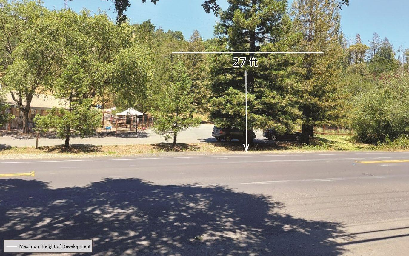

Environmental Impact Analysis Aesthetics Draft Environmental Impact Report 4.1-13
Figure 4.1-11 Maximum Height of Potential Development on Housing Element Site HE-1 looking from Moraga Way
Figure 4.1 14 Maximum Height of Potential Development on Housing Element Site HE-4 looking from Moraga Way


City of Orinda Plan Orinda
4.1-14
Figure 4.1-13 Maximum Height of Potential Development on Housing Element Site HE-3 looking from Moraga Way
Figure 4.1-15 Maximum Height of Potential Development on Housing Element Site HE-5 looking from California Shakespeare Theater Way
Downtown Precise Plan
Environmental Impact Analysis Aesthetics Draft Environmental Impact Report 4.1-15
However, Housing Element Site HE 5 directly abuts state scenic highway SR 24. From SR 24, views of Housing Element Site HE-5 are substantially obscured by existing trees and topography. There is some potential for glimpses of development facilitated by the project on Housing Element Site HE 5 to be visible from Wilder Road and from the SR 24 off ramp onto California Shakespeare Theater Way over intervening topography and through trees; however, potential projects would not substantially block expansive views of scenic vistas
Development facilitated by the project within the DPP Plan Area, and within a transit priority area, would occur primarily on Moraga Way and Camino Pablo, two identified scenic corridors within the city. Current development along these corridors consists of a “village” like development, consistent with the City’s current aesthetic. The area is developed with retail, restaurant, commercial, office, and public uses with buildings reaching height maximums of 35 feet. Most of the DPP sites are located within a transit priority area as defined above in Section 4.1.2, Regulatory Setting. As such,
Housing Element Site HE-5 is not located on a designated scenic corridor as identified by the City, nor would development obscure views of a scenic vista. Views of Housing Element Site HE 5 and its maximum height from directly across California Shakespeare Theater Way are shown in Figure 4.1 15.

DPP 6 Avenida de Orinda 0.7
However, twelve DPP sites located in the northernmost area of the DPP Plan Area would be just outside of the one half mile radius for a transit priority area. The DPP sites and their distance from the Orinda BART station are listed in Table 4.1-1
DPP-44 27 Orinda Way (northern portion of the site) 0.7
DPP-46 61 Orinda Way 0.7
DPP-47 200 Orinda Way 0.6
Development within the DPP Plan Area would largely be infill and would increase heights to 45 feet and 55 feet on sites listed in Table 2.4 and shown in Figure 2-8, Section 2, Project Description
Although building heights would be higher on some sites, views of scenic vistas through the DPP Plan Area are currently obstructed by intervening development and mature landscaping, including creek vegetation which screens views from Camino Pablo Expansive views are already limited by existing development and mature trees. Scenic vistas are currently sparsely available from public viewing areas and development facilitated by the project would not substantially reduce public views of scenic vistas.
Mitigation Measures
Table 4.1-1 Non Transit Priority Area DPP Housing Element Sites
Significance after Mitigation
DPP-9 23 Avenida de Orinda 0.7
DPP-28 112 Camino Pablo 0.8
City of Orinda Plan Orinda
DPP-10 63 Orinda Way 0.7
Site #
Impacts would be less than significant without mitigation.
DPP-7 10 Avenida de Orinda 0.7
aesthetic impacts related to development of the DPP Sites within a transit priority area would be less than significant in compliance with Public Resources Code Section 21099(d).
DPP-12 115 Orinda Way 0.8
Distance from Orinda BART Station (miles)
In summary, development facilitated by Plan Orinda would occur primarily in existing developed neighborhoods where long range and expansive views are generally not available through the housing sites due to existing topography, trees and development, and would not substantially adversely affect views of the hillside areas or other scenic vistas.
DPP-11 79 Orinda Way 0.8
4.1-16
No mitigation measures would be required.
DPP-8 20 Avenida de Orinda 0.7
Location
DPP-45 31 Orinda Way 0.6
Housing Element Update
Threshold: Would the project substantially damage scenic resources, including but not limited to, trees, rock outcroppings, and historic buildings within a state scenic highway?
The DPP would allow for the addition of residential development to commercial/office uses within this area; however, height limits would remain 35 feet north of SR 24 with some allowances of up to
Downtown Precise Plan
Implementation of Mitigation Measure AES 1 would reduce impacts related to removal of trees within view of the SR 24 off ramp.
Environmental Impact Analysis Aesthetics Draft Environmental Impact Report 4.1-17
Impact AES-2 HOUSING ELEMENT SITE HE-5 AND DPP SITES ARE VISIBLE FROM SR 24, AN OFFICIALLY DESIGNATED STATE SCENIC HIGHWAY. HOWEVER, WITH THE EXCEPTION OF HOUSING ELEMENT SITE HE-5, DEVELOPMENT FACILITATED BY THE PROJECT WOULD NOT RESULT IN SUBSTANTIAL DAMAGE TO SCENIC RESOURCES IN VIEW OF A SCENIC HIGHWAY. IMPACTS FROM DEVELOPMENT ON HOUSING ELEMENT SITE HE-5 WOULD BE LESS THAN SIGNIFICANT WITH MITIGATION.
Development facilitated by the project would primarily be located in the southern portion of the city. Housing Element Sites HE 1 through HE 4 are not visible from SR 24, which is the only state scenic highway in the vicinity of Orinda. Due to the sites’ distance from SR 24 and intervening structures and landscape, development on Housing Element Sites HE 1 through HE 4 would not result in significant impacts related to damaging scenic resources visible from a state scenic highway. However, Housing Element Site HE-5 directly abuts SR 24 Although the site is not entirely visible from a state scenic highway, there is the potential that motorists on Wilder Road and the SR 24 off ramp to California Shakespeare Theater Way would catch brief glimpses over existing topography and through existing tall trees of future development on the site Development of Housing Element Site HE 5 could involve removal of mature trees from the site to accommodate future development Protected trees that would be removed as a result of development facilitated by the project would be required to be replaced by the project applicant in compliance with Orinda Municipal Code Section 17.21.8. However, not all trees that would be removed would be considered protected trees. This would be a significant impact and mitigation would be required.
Development facilitated by the project on Housing Element Site HE 5 would be subject to design review pursuant to Orinda Municipal Code Chapter 17.30 prior to construction and would be required to comply with the City of Orinda General Plan policies listed in Section 4.1.2, Regulatory Setting regulating the size and locations of housing. Compliance with design review standards and General Plan policies would reduce potential impacts to scenic resources such as trees and rock outcroppings on Housing Element Site HE-5 Nevertheless, development of Site HE 5 could result in potentially significant impacts regardless of compliance with Orinda Municipal Code and the City of Orinda’s General Plan.
There is one known historical resource within proximity of SR 24: Orinda Theatre and American Trust Bank Building at 2 Theatre Square (DPP 79), which is listed as eligible in the National Register of Historic Places and California Register of Historic Resources and is visible from SR 24 (See Section 4.4, Cultural Resources). Additionally, two properties designated as Orinda Historical Landmarks are located on DPP Public Service Sites: Orinda Community Center/Orinda Union School and the Orinda Sign, both at 26 Orinda Way (DPP 87); and Orinda Sign 1892 Santa Maria Church Bell at 20 Santa Maria Way (DPP 88), distantly visible from SR 24. Plan Orinda does not envision the demolition or alteration of these identified historical sites
Development along SR 24 would also be subject to the Orinda Downtown Design Guidelines and its design requirements. Design standards would differ based on which zone a parcel would be within. Each zone would regulate the physical form, character, and use of development. Further, development facilitated by the project would also be subject to design review pursuant to Orinda Municipal Code Chapter 17.30 prior to construction Regulation of the design of structures would ensure that the development within the DPP Plan Area would be designed so that trees and historic structures would remain visible from state scenic highways where currently available. Compliance with the Objective Design Standards applicable to zoning and design review would reduce potential impacts to scenic resources such as trees, designated historic buildings, rock outcroppings or other resources Development facilitated by the project in the DPP Plan Area would not damage scenic resources, including but not limited to, trees, rock outcroppings, and historic buildings within a state scenic highway, and impacts would be less than significant.
Implementation of the project would facilitate change along a state scenic highway and potentially within view of its off ramp. However, development would be required to comply with applicable design standards, policies, and municipal code to reduce impacts. With implementation of Mitigation Measure AES 1, impacts would be further reduced to less than significant levels
City of Orinda Plan Orinda 4.1-18
Significance after Mitigation
55 feet along Camino Pablo. Heights would primarily remain limited to 35 feet south of SR 24 with some allowances for height limits to reach 45 feet. An increase of 10 feet from current maximums would not substantially limit views from SR 24 of historic buildings as such buildings would remain visible despite potential increases in height. The Orinda Theatre sign visible from SR 24 would also remain visible, albeit less of the sign would be visible due to the increase in heights. While some sites may be seen while vehicles travel along SR 24, views of the Orinda Theatre sign and other identified historic properties would be briefly interrupted but would not be entirely blocked by the increase in heights along SR 24 Protected trees that would be removed as a result of development facilitated by the project within view of a state scenic highway would be required to be replaced by project applicants in compliance with Orinda Municipal Code Section 17.21.8. However, not all trees that would be removed would be considered protected trees. As such, implementation of Mitigation Measure AES 1 would be required to reduce impacts related to trees within view of a state scenic highway. There are no rock outcroppings located in the DPP Plan Area. There would be no damage to rock outcroppings within view of a state scenic highway.
AES-1 City of Orinda Objective Design Standards
The City, with the guidance of a qualified urban design firm, shall develop and adopt objective design standards for the Plan Orinda area similar to the City’s current Senior Housing Overlay standards prior to development of the Housing Element sites. Objective Design Standards shall include guidance including but not limited to structure design, massing, intensity, lighting, and landscaping. For the Housing Element sites, the Objective Design Standards shall require tree planting or other screening measures to ensure that the general aesthetic of Orinda’s roadways would not be substantially adversely affected by the project.
Mitigation Measure
Environmental Impact Analysis Aesthetics Draft Environmental Impact Report 4.1-19
Threshold: Would the project, in non urbanized areas, substantially degrade the existing visual character or quality of public views of the site and its surroundings? (Public views are those that are experienced from a publicly accessible vantage point). If the project is in an urbanized area, would the project conflict with applicable zoning and other regulations governing scenic quality?
Proposed Objective Design Standards applicable to the DPP Plan Area would regulate the design, massing, and form of new development and would ensure new development would not substantially degrade the visual character or quality of the city Development within the DPP Plan Area would change the nature of land uses to include more dense and diverse types of land uses in some locations including higher intensity residential, office, and commercial development to adapt the style of new construction to a more pedestrian oriented design model while maintaining the city’s semi rural and village feel. Implementation of current design guidelines through design review pursuant to Orinda Municipal Code Chapter 17.30 would ensure that development would be consistent with existing surrounding development.
Housing Element Update
Implementation of Mitigation Measure AES-1 would ensure that development within the Plan Orinda area would be compliant with objective design guidelines that would reduce impacts to the general aesthetic of the City of Orinda.
Impact AES-3 DEVELOPMENT FACILITATED BY THE PROJECT WOULD HAVE THE POTENTIAL TO CHANGE THE VISUAL CHARACTER OF THE DPP PLAN AREA AND THE FIVE IDENTIFIED HOUSING SITES. HOWEVER, DEVELOPMENT WOULD BE REQUIRED TO COMPLY WITH EXISTING GENERAL PLAN GOALS AND POLICIES, EXISTING APPLICABLE DESIGN GUIDELINES AND, IN THE DPP PLAN AREA, DEVELOPMENT WOULD BE REQUIRED TO COMPLY WITH NEW OBJECTIVE DESIGN STANDARDS. DEVELOPMENT WITHIN A TRANSIT PRIORITY AREA IN THE DPP PLAN AREA PURSUANT TO PUBLIC RESOURCES CODE SECTION 21099(D) WOULD RESULT IN LESS THAN SIGNIFICANT IMPACTS. OVERALL, IMPACTS WOULD BE LESS THAN SIGNIFICANT WITH MITIGATION.
Plan Orinda would facilitate changes in development parameters that would incrementally change the visual character of limited portions of the City of Orinda through the development and redevelopment of specific sites. Development would include infill development and development of previously undeveloped sites or portions of sites. Development of the Housing Element Sites would result in higher intensity residential developments that would be required to adapt the style of new construction while maintaining the city’s semi rural and village feel. Implementation of current design guidelines through design review pursuant to Orinda Municipal Code Chapter 17.30 would ensure that development would be consistent with existing surrounding development. As noted above under Impact AES 1, Housing Element Sites HE 1 through HE 3 are located along Moraga Way, which is a designated scenic corridor because of its tree lined roadway. Development on these sites would result in more intense development and could result in structures with greater massing than existing development on the sites, which may affect the visual quality of the corridor.
Downtown Precise Plan
Development within the DPP Plan Area would also be subject to the proposed Objective Design Standards intended to enhance the downtown area’s village feel while allowing for greater intensities in development. Plan Orinda would allow for an increase in height and density but would also require that all projects conform to design standards and policies that ensure high quality
Mitigation Measure AES 1 would require tree planting on these sites to ensure that the general aesthetic of Moraga Way would not be substantially adversely affected by the project.
As described in Section 4.1.1, Setting, the Plan Area is defined as being semi rural. As such, lighting within the Plan Area is generally low to moderate. Development facilitated by the project, however, would occur in already urbanized areas of Orinda, where existing lights and surfaces with glare are common. Housing Element Sites and DPP sites are located on currently developed sites with some level of lighting. However, new development on Housing Element Sites HE 4 and HE 5 would introduce new sources of light and glare where there were previously none. All lighting from development facilitated by the project would be subject to compliance with Orinda Municipal Code Section 17.15.2(C)(2) which requires that outdoor lighting be shielded or directed away from residential districts. Glare from development facilitated by the project would be subject to compliance with Orinda Municipal Code Section 17.15.2(C)(1) which requires that mirrored or highly reflective glass may not cover more than 20 percent of a building surface visible from a street. Further, while development facilitated by the project would introduce new sources of light and glare due to the addition of residences with outdoor lighting, windows and vehicles, and new light and glare sources at Housing Element Sites HE 4 and HE 5, development would be required to undergo design review prior to construction which could result in additional conditions related to light and glare for development. Further, implementation of Mitigation Measure AES-1, which would include design standards for lighting, would reduce impacts related to light and glare within the Plan Orinda
architectural and site design that would create a sense of place and increase visual quality but maintain the city’s semi rural feel. Landscaping plans for development facilitated by the project would also be required to comply with Mitigation Measure AES 1 to reduce potential impacts to scenic quality as a result of altered vistas along scenic corridors and with frontage to City of Orinda Forroadways.development
Mitigation Measure
within the DPP Plan Area that would be located within a transit priority area, aesthetic impacts would be less than significant. For development outside of a transit priority area facilitated by the project, development would not substantially degrade visual quality. Impacts would be less than significant with mitigation.
Impact AES-4 NEW DEVELOPMENT FACILITATED BY THE PROJECT WOULD RESULT IN NEW SOURCES OF LIGHT AND GLARE. HOWEVER, NEW DEVELOPMENT WOULD PRIMARILY OCCUR IN ALREADY DEVELOPED AREAS WHERE NEW LIGHT AND GLARE WOULD BE GENERALLY CONSISTENT WITH EXISTING CONDITIONS. WHERE DEVELOPMENT WOULD RESULT IN NEW SOURCES OF LIGHT AND GLARE, IT WOULD BE SUBJECT TO DESIGN REVIEW AND RELEVANT ORINDA MUNICIPAL CODE PROVISIONS THAT WOULD REDUCE POTENTIAL IMPACTS. IMPACTS WOULD BE LESS THAN SIGNIFICANT WITH MITIGATION.
Development facilitated by the project would have the potential to change the visual character of the city. However, development would be required to comply with applicable design standards, policies, and municipal code to reduce impacts. With implementation of Mitigation Measure AES 1, impacts would be further reduced to less than significant levels.
Significance after Mitigation
City of Orinda Plan Orinda 4.1-20
Mitigation Measure AES 1 would be required.
Threshold: Would the project create a new source of substantial light or glare that would adversely affect daytime or nighttime views in the area?
Mitigation Measure
area. Design review of development would ensure that nighttime light pollution and off site lighting and glare impacts would be minimized.
Compliance with applicable regulations would reduce impacts from new sources of substantial light or glare which would adversely affect day or nighttime views within the city. Impacts would be less than significant with mitigation
Development facilitated by the project in conjunction with other nearby past, present and reasonably foreseeable future projects in the region could result in impacts to visual resources and aesthetic quality. Implementation of Plan Orinda would encourage increased housing development on key sites and primarily within the DPP Plan Area. Most projects in the city, adjacent cities, and Contra Costa County would be required to undergo analysis for impacts to aesthetics and visual resources. These impacts would be mitigated by design guidelines, regulations, policies, and project specific mitigation measures, thereby limiting damage to existing visual resources and enhancing the visual quality of areas where development occurs. Consequently, development facilitated by the project would not result in significant cumulative environmental impacts in conflict with requirements for preserving scenic vistas, scenic resources in State- or locally designated highways or drives, visual quality, and for limiting the effects of light and glare. Therefore, plan implementation would not considerably contribute to a significant cumulative impact on aesthetics and no mitigation would be required.
Significance after Mitigation
Development within the DPP Plan Area would also be subject to the Downtown Design Guidelines listed above in Section 4.1.2, Regulatory Setting.
Implementation of Mitigation Measure AES-1 would be required.
Development facilitated by the project would have the potential to introduce new sources of light and glare within the Plan Orinda area. However, development would be required to comply with applicable design standards, policies, and municipal code to reduce impacts. With implementation of Mitigation Measure AES-1, impacts would be further reduced to less than significant levels.
Environmental Impact Analysis Aesthetics Draft Environmental Impact Report 4.1-21
4.1.4 Cumulative Impacts
A project’s environmental impacts are “cumulatively considerable” if the “incremental effects of an individual project are significant when viewed in connection with the effects of past projects, the effects of other current projects, and the effects of probable future projects” (CEQA Guidelines Section 15065(a)(3)). The geographic scope for cumulative aesthetics impacts includes development facilitated by Plan Orinda within the City of Orinda. This geographic scope is appropriate for aesthetics because intervening topography and buildings limit the extent of views of scenic areas; and lighting and glare generally affects adjacent properties. Due to the programmatic nature of Plan Orinda, a project level cumulative analysis is not possible. Cumulative impacts to the aesthetics of the City would derive from visible changes envisioned under Plan Orinda and anticipated development facilitated by it.
City of Orinda Plan Orinda 4.1-22
This page intentionally left blank
The City of Orinda is in the San Francisco Bay Area Air Basin (SFBAAB), which is under the jurisdiction of the Bay Area Air Quality Management District (BAAQMD). The SFBAAB includes the counties of San Francisco, Santa Clara, San Mateo, Marin, Napa, Contra Costa, and Alameda, along with the southeast portion of Sonoma County and the southwest portion of Solano County. Air quality in these basins is affected by the region’s emission sources and by natural factors. Topography, wind speed and direction, and air temperature gradient all influence air quality. The SFBAAB has a Mediterranean climate, with warm, dry summers and cool, damp winters.
Air Quality Pollutants of Primary Concern
Local Climate and Meteorology
Environmental Impact Analysis Air Quality and Greenhouse Gas Emissions Draft Environmental Impact Report 4.2-1
4.2.1 Air Quality Setting
4.2 Air Quality and Greenhouse Gas Emissions
a. Existing Air Quality Setting
Ozone
This section analyzes the potential air quality and greenhouse gas (GHG) emissions impacts associated with the implementation of Plan Orinda.
Ozone is produced by a photochemical reaction (i.e., triggered by sunlight) between nitrogen oxides (NOX) and reactive organic gases (ROG). 1 NOX is formed during the combustion of fuels, while ROG is formed during combustion and evaporation of organic solvents. Because ozone requires sunlight to form, it mostly occurs in substantial concentrations between the months of April and October. Ozone is a pungent, colorless, toxic gas with direct health effects on humans including respiratory and eye irritation and possible changes in lung functions. Groups most sensitive to ozone include children, the elderly, people with respiratory disorders, and people who exercise strenuously outdoors.
1 CARB defines VOC and ROG similarly as, “any compound of carbon excluding CO, carbon dioxide, carbonic acid, metallic carbides or carbonates, and ammonium carbonate,” with the exception that VOC are compounds that participate in atmospheric photochemical reactions (CARB 2009). For the purposes of this analysis, ROG and VOC are considered comparable in terms of mass emissions and the term ROG is used in this report.
The federal and State clean air acts mandate the control and reduction of certain air pollutants. Under these laws, USEPA and CARB have established ambient air quality standards for certain criteria pollutants. Ambient air pollutant concentrations are affected by the rates and distributions of corresponding air pollutant emissions, and by the climate and topographic influences discussed above. Proximity to major sources is the primary determinant of concentrations of non reactive pollutants, such as CO and suspended particulate matter. A discussion of each primary criterion pollutant is provided below.
Carbon Monoxide
CO is an odorless, colorless gas and causes health problems such as fatigue, headache, confusion, and dizziness. The incomplete combustion of petroleum fuels by on road vehicles and at power plants is a major cause of CO, which is also produced during the winter from wood stoves and
levels usually follow the spatial and temporal distributions of vehicular traffic. Localized CO “hotspots” can occur at intersections with heavy peak hour traffic. Specifically, hotspots can be created at intersections where traffic levels are sufficiently high that the local CO concentration exceeds the NAAQS of 35.0 ppm or the CAAQS of 20.0 ppm.
NO2 is a by product of fuel combustion, with the primary source being motor vehicles and industrial boilers and furnaces. Nitric oxide is the principal form of nitrogen oxide produced by combustion, but nitric oxide reacts rapidly to form NO2, creating the mixture of NO and NO2 commonly called NOX. Nitrogen dioxide is an acute irritant. A relationship between NO2 and chronic pulmonary fibrosis may exist, and an increase in bronchitis may occur in young children at concentrations below 0.3 ppm. Nitrogen dioxide absorbs blue light and causes a reddish brown cast to the atmosphere and reduced visibility. It can also contribute to the formation of PM10 and acid rain.
Lead
Suspended Particulate Matter
fireplaces. CO tends to dissipate rapidly into the atmosphere; consequently, violations of the State CO standards are associated generally with major roadway intersections during peak hour traffic Ambientconditions.CO
City of Orinda Plan Orinda 4.2-2
Nitrogen Dioxide
PM10 is particulate matter measuring no more than 10 microns in diameter; PM2.5 is fine particulate matter measuring no more than 2.5 microns in diameter. Suspended particulates are mostly dust particles, nitrates, and sulfates. Both PM10 and PM2.5 are by products of fuel combustion and wind erosion of soil and unpaved roads and are directly emitted into the atmosphere through these processes. Suspended particulates are also created in the atmosphere through chemical reactions. The characteristics, sources, and potential health effects associated with the small particulates (those between 2.5 and 10 microns in diameter) and fine particulates (those 2.5 microns and below) can be very different.
The small particulates generally come from windblown dust and dust kicked up by mobile sources. The fine particulates are generally associated with combustion processes, and form in the atmosphere as a secondary pollutant through chemical reactions. Fine particulate matter is more likely to penetrate deeply into the lungs and poses a health threat to all groups, but particularly to the elderly, children, and those with respiratory problems. More than half of the small and fine particulate matter inhaled into the lungs remains there. These materials can damage health by interfering with the body’s mechanisms for clearing the respiratory tract or by acting as carriers of an absorbed toxic substance.
Lead is a metal found in the environment and in manufacturing products. Historically, the major sources of lead emissions have been mobile and industrial sources. In the early 1970s, the USEPA set national regulations to gradually reduce the lead content in gasoline. In 1975, unleaded gasoline was introduced for motor vehicles equipped with catalytic converters. The USEPA completed the ban prohibiting the use of leaded gasoline in highway vehicles in December 1995. As a result of the USEPA’s regulatory efforts to remove lead from gasoline, atmospheric lead concentrations have declined substantially over the past several decades. The most dramatic reductions in lead emissions occurred prior to 1990 due to the removal of lead from gasoline sold for most highway vehicles. Because of phasing out leaded gasoline, metal processing is now the primary source of lead
emissions. The highest level of lead in the air is found generally near lead smelters. Other stationary sources include waste incinerators, utilities, and lead acid battery manufacturers.
The California Health and Safety Code defines a toxic air contaminant (TAC) as “an air pollutant which may cause or contribute to an increase in mortality or in serious illness, or which may pose a present or potential hazard to human health.” Most of the estimated health risks from TACs can be attributed to relatively few compounds, the most important being diesel particulate matter (DPM) from diesel fueled engines. According to CARB, diesel engine emissions are believed to be responsible for about 70 percent of California’s estimated known cancer risk attributable to TACs and they make up about 8 percent of outdoor PM2.5 (CARB 2021a).
Environmental Impact Analysis Air Quality and Greenhouse Gas Emissions Draft Environmental Impact Report 4.2-3
The USEPA has set primary National Ambient Air Quality Standards (NAAQS) for ozone, carbon monoxide (CO), nitrogen dioxide (NO2), sulfur dioxide (SO2), particulate matter with an aerodynamic diameter equal to or less than 10 microns (PM10), fine particulate matter with an aerodynamic diameter equal to or less than 2.5 microns (PM2.5), and lead. Primary standards are those levels of air quality deemed necessary, with an adequate margin of safety, to protect public health. In addition, California has established health based ambient air quality standards (CAAQS) for these and other pollutants, some of which are more stringent than the federal standards. Table 4.2-1 lists the current federal and State standards for regulated pollutants.
Table 4.2-1 Federal and State Ambient Air Quality Standards and Attainment Status Pollutant Averaging Time California Standards National Standards Concentration AttainmentStatus Concentration AttainmentStatus Ozone 8 Hour 0.070 ppm N 0.070 ppm N 1 Hour 0.09 ppm N N/A N/A Carbon Monoxide 8 Hour 9.0 ppm A 9 ppm A 1 Hour 20 ppm A 35 ppm A Nitrogen Dioxide 1 Hour 0.18 ppm A 0.100 ppm U Annual Arithmetic Mean 0.030 ppm N/A 0.053 ppm A
Toxic Air Contaminants
Air Quality Standards
As a local air quality management agency, the BAAQMD must monitor air pollutant levels to ensure that State and federal air quality standards are met and, if they are not met, to develop strategies to meet them. Depending on whether standards are met or exceeded, a local air basin is classified as in “attainment” or “non attainment.” The SFBAAB is designated non attainment for the federal standards for ozone and PM2.5 and in non attainment for the State standard for ozone, PM2.5, and PM10.
The federal and state governments have established ambient air quality standards for the protection of public health. The United States Environmental Protection Agency (USEPA) is the federal agency designated to administer air quality regulation, while the California Air Resources Board (CARB) is the State equivalent in the California Environmental Protection Agency (CalEPA). The BAAQMD provides local management of air quality in the City. CARB has established air quality standards and is responsible for the control of mobile emission sources, while the BAAQMD is responsible for enforcing standards and regulating stationary sources.
Annual Arithmetic Mean N/A N/A 0.030 ppm A
The closest air quality monitoring station to the City is the Concord station located at 2975 Treat Boulevard, located approximately 9 miles northeast of the City. The Concord station monitors ozone, CO, NO2, PM2.5, and PM10. Table 4.2-2 indicates the number of days that each of the air quality standards have been exceeded at the stations during the monitoring period from 2018 through 2020. 8 hour ozone exceeded both state and federal thresholds twice in 2019 and three times in 2020. 1 hour ozone exceeded state thresholds twice in 2020. PM2.5 exceeded federal thresholds 15 times in 2018 and 17 times in 2020. PM10 exceeded state thresholds once in 2018 and 2020, and federal thresholds once in 2020. No other thresholds were exceeded in the years 2018 through 2020.
Current Air Quality
Pollutant Averaging Time
informationNoavailable N/A N/A
N/A U N/A N/A
Particulate MatterFine (PM2.5)
Annual Arithmetic Mean 20 µg/m3 N N/A N/A 24 Hour 50 µg/m3 N 150 µg/m3 U
California Standards National Standards Concentration AttainmentStatus Concentration AttainmentStatus
City of Orinda Plan Orinda 4.2-4
Sulfur Dioxide 24 Hour 0.04 ppm A 0.14 ppm A 1 Hour 0.25 ppm A 0.075 ppm A
Particulate Matter (PM10)
Sulfates 24 Hour 25 µg/m3 A N/A N/A
Hydrogen Sulfide 1 Hour 0.03 ppm U N/A N/A Vinyl (chloroethene)Chloride 24 Hour 0.010 ppm
CARB and the U.S. EPA established ambient air quality standards for major pollutants, including ozone, CO, NO2, SO2, lead (Pb), and PM10 and PM2.5. Standards have been set at levels intended to be protective of public health. California standards are more restrictive than federal standards for each of these pollutants except for lead and the eight hour average for CO.
Annual Arithmetic Mean 12 µg/m3 N 12 µg/m3 U/A 24 Hour 35 µg/m3 N
Visibility Reducing particles 8 (10:00Hour to 18:00 PST)
Lead Calendar Quarter N/A N/A 1.5 µg/m3 A Rolling 3 Month Average N/A N/A 0.15 µg/m3 N/A 30 Day Average 1.5 µg/m3 N/A N/A A
A=Attainment N=Nonattainment U=Unclassified; mg/m3=milligrams per cubic meter ppm=parts per million µg/m3=micrograms per cubic Source:meterBAAQMD 2017a, http://www.baaqmd.gov/research and data/air quality standards and attainment status
Residences throughout the city
Number of days of state exceedances (>0.070 ppm) 0 2 3
Number of days of federal exceedances (>0.112 ppm) 0 0 0
Particulate matter <10 microns, µg/m3, 24 hour maximum 105.0 36.0 167.0
1-hour Ozone (ppm), maximum 0.077 0.092 0.108
8-Hour Ozone (ppm), maximum 0.061 0.074 0.083
Childcare centers, preschools, and K 12 schools
Source: CARB 2022a
Number of days of federal exceedances (>100 ppb) 0 0 0
Number of days of state exceedances (>180 ppb) 0 0 0
Number of days of state exceedances (>0.09 ppm) 0 0 2
Environmental Impact Analysis Air Quality and Greenhouse Gas Emissions Draft Environmental Impact Report 4.2-5
Number of days above federal standard (>35 µg/m3) 15 0 17
Number of days of federal exceedances (>150 µg/m3) 0 0 1 ppm = parts per million µg/m3 = micrograms per cubic meter
Senior centers such as the Monteverde Senior Apartments, Orinda Senior Village, Orinda Rehabilitation and Convalescent Hospital (a nursing home), and Lamorinda Adult Respite Center
Nitrogen dioxide (ppb), 1-hour maximum 38.3 40.6 33.9
Number of days of state exceedances (>50 µg/m3) 1 0 1
4.2.2
Greenhouse Gas Setting
Sensitive Receptors
a. Greenhouse Gases
Number of days of federal exceedances (>0.070 ppm) 0 2 3
2018
Health care facilities such as John Muir Health Urgent Care Center and Sutter Health Orinda Care Center
Particulate matter <2.5 microns, µg/m3, 24 hour maximum 180.0 28.2 119.8
Table 4.2-2 Ambient Air Quality at Nearest Monitoring Station Pollutant 2019 2020 Concord Station
Ambient air quality standards have been established to represent the levels of air quality considered sufficient to protect public health and welfare, with a margin of safety. They are designed to protect that segment of the public most susceptible to the effects of air pollutants and subsequent respiratory distress, such as children under 14, the elderly over 65, persons engaged in strenuous work or exercise, and people with cardiovascular and chronic respiratory diseases. The following locations contain sensitive receptors within Orinda:
Gases that absorb and re emit infrared radiation in the atmosphere are called GHGs. The gases widely seen as the principal contributors to human induced climate change include carbon dioxide (CO2), methane (CH4), nitrous oxides (N2O), fluorinated gases such as hydrofluorocarbons (HFCs) and perfluorocarbons (PFCs), and sulfur hexafluoride (SF6). Water vapor is excluded from the list of
a. Federal Regulations
City of Orinda Plan Orinda 4.2-6
2States.TheIntergovernmental
California
Based on the California Air Resource Board’s (CARB) California GHG Inventory for 2000 2018, California produced 425 MMT of CO2e in 2018. Transportation is the major source of GHG emissions in California, contributing 40 percent of the state’s total GHG emissions. The industrial sector is the second largest source, contributing 21 percent of the state’s GHG emissions, and electric power accounts for approximately 15 percent (CARB 2020). California emissions are due in part to its large size and large population compared to other states. In 2016, the State of California achieved its 2020 GHG emission reduction targets as emissions fell below 431 MMT of CO2e (CARB 2020). The annual 2030 statewide target emissions level is 260 MMT of CO2e (CARB 2017).
City of Orinda
The City of Orinda currently does not have a Climate Action Plan and does not have a GHG inventory.
4.2.3 Regulatory Setting
Air Quality
Panel on Climate Change’s (2021) Sixth Assessment Report determined that methane has a GWP of 30. However, the 2017 Climate Change Scoping Plan published by the California Air Resources Board uses a GWP of 25 for methane, consistent with the Intergovernmental Panel on Climate Change’s (2007) Fourth Assessment Report Therefore, this analysis utilizes a GWPs from the Fourth Assessment Report.
Federal Clean Air Act
b. Greenhouse Gas Inventory
Different types of GHGs have varying global warming potentials (GWP). The GWP of a GHG is the potential of a gas or aerosol to trap heat in the atmosphere over a specified timescale (generally, 100 years). Because GHGs absorb different amounts of heat, a common reference gas (CO2) is used to relate the amount of heat absorbed to the amount of the gas emitted, referred to as “carbon dioxide equivalent” (CO2e), which is the amount of GHG emitted multiplied by its GWP. Carbon dioxide has a 100 year GWP of one. By contrast, methane has a GWP of 30, meaning its global warming effect is 30 times greater than CO2 on a molecule per molecule basis (IPCC 2021). 2
GHGs because it is short lived in the atmosphere, and natural processes, such as oceanic evaporation, largely determine its atmospheric concentrations.
The USEPA is charged with implementing national air quality programs. USEPA’s air quality mandates are drawn primarily from the federal Clean Air Act (CAA), passed in 1963 by the U.S. Congress and amended several times. The 1970 federal CAA amendments strengthened previous legislation and laid the foundation for the regulatory scheme of the 1970s and 1980s. In 1977, Congress again added several provisions, including non attainment requirements for areas not meeting NAAQS and the Prevention of Significant Deterioration program. The 1990 federal CAA amendments represent the latest in a series of federal efforts to regulate air quality in the United
Environmental Impact Analysis Air Quality and Greenhouse Gas Emissions Draft Environmental Impact Report 4.2-7
3 Switching electricity generation from fossil fuels to clean sources.
In the most recent West Virginia v. Environmental Protection Agency (20 1530 [2022]), the U.S. Supreme Court held that the USEPA may not regulate emissions from coal- and gas fired power plants using generation shifting 3 that was implemented as part of the 2015 Clean Power Plan. The Court held that the USEPA is not permitted, under the Clean Air Act, to implement regulations for power plants that were allowed under the Clean Power Plan. However, the Court upheld EPA’s authority to continue regulating greenhouse gas emissions from the power sector (Supreme Court 2021).
The U.S. Supreme Court determined in Massachusetts et al. v. Environmental Protection Agency et al. ([2007] 549 U.S. 05 1120) that the USEPA has the authority to regulate motor vehicle GHG emissions under the federal Clean Air Act. The USEPA issued a Final Rule for mandatory reporting of GHG emissions in October 2009. This Final Rule applies to fossil fuel suppliers, industrial gas suppliers, direct GHG emitters, and manufacturers of heavy-duty and off road vehicles and vehicle engines and requires annual reporting of emissions. In 2012, the USEPA issued a Final Rule that established the GHG permitting thresholds that determine when Clean Air Act permits under the New Source Review Prevention of Significant Deterioration and Title V Operating Permit programs are required for new and existing industrial facilities.
National Ambient Air Quality Standards
The federal CAA requires USEPA to establish primary and secondary NAAQS for several criteria air pollutants. The air pollutants for which standards have been established are considered the most prevalent air pollutants known to be hazardous to human health. NAAQS have been established for ozone, CO, NO2, SO2, PM10, PM2.5, and Pb.
In Utility Air Regulatory Group v. Environmental Protection Agency (134 Supreme Court 2427 [2014]), the U.S. Supreme Court held the USEPA may not treat GHGs as an air pollutant for purposes of determining whether a source can be considered a major source required to obtain a Prevention of Significant Deterioration or Title V permit. The Court also held that Prevention of Significant Deterioration permits otherwise required based on emissions of other pollutants may continue to require limitations on GHG emissions based on the application of Best Available Control Technology
Greenhouse Gas
Safer Affordable Fuel Efficient Vehicle Rule
In April 2020, EPA and NHTSA issued the Safer Affordable Fuel Efficient (SAFE) Vehicles Rule, which required automakers to improve fuel efficiency 1.5 percent annually from model years 2021 through 2026. The SAFE rule also upended State emission programs, and withdrew the waiver for California’s Advanced Clean Cars Program, Zero Emission Vehicle Program (ZEV), and Low Emission Vehicle Program (LEV). In response, California and other states sued in federal court to challenge the final action on preemption of state vehicle standards. In April 2021, the Biden administration, USEPA, and Department of Transportation began the process of dropping limitations on California’s waiver. In December 2021, NHTSA issued a repealing of the SAFE Vehicle Rule Part One. In March 2022, USEPA did the same, thereby reinstating California’s waiver and the ability of other states to adopt the California standards (Center for Climate and Energy Solutions [C2ES] 2022).
Federal GHG Emissions Regulation
California Clean Air Act
The California CAA requires CARB to establish ambient air quality standards for California, known as CAAQS. Similar to the NAAQS, CAAQS have been established for criteria pollutants and standards are established for vinyl chloride, hydrogen sulfide, sulfates, and visibility reducing particulates. In general, the CAAQS are more stringent than the NAAQS on criteria pollutants. The California CAA requires all local air districts to endeavor to achieve and maintain the CAAQS by the earliest practical date. The California CAA specifies that local air districts focus attention on reducing the emissions from transportation and area wide emission sources and provides districts with the authority to regulate indirect sources.
As shown in Table 4.2-2, the nearest monitoring stations to the housing sites have shown the area to have relatively clean air Federal and State ozone thresholds have been exceeded five times in three years (2018 2020) and Federal PM2.5 thresholds have been exceeded 32 times in three years (2018 2020)
The California CAA, signed into law in 1988, requires all areas of the State to achieve and maintain the CAAQS by the earliest practical date. CARB is the State air pollution control agency and is a part of CalEPA. CARB is the agency responsible for coordination and oversight of State and local air pollution control programs in California, and for implementing the requirements of the California CAA. CARB overseas local district compliance with federal and California laws, approves local air quality plans, submits the State implementation plans to the USEPA, monitors air quality, determines and updates area designations and maps, and sets emissions standards for new mobile sources, consumer products, small utility engines, off road vehicles, and fuels.
b. State Regulations Air Quality
California Ambient Air Quality Standards
Greenhouse Gas
California Global Warming Solutions Act of 2006
AB 32, the “California Global Warming Solutions Act of 2006,” was signed into law in 2006. AB 32 codifies the statewide goal of reducing GHG emissions to 1990 levels by 2020 and requires CARB to prepare a Scoping Plan that outlines the main State strategies for reducing GHGs to meet the 2020 deadline. AB 32 requires CARB to adopt regulations to require reporting and verification of statewide GHG emissions. Based on this guidance, CARB approved a 1990 statewide GHG level and 2020 limit of 427 MMT CO2e. The Scoping Plan was approved by CARB on December 11, 2008 and
CARB released a technical advisory on reducing air pollution near high volume roadways to clarify the 500 foot recommendation from 2005 due to the increased focus on and benefits from infill development, which can often occur within 500 feet of a major roadway (CARB 2017). As described in the technical advisory, California has implemented various measures to improve air quality and reduce exposure to traffic emissions. These include the Diesel Risk Reduction Plan, which aims to reduce particulate matter emissions from diesel vehicles. The continued electrification of California’s vehicle fleet would also reduce PM2.5 levels, and ongoing efforts to reduce emissions from cars and trucks and to move vehicles towards “zero emission” alternatives will continue to drive down traffic pollution (CARB 2017).
City of Orinda Plan Orinda 4.2-8
Air Quality and Greenhouse Gas Emissions
included measures to address GHG emission reduction strategies related to energy efficiency, water use, and recycling and solid waste, among other measures. Many of the GHG reduction measures included in the Scoping Plan (e.g., Low Carbon Fuel Standard, Advanced Clean Car standards, and Cap and Trade) have been adopted since approval of the Scoping Plan.
On September 10, 2018, Governor Brown issued Executive Order B 55 18, which established a new statewide goal of achieving carbon neutrality by 2045 and maintaining net negative emissions thereafter. This goal is in addition to the existing statewide GHG reduction targets established by SB 375, SB 32, SB 1383, and SB 100.
Senate Bill (SB) 32, signed into law on September 8, 2016, extends AB 32 by requiring the State to further reduce GHGs to 40 percent below 1990 levels by 2030 (the other provisions of AB 32 remain unchanged). On December 14, 2017, CARB adopted the 2017 Scoping Plan, which provides a framework for achieving the 2030 target. The 2017 Scoping Plan relies on the continuation and expansion of existing policies and regulations, as well as implementation of recently adopted policies and policies, such as SB 350 and SB 1383. The 2017 Scoping Plan also puts an increased emphasis on innovation, adoption of existing technology, and strategic investment to support its strategies. As with the 2013 Scoping Plan Update, the 2017 Scoping Plan does not provide project level thresholds for land use development. Instead, it recommends that local governments adopt policies and locally appropriate quantitative thresholds consistent with statewide annual per capita goals of 6 MT CO2e/year by 2030 and 2 MT CO2e/year by 2050 (CARB 2017). As stated in the 2017 Scoping Plan, these goals may be appropriate for plan level analyses, but not for specific individual projects because they include all emissions sectors in the State (CARB 2017). CARB is currently drafting the 2022 Scoping Plan which would assess progress towards the statutory 2030 target, while laying out a path to achieving carbon neutrality no later than 2045 (CARB 2022b).
Executive Order S-3-05
Executive Order B-55-18
Draft Environmental Impact Report 4.2-9
Environmental Impact Analysis
Senate Bill 375
Executive Order (EO) S-3-05, signed by Governor Arnold Schwarzenegger in 2005, proclaims that California is vulnerable to the impacts of climate change. It declares that increased temperatures could reduce the Sierra Nevada snowpack, further exacerbate California’s air quality problems, and potentially cause a rise in sea levels. To combat those concerns, the EO established total GHG emission targets for the state. Specifically, emissions are to be reduced to the 2000 level by 2010, the 1990 level by 2020, and to 80 percent below the 1990 level by 2050.
SB 375, signed in August 2008, enhances the State’s ability to reach AB 32 goals by directing CARB to develop regional GHG emission reduction targets to be achieved from passenger vehicles by 2020 and 2035. SB 375 directs each of the State’s 18 major Metropolitan Planning Organizations to prepare a “sustainable communities strategy” (SCS) that contains a growth strategy to meet these emission targets for inclusion in the Regional Transportation Plan. On March 22, 2018, CARB adopted updated regional targets for reducing GHG emissions from 2005 levels by 2020 and 2035. ABAG was assigned targets of a 10 percent reduction in GHGs from transportation sources by 2020 and a 19 percent reduction in GHGs from transportation sources by 2035. In the ABAG region, SB 375 also provides the option for the coordinated development of subregional plans by the subregional councils of governments and the county transportation commissions to meet SB 375 requirements.
The BAAQMD is the agency primarily responsible for assuring national and State ambient air quality standards are attained and maintained in the SFBAAB. The BAAQMD is also responsible for adopting and enforcing rules and regulations concerning air pollutant sources, issuing permits for stationary sources of air pollutants, inspecting stationary sources of air pollutants, responding to citizen complaints, monitoring ambient air quality and meteorological conditions, awarding grants to reduce motor vehicle emissions, and conducting public education campaigns, as well as many other activities. The BAAQMD has jurisdiction over much of the nine county Bay Area, including the City of TheOrindaBAAQMD
Policy 2.3.2.O: Although analysis of General Plan buildout traffic conditions indicates it is unlikely, the one hour CO, NOx and SOx standards could be exceeded as a result of gridlock on City streets. The City shall assess the potential for this condition and institute appropriate traffic control and land use control measures to avoid its occurrence.
adopted the 2017 Clean Air Plan to provide a regional strategy to protect public health and protect the climate, which would apply to SFBAAB. To fulfill State ozone planning requirements, the 2017 control strategy includes all feasible measures to reduce emissions of ozone precursors ROG and NOX and reduce transport of ozone and its precursors to neighboring air basins, such as stationary source control measures to be implemented through the BAAQMD regulations; mobile source control measures to be implemented through incentive programs and other activities; and transportation control measures to be implemented through transportation programs in cooperation with the Metropolitan Transportation Commission, local governments, transit agencies, and others. In addition, the 2017 Clean Air Plan builds upon and enhances the BAAQMD’s efforts to reduce emissions of fine particulate matter and toxic air contaminants The 2017 Clean Air Plan also represents the Bay Area’s most recent triennial assessment of the region’s strategy to attain the state 1-hour ozone standard (BAAQMD 2017a).
The California Code of Regulations, Title 24, is referred to as the California Building Code. It consists of a compilation of several distinct standards and codes related to building construction including plumbing, electrical, interior acoustics, energy efficiency, handicap accessibility, and so on. Title 24 includes building energy and water efficiency standards, as well as waste reduction requirements.
City of Orinda General Plan
The City of Orinda General Plan was adopted on May 20, 1987, and lists the following policies under Chapter 2, the Land Use and Circulation Element, that aim to reduce emissions of criteria pollutants and GHG:
c. Regional and Local Regulations for Air Quality and Greenhouse Gas BayEmissionsAreaAir Quality Management District
Policy 2.3.2.A: Consider requiring transportation management system measures that may include carpooling, vanpooling, shuttle buses or staggered work hours to reduce traffic impacts where appropriate.
Policy 2.3.2.N: Support bus transit, vanpools and carpool service to reduce peak hour traffic volumes.
City of Orinda Plan Orinda 4.2 10
California Building Standards Code
The plan level thresholds specified in the May 2017 BAAQMD CEQA Air Quality Guidelines were used to determine whether the project impacts exceed the thresholds identified in CEQA Guidelines Appendix G.
Section 15.58.040 – Restrictions on the Installation of Wood Burning Appliances in New Construction: General Requirements
The City of Orinda Municipal Code (OMC) contains the following requirements with regards to air quality, odor, and GHG emissions:
Environmental Impact Analysis Air Quality and Greenhouse Gas Emissions Draft Environmental Impact Report 4.2 11
A. It has been certified by the EPA or the Northern Sonoma Air Pollution Control District; or B. If it is a masonry fireplace, it has been certified by an EPA approved wood burning appliance testing laboratory and approved by the City Building Official; or
Every use must comply with rules, regulations and standards of the Bay Area Air Quality Management District (BAAQMD). An applicant for a zoning approval or a use, activity or process requiring BAAQMD approval of a permit to construct, must file a copy of the BAAQMD permit with the Zoning Administrator. Similarly, applicants for a use, activity or process that requires BAAQMD approval of a permit to operate must file a copy of such permit with the Zoning Administrator within thirty (30) days of BAAQMD approval.
4.2.4 Impact Analysis Air Quality
a. Air Quality Significance Thresholds and Methodology
2. Is certified by an EPA approved wood burning appliance testing laboratory and approved by the City Building Official.
It is unlawful to install any wood burning appliance in new construction, other than pellet fueled wood heaters, unless the wood burning appliance meets one (1) of the applicable criteria below:
Section 17.15.2.A – Performance Standards for All Uses: Air Contaminants
City of Orinda Municipal Code
C. If it is any wood burning appliance other than those described in Subsections A and B of this section, it meets the following standards:
obstruct implementation of the applicable air quality plan; Result in a cumulatively considerable net increase of any criteria pollutant for which the project region is nonattainment under an applicable federal or state ambient air quality standard; Expose sensitive receptors to substantial pollutant concentrations; or
1. Emits no more than 7.5 grams particulate matter per hour for a noncatalytic wood burning appliance or 4.1 grams particulate matter per hour for a catalytic wood burning appliance; or
Significance Thresholds
Based on CEQA Guidelines Appendix G a project may be deemed to have a significant impact on air quality if it Conflictwould:withor
Condo/townhouse, general 451 (ROG) 240 (ROG)
Congregate care facility 657 (ROG) 240 (ROG) du = dwelling unit; NOX = oxides of nitrogen; ROG = reactive organic gases
Table 4.2-3 Operational- and Construction-Related Criteria Air Pollutant and Precursor Screening Level Project Sizes
Retirement community 487 (ROG) 114 (ROG)
developed screening criteria in the 2017 CEQA Air Quality Guidelines to provide lead agencies and project applicants with a conservative indication of whether a project could result in potentially significant air quality impacts. The screening criteria for residential land uses are shown in Table 4.2-3
Theimpacts.BAAQMD
In addition to the screening levels above, several additional factors are outlined in the 2017 CEQA Air Quality Guidelines that construction activities must satisfy for a project to meet the construction screening criteria:
Apartment, mid rise 494 (ROG) 240 (ROG) Apartment, high rise 510 (ROG) 249 (ROG)
Apartment, low rise 451 (ROG) 240 (ROG)
Construction related activities would not include any of the following:
Land Use Type
City of Orinda Plan Orinda
Single family 325 (NOX) 114 (ROG)
If a project meets the screening criteria, then the lead agency or applicant would not need to perform a detailed air quality assessment of their project’s air pollutant emissions. These screening levels are generally representative of new development on greenfield sites without any form of mitigation measures taken into consideration (BAAQMD 2017a).
All basic construction measures from the 2017 CEQA Guidelines must be included in project design and implemented during construction.
The BAAQMD’s May 2017 CEQA Air Quality Guidelines have no plan level significance thresholds for construction air pollutants emissions. However, they do include project level screening and emissions thresholds for temporary construction related emissions of air pollutants. These thresholds represent the levels at which a project’s individual emissions of criteria air pollutants or precursors would result in a cumulatively considerable contribution to the SFBAAB‘s existing air quality conditions and are discussed in detail below (BAAQMD 2017a). Construction emissions associated with plan implementation are discussed qualitatively to evaluate potential air quality
Construction Emissions Thresholds
Result in other emissions (such as those leading to odors) adversely affecting a substantial number of people.
Source: BAAQMD 2017a
Construction Criteria Pollutant Screening Size (du)
Condo/townhouse, high rise 511 (ROG) 252 (ROG)
4.2 12
Operational Criteria Pollutant Screening Size (du)
Mobile home park 450 (ROG) 114 (ROG)
Source: BAAQMD 2017a
For project level thresholds, the screening criteria for operational emissions are shown in Table 4.2-3. For projects that do not meet the screening criteria, the BAAQMD operational significance thresholds for criteria air pollutants, shown in Table 4.2-4, are used to evaluate a project’s potential air quality impacts.
Extensive material transport (e.g., greater than 10,000 cubic yards of soil import/export) requiring a considerable amount of haul truck activity
NOX 54 54 10
Simultaneous occurrence of more than two construction phases (e.g., paving and building construction would occur simultaneously)
Demolition
For projects in the SFBAAB, the BAAQMD 2017 CEQA Air Quality Guidelines recommends implementation of the Basic Construction Mitigation Measures listed in Table 8 2 of the Guidelines (BAAQMD 2017a). For projects that exceed the thresholds in Table 4.2-4, the BAAQMD 2017 CEQA Air Quality Guidelines recommends implementation of the Additional Construction Mitigation Measures listed in Table 8 3 of the Guidelines (BAAQMD 2017a).
lbs = pounds; NOX = oxides of nitrogen; ROG = reactive organic gases; PM2.5 = particulate matter with an aerodynamic diameter equal to or less than 2.5 microns
DustFugitive
BAAQMD’s 2017 CEQA Air Quality Guidelines contain specific operational plan level significance thresholds for criteria air pollutants. Plans must show the following over the planning period:
Pollutant
Construction Thresholds Average Daily Emissions (lbs/day)
Operational Emissions Thresholds
Environmental Impact Analysis Air Quality and Greenhouse Gas Emissions Draft Environmental Impact Report 4.2 13
PM10 82 (exhaust) 82 15
Consistency with current air quality plan control measures. VMT or vehicle trips (VT) increase is less than or equal to the plan’s projected population increase
Construction Dust Ordinance or other Best Management Practices
Simultaneous construction of more than one land use type (e.g., project would develop residential and commercial uses on the same site) (not applicable to high density infill development)
Operational Threshold Average Daily (lbs/day)Emissions
Operational EmissionsMaximumThresholdAnnual(tons/year)
If a plan can demonstrate consistency with both of these criteria, then impacts are considered less than significant.
ROG 54 54 10
Not Applicable
Not Applicable
Table 4.2-4 BAAQMD Criteria Air Pollutant Significance Thresholds
PM2.5 54 (exhaust) 54 10
For projects that do not meet the screening criteria above, the BAAQMD construction significance thresholds for criteria air pollutants, shown in Table 4.2-4, are used to evaluate a project’s potential air quality impacts.
For health risks associated with TAC and PM2.5 emissions, the BAAQMD May 2017 CEQA Air Quality Guidelines state a project would result in a significant impact if the any of the following thresholds are exceeded (BAAQMD 2017a):
City of Orinda Plan Orinda 4.2 14
The project is consistent with an applicable congestion management program established by the county congestion management agency for designated roads or highways, regional transportation plan, and local congestion management agency plans.
Consistent with the Transportation Analysis and VMT data provided by Fehr & Peers, as well as BAAQMD significance thresholds which are based on the project as a whole, this analysis and modeling combines both the Housing Element Update and the Downtown Precise Plan and analyzes them as one (Fehr & Peers 2022; Appendix TRA).
Increased cancer risk of > 10.0 in a million;
Toxic Air Contaminants
Non-compliance with Qualified Community Risk Reduction Plan;
The BAAQMD provides minimum distances for siting of new odor sources. A significant impact would occur if the project would site a new odor source or a new receptor closer than the applicable minimum distance. However, none of development facilitated by the project would include these uses.
Project traffic would not increase traffic volumes at affected intersections to more than 24,000 vehicles per hour where vertical and/or horizontal mixing is substantially limited (e.g., tunnel, parking garage, bridge underpass, natural or urban street canyon, below grade roadway).
BAAQMD provides preliminary screening levels to conservatively determine whether a proposed project would exceed CO thresholds. If the following criteria are met, the individual project would result in a less than significant impact related to local CO concentrations:
Odors
Construction Emissions
Increased non cancer risk of > 1.0 Hazard Index (Chronic or Acute); or Ambient PM2.5 increase of > 0.3 µg/m3 annual average
Construction related emissions are temporary but may still cause adverse air quality impacts. Construction of development associated with the proposed project would generate temporary emissions from three primary sources: the operation of construction vehicles (e.g., scrapers, loaders, dump trucks, etc.); ground disturbance during site preparation and grading, which creates fugitive dust; and the application of asphalt, paint, or other oil based substances.
Methodology for Estimating Emissions
At this time, there is not sufficient detail to allow project level analysis and thus it would be speculative to analyze project level impacts. Rather, construction impacts for the proposed Housing
Project traffic would not increase traffic volumes at affected intersections to more than 44,000 vehicles per hour.
Carbon Monoxide Hotspots
Environmental Impact Analysis
Element Update and Downtown Precise Plan are discussed qualitatively and emissions are not compared to the project level thresholds.
Air Quality and Greenhouse Gas Emissions
b. Greenhouse Gas Significance Thresholds and Methodology
Significance Thresholds
Generate GHG emissions, either directly or indirectly, that may have a significant impact on the environment, or
Based on plan level guidance from the BAAQMD 2017 CEQA Air Quality Guidelines, long term operational emissions associated with implementation of the proposed project are discussed qualitatively by comparing the proposed project to the 2017 Clean Air Plan goals, policies, and control measures. In addition, comparing the rate of increase of plan VMT and population is recommended by BAAQMD for determining significance of criteria pollutants. If the proposed project does not meet either criterion, then impacts would be potentially significant.
CEQA Guidelines Section 15064.4 allows lead agencies to quantify GHG emissions of projects and consider several other factors that may be used in the determination of significance of GHG emissions from a project, including the extent to which the project may increase or reduce GHG emissions; whether a project exceeds an applicable significance threshold; and the extent to which the project complies with regulations or requirements adopted to implement a plan for the reduction or mitigation of GHG emissions. Alternatively, Section 15064.4 allows lead agencies to rely on a qualitative analysis or performance based standards. CEQA Guidelines Section 15064.4 does not establish a threshold of significance. Lead agencies have the discretion to establish significance thresholds for their respective jurisdictions, and in establishing those thresholds, a lead agency may appropriately look to thresholds developed by other public agencies, or suggested by other experts, as long as any threshold chosen is supported by substantial evidence (CEQA Guidelines Section 15064.7[c]).
Conflict with an applicable plan, policy or regulation adopted for the purpose of reducing the emissions of GHGs.
To determine whether a project would result in a significant impact to greenhouse gas emissions, CEQA Guidelines Appendix G requires consideration of whether a project would:
Operation Emissions
Individual projects generally do not generate enough GHG emissions to create significant project specific environment effects. However, the environmental effects of a project’s GHG emissions can contribute incrementally to cumulative environmental effects that are significant, contributing to climate change, even if an individual project’s environmental effects are limited (CEQA Guidelines Section 15064[h][1]). The issue of a project’s environmental effects and contribution towards climate change typically involves an analysis of whether a project’s contribution towards climate change is cumulatively considerable. Cumulatively considerable means that the incremental effects of an individual project are significant when viewed in connection with the effects of past projects, other current projects, and probable future projects (CEQA Guidelines Section 15064[h][1]).
Greenhouse Gas Emissions
Draft Environmental Impact Report 4.2 15
Methodology for Estimating Emissions
BAAQMD’s plan level efficiency threshold of 6.6 MT CO2e per service population per year was first reduced to the SB 32’s codified 2030 target of 40 percent below 1990 emissions, which would be 4.0 MT CO2e per service population per year. A 4.0 MT CO2e per service population per year threshold would be reduced by 0.27 MT CO2e per year to reach 2045’s goal of 0 MT CO2e population per year. Therefore, in the year 2031, this would equate to a 3.7 MT CO2e per service population per year threshold that is applied to the project. If the plan buildout would generate less than 3.7 MT CO2e per service population, the impact can be considered less than significant.
City of Orinda Plan Orinda 4.2 16
In the BAAQMD 2017 CEQA Air Quality Guidelines (the version in effect at the time the NOP was published and the analysis began), the BAAQMD outlines an approach to determine the significance of projects. However, the BAAQMD’s thresholds of significance were established based on achieving the 2020 GHG emission reduction targets set forth in the AB 32 Scoping Plan, and not the 2030 reduction targets of the SB 32 Scoping Plan or the 2045 carbon neutrality goal targets of EO B 55 18 Therefore, with a project buildout year of 2031, this analysis develops an efficiency threshold for 2031 to determine the significance of the project’s GHG emissions. In the recently signed EO B 55 18, which identifies a new goal of carbon neutrality by 2045 and supersedes the goal established by EO S-3-05, CARB has been tasked with including a pathway toward the EO B 55 18 carbon neutrality goal in the next Scoping Plan update which is currently being drafted. While State and regional regulations of energy and transportation systems, along with the State’s Cap and Trade program, are designed to achieve most of the reductions needed to meet long term targets, local governments can do their fair share toward meeting the State’s targets by siting and approving projects that accommodate planned population growth and that are GHG efficient. The Association of Environmental Professionals (AEP) Climate Change Committee recommends that CEQA GHG analyses evaluate project emissions in light of the trajectory climate change legislation and assess their “substantial progress” toward achieving long term reduction targets identified in available plans, legislation, or EOs. Consistent with AEP Climate Change Committee recommendations, GHG impacts would occur if the project would impede “substantial progress” toward meeting the reduction goal identified in EO B 55 18 (AEP 2016). Avoiding interference with, and making substantial progress toward, these long term State targets is important as these targets have been set at levels that achieve California’s fair share of international emissions reduction targets to help stabilize global climate change effects and avoid adverse environmental consequences.
GHG emissions for development facilitated by the project (construction and operation) were calculated using CalEEMod Version 2020.4.0 (the version in effect when the NOP was published and the analysis began). The modeling also incorporated the newest CalGreen and Title 24 photovoltaic requirements. This is consistent with the Transportation Analysis and VMT data provided by Fehr & Peers, as well as BAAQMD significance thresholds which are based on the project as a whole. This analysis and modeling combines both the Housing Element Update and the Downtown Precise Plan (Fehr & Peers 2022; Appendix TRA). The model calculates emissions of the following GHGs: CO2, N2O, and CH4, which are combined using each GHGs’ GWP and reported as CO2e. GHG emissions sources included in the analysis include water and solid waste sources and area, energy, and mobile sources. The input data and subsequent construction and operation GHG emission estimates for development facilitated by the project are discussed below. CalEEMod output files are included in Appendix GHG.
Emissions associated with area sources, including hearths and woodstoves, consumer products, landscape maintenance, and architectural coatings (paint) were calculated in CalEEMod and use standard emission rates from CARB, USEPA, and emission factor values provided by the local air district (CAPCOA Software 2021).
Environmental Impact Analysis
Air Quality and Greenhouse Gas Emissions
Emissions from energy use include electricity and natural gas use. The emissions factors for natural gas combustion are based on USEPA’s AP 42 (Compilation of Air Pollutant Emissions Factors) and California Climate Action Registry General Reporting Protocol (2009). Electricity emissions are calculated by multiplying the energy use times the carbon intensity of the utility district per kilowatt hour (kWh; CAPCOA Software 2021). The electricity consumption values in CalEEMod include the CEC sponsored California Commercial End Use Survey and Residential Appliance Saturation Survey studies. CalEEMod currently incorporates California’s 2019 Title 24 building energy efficiency standards.
The BAAQMD has not established a quantitative significance threshold for evaluating construction related emissions. Since construction information is site specific and varies from project to project, construction emissions cannot be quantitatively analyzed over the 8 year timeline of the Housing Element Update and therefore are not modelled or included in this EIR.
Draft Environmental Impact Report 4.2 17
Pacific Gas & Electric Company (PG&E) is expected to serve development facilitated by the project. Because PG&E would be the default electricity provider, the company’s specific 2021 energy intensity factors (i.e., the amount of CO2, CH4, and N2O per kWh) were used in the calculations of GHG emissions. Per SB 100, the statewide Renewable Portfolio Standard (RPS) program requires electricity providers to increase procurement from eligible renewable energy sources to 60 percent by 2030, which PG&E is on track to achieve. In 2021, PG&E provided 50 percent of electricity from renewable resources that qualify under the RPS.
Operational Emissions
Area Sources
Waste Sources
GHG emissions from waste generation were also calculated in CalEEMod and are based on the IPCC’s methods for quantifying GHG emissions from solid waste using the degradable organic content of waste (CAPCOA Software 2021). Waste disposal rates by land use and overall composition of municipal solid waste in California was primarily based on data provided by CalRecycle.
Energy Sources
In accordance with the most current Building Energy Efficiency Standards, development facilitated by the project would be required to install PV systems on all low rise residential structures up to three stories equal to the expected electricity usage. Since most residential structures allowed under the project would be low rise, and because solar would also be likely in locations that allow taller buildings, CalEEMod includes the assumption that all structures would include PV systems.
Construction Emissions
Mobile Sources
Impact AQ-1 PLAN ORINDA WOULD NOT CONFLICT WITH THE CONTROL MEASURES IN THE 2017 CLEAN AIR PLAN, AND VMT INCREASE FROM THE PROJECT WOULD BE LESS THAN THE PROJECT’S ESTIMATED POPULATION INCREASE. THIS IMPACT WOULD BE LESS THAN SIGNIFICANT.
City of Orinda Plan Orinda
Threshold AQ-1: Would the project conflict with or obstruct implementation of the applicable air quality plan?
Plan Orinda Consistency with the Current Air Quality Plan
Plan Orinda would encourage denser housing on the five Housing Element sites, as well as encourage housing within the Downtown Precise Plan (DPP) area, which is located in proximity to transit, jobs, and services. By allowing for the easier use of alternative modes of transportation through proximity to services, bus stops, bike routes, and the Orinda BART station, development facilitated by the project would reduce the use of personal vehicles and subsequent mobile emissions compared to housing sites located further from transit. In addition, development facilitated by the project would be required to comply with the latest Title 24 regulations, including requirements related to ensuring healthy residential indoor air quality. These requirements currently mandate Minimum Efficiency Reporting Value 13 (or equivalent) filters for heating/cooling systems and ventilation systems in residences (Section 150.0[m]) or implementation of future standards that would be anticipated to be equal to or more stringent than current standards. These are two examples of how Plan Orinda is consistent with two key elements of the 2017 Clean Air Plan – reducing VMT and maintaining indoor air quality.
4.2 18
Water and Wastewater Sources
GHG emissions from water and wastewater usage calculated in CalEEMod were based on the electricity intensity from the CEC’s 2006 Refining Estimates of Water Related Energy Use in California using the average values for northern and southern California. A 20 percent reduction in indoor potable water use was incorporated in the model in accordance with CALGreen standards.
Mobile source emissions are generated by the increase in vehicle trips to and from the housing inventory sites associated with operation of onsite development. The VMT data uses a county wide analysis and could not be used for modeling purposes. Vehicle trips were therefore calculated using default CalEEMod trip generation rates as a conservative estimation of daily trip rates.
c. Project Impacts and Mitigation Measures – Air Quality and Greenhouse Gas Emissions
The 2017 Clean Air Plan includes 85 control measures under the following sectors: stationary sources, transportation, energy, buildings, agriculture, natural and working lands, waste management, water, and super GHG pollutants. Many of these measures are industry-specific and would not be applicable to development facilitated by the project (e.g., stationary sources, agriculture, and natural and working lands). Measures from transportation, energy, building, water, waste, and super GHG pollutants sectors are focused on larger scale planning efforts (e.g., transit funding, utility energy procurement, regional energy plans) and would not directly apply to development facilitated by the project. Table 4.2-5 shows project consistency with applicable control measures from the 2017 Plan.
Draft Policies 6.1 and 6.2 of the Housing Element Update would ensure energy efficiency in existing and new housing
EN2: Decrease Electricity Demand. Work with local governments to adopt additional energy efficiency policies and programs. Support local government energy efficiency program via best practices, model ordinances, and technical support. Work with partners to develop messaging to decrease electricity demand during peak times.
Consistent: Future development facilitated by the project would be required to be constructed in accordance with the latest iteration of CALGreen, the California Energy Code, and any locally adopted amendments, which include green building practices. New development must comply with OMC Section 15.10.030 and divert at least 65 percent of construction debris. Additionally, future low rise residential development would be required to include PV solar panels.
Buildings
Transportation
Environmental Impact Analysis Air Quality and Greenhouse Gas Emissions Draft Environmental Impact Report 4.2 19
Consistent: Future development facilitated by the project would be required to comply with OMC Section 15.32.230, which details requirements for dedication and construction of a path or sidewalk in single family or multifamily land use districts. The project would also facilitate development near Class II and Class III bicycle lanes on Moraga Way and Camino Pablo which would encourage the use of bicycles and reduce reliance on single occupancy vehicles (City of Orinda 2011).
Consistent: Future development facilitated by the project would be required to be constructed in accordance with the latest iteration of CALGreen pursuant to OMC Chapter 15.08, the California Energy Code, and any locally adopted amendments, which include green building practices. Future development would also be required to comply with electric vehicle charging spaces pursuant to OMC Section 15.10.030(A). Additionally, pursuant to the current Building Energy Efficiency Standards, all low rise residential buildings would be required to install PV solar panels that generate an amount of electricity equal to expected electricity usage. Draft Policies 6.1 and 6.2 of the Housing Element Update would ensure energy efficiency in existing and new housing development by encouraging the use of energy conservation features and offering assistance to low income households to make their homes more energy efficient.
Table 4.2-5 Project Consistency with Applicable 2017 Plan Control Measures Control Measures Consistency
TR2: Trip Reduction Programs. Implement the regional Commuter Benefits Program (Rule 14-1) that requires employers with 50 or more Bay Area employees to provide commuter benefits. Encourage trip reduction policies and programs in local plans, e.g., general and specific plans, while providing grants to support trip reduction efforts. Encourage local governments to require mitigation of vehicle travel as part of new development approval, to adopt transit benefits ordinances in order to reduce transit costs to employees, and to develop innovative ways to encourage rideshare, transit, cycling, and walking for work trips. Fund various employer based trip reduction programs.
TR9: Bicycle and Pedestrian Access and Facilities. Encourage planning for bicycle and pedestrian facilities in local plans, e.g., general and specific plans, fund bike lanes, routes, paths and bicycle parking facilities.
Inconsistent: Plan Orinda would promote compatible land uses resulting in city residents living and working in closer proximity to each other. Development facilitated by the project would locate residents closer to employment and encourage people to use multi modal transportation to commute instead of traveling by vehicle. Additionally, pursuant to OMC Chapter 10.70, work sites within the city with 100 or more employees must implement a Transportation Demand Management program to reduce vehicle trips and increase vehicle occupancy rates. Decreasing the number of vehicular trips would alleviate traffic congestion, energy consumption, and noise levels, and would improve and maintain air quality. However, because the City’s TDM program applies to work sites with 100 employees rather than 50, and because the City currently does not provide grants or funding for employer based trip reduction programs, Plan Orinda would not be fully consistent with this measure
Energy
BL1: Green Buildings. Collaborate with partners such as KyotoUSA to identify energy related improvements and opportunities for on site renewable energy systems in school districts; investigate funding strategies to implement upgrades. Identify barriers to effective local implementation of the CALGreen (Title 24) statewide building energy code; develop solutions to improve implementation/enforcement. Work with ABAG’s BayREN program to make additional
Impacts would be less than significant without mitigation.
WR2: Support Water Conservation. Develop a list of best practices that reduce water consumption and increase on site water recycling in new and existing buildings; incorporate into local planning guidance.
Control Measures
Consistency funding available for energy related projects in the buildings sector. Engage with additional partners to target reducing emissions from specific types of buildings.
City of Orinda Plan Orinda 4.2 20
Consistent: Future development that needs new or expanded water service would be required to comply with East Bay Municipal Utility District’s Section 31 water efficiency regulations, which include best practice requirements that are more stringent than CALGreen and the state’s Model Water Efficiency Landscape Ordinance to reduce indoor and outdoor water use.
According to the BAAQMD 2017 CEQA Air Quality Guidelines, the threshold for criteria air pollutants and precursors includes an assessment of the rate of increase of plan VMT versus population growth. As discussed above under Section 4.2.3(a), to result in a less than significant impact, the analysis must show that over the planning period, the proposed project’s projected VMT increase would be less than or equal to its projected population increase. As shown in Table 4.2-6 under Impact AQ 2, the estimated net percentage VMT increase associated with the proposed project (approximately 14 percent) would be less than the net percentage population increase (approximately 37 percent). The project’s VMT increase would not conflict with the BAAQMD’s 2017 CEQA Air Quality Guidelines operational plan level significance thresholds for criteria air pollutants and would be consistent with the 2017 Clean Air Plan. Accordingly, impacts would be less than significant.
Project VMT and Population
No mitigation measures would be required.
WA4: Recycling and Waste Reduction. Develop or identify and promote model ordinances on community wide zero waste goals and recycling of construction and demolition materials in commercial and public construction projects
As shown in Table 4.2-5, although the project would not be fully consistent with control measure TR2, the project would be generally consistent with applicable measures as development facilitated by the project would be required to comply with the latest Title 24 regulations and would increase density in urban areas, allowing for greater use of alternative modes of transportation. Development facilitated by the project does not contain elements that would substantially disrupt or hinder implementation of 2017 Clean Air Plan control measures. Therefore, the project would conform to this determination of consistency for the 2017 Clean Air Plan.
development by encouraging the use of energy conservation features and offering assistance to low income households to make their homes more energy efficient.
Water
Source: BAAQMD 2017b
Consistent. New development must comply with OMC Section 15.10.030 and divert at least 65 percent of construction debris. Additionally, future development would be required to comply with SB 1383 and implement organics recycling.
Significance After Mitigation
Mitigation Measure
Waste Management Control Measures
Environmental Impact Analysis Air Quality and Greenhouse Gas Emissions Draft Environmental Impact Report 4.2 21
Update and Downtown Precise Plan
Threshold AQ-2: Would the project result in a cumulatively considerable net increase of any criteria pollutant for which the project region is non attainment under an applicable federal or state ambient air quality standard?
Construction Development facilitated by Plan Orinda would involve activities that result in air pollutant emissions. Construction activities such as demolition, grading, construction worker travel, delivery and hauling of construction supplies and debris, and fuel combustion by on site construction equipment would generate pollutant emissions. These construction activities would temporarily create emissions of dust, fumes, equipment exhaust, and other air contaminants, particularly during site preparation and grading. The extent of daily emissions, particularly ROGs and NOX emissions, generated by construction equipment, would depend on the quantity of equipment used and the hours of operation for each project. The extent of PM2.5 and PM10 emissions would depend upon the following factors: 1) the amount of disturbed soils; 2) the length of disturbance time; 3) whether existing structures are demolished; 4) whether excavation is involved; and 5) whether transporting excavated materials offsite is necessary. Dust emissions can lead to both nuisance and health impacts. According to the 2017 BAAQMD CEQA Air Quality Guidelines, PM10 is the greatest pollutant of concern during construction (BAAQMD 2017c).
Construction of development envisioned under the project would temporarily increase air pollutant emissions, possibly creating localized areas of unhealthy air pollution concentrations or air quality nuisances. Therefore, construction air quality impacts would be potentially significant. Furthermore, site preparation and grading during construction activities facilitated by development under the proposed project may cause wind blown dust that could contribute particulate matter into the local atmosphere. The BAAQMD has not established a quantitative threshold for fugitive dust emissions but rather states that projects that incorporate best management practices (BMPs) for fugitive dust control during construction would have a less than significant impact related to fugitive dust emissions. The BAAQMD has identified feasible fugitive dust control measures for construction activities. These Basic Construction Mitigation Measures are recommended for all projects (BAAQMD 2017c). In addition, the BAAQMD and CARB have regulations that address the handling of hazardous air pollutants such as lead and asbestos, which could be aerially disbursed during
As discussed above under Section 4.2.4a, BAAQMD’s 2017 CEQA Air Quality Guidelines have no plan level significance thresholds for construction air pollutant emissions that would apply to the project. However, the guidelines include project level thresholds for construction emissions. If an individual project’s construction emissions fall below the project level thresholds, the project’s impacts on regional air quality would be individually and cumulatively less than significant. Mitigation Measure AQ 1 would require future development that does not meet the BAAQMD construction screening criteria under Table 4.2-3 to conduct individual air quality analysis and compare emissions to BAAQMD significance thresholds as detailed under Table 4.2-4, and to implement mitigation measures to reduce emissions
IMPACT AQ-2 DEVELOPMENT FACILITATED BY PLAN ORINDA WOULD INCREASE AIR POLLUTANT EMISSIONS, WHICH WOULD AFFECT LOCAL AIR QUALITY. OPERATIONAL IMPACTS FROM EMISSIONS OF CRITERIA POLLUTANTS WOULD BE LESS THAN SIGNIFICANT. CONSTRUCTION IMPACTS WOULD BE LESS THAN SIGNIFICANT WITH HousingMITIGATION.Element
4.2 22
AQ-1 Individual Air Quality Analysis
Table 4.2-6 Increase in Population Compared to VMT Under Project
demolition activities. BAAQMD rules and regulations address both the handling and transport of these contaminants. Implementation of Mitigation Measure AQ 2 would be required in order to ensure incorporation of BAAQMD Basic Construction Mitigation Measures to reduce temporary construction impacts and fugitive dust emissions. Every use in the City is also mandated to comply with rules, regulations, and standards of the BAAQMD pursuant to OMC Section 17.15.2.A. Construction activities from development facilitated under the project may also potentially result in a cumulatively considerable net increase in criteria pollutants, which would be addressed by Mitigation Measure AQ-2
Operation
Source: Fehr & Peers 2022 (Appendix TRA)
According to the BAAQMD 2017 CEQA Air Quality Guidelines, the threshold for criteria air pollutants and precursors requires an assessment of the rate of increase of plan VMT and population. Table 4.2-6 summarizes the net increase in population versus VMT based on VMT modeling performed by Fehr & Peers (Appendix TRA) as well as ABAG city wide population estimates as shown in Table 4.9 2 of Section 4.9, Population and Housing. Because the VMT associated with project buildout would increase by approximately 14 percent, it would not exceed the rate of increase from the forecast population of approximately 37 percent. VMT increases at a lower percentage because the proposed project would change land uses to concentrate growth and residences to jobs and services to reduce singular vehicle trips and encourage alternative models of travel. Therefore, impacts concerning criteria pollutants generated from operation of the project would be less than significant.
City of Orinda Plan Orinda
Scenario Baseline (2020 Population) Project 2040 Buildout Net Increase Citywide Population 17,960 24,6321 6,672 Percentage change 37% Citywide VMT 282,986 323,937 40,951 Percentage change 14%
1Notes:Project buildout would include 6,672 new residents.
For individual projects subject to CEQA that do not meet the BAAQMD construction and/or operational screening criteria under Table 4.2-3, individual air quality analysis shall be conducted to determine project significance. Where individual projects exceed BAAQMD significance thresholds detailed under Table 4.2-4, mitigation measures shall be incorporated to reduce emissions to below thresholds or to the furthest extent possible. Construction mitigation measures may include, but are not limited to, incorporation of Tier 4 and/or alternative fueled equipment, use of onsite power
Mitigation Measures
Although operational impacts from emissions of criteria pollutants would be less than significant, future projects that do not satisfy the BAAQMD operational screening criteria as shown in Table 4.2-3 would also be required to implement Mitigation Measure AQ 1, which would ensure emissions from individual projects be reduced to below thresholds detailed under Table 4.2-4
times shall be minimized either by shutting equipment off when not in use or reducing the maximum idling time to five minutes (as required by the California Airborne Toxics Control Measure Title 13, Section 2485 of California Code of Regulations). Clear signage shall be provided for construction workers at all access points.
Implementation of Mitigation Measures AQ 1 and AQ-2 would require incorporation of BAAQMD Basic Construction Measures which would reduce temporary construction impacts and fugitive dust emissions to a less than significant level.
Post a publicly visible sign with the telephone number and person to contact at the Lead Agency regarding dust complaints. This person shall respond and take corrective action within 48 hours. BAAQMD’s number shall also be visible to ensure compliance with applicable regulations.
Significance After Mitigation
All construction equipment shall be maintained and properly tuned in accordance with manufacture’s specifications. All equipment shall be checked by a certified mechanic and determined to be running in proper conditions prior to operation.
All roadways, driveways, and sidewalks to be paved shall be completed as soon as possible. Building pads shall be laid as soon as possible after grading unless seeding or soil binders are Idlingused.
As part of the City’s development approval and building permit issuance process, the City shall require project applicants to comply with the current Bay Area Air Quality Management District’s basic control measures for reducing construction emissions of PM10 (Table 8 2, Basic Construction Mitigation Measures Recommended for All Proposed Projects, of the May 2017 BAAQMD CEQA Guidelines), outlined below.
All visible mud or dirt track out onto adjacent public roads shall be removed using wet power vacuum street sweepers at least once per day. The use of dry power sweeping is prohibited.Allvehiclespeeds on unpaved roads shall be limited to 15 miles per hour.
Draft Environmental Impact Report 4.2 23
All exposed surfaces (e.g., parking areas, staging areas, soil piles, graded areas, and unpaved access roads) shall be watered two times a day.
All haul trucks transporting soil, sand, or other loose material off-site shall be covered.
Air Quality and Greenhouse Gas Emissions
sources instead of generators, and use of low/no VOC content architectural coatings. Operational mitigation measures may include, but are not limited to, increased incorporation of PV beyond regulatory requirements, increased incorporation of EV charging stations and/or infrastructure beyond regulatory requirements, incorporation of a development wide, ride share system, or elimination of natural gas usage within residential developments. Individual project analysis and accompanying emission reduction measures shall be approved by the City and/or BAAQMD prior to issuance of a permit to construct or permit to operate.
Environmental Impact Analysis
AQ-2 Construction Emissions Measures
CONSTRUCTION
Housing Element Update and Downtown Precise Plan
Threshold AQ-3: Would the project expose sensitive receptors to substantial pollutant concentrations?
Generation of DPM from construction typically occurs in a single area for a short period. Construction of development facilitated by the project would occur over approximately a decade, but use of diesel powered construction equipment in any one area would likely occur for no more than a few years for an individual project and would cease when construction is completed in that area. It is impossible to quantify risk without identified specific project details, timelines, and
5 Data for 2019 was used as the data for 2020 and 2021 are not currently available.
4.2 24
Eachlocations.project
4 BAAQMD only has records for annual air quality summaries dating back to 1994.
Toxic Air Contaminants
A CO hotspot is a localized concentration of CO that is above a CO ambient air quality standard. The entire Basin is in conformance with state and federal CO standards, as indicated by the recent air quality monitoring (Table 4.2-1). There are no current exceedances of CO standards within the BAAQMD jurisdiction and have not had a CO exceedance in the Bay Area since before 1994. 4 For 2019 the Bay Area’s reported maximum 1 hour and average daily concentrations of CO were 5.6 ppm and 1.7 ppm respectively (BAAQMD 2019). 5 These are well below the respective 1 hour and 8 hour standards of 20 ppm and 9 ppm. Given the ambient concentrations, which include mobile as well as stationary sources, a project in the Bay Area would need to emit concentrations three times the hourly maximum ambient emissions for all sources before project emissions would exceed the 1-hour standard. Additionally, the project would need to emit seven times the daily average for ambient concentrations to exceed the 8 hour standards. Typical development projects, even plan level growth, would not emit the levels of CO necessary to result in a localized hot spot. Therefore, impacts to CO hotspots would be less than significant.
6 Non cancer risks include premature death, hospitalizations and emergency department visits for exacerbated chronic heart and lung disease, including asthma, increased respiratory symptoms, and decreased lung function (CARB 2021a).
City of Orinda Plan Orinda
Construction related activities would result in short term emissions of diesel particulate matter (DPM) exhaust emissions from off road, heavy duty diesel equipment for site preparation (e.g., excavation, grading, and clearing), building construction, and other miscellaneous activities. DPM was identified as a TAC by CARB in 1998. The potential cancer risk from the inhalation of DPM, as discussed below, is more severe than the potential non cancer 6 health impacts (CARB 2021a).
developed under the plan would be required to be consistent with the applicable 2017 Clean Air Plan, BAAQMD regulatory requirements and control strategies, and the CARB In Use Off Road Diesel Vehicle Regulation, which are intended to reduce emissions from construction
Carbon Monoxide Hotspots
Impact AQ-3 CONSTRUCTION ACTIVITIES FOR INDIVIDUAL PROJECTS LASTING LONGER THAN TWO MONTHS OR LOCATED WITHIN 1,000 FEET OF SENSITIVE RECEPTORS COULD EXPOSE SENSITIVE RECEPTORS TO SUBSTANTIAL POLLUTANT CONCENTRATIONS. THIS IMPACT WOULD BE LESS THAN SIGNIFICANT WITH MITIGATION. THE PROJECT WOULD NOT INCLUDE NEW SOURCES OF TACS AND OPERATIONAL IMPACTS WOULD BE LESS THAN SIGNIFICANT.
In the Bay Area, there are several urban or industrialized communities where the exposure to TACs is relatively high in comparison to others. The City of Orinda is not located in an impacted community according to BAAQMD CEQA Guidelines. Sources of TACs include, but are not limited to, land uses such as freeways and high volume roadways, truck distribution centers, ports, rail yards, refineries, chrome plating facilities, dry cleaners using perchloroethylene, and gasoline dispensing facilities (BAAQMD 2017a). Operation of development facilitated by the project would not involve these uses, and therefore, would not be considered a source of TACs. In addition, residences do not typically include new stationary sources onsite, such as emergency diesel generators. However, if residences did include a new stationary source onsite, it would be subject to BAAQMD Regulation 2, Rule 2 (New Source Review) and require permitting. This process would ensure that the stationary source does not exceed applicable BAAQMD health risk thresholds. Development facilitated by the project would be required to comply with the residential indoor air quality requirements in the Title 24 Building Energy Efficiency Standards, which currently require Minimum Efficiency Reporting Value 13 (or equivalent) filters for heating/cooling systems and ventilation systems in residences (Section 150.0[m]). ). Therefore, this impact would be less than significant.
Air Quality and Greenhouse Gas Emissions
equipment and activities. Additionally, future development facilitated by the project would be required to comply with Mitigation Measure AQ 2 requiring implementation of construction emission measures that would reduce construction related TACs. According to the OEHHA, construction of individual projects lasting longer than two months or placed within 1,000 feet of sensitive receptors could potentially expose nearby sensitive receptors to substantial pollutant concentrations and therefore could result in potentially significant risk impacts (OEHHA 2015). These projects could exceed BAAQMD’s thresholds of an increased cancer risk of greater than 10.0 in a million and an increased non cancer risk of greater than 1.0 Hazard Index (Chronic or Acute). Therefore, construction impacts from TAC emissions would be potentially significant and Mitigation Measure AQ-3 would be required.
BAAQMD Regulation 11, Rule 2 is intended to limit asbestos emissions from demolition or renovation of structures and the associated disturbance of asbestos containing waste material generated or handled during these activities (BAAQMD 2017a). The rule addresses the national emissions standards for asbestos along with some additional requirements. The rule requires the Lead Agency and its contractors to notify BAAQMD of any regulated renovation or demolition activity. This notification includes a description of structures and methods utilized to determine whether asbestos containing materials are potentially present. All asbestos containing material found on the site must be removed prior to demolition or renovation activity in accordance with BAAQMD Regulation 11, Rule 2, including specific requirements for surveying, notification, removal, and disposal of material containing asbestos. Therefore, individual projects that comply with Regulation 11, Rule 2 would ensure that asbestos containing materials would be disposed of appropriately and safely. By complying with BAAQMD Regulation 11, Rule 2, thereby minimizing the release of airborne asbestos emissions, demolition activity would not result in a significant impact to air quality. Per the BAAQMD Guidelines, because BAAQMD Regulation 11, Rule 2 is in place, no further analysis about the demolition of asbestos containing materials is needed in this CEQA document (BAAQMD 2017a).
Draft Environmental Impact Report 4.2 25
ASBESTOS
Environmental Impact Analysis
OPERATION
Impact AQ-4 DEVELOPMENT FACILITATED BY PLAN ORINDA WOULD NOT CREATE OBJECTIONABLE ODORS THAT COULD AFFECT A SUBSTANTIAL NUMBER OF PEOPLE. IMPACTS WOULD BE LESS THAN SIGNIFICANT.
Non compliance with Qualified Community Risk Reduction Plan; Increased cancer risk of > 10.0 in a million;
Significance After Mitigation
Implementation of Mitigation Measure AQ-3 would require coordination with the City to determine if a construction HRA would need to be performed for projects with construction timelines greater than two months and within 1,000 feet of sensitive receptors, in order to reduce potential risk exposure to nearby sensitive receptors to a less than significant level.
Significance After Mitigation
Impacts would be less than significant without mitigation.
Mitigation Measure
Ambient PM2.5 increase of > 0.3 µg/m3 annual average
Threshold AQ-4: Would the project result in other emissions (such as those leading to odors) adversely affecting a substantial number of people?
City of Orinda Plan Orinda 4.2 26
AQ-3 Construction Health Risk Assessment
Mitigation Measures
If risk exceeds the thresholds, measures such as requiring the use of Tier 4 and/or alternative fuel construction equipment shall be incorporated to reduce the risk to appropriate levels.
During construction activities, heavy equipment and vehicles would emit odors associated with vehicle and engine exhaust both during normal use and when idling. However, these odors would be temporary and transitory and would cease upon completion. Therefore, development facilitated by the project would not generate objectionable odors affecting a substantial number of people.
Increased non cancer risk of > 1.0 Hazard Index (Chronic or Acute); or
No mitigation measures would be required.
BAAQMD includes odor screening distances for land uses with the potential to generate substantial odor complaints. Those uses include wastewater treatment plants, landfills or transfer stations, refineries, composting facilities, confined animal facilities, food manufacturing, smelting plants, and chemical plants. None of the uses identified above with the potential to generate substantial odor complaints would occur on the proposed housing sites. Therefore, development facilitated by the project would not generate objectionable odors affecting a substantial number of people during operation. This impact would be less than significant.
For individual projects where construction activities would occur within 1,000 feet of sensitive receptors, would use diesel equipment for longer than two months and would not utilize Tier 4 and/or alternative fuel construction equipment, a construction health risk assessment (HRA) shall be prepared. If an HRA is to be prepared, the HRA shall determine potential risk and compare the risk to the following BAAQMD thresholds:
Source: Appendix GHG
No mitigation measures would be required.
Emission Source
Mitigation Measure
Annual Emissions (MT of CO2e)
Impacts would be less than significant without mitigation.
Draft Environmental Impact Report 4.2 27
Table 4.2-7 Project Operational GHG Emissions
Operational Total 14,787 Project Population Increase 6,672 MT of CO2e per Service Population 2.2 BAAQMD Interpolated Plan level 2031 Target 3.7 Exceed BAAQMD Targets? No
Significance After Mitigation
Threshold GHG-1: Would the project generate GHG emissions, either directly or indirectly, that may have a significant impact on the environment?
Impact GHG-1 FUTURE DEVELOPMENT UNDER PLAN ORINDA WOULD NOT DIRECTLY OR INDIRECTLY GENERATE GHG EMISSIONS THAT WOULD HAVE A SIGNIFICANT EFFECT ON THE ENVIRONMENT. GHG EMISSIONS FROM THE PROJECT WOULD NOT EXCEED BAAQMD 2031 INTERPOLATED THRESHOLDS. THIS IMPACT WOULD BE LESS THAN SIGNIFICANT.
Environmental Impact Analysis Air Quality and Greenhouse Gas Emissions
Table 4.2-7 shows the operational GHG emissions associated with development facilitated by the proposed project. As shown therein, annual emissions from full buildout of the project’s envisioned increase of 2,383 dwelling units over existing conditions would be 14,787 MT of CO2e per year. With a project increase in population of 6,672 over existing conditions, this would result in operational emissions of 2.2 MT of CO2e per service population per year. This would not exceed the BAAQMD’s interpolated 2031 plan level efficiency threshold of 3.7 MT CO2e per service population at the plan level. Therefore, impacts would be less than significant.
Operational Area 115 Energy 2,497 Mobile 11,453 Waste 551 Water 171
T8. Build a Complete Streets network. Enhance streets to promote walking, biking and other micro mobility through sidewalk improvements, car free slow streets, and 10,000 miles of bike lanes or multi use paths.
Consistent As shown in Figure 2 4 and 2 5 of the Project Description (Proposed DPP Housing Element Sites West and East), most of the housing opportunity sites are located within Orinda’s Downtown and are located within a 0.5 mile walk to Orinda Way and Moraga Way served by the Orinda BART station and bus stops
Although the Housing Element Update would facilitate housing on five locations outside of the DPP area, as shown in Figure 2 3 of the Project Description, the sites would be located within one mile of a bus stop or the Orinda BART station Additionally, Policy 3.3 of the Housing Element Update aims to encourage multi family residential development within Orinda’s Downtown, which would promote walking and biking to services and jobs.
Table 4.2-8 Project Consistency with Plan Bay Area 2050
Measure Project Consistency
The strategies from Plan Bay Area 2050 related to GHG emissions and applicable to the project are shown in Table 4.2-8. As shown in Table 4.2-8, the project would be consistent with the key goals and strategies of Plan Bay Area 2050.
4.2 28
Plan Bay Area 2050
City of Orinda Plan Orinda
Plan Orinda was evaluated for consistency with applicable State and local plans that were developed with the intent of reducing GHG emissions. Each applicable plan is discussed separately below.
2017 Scoping Plan
Impact GHG-2 PLAN ORINDA WOULD NOT CONFLICT WITH GHG REDUCTION GOALS AND POLICIES IN THE 2017 SCOPING PLAN, PLAN BAY AREA 2050, OR THE CITY’S GENERAL PLAN. THIS IMPACT WOULD BE LESS THAN SIGNIFICANT.
Threshold GHG-2: Would the project conflict with an applicable plan, policy, or regulation adopted for the purpose of reducing the emissions of greenhouse gases?
Development facilitated by the proposed project would be consistent with these goals through project design, which includes complying with the latest Title 24 Green Building Code and Building Efficiency Energy Standards. Development facilitated by the project would be required to install PV systems on all low rise residential structures up to three stories equal to the expected electricity usage system per the current Building Energy Efficiency Standards and energy efficient design and construction per CALGreen. Policy 3.3 of the Housing Element Update aims to promote multi family residential uses within Orinda’s downtown which would place residents in proximity to transit, jobs, and services; and Policy 6.1 aims to encourage the use of energy conservation features and promote energy efficiency in all new development. As discussed in Impact AQ 1 of Section 4.2, Air Quality, the net percentage VMT increase associated with the proposed project (approximately 14 percent) would be less than the net percentage population increase (approximately 37 percent). Therefore, on a per population basis, the project would have the effect of reducing vehicle trips and therefore GHG emissions associated with fossil fuel use. Further, most of the housing opportunity sites are located within the DPP area, which is in proximity to the Orinda BART station, and bus stops along Orinda Way and Moraga Way, which would reduce reliance on personal vehicles. This supports 2017 Scoping Plan goals for the encouragement of alternative transportation use and VMT reduction. Therefore, the project would be consistent with the 2017 Scoping Plan.
Draft Environmental Impact Report 4.2 29
Environmental Impact Analysis
3 Group R 3: Residential occupancies where occupants are primarily permanent in nature and not classified as Group R 1, R 2, R 2.1, R 3.1, R 4, or I.
Land Use and Circulation Element
Consistent: As shown in Figure 2 4 and 2 5 of the Project Description (Proposed DPP Housing Element Sites West and East), most of the housing opportunity sites are located within Orinda’s Downtown and are located within a 0.5 mile walk to Orinda Way and Moraga Way served by the Orinda BART station and bus stops. Although the Housing Element Update would facilitate housing on five locations outside of the DPP area, as shown in Figure 2-3 of the Project Description, the sites would be located within one mile of a bus station or the Orinda BART station. Therefore, the project would encourage the use of transit and reduce the use of single occupancy vehicles and VMT within the City compared to if the housing sites were located further from transit
City of Orinda General Plan
EN8. Expand clean vehicle initiatives. Expand investments in clean vehicles, including more fuel efficient vehicles and electric vehicle subsidies and chargers.
General Plan Policy or Action Consistency
Consistent. The Housing Element Update would facilitate development of housing on vacant and/or underutilized sites mostly near bus stops and the Orinda BART station. Additionally, the DPP would intend to create a walkable neighborhood with a mix of office, residential, and supporting uses located within walking distance of neighborhood serving retail and services. By placing residents close to jobs, services, and alternative methods of transportation, the project would reduce GHG emissions and other criteria pollutants associated with vehicle use to help communities stay healthy and safe.
The Land Use and Circulation Element and Environmental Resources Element of the Orinda General Plan contains policies and actions aimed at reducing GHG emissions. As shown in Table 4.2-9, the proposed project would be consistent with these policies and actions.
EN4. Maintain urban growth boundaries. Using urban growth boundaries and other existing environmental protections, focus new development within the existing urban footprint or areas otherwise suitable for growth, as established by local jurisdictions.
Source: ABAG 2021
Policy 2.3.2N: Support bus transit, vanpools and carpool service to reduce peak hour traffic volumes.
Air Quality and Greenhouse Gas Emissions
Consistent. Future development facilitated by the project would be required to comply with electric vehicle (EV) requirements pursuant to the CalGreen (Chapter 4, Division 4.1) and OMC Section 15.08.110, which requires all newly constructed Group R 11, R-22, and R-33 buildings be provided with infrastructure to facilitate future installation and use of EV chargers, and for newly constructed Group R 2 buildings to be provided with EV charging spaces equipped with fully operational EV chargers.
2 Group R 2: Residential occupancies containing sleeping units or more than two dwelling units where occupants are primarily permanent in nature.
Table 4.2-9 City of Orinda General Plan Consistency for GHG Emissions
1 Group R 1: Residential occupancies containing sleeping units where occupants are primarily transient in nature
Measure Project Consistency
Source: City of Orinda General Plan
As described under Impact AQ 2, projects that do not satisfy the BAAQMD screening criteria would be required to conduct individual air quality analysis pursuant to Mitigation Measure AQ 1 to ensure emissions would be below BAAQMD significance thresholds. Projects with emissions below thresholds would not result in a cumulatively considerable contribution to the SFBAAB‘s existing air
No mitigation measures would be required.
City of Orinda Plan Orinda 4.2 30
Mitigation Measure
Significance After Mitigation
4.2.5
Cumulative Impacts
Impacts would be less than significant without mitigation.
General Plan Policy or Action Consistency
Air Quality
As described under Impact AQ 1, the project would be consistent with the 2017 Clean Air Plan control measures as development facilitated by Plan Orinda would comply with the latest Title 24 regulations and would increase density in urban areas in proximity to transit, allowing for greater use of alternative modes of transportation. Additionally, the increase in VMT would not exceed the projected population increase per the BAAQMD CEQA Air Quality Guidelines for operational emissions from plans. Discussion of these impacts considers the cumulative nature of criteria pollutants in the region. Therefore, the project would not result in a cumulatively considerable contribution to conflict with or obstruct implementation of the applicable air quality plan.
Policy 4.1.1L: Encourage the conservation of energy through the promotion of solar design, and recycling of newspaper, aluminum, and bottles. Provisions should be made to allow for a conveniently located and screened recycling area in the downtown.
The cumulative context for air quality is regional. The SFBAAB is in non attainment for federal standards of ozone and PM2.5 and in non attainment for the State standard for ozone, PM2.5, and PM10. The SFBAAB is in attainment of all other federal and State standards. Development facilitated by the project would generate particulate matter and the ozone precursors (ROG and NOX) in the area during construction and operation.
Consistent: Future development facilitated by the proposed project would be required to be constructed in accordance with the latest iteration of CALGreen, the California Energy Code, and any locally adopted amendments, which include requirements for the use of energy efficient design and technologies as well as provisions for incorporating renewable energy resources into building design Development facilitated by the project would be required to install PV systems on all low rise residential structures up to three stories equal to the expected electricity usage system per the current Building Energy Efficiency Standards. Additionally, Goal HE-6 of the Housing Element Update would promote energy efficiency in new housing development by encouraging energy conservation features in the construction process. Furthermore, new multi family housing projects with five or more units facilitated by the proposed project would be required to provide recycling service for tenants and would also be required to recycle organic wastes pursuant to SB 1383.
Environmental Resources Element
Greenhouse Gas Emissions
The impact of GHG emissions generated by development facilitated by the proposed Housing Element Update is inherently cumulative. GHG emissions from one project cannot, on their own, result in changes in climatic conditions; therefore, the emissions from any project must be considered in the context of their contribution to cumulative global emissions, which is the basis for determining a significant cumulative impact. This is determined through the project’s consistency with applicable GHG emission thresholds and applicable plans, policies, or regulations adopted for the purpose of reducing the emissions of GHGs. As discussed under Impact GHG 1, GHG emissions from development facilitated by the project would not exceed the BAAQMD interpolated 2031 plan level threshold. In addition, development facilitated by the project would be consistent with the 2017 Scoping Plan, Plan Bay Area 2050, and the City’s 2040 General Plan. Therefore, the project would not result in a significant cumulative impact related to GHG emissions.
quality conditions and would not be cumulatively significant. Project construction would also temporarily increase air pollutant emissions, possibly creating localized areas of unhealthy air pollution levels or air quality nuisances. BAAQMD has identified feasible fugitive dust control measures for construction activities because fugitive PM10 and PM2.5 is of concern. These temporary impacts would be mitigated with Mitigation Measures AQ-2. Discussion of these impacts considers the cumulative nature of criteria pollutants in the region; therefore, with mitigation the project would not result in a cumulatively considerable net increase of a criteria pollutant from construction
Draft Environmental Impact Report 4.2 31
Environmental Impact Analysis
Air Quality and Greenhouse Gas Emissions
Asemissions.identified
under Impact AQ 3, development facilitated by the project would not have a significant impact from CO hotspots or TACs with implementation of Mitigation Measure AQ-3. Discussion of these impacts considers the cumulative nature of the pollutants in the region. The cancer risk and non cancer risk thresholds have been set per existing cancer risks in the area and exceeding those thresholds would be considered a cumulative impact. As development facilitated by the project does not exceed those thresholds, it would not expose sensitive receptors to a cumulatively considerable amount of substantial pollutant concentrations from CO hotspots or TACs.
As identified under Impact AQ 4, development facilitated by the project would not have a significant impact from odor emissions. The consideration of cumulative odor impacts is limited to cases when projects constructed simultaneously are within a few hundred yards of each other because of the short range of odor dispersion. It is unlikely that construction of housing sites would occur within a few hundred yards of major off site construction. Therefore, development facilitated by the project would not result in a cumulatively considerable odor impact.
This page intentionally left blank
City of Orinda Plan Orinda 4.2 32
The City of Orinda (City) is located in Contra Costa County in the East Bay area between the Berkeley and Oakland hills to the west and the City of Lafayette to the east and the Town of Moraga to the south. Orinda is in a small valley formed by San Pablo Creek and surrounded by steep terrain to the east and west. To the south, Orinda is bounded by the East Bay Municipal Utility District (EBMUD) Siesta Valley Recreation Area, and to the north lies the EBMUD San Pablo and Briones Reservoirs. The City is primarily developed with residential and commercial uses, although it includes some areas of natural open space. The landscape is composed of coastal plains and high hills. Generally, vegetation is a mosaic of grasslands in the valleys and lower foothills and shrublands and oak woodlands on upper slopes
Environmental Impact Analysis Biological Resources Draft Environmental Impact Report 4.3-1
The Housing Element Sites are in varying stages of development, with HE 1 fully developed, HE 2, HE 3 and HE 4 partially developed with landscaped and natural areas, and HE 5 largely undeveloped. The Downtown Precise Plan (DPP) area is primarily developed, with buildings, roads, and landscaped areas.
4.3 Biological Resources
This section addresses impacts to biological resources, including special status species, sensitive natural communities, regulated waters and wetlands, sensitive habitat and mature native trees, and wildlife movement corridors associated with implementation of the project.
4.3.1 Environmental Setting
Annual and Perennial Grasslands
Annual and perennial grassland habitats are herbaceous communities composed primarily of annual and perennial grass and forb species. These vegetation communities exists in high abundance throughout the City, where introduced annual grasses are the dominant plant species. These include wild oats (Avena sp.), soft chess brome (Bromus hordeaceus), ripgut brome (B. diandrus), red brome (B. madritensis), wild barley (Hordeum murinum), and foxtail fescue (Festuca myuros). Common forbs include broadleaf filaree (Erodium botrys), redstem filaree (E. cicutarium), turkey mullein (Croton setiger), true clovers (Trifolium spp.), bur clover (Medicago polymorpha), popcorn flowers (Plagiobothrys spp.), California poppy (Eschscholzia californica), and many others. Native perennial grasses, found in moist, lightly grazed, or relic prairie areas, are dominated by California oatgrass (Danthonia californica), Pacific hairgrass (Deschampsia cespitosa holciformis), and sweet vernal grass (Anthoxanthum odoratum).
Based on a desktop review, 15 vegetation communities and land cover types were mapped within City boundaries using the California Department of Fish and Wildlife (CDFW) California Wildlife Habitat Relationships habitat classification system (CDFW 2014). A description of each of the vegetation communities and land cover types adapted from A Guide to Wildlife Habitats of California (Mayer and Laudenslayer, Jr. 1988) is presented below. It should be noted that these vegetation communities and land cover types are broadly mapped, and site specific fine scale variation in vegetation communities is likely to be present. Most of the natural vegetation communities occur outside of the DPP area and Housing Element Sites.
Although the City consists of many urban uses, the general character remains semi rural with hilly topography, low housing densities, and natural waterways.
a. Vegetation Communities and Other Land Cover Types
Coastal scrub habitat within the City is typified by low to moderate sized shrubs with mesophytic leaves, flexible branches, semi woody stems growing from a woody base, and a shallow root system (CDFW 2014). Structure differs among stands, mostly along a gradient that parallels the Pacific coastline. Northern coastal scrub, from Humboldt County to the San Francisco Bay Area, ranges from a patchy oceanside cover of nearly prostrate subshrubs surrounded by grassland to a dense and continuous cover of two layers: an overstory of shrubs up to 7 feet tall and a perennial herb/subshrub understory up to 1 foot tall. The southern sage scrub form, typical of inland central (around Mt. Diablo) and most southern stands, is made up of a shrub layer up to 7 feet tall (CDFW 2014).
Annual grassland communities and relic perennial grasslands within them occur in patches of various sizes throughout the State. Annual grassland habitat occurs mostly on flat plains to gently rolling foothills. Annual grasslands provide habitat for many wildlife species, including western fence lizard (Sceloporus occidentalis), common garter snake (Thamnophis sirtalis), western rattlesnake (Crotalus oreganus oreganus), black tailed jackrabbit (Lepus californicus), California ground squirrel (Otospermophilus beecheyi), and Botta's pocket gopher (Thomomys bottae).
Coastal Oak Woodland
Coastal Scrub
City of Orinda Plan Orinda 4.3-2
Coastal oak woodlands occur in the City and vary in species composition. The overstory consists of deciduous and evergreen hardwoods, mostly oaks (Quercus spp.) (15 to 70 feet tall) sometimes mixed with scattered conifers. In mesic sites, the trees are dense and form a closed canopy. In drier sites, the trees are widely spaced, forming an open woodland or savannah. The understory is equally variable. In some instances, it is composed of shrubs from adjacent chaparral or coastal scrub which forms a dense, almost impenetrable understory. More commonly, shrubs are scattered under and between trees. The soils and parent material on which coastal oak woodlands occur are extremely variable (CDFW 2014). Coastal oak woodlands provide habitat for a variety of wildlife species, including California quail (Callipepla californica), turkey (Meleagris gallopavo), western gray squirrel (Sciurus griseus), eastern gray squirrel (Sciurus carolinensis), and Columbian black tailed deer (Odocoileus hemionus columbianus).
As with structure, composition changes most markedly with progressively more xeric conditions from north to south along the coast. With the change from mesic to xeric sites, dominance appears to shift from evergreen species in the north to drought deciduous species in the south. Two types of northern coastal scrub are usually recognized. The first type (limited in range) occurs as low growing patches of bush lupine (Lupinus arboreus) and many colored lupine (Lupinus variicolor) at exposed, oceanside sites. The second and more common type of northern coastal scrub usually occurs at less exposed sites. Here, coyote brush (Baccharis pilularis) dominates the overstory. Other common overstory species are blue blossom ceanothus (Ceanothus thyrsiflorus), California coffeeberry (Frangula californica), salal (Gaultheria shallon), bush monkeyflower (Diplacus aurantiacus), blackberry (Rubus sp.), poison oak (Toxicodendron diversilobum), and woolly sunflower (Eriophyllum lanatum). Bracken fern (Pteridium aquilinum) and swordfern (Polystichum munitum) are dominant in the understory; common cow parsnip (Heracleum maximum), yerba buena (Clinopodium douglasii), and California oatgrass are typically present (CDFW 2014).
Within the City, coastal scrub occurs mostly on gently rolling foothills. Coastal scrub provides habitat for wildlife such as bobcat (Lynx rufus), spotted towhee (Pipilo maculatus), California quail, and western fence lizard.
Redwood forests occur along the coastal range of California, from Oregon to San Luis Obispo County. Redwood forests are restricted to the coastal areas within the marine fog zone, which is approximately (31 miles) inland from the coast. Redwood forests included a variety of conifer species, within the vicinity of the City Redwood habitat may consist of coast redwood (Sequoia sempervirens), red alder (Alnus rubra), and Douglas fir (Pseudotsuga menziesii). Coast redwood becomes dominant within this habitat type along coastal areas approximately 2 to 10 miles from the ocean where Douglas fir, red alder, and grand fir (Abies grandis) are its major associates. Further inland, Douglas fir becomes dominant with tan oak (Notholithocarpus densiflorus) and Pacific madrone (Arbutus menziesii) as the major associates (CDFW 2014).
Environmental Impact Analysis Biological Resources Draft Environmental Impact Report 4.3-3
Mixed chaparral is a structurally homogeneous brushland type dominated by shrubs with thick, stiff, heavily cutinized evergreen leaves. Shrub height and crown cover vary with age since last burn, precipitation, aspect, and soil type. At maturity, cismontane mixed chaparral typically is a dense, nearly impenetrable thicket. On poor sites, serpentine soils or transmontane slopes, shrub cover may be considerably reduced, and shrubs may be shorter. Leaf litter and standing dead material may accumulate in stands that have not burned for several decades (CDFW 2014). Mixed chaparral can correspond to multiple communities (alliances) as described by Sawyer et al. (2009) depending upon the species composition. These alliances can include, but are not limited to, Ceanothus cuneatus Shrubland Alliance and the Arctostaphylos spp. Shrubland Alliances. Within the City, mixed chaparral occurs mostly on gently rolling foothills. Mixed chaparral provides habitat for wildlife such as black tailed jackrabbit, California quail, and western fence lizard.
Valley foothill riparian habitats provide habitat for many wildlife species, including California red legged frog (Rana draytonii), coast range newt (Taricha torosa torosa), and black phoebe (Sayornis nigricans).
Mixed Chaparral
Valley foothill riparian habitats occur in the Central Valley and the lower foothills of the Cascade, Sierra Nevada, and Coast ranges. Within the City, valley foothill riparian habitat is present along creeks and drainages. Most species in this community are deciduous. The dominant species in the canopy layer of valley foothill riparian habitats include cottonwoods (Populus spp.) and valley oak (Quercus lobata). Subcanopy trees include white alder (Alnus rhombifolia), box elder (Acer negundo) and Oregon ash (Fraxinus latifolia). Typical understory shrub layer plants include California wild rose (Rosa californica), California blackberry (Rubus ursinus), blue elderberry (Sambucus cerulea), poison oak, and willows (Salix spp.). The herbaceous layer consists of sedges (Carex spp.), rushes (Juncus spp.), grasses, miner’s lettuce (Claytonia perfoliata), California mugwort (Artemisia douglasiana), and non native poison hemlock (Conium maculatum) and hoary nettle (Urtica dioica holosericea) (CDFW 2014)
Redwood habitats are restricted to coastal areas where temperature regimes are relatively stable. Summer coastal fog and marine air flows inland have a great influence on the habitat. Temperatures in redwood forests typically range from summer highs of about 100 degrees Fahrenheit (°F) to winter lows of about 16 °F. Elevations where the habitat can be found range from sea level to over 3,000 feet (CDFW 2014).
Valley Foothill Riparian
Redwood
Non-Native Vegetation
This land cover type is not a CHWR classification Non native vegetation occurs within the City and generally includes ruderal grasslands, landscaped areas, and stands of eucalyptus. These vegetation types are generally associated with landscaped areas and ornamental plantings and have been grouped together. The physical characteristics and species composition of non native grasslands are variable. Common grass species include wild oats, soft chess brome, ripgut brome, and red brome. Some grasslands are utilized for livestock grazing and are differentiated from pasture vegetation types based on management and species composition. Landscaped areas include plantings of non native ornamental and exotic species of trees, shrubs and ground covers and may include edible plants such as fruit trees. Eucalyptus stands are generally planted in rows for use as a wind break, and overtime, young trees may recruit into spaces between the planted trees. In most cases, eucalyptus forms a dense stand with a closed canopy. Blue gum eucalyptus (Eucalyptus globulus) and red gum eucalyptus (E. camaldulensis) are the most common eucalyptus species found in these stands.
Barren
This land cover type is defined by the absence of vegetation. Any area with less than two percent total herbaceous vegetation cover and less than 10 percent relative cover by tree or shrub species is defined as barren (Mayer and Laudenslayer, Jr. 1988). Structure and composition of the substrate is largely determined by the region of the state as well as surrounding environment. Examples of barren land cover include areas of exposed parent rock or talus.
This land cover type is completely anthropogenic and is composed of residential, commercial, and industrial developed areas. Plant species within urban areas are typically comprised of ornamental plants and non native invasive plant species, with large, developed areas lacking vegetation.
City of Orinda Plan Orinda 4.3-4
Urban
Remnant patches of this habitat are found in the Sacramento Valley from Redding south, in the San Joaquin Valley to the Sierra Nevada foothills, in the Tehachapi Mountains, and in valleys of the Coast Range from Lake County to western Los Angeles County. This habitat varies from savanna like to forest like stands with partially closed canopies, comprised mostly of winter deciduous, broad leaved species. Within the City this community occurs in open areas that are generally flat to rolling hills. Canopies of these woodlands are dominated almost exclusively by valley oaks (CDFW 2014). The shrub understory consists of poison oak, blue elderberry, toyon (Heteromeles arbutifolia), California coffeeberry, and California blackberry. Various species of wild oats, bromes (Bromus spp.), barleys (Hordeum spp.), ryegrasses (Festuca spp.), and needlegrasses (Stipa spp.) dominate the ground cover. These woodlands provide food and cover for many species of wildlife, include European starling (Sturnus vulgaris), California quail, plain titmouse (Baeolophus inornatus), California scrub jay (Aphelocoma californica), rufous sided towhee (Pipilo erythrophthalmus), Bewick's wren (Thryomanes bewickii), bushtit (Psaltriparus minimus), and acorn woodpecker (Melanerpes formicivorus).
Valley Oak Woodland
Riverine habitats are stream systems that include all wetlands and deep water habitats contained in natural or artificial channels that contain periodically or continuously flowing water. This system may also form a connecting link between two bodies of standing water. Substrates generally consist of rock, cobble, gravel, or sand. Features mapped as riverine wetlands in the NWI include drainages within
b. Waters and Wetlands
The U.S. Fish and Wildlife Service (USFWS) National Wetlands Inventory (NWI) is a publicly available resource that provides detailed information on the abundance, characteristics, and distribution of wetlands. Some smaller wetland and stream features, such as freshwater seeps and springs, are generally not identified as part of the NWI because of the broad scale of the mapping effort. Based on NWI mapping, major wetland and waterways in Orinda are shown below in Figure 4.3-1. Wetland features mapped in Orinda include freshwater ponds and rivers (USFWS 2022a). A description of each of these aquatic features is provided below.
Freshwater ponds include non tidal waters, typically less than 20 acres in size and typically with vegetative cover along its edges such as trees, shrubs, emergent herbaceous plants, mosses, and/or lichens. Freshwater ponds can be man made or natural and typically consist of an area of standing water with variable amounts of shoreline. These wetlands and deep water habitats are dominated by plants that grow on or below the surface of the water. This wetland type is also mapped by and categorized as lacustrine habitat. The only freshwater pond mapped within the City is Lake Cascade, a reservoir at the Orinda Country Club golf course.
Riverine
SanOrinda.Pablo
Creek is an urbanized perennial creek that flows through the DPP area and is classified as riverine by the NWI. In 1958, the creek was straightened out and channelized to accommodate the construction of Camino Pablo, which connects Orinda to State Route (SR) 24 and the City of El Sobrante. San Pablo Creek is culverted below SR 24 and Camino Pablo. The creek daylights for approximately 1,500 feet, near the intersection of Camino Pablo and Santa Maria Way, before entering a culvert that continues under the Safeway parking lot. A noticeably short segment also daylights just northwest of Avenida de Orinda. San Pablo Creek falls under the regulatory jurisdictions of the U.S. Army Corps of Engineers (USACE), Regional Water Quality Control Board (RWQCB), and CDFW. Intermittent streams are also mapped in NWI within Housing Element Sites HE 3, HE 4, and HE-5, and may be under USACE, RWQCB, and/or CDFW jurisdiction(s).
Environmental Impact Analysis Biological Resources Draft Environmental Impact Report 4.3-5
Freshwater Pond
City of Orinda Plan Orinda
Figure 4.3-1 Wetlands and Aquatic Resources in Orinda
4.3-6

Definitions
Environmental Impact Analysis Biological Resources Draft Environmental Impact Report 4.3-7
The CDFW’s CNDDB lists five sensitive natural communities that occur within the Briones Valley and Oakland East and 10 surrounding U.S. Geological Survey (USGS) 7.5 minute series quadrangles (Benicia, Vine Hill, Walnut Creek, Las Trampas Ridge, Hayward, San Leandro, Hunters Point, Oakland West, Richmond, and Mare Island). Northern Maritime Chaparral is considered a sensitive natural community and occurs within Orinda along Bear Creek Road just south of the Briones Reservoir at the City’s northern extent Coastal Brackish Marsh, Northern Coastal Salt Marsh, Serpentine Bunchgrass, and Valley Needlegrass Grassland also occur within the 12 quadrangle range; however, they are not found within or near the City However, many vegetation types found in oak woodlands, scrub, chaparral, riparian, and wetland habitats are considered sensitive (CDFW 2022a).
The USFWS Critical Habitat Mapper (2022b) shows federally designated critical habitat for Alameda whipsnake (Masticophis lateralis euryxanthus) in and adjacent to the City Critical habitat Unit 6 is 4,151 acres and is an important connection between Units 1 and 2 (USFWS 2006). Critical habitat Unit 6 overlaps a small portion of the City’s western extent and borders the City to the north near the Briones Reservoir Unit 6 overlaps the Housing Element Site HE 5, which may provide suitable grassland habitat. Unit 6 is also approximately 508 feet of HE 4, and the critical habitat boundary is adjacent to the DPP area. Additionally, as shown on Figure 4.3-2, critical habitat is designated for
c. Sensitive Natural Communities and Critical Habitats
Plant communities are considered sensitive biological resources if they have limited distributions, have high wildlife value, include sensitive species, or are particularly susceptible to disturbance. CDFW ranks sensitive communities as “threatened” or “very threatened” and keeps records of their occurrences in the California Natural Diversity Database (CNDDB). Sensitive natural communities included in the CNDDB follow the original methodology according to Preliminary Descriptions of the Terrestrial Natural Communities of California (Holland 1986). The methodology for determining sensitivity continues to be revised and is now based on A Manual of California Vegetation, Second Edition (Sawyer et al. 2009). Communities considered sensitive by CDFW are published in the California Sensitive Natural Communities List (CDFW 2022a). Vegetation alliances are ranked 1 through 5 based on NatureServe’s (2010) methodology, with those alliances ranked globally (G) or statewide (S) as 1 through 3 considered sensitive. Some alliances with the rank of 4 and 5 have also been included in the 2018 sensitive natural communities list under CDFW’s revised ranking methodology (CDFW 2018c). According to the CDFW Vegetation Program, Natural Communities with State ranks of S1 S3 and certain other specified associations are considered imperiled, and thus, potentially of special concern. Natural Communities with these ranks are generally addressed during CEQA environmental review with compensatory mitigation prescribed for impacts as applicable. Riparian areas are also considered sensitive natural communities by CDFW.
Critical habitat is a term used in the federal Endangered Species Act (ESA) and defined as a specific geographic area (or areas) that contain features essential for the conservation of a threatened or endangered species and that may require special management and protection. Critical habitat may include an area that is not currently occupied by the species but that will be needed for its recovery. These areas provide notice to the public and land managers of the importance of these areas to the conservation of a listed species. Special protections and/or restrictions are possible in these areas when federal funding, permits, licenses, authorizations, or actions occur or are required.
Sensitive Natural Communities in Orinda
City of Orinda Plan Orinda
4.3-8
Figure 4.3-2 Critical Habitat in Orinda

Orinda is home to species protected by federal and State agencies and the surrounding area also supports suitable habitat for special status species. Information regarding the occurrences of special status species in the vicinity of the City limits was obtained from a query of the CNDDB (CDFW 2022b), Information for Planning and Consultation (IPaC) (USFWS 2022c), and Inventory of Rare and Endangered Plants of California (Inventory) (CNPS 2022). The query of these data sources was conducted for the Briones Valley and Oakland East and 10 surrounding USGS 7.5 minute topographic quadrangles. This is a sufficient distance to accommodate for regional habitat diversity
List 1B.1 = Rare or endangered in California and elsewhere; seriously endangered in California (over 80 percent of occurrences threatened/high degree and immediacy of threat)
List 1B.3 = Rare or endangered in California and elsewhere, not very endangered in California (<20 percent of occurrences threatened, or no current threats known)
Biological Resources
listed, proposed for listing, or candidates for listing as threatened or endangered by the USFWS or National Marine Fisheries Service (NMFS) under the federal Endangered Species Act; those listed or proposed for listing as threatened or endangered by the CDFW under the California Endangered Species Act (CESA); plants listed as rare by the CDFW under the Native Plant Protection Act; animals designated as “Species of Special Concern,” “Fully Protected,” or “Watch List” by the CDFW; and plants ranked as California Rare Plant Rank (CRPR) 1 or 2
Plants with a CRPR of 1 or 2 are typically regarded as rare, threatened, or endangered under CEQA by lead agencies and were considered as such in this EIR. The CRPR utilizes the following code definitions:
CRPR List 3 species are “review list,” and CRPR 4 species are considered “watch list” species. CRPR 3 and 4 species do not typically warrant analysis under CEQA except where they are part of a unique community, from the type locality, or designated as rare or significant by local governments, or where cumulative impacts could result in population level effects. The CRPR 3 and 4 species reported from the region are not locally designated as rare or significant by the City of Orinda or County of Contra Costa General Plans and are not part of a unique community. Therefore, potential impacts to CRPR 3 and CRPR 4 species were not considered in this analysis.
List 1B.2 = Rare or endangered in California and elsewhere; fairly endangered in California (20 80 percent occurrences threatened)
The CDFW has direct jurisdiction under law for biological resources through the California Fish and Game Code and under the CESA. The ESA also provides direct regulatory authority over specially designated organisms and their habitats to the USFWS and NMFS
Environmental Impact Analysis
California red legged frog just north of the City in the open space surrounding the San Pablo and Briones Reservoirs, but does not overlap the City.
For the purpose of this analysis, special status plant and animal species are:
Draft Environmental Impact Report 4.3-9
d. Special Status Species
List 1A = Plants presumed extinct in California
List 2 = Rare, threatened or endangered in California, but more common elsewhere
Based on the database and literature review, 47 special status wildlife species are known to occur or have potential to occur within the City or surrounding area. Table 2 in Appendix BIO lists these special status wildlife species and their status designations.
Special status plants that are known or have potential to occur in the City and surrounding area can occupy a range of habitat types. Some are associated with chaparral, cismontane woodland, and broadleafed upland forests such as western leatherwood (Dirca occidentalis), bent flowered fiddleneck (Amsinckia lunaris), Diablo helianthella (Helianthella castanea), and woodland woollythreads (Monolopia gracilens). Others are associated with valley and foothill grasslands such as Jepson’s coyote thistle (Eryngium jepsonii) and most beautiful jewelflower (Streptanthus albidus peramoenus). Most of the known special status plant species occurrences are recorded in areas of open space including the Mulholland Open Space Preserve and the Black Hills at the northern extent of the City. Additionally, some of the species listed are not currently known to be found within the City limits but are regionally occurring species that could occur in the surrounding area.
Special Status Wildlife
Special Status Plants
Special status species are most likely to occur in undeveloped areas and open space areas. Riparian areas that intersect urban development may also provide habitat and movement corridors for special status species. The City and surrounding area also provide habitat for avian wildlife, including several listed species and other special status species. A few occurrences of Alameda song sparrow (Melospiza melodia pusillula) have been recorded within the City. Additionally, several special status raptor species are known to nest and forage in open space areas such as those found within the City, including Cooper’s hawk (Accipiter cooperii), sharp shinned hawk (Accipiter striatus), and white tailed kite (Elanus leucurus).
and to overcome the limitations of the CNDDB, because the CNDDB is limited to reported occurrences rather than actual occurrences. See Appendix BIO for detailed species lists.
City of Orinda Plan Orinda 4.3 10
Additionally, special status bats such as pallid bat (Antrozous pallidus) and Townsend’s big eared bat (Corynorhinus townsendii) are State species of special concern and have potential to occur within the City. Pallid bats are found in grasslands, shrublands, woodlands, and forests, and may roost in trees or buildings. Townsend’s big eared bats are found in a wide variety of habitats and may roost in abandoned buildings or large trees.
e. Wildlife Movement Corridors
Ponds, wetlands, streams, and riparian areas provide habitat for aquatic and semi aquatic amphibians and reptiles, including California red legged frog, foothill yellow legged frog (Rana boylii), and Alameda whipsnake.
Wildlife movement corridors, or habitat linkages, are generally defined as connections between habitat patches that allow for physical and genetic exchange between otherwise isolated animal populations. Such linkages may serve a local purpose, such as providing a linkage between foraging and denning areas, or they may be regional in nature. Some habitat linkages may serve as migration
Based on the database and literature review, 53 special status plant species are known to occur, or have potential to occur, in the City or the surrounding area. Several of these species are associated sensitive natural communities including Northern Maritime Chaparral or riparian zones. Table 1 in Appendix BIO lists these special status plant species, their listing status, and their CRPR.
corridors, wherein animals periodically move away from an area and then subsequently return. Others may be dispersal corridors for young animals. A group of habitat linkages in an area can form a wildlife corridor network.
Environmental Impact Analysis
The habitats within the linkage do not necessarily need to be the same as the habitats that are being linked. Rather, the linkage merely needs to contain sufficient cover and forage to allow temporary inhabitation by ground dwelling species. Typically, habitat linkages are contiguous strips of natural areas, though dense plantings of landscape vegetation can be used by certain disturbance tolerant species. Depending upon the species using a corridor, specific physical resources (such as rock outcroppings, vernal pools, or oak trees) may need to be located within the habitat linkage at certain intervals to allow slower moving species to traverse the link. For highly mobile or aerial species, habitat linkages may be discontinuous patches of suitable resources spaced sufficiently close together to permit travel along a route in a short period of time.
Wildlife movement corridors can be both large and small scale. Essential Connectivity Areas (ECAs) are mapped in the report, California Essential Habitat Connectivity Project: A Strategy for Conserving a Connected California (Spencer et al. 2010) and represent principal connections between Natural Landscape Blocks. ECAs are regions in which land conservation and management actions should be prioritized to maintain and enhance connectivity between areas of high ecological importance. ECAs are mapped based on coarse ecological condition indicators, rather than the needs of particular species and thus serve most of the species in each region. It is important to recognize that even areas outside of Natural Landscape Blocks and ECAs support important ecological values and should not be immediately discounted as lacking conservation value without further review.
These include San Pablo Creek and Lauterwasser Creek, Lake Cascade, and other drainages and topographic features that facilitate movement, and contiguous areas of natural vegetation, including the Mulholland Ridge Open Space Preserve and the Black Hills at the northern extent of the City. Perennial streams such as San Pablo and Lauterwasser Creek provide habitat for fish and other aquatic wildlife movement.
Biological Resources
Draft Environmental Impact Report 4.3 11
One ECA as mapped by the Biogeographic Information and Observation System (BIOS) overlaps with most of the City (CDFW 2022c; Figure 4.3-3). The corridor connects several natural landscape blocks in the east San Francisco Bay Area. It extends from the foothills southeast of San Pablo Bay, parallels the San Francisco Bay, and connects with the Diablo Range east of the City of Fremont. CDFW characterizes the value of essential connectivity areas based on permeability to wildlife movements. Since the City is primarily surrounded by large areas of open space, many smaller scale habitat corridors, such as areas of natural vegetation within the City, may serve as important wildlife movement corridors.
4.3 12
City of Orinda Plan Orinda
Figure 4.3-3 Essential Connectivity Areas in Orinda

a. Federal EndangeredRegulationsSpeciesAct
4.3.2 Regulatory Setting
Federal, State, and local authorities under a variety of statutes and guidelines share regulatory authority over biological resources. The primary authority for general biological resources lies within the land use control and planning authority of local jurisdictions, which in this instance includes the City of Orinda and for areas outside City limits, the County of Contra Costa. The CDFW is a trustee agency for biological resources throughout the State as defined in CEQA and also has direct jurisdiction under the California Fish and Game Code, which includes, but is not limited to, resources protected by the State of California under the CESA. In addition, the RWQCB is a responsible agency for waters of the State. Below are summaries of the federal, State, and local regulations or guiding documents that could apply.
Under the ESA, authorization is required to “take” a listed species. Take is defined under Section 3 of the ESA as “to harass, harm, pursue, hunt, shoot, wound, kill, trap, capture, or collect, or to attempt to engage in any such conduct.” Under federal regulation (50 Code of Federal Regulations [CFR] Sections 17.3, 222.102); “harm” is further defined to include habitat modification or degradation where it would be expected to result in death or injury to listed wildlife by significantly impairing essential behavioral patterns, including breeding, feeding, or sheltering. Critical habitat is a specific geographic area(s) that is essential for the conservation of a threatened or endangered species and that may require special management and protection. Critical habitat may include an area that is not currently occupied by the species but that will be needed for its recovery. Section 7 of the federal ESA outlines procedures for federal interagency cooperation to conserve federally listed species and designated critical habitat.
Environmental Impact Analysis Biological Resources Draft Environmental Impact Report 4.3 13
Section 7(a)(2) of the ESA and its implementing regulations require federal agencies to consult with USFWS or NMFS to ensure that they are not undertaking, funding, permitting, or authorizing actions likely to jeopardize the continued existence of listed species, or result in the destruction or adverse modification of critical habitat. For projects where federal action is not involved and take of a listed species may occur, the project proponent may seek to obtain an incidental take permit under Section 10(a) of the ESA. Section 10(a) allows USFWS and/or NMFS to permit the incidental take of listed species if such take is accompanied by a Habitat Conservation Plan (HCP) that includes components to minimize and mitigate impacts associated with the take. The USFWS and NMFS share responsibility and regulatory authority for implementing the ESA (United States Code [USC] Section 136, 16 USC Section 1531 et seq.).
The Migratory Bird Treaty Act authorizes the Secretary of the Interior to regulate the taking of migratory birds. The act provides that it is unlawful, except as permitted by regulations, “to pursue, hunt, take, capture, kill, attempt to take, capture, or kill, possess, […] any migratory bird, or any part, nest, or egg of any such bird” (16 USC Section 703(a)). The Bald and Golden Eagle Protection Act is the primary law protecting eagles, including individuals and their nests and eggs. The USFWS implements the Migratory Bird Treaty Act (16 USC Section 703 711) and the Bald and Golden Eagle Protection Act (16 USC Section 668). Under the Bald and Golden Eagle Protection Act’s Eagle Permit
Migratory Bird Treaty Act and Bald and Golden Eagle Protection Act
Magnuson-Stevens Fishery Conservation and Management Act
Section 10 of the River and Harbors Act
The Magnuson Stevens Fishery Conservation and Management Act (Magnuson Stevens Act) regulates marine fisheries in U.S. federal waters. The Magnuson Stevens Act was first passed in 1976 and was revised in 1996 and 2007. The purpose of the Magnuson Stevens Act is to provide long term biological and economic sustainability of U.S. marine fisheries.
CESA (California Fish and Game Code Section 2050 et seq.) prohibits take of State listed threatened and endangered species without a CDFW incidental take permit. Take under CESA is restricted to direct harm of a listed species and does not prohibit indirect harm by way of habitat modification.
Rule (50 CFR 22.26), USFWS may issue permits to authorize limited, non purposeful take of bald eagles and golden eagles.
Under Section 404 of the Clean Water Act, the USACE, with USEPA oversight, has authority to regulate activities that result in discharge of dredged or fill material into wetlands or other “waters of the United States” (WOTUS) Perennial and intermittent creeks are considered WOTUS if they are hydrologically connected to other jurisdictional waters. In achieving the goals of the Clean Water Act, the USACE seeks to avoid adverse impacts and offset unavoidable adverse impacts on existing aquatic resources. Any discharge of dredged or fill material into jurisdictional wetlands or other jurisdictional WOTUS would require a Section 404 permit from the USACE prior to the start of work. Typically, when a project involves impacts to WOTUS, the goal of no net loss of wetlands is met by compensatory mitigation; in general, the type and location options for compensatory mitigation should comply with the hierarchy established by the USACE/EPA 2008 Mitigation Rule (in descending order): (1) mitigation banks; (2) in lieu fee programs; and (3) permittee responsible compensatory mitigation. Also, in accordance with Section 401 of the Clean Water Act, applicants for a Section 404 permit must obtain water quality certification from the SWRCB or appropriate RWQCB.
4.3 14
The NMFS has regulatory authority for implementing the Magnuson Stevens Act. The NMFS requires regional fishery management councils to develop Fisheries Management Plans (FMPs) specific to their regions, fisheries, and fish stocks. For waters off the U.S. West Coast, the Pacific Fishery Management Council has developed four FMPs, which are implemented through fisheries regulations for coastal pelagic species, groundfish species, highly migratory species, and salmon species. These FMPs also identify Essential Fish Habitat, which is broadly defined as those waters and substrate necessary to fish for spawning, breeding, feeding or growth to maturity.
b. State CaliforniaRegulationsEndangered Species Act
Section 10 of the Rivers and Harbors Act of 1899 requires authorization from the Secretary of the Army, acting through the USACE, for the construction of any structure in or over any navigable water of the United States. Regulated activities include dredging or disposal of dredged materials, excavation, filling, rechannelization and construction of any structure or any other modification of a navigable water of the United States.
Clean Water Act
City of Orinda Plan Orinda
Biological Resources
Draft Environmental Impact Report 4.3 15
Native Plant Protection Act
Section 1600 et seq. of the California Fish and Game Code prohibits, without prior notification to CDFW, the substantial diversion or obstruction of the natural flow of, or substantial change or use any material from the bed, channel, or bank of, any river, stream, or lake, or deposit or dispose of debris, waste, or other material containing crumbled, flaked, or ground pavement where it may pass into any river, stream, or lake. For these activities to occur, the CDFW must receive written notification regarding the activity in the manner prescribed by the CDFW and may require a lake or streambed alteration agreement. Lakes, ponds, perennial, and intermittent streams and associated riparian vegetation, when present, are subject to this regulation.
Porter-Cologne Water Quality Control Act
California Fish and Game Code Sections 3503, 3503.5 and 3511
Protection of fully protected species is described in California Fish and Game Code Sections 3511, 4700, 5050 and 5515. These statutes prohibit take or possession of fully protected species. Incidental take of fully protected species may be authorized under an approved Natural Communities Conservation Plan (NCCP).
The CDFW also has authority to administer the Native Plant Protection Act (NPPA) (California Fish and Game Code Section 1900 et seq.). The NPPA requires the CDFW to establish criteria for determining if a species, subspecies, or variety of native plant is endangered or rare. Under Section 1913(c) of the NPPA, the owner of land where a rare or endangered native plant is growing is required to notify the CDFW at least 10 days in advance of changing the land use to allow fo r salvage of the plant(s).
The Natural Communities Conservation Planning Act was established by the California Legislature, is directed by the CDFW, and is implemented by the State, as well as public and private partnerships to protect habitat in California. The Natural Communities Conservation Planning Act takes a regional approach to preserving habitat. A NCCP identifies and provides for the regional protection of plants, animals, and their habitats, while allowing compatible and appropriate economic activity. Once an NCCP has been approved, CDFW may provide take authorization for all covered species, including fully protected species, Section 2835 of the California Fish and Game Code.
Section 1600 et seq. of the California Fish and Game Code
Pursuant to Section 401 of the Clean Water Act, projects that apply for a USACE permit for discharge of dredge or fill material must also obtain water quality certification under Section 401 from the RWQCB. Additionally, the SWRCB and each of nine local RWQCBs have jurisdiction over “waters of the State” pursuant to the Porter Cologne Water Quality Control Act, which are defined as any surface water or groundwater, including saline waters, within the boundaries of the State. The SWRCB has issued general Waste Discharge Requirements (WDRs) regarding discharges to “isolated” waters of the State (Water Quality Order No. 2004 0004 DWQ, Statewide General Waste
California Fish and Game Code Sections 3503, 3503.5 and 3511 describe unlawful take, possession, or destruction of birds, nests, and eggs. Fully protected birds (California Fish and Game Code Section 3511) may not be taken or possessed except under specific permit. Section 3503.5 protects all birds of prey and their eggs and nests against take, possession, or destruction of nests or eggs.
Environmental Impact Analysis
Natural Community Conservation Planning Act
City of Orinda Plan Orinda
4.3 16
Policy 4.1.1-B: Preserve rare and endangered species.
Policy 4.1.1-E: Protect creeks from siltation, pollution, and debris buildup to minimize the danger of flooding in storms, to retain the aesthetic and habitat values of the creeks in their natural state and enhance and restore them where possible. Prohibit major channelization.
Policy 4.1.1-F: Achieve aesthetically sensitive grading that conforms to the natural contours, ensures safety, and preserves trees and other vegetation to the greatest practical extent.
Policy 4.1.1-C: Preserve valuable wildlife habitats, particularly riparian habitats.
Discharge Requirements for Dredged or Fill Discharges to Waters Deemed by the USACE to be Outside of Federal Jurisdiction). The local RWQCB implements this general order for isolated waters not subject to federal jurisdiction.
c. Local Regulations
The Clean Water Act and associated federal regulations (Title 40 of the CFR 123.25(a)(9), 122.26(a), 122.26(b)(14)(x) and 122.26(b)(15)) require nearly all construction site operators engaged in clearing, grading, and excavating activities that disturb one acre or more, including smaller sites in a larger common plan of development or sale, to obtain coverage under a National Pollutant Discharge Elimination System (NPDES) permit for their stormwater discharges, and develop a Storm Water Pollution Prevention Plan (SWPPP). The NPDES Program is a federal program which has been delegated to the State of California for implementation through the SWRCB and RWQCBs.
Conservation Element: Guiding Policies
General Plan
Orinda’s General Plan: 1987 2007 includes the Conservation Element which establishes policies for the management and conservation of Orinda’s natural resources. Several guiding and implementing policies are intended to facilitate environmental protection and conservation by protecting, maintaining, and enhancing natural habitat areas. These policies and actions are shown below:
Conservation Element: Implementing Policies
Policy 4.1.2-C: Require environmental habitat assessment for any major development determined to be in an environmental sensitive area. This assessment will include an on site inspection, and a written description of any habitats, plant and animal species observed, species likely to be present, likely impacts of the proposed project, and mitigation measures which will preserve the habitats.
Policy 4.1.2-D: Where possible, maintain connecting open space areas so that wildlife can have free movement through the area, bypass urban areas, and have access to adjacent regional parks and open space.
Policy 4.1.2-E: Preserve drainage easements along creeks in order to protect adjacent buildings from flooding, and to preserve valuable riparian vegetation. Where riparian vegetation has to be disturbed for construction, re vegetation with local riparian species is required. The City shall develop design policies for development near creeks.
Policy 4.1.1-D: Preserve oak woodlands and other native trees and encourage planting and reforestation of oaks and other natives in hillside areas.
3. A native riparian tree with a trunk diameter of four inches at 4.5 feet above its natural grade or a multi trunk native riparian tree with a cross sectional area of all trunks equal to a cross section area of a single stem of four inches at 4.5 feet above its natural grade;
4. To maintain a firebreak as required by state law;
2. Under emergency conditions when ordered by a fire official, the Public Works Director, Parks and Recreation Director or City Manager;
7. When alternation, removal or destruction of a protected tree is required for compliance with any federal or state law.
Environmental Impact Analysis Biological Resources Draft Environmental Impact Report 4.3 17
Orinda Municipal Code
1. When a hazardous or dangerous condition requires immediate action to protect life or property;.
5. To maintain an unobstructed flow of water for flood control safety in creek beds and waterways as determined by the City Engineer;
6. When required in writing by the Moraga Orinda Fire District for Fire Code compliance following consultation with the Planning Director, who will annually make available to the City Council data regarding how many times and where this exception is invoked; and
Chapter 17.21 of the Orinda Municipal Code declares a moratorium on the removal of “protected trees” without a tree removal permit. Protected trees are defined as a live tree located on public or private property that meets one or more of the following standards:
2. A tree that is located on a vacant or undeveloped assessor's parcel and has a trunk diameter equal to or greater than six (6) inches at 4.5 feet above its natural grade, unless it is a tree identified on the Disallowed Plant List adopted by City Council resolution;;
5. A tree that is located in the DC (downtown commercial) or DO (downtown office) district and has a trunk diameter equal to or greater than six (6) inches at 4.5 feet above natural grade, unless it is a tree identified on the Disallowed Plant List adopted by City Council resolution.
1. A tree located on an assessor's parcel upon which there is an existing structure, which is of the following species, and which has a trunk diameter equal to or greater than twelve (12) inches at 4.5 feet above its existing grade: valley oak (Quercus lobata), live oak (Quercus agrifolia), black oak (Quercus kelloggii), white oak (Quercus garryana), canyon oak (Quercus chrysolepis), blue oak (Quercus douglasii), interior live oak (Quercus wislizenii);
The applicability of an exception under this section in no way exempts activity from other regulatory requirements (e.g., City encroachment permit requirement) addressing slope stability, water quality, and other issues.
Exceptions when a permit is not required include:
3. For a city project on city property or for a city project within the public right of way;
4. A replacement tree planted as restitution for an act in violation of this chapter; or
Methodology
6. Conflict with the provisions of an adopted Habitat Conservation Plan, Natural Community Conservation Plan, or other approved local, regional, or State habitat conservation plan.
5. Conflict with any local policies or ordinances protecting biological resources, such as a tree preservation policy or ordinance; or
2. Have a substantial adverse effect on any riparian habitat or other sensitive natural community identified in local or regional plans, policies, regulations or by the California Department of Fish and Game or U.S. Fish and Wildlife Service;
The following analysis is programmatic and encompasses the entire Plan Area because no specific development projects are included in Plan Orinda. Data used for this analysis include aerial photographs, topographic maps, the CDFW CNDDB, the CNPS Inventory, and accepted scientific texts to identify species. Federal special status species inventories maintained by the USFWS were reviewed in conjunction with the CDFW CNDDB (2022b) and CNPS Inventory (2022). Other data on biological resources were collected from numerous sources, including relevant literature, maps of natural resources, and data on special status species and sensitive habitat information obtained from the CDFW BIOS (2022c) and USFWS IPaC (2022a). The USFWS Critical Habitat Mapper (2022b) and National Wetlands Inventory (2022c) were also queried.
The following thresholds are based on CEQA Guidelines Appendix G. Impacts would be significant if the proposed Specific Plan would result in any of the following:
1. Have a substantial adverse effect, either directly or through habitat modifications, on any species identified as a candidate, sensitive, or special status species in local or regional plans, policies, or regulations, or by the California Department of Fish and Game or U.S. Fish and Wildlife Service;
3. Have a substantial adverse effect on state or federally protected wetlands as defined by Section 404 of the Clean Water Act (marsh, vernal pool, coastal, etc.) through direct removal, filling, hydrological interruption, or other means;
a. Significance Thresholds and Methodology
Impact Analysis
Significance Thresholds
City of Orinda Plan Orinda 4.3 4.3.318
4. Interfere substantially with the movement of any native resident or migratory fish or wildlife species or with established native resident or migratory wildlife corridors or impede the use of native wildlife nursery sites;
Housing Element Update
Downtown Precise Plan
The DPP provides marginal habitat for disturbance tolerant wildlife species where open space, natural vegetation communities, or aquatic habitats occur within developed areas. However, individuals of State and/or federally listed wildlife species are not expected to occur The DPP area does provide suitable habitat for nesting birds protected under the MBTA and CFGC. Impacts to
For this analysis, special status plant and animal species include those described under subsection 4.3.1(d), Special Status Species, above.
Special status plant species have the potential to occur on Housing Element Sites HE 3, 4, and 5, and surrounding areas where natural vegetation communities occur Impacts to special status plants could occur if individuals or clusters of individuals (i.e., occurrences) are present during ground disturbing activities associated with potential future development under Plan Orinda. Impacts to CRPR 1B.1 or 1B.2 plant species would only be considered significant if the loss of individuals represented a population level impact that resulted in a loss of, or risk to the entire regional population. Given the size of the HE 3, 4, and 5 compared to the local and regional species ranges, there is low potential for impacts on a population wide level. Impacts to individuals of State and/or federally listed plant species and/or population level adverse effects to non listed species would be potentially significant and mitigation measures would be required. Housing Element Sites HE 1 and 2 are developed, and isolated from natural habitats; therefore special status plants are not expected to
Specialoccur.status
wildlife species have the potential to occur in the Housing Element Sites HE 3, 4, and 5 and surrounding areas where natural communities, aquatic habitat, or landscaped vegetation occur. Housing Element Sites HE 1 and 2 are developed, and isolated from natural habitats, therefore special status wildlife are not expected to occur. Additionally, all of the Housing Element Sites could provide suitable habitat for nesting birds protected under the MBTA and California Fish and Game Code (CFGC). Impacts to special status wildlife species and nesting birds could occur if individuals are present during vegetation removal or ground disturbing activities associated with potential future development under Plan Orinda. Impacts to individuals of State and/or federally listed wildlife species would be potentially significant and mitigation measures would be required.
Threshold: Would the project have a substantial adverse effect, either directly or through habitat modifications, on any species identified as a candidate, sensitive, or special status species in local or regional plans, policies, or regulations, or by the California Department of Fish and Wildlife or U.S. Fish and Wildlife Service?
IMPACT BIO-1 PROJECT IMPLEMENTATION MAY RESULT IN IMPACTS TO SPECIAL STATUS PLANT AND ANIMAL SPECIES DIRECTLY OR THROUGH HABITAT MODIFICATIONS. IMPACTS WOULD BE SIGNIFICANT BUT MITIGABLE.
b. Project Impacts and Mitigation Measures
As described in subsection 4.3.1(d) and 4.3.1(e), because the DPP Plan Area is mostly developed and isolated from natural habitats, populations of special status plant species and individual State and/or federally listed plants are not expected to occur. Impacts to special status plants would be less than significant.
Environmental Impact Analysis Biological Resources Draft Environmental Impact Report 4.3 19
City of Orinda Plan Orinda 4.3 20
Mitigation Measures
special status wildlife and nesting birds could occur if individuals are present during vegetation removal or ground disturbing activities associated with potential future development under the DPP. Impacts to nesting birds would be significant and mitigation measures would be required.
For projects within Housing Element Sites HE 3, 4, and 5 that would require grading or vegetation trimming or removal, the project applicant shall hire a qualified biologist to perform a preliminary biological resources screening, for the City’s review and approval, to determine whether the project has the potential to impact special status biological resources, inclusive of special status plants and animals, sensitive vegetation communities, jurisdictional waters (including creeks, drainages, streams, ponds, vernal pools, riparian areas and other wetlands), critical habitat, wildlife movement area, or biological resources protected under local or regional ordinances or an existing HCP or NCCP. If it is determined that the project has no potential to impact biological resources, no further action is required.
BIO-2 Special Status Plant Species Surveys
If the project specific biological analysis, for projects within Housing Element Sites HE 3, 4, and 5, determines that there is potential for significant impacts to federally or State listed plants from project development, a qualified biologist shall complete surveys for special status plants prior to any vegetation removal, grubbing, or other construction activity (including staging and mobilization). The surveys shall be floristic in nature and shall be seasonally timed to coincide with the target species blooming season or identifiable period identified in the project specific biological analysis. All special status plant species identified on site shall be mapped onto a site specific aerial photograph or topographic map with the use of Global Positioning System (GPS) unit. Surveys shall be conducted in accordance with the most current protocols established by the CDFW, USFWS, and the local jurisdictions if said protocols exist. A report of the survey results shall be submitted to the City, and the CDFW and/or USFWS, as appropriate, for review and/or approval.
BIO-1 Biological Resources Screening and Assessment
If the project would have the potential to impact biological resources, prior to construction, a qualified biologist shall conduct a project specific biological analysis to document the existing biological resources within a project footprint plus a minimum buffer of 50 feet around the project footprint, as is feasible, and to determine the potential impacts to those resources, as approved by the City. The project specific biological analysis shall evaluate the potential for impacts to all biological resources including, but not limited to special status species, nesting birds, wildlife movement, sensitive plant communities, critical habitats, and other resources judged to be sensitive by local, State, and/or federal agencies. If the project would have the potential to impact these resources, mitigation measures BIO 2 through BIO-9 shall be incorporated and recommendations developed to enhance wildlife movement (e.g., installation of wildlife friendly fencing), as applicable, to reduce impacts to less than significant levels. Pending the results of the project specific biological analysis, City review, design alterations, further technical studies (e.g., protocol surveys) and consultations with the USFWS, NMFS, CDFW, and/or other local, State, and federal agencies may be required. Note that specific surveys described in the mitigation measures below may be completed as part of the project specific biological analysis where suitable habitat is present.
An adaptive management program and remedial measures to address any shortcomings in meeting success criteria
Success criteria based on the goals and measurable objectives; said criteria to be, at a minimum, at least 80 percent survival of container plants and 30 percent relative cover by vegetation type
Notification of completion of compensatory mitigation and agency confirmation
Description of the proposed compensatory mitigation site (location and size, ownership status, existing functions and values)
BIO-3 Special Status Plant Species Avoidance, Minimization, and Mitigation
BIO-4 Mitigation and Monitoring Plan
Contingency measures (initiating procedures, alternative locations for contingency compensatory mitigation, funding mechanism)
If federally and/or State listed plants or non listed special status plant populations cannot be avoided, within Housing Element Sites HE 3, 4, and 5, and will be impacted by development under Plan Orinda, all impacts shall be mitigated by project applicant at a minimum ratio of 1:1 with the final ratio to be determined by the City (in coordination with CDFW and USFWS as and if applicable) for each species as a component of habitat restoration. A qualified biologist shall prepare a mitigation and monitoring plan and submit it to the City for review and approval. (Note: if a federally and/or State listed plant species will be impacted, the plan shall be submitted to the USFWS and/or CDFW for review, and federal and/or State take authorization may be required by these agencies). The plan shall include, at a minimum, the following components:
Goal(s) of the compensatory mitigation project [type(s) and area(s) of habitat to be established, restored, enhanced, and/or preserved; specific functions and values of habitat type(s) to be established, restored, enhanced, and/or preserved]
Maintenance activities during the monitoring period, including weed removal as appropriate (activities, responsible parties, schedule)
Monitoring plan for the compensatory mitigation site, including no less than quarterly monitoring for the first year (performance standards, target functions and values, target acreages to be established, restored, enhanced, and/or preserved, annual monitoring reports)
Implementation plan for the compensatory mitigation site (rationale for expecting implementation success, responsible parties, schedule, site preparation, planting plan).
If federally and/or State listed or CRPR List 1B or 2 species are found during special status plant surveys (pursuant to Mitigation Measure BIO-2, for projects within Housing Element Sites HE 3, 4, and 5), and listed species would be directly impacted, or there would be a population level impact to non listed species, then the project shall be re designed to avoid impacting those plant species Listed plant species occurrences that are not within the immediate disturbance footprint but are located within 50 feet of disturbance limits shall have bright orange protective fencing installed at least 30 feet beyond their extent, or other distance as approved by a qualified biologist and approved by the City, to protect them from harm.
Environmental Impact Analysis Biological Resources Draft Environmental Impact Report 4.3 21
Description of the project/impact site (i.e., location, responsible parties, areas to be impacted by habitat type)
For all projects occurring in areas where listed species may be present and are at risk of entering the project site during construction, exclusion fencing shall be placed along the project boundaries prior to start of construction (including staging and mobilization). The placement of the fence shall be at the discretion of the CDFW , NMFS , and/or USFWS approved biologist. This fence shall consist of solid silt fencing placed at a minimum of 3 feet abo ve grade and 2 feet below grade and shall be attached to wooden stakes placed at intervals of not more than 5 feet. The fence shall be inspected weekly and following rain events and high wind events and shall be maintained in good working condition until all construction activities are complete.
BIO-6 Listed Species Avoidance and Minimization
All projects occurring within/adjacent to aquatic habitats (including riparian habitats and wetlands) shall be completed between April 1 and October 31, to avoid impacts to sensitive aquatic species.
BIO-5 Listed Species Habitat Assessments and Protocol Surveys
City of Orinda Plan Orinda 4.3 22
If at any time during construction of the project an endangered/threatened species enters the construction site or otherwise may be impacted by the project, all project activities shall cease. A CDFW , NMFS , and/or USFWS approved biologist shall document the occurrence and consult with the CDFW, NMFS, and USFWS, as appropriate, to determine whether it was safe for project activities to resume
Ground disturbance shall be limited to the minimum necessary to complete the project. The project limits of disturbance shall be flagged. Areas of special biological concern within or adjacent to the limits of disturbance shall have highly visible orange construction fencing installed between said area and the limits of disturbance.
The following measures shall be applied to aquatic and/or terrestrial species as determined by the project specific biological assessment, for projects within Housing Element Sites HE 3, 4, and 5.
If the results of the project specific biological analysis, for projects within Housing Element Sites HE 3, 4, and 5, determine that suitable habitat is present for any federally or State listed species, a qualified biologist shall complete protocol habitat assessments/surveys in accordance with CDFW and/or USFWS protocols prior to issuance of any construction permits. If through consultation with the CDFW and/or USFWS it is determined that protocol habitat assessments/surveys are not required, said consultation shall be documented prior to issuance of any construction permits. Each protocol has different survey and timing requirements. The project applicant shall be responsible for ensuring they understand the protocol requirements and shall hire a qualified biologist to conduct protocol surveys. A report of any habitat assessments or protocol surveys shall be submitted to the City for review and approval prior to the start of construction.
All projects occurring within or adjacent to sensitive habitats that may support federally and/or State listed species shall have a CDFW , NMFS-, and/or USFWS approved biologist present during all initial ground disturbing/vegetation clearing activities. Once initial ground disturbing/vegetation clearing activities have been completed, said biologist shall conduct daily pre activity clearance surveys for listed species. Alternatively, and upon approval of the CDFW, NMFS, and/or USFWS, said biologist may conduct site inspections at a minimum of once per week to ensure all prescribed avoidance and minimization measures are fully implemented.
No listed species shall be captured and relocated without express permission from the CDFW, NMFS, and/or USFWS.
Considering the potential for projects to impact federally and/or State listed species and their habitat, City shall contact the CDFW, NMFS, and/or USFWS to identify mitigation banks within the project service area during development under Plan Orinda. Upon implementation of development projects included in the General Plan Update, but on a project by project basis, if the results of the project specific biological analysis determines that impacts to federally and/or State listed species habitat are expected, the applicant shall identify species appropriate mitigation bank(s) servicing the region and purchase mitigation credits as feasible.
The project specific biological analysis, for projects within Housing Element Sites HE 3, 4, and 5, shall identify some or all of the following measures that will be required and applicable to the individual project:
Environmental Impact Analysis
Biological Resources
If water is to be diverted around work sites, a diversion plan shall be submitted (depending upon the species that may be present) to the CDFW, RWQCB, NMFS, and/or USFWS for their review and approval prior to the start of any construction activities (including staging and mobilization). If pumps are used, all intakes shall be completely screened with wire mesh not larger than five millimeters to prevent animals from entering the pump system.
All trenches, pipes, culverts or similar structures shall be inspected for animals prior to burying, capping, moving, or filling.
Prior to construction, a qualified biologist shall conduct a survey of existing buildings to determine if bats are present. The survey shall be conducted during the non breeding season
No equipment shall be permitted to enter wetted portions of any affected drainage channel.
If project activities could degrade water quality, water quality sampling shall be implemented to identify the pre project baseline, and to monitor during construction for comparison to the baseline.
At the end of each workday, excavations shall be secured with cover or a ramp provided to prevent wildlife entrapment.
All vehicle maintenance/fueling/staging shall occur not less than 100 feet from any riparian habitat or water body. Suitable containment procedures shall be implemented to prevent spills. A minimum of one spill kit shall be available at each work location near riparian habitat or water bodies.
Draft Environmental Impact Report 4.3 23
The CDFW, NMFS , and/or USFWS approved biologist shall remove invasive aquatic species such as bullfrogs and crayfish from suitable aquatic habitat whenever observed and shall dispatch them in a humane manner and dispose of properly.
For non listed special status terrestrial amphibians and reptiles, a qualified biologist shall complete coverboard surveys within three months of the start of construction. The coverboards shall be at least 4 feet by 4 feet and constructed of untreated plywood placed flat on the ground. The coverboards shall be checked by a qualified biologist once per week for each week after placement up until the start of vegetation removal. All non listed special status and common animals found under the coverboards shall be captured and placed in five gallon buckets for transportation to relocation sites. All relocation sites shall be reviewed by the qualified biologist and shall consist of suitable habitat. Relocation sites shall be as close to the capture site as possible but far enough away to ensure the animal(s) is not harmed by construction of the project. Relocation shall occur on the same day as capture. CNDDB Field Survey Forms shall be submitted to the CFDW for all special status animal species observed.
BIO-7 Non Listed Special Status Animal Species Avoidance and Minimization
If bats are roosting in the building during the daytime but are not part of an active maternity colony, then exclusion measures must include one way valves that allow bats to get out but are designed so that the bats may not re enter the structure. Maternal bat colonies shall not be disturbed.
For projects in any of the Housing Element Sites or DPP area that require the removal of trees or vegetation that may contain a nesting bird, construction activities shall occur outside of the nesting season wherever feasible (September 16 to January 31), and no mitigation activity will be required. If construction activities must occur during the nesting season (February 1 to September 15), a qualified biologist shall conduct surveys for nesting birds covered by the CFGC and MBTA no more than 14 days prior to vegetation removal. The surveys shall include the entire segment disturbance area plus a 200 foot buffer around the site. If active nests are located, all construction work shall be
Orinda
Project activities shall be restricted to daylight hours.
A qualified biologist shall be present during all initial ground disturbing activities, including vegetation removal to recover special status animal species unearthed by construction activities.
If a maternity colony has become established, all construction activities shall be postponed within a 500 foot buffer around the maternity colony until it is determined by a qualified biologist that the young have dispersed. Once it has been determined that the roost is clear of bats, the roost shall be removed immediately upon approval from CDFW and the City.
City of Plan Orinda
If special status bat species may be present and impacted by the project, within 30 days of the start of construction a qualified biologist shall conduct a presence/absence surveys for special status bats in consultation with the CDFW and the City where suitable roosting habitat is present. Surveys shall be conducted using acoustic detectors and by searching tree cavities, crevices, and other areas where bats may roost. If active roosts are located, exclusion devices such as netting shall be installed to discourage bats from occupying the site. If a roost is determined by a qualified biologist to be used by a large number of bats (large hibernaculum), bat boxes shall be installed near the project site. The number of bat boxes installed will depend on the size of the hibernaculum and shall be determined through consultations with the CDFW.
(November through March). The biologist shall have access to all structures and interior attics, as needed. If a colony of bats is found roosting in any structure, further surveys shall be conducted sufficient to determine the species present and the type of roost (day, night, maternity, etc.).
BIO-8 Pre construction Surveys for Nesting Birds for Construction Occurring within Nesting Season
Upon project completion, a qualified biologist shall prepare a Final Compliance Report documenting all compliance activities implemented for the project, including the pre construction survey results. The report shall be submitted to the City within 30 days of project completion.
A qualified biologist shall complete pre construction clearance surveys within 14 days of the start of construction (including staging and mobilization). The surveys shall cover the entire disturbance footprint plus a minimum 200 foot buffer, if feasible, and shall identify all special status animal species that may occur on site. All non listed special status species shall be relocated from the site either through direct capture or through passive exclusion. A report of the pre construction survey shall be submitted to the City for their review and approval prior to the start of construction.
4.3 24
Biological Resources
conducted outside a buffer zone from the nest to be determined by the qualified biologist. The buffer shall be a minimum of 50 feet for non raptor bird species and at least 150 feet for raptor species. Larger buffers may be required depending upon the status of the nest and the construction activities occurring in the vicinity of the nest. The buffer area(s) shall be closed to all construction personnel and equipment until the adults and young are no longer reliant on the nest site. A qualified biologist shall confirm that breeding/nesting is completed, and young have fledged the nest prior to removal of the buffer. A report of these preconstruction nesting bird surveys shall be submitted to the City to document compliance within 30 days of its completion.
Significance After Mitigation
Environmental Impact Analysis
BIO-9 Worker Environmental Awareness Program (WEAP)
Housing Element Sites HE 1 and HE 2 are developed and isolated from natural habitats; Housing Element Sites HE 3, HE 4, and HE 5 are adjacent to undeveloped areas that could support sensitive natural communities. The implementation of Mitigation Measures BIO 1 through BIO 10 would reduce impacts to special status species by requiring biological resources studies for projects within the Housing Element Sites HE 3, HE 4, and HE-5 and implementation of further requirements to avoid or reduce impacts on a project by project basis. Furthermore, given the developed nature of
Draft Environmental Impact Report 4.3 25
If potential impacts to special status species are identified in the project specific biological analysis, for projects within Housing Element Sites HE 3, 4, and 5, prior to initiation of construction activities (including staging and mobilization), all personnel associated with project construction shall attend WEAP training, conducted by a qualified biologist, to aid workers in recognizing special status resources that may occur in the project site. The specifics of the WEAP shall include identification of the sensitive species and habitats, a description of the regulatory status and general ecological characteristics of sensitive resources, and review of the limits of construction and mitigation measures required to reduce impacts to biological resources within the work area. A fact sheet conveying this information shall also be prepared for distribution to all contractors, their employers, and other personnel involved with construction of projects. All employees shall sign a form documenting provided by the trainer indicating they have attended the WEAP and understand the information presented to them. The form shall be submitted to the City to document compliance.
For those projects where activity would occur within or adjacent to sensitive habitats, such as riparian habitat or sensitive vegetation communities, as determined by the project specific biological analysis, for projects within Housing Element Sites HE 3, 4, and 5, prior to start of construction a qualified biologist shall develop an Invasive Weed Prevention and Management Program to prevent invasion of native habitat by non native plant species. The Invasive Weed Prevention and Management Program shall be submitted to the City for review and approval. A list of target species shall be included, along with measures for early detection and eradication. All disturbed areas shall be hydroseeded with a mix of locally native species upon completion of work in those areas. In areas where construction is ongoing, hydroseeding shall occur where no construction activities have occurred within six weeks since ground disturbing activities ceased. If exotic species invade these areas prior to hydroseeding, weed removal shall occur in consultation with a qualified biologist and in accordance with the restoration plan. Landscape species shall not include noxious, invasive, and/or non native plant species that are recognized on the Federal Noxious Weed List, California Noxious Weeds List, and/or California Invasive Plant Council Lists 1, 2, and 4.
BIO-10 Invasive Weed Prevention and Management Program
Threshold: Would the project have a substantial adverse effect on any riparian habitat or other sensitive natural community identified in local or regional plans, policies, or regulations, or by the California Department of Fish and Wildlife or U.S. Fish and Wildlife Service?
City of Orinda Plan Orinda
Riparian habitat or other sensitive natural communities have the potential to occur in the Housing Element Sites and surrounding area where natural vegetation communities occur. Impacts to sensitive natural communities if present could occur during ground disturbing activities associated with potential future development under Plan Orinda. Housing Element Sites HE 1 and HE 2 are developed and isolated from natural habitats; Housing Element Sites HE 3, HE 4, and HE 5 are adjacent to undeveloped areas that could support sensitive natural communities. Critical habitat for Alameda whipsnake overlaps Housing Element Site HE-5, and suitable habitat (i.e., primary constituent elements) may be present. Housing Element Site HE 5 is approximately 6.27 acres, or 0.15 percent of the 4,151 acre critical habitat unit. Given the relatively small size of the site and location adjacent to existing development (SR 24), impacts to critical habitat from future development would be limited but potentially significant and mitigation measures would be required
IMPACT BIO-2 PROJECT IMPLEMENTATION MAY RESULT IN IMPACTS TO RIPARIAN HABITAT, SENSITIVE NATURAL COMMUNITIES, OR DESIGNATED CRITICAL HABITAT FOR ALAMEDA WHIPSNAKE DIRECTLY OR THROUGH HABITAT MODIFICATIONS. IMPACTS WOULD BE SIGNIFICANT BUT MITIGABLE.
Given that the DPP is mostly developed, sensitive natural communities are unlikely to occur, but may occur where suitable soils are present around the edges of developed areas adjacent to open space. Riparian habitats may occur along daylighted segments of San Pablo Creek. Since only small areas may contain sensitive natural communities due to existing development, impacts to such resources from future development would be small and are not likely to be significant. Additionally, pursuant to Orinda Municipal Code Section 16.64.220, development facilitated by the project near San Pablo Creek would be required to comply with setback requirements for all structures. As described in Section 2, Project Description, the DPP would also include the San Pablo Creek Restoration and trail concept. The San Pablo Creek Restoration and trail project would undergo subsequent environmental review when schematic designs for the project become available and at that time permits from USACE, CDFW, and RWQCB would be required. Impacts to sensitive natural communities in the DPP Plan Area would be less than significant.
Housing Element Update
Downtown Precise Plan
4.3 26
the DPP area, relatively small size of Housing Element Sites HE 3, HE 4, and HE 5 and locations adjacent to developed areas, the potential for significant impacts would be low. Additionally, implementation of Mitigation Measure BIO 8 would reduce impacts to nesting birds within Housing Element Sites HE 1 and HE 2, and the DPP Plan Area. Impacts to special status species would be mitigated to less than significant levels
Impacts to sensitive natural communities, for projects within Housing Element Sites HE 3, 4, and 5, (including riparian areas that may qualify as waters of the State and/or waters of the U.S. under the jurisdiction[s] of the CDFW, RWQCB, and/or USACE) and critical habitat shall be mitigated onsite or through the funding for the acquisition and in perpetuity management of similar habitat. The project applicant shall fund and manage off site mitigation areas through purchase of credits from an existing, approved mitigation bank or land and placed into a conservation easement or other covenant restricting development (e.g., deed restriction). On site mitigation, off site mitigation, or in lieu funding sufficient to acquire and manage lands, if such a program were to be developed, shall provide habitat at a minimum ratio of 1:1 for impacted lands, comparable to habitat to be impacted by individual project activity. Additional mitigation could be required depending on the impacted resource and would be required to satisfy the permitting jurisdictional agency.
Mitigation Measures
BIO-11 Sensitive Natural Community and Critical Habitat Avoidance
BIO-12 Restoration for Impacts to Sensitive Natural Communities and Critical Habitat
Restoration and Monitoring. If sensitive natural communities cannot be avoided and will be impacted by the project, the project applicant shall implement a compensatory mitigation program in accordance with Mitigation Measure BIO 4 and any additional measures set forth by the regulatory agencies during the permitting process (USACE, RWQCB, and/or CDFW for sensitive natural communities and USFWS and/or NMFS for critical habitat) The project applicant shall fully restore all temporary impacts to sensitive natural communities to their natural condition.
Sudden Oak Death. A qualified biologist shall inspect all nursery plants used in restoration for sudden oak death. Vegetation debris shall be disposed of properly and vehicles and equipment shall be free of soil and vegetation debris before entering natural habitats. Pruning tools shall be sanitized.
Significance After Mitigation
Housing Element Sites HE 1 and HE 2 are developed and isolated from natural habitats; Housing Element Sites HE 3, HE 4, and HE 5 are adjacent to undeveloped areas that could support sensitive natural communities. The implementation of mitigation measures BIO-11 and BIO-12 would reduce impacts to sensitive natural communities and critical habitat by requiring biological resources studies for projects within Housing Element Sites HE 3, HE 4, or HE-5, and implementation of further requirements to avoid or reduce impacts on a project by project basis. If there are resource impacts, mitigation would be required by permitting agencies, which would result in impacts to sensitive natural communities and critical habitat be mitigated to less than significant levels. Given the developed nature of the DPP area, relatively small size of Housing Element Sites HE 3, HE 4, and HE 5 and locations adjacent to developed areas, the potential for significant impacts would be low.
If sensitive natural communities or critical habitat are identified at Housing Element Sites HE 3, HE 4, or HE-5 through the Biological Resources Screening and Assessment required by Mitigation Measure BIO 1, they shall be avoided. Development shall be situated outside of critical habitats. A qualified biologist shall approve the installation of bright orange protective fencing at least 30 feet beyond the extent of the sensitive natural community or critical habitat during construction, or other distance the City, to protect them from harm.
Environmental Impact Analysis Biological Resources Draft Environmental Impact Report 4.3 27
Threshold: Would the project have a substantial adverse effect on state or federally protected wetlands (including but not limited to, marsh, vernal pool, coastal, etc.) through direct removal, filling, hydrological interruption, or other means?
IMPACT BIO-3 DEVELOPMENT FACILITATED BY THE PROPOSED PROJECT COULD ADVERSELY IMPACT STATE OR FEDERALLY PROTECTED WETLANDS IN THE PLAN AREA DURING PROJECT CONSTRUCTION AND/OR OPERATION. IMPACTS WOULD BE SIGNIFICANT BUT MITIGABLE.
Mitigation Measures
4.3 28
Development that would impact San Pablo Creek or intermittent streams in the DPP area would be potentially subject to USACE, CDFW, and RWQCB permitting requirements. Impacts to waters and wetlands would be potentially significant and mitigation measures would be required
Intermittent streams are mapped within Housing Element Sites HE 3, HE 4, and HE-5. Development that would impact intermittent streams on Housing Element Sites HE 3, HE 4, and HE 5 would be potentially subject to USACE, CDFW, and RWQCB permitting requirements. Impacts to waters and wetlands would be potentially significant and mitigation measures would be required.
Housing Element Update
City of Orinda Plan Orinda
Downtown Precise Plan
BIO-13 Jurisdictional Delineation
If potentially jurisdictional waters and/or wetlands are identified by the project specific analysis (as required by Mitigation Measure BIO 1), for projects within Housing Element Sites HE 3, HE 4, and HE-5, a qualified biologist shall complete a jurisdictional delineation to determine the extent of the jurisdictions for CDFW, USACE, and/or RWQCB. This delineation shall be conducted in accordance with the requirements set forth by each agency. The result shall be a preliminary jurisdictional delineation report that shall be submitted to the City, USACE, RWQCB, and CDFW, as appropriate, for review and approval. Jurisdictional areas shall be avoided. If jurisdictional areas are expected to be impacted, then the RWQCB would require a Waste Discharge Requirements (WDRs) permit and/or Section 401 Water Quality Certification (depending upon whether the feature falls under federal jurisdiction). If CDFW asserts its jurisdictional authority, then a Streambed Alteration Agreement pursuant to Section 1600 et seq. of the CFGC would also be required prior to construction within the areas of CDFW jurisdiction. If the USACE asserts its authority, then a permit pursuant to CWA Section 404 would likely be required. Furthermore, a compensatory mitigation program shall be implemented in accordance with Mitigation Measure BIO 4 and the measures set forth by the aforementioned regulatory agencies during the permitting process. Compensatory mitigations for all permanent impacts to waters of the U.S. and waters of the state shall be completed at a ratio as required in applicable permits but shall not be less than a minimum ratio of 1:1. All temporary impacts to waters of the U.S. and waters of the State shall be fully restored to natural condition. The project applicant shall submit the report documenting restoration activities and monitoring to the City for review and approval.
Potential jurisdictional features within the any of the Housing Element Sites or DPP area identified in jurisdictional delineation reports shall be avoided. Projects that may impact jurisdictional features shall include a report detailing how all identified jurisdictional features will be avoided, including groundwater draw down. The project applicant shall submit this report to the City for review and approval prior to construction.
Housing Element Update
Any spillage of material will be stopped if it can be done safely. The contaminated area will be cleaned, and any contaminated materials properly disposed. For all spills, the project foreman or designated environmental representative will be notified.
IMPACT BIO-4 PROJECT IMPLEMENTATION MAY RESULT IN IMPACTS TO WILDLIFE MOVEMENT THROUGH HABITAT MODIFICATIONS. IMPACTS WOULD BE SIGNIFICANT BUT MITIGABLE.
The ECA overlapping the west side of City includes most of the DPP and Housing Element Sites HE 4 and HE-5 However, the mapping in BIOS is based on a coarse scale (State wide) evaluation, and most of the city has some level of development, and is unlikely to provide essential connectivity for wildlife movement
BIO-14 General Avoidance and Minimization
Significance After Mitigation
Materials shall be stored on impervious surfaces or plastic ground covers to prevent any spills or leakage from contaminating the ground and generally at least 50 feet from the top of bank.
Environmental Impact Analysis Biological Resources Draft Environmental Impact Report 4.3 29
Material/spoils generated from project activities shall be located away from jurisdictional areas or special status habitat and protected from storm water run off using temporary perimeter sediment barriers such as berms, silt fences, fiber rolls (non- monofilament), covers, sand/gravel bags, and straw bale barriers, as appropriate.
Threshold: Would the project interfere substantially with the movement of any native resident or migratory fish or wildlife species or with established native resident or migratory wildlife corridors, or impede the use of native wildlife nursery sites?
Housing Element Sites HE 4 and HE 5 in the ECA may contain intermittent streams and open space that may function as small corridors for urban wildlife movement; however, they are located adjacent to developed areas where suitable habitats or nursery sites are unlikely to occur. Additionally, there are more suitable open space corridors along the foothills east of the San Francisco Bay. If development within the Housing Element Sites blocked a local corridor for wildlife movement through habitat alteration or construction of physical barriers, this impact would be potentially significant but mitigable with implementation of Mitigation Measure BIO 1.
Housing Element Sites HE 1 and HE 2 are developed and isolated from natural habitats; Housing Element Sites HE 3, HE 4, and HE 5 are adjacent to undeveloped areas that could support federally protected waters or wetlands. The implementation of Mitigation Measures BIO-13 and BIO-14 would reduce impacts to State and federally protected waters and wetlands by requiring jurisdictional delineations for projects within the Housing Element Sites or DPP, and implementation of further requirements to avoid or reduce impacts on a project by project basis. Further, given the developed nature of the DPP area, relatively small size of Housing Element Sites HE 3, 4, and 5 and locations adjacent to developed areas, the potential for significant impacts would be low. Impacts to waters and wetlands would be mitigated to less than significant levels.
No mitigation measures would be required.
The DPP area contains trees that may be protected under the City’s Municipal Code. Potential development under Plan Orinda would be required to comply with the City’s regulations including tree removal permits. Therefore, impacts would be less than significant.
4.3 30
Downtown Precise Plan
Threshold: Would the project conflict with any local policies or ordinances protecting biological resources, such as a tree preservation policy or ordinance?
Downtown Precise Plan
Mitigation Measure
IMPACT BIO-5 TREE REMOVAL ASSOCIATED WITH DEVELOPMENT FACILITATED BY THE PROJECT COULD RESULT IN DAMAGE TO OR DESTRUCTION OF PROTECTED TREES. HOWEVER, COMPLIANCE WITH EXISTING CITY OF ORINDA REGULATIONS WOULD ENSURE THAT IMPACTS WOULD BE LESS THAN SIGNIFICANT.
Housing Element Sites HE 1 and HE 2 are developed and isolated from natural habitats; Housing Element Sites HE 3, HE 4, and HE 5 are adjacent to undeveloped areas that could support wildlife movement. Implementation of Mitigation Measure BIO-1 and, as applicable, Measures BIO 2 through BIO 9, would reduce impacts to wildlife movement by requiring biological resources studies for projects within Housing Element Sites HE 3, HE 4 and HE-5, and additional mitigation if resources would be impacted. Further, given the developed nature of the DPP area, relatively small size of Housing Element Sites HE 3, 4, and 5 and locations adjacent to developed areas, the potential for significant impacts would be low. Impacts to wildlife movement would be mitigated to less than significant levels.
Impacts would be less than significant without mitigation.
With implementation of Mitigation Measure BIO 1, and, as applicable, BIO 2 through BIO-9 impacts to wildlife movement would be less than significant.
Significance After Mitigation
City of Orinda Plan Orinda
Significance After Mitigation
Housing Element Sites may contain trees that are protected under the City’s Municipal Code. Potential development under Plan Orinda would be required to comply with the City’s regulations including obtaining tree removal permits, which require replacement and protection of native and landscaped trees Therefore, impacts would be less than significant.
Most of the DPP Plan Area is developed and urbanized, but riparian corridors and other undeveloped areas in and adjacent to Downtown Orinda may provide small scale corridors for urban wildlife movement. However, the DPP is bordered on three sides by existing residential development, and further development under Plan Orinda would not interfere substantially with wildlife movement. Impacts would be less than significant.
Housing Element Update
Mitigation Measures
There would be no impact.
4.3.4 Cumulative Impacts
A project’s environmental impacts are “cumulatively considerable” if the “incremental effects of an individual project are significant when viewed in connection with the effects of past projects, the effects of other current projects, and the effects of probable future projects” (CEQA Guidelines Section 15065[a][3]). Development pursuant to Plan Orinda has the potential to impact special status species, sensitive natural resources and aquatic habitats. Without a careful and timely review of development sites on a project level, construction could result in injury or mortality of special status species and destruction of sensitive habitats. Additionally, because environmental conditions change over time, special status species and sensitive habitats have the potential to occur in areas they are currently absent from. Environmental regulations also change over time, and species have the potential to become special status or be delisted. However, implementation of mitigation measures described in this EIR, and other federal, state, regional, and local regulations will reduce impacts to biological resources. Impacts to biological resources are site specific and would not result in overall cumulative impacts from current and future projects including 18,600 square feet of retail development proposed to occur at 25A Orinda Way; treatment and capacity improvements to the Sobrante Water Treatment Plant; and a 52 unit senior housing development proposed to occur at 10 Irwin Way. Future development projects would be reviewed by the City under CEQA to identify potential impacts to biological resources on a project by project basis. If project level impacts are identified, specific mitigation measures would be required. Thus, future development according to the proposed Plan Orinda would not result in cumulatively significant impacts to biological resources.
Biological Resources
Environmental Impact Analysis
Draft Environmental Impact Report 4.3 31
IMPACT BIO-6 THE PROPOSED PROJECT WOULD NOT CONFLICT WITH THE PROVISIONS OF AN ADOPTED HABITAT CONSERVATION PLAN, NATURAL COMMUNITY CONSERVATION PLAN, OR OTHER APPROVED LOCAL, REGIONAL, OR STATE HABITAT CONSERVATION PLAN. THERE WOULD BE NO IMPACT.
Threshold: Would the project conflict with the provisions of an adopted Habitat Conservation Plan, Natural Community Conservation Plan, or other approved local, regional, or state habitat conservation plan?
There are no HCPs or NCCPs that have been adopted in the DPP or Housing Element Sites Therefore, development facilitated by Plan Orinda would not conflict with any such plans and no impacts would occur.
Mitigation Measures
No mitigation measures would be required.
Significance After Mitigation
This page intentionally left blank.
City of Orinda Plan Orinda 4.3 32
Early Period (3,500- 600BC)
The cultural resources setting for Plan Orinda is presented broadly in two overviews: Indigenous History and Post Contact History. The overviews describe human occupation before and after European contact.
The Early Period saw increased sedentism with the introduction of new ground stone technologies (i.e., mortar and pestle), an increase in regional trade, and the first cut shell beads. The earliest evidence for the use of the mortar and pestle dates to 3,800 BC and comes from CA CCO 637 in the Los Vaqueros Reservoir area. By 1,500 BC, mortars and pestles had almost completely replaced
Early Holocene (8,000- 3,500 BC)
It is presumed that early Paleoindian groups lived in the area prior to 8,000 BC; however, no evidence for that period has been discovered in the Bay Area to date (Appendix CUL). For this reason, the terminal Pleistocene Period (ca. 11,700 8,000 BC) is not discussed here.
Environmental Impact Analysis Cultural Resources Draft Environmental Impact Report 4.4-1
The City of Orinda is in Contra Costa County. The City sits mostly on alluvial fans at approximately 400 feet above sea level. Water sources in Orinda include Lauterwasser and San Pablo creeks, which cross the Downtown Precise Plan (DPP) Plan Area. State Route 24 crosses the southeast end of the DPP area. The soils in the City of Orinda area primarily include Los Osos clay loam soil series which consist of deep, extensively drained soils formed from sandstone and shale (Appendix CUL) Vegetation in the DPP area is limited and is confined primarily to landscaped areas, while proposed housing element sites outside of the DPP area may include undeveloped areas with primarily ruderal vegetation and invasive brush.
4.4.1 Environmental Setting
Indigenous History
This section analyzes impacts related to cultural resources associated with project implementation.
4.4 Cultural Resources
The Plan Area lies in the San Francisco Bay Area archaeological region. Following Milliken et al., the prehistoric cultural chronology for the Bay Area can be generally divided into five periods: The Early Holocene (8,000 3,500 BC), Early (3,500 500 BC), Lower Middle (500 BC to AD 430), the Upper Middle (AD 430 1050), and the Late Period (AD 1050 contact; Appendix CUL).
The earliest intensive study of the archaeology of the San Francisco Bay Area began with N. C. Nelson of the University of California, Berkeley, between 1906 and 1908. He documented over 400 shell mounds throughout the area. Nelson was the first to identify the Bay Area as a discrete archaeological region (Appendix CUL).
Archaeological evidence from the early Holocene is limited as many sites dating to this period are likely buried under Holocene alluvial deposits. The available data suggest that the Early Holocene in the San Francisco Bay Area is characterized by a mobile forager pattern and the presence of millingslabs, handstones, and a variety of leaf shaped projectile points. Two archaeological sites (CA CCO 696 and CA CCO 637) that date to this period have been identified in Contra Costa County. The earliest date for the Early Holocene comes from the CA CCO 696 at Los Vaqueros Reservoir (Appendix CUL).
Upper Middle Period (AD 430- 1050)
The Lower Middle Period saw numerous changes from the previous period. Rectangular shell beads, common during the Early Period, disappear completely and are replaced by split beveled and saucer Olivella beads. In addition to the changes in beads, Haliotis ornaments, bone tools and ornaments, and basketry awls indicating the development of coiled basketry technology. Mortars and pestles continued to be the dominant grinding tool (Appendix CUL).
Evidence for the Lower Middle Period in the Bay Area comes from sites such as the Emeryville shell mound (CA ALA 309) and Ellis Landing (CA CCO 295). CA ALA 309 is one of the largest shell mounds in the Bay Area and contains multiple cultural sequences. The lower levels of the site, which date to the Middle Period, contain flexed burials with bone implements, chert bifaces, charmstones, and oyster shells (Appendix CUL).
City of Orinda Plan Orinda 4.4-2
Lower Middle Period (500 BC AD 430)
Late Period (AD 1050- contact)
Around AD 430, Olivella saucer bead trade networks that had been established during earlier periods collapsed and over half of known sites occupied during the Lower Middle Period were abandoned. Olivella saucer beads were replaced with Olivella saddle beads. New types of material culture appear at sites, including elaborate, decorative blades, fishtail charmstones, new Haliotis ornament forms, and mica ornaments. Sea otter bones became more abundant, suggesting changes in faunal exploitation patterns from earlier periods. Excavations at CA ALA 309 indicate that a shift from oysters to clams may have occurred. Subsistence analyses at various sites dating to this period indicate a diverse diet that included numerous species of fish, mammal species, bird species, shellfish, and plant resources that varied by location in the Bay Area (Appendix CUL).
The Late Period saw an increase in social complexity, indicated by differences in burials, and an increased level of sedentism relative to preceding periods. Small, finely worked projectile points associated with bow and arrow technology appear around AD 1250. Olivella shell beads disappeared and were replaced with clamshell disk beads. The toggle harpoon, hopper mortar, and magnesite tube beads also appeared during this period. This period saw an increase in the intensity of resource exploitation that correlates with an increase in population. Many of the well known sites of earlier periods, such as the Emeryville shell mound (CA ALA 309) and the West Berkeley site (CA ALA 307), were abandoned, as indicated by the lack of Late Period elements. Researchers have suggested that the abandonment of these sites may result from fluctuating climates and drought that occurred throughout the Late Period (Appendix CUL).
millingslabs and handstones. The advent of the mortar and pestle indicates a greater reliance on processing nuts such as acorns. Faunal evidence from various sites indicates a diverse faunal exploitation pattern based on mussel and other shellfish, marine mammals, terrestrial mammals, and birds (Appendix CUL).
The earliest cut bead horizon is also associated with this period. Rectangular Haliotis (abalone) and Olivella (snail) beads have been identified at several Early Period sites, including CA CCO 637, CA SCL 832 in Sunnyvale, and CA ALA 307 in Berkeley. These early examples of cut beads were recovered from mortuary contexts (Appendix CUL).
Environmental Impact Analysis Cultural Resources Draft Environmental Impact Report 4.4-3
The Post European contact history of California is generally divided into three periods: the Spanish Period (1769 1822), the Mexican Period (1822 1848), and the American Period (1848 present). Each of these periods is briefly described below.
Several Spanish expeditions explored inland areas in the San Francisco Bay Area. Portolá’s expedition discovered the San Francisco Bay and ventured into what is now Santa Clara County. In April 1772, Father Pedro Font led the earliest Spanish exploration into present day Contra Costa County. In search of a land route to Point Reyes, Pedro Fages led a 1776 expedition into the area. These expeditions remained close to the coasts of San Pablo and Suisun bays and did not enter the area that is now Orinda.
Mexican Period (1821- 1848)
The Mexican Period commenced when news of the success of the Mexican War of Independence (1810 – 1821) against the Spanish crown reached California in 1822. This period saw the privatization of mission lands in California with the passage of the Secularization Act of 1833. This act federalized mission lands and enabled Mexican governors in California to distribute former mission lands to individuals in the form of land grants. Successive Mexican governors made approximately 700 land grants between 1833 and 1846, putting most of California’s lands into private ownership for the first time. During this era, a class of wealthy landowners known as rancheros worked large ranches based on cattle hide and tallow production. In 1841, present day Orinda was issued as parts of two Mexican era land grants. Governor Juan Bautista Alvarado granted Rancho Laguna de los Palos Colorados to Joaquin Moraga and Juan Bernal. Comprising over 13,000 acres in the Berkeley Hills, the rancho included what is now the southern section of Orinda. Alvarado granted the 20,000 acre Rancho El Sobrante to Juan Jose and Victor Castro. Ranch El Sobrante included what would become the northern section of Orinda. The beginnings of a profitable trade in cattle hide and tallow exports opened the way for larger, commercially driven farms. Land grants owned by the Spanish crown and clergy were distributed to
During this period, Spain also granted ranchos to prominent citizens and soldiers in the area. To manage and expand their herds of cattle on these large ranchos, colonists enlisted the labor of the surrounding Native American population. The missions were responsible for administrating to the local Indians as well as converting the population to Christianity. The influx of European settlers brought the local Native American population in contact with European diseases which they had no immunity against, resulting in a catastrophic reduction in native populations throughout the state (Appendix CUL).
Spanish exploration of California began when Juan Rodriguez Cabrillo led the first European expedition into the region in 1542. For more than 200 years after his initial expedition, Spanish, Portuguese, British, and Russian explorers sailed the California coast and made limited inland expeditions, but they did not establish permanent settlements. In 1769, Gaspar de Portolá and Franciscan Father Junipero Serra established the first Spanish settlement in what was then known as Alta (upper) California at Mission San Diego de Alcalá. This was the first of 21 m issions erected by the Spanish between 1769 and 1823. It was during this time that initial Spanish settlement of the project vicinity began. The permanent settlements nearest what is now the Plan Area were Missions San Francisco de Asís (1776) and Santa Clara (1777) and the San Jose pueblo (1777).
Spanish Period (1769 -1821)
Post-contact History
The City of Orinda
American Period (1848 present)
The Mexican Period officially ended in early January 1848 with the signing of the Treaty of Guadalupe Hidalgo, formally concluding the Mexican American War. Per the treaty, the United States agreed to pay Mexico $15 million for conquered territory, including California, Nevada, Utah, and parts of Colorado, Arizona, New Mexico, and Wyoming.
In 1891, the California & Nevada Railroad extended its narrow gauge line into present day Orinda. Service from the Orinda Park and Bryant stations connected the area to a terminal at Emeryville, until 1891, when the line was abandoned. Although the Atchison, Topeka & Santa Fe Railroad acquired the line in 1903, the company reinstituted service only as far as El Cerrito. Due to its hilly topography, Orinda remained relatively inaccessible well into the twentieth century. The area’s climate and rural atmosphere made it an “attractive summer destination,” but few people resided there year round. Miguel’s son, Edward I. deLaveaga, believed the climate and natural beauty would draw people to the area and decided to develop a residential community, adopting the name Orinda. As part of plans for subdividing his property, and to ensure a reliable
City of Orinda Plan Orinda
In 1848, the discovery of gold in Northern California led to the California Gold Rush, though the first gold was found in 1842 by settlers in Placerita Canyon, approximately 40 miles to the northwest of San Gabriel. The Gold Rush significantly transformed Northern California and contributed to an exponential increase in the territory’s population overall. During this time, San Francisco became California’s first true city, growing from a population of 812 to 25,000 in only a few years. California was admitted as a state in 1850, and by 1853, its population exceeded 300,000. Thousands of settlers and immigrants continued to immigrate to the state, particularly after the completion of the First Transcontinental Railroad in 1869.
The influx of settlers in the mid nineteenth century set in motion a variety of political, legal, and economic factors that began to erode the rancho system. Given the size of their holdings, the initiation of property taxes proved onerous for many southern California ranchers. In addition, the creation of the U.S. Land Commission in 1851 required that property owners prove the validity of their property titles, many of which had been granted without the benefit of formal survey, making it difficult in many cases for owners to meet legal standards of evidence. Ranchers often paid for legal debts with portions or all of their ranchos. The large scale rancho system also suffered greatly from the 1860s droughts, which decimated the cattle industry upon which Southern Californian ranchers depended. As the ranchos collapsed, much of the land was subdivided into agricultural parcels or towns (Appendix CUL).
The City of Orinda’s name is derived from the nickname of the 17th century poet Katherine Fowler Philips. William Walker Cameron - a major landowner in the area in the 1870s - and his wife were admirers of Philips, known as the “Matchless Orinda,” and chose to name their tract Orinda Park. In 1887, brothers Jose and Miguel deLaveaga purchased an 1,100 acre tract of land that included the northern part of what is now Orinda, and Miguel’s family established a home on the land.
mostly Mexican settlers born in California, or “Californios.” While this shift marked the beginning of the rancho system that would “dominate California life for nearly half a century,” California’s rural character remained intact for decades. Ranchos were largely self sufficient enterprises (partly out of necessity, given California’s geographic isolation, producing goods to maintain their households and operations (Appendix CUL).
4.4-4
Construction Date Resource (Eligibility Status)
Environmental Impact Analysis Cultural Resources Draft Environmental Impact Report 4.4-5
Circa 1968 Unknown
water supply, a lake was constructed in 1921 to serve as a catch basin for the various springs in the area. E.I. deLaveaga developed roads, a village to serve residents’ needs, a firehouse, the Orinda Store building, a garage, and riding academy. Historic aerial photographs of the area show that, despite deLaveaga’s efforts, Orinda grew modestly in the decade after the town was established. The opening of the Caldecott Tunnel (or Broadway Low Level Tunnel) in 1937 improved access between Orinda and the East Bay via State Route 24. Following World War II, Orinda felt the effects of California’s mid century population boom. With a growing number of single family residences clustered around the modest downtown area, Orinda’s population reached nearly 6,000 in 1960. In 1973, Bay Area Regional Transit Service connected the growing bedroom community to the wider region. Between 1970 and 1980, Orinda’s population more than doubled to about 17,000. The City of Orinda was incorporated in 1985 (Appendix CUL).
Housing Element Update
HE 4 750 Moraga Way
Circa 1968 Unknown
To identify whether historical resources are present on the Housing Element sites, Rincon Consultants reviewed the National Register of Historic Places (NRHP), California Register of Historical Resources (CRHR), Orinda Historic Landmarks, and the California Office of Historic Preservation Built Environment Resource Directory (BERD). A cultural resources records search of the Northwest Information Center (NWIC) of the California Historical Resources Information System was conducted for the five Housing Element sites on June 17, 2022. As a result of the research, no known cultural resources were found to occur on the five Housing Element sites. Additionally, a review of historical aerial photographs identified three Housing Element sites that currently contain buildings or structures that are of 45 years of age and, as such, have the potential to qualify as historical resources (NETROnline 2022). Table 4.4-1 below lists the ages of buildings or structures located on the Housing Element sites.
Site Location
HE 5 No address, off California Shakespeare Theater Way N/A N/A
Rincon Consultants prepared a cultural resources technical report (Appendix CUL) for the DPP. The study consisted of a cultural resources records search of NWIC, Native American outreach, archival research, review of historical aerial photographs and assessor data, and a built environment cultural resources survey and historical significance evaluation of two properties selected by the City, 10 Avenida de Orinda and 50 Moraga Way.
HE 3 501 Moraga Way
Circa 1956 Unknown
NETROnline 1946 1980
Downtown Precise Plan
4.4.2 Existing Conditions
HE 1 433 Moraga Way
Table 4.4-1 Inventory of Housing Element Update Housing Element Sites
HE 2 451 Moraga Way
Circa 1980 Does not currently meet age threshold
In addition to the NWIC records search summarized above, Rincon conducted a search of the NRHP database, BERD, and the Orinda Historic Landmarks list to identify known historical resources located in the DPP Plan Area and the five Housing Element Sites located outside the DPP area. The review identified 12 known historical resources located in the DPP Plan Area that are listed on or eligible for the NRHP, CRHR, or local listing. Four of these are located on DPP Housing Sites: Phair’s Store, formerly the Orinda Store at 10 Avenida de Orinda (DPP 7); Miss Graham’s Riding Academy/Orinda Motors at 63 Orinda Way (DPP 10); First Orinda Fire House at 107 Orinda Way (DPP 12); and Casa Verana at 112 Camino Pablo (DPP 28). One known historical resource is located in a Commercial and Office Development Site: Orinda Theatre and American Trust Bank Building at 2 Theatre Square (DPP 79). An additional four known historical resources are located on Downtown Public Services Sites: the California and Nevada Railroad Trestle Post on the parcel at 20 Irwin Way (DPP PS 84); Orinda Community Center/Orinda Union School and the Orinda Sign, both at 26 Orinda Way (DPP PS 87); 1892 Santa Maria Church Bell on the parcel at 20 Santa Maria Way (DPP PS 88). Three additional known resources are located within the DPP Plan Area but are not on a site proposed for development: Orinda Bridge, Bryant Station Site, and deLaveaga Station. No known historical resources are located on the five Housing Element Sites located outside of the DPP area. Known historical resources located in the DPP Plan Area are listed below in Table 4.4-3. Phair’s Store/Orinda Store at 10 Avenida de Orinda was evaluated to assess its eligibility for the NRHP and CRHR and continued eligibility for local designation. Although the property was
Recorder(s) and Year(s)
Source: Appendix CUL 1 National Register of Historic Places
1980 (P. Banks, California Consultants,ArchaeologicalInc.)
Table 4.4-2 Cultural Resources Previously Recorded within 0.25-Mile of the DPP Area
P-07-000218 CA-CCO-433H Site Historic andembankmentrailroadrightofway
NRHP/CRHR Status
Building Bryant Station (site) and Orinda Park
P-07-001052
Trinomial TypeResource Description
P-07-003076
Building BuildingCrossroads
City of Orinda Plan Orinda 4.4-6
The NWIC records search identified four previously recorded cultural resources within 0.125 mile of the DPP Plan Area. All the identified resources were historic era sites or built environment resources and none were prehistoric or historic archaeological resources. Record P 07 001052 pertains to two separate resources, the Bryant Station Site which is located within or adjacent to the DPP area, and the Orinda Park site, which is located outside of the DPP area. The remaining two resources (P 07 000218/CA CCO 433H and P 07 003076) are located within the DPP area (Table 4.4-2). These resources are described briefly below. Non confidential results from the records search can be found in Appendix CUL. Due to the record search results, the DPP Area is considered sensitive for cultural resources. Refer to Table 4.4-3 for a brief description of the previously recorded built environment resources identified in the cultural resources records search
NumberPrimary
1968 (R. Cole Wood, Historical Landmarks Advisory Committee); 1975 (Charles A. Farren, Contra Costa County Planning Dept.)
Unevaluated
2010 (URS Corp) Recommended ineligible for listing in the NRHP1 through evaluation (6Z)
Unevaluated
10 Avenida de Orinda
Table 4.4-3 Known Historical Resources in the DPP Plan Area
Located in DPP 79
Orinda Center/OrindaCommunityUnion School
deLaveaga Station Bates Boulevard & Davis Street Orinda Historic Landmark N/A
Phair’s Store (formerly the Orinda Store)
recommended ineligible for the NRHP and CRHR, its local eligibility was affirmed. However, the evaluation concurred with the City’s previous determination that only the site was eligible for local designation and no built features contributed to its eligibility.
Located in DPP-87
First Orinda Firehouse 107 Orinda Way
1892 Santa Maria Church Bell 20 Santa Maria Way Orinda Historic Landmark
2 California Register of Historical Resources
Located in DPP 7
26 Orinda Way Orinda Historic Landmark
The cultural resources technical study (Appendix CUL) also evaluated the potential historical significance of the commercial property at 50 Moraga Way (located in DPP 15), which exhibits elements of the Mid Century Modern and Streamline Moderne styles of architecture. Although the property does not clearly exhibit the tenets of either style such that it would warrant historical resources eligibility pursuant to CEQA Guidelines Section 15064.5(a), it does appear to be a unique hybrid of these two styles. For these reasons it was recommended the property be assigned a California Historical Resources Status Code of 6L, which is defined as a property that has been determined ineligible for local listing through the local government review process but which may warrant special consideration in local planning.
Environmental Impact Analysis Cultural Resources Draft Environmental Impact Report 4.4-7
Resource Name/Description Location Eligibility
112 Camino Pablo Individual property that is eligible for local listing or designation (5S2)
Orinda Theatre and American Trust Bank Building
Individual property that is eligible for local listing or designation (5S2)
63 Orinda Way Individual property that is eligible for local listing or designation (5S2)
Located in DPP 28
California and Nevada Railroad Trestle Post
Located in DPP 12
10 Moraga Way Individual property listed in NRHP1 by the Keeper; listed in the CRHR2 (1S)
1 National Register of Historic Places
Located in DPP-84
Located in DPP-87
Located in DPP-88
Orinda Historic Landmark
Comments
Located in DPP 10
In addition, a review of assessor data and historic aerial photographs shows that many Housing Element, Commercial and Office Development, Public Services sites throughout the Plan Area contain buildings that are of 45 or more years of age and therefore have the potential to qualify as
Orinda Sign 26 Orinda Way Orinda Historic Landmark
Bryant Station Site Southeast of Camino Pablo & Bryant Way Orinda Historic Landmark N/A
Source: Appendix CUL
Orinda Bridge Orinda Way & Camino Pablo Orinda Historic Landmark N/A
Miss Graham’s Riding Academy, Orinda Motors
20 Irwin Way Orinda Historic Landmark
Casa Verana
DPP 9 23 Avenida de Orinda 1949 Unknown
DPP 25 2 Bates Boulevard circa 1958 Unknown
DPP 21 15 Altarinda Road 1979 Does not currently meet age threshold
First Orinda Firehouse (5S2 Individual property that is eligible for local listing or designation)
DPP 12 115 Orinda Way 1936
DPP 28 112 Camino Pablo 1920
DPP 23 23 Altarinda Road 1971 Unknown
Miss Graham’s Riding Academy/Orinda Motors (5S2 Individual property that is eligible for local listing or designation)
historical resources pursuant to CEQA. Table 4.4-4 below identifies the locations of known and potential historical resources on project sites in the DPP area.
DPP 20 11 Altarinda Road 1967 Unknown
DPP 15 50 Moraga Way 1957 Ineligible
HE 2 451 Moraga Way Circa 1968 Unknown
DPP 11 79 Orinda Way 1955 Unknown
Phair’s Store, formerly the Orinda Store (Orinda Historic Landmark)
DPP 8 20 Avenida de Orinda Vacant N/A
DPP 14 6 Camino Pablo 1955 Unknown
DPP 18 9 Altarinda Road 1952 Unknown
HE 4 750 Moraga Way Circa 1956 Unknown
DPP Site Location Construction Date Resource (Eligibility Status)
HE 1 433 Moraga Way Circa 1968 Unknown
DPP 26 99 Brookwood Road 1963 Unknown
DPP 27 8 Camino Encinas 1989 Does not currently meet age threshold
DPP 16 64 Moraga Way 1949 Unknown
DPP 13 Brookwood Road Parking Lot N/A
DPP 22 19 Altarinda Road 1969 Unknown
Table 4.4-4 Inventory of Plan Orinda Sites
HE 5 No address, off ShakespeareCalifornia Theater Way N/A N/A
DPP 6 Avenida de Orinda Parking Lot N/A
DPP 19 Altarinda Road circa 1958 Unknown
DPP 10 63 Orinda Way 1923
City of Orinda Plan Orinda
HE 3 501 Moraga Way Circa 1980 Does not currently meet age threshold
DPP 7 10 Avenida de Orinda 1926
DPP 17 80 Moraga Way 1983 Does not currently meet age threshold
DPP 24 1 Bates Boulevard Circa 1968 Unknown
Casa Verana (5S2 Individual property that is eligible for local listing or designation)
4.4-8
DPP 35 22 Bryant Way 1965 Unknown
DPP 64 51 Moraga Way 1984 Does not currently meet age threshold
DPP 60 2 Camino Sobrante Circa 1968 Unknown
DPP 56 Camino Pablo Parking Lot N/A
Draft Environmental Impact Report 4.4-9
DPP Site Location Construction Date Resource (Eligibility Status)
DPP 29 89 Davis Road 1983 Does not currently meet age threshold
DPP 51 Camino Encinas Vacant N/A
DPP 59 1 Camino Sobrante 1966 Unknown
DPP 50 Brookwood Road Park Unknown
Environmental Impact Analysis
DPP 54 Camino Pablo circa 1980 Does not currently meet age threshold
DPP 32 93 Moraga Way 1981 Does not currently meet age threshold
DPP 38 81 Moraga Way circa 1958 Unknown
DPP 43 21 Orinda Way 1956 Unknown
DPP 34 140 Brookwood Road 1958 Unknown
DPP 40 9 Orinda Way 1958 Unknown
DPP 47 200 Orinda Way 1968 Unknown
DPP 46 61 Orinda Way 1962 Unknown
DPP 49 3 Altarinda Road 1972 Unknown
DPP 58 Camino Sobrante Parking Lot N/A
DPP 31 89 Moraga Way 1941 Unknown
Cultural Resources
DPP 44 27 Orinda Way 1958 Unknown
DPP 33 5 Santa Maria Way 1958 Unknown
DPP 53 12 Camino Encinas 1965 Unknown
DPP 63 37 Moraga Way 1963 Unknown
DPP 37 67 Moraga Way 1966 Unknown
DPP 57 Camino Pablo Vacant N/A
DPP 45 31 Orinda Way 1964 Unknown
DPP 61 5 Moraga Way 1942 Unknown
DPP 42 19 Orinda Way 1959 Unknown
DPP 52 Camino Encinas Vacant N/A
DPP 39 1 Orinda Way 1974 Unknown
DPP 41 17 Orinda Way 1957 Unknown
DPP 55 Camino Pablo Vacant N/A
DPP 30 96 Davis Road 1965 Unknown
DPP 36 21 Moraga Way 1958 Unknown
DPP 62 11 Moraga Way 1938 Unknown
DPP 48 Vashell Way Parking lot N/A
26 Orinda Way 1930
20 Santa Maria Way 1955 1892 Santa Maria Church Bell (Orinda Historic Landmark)
DPP Site Location Construction Date Resource (Eligibility Status)
DPP 69 Orinda Way Parking Lot N/A
DPP 81 50 Vashell Way 1963 Unknown
DPP 72 14 Orinda Way 1962 Unknown
10 Irwin Way 1965 Unknown
DPP 68 1 Northwood Drive 1955 Unknown
Orinda Community Center/Orinda Union School (Orinda Historic Landmark); Orinda Sign (Orinda Historic Landmark)
30 Santa Maria Way 1954 Unknown 40 Santa Maria Way Circa 1958 Unknown
DPP 66 61 Moraga Way 1947 Unknown
California and Nevada Railroad Trestle Post (Orinda Historic Landmark)
DPP 70 4 Orinda Way 1981 Does not currently meet age threshold
22 Orinda Way 2006 Does not currently meet age threshold
DPP 75 25A Orinda Way Vacant N/A
Orinda Theatre and American Trust Bank Building (1S Individual property listed in NRHP1 and CRHR2)
DPP 80 Vashell Way Parking Lot N/A
DPP 76 29 Orinda Way 1961 Unknown
DPP 79 2 Theatre Square 1941
24 Orinda Way Circa 1958 Unknown
DPP 73 23 Orinda Way 1965 Unknown
See Appendix CUL 1National Register of Historic Places 2California Register of Historical Resources DPP-90DPP-89DPP-88DPP-87DPP-86DPP-85DPP-84DPP-83DPP-82
DPP 67 85 Moraga Way 1989
2 Irwin Way 2013 Does not currently meet age threshold
Does not currently meet age threshold
DPP 74 25 Orinda Way 1975 Unknown
City of Orinda Plan Orinda 4.4 10
20 Irwin Way 1982
Does not currently meet age threshold
DPP 77 33 Orinda Way 1969 Unknown
DPP 78 37 Orinda Way 1960 Unknown
DPP 65 51 Moraga Way 1984
DPP 71 11 Orinda Way 1989 Does not currently meet age threshold
This section includes a discussion of the applicable state and local laws, ordinances, regulations, and standards governing cultural resources, which must be adhered to before and during implementation of the proposed project.
Environmental Impact Analysis Cultural Resources Draft Environmental Impact Report 4.4 11
If an archaeological resource does not qualify as a historical or unique archaeological resource, the impacts of a project on those resources will be less than significant and need not be considered further (CEQA Guidelines Section 15064.5[c][4]). CEQA Guidelines Section 15064.5 also provides guidance for addressing the potential presence of human remains, including those discovered during the implementation of a project.
California Public Resources Code (PRC) Section 21804.1 requires lead agencies determine if a project could have a significant impact on historical or unique archaeological resources. As defined in PRC Section 21084.1, a historical resource is a resource listed in, or determined eligible for listing in, the CRHR, a resource included in a local register of historical resources or identified in a historical resources survey pursuant to PRC Section 5024.1(g), or any object, building, structure, site, area, place, record, or manuscript that a lead agency determines to be historically significant. PRC Section 21084.1 also states resources meeting the above criteria are presumed to be historically or cultural significant unless the preponderance of evidence demonstrates otherwise. Resources listed in the NRHP are automatically listed in the CRHR and are, therefore, historical resources under CEQA. Historical resources may include eligible built environment resources and archaeological resources of the precontact or historic periods.
4.4.3 Regulatory Setting
If it can be demonstrated that a project will cause damage to a unique archaeological resource, the lead agency may require reasonable efforts be made to permit any or all of these resources to be
CEQA Guidelines Section 15064.5(c) provides further guidance on the consideration of archaeological resources. If an archaeological resource does not qualify as a historical resource, it may meet the definition of a “unique archaeological resource” as identified in PRC Section 21083.2. PRC Section 21083.2(g) defines a unique archaeological resource as an artifact, object, or site about which it can be clearly demonstrated that, without merely adding to the current body of knowledge, there is a high probability that it meets any of the following criteria: 1) it contains information needed to answer important scientific research questions and that there is a demonstrable public interest in that information, 2) has a special and particular quality such as being the oldest of its type or the best available example of its type, or 3) is directly associated with a scientifically recognized important prehistoric or historic event or person.
a. State CaliforniaRegulationsEnvironmental Quality Act
According to CEQA, an impact that results in a substantial adverse change in the significance of a historical resource is considered a significant impact on the environment. A substantial adverse change could result from physical demolition, destruction, relocation, or alteration of the resource or its immediate surroundings such that the significance of the historical resource would be materially impaired (CEQA Guidelines Section 15064.5 [b][1]). Material impairment is defined as demolition or alteration in an adverse manner [of] those characteristics of a historical resource that convey its historical significance and that justify its inclusion in, or eligibility for inclusion in, the CRHR or a local register (CEQA Guidelines Section 15064.5[b][2][A]).
Criterion D: Has yielded, or may be likely to yield, information important in prehistory or history
Setting: The physical environment of a historic property
Location: The place where the historic property was constructed or the place where the historic event occurred
City of Orinda Plan Orinda
CEQA Guidelines Section 15126.4 stipulates an EIR shall describe feasible measures to minimize significant adverse impacts. In addition to being fully enforceable, mitigation measures must be completed within a defined time period and be roughly proportional to the impacts of Plan Orinda. Generally, a project which is found to comply with the Secretary of the Interior’s Standards for the Treatment of Historic Properties with Guidelines for Preserving, Rehabilitating, Restoring, and Reconstructing Historic Buildings (the Standards) is considered to be mitigated below a level of significance (CEQA Guidelines Section 15126.4 [b][1]). For historical resources of an archaeological nature, lead agencies should also seek to avoid damaging effects where feasible. Preservation in place is the preferred manner to mitigate impacts to archaeological sites; however, data recovery through excavation may be the only option in certain instances (CEQA Guidelines Section 15126.4[b][3]).
preserved in place or left in an undisturbed state. To the extent that resources cannot be left undisturbed, mitigation measures are required (PRC Section 21083.2[a][b]).
Criterion A: Is associated with events that have made a significant contribution to the broad patterns of our history
4.4 12
Criterion B: Is associated with the lives of persons significant in our past Criterion C: Embodies the distinctive characteristics of a type, period, or method of installation, or that represent the work of a master, or that possess high artistic values, or that represent a significant and distinguishable entity whose components may lack individual distinction
In addition to meeting at least one of the above designation criteria, resources must also retain integrity. The National Park Service recognizes seven aspects or qualities that, considered together, define historic integrity. To retain integrity, a property must possess several, if not all, of these seven qualities, defined as follows:
National Register of Historic Places
Although Plan Orinda does not have a federal nexus, properties which are listed in or have been formally determined eligible for listing in the NRHP are automatically listed in the CRHR. The following is therefore presented to provide applicable regulatory context. The NRHP was authorized by Section 101 of the National Historic Preservation Act and is the nation’s official list of cultural resources worthy of preservation. The NRHP recognizes the quality of significance in American, state, and local history, architecture, archaeology, engineering, and culture is present in districts, sites, buildings, structures, and objects. Per 36 CFR Part 60.4, a property is eligible for listing in the NRHP if it meets one or more of the following criteria:
Design: The combination of elements that create the form, plan, space, structure, and style of a property
Materials: The physical elements that were combined or deposited during a particular period of time and in a particular pattern or configuration to form a historic property
Feeling: A property’s expression of the aesthetic or historic sense of a particular period of time
Association: The direct link between an important historic event or person and a historic property
A property is eligible for listing in the CRHR if it meets one of more of the following criteria:
Criterion 2: Is associated with the lives of persons important to our past Criterion 3: Embodies the distinctive characteristics of a type, period, region, or method of construction, or represents the work of an important creative individual, or possesses high artistic values
Environmental Impact Analysis Cultural Resources Draft Environmental Impact Report 4.4 13
The CRHR was established in 1992 and codified by PRC Sections 5024.1 and 4852. The CRHR is an authoritative listing and guide to be used by state and local agencies, private groups, and citizens in identifying the existing historical resources of the state and to indicate which resources deserve to be protected, to the extent prudent and feasible, from substantial adverse change (Public Resources Code, 5024.1(a)). The criteria for eligibility for the CRHR are consistent with the NRHP criteria but have been modified for state use to include a range of historical resources that better reflect the history of California (Public Resources Code, 5024.1(b)). Unlike the NRHP however, the CRHR does not have a defined age threshold for eligibility; rather, a resource may be eligible for the CRHR if it can be demonstrated sufficient time has passed to understand its historical or architectural significance (California Office of Historic Preservation 2006). Furthermore, resources may still be eligible for listing in the CRHR even if they do not retain sufficient integrity for NRHP eligibility (California Office of Historic Preservation 2006). Generally, the California Office of Historic Preservation recommends resources over 45 years of age be recorded and evaluated for historical resources eligibility (California Office of Historic Preservation 1995:2).
Criterion 1: Is associated with events that have made a significant contribution to the broad patterns of California’s history and cultural heritage
California Health and Safety Code Section 7050.5 states that in the event of discovery or recognition of any human remains in any location other than a dedicated cemetery, there shall be no further excavation or disturbance of the site or any nearby area reasonably suspected to overlie adjacent remains until the coroner of the county in which the remains are discovered has determined if the
Certain properties are generally considered ineligible for listing in the NRHP, including cemeteries, birthplaces, graves of historical figures, properties owned by religious institutions, relocated structures, or commemorative properties. Additionally, a property must be at least 50 years of age to be eligible for listing in the NRHP. The National Park Service states that 50 years is the general estimate of the time needed to develop the necessary historical perspective to evaluate significance (National Park Service [NPS] 1997:41). Properties which are less than 50 years must be determined to have “exceptional importance” to be considered eligible for NRHP listing.
Criterion 4: Has yielded, or may be likely to yield, information important in prehistory or history
California Register of Historical Places
Workmanship: The physical evidence of the crafts of a particular culture or people during any given period in history or prehistory
California Health and Safety Code
California Public Resources Code Section 5097.98 states that the NAHC, upon notification of the discovery of Native American human remains pursuant to Health and Safety Code Section 7050.5, shall immediately notify those persons (i.e., the Most Likely Descendant [MLD]) that it believes to be descended from the deceased. With permission of the landowner or a designated representative, the MLD may inspect the remains and any associated cultural materials and make recommendations for treatment or disposition of the remains and associated grave goods. The MLD shall provide recommendations or preferences for treatment of the remains and associated cultural materials within 48 hours of being granted access to the site.
City of Orinda Plan Orinda
California Public Resources Code Section 5097.98
City of Orinda Historic Landmarks Ordinance
Criterion A: The character, interest or value is part of the development, heritage or cultural characteristics of Orinda, the state of California, the United States of America, or Native Americans.
Criterion C: The proposed landmark is associated with a person who significantly contributed to the culture, history and development of the city
4.4 14
b. Local Regulations
Historic Landmark Criteria for Designation
Criterion B: The location is an area or site of a significant historic event.
remains are subject to the Coroner’s authority. If the human remains are of Native American origin, the coroner must notify the NAHC within 24 hours of this identification.
Criterion F: It is a distinct work of art.
Criterion D: It represents a distinctive example of an architectural period, style or movement or its identification as the work of an architect or master builder whose work has influenced the development of the city.
In considering the designation of a Historic Landmark, the following criteria apply as appropriate. In order to designate a tree as a landmark, the City Council must find that the designation is consistent with the purpose of this chapter and find at least one of the following conditions. In order to designate a landmark other than a tree, the City Council must find that the designation is consistent with the purpose of this chapter and must find at least three of the following conditions:
Criterion G: It is associated with important religious, cultural, governmental or social factors in the development of the city; or it exemplifies the cultural, educational, economic, patriotic, social or historic heritage of the city.
The City of Orinda maintains a historic preservation ordinance (Chapter 17.25 Historic Landmarks) which outlines the city specific criteria by which the City Council may designate by ordinance a site, building, structure, monument, tree, work of art or other object in the city as a Historic Landmark. Applicable criteria are listed below.
Criterion E: It contains elements of architectural design, detail, materials or craftsmanship which represent a significant architectural innovation.
Orinda General Plan
Cause a substantial adverse change in the significance of an archaeological resource pursuant to Section 15064.5.
Disturb any human remains, including those interred outside of formal cemeteries.
Policy A: Conduct an archival study of resources, map the general locations of resources, review development proposals to determine the potential impacts on archaeological and historic resources and the need for more detailed study. Require additional study of development proposals on sites with moderate probability that such resources exist.
If a project may cause a substantial adverse change in the characteristics of a resource that convey its significance or justify its eligibility for inclusion in the CRHR or a local register, either through demolition, destruction, relocation, alteration, or other means, then the project would have a significant effect on the environment (CEQA Guidelines Section 15064.5[b]). Impacts would be significant if the project would:
As provided in Sections 17.25.14 through 17.25.17 of the Orinda Municipal Code, modifications to a designated historic landmark must be outlined in a Landmark Improvement Plan, which is subject to the review of the Zoning Administrator and Planning Commission. Pursuant to Section 17.25.15 of the Municipal Code, an application for Landmark Improvement Plan approval shall be submitted to the Planning Department on a form prescribed by the Zoning Administrator. The application shall be accompanied by such supporting information as is required to obtain the related land use entitlement, together with photographs of the landmark and a description of how the landmark will be affected by the proposed change. The Zoning Administrator may grant approval where the application involves only minor changes to the landmark. The Planning Commission is the reviewing body for applications not decided by the Zoning Administrator. The reviewing body may grant approval to the Landmark Improvement Plan if it is determined the proposed change will not adversely affect the landmark, is necessary for correct unsafe conditions, or to avoid extreme hardship to the owner.
Policy B: Adopt a Landmarks Preservation Ordinance to protect structures, sites, and areas having a special historical, architectural, natural, or aesthetic value or interest.
Cause a substantial adverse change in the significance of a historical resource pursuant to Section 15064.5.
Criterion H: It has a unique location or a singular physical characteristic representing an established and familiar visual feature of a neighborhood or of the entire city.
4.4.4 Impact Analysis
Goal 1: Preserve Orinda’s historic structures and site, unique trees, and landforms.
Orinda Landmark Approval Plans
The Conservation Element of the Orinda General Plan includes the following goal and implementing policies related to the protection of built environment and archaeological historical resources (City of Orinda 1987).
Environmental Impact Analysis Cultural Resources Draft Environmental Impact Report 4.4 15
Several sites identified for potential development under Plan Orinda contain known and potential historical resources that are listed on or eligible for the NRHP, CRHR, or the local register. The Housing Element’s and DPP’s potential to result in impacts to historical resources are addressed below.
As discussed above in Section 4.4.3, Existing Conditions, background research found that there are no known historical resources on the Housing Element Sites located outside of the DPP Plan Area. The Housing Element Update does not propose any specific development. However, it envisions development on parcels containing buildings that meet the age threshold for potential historical resources and could be determined to qualify as historical resources pursuant to CEQA. Although construction on these sites would occur outside the footprints of existing buildings, it is still possible
Direct impacts can be assessed by identifying the types and locations of proposed development, determining the exact locations of cultural resources within the project area, assessing the significance of the resources that may be affected, and determining the appropriate mitigation. Removal, demolition, or alteration of historical resources can permanently impact the historic fabric of an archaeological site, structure, or historic district.
City of Orinda Plan Orinda 4.4 16
Threshold 1 broadly refers to historical resources. To more clearly differentiate between archaeological and built environment resources, analysis under Threshold 1 has been limited to built environment resources. Archaeological resources, including those that may be considered historical resources pursuant to CEQA Guidelines Section 15064.5 and those that may be considered unique archaeological resources pursuant to CEQA Guidelines Section 21083.2, are considered under Threshold 2.
Threshold: Would the project cause a substantial adverse change in the significance of a historical resource pursuant to §15064.5?
The State Legislature, in enacting the CRHR, amended CEQA to clarify which properties are significant, as well as which project impacts are considered to be significantly adverse. A project with an effect that may cause a substantial adverse change in the significance of a historical resource is a project that may have significant effect on the environment (CEQA Guidelines Section 150645[b]). A substantial adverse change in the significance of a historical resource means demolition, destruction, relocation, or alteration of the resource or its immediate surroundings such that the significance of a historical resource would be materially impaired (CEQA Guidelines Section The150645[b][1]).CEQAGuidelines further state that “[t]he significance of an historical resource is materially impaired when a project… [d]emolishes or materially alters in an adverse manner those physical characteristics of an historical resource that convey its historical significance and that justify its inclusion in the California Register … local register of historic resources… or its identification in an historic resources survey.” As such, the test for determining whether or not the project will have a significant impact on identified historical resources is whether it will materially impair physical integrity of the historic resource such that it could no longer be listed in the CRHR or a local landmark program.
Housing Element Update
Impact CUL-1 DEVELOPMENT PROJECTS FACILITATED BY PLAN ORINDA MAY RESULT IN THE ALTERATION OR DEMOLITION OF HISTORICAL RESOURCES PROJECT AREA. POTENTIAL IMPACTS TO HISTORICAL RESOURCES WOULD BE LESS THAN SIGNIFICANT WITH MITIGATION.
Cultural Resources
CUL-2 Treatment of Historical Resources
Mitigation Measures
Environmental Impact Analysis
Draft Environmental Impact Report 4.4 17
If historical resources are identified through the survey and evaluation, efforts shall be made to ensure that the relocation, rehabilitation, or alteration of the resource under the proposed project
development could demolish or alter the character defining features of a historical resource, such as through the demolition or other alteration of landscaping features or changes to a historical resource’s setting. As such, development facilitated by the Housing Element Update could result in the material impairment of historical resources, which CEQA Guidelines Section 15064.5[b][2][A] defines as the demolition or alteration in an adverse manner [of] those characteristics of a historical resource that convey its historical significance and that justify its inclusion in, or eligibility for inclusion in, the CRHR or a local register The City of Orinda currently has provisions within its municipal code and General Plan that address the identification and treatment of historic landmarks and cultural resources. However, the City’s policies apply only to historical resources that are designated locally as Landmarks and do not provide regulations to evaluate the eligibility of potential historical resources or limit impacts to historical resources that are solely listed on or eligible for the NRHP or CRHR. As such, additional measures would be required to identify and mitigate impacts to historical resources to a less than significant impact
CUL-1 Built Environment Historical Resources
Although Plan Orinda does not propose specific development projects, it possible that the demolition or alteration of historical resources would occur as a result of development facilitated by the DPP. The City of Orinda currently has provisions within its municipal code and General Plan that address the identification and treatment of historic landmarks and cultural resources. However, the City’s policies apply only to historical resources that are designated locally as Landmarks and do not provide regulations to evaluate the eligibility of potential historical resources or limit impacts to historical resources that are solely listed on or eligible for the NRHP or CRHR. As such, additional measures would be required to identify and mitigate impacts to historical resources to a less than significant impact
Downtown Precise Plan
For a project that involves a building or structure over 45 years of age, the project applicant shall hire a qualified professional to conduct a survey and evaluation of the structure(s) to determine their eligibility for recognition under State, federal, or local historic resource designation criteria. The evaluation shall be prepared by an architectural historian or historical architect meeting the Secretary of the Interior’s Standards and Guidelines for Archeology and Historic Preservation, Professional Qualification Standards (PQS) as defined in 36 CFR Part 61. All buildings and structures 45 years of age or older within the Plan Area shall be evaluated in their historic context and documented in a report meeting the State Office of Historic Preservation guidelines. All evaluated properties shall be documented on Department of Parks and Recreation Series 523 Forms. The report shall be submitted to the City for review and concurrence prior to project approval
As identified in Table 4.4-3, eight sites in the DPP Plan Area identified as Housing Element, Commercial/Office, or Public Services sites contain known historical resources. In addition, several such sites contain buildings or structures of 45 years or more of age and therefore have the potential to qualify as historical resources.
City of Orinda Plan Orinda
The implementation of Mitigation Measures CUL 1 and CUL 2 would reduce impacts on historical resources by requiring evaluations for projects within the City of Orinda and the implementation of further requirements to avoid impacts on those resources on a project by project basis. Impacts to historical resources would be mitigated to less than significant levels.
Threshold: Would the project cause a substantial adverse change in the significance of an archaeological resource pursuant to §15064.5?
Impact CUL-2 DEVELOPMENT FACILITATED BY PLAN ORINDA WOULD HAVE THE POTENTIAL TO IMPACT ARCHAEOLOGICAL RESOURCES. IMPACTS WOULD BE LESS THAN SIGNIFICANT WITH MITIGATION.
is consistent with the Secretary of the Interior’s Standards for the Treatments of Historic Properties (Standards). A report identifying and specifying the treatment of character defining features and construction activities shall be provided, demonstrating how the project complies with the Standards and avoids the substantial adverse change in the significance of the historical resource as defined by CEQA Guidelines Section 15064.5(b). The report shall be prepared by an architectural historian or historical architect meeting the PQS as defined by 36 CF Part 61 and provided to the City for review and concurrence prior to project approval.
As shown in Table 4.4-4, the DPP Plan Area encompasses three known archaeological resources, one of which is an archaeological site. Further, the Plan Orinda area is sensitive for unknown cultural resources. Based on the record search results from the NWIC and stemming from the long occupation of the city, it is sensitive for both pre- and post- contact cultural resources. Therefore, implementation of Plan Orinda has the potential to impact known and unknown archaeological resources. Effects on archaeological resources can only be determined once a specific project has been proposed because the effects are highly dependent on both the individual project site conditions and the characteristics of the proposed ground disturbing activity. Ground disturbing activities associated with development facilitated by the Plan Orinda have the potential to damage or destroy previously unknown historic or prehistoric archaeological resources. Consequently, damage to or destruction of previously unknown sub surface cultural resources could occur as a result of development under Plan Orinda.
Although Goal 1 and Policy A of the Orinda General Plan would require the identification of cultural and archaeological resources, impacts to archaeological resources can only be determined once a specific project has been proposed. Therefore, impacts on archaeological resources, including those that may be considered historical resources, would be potentially significant.
4.4 18
A cultural resources records search of the NWIC was conducted for the five Housing Element sites on June 17, 2022. As a result of the research, no cultural resources were found to occur on the five Housing Element sites. However, the City of Orinda in general is sensitive for cultural resources from both pre- and post- contact time periods. Previously undiscovered archaeological resources on the housing sites could be disturbed as a result of future development activities. This would be a potentially significant impact and mitigation measures would be required.
Significance After Mitigation
Housing Element Update
Impacts would be less than significant without mitigation.
Threshold: Would the project disturb any human remains, including those interred outside of formal cemeteries?
Cumulative Impacts
Downtown Precise Plan
Significance After Mitigation
Mitigation Measures
The potential exists for human remains to be present within the Housing Element sites. Excavation during construction activities would have the potential to disturb these resources, including Native American burials. However, development facilitated by the proposed project would be required to adhere to existing regulations such as the California Health and Safety code (see Section 4.4.3) regarding the treatment of human remains. Therefore, impacts would be less than significant.
Human burials outside of formal cemeteries often occur in prehistoric archeological contexts. Although development has occurred within the city, the potential still exists for these resources to be present. Excavation during construction activities in the city would have the potential to disturb these resources, including Native American burials.
4.4.5
Housing Element Update
Impact CUL-3 DEVELOPMENT FACILITATED BY PLAN ORINDA COULD RESULT IN DAMAGE TO OR DESTRUCTION OF HUMAN BURIALS. HOWEVER, COMPLIANCE WITH EXISTING REGULATIONS ON HUMAN REMAINS WOULD ENSURE LESS THAN SIGNIFICANT IMPACTS.
CityofOrinda Plan Orinda
4.4-20
A project’s environmental impacts are “cumulatively considerable” if the “incremental effects of an individual project are significant when viewed in connection with the effects of past projects, the effects of other current projects, and the effects of probable future projects” (CEQA Guidelines Section 15065[a][3]). Development pursuant to Plan Orinda will have the potential to impact historical and archaeological resources as well as human remains. Historic resources could be vulnerable to unchecked development activities and could result in the damage to or demolition of cultural resources. There is also a potential for unknown and previously undisturbed archaeological resources, and human remains to be found within the developed areas of Plan Orinda. However, implementation of regulations, and mitigation measures described in this EIR will reduce impacts to cultural resources. Generally, impacts to cultural resources are site specific and would not result in overall cumulative impacts. Therefore, future development projects will be reviewed by the City per CEQA to identify potential impacts to cultural resources on a project-by-project basis. If project-level impacts are identified, specific mitigation measures will be required. Thus, future development
The potential exists for human remains to be present within the DPP Plan Area. As discussed above, excavation during construction activities would have the potential to disturb these resources, including Native American burials. However, development facilitated by the proposed project would be required to adhere to existing regulations regarding the treatment of human remains. Therefore, impacts would be less than significant.
No mitigation measures would be required.
EnvironmentalImpactAnalysis Cultural Resources DraftEnvironmentalImpactReport 4.4-21
according to the proposed Plan Orinda will not result in cumulatively significant impacts to cultural resources.
4.5.1 Setting
a. Regional Geology
Orinda is located regionally within the Coast Ranges Geomorphic Province of California, which is characterized by northwest trending mountain ranges and valleys that subparallel the San Andreas and Hayward faults (California Geological Survey [CGS] 2002) The geology of Orinda, and Contra Costa County broadly, is a result of the past tectonic, volcanic, erosional, and sedimentation processes of the California Coast Range geomorphic province The Coast Ranges are composed of thick Mesozoic and Cenozoic age sedimentary strata that dip eastward beneath the alluvium of the Great Valley (City of Orinda 2014). The Coast Ranges are northwest trending mountain ranges (2,000 to 4,000, occasionally 6,000 feet elevation above sea level), and valleys. The ranges and valleys trend northwest, subparallel to the San Andreas Fault. Strata dip beneath alluvium of the Valley. To the west is the Pacific Ocean The coastline is uplifted, terraced, and wave cut. The Coast Ranges are composed of thick Mesozoic and Cenozoic sedimentary strata. The northern and southern ranges are separated by a depression containing the San Francisco Bay. The northern Coast Ranges are dominated by irregular, knobby landslide topography of the Franciscan Complex. The eastern border is characterized by strike ridges and valleys in Upper Mesozoic strata. In several areas, Franciscan rocks are overlain by volcanic cones and flows of Quien Sabe, Sonoma, and Clear Lake volcanic fields. The Coast Ranges are subparallel to the active San Andreas Fault. The San Andreas Fault is more than 600 miles long, extending from Point Arena to the Gulf of California. West of the San Andreas is the Salinian Block, a granitic core extending from the southern extremity of the Coast Ranges to the north of Farallon Islands (CGS 2002).
The youngest geologic units in Orinda are Quaternary deposits that underlie a small percentage of the City, primarily along San Pablo Creek and Moraga Valley (Helley and Graymer 1997). The remainder of Orinda is underlain by Tertiary age deposits that range in age from Pliocene to middle Miocene. The bedrock units that underlie these deposits consist of three bedrock assemblages ranging in age from Pliocene to late Miocene. The assemblages are a combination of volcanic rocks and sedimentary marine and non marine shale, mudstone, sandstone, and conglomerate (Graymer 2000)
Environmental Impact Analysis Geology and Soils Draft Environmental Impact Report 4.5-1
This section evaluates the potential impacts relating to geology and soils associated with the implementation of the proposed project.
Soils
b. Local Geologic Setting
According to the US Department of Agriculture, Natural Resources Conservation Service (NRCS), clay soils comprise most of the soils throughout Orinda. The most commonly found soil types (with approximate percent of soil coverage in Orinda) include Los Osos (31 percent), Alo (10 percent), Lodo (10 percent) Millsholm (6 percent), Sehorn (5 percent), and Cropley (5 percent) soils, which are clay and clay loam soils (NRCS 2022). These are native soil types and do not account for placement of engineered fill.
4.5 Geology and Soils
The major cause of structural damage from earthquakes is ground shaking. The intensity of ground motion expected at a particular site depends upon the magnitude of the earthquake, the distance to the epicenter, and the geology of the area between the epicenter and the property. Greater movement can be expected at sites located on poorly consolidated material, such as alluvium, within close proximity to the ruptured fault, or in response to a seismic event of great magnitude. Historically, the City of Orinda has been impacted by ground shaking during major earthquakes in the seismically active Northern California region, and is likely to experience ground shaking from major earthquakes in the future.
The three closest faults are described above Figure 4.5-1 shows the Housing Element Sites and DPP Sites in relation to nearby Quaternary faults. There are no Holocene faults or Alquist Priolo Fault Zones in the vicinity of the city
Faults are geologic hazards because of both surface fault displacement and seismic ground shaking that are distinct but related properties. Surface fault displacement results when the fault plane ruptures and that rupture surface extends to, or intersects, the ground surface. Surface fault rupture can be very destructive to structures constructed across active faults. However, the zone of damage is limited to a relatively narrow area along either side of the fault as opposed to seismic ground shaking damage that can be quite widespread. Faults are categorized as active, potentially active, and inactive. A fault is classified as active if it has moved during the Holocene time, which consists of approximately the last 11,000 years. A fault is classified as potentially active if it has experienced movement within Quaternary time, which is during the last 1.8 million years. Faults that have not moved in the last 1.8 million years are generally considered inactive.
Surface Rupture
Surface rupture represents the breakage of ground along the surface trace of a fault, which is caused by the intersection of the fault surface area ruptured in an earthquake with the earth's surface. Fault displacement occurs when material on one side of a fault moves relative to the material on the other side of the fault. This can have particularly adverse consequences when buildings are located within the rupture zone. It is not feasible, from a structural or economic perspective, to design and build structures that can accommodate rapid displacement involved with surface rupture. Amounts of surface displacement can range from a few inches to tens of feet during a rupture event.
Ground Shaking
Northern California is a region of high seismic activity. Like most cities in the region, the City of Orinda is subject to risks associated with potentially destructive earthquakes. Earthquakes are most common along geologic faults that are planes of weakness or fractures along which rocks have been displaced. The Moraga Fault bisects the city from north to south, but is considered inactive and the USGS does not map the location of the Moraga Fault with high confidence (United States Geological Survey [USGS] n.d., USGS 2022). The closest active fault to Orinda is Hayward – Rodgers Creek, northern Hayward, and southern Hayward segments, located approximately 3 miles from the City’s western boundary The Calaveras northern segment is located approximately 8 miles southeast of Orinda (City of Orinda 2014) There are no Alquist-Priolo Fault Zones within Orinda The nearest Alquist-Priolo Fault Zone is approximately 4 miles west of Orinda (California State Geoportal 2022).
Seismic Hazards
City of Orinda Plan Orinda 4.5-2
Environmental Impact Analysis Geology and Soils Draft Environmental Impact Report 4.5-3
Figure 4.5-1 Fault Zones

City of Orinda Plan Orinda 4.5-4
Liquefaction is a seismic phenomenon in which loose, saturated granular and non plastic fine grained soils lose their structure/strength when subjected to high intensity ground shaking. Liquefaction occurs when three general conditions exist: 1) shallow groundwater within the top 50 feet of the ground surface; 2) low density non plastic soils; and 3) high intensity ground motion. No Housing Element Sites or DPP Sites are located within or near (within 500 feet) liquefaction zones.
Seismic ground shaking can also result in landslides and other slope instability issues. Landslides occur when slopes become unstable and masses of earth material move downslope. Landslides are usually rapid events, often triggered during periods of rainfall or by earthquakes. Mudslides and slumps are a shallower type of slope failure. They typically affect the upper surficial soils horizons rather than bedrock features. Usually, mudslides and slumps occur during or soon after periods of rainfall, but they can be triggered by seismic shaking. The areas most susceptible to landslides are shown on maps prepared by the California Division of Mines and Geology. Landslide susceptibility is grouped into classes ranging from zero to ten, which are calculated based upon a combination of rock strength and slope. Classes seven through ten indicate very high landslide susceptibility and includes both very steep slopes in hard rocks and moderate to very steep slopes in weak rocks (CGS 2011). In addition, landslides occur where faults have fractured rock and along the base of slopes or cliffs where supporting material has been removed by stream or wave erosion, or human activities. Heavy rainfall, human actions, or earthquakes can trigger landslides. They may take the form of a slow continuous movement such as a slump or may move very rapidly as a semi liquid mass such as a debris flow or avalanche. The slopes on the west side of Orinda have the highest susceptibility to landslides and debris flows. Much of the west side is undeveloped East Bay Municipal Utility District (EBMUD) watershed land and open space; however, there is moderately dense residential development northwest of Downtown (Claremont and El Toyonal areas), which may be susceptible to debris flow because it is downslope from debris flow source areas. There are other scattered locations throughout the city where steeper slopes are present that are also debris flow source areas. Those areas also contain numerous residential properties, but there are fewer debris flow source areas (City of Orinda 2014) There are several Housing Element Sites and DPP Sites located within a landslide zone as shown in Figure 4.5-2 and listed in Table 4.5-1
Liquefaction
Landslides and Slope Stability
Environmental Impact Analysis Geology and Soils Draft Environmental Impact Report 4.5-5
Figure 4.5-2 Landslide Zones

DPP-36 21 Moraga Way
DPP-21 15 Altarinda Road
DPP-20 11 Altarinda Road
HE-4 750 Moraga Way
DPP-19 Altarinda Road
DPP-33 5 Santa Maria Way
Table 4.5-1
HE-2 451 Moraga Way
DPP-22 19 Altarinda Road
DPP-23 23 Altarinda Road
Site Number
DPP-29 89 Davis Road
City of Orinda Plan Orinda 4.5-6
DPP-37 67 Moraga Way
Site Address
Subsidence
Expansive soils swell with increases in moisture content and shrink with decreases in moisture content. These soils usually contain high clay content. Foundations for structures constructed on expansive soils require special design considerations. Because expansive soils can expand when wet and shrink when dry, they can cause foundations, basement walls and floors to crack, causing substantial structural damage. As such, structural failure due to expansive soils near the ground surface is a potential hazard. These types of soils can be found throughout the City (City of Orinda 2014).
DPP-25 2 Bates Boulevard
HE-3 501 Moraga Way
HE 1 433 Moraga Way
DPP-18 9 Altarinda Road
DPP-32 93 Moraga Way
Subsidence or settlement can occur from immediate settlement, consolidation, shrinkage of expansive soil, and liquefaction. Immediate settlement occurs when a load from a structure or placement of new fill material is applied, causing distortion in the underlying materials. This settlement occurs quickly and is typically complete after placement of the final load. Consolidation settlement occurs in saturated clay from the volume change caused by squeezing out water from the pore spaces. Consolidation occurs over a period of time and is followed by secondary compression, which is a continued change in void ratio under the continued application of the load. Soils tend to settle at different rates and by varying amounts depending on the load weight or changes in properties over an area, which is referred to as differential settlement. Areas underlain by soft sediments or undocumented fills are most prone to settlement.
HE-5 No address, off California Shakespeare Theater Way
Expansive Soils
Housing Element Sites Within a Landslide Zone
Hambre Sandstone (Th), high sensitivity
The City of Orinda is located within the Briones Valley and Oakland East United States Geological Survey 7.5 minute topographic quadrangles. The regional geology was mapped at a scale of 1:50,000 by Graymer (2000) who identified 15 distinct geologic units underlying the City as shown in Figure 4.5-3 and listed below with corresponding paleontological sensitivity:
Alluvial fan and fluvial deposits (Qhaf), low sensitivity
Alluvial fan and fluvial deposits (Qpaf), high sensitivity
Artificial stream channels (Qhasc), low sensitivity
Soil Erosion
Unnamed sedimentary and volcanic rocks (Tus), undetermined sensitivity
Moraga Formation, sedimentary rocks (Tms), high sensitivity
Erosion refers to the removal of soil by water or wind. Factors that influence erosion potential include the amount of rainfall and wind, the length and steepness of the slope, and the amount and type of vegetative cover. Depending on how well protected the soil is from these forces, the erosion process can be very slow or rapid. Properties of the soil also contribute to how likely or unlikely it is to erode. Removal of natural or man made protection can result in substantial soil erosion and excessive sedimentation and pollution problems in streams, lakes, and estuaries. Construction activities represent the greatest potential cause of erosion.
Rodeo Shale (Tr), low sensitivity
Paleontological resources, or fossils, are the remains and traces of prehistoric life. Fossils are typically preserved in layered sedimentary rocks and the distribution of fossils is a result of the sedimentary history of the geologic units within which they occur. Fossils occur in a non continuous and often unpredictable distribution within some sedimentary units, and the potential for fossils to occur within sedimentary units depends on several factors. Although it is not possible to determine whether a fossil will occur in any specific location, it is possible to evaluate the potential for geologic units to contain scientifically significant paleontological resources, and therefore evaluate the potential for impacts to those resources and provide mitigation for paleontological resources if they do occur during construction.
Mulholland Formation, Upper Member (Tmlu), high sensitivity
Bald Peak Basalt (Tbp), no sensitivity
Neroly Sandstone (Tn), high sensitivity
Environmental Impact Analysis Geology and Soils Draft Environmental Impact Report 4.5-7
Siesta Formation (Tst), high sensitivity
Orinda Formation (Tor), high sensitivity
Moraga Formation, igneous rocks (Tmb), no sensitivity
Paleontological Resources
Mulholland Formation, Lower Member (Tmll), high sensitivity
Briones Sandstone (Tbr), high sensitivity
City of Orinda Plan Orinda
4.5-8
Figure 4.5-3 Geologic Map of City of Orinda

Statute 23 USC 305 amends the Antiquities Act of 1906. Specifically, it states:
4.5.2 Regulatory Setting
The USGS created the Landslide Hazard Program in the mid 1970s; the primary objective of the program is to reduce long term losses from landslide hazards by improving our understanding of the causes of ground failure and suggesting mitigation strategies. The federal government takes the lead role in funding and conducting this research, whereas the reduction of losses due to geologic hazards is primarily a State and local responsibility. In Contra Costa County, plans and programs designed for the protection of life and property are coordinated by the Contra Costa Sheriff Emergency Services Division
Funds authorized to be appropriated to carry out this title to the extent approved as necessary, by the highway department of any State, may be used for archaeological and paleontological salvage in that state in compliance with the Act entitled "An Act for the preservation of American Antiquities," approved June 8, 1906 (PL 59 209; 16 USC 431 433), and State laws where applicable.
a. Federal Regulations
Environmental Impact Analysis Geology and Soils Draft Environmental Impact Report 4.5-9
U.S. Geological Survey Landslide Hazard Program
Congress enacted the Clean Water Act (CWA), formerly the Federal Water Pollution Control Act of 1972, with the intent of restoring and maintaining the chemical, physical, and biological integrity of the waters of the United States. The CWA requires states to set standards to protect, maintain, and restore water quality through the regulation of point source and non point source discharges to surface water. Those discharges are regulated by the National Pollutant Discharge Elimination System (NPDES) permit process (CWA Section 402). NPDES permitting authority is administered by the California State Water Resources Control Board (SWRCB) and its nine Regional Water Quality Control Boards (RWQCB). The City of Orinda is located within the San Francisco Bay RWQCB Projectsjurisdiction.within the City that disturb more than one acre are required to obtain NPDES coverage under the California General Permit for Storm Water Discharges Associated with Construction and Land Disturbance Activities (Construction General Permit). The Construction General Permit requires the development and implementation of a Storm Water Pollution Prevention Plan (SWPPP) describing best management practices (BMPs) the discharger would use to prevent and retain storm water runoff and to prevent soil erosion.
Clean Water Act
Archaeological and Paleontological Salvage (23 USC 305)
This statute allows funding for mitigation of paleontological resources recovered pursuant to federal aid highway projects, provided that "excavated objects and information are to be used for public purposes without private gain to any individual or organization" (Federal Register [FR] 46(19): 9570).
The Alquist Priolo Earthquake Fault Zoning Act regulates development near the surface traces of active faults to mitigate the hazard of surface fault rupture. Essentially, this Act contains two requirements: (1) it prohibits the location of most structures for human occupancy across the trace of active faults; and (2) it establishes Earthquake Fault Zones and requires geologic/seismic studies of most proposed development within 50 feet of the zone. The Earthquake Fault Zones are delineated and defined by the State Geologist and identify areas where potential surface rupture along a fault could occur.
Public Resources Code Section 5097.5 states:
The California Building Code (CBC) is contained in the California Code of Regulations, Title 24, Part 2, which is a portion of the California Building Standards Code. Title 24 is assigned to the California Building Standards Commission, which by law is responsible for coordinating all building standards. The CBC incorporates by reference the federal Uniform Building Code with necessary California amendments. The CBC is the regulatory tool that includes building code standards to address geologic and seismic hazards. Chapter 16 of the CBC contains definitions of seismic sources and the procedure used to calculate seismic forces on structures.
California Public Resources Code
Alquist-Priolo Earthquake Fault Zoning Act
No person shall knowingly and willfully excavate upon, or remove, destroy, injure or deface any historic or prehistoric ruins, burial grounds, archaeological or vertebrate paleontological site, including fossilized footprints, inscriptions made by human agency, or any other archaeological, paleontological or historical feature, situated on public lands, except with the express
b. State CaliforniaRegulationsBuildingCode
City of Orinda Plan Orinda 4.5 10
The Alquist Priolo Earthquake Fault Zoning Act of 1972 was passed into law following the destructive February 9, 1971, magnitude 6.6 San Fernando earthquake. The Act provides a mechanism for reducing losses from surface fault rupture on a Statewide basis. The intent of the Act is to ensure public safety by prohibiting the siting of most structures for human occupancy across traces of active faults that constitute a potential hazard to structures from surface faulting or fault creep. This Act groups faults into categories of active, potentially active, and inactive. Historic and Holocene age faults are considered active, Late Quaternary and Quaternary age faults are considered potentially active, and pre Quaternary age faults are considered inactive.
Seismic Hazards Mapping Act
The Seismic Hazards Mapping Act (the Act) of 1990 was passed into law following the destructive October 17, 1989, magnitude 6.9 Loma Prieta earthquake. The Act directs the CGS to delineate Seismic Hazard Zones. The purpose of the Act is to reduce the threat to public health and safety and to minimize the loss of life and property by identifying and mitigating seismic hazards, such as liquefaction, landslides, amplified ground shaking, and inundation by tsunami or seiche. Cities, counties, and State agencies are directed to use seismic hazard zone maps developed by CGS in their land use planning and permitting processes. The Act requires that site specific geotechnical investigations be performed prior to permitting most urban development projects within seismic hazard zones. CGS maintains these required maps.
permission of the public agency having jurisdiction over such lands. Violation of this section is a Heremisdemeanor.“publiclands” means those owned by, or under the jurisdiction of, the State or any city, county, district, authority, or public corporation, or any agency thereof. Consequently, public agencies are required to comply with Public Resources Code Section 5097.5 for their own activities, including construction and maintenance, and for permit actions (e.g., encroachment permits) undertaken by others.
c. Local Regulations
Guiding Policy 4.2.1.A Geologic and seismic hazards shall be mitigated or development shall be located away from geologic and seismic hazards in order to preserve life and property.
Implementing Policy 4.2.2.B Evidence of probable geologic hazard will require a geotechnical study by a registered soil engineer or registered geologist to be reviewed by geotechnical consultants selected by the City.
Guiding Policy 4.1.1.F Achieve aesthetically sensitive grading that conforms to natural contours, ensures safety, and preserves trees and other vegetation to the greatest practical extent.
City of Orinda 2018 Local Hazard Mitigation Plan
Guiding Policy 4.1.2.I Control septic tank use by ordinance. Septic tanks will be permitted only where they conform to City and County standards.
The City of Orinda General Plan Safety Element and Conservation Element includes policies designed to ensure that planning of land uses and new development is compatible with the local geologic and soil conditions. Guiding and implementing policies relevant to the project include:
Implementing Policy 4.2.2.A A geotechnical investigation and report, including assessments of seismic and landslide risk shall be required for new development in Orinda, including single family residences unless exempted by the City of Orinda
City of Orinda General Plan
Environmental Impact Analysis Geology and Soils Draft Environmental Impact Report 4.5 11
The City of Orinda’s 2011 Local Hazard Mitigation Plan (LHMP) was included in its General Plan as an amendment to the Safety Element and as an annex to the Association of Bay Area Government’s (ABAG) 2010 LHMP. Since then, ABAG has stepped down and Contra Costa County prepared the latest LHMP. Volume 2 of the Contra Costa County LHMP contains a jurisdictional annex specifically pertaining to Orinda’s unique needs. The City adopted the annex in 2018. The LHMP is intended to maintain and enhance a disaster resistant region by reducing the potential loss of life, property damage, and environmental degradation from natural disasters, while accelerating economic recovery from those disasters (Contra Costa County 2018).
Guiding Policy 4.1.2.H Review development proposals to ensure site design and construction methods that minimize soil erosion and volume and velocity of surface runoff, and mitigate impacts on properties below.
The CBC, implemented through Orinda Municipal Code (OMC) Chapter 15.08, provides minimum standards for building design and construction modified for conditions in California, including additional engineering standards related to geology, soils, and seismic activity. Development facilitated by the project would be subject to Chapter 15.08 requirements, including specific requirements for seismic safety, excavation, foundations, retaining walls, site demolition, and grading activities such as drainage and erosion control. OMC Section 15.36.290 sets forth the requirements for grading permits which would be required for development facilitated by the project except where only minor grading would be required (as defined in Sections 15.36.300 through 15.36.320). OMC Section 17.7.4 describes numerical criteria for determining the number of units per acre and lot size based on the slope angle (slope/density formula). According to OMC Section 8.32.220 the Health Officer may approve, conditionally approve, or deny an application to use an alternative individual system, which must meet all applicable provisions of all local, State, and federal laws, certification and testing requirements, and approval requirements of National Sanitation Foundation or International Association of Plumbing and Mechanical Officials.
a. Rupture of a known earthquake fault, as delineated on the most recent Alquist Priolo Earthquake Fault Zoning Map issued by the State Geologist for the area or based on other substantial evidence of a known fault
3. Be located on a geologic unit or soil that is unstable, or that would become unstable as a result of the project, and potentially result in on or off site landslide, lateral spreading, subsidence, liquefaction or collapse;
a. Methodology and Thresholds of Significance
City of Orinda Municipal Code
6. Directly or indirectly destroy a unique paleontological resource or site or unique geologic feature.
4. Be located on expansive soil, as defined in Table 18-1-B of the Uniform Building Code (1994), creating substantial direct or indirectly risks to life or property;
The following thresholds are based on CEQA Guidelines Appendix G. For purposes of this EIR, impacts related to geology and soils are considered significant if implementation of the proposed project would:
c. Seismic related ground failure, including liquefaction
d. Landslides;
b. Strong seismic ground shaking
City of Orinda Plan Orinda 4.5 12
4.5.3 Impact Analysis
2. Result in substantial soil erosion or the loss of topsoil;
5. Have soils incapable of adequately supporting the use of septic tanks or alternative wastewater disposal systems where sewers are not available for the disposal of wastewater; or
1. Directly or indirectly cause potential substantial adverse effects, including the risk of loss, injury, or death involving:
In general, for geologic units with high sensitivity, full time monitoring is recommended during any project related ground disturbance. For geologic units with low sensitivity, protection or salvage efforts are not required. For geologic units with undetermined sensitivity, field surveys by a qualified paleontologist are usually recommended to specifically determine the paleontological potential of the rock units present within the study area. For geologic units with no sensitivity, a paleontological monitor is not required.
Environmental Impact Analysis
To determine the uniqueness of a given paleontological resource, it must first be identified or recovered (i.e., salvaged). CEQA does not define “a unique paleontological resource or site.” However, SVP has defined a “significant paleontological resource” in the context of environmental review as Fossilsfollows:andfossiliferous
deposits, here defined as consisting of identifiable vertebrate fossils, large or small, uncommon invertebrate, plant, and trace fossils, and other data that provide taphonomic, taxonomic, phylogenetic, paleoecologic, stratigraphic, and/or biochronologic information. Paleontological resources are typically older than recorded human history and/or older than middle Holocene (i.e., older than about 5,000 radiocarbon years) (SVP 2010).
Paleontological Resources Sensitivity
Geology and Soils
Rincon assessed the paleontological sensitivity of each of the fifteen geologic units underlying the City of Orinda according to SVP (2010) guidelines. The sensitivity assignments were made based on review of primary scientific literature, geologic maps, and online fossil databases.
Draft Environmental Impact Report 4.5 13
Significant paleontological resources are fossils or assemblages of fossils that are unique, rare, diagnostically important, or are common but have the potential to provide valuable scientific information for evaluating evolutionary patterns and geologic processes. New or unique specimens can provide new insights into evolutionary history; however, additional specimens of even well represented lineages can be equally important for studying evolutionary pattern and process, and evolutionary rates. Even unidentifiable material can provide useful data for dating geologic units if radiocarbon dating is possible. As such, common fossils, especially vertebrates, may be scientifically important, and therefore considered highly significant.
Absent specific agency guidelines, most professional paleontologists in California adhere to guidelines set forth by the SVP (SVP 2010) in “Standard Procedures for the Assessment and Mitigation of Adverse Impacts to Paleontological Resources.” These guidelines establish detailed protocols for the assessment of the paleontological resource potential, or “sensitivity” of a project area and outline measures to follow to mitigate adverse impacts to known or unknown fossil resources during project development. Using baseline information gathered during a paleontological resource assessment, the paleontological resource potential of the geologic unit(s) or members thereof underlying a project area can be assigned to a high, undetermined, low, or no paleontological sensitivity category, as defined by SVP. This criterion is based on rock units within which vertebrate or significant invertebrate fossils have been determined by previous studies to be present or likely to be present. While these standards were specifically written to protect vertebrate paleontological resources, all fields of paleontology have adopted these guidelines.
Impact GEO-1 NO HOUSING ELEMENT SITES OR DPP SITES WOULD BE SUBJECT TO RUPTURE OF A KNOWN EARTHQUAKE FAULT. THEREFORE, THERE WOULD BE NO IMPACT TO DEVELOPMENT FACILITATED BY THE
As shown in Figure 4.5-1, none of the DPP Sites are located within or near Alquist Priolo Earthquake Fault Zones. Therefore, development facilitated by the DPP would not directly or indirectly cause substantial adverse effects involving rupture of a known earthquake fault. There would be no impact related to rupture of a known earthquake fault in the DPP area.
Significance After Mitigation
Impact Analysis and Mitigation Measures
City of Orinda Plan Orinda 4.5 14
Impacts would be less than significant without mitigation.
Threshold: Would the project directly or indirectly cause potential substantial adverse effects, including the risk of loss, injury, or death involving strong seismic ground shaking?
HousingPROJECT. Element Update
Threshold: Would the project directly or indirectly cause potential substantial adverse effects, including the risk of loss, injury, or death involving rupture of a known earthquake fault, as delineated on the most recent Alquist Priolo Earthquake Fault Zoning Map issued by the State Geologist for the area or based on other substantial evidence of a known fault?
Threshold: Would the project directly or indirectly cause potential substantial adverse effects, including the risk of loss, injury, or death involving landslides?
As shown in Figure 4.5-1, none of Housing Element sites are located within or near Alquist Priolo Earthquake Fault Zones, but the Quaternary Moraga Fault crosses Housing Element Site HE-4. However, the Moraga Fault is considered inactive, and the exact location of the fault is not known with high confidence (USGS n.d., USGS 2022) Therefore, development facilitated by the Housing Element on Housing Element Site HE 4 would not directly or indirectly cause substantial adverse effects involving rupture of a known earthquake fault There would be no impacts related to rupture of a known earthquake fault
No mitigation measures would be required.
Threshold: Would the project directly or indirectly cause potential substantial adverse effects, including the risk of loss, injury, or death involving seismic related ground failure, including liquefaction?
Downtown Precise Plan
Mitigation Measures
Development facilitated by the project would result in additional residents who would be potentially exposed to the effects of fault rupture, seismic ground shaking, liquefaction, and landslides from local and regional earthquakes. Structures that would be built in landslide zones would be exposed to an existing risk of landslide or if improperly constructed could exacerbate existing landslide conditions, especially on Housing Element Sites and DPP Sites shown in Figure 4.5-2 and listed in Table 4.5-1 which are located in areas vulnerable to landslide hazard. No new structures are likely to experience substantial damage from liquefaction, since there are no liquefaction zones in Orinda. Development on the Housing Element Sites and DPP Sites would be required to be built to current seismic standards that could better withstand the adverse effects of strong ground shaking. Potential structural damage and the exposure of people to the risk of injury or death from structural failure would be minimized by compliance with CBC engineering design and construction measures. Foundations and other structural support features would be required to be designed to resist or absorb damaging forces from strong ground shaking and liquefaction. Under the project, rezoning would allow for the maximum allowable building height of 50 feet on HE 5, and 55 feet on multiple DPP Sites, as shown in Figures 2-7 and 2 8 of Section 2, Project Description The increase in allowable height could result in foundations and other structural support features to be more robust to support the additional height; however, compliance with CBC regulations would ensure that the buildings would meet seismic safety standards.
2. Require geologic trenching studies within all designated Earthquake Fault Studies Zones unless adequate evidence is presented, as determined and accepted by an approved Geotechnical Engineer or Engineering Geologist. The
Policy S 18. Minimize fault rupture hazards through enforcement of the following policies:
1. Require geologic studies or analyses for critical, lifeline, and high occupancy structures and high risk structures within 0.5 miles of all Quaternary faults shown on the Earthquake Fault Studies Zones map.
Goal S-3. A community that seeks to minimize risks to public health, safety, and welfare resulting from geologic and seismic hazards.
Environmental Impact Analysis Geology and Soils Draft Environmental Impact Report 4.5 15
Update and Downtown Precise Plan
SIGNIFICANT.HousingElement
In addition to compliance with mandatory CBC requirements as codified in OMC Chapter 15.08, implementation of OMC Chapter 15.36, Grading (Sections 15.36.440 and 15.36.450), the City Building Official may require the preparation an engineering geologist’s investigation and/or a preliminary soil report based on recent submittals of plans. Compliance with provisions of OMC Chapter 15.36 would reduce potential impacts related to seismic hazards of individual development projects facilitated by the project. Compliance with General Plan guiding and implementing policies would further reduce the potential for loss, injury, or death following a seismic event. Adherence to General Plan policies (including Policies 4.2.1.A, 4.2.2.A, 4.2.2.B) listed in Section 4.5.2, Regulatory Setting, would help to reduce seismic hazards. Further, the proposed Safety Element update would include the following goals and policies which would reduce the potential for loss, injury, or death following a seismic event:
Impact GEO-2 DEVELOPMENT FACILITATED BY THE PROJECT COULD RESULT IN EXPOSURE OF PEOPLE OR STRUCTURES TO A RISK OF LOSS, INJURY, OR DEATH FROM SEISMIC EVENTS, INCLUDING GROUND SHAKING, LIQUEFACTION, AND LANDSLIDES. COMPLIANCE WITH THE CBC AND SAFETY ELEMENT POLICIES WOULD REDUCE GROUND SHAKING, LIQUEFACTION, AND LANDSLIDE HAZARDS. IMPACTS WOULD BE LESS THAN
Policy S 20. A geotechnical investigation and report shall be required for all new development in landslide and liquefaction zones. Any other facility that could create a geologic hazard, such as a road on hillside terrain, must also conduct such an investigation. Evidence of probably geologic hazard shall require a geotechnical study by a registered soil engineer or registered geologist that shall be reviewed by geotechnical consultants selected by the City.
3. Require infrastructure systems, such as energy, communications, and transportation infrastructure, that cross a fault be designed to resist fault rupture for the maximum plausible earthquake scenario.
City of Orinda may require geologic trenching of nonzoned faults for especially critical, vulnerable, or lifeline structures.
5. Encourage and support efforts by the geologic research community to better define the locations and risk of faults in and around the City of Orinda. Such efforts could include data sharing and database development with regional entities, other local governments, private organizations, utility agencies or companies, and local universities.
Mitigation Measures
City of Orinda Plan Orinda 4.5 16
Policy S 21. Require new development in areas prone to geologic hazards (e.g., landslides, steep topography, slope instability), including the Orinda Geologic Hazard Abatement District, to be designed to adequately reduce these hazards, including minimizing the loss of native vegetation. Grading plans; environmental assessments; engineering and geologic technical reports; and irrigation and landscaping plans, including ecological restoration and revegetation plans, shall be required as appropriate to ensure the adequate demonstration of a project’s ability to mitigate these potential impacts.
Policy S-22. Require new development in hillside areas to prepare drainage plans to direct runoff and drainage away from potentially unstable slopes.
4. Support efforts by the California Department of Conservation, California Geological Survey, to develop geologic and engineering solutions in areas of ground deformation due to faulting and seismic activity but where a fault cannot be reliably located.
Policy S 23 Encourage retrofits to existing buildings that improve resiliency to geologic and seismic Implementationhazards.ofthese policies, in addition to compliance with applicable laws and regulations, would minimize the potential for loss, injury, or death following a seismic event and would reduce this potential impact to a less than significant level.
No mitigation measures would be required.
Significance After Mitigation
Impacts would be less than significant without mitigation.
Policy S-19. New development, including subdivisions, new construction, and remodels or expansions of existing structures, shall minimize exposure to seismic hazards through site planning and building design.
Pursuant to OMC Chapter 15.36, Grading (Sections 15.36.440 and 15.36.450), the City Building Official may require the preparation an engineering geologist’s investigation and/or a preliminary soil report based on recent submittals of plans. Compliance with provisions of OMC Chapter 15.36 would reduce potential impacts related to soil erosion and loss of topsoil of individual development projects facilitated by the project. Additionally, General Plan Guiding Policy 4.1.2.H encourages review of individual development proposals for construction methods and site design that minimize soil erosion, which would reduce impacts of individual development projects facilitated by the project. Further, Orinda’s proposed Safety Element would include Policies S-19, S 20 and S 21 that would reduce potential impacts related erosion
Adherence to the requirements of the NPDES Permit, including installation of appropriate BMPs to control stormwater runoff, and implementation of Guiding Policy 4.1.2.H and Safety Element policies would reduce the potential for development facilitated by the project to cause erosion or the loss of topsoil by ensuring proper management of loose and disturbed soil. Therefore, impacts would be less than significant.
No mitigation measures would be required.
Draft Environmental Impact Report 4.5 17
Mitigation Measures
Environmental Impact Analysis
Impact GEO-3 DEVELOPMENT FACILITATED BY THE PROJECT WOULD INCLUDE GROUND DISTURBANCE SUCH AS EXCAVATION AND GRADING THAT WOULD RESULT IN LOOSE OR EXPOSED SOIL. DISTURBED SOIL COULD BE ERODED BY WIND OR DURING A STORM EVENT, WHICH WOULD RESULT IN THE LOSS OF TOPSOIL. ADHERENCE TO PERMIT REQUIREMENTS, CITY REGULATIONS, AND SAFETY ELEMENT POLICIES WOULD ENSURE THAT THIS IMPACT WOULD BE LESS THAN SIGNIFICANT.
Geology and Soils
Threshold: Would the project result in substantial soil erosion or the loss of topsoil?
Housing Element Update and Downtown Precise Plan
Construction activities that disturb one or more acres of land surface are subject to NPDES General Permit for Storm Water Discharges Associated with Construction and Land Disturbance Activities (Order No. 2012 0006 DWQ) adopted by the SWRCB. Compliance with the permit requires each qualifying development project to file a Notice of Intent with the SWRCB. Permit conditions require preparation of a SWPPP, which must describe the site, the facility, erosion and sediment controls, runoff water quality monitoring, means of waste disposal, implementation of approved local plans, control of construction sediment and erosion control measures, maintenance responsibilities, and non storm water management controls. As described in Section 4.9, Hydrology and Water Quality, development on Housing Element Sites would be subject to the applicable NPDES Municipal Regional Stormwater Permit (Order R2 2009 0074, as amended by Order R2 2011 0083; NPDES Permit No. CAS612008) which requires measures to reduce and eliminate stormwater pollutants, installation of appropriate BMPs to control stormwater runoff from construction sites, and that grading and drainage permits be obtained prior to construction. Grading and drainage plans accompanying the permit application must include BMPs for erosion prevention and sediment control, fencing at waterways and in sensitive areas, and limitation of disturbed areas through temporary features. The permit applications must also demonstrate compliance with NPDES permit provisions Enforcement of these permit requirements would reduce soil erosion impacts.
Development facilitated by the project would involve construction activities such as stockpiling, grading, excavation, paving, and other earth disturbing activities. Loose and disturbed soils are more prone to erosion and loss of topsoil by wind and water.
Development facilitated by the project constructed on expansive soils could be subject to damage or could become unstable when the underlying soil shrinks or swells. The adverse effects of expansive soils can be avoided through proper subsoil preparation, drainage, and foundation design. To design an adequate foundation, it must be determined if the site contains expansive soils through appropriate soil sampling and laboratory soils testing. Expansive soils are identified through expansion tests of samples of soil or rock, or by means of the interpretation of Atterberg limit tests, a standard soils testing procedure. The CBC includes requirements to address soil related hazards, including testing to identify expansive soils and design specifications where structures are to be constructed on expansive soils. Typical measures to treat expansive soil conditions involve removal, proper fill selection, and compaction. In cases where soil remediation is not feasible, the CBC requires structural reinforcement of foundations to resist the forces of expansive soils. Pursuant to OMC Chapter 15.36, Grading (Sections 15.36.440 and 15.36.450), the City Building Official may require the preparation an engineering geologist’s investigation and/or a preliminary soil report based on recent submittals of plans. Compliance with provisions of OMC Chapter 15.36 would reduce potential impacts related to expansive soils of individual development projects facilitated by the project. Compliance with the requirements of the CBC, as well as relevant General Plan policies (including Policies 4.2.1.A, 4.2.2.A, 4.2.2.B, and 4.1.2.H), would reduce impacts. Further, Orinda’s proposed Safety Element would include Policies S-19, S 20 and S 21 that would reduce potential impacts of expansive soils. Therefore, impacts related to expansive soils would be less than significant.
Mitigation Measures
No mitigation measures would be required.
Significance After Mitigation
Impacts would be less than significant without mitigation.
Impacts would be less than significant without mitigation.
Update and Downtown Precise Plan
City of Orinda Plan Orinda 4.5 18
Significance After Mitigation
Threshold: Would the project be located on expansive soil, as defined in Table 1 B of the Uniform Building Code (1994), creating substantial direct or indirect risks to life or property?
Impact GEO-4 DEVELOPMENT FACILITATED BY THE PROJECT COULD BE LOCATED ON A GEOLOGIC UNIT OR SOIL THAT IS UNSTABLE OR COULD BECOME UNSTABLE RESULTING IN ON OR OFF SITE LANDSLIDE, LATERAL SPREADING, SUBSIDENCE, LIQUEFACTION, OR COLLAPSE. COMPLIANCE WITH THE CBC AND SAFETY ELEMENT POLICIES WOULD REDUCE HAZARDS RESULTING FROM EXPANSIVE SOILS. IMPACTS WOULD BE LESS THAN SIGNIFICANT.HousingElement
Draft Environmental Impact Report 4.5 19
Impact GEO-6 DEVELOPMENT FACILITATED BY THE HOUSING ELEMENT AND DPP HAS THE POTENTIAL TO IMPACT PALEONTOLOGICAL RESOURCES. IMPACTS WOULD BE LESS THAN SIGNIFICANT WITH MITIGATION
As discussed in Section 13, Utilities and Service Systems, development facilitated by the project would occur in urban areas where existing wastewater infrastructure exists, except at Housing Element Site HE-5. Development at Site HE 5 would require construction and installation of new wastewater facilities. Although it is likely that development at Housing Element Site HE 5 would be connected to City wastewater infrastructure, there remains the possibility that Housing Element Site HE 5 would be serviced by septic systems or alternative wastewater disposal systems General Plan Guiding Policy 4.2.1.I encourages control of septic tank use by ordinance. OMC Chapter 8.32.220 requires approval of use of an alternative individual system, including septic tanks, as discussed in Section 4.5.2, Regulatory Setting. Therefore, installation of septic tanks or an alternative wastewater disposal system on Housing Element Site HE-5 would require review and approval from the Health Officer and the use of septic tanks or alternative wastewater disposal systems would have a less than significant impact.
INCORPORATED.HousingElement
Update and Downtown Precise Plan
Geology and Soils
Impacts would be less than significant without mitigation.
Impact GEO-5 DEVELOPMENT FACILITATED BY THE PROJECT WOULD MOSTLY OCCUR ON URBAN SITES THAT WOULD BE SERVED BY EXISTING SANITATION INFRASTRUCTURE. SITE HE-5 COULD INCLUDE THE USE OF SEPTIC SYSTEMS. HOWEVER, OMC WOULD REQUIRE APPROVAL OF SEPTIC INSTALLATION FROM THE HEALTH OFFICER. THEREFORE, IMPACTS RELATED TO THE USE OF SEPTIC TANKS OR ALTERNATIVE WASTEWATER DISPOSAL SYSTEMS WOULD BE LESS THAN SIGNIFICANT.
Consistent with SVP (2010) guidelines, the paleontological sensitivity of the geologic units underlying the City of Orinda are described below based on review of published geologic maps, a literature review, and online fossil locality databases. The age and paleontological sensitivity of these geologic units are summarized in Table 4.5-2.
Artificial Stream Channels (Qhasc)
Mitigation Measures
Artificial stream channel deposits underlie San Pablo and Lauterwasser Creeks in the City of Orinda (Figure 4.5-3). These deposits represent stream channels which have been straightened, realigned,
Housing Element Update and Downtown Precise Plan
Environmental Impact Analysis
Threshold: Would the project have soils incapable of adequately supporting the use of septic tanks or alternative wastewater disposal systems where sewers are not available for the disposal of wastewater?
Significance After Mitigation
Threshold: Would the project directly or indirectly destroy a unique paleontological resource or site or unique geologic feature?
No mitigation measures would be required.
Bald Peak Basalt (Tbp)
City of Orinda Plan Orinda
Pleistocene alluvial fan and fluvial deposits are found in small parts of western Orinda (Figure 4.5-3). Pleistocene alluvial fan and fluvial deposits consist of brown, gravelly and clayey sand or clayey gravel that fines upward to sandy clay (Graymer 2000). Pleistocene alluvial and fluvial sediments have produced fossils throughout Contra Costa County, including mammoth (Mammuthus), mastodon (Mammut), ground sloth (Megalonyx, Paramylodon), camel (Camelops), rodents, birds, and invertebrates (Jefferson 2010, Paleobiology Database [PBDB] 2022, University of California Museum of Paleontology [UCMP] 2022). Given this fossil producing history, Pleistocene alluvial fan and fluvial deposits have high paleontological sensitivity.
Pleistocene alluvial fan and fluvial deposits (Qpaf)
4.5 20
Mulholland Formation (Tmlu & Tmll)
Unnamed sedimentary and volcanic rocks (Tus)
Holocene alluvial fan and fluvial deposits underlie the Moraga Valley in southern Orinda and extreme northwestern Orinda near San Pablo Creek (Figure 4.5-3). These sediments are brown, poorly sorted, sandy or gravelly clay (Graymer 2000). Due to their Holocene age, Holocene alluvial fan and fluvial deposits are likely too young to preserve scientifically significant paleontological resources (SVP 2010). Therefore, Holocene alluvial fan and fluvial deposits have low paleontological sensitivity.
Unnamed sedimentary and volcanic rocks underlie much of central Orinda, including parts of the DPP area (Figure 4.5-3). These rocks consist of conglomerate, sandstone, and siltstone, and are Miocene in age (Graymer 2000). Miocene sedimentary rocks throughout the Coast Ranges and Contra Costa County have produced paleontological resources (PBDB 2022, Stirton 1939, UCMP 2022), but because these rocks cannot be confidently referred to any named geologic unit, the potential for these rocks to bear fossils cannot be confidently assessed. Therefore, unnamed sedimentary and volcanic rocks have undetermined paleontological sensitivity.
The Mulholland Formation underlies much of southern Orinda, including parts of the DPP area (Figure 4.5-3). The Mulholland Formation is split into an upper member (Tmlu), which consists of conglomerate, sandstone, and mudstone, and a lower member (Tmll), which consists of sandstone and mudstone (Graymer 2000). The Mulholland Formation is Pliocene to late Miocene in age. The Mulholland Formation bears many significant fossil localities in Contra Costa County, bearing taxa such as horses (Pliohippus), bears (Agriotherium, Indarctos), rhinos (Teleoceras), rodents, birds, and invertebrates (May 1981, PBDB 2022, Stirton 1939, UCMP 2022). Given this fossil bearing history, both the upper and lower members of the Mulholland Formation have high paleontological sensitivity.
The Bald Peak Basalt is found in the western edge of Orinda (Figure 4.5-3). The Bald Peak Basalt consist of late Miocene basalt flows (Graymer 2000). Basaltic rocks form from the cooling of lava at
Holocene alluvial fan and fluvial deposits (Qhaf)
or confined by artificial dikes or levees (Graymer 2000). These areas are undergoing active deposition, and thus, the sediments are too young to preserve scientifically significant paleontological resources (SVP 2010). Therefore, artificial stream channels have low paleontological sensitivity.
Moraga Formation, sedimentary rocks (Tms)
The Briones Sandstone underlies northern Orinda (Figure 4.5-3). The Briones Sandstone consists of conglomerate, shell breccia, sandstone, and siltstone that is late to middle Miocene in age (Graymer 2000). The Briones Sandstone has produced significant fossil localities throughout the northern
Given this fossil producing history, the Siesta Formation has high paleontological sensitivity.
The Siesta Formation underlies parts of western Orinda (Figure 4.5-3). The Siesta Formation consists of siltstone, claystone, sandstone, and limestone, and is late Miocene in age (Graymer 2000). The Siesta Formation has produced numerous significant fossil localities in Contra Costa County, yielding taxa such as elephants (Gomphotherium), horses (Mesohippus, Pliohippus), camels (Pliauchenia), beavers (Eucastor, Prodipoides), hares, and invertebrates (PDDB 2022, Stirton 1939, UCMP 2022).
Neroly Sandstone (Tn)
Orinda Formation (Tor)
The Orinda Formation underlies western Orinda (Figure 4.5-3). The Orinda Formation consists of bedded or massive, pebble to boulder conglomerate, sandstone, siltstone, and mudstone (Graymer 2000). The Orinda Formation has produced significant fossil localities throughout Contra Costa County, yielding taxa such as cats (Barburofelis), horses (Hipparion, Pliohippus), elephants (Gomphotherium), hares, tortoises, and invertebrates (PBDB 2022, Poust 2017, Stirton 1939, UCMP 2022). Given this fossil producing history, the Orinda Formation has high paleontological sensitivity.
Moraga Formation, igneous rocks (Tmb)
The Neroly Sandstone underlies parts of northern Orinda (Figure 4.5-3). The Neroly Sandstone consists of blue, gray, or brown, sandstone with minor shale, siltstone, tuff, and conglomerate interbeds that is late Miocene in age (Graymer 2000). The Neroly Sandstone has produced significant fossils throughout the northern Coast Ranges, including taxa such as dogs (Osteoborus), horses (Nannippus, Neohipparion, Pliohippus), rodents, and invertebrates (Grant and Stevenson 1948, PBDB 2022, Stirton 1939, UCMP 2022). Given this fossil producing history, the Neroly Sandstone has high paleontological sensitivity.
Sedimentary rocks of the Moraga Formation underlie western Orinda (Figure 4.5-3). These rocks represent depositional periods between lava flows, consist of various lithologies, and are late Miocene in age (Graymer 2000). Sedimentary rocks of the Moraga Formation have produced horse (Hipparion) fossils in Contra Costa County (PBDB 2022, Stirton 1939, UCMP 2022). Given, this fossil producing history, sedimentary rocks of the Moraga Formation have high paleontological sensitivity.
Earth’s surface, so they cannot preserve paleontological resources. Therefore, the Bald Peak Basalt has no paleontological sensitivity.
Siesta Formation (Tst)
Briones Sandstone (Tbr)
Igneous rocks of the Moraga Formation underlie western Orinda (Figure 4.5-3). These rocks consist of basaltic and andesitic flows dated to the late Miocene (Graymer 2000). Basaltic and andesitic rocks form from the cooling of lava at Earth’s surface, so they cannot preserve paleontological resources. Therefore, the igneous rocks of the Moraga Formation have no paleontological sensitivity.
Environmental Impact Analysis Geology and Soils Draft Environmental Impact Report 4.5 21
The Rodeo Shale underlies small parts of northern Orinda (Figure 4.5-3). The Rodeo Shale is a brown siliceous shale with yellow carbonate concretions that is middle Miocene in age (Graymer 2000). No fossil localities have yet been reported from the Rodeo Shale (PBDB 2022, UCMP 2022). Therefore, the Rodeo Shale has low paleontological sensitivity.
Paleontological Sensitivity
Pliocene to late Miocene High Unnamed sedimentary and volcanic rocks (Tus)* Late Miocene Undetermined Bald Peak Basalt (Tbp)
City of Orinda Plan Orinda
Rodeo Shale (Tr)
4.5 22
Geologic Unit Age
Late Miocene High Moraga Formation, igneous rocks (Tmb) Late Miocene None Moraga Formation, sedimentary rocks (Tms) Late Miocene High Orinda Formation (Tor)
Holocene Low Alluvial fan and fluvial deposits (Qpaf)
Pleistocene High Mulholland Formation, upper member (Tmlu)*
Late Miocene High Briones Sandstone (Tbr)
The Hambre Sandstone underlies small parts of northern Orinda (Figure 4.5-3). The Hambre Sandstone is a massively bedded, medium grained sandstone that weathers to brown and is middle Miocene in age (Graymer 2000). The Hambre Sandstone has produced several fossil localities bearing taxa such whales and invertebrates (PBDB 2022, UCMP 2022). Given this fossil producing history, the Hambre Sandstone has high paleontological sensitivity.
Middle Miocene High *-underlies DPP area
Holocene Low Alluvial fan and fluvial deposits (Qhaf)
Pliocene to late Miocene High Mulholland Formation, lower member (Tmll)*
Late to middle Miocene High Rodeo Shale (Tr)
Table 4.5-2 Geologic Units in City of Orinda and Paleontological Sensitivity
Late Miocene High Neroly Sandstone (Tn)
Coast Ranges, bearing taxa such as marine mammals (Desmostylus), birds, turtles, sharks, and invertebrates (PBDB 2022, Stirton 1939, UCMP 2022). Given this fossil producing history, the Briones Sandstone has high paleontological sensitivity.
Late Miocene None Siesta Formation (Tst)
All Housing Element Sites and DPP Sites are, at least partially, underlain by geologic units of high or undetermined paleontological sensitivity. Sites HE 1, HE 2, and HE 3 are underlain by Mulholland Formation, lower member. Sites HE 4 and HE 5 are underlain by Siesta Formation. The southern portion of the DPP area is underlain by Mulholland Formation, upper and lower members, and the northern portion of the DPP area is underlain by unnamed sedimentary and volcanic rocks.
Artificial stream channels (Qhasc)
Middle Miocene Low Hambre Sandstone (Th)
Hambre Sandstone (Th)
Paleontological Monitoring. Full time paleontological monitoring shall be conducted during ground disturbing construction activities (i.e., grading, trenching, foundation work) previously undisturbed sediments assigned a high paleontological sensitivity (Pleistocene alluvial fan and fluvial deposits, Mulholland Formation, Orinda Formation, Neroly Sandstone, Briones Sandstone, and Hambre Sandstone). Initial part time monitoring (i.e., spot checking) shall be conducted for all ground disturbing activities that impact previously undisturbed Holocene units (i.e., Holocene alluvial fan and fluvial deposits) to check for the presence of older, higher sensitivity geologic units. If older sediments are observed at depth, then full time monitoring shall be conducted. Paleontological monitoring shall be conducted by a qualified paleontological monitor, who is defined as an individual who has experience with collection and salvage of paleontological resources and meets the minimum standards of the SVP (2010) for a Paleontological Resources Monitor. The duration and timing of the monitoring will be determined by the Qualified Paleontologist based on the observation of the geologic setting from initial ground disturbance, and subject to the review and approval by the City of Orinda. If the Qualified Paleontologist determines that full time monitoring is no longer warranted, based on the specific geologic conditions once the full depth of excavations has been reached, they may recommend that monitoring be reduced to periodic spot checking or ceased entirely.
The City shall require the following for projects that could disturb geologic units with high paleontological sensitivity:
Environmental Impact Analysis Geology and Soils Draft Environmental Impact Report 4.5 23
GEO-1 Paleontological Resources Implementation Program
The City of Orinda shall require avoidance and/or mitigation for potential impacts to paleontological resources for any development that occurs within high or undetermined sensitivity geologic units (Table 4.5-2), whether they are mapped at the surface or occur in the subsurface. When paleontological resources are uncovered during site excavation, grading, or construction activities, work on the site will be suspended until the significance of the fossils can be determined by a qualified paleontologist. If significant resources are determined to exist, the paleontologist shall make recommendations for protection or recovery of the resource.
Paleontological Worker Environmental Awareness Program (WEAP). Prior to the start of construction, the Qualified Paleontologist or their designee shall conduct a paleontological Worker Environmental Awareness Program (WEAP) training for construction personnel regarding the appearance of fossils and the procedures for notifying paleontological staff should fossils be discovered by construction staff.
Mitigation Measure
Paleontological Resources Assessment (PRA). Prior to initial ground disturbance, the project applicant shall retain a Qualified Paleontologist to conduct a paleontological resources assessment (PRA). A qualified professional paleontologist is defined by the SVP (2010) standards as an individual preferably with an M.S. or Ph.D. in paleontology or geology who is experienced with paleontological procedures and techniques, who is knowledgeable in the geology of California, and who has worked as a paleontological mitigation project supervisor for a least two years. The PRA shall determine the age and paleontological sensitivity of geologic formations underlying the proposed disturbance area, consistent with SVP (2010) guidelines for categorizing paleontological sensitivity of geologic units within a project area. If underlying formations are found to have a high potential for paleontological resources, the Qualified Paleontologist shall create a Paleontological Mitigation and Monitoring Program, which will be approved by the City of Orinda and contain the following elements:
Final Paleontological Mitigation Report. Upon completion of ground disturbing activity (and curation of fossils if necessary) the Qualified Paleontologist shall prepare a final report describing the results of the paleontological monitoring efforts associated with the project. The report shall include a summary of the field and laboratory methods, an overview of the project geology and paleontology, a list of taxa recovered (if any), an analysis of fossils recovered (if any) and their scientific significance, and recommendations. The report shall be submitted to the City of Orinda. If the monitoring efforts produced fossils, then a copy of the report shall also be submitted to the designated museum repository.
Monitoring shall be reinstated if any new ground disturbances are required, and reduction or suspension shall be reconsidered by the Qualified Paleontologist at that time. In the event of a fossil discovery by the paleontological monitor or construction personnel, all work in the immediate vicinity of the find shall cease. A Qualified Paleontologist shall evaluate the find before restarting construction activity in the area. If it is determined that the fossil(s) is (are) scientifically significant, the Qualified Paleontologist shall complete the following conditions to mitigate impacts to significant fossil resources:
Fossil Preparation and Curation. Once salvaged, significant fossils shall be identified to the lowest possible taxonomic level, prepared to a curation ready condition, and curated in a scientific institution with a permanent paleontological collection, along with all pertinent field notes, photos, data, and maps.
Impacts would be less than significant with Mitigation Measure GEO-1 incorporated
Significance After Mitigation
City of Orinda Plan Orinda 4.5 24
Fossil Salvage. If fossils are discovered, the paleontological monitor shall have the authority to halt or temporarily divert construction equipment within 50 feet of the find until the monitor and/or lead paleontologist evaluate the discovery and determine if the fossil may be considered significant. Typically, fossils can be safely salvaged quickly by a single paleontologist and not disrupt construction activity. In some cases, larger fossils (such as complete skeletons or large mammal fossils) require more extensive excavation and longer salvage periods. Bulk matrix sampling may be necessary to recover small invertebrates or microvertebrates from within paleontologically sensitive deposits
A project’s environmental impacts are “cumulatively considerable” if the “incremental effects of an individual project are significant when viewed in connection with the effects of past projects, the effects of other current projects, and the effects of probable future projects” (CEQA Guidelines Section 15065[a][3]). The geographic scope for cumulative geology and soils impacts is limited to development sites in proximity to the Housing Element Sites and DPP Sites. This geographic scope is appropriate for geology and soils because geology and soils impacts, such as erosion and loss of topsoil, can affect adjacent sites but do not impact regional areas as a whole. Cumulative development within this geographic scope include development envisioned under the City of Orinda General CumulativePlan.development would gradually increase population and therefore gradually increase the number of people exposed to potential geological hazards, including effects associated with seismic events such as seismic shaking, liquefaction, and landslides. However, cumulative development projects would be required to conform with the current CBC, the City of Orinda General Plan, and OMC, as well as other laws and regulations mentioned above, ensuring that cumulative impacts
4.5.4 Cumulative Impacts
Compliance with existing State and local laws, regulations, and policies such as the CBC and the City of Orinda General Plan would ensure that the impacts from implementation of the cumulative projects on potentially expansive soil would be minimized by requiring the submittal and review of detailed soils and/or geologic reports prior to construction. Therefore, cumulative impacts resulting from expansive soils would be less than significant, and the project would not have a cumulatively considerable contribution to a significant cumulative impact related to expansive soils.
associated with seismic shaking, liquefaction, and landslides would be less than significant. Cumulative impacts would be less than significant, and the proposed project would not make a cumulatively considerable contribution to a significant cumulative impact related to seismic hazards. Cumulative development would also increase ground disturbance in the vicinity of the Housing Element Sites and DPP Sites, which would contribute to erosion and loss of topsoil in the area. However, cumulative development projects would be required to obtain coverage under the NPDES Construction General Permit, prepare a SWPPP with site specific BMPs, and conform with the OMC, as well as the erosion prevention and sediment control requirements. These standard requirements would ensure that cumulative impacts associated with erosion and loss of topsoil would be less than significant. Accordingly, cumulative impacts would be less than significant, and the project would not cause a cumulatively considerable contribution to a significant cumulative impact related to erosion and loss of topsoil.
Geology and Soils
Environmental Impact Analysis
Draft Environmental Impact Report 4.5 25
As discussed in Section 2, Project Description, the Housing Element Sites and DPP Sites are currently zoned for development at some level, although the uses are proposed to be intensified. None of the programs, policies or rezones that would be adopted as part of the project would allow grading or other ground disturbance or development in areas where such activities are currently prohibited. Existing policies and regulations would continue to apply to development in Orinda and provide the same level of protection as under existing conditions. Although the maximum allowable height on Housing Element Sites and DPP Sites would increase and allow buildings up to 55 feet to be built, this would not have a significant impact because the area of ground disturbance would not be increased. Therefore, the project would not considerably contribute to a cumulative impact on paleontological resources.
This page intentionally left blank.
City of Orinda Plan Orinda 4.5 26
A material is hazardous if it exhibits one or more of the following characteristics: toxicity, ignitability, corrosivity, and reactivity. These types of hazardous materials are defined below:
Corrosive Materials. Corrosive materials can cause severe burns. Corrosives include strong acids and bases such as sodium hydroxide (lye) or sulfuric acid (battery acid).
Environmental Impact Analysis Hazards and Hazardous Materials Draft Environmental Impact Report 4.6-1
4.6.1 Setting a. Hazardous Materials
Reactive Materials. Reactive materials may cause explosions or generate toxic gases. Explosives, pure sodium or potassium metals (which react violently with water), and cyanides are examples of reactive materials.
The term “hazardous material” has different definitions for different regulatory programs. For this EIR, the term “hazardous materials” refers to both hazardous materials and hazardous waste. The California Health and Safety Code Section 25501(n)(1) defines a hazardous material as any material that “because of its quantity, concentrations, or physical or chemical characteristics, poses a significant present or potential hazard to human health and safety or to the environment if released into the workplace or the environment.” Hazardous materials include but are not limited to hazardous substances, hazardous waste, and any material that a handler or the administering agency has a reasonable basis for believing would be injurious to the health and safety of persons or harmful to the environment if released into the workplace or environment.
4.6 Hazards and Hazardous Materials
Soil and groundwater can become contaminated by hazardous material releases in a variety of ways, including permitted or illicit use and accidental or intentional disposal or spillage. Before the 1980s, most land disposal of chemicals was unregulated, resulting in numerous industrial properties and public landfills becoming dumping grounds for unwanted chemicals. The largest and most contaminated of these sites became Superfund sites, so named for their eligibility to receive cleanup money from a federal fund established under the Comprehensive Environmental Response, Compensation, and Liability Act (CERCLA). The National Priorities List (NPL) is the list of national priorities among the known releases or threatened releases of hazardous substances, pollutants, or contaminants throughout the United States and its territories. The NPL is intended primarily to
Toxic Substances. Toxic substances may cause short term or long lasting health effects, ranging from temporary effects to permanent disability, or even death. For example, such substances can cause disorientation, acute allergic reactions, asphyxiation, skin irritation, or other adverse health effects if human exposure exceeds certain levels (the level depends on the substances involved and is chemical specific). Carcinogens, substances that can cause cancer, are a special class of toxic substances. Examples of toxic substances include benzene (a component of gasoline and suspected carcinogen) and methylene chloride (a common laboratory solvent and a suspected carcinogen).
Ignitable Substances. Ignitable substances are hazardous because of their ability to burn. Gasoline, hexane, and natural gas are examples of ignitable substances.
This section evaluates potential impacts relating to hazards and hazardous materials in the soil, groundwater, and existing structures associated with implementation of the proposed project. Geologic hazards are discussed in Section 4.5, Geology and Soils, of this EIR.
Lead and Lead-Based Paint
Orinda
Numerous smaller properties have been designated as contaminated sites. Often these are gas station sites where leaking underground storage tanks (LUSTs) were upgraded under a federal requirement in the late 1980s. Another category of sites that may have some overlap with the types already mentioned is “brownfields” – previously used, often abandoned, sites that due to actual or suspected contamination are undeveloped or underused. Both the USEPA and California Department of Toxic Substances Control (DTSC) maintain lists of known brownfields sites. These sites are often difficult to inventory due to their owners’ reluctance to publicly label their property as potentially contaminated.
4.6-2
guide the U.S. Environmental Protection Agency (USEPA) in determining which sites warrant further investigation. Sites are added to the NPL following a hazard ranking system.
b. Existing Conditions
Hazardous Materials Sites
The locations where hazardous materials are used, stored, treated and/or disposed of comes to the attention of regulatory agencies through various means, including licensing and permitting, enforcement actions, and anonymous tips. To the extent possible, the locations of these businesses and operations are recorded in database lists maintained by various State, Federal, and local regulatory agencies. In addition, federal, State, and local agencies enforce regulations applicable to
Asbestos is a naturally occurring fibrous material that was widely used in structures built between 1945 and 1978 for its fireproofing and insulating properties. Asbestos containing materials (ACM) were banned by USEPA between the early 1970s and 1991 under the authority of the federal Clean Air Act (CAA) and the Toxic Substances Control Act (TSCA) due to their harmful health effects. Exposure to asbestos increases risk of developing lung disease, such as lung cancer, mesothelioma, or asbestosis (USEPA 2021a). Common ACMs include vinyl flooring and associated mastic, wallboard and associate joint compound, plaster, stucco, acoustic ceiling spray, ceiling tiles, heating system components, and roofing materials. Pre 1973 commercial and industrial structures are affected by asbestos regulations if damage occurs, or if remodeling, renovation, or demolition activities disturb ACMs.
Lead is a naturally occurring metallic element. Because of its toxic properties, lead is regulated as a hazardous material. Excessive exposure to lead can result in the accumulation of lead in the blood, soft tissues, and bones. Children are particularly susceptible to potential lead related health problems because it is easily absorbed into developing systems and organs. Lead can affect almost every organ and system in the body. In children, lead can cause behavior and learning problems, lower IQ and hyperactivity, hearing problems, and anemia. In adults, lead can cause cardiovascular effects, decreased kidney function, and reproductive problems. In addition, lead can result in serious effects to the developing fetus and infant for pregnant women (USEPA 2021b). Among its numerous uses and sources, lead can be found in paint, water pipes, solder in plumbing systems, and in soils surrounding buildings and structures that are painted with lead based paint (LBP). LBP was primarily used during the same period as ACMs. Pre 1978 commercial and industrial structures are affected by LBP regulations if the paint is in a deteriorated condition or if remodeling, renovation, or demolition activities disturb LBP surfaces.
Asbestos Containing Materials
City of Plan Orinda
According to databases of hazardous material sites maintained by the DTSC (EnviroStor) and the SWRCB (GeoTracker), Orinda has the following types of hazardous sites that are still active or need further investigation: underground storage tanks (UST) and voluntary cleanup (DTSC 2021; SWRCB 2021). These sites are dispersed throughout the city.
Existing sites that may potentially contain hazardous land uses in the city include large and small quantity generators of hazardous waste, such as dry cleaners, gas stations and other industrial uses. According to DTSC and SWRCB, there is one active and/or open site containing or potentially containing hazardous materials contamination located in the city identified as an active voluntary cleanup site (DTSC 2022; SWRCB 2022). Figure 4.6-1 shows the hazardous material sites in Orinda. Sites in proximity to identified hazardous material sites are located in downtown Orinda within the boundaries of the DPP Plan Area. There are no identified hazardous materials sites located within 100 feet of Housing Element Sites. Identified hazardous material sites within the DPP Plan Area and within 100 feet of DPP Housing Element Sites are listed in Table 4.6-1. Three of the hazardous materials sites identified below as LUST cleanup sites are identified as DPP Housing Element Sites. All three have received case closure and are approved for residential use.
Draft Environmental Impact Report 4.6-3
hazardous waste generators and users, and the Contra Costa County Environmental Health Services Division tracks and inspect hazardous materials handlers to ensure appropriate reporting and Permittedcompliance.uses of hazardous materials include those facilities that use hazardous materials or handle hazardous wastes in accordance with current hazardous materials and hazardous waste regulations. The use and handling of hazardous materials from these sites is considered low risk, although there can be instances of unintentional chemical releases. In such cases, the site would be tracked in the environmental databases as an environmental case. Permitted sites without documented releases are, nevertheless, potential sources of hazardous materials in the soil and/or groundwater due to accidental spills, incidental leakage, or spillage that may have gone undetected. Some facilities are permitted for more than one hazardous material use and, therefore, could appear in more than one database.
The potential to encounter hazardous materials in soil and groundwater in the city is generally based on a search of Federal, State, and local regulatory databases that identify permitted hazardous materials uses, environmental cases, and spill sites. The DTSC EnviroStor database contains information on properties in California where hazardous substances have been released or where the potential for a release exists. The California State Water Resources Control Board (SWRCB) GeoTracker database contains information on properties in California for sites that require cleanup, such as LUST sites, which may impact, or have potential impacts, to water quality, with emphasis on groundwater.
Environmental Impact Analysis Hazards and Hazardous Materials
4.6-4
City of Orinda Plan Orinda
Figure 4.6-1 Hazardous Material Sites in Orinda

LUST = Leaking Underground Storage Tank Source: DTSC 2021; SWRCB 2021
LUST Cleanup Site BP #11139 (former) 25A Orinda Way Completed Case Closed
DPP-35 Chevron 22 Bryant Way LUST cleanup site Completed – case closed
1 A LUST site is an undergoing cleanup due to an unauthorized release from an UST system. An underground storage tank system (UST) is a tank and any underground piping connected to the tank that has at least 10 percent of its combined volume underground. UST regulations apply only to underground tanks and piping storing either petroleum or certain hazardous substances.
DPP 10 Orinda Motors 63 Orinda Way Historical Completed – case closed
Source: DTSC 2022; SWRCB 2022
LUST Cleanup Site Chevron 22 Bryant Way Completed Case Closed
LUST Cleanup Site Crossroads Associates 10 Bryant Way Completed Case Closed
Environmental Impact Analysis Hazards and Hazardous Materials Draft Environmental Impact Report 4.6-5
DPP Site Site Name Site Address Site Type Site Status
Table 4.6-1 Hazardous Material Sites within the DPP Plan Area
Project Type Name Address Status Sites in the DPP Plan Area
LUST Cleanup Site Chevron 22 Bryant Way Completed Case Closed
2 Site is outside the DPP Plan Area but within 1,500 feet of the DPP Plan Area Boundary
DPP-37 76 Service Station No. 3518 67 Moraga Way LUST cleanup site Completed - case closed
LUST Cleanup Site Orinda Motors 63 Orinda Way Completed Case Closed
DPP-40 Shell 9 Orinda Way LUST cleanup site Completed - case closed
The most common industrial hazardous materials in and around the DPP Plan Area are those associated with gas stations and automotive mechanics. Most of these hazardous materials are petroleum based or hydrocarbon hazardous waste and include gasoline, diesel, lubricants, and oils. Additionally, medical hazardous wastes are generated at medical facilities in the DPP Plan Area, including the Sutter Pacific Medical Foundation at 12 Camino Encinas and John Muir Medical Group at 140 Brookwood Road.
In addition to existing uses, there are properties in the DPP Plan Area where past uses could have produced localized contamination or concentrations of hazardous substances. Residues of hazardous materials in soils or groundwater could expose people to those substances if the site were to be redeveloped or excavated. A search of the DTSC EnviroStor database and the SWRCB GeoTracker database identified nine “closed” LUST sites in the DPP Plan Area. One additional closed site was located 1,500 feet outside of the DPP Plan Area. SWRCB regulates LUST sites Table 4.6-2 lists TSC and SWRCB listed cleanup sites in the DPP Plan Area. The EnviroStor Database did not identify any Superfund or State Response sites in the DPP Plan Area
DPP-46 Orinda Motors 63 Orinda Way Historical Completed – case closed
LUST Cleanup Site1 Service Station No. 3518 67 Moraga Way Completed Case Closed
LUST Cleanup Site Orinda Hardware 56 Moraga Way Completed Case Closed
76
LUST Cleanup Site Shell 9 Orinda Way Completed Case Closed Sites Outside of the DPP Plan Area2
LUST Cleanup Site Couchman Property 122 Canon Drive Completed Case Closed
Table 4.6-2 Cleanup Sites in the DPP Plan Area
LUST Cleanup Site Orinda Fire Station #45 33 Orinda Way Completed Case Closed
City of Orinda Plan Orinda 4.6-6
To a lesser extent, hazardous materials may also be used by various commercial enterprises, as well as residential uses. In particular, dry cleaners use cleaning agents considered to be hazardous materials. Hardware stores typically stock paints and solvents, as well as fertilizers, herbicides, and pesticides. Swimming pool supply stores stock acids, algaecides, and caustic agents. Most commercial businesses occasionally use commonly available cleaning supplies that, when used in accordance with manufacturers’ recommendations, are considered safe by the State of California, but when not handled properly can be considered hazardous. Private residences also use and store commonly available cleaning materials, paints, solvents, swimming pool and spa chemicals, as well as fertilizers, herbicides, and pesticides.
Use, Transport, and Abatement of Hazardous Materials
The use of hazardous materials is typically associated with industrial land uses. Activities such as manufacturing, plating, cleaning, refining, and finishing, frequently involve chemicals that are considered hazardous when accidentally released into the environment.
Schools
School locations require consideration because children are particularly sensitive to hazardous materials exposure. Additional protective regulations apply to projects that could use or disturb potentially hazardous products near or at schools. The California Public Resources Code requires projects that would be located within 0.25 mile of a school and might reasonably be expected to emit or handle hazardous materials to consult with the school district regarding potential hazards. Numerous day care facilities, charter schools, and private schools are also located throughout the city. Several schools are located in the DPP plan area, including Holden High School, the Orinda Preschool, Fountainhead Montessori School, and Orinda Academy Hazardous material sites located within 0.25 mile of a school and Housing Element Sites are illustrated in Figure 4.6-2 and listed in Table 4.6-3
Hazardous materials used and generated in the DPP Plan Area and their waste also pass through the community en route to other destinations via major regional routes, including State Route 24 and Camino Pablo. The City does not have direct authority over the transport of hazardous materials on the major roads in the DPP Plan Area. Instead, the US Department of Transportation (DOT) and California Highway Patrol (CHP) regulate transportation of hazardous materials by truck.
If improperly handled, hazardous materials can result in public health hazards through human contact with contaminated soils or groundwater, or through airborne releases in vapors, fumes, or dust. There is also the potential for accidental or unauthorized releases of hazardous materials that would pose a public health concern. The use, transport, and disposal of hazardous materials and wastes are required to occur in accordance with Federal, State, and local regulations. In accordance with such regulations, the transport of hazardous materials and wastes can only occur with transporters who have received training and appropriate licensing. Additionally, hazardous waste transporters are required to complete and carry a hazardous waste manifest, which includes forms, reports, and procedures designed to seamlessly track hazardous waste.
Figure 4.6-2 Hazardous Material Sites Located Within 0.25 Mile of a School
Environmental Impact Analysis Hazards and Hazardous Materials Draft Environmental Impact Report 4.6-7

Hazardous Material Site within 0.25 mile Site Type Site Status
City of Orinda Plan Orinda 4.6-8
Orinda Motors
School DPP withinSitebuffer
DPPDPPDPPDPPDPPDPPDPPDPPDPPDPPDPP-18-20-21-22-23-41-42-43-44-45-74
Source: DTSC 2022; SWRCB 2022
d. Natural Hazards
Shell LUST Cleanup Site Completed – case closed
LUST Cleanup Site Completed – case closed
LUST = Leaking Underground Storage Tank
Housing Element Sites
SchoolMontessoriFountainheadofOrinda
Orinda Fire Station #45 LUST Cleanup Site Completed – case closed
c. Aviation Hazards
The five Housing Element sites outside of the DPP area are depicted in Figure 4.6-1 in green and labeled with their corresponding site number. The most common hazards in and around the Housing Element Sites are earthquakes, flooding, fires, and landslides. The Moraga Orinda Fire District (MOFD) provides fire and emergency medical service to the Housing Element Sites and throughout the City. Emergency evacuation routes to the Housing Element Sites and emergency response plans for the Housing Element Sites are identified in the City’s Multi Hazard Functional
Hazardous Material Sites within 0.25-mile of a School
Table 4.6-3
Orinda is located more than 10 miles from the nearest airport, and no private use airports are within 2 miles of the city. The Buchanan Field Airport is located approximately 10 miles northeast of Orinda, in Concord, and the Oakland International Airport is located approximately 11.5 miles south of Orinda, in Oakland. The Contra Costa County Airport Land Use Commission maintains an Airport Land Use Compatibility Plan for the Buchanan Field Airport and the Alameda County Airport Land Use Commission maintains an Airport Land Use Compatibility Plan for the Oakland International Airport. The plans identify the respective airport influence areas, where current or future airport related noise, overflight, safety, or airspace protection factors may affect land uses or necessitate restrictions on those uses as determined by an airport land use commission. The safety zones and airport influence areas for both airports do not overlap with the city (Contra Costa County 2000; Alameda County 2010).
BP #11139 (Former) LUST Cleanup Site Completed – case closed
Holden High School
BP #11139 (Former) LUST Cleanup Site Completed – case closed
DPPDPPDPPDPPDPPDPPDPPDPPDPPDPPDPP-6-7-8-9-44-45-61-10-11-12-47
This law was enacted in 1980 and provides broad federal authority to respond directly to releases or threatened releases of hazardous substances that may endanger public health or the environment. Among other things, Comprehensive Environmental Response, Compensation and Liability Act established requirements concerning closed and abandoned hazardous waste sites, provided for liability of persons responsible for releases of hazardous waste at these sites, and established a trust fund to provide for cleanup when no responsible party could be identified. Comprehensive Environmental Response, Compensation and Liability Act also enabled revision of the National Contingency Plan, which provided the guidelines and procedures needed to respond to releases and
Draft Environmental Impact Report 4.6-9
These acts established a program administered by the USEPA for the regulation of the generation, transportation, treatment, storage, and disposal of hazardous waste. RCRA was amended in 1984 by the Hazardous and Solid Waste Act, which affirmed and extended the “cradle to grave” system of regulating hazardous wastes. Among other things, the use of certain techniques for the disposal of some hazardous wastes was specifically prohibited by the Hazardous and Solid Waste Act
Hazards and Hazardous Materials
4.6.2 Regulatory Setting
Downtown Precise Plan
The management of hazardous materials and hazardous wastes is regulated at the federal, state, and local levels through programs administered by the USEPA, agencies under the California Environmental Protection Agency (CalEPA), such as the DTSC, federal and state occupational safety agencies, the Bay Area Air Quality Management District (BAAQMD), and Contra Costa Health Services Hazards Materials Program.
Comprehensive Environmental Response, Compensation and Liability Act, amended by the Superfund Amendments and Reauthorization Act (1986)
a. Federal Regulations
The DPP Plan Area consists of commercial and service land uses and surrounds the Orinda BART station. Approximately 25 percent of the DPP Plan Area is developed with retail uses, 27 percent with food and grocery uses, 19 percent with financial and other service uses, six percent with office uses, 11 percent with other uses, and 11 percent of the developable area is vacant. The most common hazards in and around the DPP Plan Area are earthquakes, flooding, fires, and landslides. The MOFD provides fire and emergency medical service to the DPP Plan Area. Emergency evacuation routes in the DPP Plan Area and emergency response plans for the DPP Plan Area are identified in the City’s Multi Hazard Functional Operations Plan. Earthquakes and landslides are discussed in Section 4.5, Geology and Soils. Fires are discussed in Section 4.14, Wildfire. Flooding is discussed in Section 4.15, Effects Found Not to be Significant.
Operations Plan. The City of Orinda is currently in the process of developing an Evacuation Analysis as part of the Safety Element per AB 747, ahead of the Countywide Local Hazard Mitigation Plan (LHMP) update. The draft Evacuation Analysis is expected to be available in October 2022. Earthquakes and landslides are discussed in Section 4.5, Geology and Soils. Fires are discussed in Section 4.14, Wildfire. Flooding is discussed in Section 4.15, Effects Found Not to be Significant.
Environmental Impact Analysis
Toxic Substances Control Act (1976) and the Resource Conservation and Recovery Act of 1976 (RCRA)
U.S. Environmental Protection Agency
This Act (7 U.S. Code [USC] 136 et seq.) provides Federal control of pesticide distribution, sale, and use. The USEPA was given authority under the Act to study the consequences of pesticide usage, and to require users (farmers, utility companies, and others) to register when purchasing pesticides. Later amendments to the law required users to take exams for certification as applicators of pesticides. All pesticides used in the United States must be registered (licensed) by the USEPA. Registration assures that pesticides will be properly labeled and that, if used in accordance with specifications, they will not cause unreasonable harm to the environment.
Federal Insecticide, Fungicide, and Rodenticide Act
4.6 10
Governed by the U.S. Housing and Urban Development, regulations for LBP are contained in the Lead Based Paint Elimination Final Rule 24 Code of Federal Regulations (CFR) 33, which requires sellers and lessors to disclose known LBP and LBP hazards to perspective purchasers and lessees. Additionally, all LBP abatement activities must follow California and federal occupational safety and health administrations, California Occupational Safety and Health Administration [CalOSHA] and federal Occupational Safety and Health Administration [OSHA], respectively and with the State of California Department of Health Services requirements. Only LBP trained and certified abatement personnel can perform abatement activities. All LBP removed from structures must be hauled and disposed of by a transportation company licensed to transport this type of material at a landfill or receiving facility licensed to accept the waste.
The USEPA is the agency primarily responsible for enforcement and implementation of Federal laws and regulations pertaining to hazardous materials. Applicable Federal regulations pertaining to hazardous materials are contained in the CFR Titles 29, 40, and 49. Hazardous materials, as defined in the CFR, are listed in 49 CFR 172.101. The management of hazardous materials is governed by the following laws:
1. RCRA of 1976) (42 USC 6901 et seq.); Comprehensive Environmental Response, Compensation, and Liability Act of 1980 (also called the Superfund Act) (42 USC 9601 et seq.)
2. Federal Insecticide, Fungicide, and Rodenticide Act (7 USC 136 et. Seq.)
threatened releases of hazardous substances, pollutants, or contaminants. The National Contingency Plan also established the National Priorities List.
Lead-Based Paint Elimination Final Rule 24 Code of Federal Regulations
3. Superfund Amendments and Reauthorization Act of 1986 (Public Law 99 499)
City of Orinda Plan Orinda
Regulations to manage and control exposure to LBP are also described in CFR Title 29, Section 1926.62 and California Code of Regulations Title 8 Section 1532.1. These regulations cover the demolition, removal, cleanup, transportation, storage, and disposal of lead containing material. The regulations outline the permissible exposure limit, protective measures, monitoring, and compliance to ensure the safety of construction workers exposed to lead based materials. CalOSHA’s Lead in Construction Standard requires project proponents to develop and implement a lead compliance plan when LBP would be disturbed during construction. The plan must describe activities that could emit lead, methods for complying with the standard, safe work practices, and a plan to protect workers from exposure to lead during construction activities. CalOSHA requires 24 hour notification if more than 100 sf of LBP would be disturbed.
As a department of the CalEPA, the DTSC is the primary agency in California that regulates hazardous waste, oversees the cleanup of existing contamination, and identifies ways to reduce hazardous waste produced in California. DTSC regulates hazardous waste in California primarily under the authority of RCRA and the California Health and Safety Code.
Government Code Section 65962.5 requires the DTSC, the State Department of Health Services, the SWRCB, and CalRecycle to compile and annually update lists of hazardous waste sites and land designated as hazardous waste sites throughout the state. The Secretary for Environmental Protection consolidates the information submitted by these agencies and distributes it to each city and county where sites on the lists are located. Before the lead agency accepts an application for any development project as complete, the applicant must consult these lists to determine if the site at issue is included.
These laws and associated regulations include specific requirements for facilities that generate, use, store, treat, and/or dispose of hazardous materials. USEPA provides oversight and supervision for Federal Superfund investigation/remediation projects, evaluates remediation technologies, and develops hazardous materials disposal restrictions and treatment standards.
Environmental Impact Analysis Hazards and Hazardous Materials
The California Department of Public Health (CDPH, formerly California Department of Health Services) regulates the generation, handling, storage, treatment, and disposal of medical waste in accordance with the California Medical Waste Management Act (California Health and Safety Code, Sections 117600 118360). This law requires medical waste generators to register with the CDPH, Medical Waste Management Program, and submit a medical waste management plan to the local enforcement agency.
The primary California State laws for hazardous waste are the California Hazardous Waste Control Law, which is the state equivalent of Resource Conservation and Recovery Act, and the Carpenter Presley Tanner Hazardous Substance Account Act, which is the state equivalent of CERCLA. State hazardous materials and waste laws are in the California Code of Regulations, Titles 22 and 26. The state regulation concerning the use of hazardous materials in the workplace is included in Title 8 of the California Code Regulations.
Department of Toxic Substances Control
Draft Environmental Impact Report 4.6 11
The USEPA regulations under Title 40 CFR Part 61 regulate the removal and handling of ACMs. The statute is implemented by the BAAQMD. The federal Occupational Safety and Health Administration also has a survey requirement under Title 29 CFR that is implemented by CalOSHA under Title 8 California Code Regulations. These regulations require facilities to take all necessary precautions to protect employees and the public from exposure to asbestos.
At the state level, agencies such as CalOSHA, the Office of Emergency Services (OES), and the Department of Health Services (DHS) have rules governing the use of hazardous materials that parallel federal regulations and are sometimes more stringent. DTSC is the primary state agency governing the storage, transportation, and disposal of hazardous wastes. DTSC is authorized by the USEPA to enforce and implement federal hazardous materials laws and regulations. DTSC has oversight of Annual Work Plan sites (commonly known as State Superfund sites), sites designated as having the greatest potential to affect human health and the environment.
Asbestos Regulations
b. State Regulations
California Fire Code
DTSC also administers the California Hazardous Waste Control Law (HWCL) to regulate hazardous wastes. While the HWCL is generally more stringent than RCRA, until the USEPA approves the California program, both State and Federal laws apply in California. The HWCL lists 791 chemicals and approximately 300 common materials that may be hazardous; establishes criteria for identifying, packaging, and labeling hazardous wastes; prescribes management controls; establishes permit requirements for treatment, storage, disposal, and transportation; and identifies some wastes that cannot be disposed of in landfills.
The Regional Water Quality Control Board (RWQCB) is authorized by the SWRCB to enforce provisions of the Porter Cologne Water Quality Control Act of 1969. This act gives the RWQCB authority to require groundwater investigations when the quality of groundwater or surface waters of the State is threatened and to require remediation of the site, if necessary. Both of these agencies are part of the CalEPA. In the Bay Area, BAAQMD may impose specific requirements on remediation activities to protect ambient air quality from dust or other airborne contaminates.
City of Orinda Plan Orinda 4.6 12
California Code of Regulations, Title 24, also known as the California Building Standards Code, contains the California Fire Code (CFC), included as Part 9 of that Title. Updated every three years, the CFC includes provisions and standards for emergency planning and preparedness, fire service features, fire protection systems, hazardous materials, fire flow requirements, and fire hydrant locations and distribution.
c. Local Regulations
If any soil is excavated from a site containing hazardous materials, it would be considered a hazardous waste if it exceeded specific criteria identified by the DTSC in Title 22, Division 4.5 Section 66261.10, of the California Code of Regulations. Remediation of hazardous wastes found at a site may be required if excavation of these materials is performed, or if certain other soil disturbing activities would occur. Even if soil or groundwater at a contaminated site does not have the characteristics required to be defined as hazardous waste, remediation of the site may be required by regulatory agencies subject to jurisdictional authority. Cleanup requirements are determined on a case by case basis by the agency taking jurisdiction.
Administration and enforcement of the major environmental programs were transferred to local agencies as Certified Unified Program Agencies (CUPA) beginning in 1996. The purpose of this was to simplify environmental reporting by reducing the number of regulatory agency contacts a facility must maintain and requiring the use of more standardized forms and reports. The Contra Costa County Health Services’ Hazardous Materials Program is the CUPA for the entire Contra Costa County including Orinda. It is responsible for regulating the storage, use, treatment, and disposal of hazardous materials and wastes in Orinda.
The Hazardous Materials Program manages a map of areas in Orinda known or suspected to have contamination issues, to advise permit applicants of potential health and environmental concerns that may be encountered during construction involving excavation or dewatering. The Hazardous Materials Program reviews proposed development projects to determine if special requirements should apply to reduce exposure to contaminants
Policy 4.2.2 K. Establish standards for public and private roads that ensure adequate access for fire protection equipment.
Policy 4.2.1 B. Encourage a high level of fire protection and fire prevention education.
The City is currently updating the General Plan Safety Element which is anticipated to be adopted with Plan Orinda. The draft Safety Element would update the 1987 element and includes relevant goals and policies to minimize the hazards to safety in and around Orinda including, but not limited to, the following:
Policy 4.2.2 I. Reduce the level of risk from toxic and hazardous materials in Orinda by regulating the transportation and storage of these materials into, through, and out of Orinda, and through and educational program on the proper disposal methods for hazardous, toxic and polluting materials.
Policy S-3. Coordinate with local and State Emergency Management agencies using the Standardized Emergency Management System (S.E.M.S.) and National Incident Management System (N.I.M.S.) to facilitate multiagency emergency response.
City of Orinda 2018 Local Hazard Mitigation Plan
Environmental Impact Analysis Hazards and Hazardous Materials Draft Environmental Impact Report 4.6 13
City of Orinda General Plan
Policy 4.2.1 D. Provide public protection from hazards associated with the use, storage and transportation of hazardous materials.
The City of Orinda’s 2011 Local Hazard Mitigation Plan (LHMP) was included in its General Plan as an amendment to the Safety Element and as an annex to the Association of Bay Area Government’s (ABAG) 2010 LHMP. Since then, ABAG has stepped down and Contra Costa County prepared the latest LHMP. Volume 2 of the Contra Costa County LHMP contains a jurisdictional annex specifically pertaining to Orinda’s unique needs. The City adopted the annex in 2018. The LHMP is intended to maintain and enhance a disaster resistant region by reducing the potential loss of life, property damage, and environmental degradation from natural disasters, while accelerating economic recovery from those disasters (Contra Costa County 2018).
Policy 4.2.2 G. Ordinances shall be developed requiring fire protection features, such as: fire retardant roof material for new and replacement roofs, sprinklers for new construction, adequate provisions for emergency access, and other fire protection features.
Policy 4.2.2 F. Encourage a high level of fire protection to residential and commercial development.
The Orinda General Plan Safety Element (Orinda 1987) includes goals and policies to protect the community from unreasonable risks associated with hazards. Relevant policies are listed below:
Policy 4.2.2 L. Develop and implement an Emergency Preparedness Plan.
Policy S 2. Incorporate the Contra Costa County Hazard Mitigation Plan and the City of Orinda Annex, approved by the Federal Emergency Management Agency in 2018, into this Safety Element by reference, as permitted by California Government Code Section 65302.6, to ensure that emergency response and evacuation routes are accessible throughout the city.
Goal S-1. A community that effectively minimizes threats to public health, safety, and welfare resulting from natural and human caused hazards.
In addition to incorporating the California Fire Code and California Building Code standards, the Orinda Code of Ordinances Section 17.15.2(B) establishes procedures and approvals required for hazardous materials storage operations. Specifically, the adopted code reflects risks related to seismicity and soils, as well as Orinda’s hilly terrain and risk of drought and wildfire. As a result of these specific conditions, the approved code modified State Code by adding more restrictions for concrete foundations and gypsum wallboard to better withstand earthquakes; requiring fire treatment for wood shakes or shingles; requiring installation of a smoke detector when flat roofs are pitched and requiring electric vehicle charging stations for multifamily and non residential buildings.
Goal S 4. A community that seeks to avoid and minimize the risk of loss of life, injury, and property loss from wildfires and urban fires.
Policy S 26. Cooperate with the Moraga Orinda Fire District (MOFD) in developing additional standards, guidelines, and local ordinances to ensure provision of adequate fire protection and emergency medical service for all persons and property in the community.
Policy S 39. Reduce the level of risk from toxic and hazardous materials in Orinda by regulating the transportation and storage of these materials in the community, and through an educational program on the proper disposal methods for hazardous, toxic, and polluting materials.
City of Orinda Plan Orinda 4.6 14
Policy S-41. Ensure that the use and disposal of hazardous materials in the city complies with local, state, and federal safety standards.
Orinda Code of Ordinances
Goal S-6. A community with effective, citywide management and disposal of hazardous materials and hazardous materials wastes.
Policy S 29. Require project specific fire prevention plans for all new development projects in Very High Fire Hazard Severity Zones and Wildland Urban Interface Zones (see Figure 8: Wildfire Hazard Severity Zones and Figure 9: Wildland Urban Interface Zones), including plans for long term, comprehensive, fuel reduction and management.
Policy S-27. Continue to require a high level of fire protection to residential and commercial development to avoid or minimize wildfire hazards associated with new land uses, consistent with MOFD standards.
Policy S-4. Develop and maintain an Emergency Preparedness Plan, consistent with the City’s existing Wildfire Preparedness Plan, the County Wildfire Protection Plan, and the Emergency Operations Plan.
Policy S-31. Require that proposed development be in areas where fire and emergency services have sufficient capacity to meet project needs or require that they be upgraded to provide necessary capacity as part of the proposed development activities.
Policy S-40 Require public disclosure of all companies, facilities, buildings, and properties that use, store, produce, and/or import/export any hazardous materials and wastes in the city. The City will maintain and share its inventory with the Contra Costa County Environmental Health Department.
Orinda Emergency Operations Plan
4.6.3 Impact Analysis
a. Methodology and Significance Thresholds
Based on CEQA Guidelines Appendix G, a significant impact would occur if the proposed project would:Create a significant hazard to the public or the environment through the routine transport, use, or disposal of hazardous materials;
Create a significant hazard to the public or the environment through reasonably foreseeable upset and accident conditions involving the release of hazardous materials into the Emitenvironment;hazardous emissions or handle hazardous or acutely hazardous materials, substances, or waste within one quarter mile of an existing or proposed school;
For a project located within an airport land use plan or, where such a plan has not been adopted, within two miles of a public airport or public use airport, result in a safety hazard or excessive noise for people residing or working in the project area;
The City’s Emergency Operations Plan (EOP) is prepared by the City’s Police Department in cooperation with MOFD and is periodically updated. The EOP identifies the City’s emergency planning, organization and response policies and procedures. It meets the requirements of the County’s policies on Emergency Response and Planning, the Standardized Emergency management System (SEMS) Operational Area Response, the National Incident Management System (NIMS) and defines the primary and support roles of City agencies and departments in after incident damage assessment and reporting requirements.
Impair implementation of or physically interfere with an adopted emergency response plan or emergency evacuation plan; or Expose people or structures to a significant risk of loss, injury or death involving wildland fires.
Policy OR #1. Where appropriate, support retrofitting or relocation of structures in high hazard areas, prioritizing structures that have experienced repetitive losses.
Be located on a site which is included on a list of hazardous materials sites compiled pursuant to Government Code Section 65962.5 and, as a result, would create a significant hazard to the public or the environment;
Environmental Impact Analysis Hazards and Hazardous Materials Draft Environmental Impact Report 4.6 15
Contra Costa County Local Hazard Mitigation Plan
The City is a party to the Contra Costa County Local Hazard Mitigation Plan (2018) which serves as a coordinating document to help more than three dozen local agencies and special purpose districts reduce their risks from a wide range of potential events, including earthquakes, floods, wildfires, or extreme heat. The plan includes policies to speed recovery and redevelopment following future disaster events, including the following:
Emergency Response Plans
Housing Element Update and Downtown Precise Plan
Threshold 2: Would the project create a significant hazard to the public or the environment through reasonably foreseeable upset and accident conditions involving the release of hazardous materials into the environment?
Threshold 1: Would the project create a significant hazard to the public or the environment through the routine transport, use, or disposal of hazardous materials?
USE OF HAZARDOUS MATERIALS DURING CONSTRUCTION
RELEASE OF CONTAMINATED MATERIALS DURING CONSTRUCTION
As discussed in Section 4.6.1, Setting, the potential for release of contaminated materials would be higher on or near closed LUST sites within the DPP Plan Area. However, potential health and environmental impacts related to contaminated groundwater and soil may occur during excavation and dewatering for new construction under both the Housing Element Update and DPP Development facilitated by the project would require project review by the City prior to issuance of permits. Upon project review, the City will determine if any special requirements apply based on site conditions. Projects could include preparation of a Phase I Environmental Site Assessment,
Development facilitated by the project may include the temporary transport, storage, and use of potentially hazardous materials including fuels, lubricating fluids, cleaners, or solvents. If spilled, these substances could pose a risk to the environment and to human health. However, the transport, storage, use, or disposal of hazardous materials would be subject to federal, State, and local regulations pertaining to the transport, use, storage, and disposal of hazardous materials, which would assure that risks associated with hazardous materials are minimized. The transport of hazardous materials would be subject to federal, State, and local regulations such as the Toxic Substances Control Act and the Resource Conversation and Recovery Act, Hazardous Waste Control Act, and the Contra Costa County Local Hazard Mitigation Plan, as discussed in Section 4.6.2, Regulatory Setting which would assure that risks associated with the transport of hazardous materials are minimized. Impacts associated with the use of hazardous materials during construction would be less than significant.
b. Project Impacts and Mitigation Measures
Impact HAZ-1 DEVELOPMENT FACILITATED BY THE PROJECT WOULD INCLUDE COULD INVOLVE THE USE, STORAGE, DISPOSAL, OR TRANSPORTATION OF HAZARDOUS MATERIALS. UPSET OR ACCIDENT CONDITIONS IN THE PLAN AREA COULD INVOLVE THE RELEASE OF HAZARDOUS MATERIALS INTO THE ENVIRONMENT. REQUIRED ADHERENCE TO EXISTING REGULATIONS, PROGRAMS, AND ORINDA GENERAL PLAN POLICIES WOULD ENSURE THAT IMPACTS WOULD BE LESS THAN SIGNIFICANT.
Construction Activities
Although no specific development projects are proposed in Plan Orinda, development facilitated by the project would include new buildings, as well as improvements in the public realm such as street, sidewalk and open space reconfiguration within the Plan Area. The following discussion addresses the use of hazardous materials during construction activities; the potential for release of existing contaminated materials during construction; and the potential for release of lead based paint or asbestos containing materials (ACM) during demolition or construction.
City of Orinda Plan Orinda 4.6 16
Draft Environmental Impact Report 4.6 17
Grading or excavation on sites with existing contamination may also result in the transport and disposal of hazardous materials if they are unearthed and removed from the site. However, the transport, storage, use, or disposal of hazardous materials would be subject to federal, state, and local regulations pertaining to the transport, use, storage, and disposal of hazardous materials such as the Toxic Substances Control Act and the Resource Conversation and Recovery Act, Hazardous Waste Control Act, and the Contra Costa County Local Hazard Mitigation Plan, as discussed in Section 4.6.2, Regulatory Setting, which would assure that risks associated with hazardous materials are minimized. In addition, construction activities that transport hazardous materials would be required to transport such materials along designated roadways in the city, thereby limiting risk of upset. Impacts would be less than significant.
ASBESTOS AND LEAD
Friable ACMs are regulated as a hazardous air pollutant under the Clean Air Act. As a worker safety hazard, they are also regulated under the authority of CalOSHA and by BAAQMD. In structures that would be demolished, any ACMs would be abated in accordance with State and Federal regulations prior to the start of demolition or renovation activities and in compliance with all applicable existing rules and regulations, including BAAQMD. These programs would ensure that asbestos removal would not result in the release of hazardous materials to the environment that could impair human health. Therefore, the impact related to ACMs would be less than significant.
The Plan Area has potential to contain residential and commercial buildings that, due to their age, may contain asbestos and/or lead based paint. Structures built before the 1970s typically contained asbestos containing materials (ACM). Demolition or redevelopment of these structures could result in health hazard impacts to workers if not remediated prior to construction activities. However, lead based materials and asbestos exposure are regulated by the California Occupational Safety and Health Administration (CalOSHA). CCR Section 1532.1 requires testing, monitoring, containment, and disposal of lead based materials such that exposure levels do not exceed CalOSHA standards.
Environmental Impact Analysis Hazards and Hazardous Materials
implementation of a soil and groundwater management plan, and/or a dewatering and monitoring plan to ensure the discharge of clean water. In addition, development facilitated by the project would be subject to regulatory programs such as those overseen by the RWQCB and the DTSC. These agencies require applicants for development of potentially contaminated properties to perform investigation and cleanup if the properties are contaminated with hazardous substances.
Under this rule, construction workers (and by extension, neighboring properties) may not be exposed to lead at concentrations greater than 50 micrograms per cubic meter of air averaged over an eight hour period and exposure must be reduced to lower concentrations if the workday exceeds eight hours. Similarly, CCR Section 1529 sets requirements for asbestos exposure assessments and monitoring, methods of complying with exposure requirements, safety wear, communication of hazards, and medical examination of workers.
The control of ACM during demolition or renovation of buildings is regulated under the Federal Clean Air Act. The Federal Clean Air Act requires a thorough inspection for asbestos where demolition will occur and specifies work practices to control emissions, such as removing all asbestos-containing materials, adequately wetting all regulated asbestos containing materials, sealing the material in leak tight containers and disposing of the asbestos containing waste material as expediently as practicable (USEPA 2021c). Compliance with applicable standards would ensure impacts related to hazardous materials are less than significant.
No mitigation measures would be required.
Significance After Mitigation
Impacts would be less than significant without mitigation.
City of Orinda Plan Orinda
Mitigation Measures
The project would encourage mixed use development in the Plan Area. New residential uses in mixed use or commercial areas could be exposed to the transport of hazardous materials through area roadways. Certain allowed uses close to mixed residential uses may use or create hazardous materials. For example, commercial development in the DPP area may result in the transport of hazardous materials. However, the numerous hazardous material regulations detailed in Section 4.6.2, Regulatory Setting, would minimize impacts related to hazardous materials in the Plan Area. Hazardous materials would be required to be transported under DOT regulations. Compliance with existing laws and regulations governing the transport, use, storage, disposal, or release of hazardous materials and wastes would reduce impacts related to exposure of the public or environment to the routine use or accidental release of hazardous materials to less than significant.
Development facilitated by the project would also be required to adhere to BAAQMD Regulation 11, Rule 2, which governs the proper handling and disposal of ACM for demolition, renovation, and manufacturing activities in the Bay Area, and CalOSHA regulations regarding lead based materials. The California Code of Regulations Section 1532.1, requires testing, monitoring, containment, and disposal of lead based materials, such that exposure levels do not exceed CalOSHA standards. With adherence to standard conditions of approval, BAAQMD, and CalOSHA policies regarding ACM and lead based paint, impacts at the program level would be less than significant.
4.6 18
The current and proposed zoning for sites in the Housing Element Update and DPP area prohibit industrial uses. The proposed changes under the project would not establish new industrial, warehouse, auto service, or manufacturing zones in the Plan Area. Land use strategies for each subarea within Plan Orinda prioritize commercial and residential land uses on private parcels and a mix of those uses and public space on public parcels. Therefore, the project would not introduce new manufacturing, warehouse, or industrial uses that would sell, use, store, transport, or release substantial quantities of hazardous materials.
Operational Activities
Development facilitated by the project could involve the use, storage, disposal, or transportation of hazardous materials. The potential residential and most of the potential commercial uses do not generally involve the use, storage, disposal, or transportation of significant quantities of hazardous materials. They may involve use and storage of some materials considered hazardous, though these materials would be primarily limited to solvents, paints, chemicals used for cleaning and building maintenance, and landscaping supplies. These materials would not be different from household chemicals and solvents already in wide use throughout the Plan Area. Residents and workers are anticipated to use limited quantities of products routinely for periodic cleaning, repair, and maintenance or for landscape maintenance/pest control that could contain hazardous materials. Those using such products would be required to comply with all applicable regulations regarding the disposal of household waste.
In addition to public schools, numerous day care facilities, charter schools, and private schools are also located throughout the Plan Area. The Housing Element Update would facilitate residential development at a higher density in the vicinity of some schools. However, as discussed above, residential uses typically do not emit hazardous materials or substances. In addition, as discussed in Section 4.6.1, Setting, none of the Housing Element sites outside of the DPP area are on or near sites with known contamination. There is one Housing Element Site (HE 4) that is located on the same parcel as Miramonte High School While these sites may have unrecorded pre existing contamination, such conditions would be determined as part of project review and would be remediated through required coordination with the appropriate regulatory agency pursuant to federal, State, and local regulations as listed in Section 4.6.2, Regulatory Setting
Environmental Impact Analysis
Several schools are located in the DPP plan area, including Holden High School, the Orinda Preschool, Fountainhead Montessori School, and Orinda Academy, all of which are located within 0.25 mile of a DPP site. The proposed DPP would not involve new industrial or manufacturing uses. The potential residential uses and most of the potential commercial uses would not involve the use, storage, disposal, or transportation of significant quantities of hazardous materials. They may involve use and storage of some materials considered hazardous, though primarily these would be limited to solvents, paints, chemicals used for cleaning and building maintenance, and landscaping supplies. These materials would not be different from household chemicals and solvents already in general and wide use throughout the Plan Area. Uses in the Plan Area that sell, use, store, generate, or release hazardous materials must adhere to applicable federal, State, and local safety standards, ordinances, and regulations as listed in Section 4.6.2, Regulatory Setting
As mentioned in Impact HAZ 1 above, development facilitated by the project may include the temporary transport, storage, and use of potentially hazardous materials including fuels, lubricating fluids, cleaners, or solvents. Demolition of existing buildings, particularly on or near DPP Housing Element Sites DPP 35, DPP 37, and DPP-40, and grading and excavation activities associated with new construction within the Plan Area may result in emissions and transport of hazardous materials
Update
As mentioned in Impact HAZ 1 above, development facilitated by the project may include the temporary transport, storage, and use of potentially hazardous materials including fuels, lubricating fluids, cleaners, or solvents. Specifically, demolition of existing parking lots on Housing Element Sites HE 1 HE 2, and HE-3 could occur and grading and excavation activities associated with new construction within Housing Element HE-4 may result in emissions and transport of hazardous materials within 0.25 mile of existing schools. However, adherence to applicable policies regarding emission and transport of hazardous materials would ensure impacts would be less than significant.
Hazards and Hazardous Materials
Draft Environmental Impact Report 4.6 19
Impact HAZ-2 DEVELOPMENT FACILITATED BY THE PROJECT MAY RESULT IN THE RELEASE OF POTENTIALLY HAZARDOUS MATERIALS WITHIN 0.25 MILE OF A SCHOOL. HOWEVER, COMPLIANCE WITH REGIONAL AND FEDERAL REGULATIONS RELATED TO HAZARDOUS MATERIALS AND COMPLIANCE WITH THE SAFETY ELEMENT POLICIES WOULD MINIMIZE THE RISK OF RELEASES AND EXPOSURE TO THESE MATERIALS. IMPACTS WOULD BE LESS THAN HousingSIGNIFICANT.Element
Downtown Precise Plan
Threshold 3: Would the project emit hazardous emissions or handle hazardous or acutely hazardous materials, substances, or waste within 0.25 mile of an existing or proposed school?
Mitigation Measures
within 0.25 mile of existing schools. However, adherence to applicable policies regarding emission and transport of hazardous materials such as the Toxic Substances Control Act and the Resource Conversation and Recovery Act, Hazardous Waste Control Act, and the Contra Costa County Local Hazard Mitigation Plan, as discussed in Section 4.6.2, Regulatory Setting, would ensure that impacts would be reduced Development facilitated by the DPP would result in the addition of residential units within the DPP Plan Area and in proximity to schools. Residential uses typically do not emit hazardous materials or substances. While these sites may have pre existing contamination, specifically sites DPP 35, DPP 37, and DPP 40, they would be remediated through coordination with the appropriate regulatory agency pursuant to federal, State, and local regulations as listed in Section 4.6.2, Regulatory Setting.
Impact HAZ-3 DEVELOPMENT FACILITATED BY THE PROJECT WOULD NOT BE LOCATED ON A SITE INCLUDED ON A LIST OF HAZARDOUS MATERIAL SITES COMPILED PURSUANT TO GOVERNMENT CODE SECTION 65962.5. COMPLIANCE WITH APPLICABLE REGULATIONS RELATING TO SITE REMEDIATION, IF NECESSARY, WOULD MINIMIZE IMPACTS FROM DEVELOPMENT ON PREVIOUSLY UNKNOWN CONTAMINATED SITES, RESULTING IN A LESS THAN SIGNIFICANT IMPACT.
Existing sites that use or have historically used hazardous materials or that may contain contaminants in soils or groundwater in the Plan Area include large and small quantity generators of hazardous waste, such as gas stations and industrial uses. Three of the hazardous materials sites identified in Figure 4.6-1 are identified as DPP Sites, however, all three have received case closure and are approved for residential use.
Threshold 4: Would the project be located on a site that is included on a list of hazardous material sites compiled pursuant to Government Code Section 65962.5 and, as a result, would it create a significant hazard to the public or the environment?
Impacts would be less than significant without mitigation.
Significance After Mitigation
4.6 20
Housing Element Update and Downtown Precise Plan
City of Orinda Plan Orinda
Compliance with existing applicable regulations and policies would minimize risks from routine use, transport, handling, storage, disposal, and release of hazardous materials. Oversight by the appropriate federal, State, and local agencies and compliance by new development with applicable regulations related to the handling and storage of hazardous materials would minimize the risk of the public’s potential exposure to these substances. Therefore, impacts from a hazard to the public or the environment through routine transport, use or disposal of hazardous materials and reasonably foreseeable upset and/or accident conditions would be less than significant.
There are no DTSC listed cleanup sites in and around the Plan Area (DTSC 2022). Further, there are no Superfund or other State Responsibility sites in the Plan Area. Nonetheless, development facilitated by the project could expose construction workers and future occupants to hazardous materials.
No mitigation measures would be required.
Significance After Mitigation
The extent to which groundwater may be affected by an UST or other potential contamination source, if at all, depends on the type of contaminant, the amount released, the duration of the release, distance from source, and depth to groundwater. If groundwater contamination is identified, characterization of the vertical and lateral extent of the contamination and remediation activities would be required by the RWQCB prior to the commencement of any new construction activities that would disturb the subsurface. If contamination exceeds regulatory action levels, the developer would be required to undertake remediation procedures prior to grading and development under the supervision of the RWQCB, depending upon the nature of any identified contamination. Compliance with existing State and local regulations would reduce impacts to less than significant levels
No mitigation measures would be required.
Environmental Impact Analysis Hazards and Hazardous Materials Draft Environmental Impact Report 4.6 21
Impacts would be less than significant without mitigation.
These properties can be released for reuse, with restrictions to prevent inappropriate land uses. Development of identified hazard sites would be preceded by investigation, remediation and cleanup under the supervision of the RWQCB, the Contra Costa County Health Hazardous Materials Division, or DTSC, before construction activities could begin as currently required by federal, State, and local regulations The agency responsible for oversight would determine the types of remediation and cleanup required and could include excavation and off haul of contaminated soils, installation of vapor barriers beneath habitable structures, continuous monitoring wells onsite with annual reporting requirements, or other mechanisms to ensure the site does not pose a health risk to workers or future occupants. Compliance with General Plan policies as listed in Section 4.6.2, Regulatory Setting, and compliance with federal, State, and local regulations would apply to development. As the project would not increase the likelihood for development of identified hazard sites, impacts would be less than significant.
Mitigation Measures
It is also possible that USTs in use prior to permitting and record keeping requirements may be present in the City. If an unidentified UST were uncovered or disturbed during construction activities, it would be removed under permit from the City; if such removal would potentially undermine the structural stability of existing structures, foundations, or impact existing utilities, the tank might be closed in place without removal. Tank removal activities could pose both health and safety risks, such as the exposure of workers, tank handling personnel, and the public to tank contents or vapors. Potential risks, if any, posed by USTs would be minimized by managing the tank according to existing standards contained in California Health and Safety Code Division 20, Chapters 6.7 and 6.75 (UST Program) as enforced and monitored by the Environmental Programs Division.
As described in Section 4.6.1(c), Aviation Hazards, the Plan Area is not located in or near an airport land use plan or in the vicinity of a private airstrip. Therefore, development facilitated by the project would not result in a safety hazard for people residing or working in the area because there are no airports near or within the city. There would be no impact.
Impacts would be less than significant without mitigation.
Development facilitated by the project would accommodate future population growth and would increase vehicle miles traveled in the city. This would incrementally increase traffic which could result in impacts to evacuation routes in the city and burden adopted evacuation routes and other emergency response resources. Population growth as a result of the project could also result in adverse effects related to the implementation of emergency plans due to burdened evacuation routes and other emergency response resources.
Impact HAZ-5 DEVELOPMENT FACILITATED BY THE PROJECT WOULD NOT IMPAIR IMPLEMENTATION OF OR PHYSICALLY INTERFERE WITH AN ADOPTED EMERGENCY RESPONSE PLAN OR EMERGENCY EVACUATION PLAN. IMPACTS WOULD BE LESS THAN SIGNIFICANT.
However, the management of emergency response and emergency evacuations plans includes regular updates to these plans that incorporate new or proposed developments, such as the development facilitated by the project. Therefore, development facilitated by the project would be reflected in the regular and required updates of emergency and evacuation plans applicable to the
Housing Element Update and Downtown Precise Plan
4.6 22
No mitigation measures would be required.
Mitigation Measures
Housing Element Update and Downtown Precise Plan
Threshold 5: For a project located within an airport land use plan or, where such a plan has not been adopted, within two miles of a public airport or public use airport, would the project result in a safety hazard or excessive noise for people residing or working in the project area?
Threshold 6: Would the project impair implementation of or physically interfere with an adopted emergency response plan or emergency evacuation plan?
Plan Orinda does not include policies or programs that would impair or interfere with emergency response or emergency evacuation. There are no proposed physical changes such as roadway construction that would interfere or impair emergency response or evacuation. The project would not result in changes to emergency evacuation routes, nor would it substantially increase traffic or roadway congestion such that use of an evacuation route would be hindered. The proposed Housing Element Sites are on existing parcels that are not dedicated to circulation or access and the DPP Plan Area is located within an existing downtown center.
Significance After Mitigation
Impact HAZ-4 THE PLAN AREA IS NOT LOCATED IN AN AIRPORT LAND USE PLAN OR IN THE VICINITY OF A PRIVATE AIRSTRIP. NO IMPACTS RELATED TO AIRPORTS WOULD OCCUR.
City of Orinda Plan Orinda
As discussed in Section 4.6.2, Regulatory Setting, the City is in the process of updating its General Plan Safety Element as part of Plan Orinda. This update includes a new framework that anticipates potential natural and human created hazards that could affect the City’s residents, businesses, and services, and prepares the community to minimize exposure to these risks. Compliance with General Plan policies as listed in Section 4.6.2, Regulatory Setting, would further ensure that development facilitated by the project would not result in the impairment of implementation or physical interference with evacuation or emergency response plans. Therefore, the project would not impair implementation of or physically interfere with evacuation or emergency response plans. The impact related to emergency response and evacuation plans would be less than significant.
Significance After Mitigation
Housing Element Update
In addition to the draft General Plan Safety Element policies, the City maintains the Orinda Emergency Operations Plan and is also required to comply with the Contra Costa County Local Hazard Mitigation Plan. Both plans establish emergency management organization, operational concepts associated with emergency management, and provide a platform for planning and response to hazards and emergencies likely to impact the City. Development of the Housing Element Sites would be subject to compliance with both plans. Implementation of the draft General Plan Safety Element policies and implementation of programs associated with emergency planning and response would reduce wildfire risks.
As discussed in Section 4.14, Wildfire, most of the city is mapped as High to Very High Fire Severity Zones (VHFSZ). Moreover, the city consists of, and is surrounded by, undeveloped hillsides, which puts these areas at high risk for wildfire. Wildfire will continue to be a high risk hazard for personal safety and property damage in Orinda. Development facilitated by the project would accommodate future population growth and greater densities on Housing Element Sites on or near VHFHSZs. Specifically, Site HE 5 is located within a VHFSZ. However, the draft General Plan Safety Element includes policies to reduce the risk of wildfire such as Policy S-29 which requires project specific fire prevention plans for all new development projects in VHFSZs and Wildland Urban Interface Zones The draft plan also includes Policy S 32 which requires review by the Planning Department and MOFD prior to the issuance of development permits for proposed construction projects in VHFSZs.
Environmental Impact Analysis Hazards and Hazardous Materials Draft Environmental Impact Report 4.6 23
City. In addition, the City would review and approve projects to ensure that emergency access meets City standards. Development facilitated by the project, as well as all development in the City, must comply with road standards and are reviewed by MOFD to ensure development would not interfere with evacuation routes and would not impede the effectiveness of evacuation plans.
Impact HAZ-6
No mitigation measures would be required.
Threshold 7: Would the project expose people or structures, either directly or indirectly, to a significant risk of loss, injury, or death involving wildland fires?
Impacts would be less than significant without mitigation.
Mitigation Measures
IMPLEMENTATION OF THE PROPOSED PROJECT COULD EXPOSE PEOPLE OR STRUCTURES TO A SIGNIFICANT RISK FROM WILDLAND FIRES BECAUSE THE PROJECT INCLUDES SITES IN OR NEAR MODERATE, HIGH, AND VERY HIGH FHSZS. WILDFIRE RISKS COULD BE SIGNIFICANT.
4.6 24
A project’s environmental impacts are “cumulatively considerable” if the “incremental effects of an individual project are significant when viewed in connection with the effects of past projects, the effects of other current projects, and the effects of probable future projects” (CEQA Guidelines Section 15065[a][3]). The geographic scope for cumulative geology and soils impacts includes development sites in close proximity to the Housing Element Sites and DPP Sites and proposed projects including the Vista Verde Village Community Housing and 25A Orinda Way Retail and Office development. This geographic scope is appropriate for hazardous materials because risks associated with hazards and hazardous materials occur largely in a site specific and localized context as adverse impacts from a hazardous materials release or spill diminish in magnitude with distance. Cumulative residential development in the vicinity of the identified hazardous materials sites would gradually increase the population exposed to the use and transport of hazardous materials; the routine use, storage, and disposal of hazardous materials; listed hazardous materials sites; and subject to
Downtown Precise Plan
Mitigation Measures
4.6.4 Cumulative Impacts
The DPP area is surrounded by open space and suburban development which are either mixed with or adjacent to wildlands. The DPP Plan Area is mapped as a VHFSZ along the west boundary and through the southwest along SR 24. The remaining areas to the east and south of the DPP area are mapped as high fire severity zones. As the DPP Plan Area is bounded by mapped wildfire risks, structures and people within it are at risk of a wildfire. As discussed above, development facilitated by the project would be subject applicable wildfire policies within the draft General Plan Safety Element to reduce the risk of wildfire for all new development projects located within a VHFSZ. In addition, development facilitated by the project would be subject to the City’s and Moraga-Orinda Fire District’s Fire and Building Codes, and review by MOFD However, as discussed within Section 4.14, Wildfire, codes and regulations would reduce the risk of loss, injury, or death from wildfire for development facilitated by the project, but not entirely. Therefore, the project would expose people or structures to a significant risk from wildland fires and mitigation would be required.
With implementation of Mitigation Measures WFR 1, WFR 2, and WFR 3, the risk of loss of structures within the Plan Area and the risk of injury or death due to wildfires would be reduced. However, it is possible that mitigation measures would not fully prevent a significant risk of wildfires or fully protect people and structures from the risks of wildfires in all cases. Thus, this impact would remain significant and unavoidable. No additional mitigation measures to reduce this impact to less than significant levels are feasible.
Significance After Mitigation
To further minimize wildfire risks, development under the project would be subject to applicable General Plan policies, the City’s and MOFD’s Fire and Building Codes, and review by the MOFD. However, as discussed within Section 4.14, Wildfire, codes and regulations would reduce the risk of loss, injury, or death from wildfire for development facilitated by the project, but not entirely. Therefore, the project would expose people or structures to a significant risk from wildland fires and mitigation would be required.
Mitigation Measures WFR 1, WFR 2, and WFR 3, as discussed within Section 4.14, Wildfire, would be required
City of Orinda Plan Orinda
Cumulative development in Orinda has potential to expose future area residents, employees, and visitors to current and historical use of hazardous materials. Continued urban development in Orinda will cumulatively increase the potential for exposure to existing hazards associated with hazardous materials. Therefore, an overall increase in the potential for human health hazards will occur as intensification of development occurs. However, the magnitude of hazards for individual projects would depend upon the location, type and size of development and the specific hazards associated with individual sites. Compliance with regulatory requirements and General Plan policies would avoid potential hazard impacts associated with cumulative development in Orinda.
emergency response and evacuation plans. Implementation of existing laws and regulations, including remedial action on contaminated sites, as discussed with regard to the project under Impacts HAZ 1 through HAZ 6, would avoid potential hazard impacts.
Development facilitated by the project would result in significant and unavoidable impacts related to the exposure of people to wildfire risks. While mitigation is provided, it is not possible to prevent a significant risk of wildfires or fully protect people and structures from the risks of wildfires. Therefore, the project would have a cumulatively considerable contribution to a significant cumulative impact regarding wildfires.
Overall, hazards and hazardous materials impacts associated with individual developments are site specific in nature and must be addressed on a case by case basis. Since hazards and hazardous materials are required to be examined as part of the permit application and environmental review process, it is anticipated that potential impacts associated with individual projects will be adequately addressed and mitigated prior to permit approval. With adherence to existing General Plan emergency evacuation policies and other federal, state, regional, and local regulations, no significant cumulative human health impacts related to hazards and hazardous materials would occur.
Draft Environmental Impact Report 4.6 25
Environmental Impact Analysis Hazards and Hazardous Materials
This page intentionally left blank
City of Orinda Plan Orinda 4.6 26
There are large undeveloped watershed lands north and west of the city, a compact downtown on both sides of SR 24, and the Gateway Valley to the southwest. Existing land uses in the City consist of a variety of primarily single family residential, the Downtown (consisting of commercial, office, institutional, and multi family residential), and open space and utility land holdings (East Bay Municipal Utility District and Pacific Gas and Electric Company). Land uses in residential areas are predominantly very low density to low density single family residences on individual lots of varying sizes. Most of the residential development is low density. The City has designated open space, parks, and recreation areas, along with public and semi public lands and schools.
Residential
Residential: Single Family Low Density (1 2 du/ac): The Low Density Residential land use designation applies to use of land for single family detached residences. This density predominates Orinda.
This section analyzes the consistency of the proposed project with applicable land use plans, policies, and regulations adopted for the purpose of avoiding or mitigating an environmental effect, and identifies environmental effects that would arise from such inconsistencies.
Residential: Multi-Family (6-10 du/ac): Multi family Residential land use designation applies to use of land for attached condominium and apartment housing.
4.7.1 Environmental Setting
Environmental Impact Analysis Land Use and Planning Draft Environmental Impact Report 4.7-1
Residential: Single Family Very Low Density (5 10 ac/du): The Very Low Residential land use designation applies to use of land for single family detached residences located in areas adjacent to the East Bay Municipal Utility District (EBMUD) watershed or East Bay Regional Park District (EBRPD) land or have limited road access.
The City of Orinda is located in the western portion of Contra Costa County and consists of 12.7 square miles. Adjacent communities include Lafayette to the east and Moraga to the south. Orinda is a nearly built out residential community with large undeveloped watershed lands north and west of the City, a compact Downtown on both sides of State Route (SR) 24, and development potential in Gateway Valley (Wilder Road).
Orinda’s General Plan was adopted in 1987, two years after the City’s incorporation. The intent of the General Plan is to express Orinda’s values and goals for future development. The General Plan includes a Land Use Map identifying the types of uses and densities/intensities of use permitted in the Plan Orinda Area. The map includes three residential designations, two downtown designations, a public/semi public designation, a parks/recreation designation, an open space designation, a utilities designation, and a designation for the Gateway Valley Specific Plan Area. These are defined as follows:
a. Existing Land Uses
4.7 Land Use and Planning
City of Orinda General Plan Land Use Designations
Residential
Utility: The utility land use designation includes primary utility purposes, watershed, open space, and public recreational uses. Additionally, cultural land uses are also allowed, but only in areas specifically designated as "P" on the General Plan map. Areas designated "Protected Watershed" (W) on the General Plan map are limited to watershed management activities, including development of off channel wetlands.
Open Space: The Open Space land use designation includes existing and proposed open space that is to be used for preservation of natural resources, managed production of resources (e.g., grazing land), and public health and safety.
Downtown Precise Plan
Downtown - Community Business (10 du/ac): The Community Business land use designation applies to use of land for retail stores and services needed frequently by residents, including a very limited amount of personal service offices, and small specialty retail stores.
Other
Parks and Recreation: The Parks and Recreation land use designation includes existing and proposed public parkland, and private recreation facilities of sufficient size to warrant differentiation from adjoining uses.
Multi-Family: Multi family Residential land use designation applies to use of land for attached condominium and apartment housing.
Downtown Orinda comprises two distinct districts: “The Village” and the “Theatre District.” The Village makes up the northern portion of Downtown Orinda and encompasses about 24.10 acres. The Theatre District makes up the southern portion of Downtown Orinda and encompasses 13.08 acres (City of Orinda 2020). The Village has a more suburban development pattern within the City’s Downtown Commercial (DC) District and the Theatre District has a primarily traditional “main street” look and feel. The DPP Plan Area consists of approximately 60 acres, not including the Orinda Bay Area Rapid Transit (BART) station, which is anticipated to be analyzed as part of a future planning effort. Current General Plan Land Use Designations within the DPP Area are as follows:
Downtown - Business and Professional Offices: The Business and Professional Offices land use designation applies to use of land for offices. Types of offices to be permitted at specific zones are determined by ordinance.
Mixed Use and Commercial
City of Orinda Plan Orinda 4.7-2
Gateway Valley Planning Area: The Gateway Valley Planning Area land use designation applies to use of land for those shown on a subsequently adopted Final Development Plan and the residential densities and nonresidential intensities for the permitted development shall be specified in the Final Development Plan
Public and Semipublic: This category designates uses other than parks owned by a public agency or semipublic institution that are of sufficient size to warrant differentiation from adjoining uses, including public and private schools.
Business and Professional Offices: The Business and Professional Offices land use designation applies to use of land for offices. Types of offices to be permitted at specific zones are determined by ordinance.
Public and Semi-Public: This category designates uses other than parks owned by a public agency or semipublic institution that are of sufficient size to warrant differentiation from adjoining uses, including public and private schools.
The focus of the DPP will be the Business and Professional Offices and Community Business land use classifications, which correspond to the Downtown Office (DO) and Downtown Commercial (DC) Zoning Districts, respectively.
4.7.2 Regulatory Setting
Public
The Sustainable Communities and Climate Protection Act (SB 375) supports the State's climate goals by helping reduce greenhouse gas emissions through coordinated transportation, housing, and land use planning. Under SB 375, the California Air Resources Board (CARB) set targets for 2020 and 2035 for each of the 18 metropolitan planning organization regions in 2010 and updated them in 2018. Each of the regions must prepare a Sustainable Communities Strategy (SCS), as an integral part of its regional transportation plan that contains land use, housing, and transportation strategies that, if implemented, would allow the region to meet CARB’s targets. SB 375 establishes some incentives to encourage implementation of the development patterns and strategies included in an SCS. Developers can get relief from certain environmental review requirements under the California Environmental Quality Act (CEQA) if their new residential and mixed use projects are consistent
Mixed Use
State law requires each city and county in California to adopt a general plan for the physical development of the land within its planning area (Government Code Sections 65300 65404). The general plan must contain land use, housing, circulation, open space, conservation, noise, and safety elements, as well as any other elements that the city or county may wish to adopt. The circulation element of a local general plan must be correlated with the land use element.
Sustainable Communities and Climate Protection Act (SB 375)
Environmental Impact Analysis Land Use and Planning Draft Environmental Impact Report 4.7-3
Zoning authority originates from city and county police power and from the State’s Planning and Zoning Law, which sets minimum requirements for local zoning ordinances. The city or county zoning code is the set of detailed requirements that implement the general plan policies at the level of the individual parcel. The zoning code presents standards for different uses and identifies which uses are allowed in the various zoning districts of the jurisdiction. Since 1971, State law has required the city or county zoning code to be consistent with the jurisdiction’s general plan.
a. State Regulations Planning and Zoning Law
Community Business: The Community Business land use designation applies to use of land for retail stores and services needed frequently by residents, including a very limited amount of personal service offices, and small specialty retail stores.
b. Regional Regulations
2.1.2 Land Use: Implementing Policies
City of Orinda Plan Orinda 4.7-4
The Association of Bay Area Governments and the Metropolitan Transportation Commission (ABAG/MTC) Plan Bay Area 2050, adopted in October 2021, integrated transportation and land use plan for the nine county San Francisco Bay Area, including Contra Costa County. Plan Bay Area 2050 meets all state and federal requirements for a Regional Transportation Plan and Sustainable Communities Strategy, also referred to as the RTP/SCS. The Plan describes where and how the region can accommodate the slightly fewer than 1.4 million new households and 1.4 million new jobs projected in the Bay Area by 2050 and details the regional transportation investment strategy over this period. The Plan identifies 35 strategies focus on improving housing, the economy, transportation, and the environment across the Bay Area over a 30 year period. The Plan has identified four geographic areas to guide where future growth in housing and jobs would be focused over the next 30 years: Priority Development Areas (PDA), Priority Production Areas (PPA), Transit Rich Areas (TRA), and High Resource Areas (HRA). ABAG /MTC developed land use and transportation scenarios in Plan Bay Area 2050 that distributes the total amount of anticipated growth across the region and measure how well each scenario measures against the Plan goals. Based upon performance, the preferred scenario provides a regional pattern of household and employment growth and a corresponding transportation investment strategy (ABAG/MTC 2020).
The Land Use Element has four separate land use designations for the Plan Area: Business and Professional Offices, Community Business, Public and Semi Public, and Residential: Multi family.
2.1.2.B. Very Low Density: Require sites of five or more acres or clustered units with an average density of five or more acres per unit for sites on sensitive reservoir watershed or at a transition between residential and open space.
The Land Use and Circulation Element describes the community and neighborhood character where single family residential land uses generally occupy the northern and southern parts of the city with multi family residential, business and professional offices, and downtown land uses occupying the central part of the city along SR 24.
2.1.1.A. Maintain the semi rural character of Orinda.
Plan Bay Area
c. Local Regulations
City of Orinda General Plan Land Use and Circulation Elements
with a regions SCS that meets the targets (see Public Resources Code Sections 21155, 21155.1, 21155.2, and 21159.28).
The Land Use and Circulation Elements include the following policies to support cohesive community design and enhance the visual quality of neighborhoods in the city.
2.1.1.B. Maintain the dominance of wooded and open ridges and hillsides.
2.1.2.D. Subdivision Approval Process: To attain the best design on the remaining difficult subdivision sites suitable for five or more housing units, the City may require the proposal to be a planned unit development that does not increase the number of
2.1.1 Land Use: Guiding Policies
House placement in relation to ridgelines to avoid or minimize visibility around designated ridges and scenic hillsides through the adoption of an appropriate hillside and ridgeline ordinance giving due consideration to such ordinances from adjoining cities;
Environmental Impact Analysis Land Use and Planning Draft Environmental Impact Report 4.7-5
2.1.4.A. Enhance architectural compatibility in each sector of downtown by establishing design districts that provide guidelines and a review process for site layouts, architectural design, alterations, landscaping, and signs. Sloping roofs are encouraged on new buildings in districts where such features are common.
2.1.4.B. Require planting and maintenance of trees and other plant material throughout downtown, according to a comprehensive landscape plan.
2.3.1 Circulation: Guiding Policies
2.3.1.E. Expand pedestrian and bicycle paths to provide a safe alternative to auto use, particularly to provide safe paths near schools and in other locations where they are heavily used for circulation.
2.1.2.E. Residential Area Design and House siting: Consider ordinances to maintain semi rural character with respect to the following:
2.1.4.H. Regulate on street parking to maintain space availability for shoppers and continue to study means of adding to the parking supply.
Downtown: Guiding Policies
2.3.1.A. Permit new development only when adequate transportation systems and parking are provided.
City of Orinda Municipal Code
The Orinda Municipal Code (OMC) establishes regulations that implement the City’s General Plan. Title 17 of the OMC describes zoning standards, including design standards City’s districts, as well as development standards for all uses. The City’s Zoning Code has 15 zoning districts and three overlay
units. However, the inclusion of senior units at a greater density may be considered subject to environmental review. This may require clustering of attached or detached units and preservation of prominent site features such as open hillsides and woodlands. Clustering proposals are subject to the same semi rural standards as other development. The number of attached houses in a cluster shall not exceed four.
Regulating the relationship of house size in relation to lot size to maintain low density character;
2.1.4 Downtown: Implementing Policies
2.1.3
2.1.3.A. Enhance the “village character” of downtown. Large, highly visible parking lots characteristic of strip mall shopping centers are inconsistent with village character.
Removal of natural vegetation; Disturbance of existing ground forms; Disturbance of creek corridors;
Street design to avoid wide, straight streets;
Height of new houses and additions; Solar orientation of new houses.
The consistency analysis describes existing regional and local plans and policies and is intended to fulfill the requirements of CEQA Guidelines Section 15125(d). The emphasis of the analysis is on the project’s inconsistency and potential conflicts between the project and existing applicable land use plans adopted for the purpose of avoiding or mitigating an environmental effect, and whether any inconsistencies would cause significant environmental effects. The project is considered consistent with the provisions of the identified regional and local plans if it meets the general intent of the applicable plans and does not conflict with directly applicable policies. A given project need not be in perfect conformity with each and every policy nor does state law require precise conformity of a proposed project with every policy or land use designation. Courts have also acknowledged that general and specific plans attempt to balance a range of competing interests, and that it is nearly, if not absolutely, impossible for a project to be in perfect conformity with each and every policy set forth in the applicable plan. Additionally, in reaching such consistency conclusions, the City may also consider the consequences of denial of a project, which can result in other policy inconsistencies. For example, Government Code Section 65589.5 explains that the potential consequences of limiting the approval of housing can include reduced mobility, urban sprawl, excessive commuting, and air quality deterioration.
For an impact to be considered significant, an inconsistency would also have to result in a significant adverse change in the environment not already addressed in the other resource chapters of this EIR. The analysis below provides a discussion of the most relevant policies from the various planning documents. However, the City’s consistency conclusions are based upon the planning documents as a whole.
1. Physically divide an established community; or
The following thresholds are based on CEQA Guidelines Appendix G. For purposes of this EIR, impacts related to land use and planning from the project would be significant if implementation of the project would:
zones. Four zoning districts are located within the DPP area including Residential Medium Density (RM); Downtown Commercial (DC); Downtown Office (DO); and Public, Semipublic, and Utility (PS). The OMC also includes two overlay zones located within the DPP area: the High Density Overlay Zone and Senior Housing Overlay Zone.
Threshold 1: Would the project physically divide an established community?
IMPACT LU-1 IMPLEMENTATION OF PLAN ORINDA WOULD CONTINUE ORDERLY DEVELOPMENT IN THE PLAN AREA AND WOULD NOT PHYSICALLY DIVIDE AN ESTABLISHED COMMUNITY. IMPACTS WOULD BE LESS THAN SIGNIFICANT.HousingElement Update
The Housing Element Update establishes policies and programs that would allow rezoning to encourage the development of additional housing in the City. The Housing Element Update includes
City of Orinda Plan Orinda
4.7.3 Impact Analysis
4.7-6
Methodology and Significance Thresholds
2. Cause a significant environmental impact due to a conflict with any land use plan, policy, or regulation adopted for the purpose of avoiding or mitigating an environmental effect.
Environmental Impact Analysis
Land Use and Planning
Draft Environmental Impact Report 4.7-7
five Housing Element Sites in the southern portion of the city. Rezoning of the Housing Element Sites would allow for 20 to 25 dwelling units per acre (du/ac) on most sites and 20 to 40 du/ac on the Caltrans – Gateway site (HE 5). Development facilitated by the project would not result in the construction of barriers, such as new roads or other linear development or infrastructure that would divide the existing communities surrounding the sites. Short term construction impacts would be mostly contained within the Housing Element Sites themselves; however, off site improvements for utilities may be required for the Housing Element Site (HE 5) (refer to Section 4.13, Utilities and Service Systems). However, these utilities improvements would not result in the construction of new roadways or other intervening infrastructure that might physically divide an established community. Development facilitated by the project would not divide a community; rather, it would encourage the development of underdeveloped or underutilized properties. Vehicle and pedestrian access to existing development in the city would not be impacted by the project. Plan Orinda does not call for or envision barriers which would divide an existing community. Additionally, development facilitated by the project would continue existing development patterns by focusing on underdeveloped or underutilized properties. Impacts would be less than significant.
Implementation of the DPP would not result in the construction of barriers of which would divide an existing community. Additionally, the DPP contains goals and objectives that would focus on maintaining the city’s existing character by regulating the scale and design of development. Development facilitated by the DPP would remain consistent the existing surrounding area. Impact would be less than significant.
Overall, development facilitated by the DPP would not result in the division of an existing community. The DPP would not include the construction of barriers, such as new roads or other linear development or infrastructure. The DPP would focus development exclusively within the downtown area and would not physically divide an established community Impacts would be less than significant.
Downtown Precise Plan
Development facilitated by the DPP would not divide a community as it would not result in the construction of barriers, such as new roads or other linear development or infrastructure that would divide the existing communities surrounding the sites. The DPP intends to encourage a mix of uses including employment opportunities, housing, recreational and cultural uses; maintain the village “small town” character of downtown while encouraging development that is compatible with existing uses, the pedestrian environment, and streetscape; and develop the area with complimentary uses consistent with the current scale and size of surrounding development. The DPP would encourage connectivity throughout the DPP area by facilitating development that would encourage walkable environments with neighborhood and community serving facilities consistent with existing development. Goals and objectives of the DPP such as ensuring new development enhances the appearance of Downtown; facilitating historical preservation and celebrating Orinda's semi-rural heritage; and restoring, enhancing, and providing access to the natural environment would ensure that development of the project would not interfere with the existing character.
The DPP would provide a framework to allow mixed use development within the DPP Area. The DPP would include changes to development standards including residential density, building heights, number of building stories, allowed uses, and parking requirements. There are 43 potential residential development sites that would be included within the DPP. An additional 33 commercial and office sites may be developed or redeveloped, and would be rezoned to Downtown Core or Downtown General designations. These 33 sites would allow residential uses as well.
Table 4.7-1 Plan Orinda Consistency with Plan Bay Area 2050 Goals
Threshold 2: Would the project cause a significant environmental impact due to a conflict with any land use plan, policy, or regulation adopted for the purpose of avoiding or mitigating an environmental effect?
Plan Bay Area Goals Project Consistency
H2. Preserve existing affordable housing. Acquire homes currently affordable to low and middle income residents for preservation as permanently deed restricted affordable housing.
Consistent From 2015 to 2023 the city issued a total of 346 building permits, 12 percent of which were for affordable to moderate income households. Additionally, the city participates in several programs intended to preserve affordable housing on the city including the Affordable Housing Incentive Program which grants up to a 35 percent increase in the number of permitted units for developments which set aside 20 percent or more of their units as affordable, as defined by state law. The city also participates in Contra Costa County’s Neighborhood Preservation Program provides loans to low- and moderate income persons to improve their homes by correcting health and safety problems and improving livability. The City would continue to participate in these programs. Additionally, with the implementation of policy 2.2 the city would prioritize the preservation of existing affordable housing at risk of loss of affordability covenants as a critical means of mitigating the displacement and loss of affordable housing units from the City’s inventory
Impacts would be less than significant without mitigation.
Mitigation Measures
Significance After Mitigation
IMPACT LU-2 THE PROJECT WOULD NOT RESULT IN A SIGNIFICANT ENVIRONMENTAL IMPACT DUE TO A CONFLICT WITH PLAN BAY AREA 2050 OR THE ORINDA GENERAL PLAN. THEREFORE, THIS IMPACT WOULD BE LESS THAN SIGNIFICANT.
Housing Strategies
Several regionally and locally adopted land use plans, policies, and regulations apply to the proposed project. These include Plan Bay Area 2050 (ABAG/MTC 2021) and BAAQMD’s 2017 Clean Air Plan (BAAQMD 2017). Consistency of the proposed project with the 2017 Clean Air Plan are discussed under Impact AQ 1 of Section 4.2, Air Quality. Impact GHG 2 of Section 4.5, Greenhouse Gas Emissions, addresses Plan Orinda’s consistency with greenhouse gas emissions goals in the Plan Bay Area 2050. Other sections within this EIR address the project’s consistency with other General Plan Elements. Consistency with the land use goals listed in Plan Bay Area 2050 is detailed below on Table 4.7-1
City of Orinda Plan Orinda 4.7-8
No mitigation measures would be required.
Plan Bay Area Goals
Consistent. Under Action 5.A of the Housing Element Update the city would develop a plan to “affirmatively further fair housing” (AFFH). The AFFH plan would address disparities in the housing needs for all persons regardless of race, color, religion, sex, gender, sexual orientation, marital status, national origin, ancestry, familial status, source of income, or disability and any other characteristic protected by the California Fair Employment and Housing Act. Additionally, the project would continue to adhere to Contra Costa County’s Neighborhood Preservation Program which provides loans to low- and moderate income persons to improve their homes.
Consistent. The DPP would allow the development of residential uses on sites that contain office or commercial uses. With the implementation of the DPP existing office space may be redeveloped to support neighborhood serving community serving commercial, retail, entertainment, civic and institutional uses at the ground floor and housing on upper floors.
Environmental Impact Analysis
Land Use and
Planning Draft Environmental Impact Report 4.7-9
H4. Build adequate affordable housing to ensure homes for all. Construct enough deed restricted affordable homes to fill the existing gap in housing for the unhoused community and to meet the needs of low income households.
Consistent Pursuant to the City’s Regional Housing Needs Assessment (RHNA) allocation, the Housing Element Update would encourage the production of 372 very low income units, 215 low units, 215 moderate income units, and 557 above moderate income units. Additionally, Policy 3.1 would ensure that the city would maintain an adequate number and variety of sites to meet the city’s RHNA
Project Consistency
H8. Accelerate reuse of public and community owned land mixed income housing and essential services. Help public agencies, community land trusts and other non profit landowners accelerate the development of mixed income affordable housing.
Consistent. Policy 4.2 of the Housing Element Update “ensures that Orinda’s permitting, and approval processes do not unduly constrain or delay the construction of housing”. Additionally, Policy 5.1 “promotes mixed income neighborhoods with an equitable distribution of housing types for people of all incomes throughout the city by encouraging new affordable housing in high resource areas.”
Source: ABAG/MTC 2021
H3. Allow a greater mix of housing densities and types in Growth Geographies Allow a variety of housing types at a range of densities to be built in Priority Development Areas, select Transit Rich Areas and Select High Resource Areas.
H6. Transform aging malls and office parks into neighborhoods. Permit and promote the reuse of shopping malls and office parks with limited commercial viability as neighborhoods with housing for residents at all income levels.
Consistent. In accordance with Goal 1 of the Housing Element Update, new housing production, the DPP would allow for higher density development in priority development areas including a transit rich area, near BART, and a high resource area, the DPP Area Development in the DPP Area would consist of mixed used and residential development near transit rich and high resource areas
H7. Provide targeted mortgage, rental and small business assistance to Equity Priority Communities. Provide assistance to low income communities and communities of color to address the legacy of exclusion and predatory lending, while helping to grow locally owned businesses.
The General Plan Land Use Element identifies goals, objectives, and policies for the location and intensity of growth in the City, and the General Plan Growth Management Element identifies goals, objectives, and policies for housing options and job opportunities The Growth Management Element also addresses level of service (LOS); however this applies only at the project level and is not evaluated further under this EIR. Detail regarding the project’s consistency with specific, relevant General Plan goals, objectives, and policies that avoid or mitigate an environmental effect is provided in Table 4.7-2.
2.1.3.A. Enhance the “village character” of downtown. Large, highly visible parking lots characteristic of strip mall shopping centers are inconsistent with village character.
Consistent. The objective design standards encourage structured parking in basement and podium configuration with some surface parking set back from the street. This would add to the parking supply, thus increasing space availability for shoppers.
Land Use and Circulation Element: Open Space and Parks
City of Orinda Plan Orinda 4.7 10
Consistent. Most of the Housing Element Sites are located on underutilized and underdeveloped sites and therefore would not impact wooded and open ridges and hillsides, with the exception of Site HE-5. Additionally, Plan Orinda’s goals and objectives aim to maintain the dominance of wooded and open ridges and hillsides. Goals and objectives listed in the DPP Objective Design Standards include maintaining a sense of openness and visual access to the hills to the west and celebrating Orinda’s natural beauty and pay homage to its rolling hills, San Pablo Creek, and mature trees.
Land Use (LU) and Circulation Element
Consistent. The objective design standards would revise the downtown development standards for the Theater and Village districts. The objective design standards include criteria for architectural design, landscaping, and roof forms.
2.1.4.A. Enhance architectural compatibility in each sector of downtown by establishing design districts that provide guidelines and a review process for site layouts, architectural design, alterations, landscaping, and signs. Sloping roofs are encouraged on new buildings in districts where such features are common.
Consistent. Section 3.03 in the objective design standards prescribes landscaping standards including the planting and maintenance of trees. This section describes the species selection and maintenance techniques.
Consistent. Plan Orinda would encourage the preservation of open spaces within the City, consistent with State, County, and local flood requirements.
Table 4.7-2 Plan Orinda Consistency with the General Plan
2.1.1.A. Maintain the semi rural character of Orinda. Consistent. Policy 1.1 of the Housing Element Update intends to provide a diversity of housing types to meet the housing needs of Orinda without compromising the semi rural character of Orinda’s neighborhoods.
City of Orinda General Plan Policies Project Consistency
2.1.4.H. Regulate on street parking to maintain space availability for shoppers and continue to study means of adding to the parking supply.
2.2.1.D. Retain creek and wildlife access corridors as open space for preservation of natural resources, consistent with flood control.
Consistent. The City’s objective design standards would promote a walkable neighborhood and community within downtown zones. The intent of Plan Orinda is to support a downtown environment aimed at community gathering and activity. No large or highly visible parking lots are proposed under Plan Orinda. Rather, as mentioned in the objective design standards, structured parking in basement and podium configuration, as well as some surface parking with set back from the street would be encouraged
2.1.1.B. Maintain the dominance of wooded and open ridges and hillsides.
Land Use and Circulation Element: Downtown
2.1.4.B. Require planting and maintenance of trees and other plant material throughout downtown, according to a comprehensive landscape plan.
Environmental Impact Analysis
2.3.1.A Permit new development only when adequate transportation systems and parking are provided.
Consistent. No significant historic structures would be affected by the project. The alternative sites do not contain unique landforms. Tree removal would require a permit, in accordance with the Tree Management Ordinance and/or the Heritage Tree Ordinance.
Consistent. The DPP would intend to create a walkable neighborhood with a mix of office, residential, and supporting uses located within walking distance of neighborhood serving retail and services. Additionally, Section 7.03 in the proposed objective design standards would allow pedestrian and bicycle access along portions of San Pablo Creek.
Growth Management Element
Significance After Mitigation
Consistent. Plan Orinda would update the city’s existing Housing Element to meet existing and projected housing needs of all household income levels of the community
City of Orinda General Plan Policies Project Consistency
2.3.1.E Expand pedestrian and bicycle paths to provide a safe alternative to auto use, particularly to provide safe paths near schools and in other locations where they are heavily used for circulation.
A project’s environmental impacts are “cumulatively considerable” if the “incremental effects of an individual project are significant when viewed in connection with the effects of past projects, the effects of other current projects, and the effects of probable future projects” (CEQA Guidelines Section 15065[a][3]). The geographic scope for cumulative land use and planning impacts includes the geographic area of the City of Orinda. As described in Table 3 4 of Section 3, Environmental
Draft Environmental Impact Report 4.7 11
Impacts would be less than significant without mitigation.
Land Use and Planning
Mitigation Measures
Consistent. Sites within the DPP area are located within a 0.5-mile walk along a major transit corridor served by the Orinda BART station. Additionally, the proposed objective design standards would encourage structured parking in basement and podium configurations with some surface parking set back from the street.
Conservation Element
5.3.3.L. The City will implement the policies of the Housing Element.
No mitigation measures would be required.
4.7.4 Cumulative Impacts
As shown in Table 4.7-2, the goals, policies, and standards of Plan Orinda would be generally consistent with the General Plan and where new development is proposed by the Housing Element or DPP, the City would be required to adopt amendments to the Land Use Element to make it consistent. In addition, Plan Orinda would not cause a significant environmental impact due to a conflict with an applicable land use plan, policy or regulation. Furthermore, Plan Orinda would not result in inconsistencies with Plan Bay Area 2050 or the 2017 Clean Air Plan, and therefore would not result in a significant environmental impact due to a conflict with any land use plan, policy, or regulation adopted for the purpose of avoiding or mitigating an environmental effect. This impact would be less than significant.
4.1.1 A Preserve Orinda's historic structures and sites, unique trees and landforms.
Land Use and Circulation Element: Circulation
Cumulative development in accordance with Plan Orinda would incrementally modify land use patterns and the general setting of the city. Planned cumulative development would incrementally increase overall development intensity throughout the city. However, land use and policy consistency impacts associated with buildout of Plan Orinda would be addressed on a case by case basis to determine consistency with applicable plans and policies. Since the planned projects would be required to be consistent with the General Plan, they would implement the City’s vision for Orinda. In addition, these projects would generally reduce motor vehicle trips, trip lengths, and associated environmental impacts by being constructed near transit and promoting walkable environments. All other pending and future projects envisioned in the region (including adjacent projects within the cities of Contra Costa County) would be required to adhere to applicable zoning and development regulations and their own respective policies to mitigate environmental impacts where feasible. It is not anticipated that any of the cumulative projects would be inconsistent with applicable plans and policies, and as a result these projects would not cause a significant cumulative environmental impact due to a conflict and as noted previously, the project-specific impact would be less than significant Therefore, Plan Orinda in combination with other development envisioned in the region would not result in significant cumulative impact with respect to consistency with land use plans.
4.7 12
Setting, development that is considered part of the cumulative analysis includes buildout of the Housing Element Update, the DPP, the proposed Vista Verde Community Housing Project, and the Sobrante Water Treatment Plant Reliability Improvement Project.
City of Orinda Plan Orinda
Sound is a vibratory disturbance created by a moving or vibrating source, which is capable of being detected by the hearing organs. Noise is defined as sound that is loud, unpleasant, unexpected, or undesired and may therefore be classified as a more specific group of sounds. The effects of noise on people can include general annoyance, interference with speech communication, sleep disturbance, and, in the extreme, hearing impairment (California Department of Transportation [Caltrans] 2013).
Sound changes in both level and frequency spectrum as it travels from the source to the receiver. The most obvious change is the decrease in the noise level as the distance from the source increases. The manner by which noise reduces with distance depends on factors such as the type of sources (e.g., point or line), the path the sound will travel, site conditions, and obstructions.
Sound levels are described as either a “sound power level” or a “sound pressure level,” which are two distinct characteristics of sound. Both share the same unit of measurement, the dB. However, sound power (expressed as Lpw) is the energy converted into sound by the source. As sound energy travels through the air, it creates a sound wave that exerts pressure on receivers, such as an eardrum or microphone, which is the sound pressure level. Sound measurement instruments only measure sound pressure, and noise level limits are typically expressed as sound pressure levels.
SOUND PROPAGATION AND SHIELDING
Noise levels from a point source (e.g., construction, industrial machinery, air conditioning units) typically attenuate, or drop off, at a rate of 6 dBA per doubling of distance. Noise from a line source
Environmental Impact Analysis Noise Draft Environmental Impact Report 4.8-1
perception of noise has no simple correlation with sound energy: the perception of sound is not linear in terms of dBA or in terms of sound energy. Two sources do not “sound twice as loud” as one source. It is widely accepted that the average healthy ear can barely perceive changes of 3 dBA, increase or decrease (i.e., twice the sound energy); that a change of 5 dBA is readily perceptible (8 times the sound energy); and that an increase (or decrease) of 10 dBA sounds twice (half) as loud (10.5 times the sound energy) (Caltrans 2013).
Overview of Noise and Vibration Noise
HUMAN PERCEPTION OF SOUND
4.8 Noise
Noise levels are commonly measured in decibels (dB) using the A weighted sound pressure level (dBA). The A weighting scale is an adjustment to the actual sound pressure levels so that they are consistent with the human hearing response. Decibels are measured on a logarithmic scale that quantifies sound intensity in a manner similar to the Richter scale used to measure earthquake magnitudes. A doubling of the energy of a noise source, such as doubling of traffic volume, would increase the noise level by 3 dB; dividing the energy in half would result in a 3 dB decrease (Caltrans Human2013).
This section analyzes noise related impacts associated with development facilitated by Plan Orinda, including temporary noise impacts from construction activity and long term noise impacts from operation.
(e.g., roadway, pipeline, railroad) typically attenuates at about 3 dBA per doubling of distance (Caltrans 2013). Noise levels may also be reduced by intervening structures; the amount of attenuation provided by this “shielding” depends on the size of the object and the frequencies of the noise levels. Natural terrain features, such as hills and dense woods, and man made features, such as buildings and walls, can significantly alter noise levels. Generally, any large structure blocking the line of sight will provide at least a 5 dBA reduction in source noise levels at the receiver (Federal Highway Administration [FHWA] 2011). Structures can substantially reduce exposure to noise as well. The FHWA’s guidance indicates that modern building construction generally provides an exterior to interior noise level reduction of 10 dBA with open windows and an exterior to interior noise level reduction of 20 to 35 dBA with closed windows (FHWA 2011).
Groundborne vibration of concern in environmental analysis consists of the oscillatory waves that move from a source through the ground to adjacent buildings or structures and vibration energy may propagate through the buildings or structures. Vibration may be felt, may manifest as an audible low frequency rumbling noise (referred to as groundborne noise), and may cause windows, items on shelves, and pictures on walls to rattle. Although groundborne vibration is sometimes noticeable in outdoor environments, it is almost never annoying to people who are outdoors. The primary concern from vibration is that it can be intrusive and annoying to building occupants at vibration sensitive land uses and may cause structural damage.
The impact of noise is not a function of loudness alone. The time of day when noise occurs and the duration of the noise are also important factors of project noise impact. Most noise that lasts for more than a few seconds is variable in its intensity. Consequently, a variety of noise descriptors have been developed. The noise descriptors used for this study are the equivalent noise level (Leq), and the Day Night Average Level (DNL; may also be symbolized as Ldn).
occurs at night tends to be more disturbing than that occurring during the day. Community noise is usually measured using Day Night Average Level (DNL or Ldn), which is the 24 hour average noise level with a +10 dBA penalty for noise occurring during nighttime hours (10:00 p.m. to 7:00 a.m.). 1 The relationship between the peak-hour Leq value and the Ldn depends on the distribution of noise during the day, evening, and night. Quiet suburban areas typically have Ldn noise levels in the range of 40 to 50 dBA, while areas near arterial streets are in the 50 to 60+ dBA Ldn range (FTA 2018).
Groundborne Vibration
Typically, ground borne vibration generated by manmade activities attenuates rapidly as distance from the source of the vibration increases. Vibration amplitudes are usually expressed in peak
1 Because DNL is typically used to assess human exposure to noise, the use of A-weighted sound pressure level (dBA) is implicit Therefore, when expressing noise levels in terms of DNL, the dBA unit is not included.
Noise2018).that
DESCRIPTORS
Leq is one of the most frequently used noise metrics; it considers both duration and sound power level. The Leq is defined as the single steady state A weighted sound level equal to the average sound energy over a period. When no period is specified, a 1 hour period is assumed. The Lmax is the highest noise level within the sampling period, and the Lmin is the lowest noise level within the measuring period. Normal conversational levels are in the 60 to 65 dBA Leq range; ambient noise levels greater than 65 dBA Leq can interrupt conversations (Federal Transit Administration [FTA]
City of Orinda Plan Orinda 4.8-2
0.9
1 Continuous/frequent intermittent sources include impact pile drivers, pogo stick compactors, crack and seat equipment, vibratory pile drivers, and vibratory compaction equipment. in/sec = inches per second; PPV = peak particle velocity
Noise In Orinda
According to Orinda’s General Plan Noise Element, traffic is the primary source of continuous noise in the City (City of Orinda 1987). State Route (SR) 24, Camino Pablo, and Moraga Way are the primary roadways that contribute to ambient noise, all of which traverse the Plan Area
Type of Situation
Residential buildings in good repair with gypsum board walls 0.4–0.5 Engineered structures, without plaster 1.0–1.5 in/sec = inches per second; PPV = peak particle velocity
Source: Caltrans 2020
Strongly perceptible 0.10 Distinctly perceptible 0.25 0.04 Barely perceptible 0.04 0.01
Project Noise Setting
Source: Caltrans 2020
Table 4.8-2
particle velocity (PPV) or root mean squared (RMS) vibration velocity. The PPV and RMS velocity are normally described in inches per second (in/sec). PPV is defined as the maximum instantaneous positive or negative peak of a vibration signal. PPV is often used as it corresponds to the stresses that are experienced by buildings (Caltrans 2020).
Table 4.8-1 AASHTO Maximum Vibration Levels for Preventing Damage
Numerous studies have been conducted to characterize the human response to vibration. The vibration annoyance potential criteria recommended for use by Caltrans, which are based on the general human response to different levels of groundborne vibration velocity levels, are described in Table 4.8-2.
Limiting Velocity (in/sec)
Vibration Annoyance Potential Criteria Level (in/sec PPV)
Human Response Vibration
High levels of groundborne vibration may cause damage to nearby building or structures; at lower levels, groundborne vibration may cause minor cosmetic (i.e., non structural damage) such as cracks. These vibration levels are nearly exclusively associated with high impact activities such as blasting, pile driving, vibratory compaction, demolition, drilling, or excavation. The American Association of State Highway and Transportation Officials (AASHTO) has determined vibration levels with potential to damage nearby buildings and structures; these levels are identified in Table 4.8-1.
Residential buildings, plastered walls
Transient Sources Continuous/Frequent Intermittent Sources1 Severe 2.0 0.4
4.8.1
0.2–0.3
Historic sites or other critical locations 0.1
Environmental Impact Analysis Noise Draft Environmental Impact Report 4.8-3
Sources of vibration in the city arise from traffic and BART trains. Like vehicle noise, vehicular vibration can affect receivers along roadways and depends on pavement and type and weight of the vehicle. Vibration may also be generated by construction equipment (e.g., earth moving equipment and pile driving); however, these sources are temporary and would vary on a project by project basis. More permanent, but intermittent, vibration may also be generated by BART operations, which would affect communities adjacent to these facilities. In addition, commercial or industrial activities may generate vibration from the use of heavy equipment (e.g., businesses that recycle construction debris). However, there are no industrial uses in the Plan Area.
Potentialbuildings.sensitive
Orinda has a Bay Area Rapid Transit (BART) station at the intersection of SR 24, Camino Pablo, and Moraga Way that operates trains on weekdays and weekends, with most frequent service during weekday morning and afternoon commute hours. The noise generated by the trains occurs with less regularity than noise from roadway and vehicle traffic on the surrounding roadways.
City of Orinda Plan Orinda 4.8-4
Sensitive Receivers
There are no airports within Orinda. The closest airports to the city are Oakland International Airport, approximately 11 miles southwest of the city, and Buchanan Field Airport, approximately 10 miles northeast of the city. None of the noise contours included in the Oakland International Airport Master Plan or Contra Costa Airport Land Use Compatibility Plan extend into Orinda (Port of Oakland 2006; Contra Costa County 2000).
Noise exposure goals for various types of land uses reflect the varying noise sensitivities associated with those uses. Noise sensitive land uses are those that may be subject to stress and/or interference from excessive noise. Noise sensitive land uses include residential uses, schools and daycare facilities, hospitals, and institutional uses such as places of worship and museums. Vibration sensitive receivers are similar to noise sensitive receivers and also include historical, fragile
receivers that may be impacted by development facilitated by the project would primarily be residential uses, schools and places of worship located near the Housing Element Sites and DPP Sites. In particular, development facilitated by the project within the DPP Area would be in the vicinity of sensitive receivers due to the built out nature of The Village and Theatre District and the downtown area where the DPP is proposed. Potential sensitive receivers include Orinda Community Center Park; Orinda Senior Village; schools including Holden High School, The Orinda Preschool, Fountainhead Montessori School, and Orinda Academy; the Orinda Library; and churches such as Orinda Community Church, Church of Santa Maria, Saint John’s Anglican Church, Saint Marks Church of Orinda and Moraga, and Holy Shepherd Lutheran Church. Sensitive residential districts also lie alongside and in proximity to the main roads projected to see traffic increases due to development facilitated by the project.
Stationary sources of noise within Orinda include noise generated by residential activity and machinery or processes at commercial uses. A primary source of stationary noise at these uses is the use of heating, ventilation, and air conditioning (HVAC) units.
4.8.2 Regulatory Setting
California Building Code
The FTA provides reasonable criteria for assessing construction noise impacts based on the potential for adverse community reaction in their Transit and Noise Vibration Impact Assessment Manual (FTA 2018). For residential, commercial, and industrial uses, the daytime noise threshold is 80 dBA Leq, 85 dBA Leq, and 90 dBA Leq for an 8 hour period, respectively.
Projects may demonstrate compliance through the prescriptive method if wall and roof ceiling assemblies exposed to the noise source shall meet a composite STC rating of at least 50 or a composite OITC rating of no less than 40, with exterior windows of a minimum STC of 40 or OITC of 30.
CCR Title 24, Building Standards Administrative Code, Part 2, Chapter 12, and the California Building Code codify the State noise insulation standards. These noise standards apply to new construction in California to control interior noise levels as they are affected by exterior noise sources and interior noise sources from separate areas. The regulations specify that interior noise levels shall not exceed 45 dB Ldn in any habitable room, as well as specifying sound transmission class requirements for walls, floors, and ceilings around sleeping units.
Department of Housing and Urban Development
Projects may demonstrate compliance through the performance method if wall and roof ceiling assemblies exposed to the noise source shall be constructed to provide an interior noise environment that does not exceed 50 dB Leq-1-hour in occupied areas during hours of operations.
California Green Building Code
Federal Transit Administration
The federal Department of Housing and Urban Development (HUD) sets environmental criteria and standards in Title 24 of the Code of Federal Regulations (CFR), Part 51. New residential construction proposed in areas that exceed 65 dBA Ldn must incorporate noise attenuation features to maintain interior noise levels at 45 dBA Ldn. Development in areas exceeding 65 dBA Ldn requires further attenuation features. In general, the HUD regulations match the California state regulations discussed below.
Environmental Impact Analysis Noise Draft Environmental Impact Report 4.8-5
State Regulations
Federal Regulations
California Green Building Standards Code 2019 (CalGreen) Section 5.507.4, Acoustical Control, regulates construction within the 65 dBA Ldn contour of an airport, freeway, expressway, railroad, industrial noise source, or other fixed source. According to Section 5.507.4.1.1 “buildings exposed to a noise level of 65 dB Leq(1-hr) during any hour of operation shall employ sound resistant assemblies as determined by a prescriptive method (CalGreen Section 5.507.4.1) or performance method (CalGreen Section 5.507.4.2).
State law requires general plans to include a Noise Element under Government Code Section 65302(f). The California General Plan Guidelines, published by the Governor’s Office of Planning and Research, indicate acceptable, specific land use types in areas with specific noise exposure. The guidelines also offer adjustment factors that may be used to arrive at noise acceptability standards that reflect the noise control goals of the community, the community’s sensitivity to noise, and the community’s assessment of the relative importance of noise pollution. These guidelines are advisory, and local jurisdictions have the authority to set specific noise standards based on local conditions.
Guiding Policy A: Where practical, mitigate traffic noise to acceptable levels.
Guiding Policy B: Prevent unnecessary noise from all sources.
California General Plan Guidelines
Implementing Policy B: Review all multi family development proposals within the projected 60 Ldn contour for compliance with noise standards (45 Ldn in any habitable room) as required by state law.
Implementing Policy E: Encourage owners of homes subject to traffic noise nuisance to install noise installation and to make design modifications that would improve the noise environment. Consider providing technical advice.
Local Regulations
City of Orinda Plan Orinda 4.8-6
The Transportation and Construction Vibration Guidance Manual provides guidance on vibration issues associated with the construction, operation, and maintenance of Caltrans projects. These guidelines address vibration criteria and establish thresholds for vibration related annoyance to people, vibration related damage to structures, and vibration related adverse effects to sensitive equipment. This manual also addresses vibration prediction and screening assessment for construction equipment, methods that can be used to reduce vibration effects from transportation and construction sources, general procedures for addressing vibration issues, and vibration measurement and instrumentation. Guidelines and procedures provided in this manual should be treated as screening tools for assessing the potential for adverse effects related to human perception and structural damage (Caltrans 2020).
The City of Orinda Noise Element establishes guiding policies and implementing policies to mitigate noise (City of Orinda 1987). The Noise Element identifies source of noise in Orinda and provides policies to ensure that existing sources do not create an unacceptable noise environment and that new development is compatible with existing land uses. The Noise Element adheres to the State Guidelines on utilizing noise contours to guide patterns of land usage by preparing 1985 noise contours and projected 2005 noise contours
The Noise Element establishes the following guiding policies and implementing policies that would apply to development facilitated by the project:
Implementing Policy A: Require an acoustical study and any necessary noise level mitigation where new residential or commercial development is proposed along Highway 24 corridor and adjacent to major arterials where project noise contours are 60 Ldn or more.
Caltrans Ground Borne Vibration Guidelines
City of Orinda General Plan
a. Thresholds of Significance
4.8.3 Impact Analysis
The City’s Noise Ordinance (Chapter 17.39, Noise Control (the Noise Ordinance) in the Orinda Municipal Code (OMC)) states that “There is a substantial personal and economic benefit for the general public in such regulations, since without effective regulation excessive noise has a detrimental effect on the health and well being of those living and working within earshot of such noise and it adversely impacts the value of real property in the vicinity.”
Environmental Impact Analysis Noise Draft Environmental Impact Report 4.8-7
Specific thresholds of significance for construction, operation, and vibration are as follows.
Construction Noise
Generate excessive groundborne vibration or groundborne noise levels; or
The impact analysis below estimates construction noise from development facilitated by the project based on reference noise levels for various pieces of construction equipment reported by the FTA’s Noise and Vibration Impact Assessment (2018). It is conservatively assumed that construction equipment typically operates as close as 25 feet from the nearest noise sensitive receivers.
Construction noise level estimates do not account for the presence of intervening structures or topography, which could reduce noise levels at receiver locations. New development facilitated by the project would have a significant impact if temporary construction noise during permitted daytime hours could expose noise-sensitive receivers to significantly adverse noise levels, or if construction noise occurs outside the hours detailed in OMC Section 17.39.3.
City of Orinda Municipal Code
In accordance with Appendix G of the CEQA Guidelines, noise and vibration impacts from development facilitated by the project would be significant if the project would:
Generate a substantial temporary or permanent increase in ambient noise levels in the vicinity of the project in excess of standards established in the local general plan or noise ordinance, or applicable standards of other agencies;
For a project located within the vicinity of a private airstrip or an airport land use plan or, where such a plan has not been adopted, within two miles of a public airport or public use airport, expose people residing or working in the project area to excessive noise levels.
OMC Section 17.39.2 establishes a general decibel limit of 60 dBA, which exempts construction, yard maintenance, private clubs, or community events sponsored by the City or school districts. OMC Section 17.39.3 limits construction hours to weekdays from 8 a.m. to 6 p.m. and Saturdays from 10 a.m. to 5 p.m. On Sundays from 10 a.m. to 5 p.m., minor home improvements by homeowners only are allowed. Heavy equipment is prohibited on weekends, unless permitted by the Zoning Administrator. Section 17.39.4 allows yard maintenance during the same hours as construction. Section 17.39.8 dictates that possession of animals that make noise continuously or incessantly as to disturb the peace of two persons living in different households within 300 feet of the disturbance is prohibited. Section 17.39.9 limits permanent stationary mechanical equipment noise to 45 dBA at property lines through used of screening or enclosing with sound insulated materials
As the City does not define a quantitative construction noise threshold, for purposes of analyzing impacts from the project, the City has determined that the FTA construction criteria are applicable to the project. The FTA provides reasonable criteria for assessing construction noise impacts based
Construction equipment can be considered to operate in two modes: stationary and mobile. Stationary equipment operates in a single location for one or more days at a time, with either fixed power operation (e.g., pumps, generators, and compressors) or variable power operation (e.g., pile drivers, rock drills, and pavement breakers). Mobile equipment moves around a construction site with power applied in cyclic fashion, such as bulldozers, graders, and loaders (FTA 2018). Each phase of construction has its own noise characteristics due to specific equipment mixes; some will have higher continuous noise levels than others and some may have high impact intermittent noise levels
Vibration
on the potential for adverse community reaction in their Transit and Noise Vibration Impact Assessment Manual (FTA 2018). For residential, commercial, and industrial uses, the daytime noise threshold is 80 dBA Leq, 85 dBA Leq, and 90 dBA Leq for an 8 hour period, respectively. Construction noise would be significant if it exceeds these thresholds.
Operational Noise
Orinda
4.8-8
The City has not adopted a significance threshold to assess vibration impacts during construction and operation. Therefore, the Caltrans Transportation and Construction Vibration Guidance Manual (2020) was used to evaluate potential construction vibration impacts related to both potential building damage and human annoyance. Construction vibration impacts from housing development would be significant if vibration levels exceed the Caltrans criteria shown in Table 4.8-1 and Table 4.8-2, using the lower range of the thresholds. For example, impacts would normally be significant if vibration levels exceed 0.2 in./sec. PPV for residential structures and 0.5 in./sec. PPV for commercial structures. This is the limit where minor cosmetic (i.e., non structural) damage may occur to these buildings. However, groundborne vibration would also have the potential to impact structures with historic significance at much lower levels. Therefore, for a conservative analysis of potential impacts to such buildings, construction vibration impacts would be significant if vibration levels exceed 0.12 in./sec PPV for extremely fragile historic buildings, as shown in Table 4.8-1 In addition, construction vibration impacts would cause human annoyance at nearby receivers if vibration levels exceed 0.25 in./sec. PPV, which is the limit where vibration becomes distinctly perceptible to most humans.
For traffic related noise, impacts would be significant if the project would result in exposure of sensitive receivers to an unacceptable increase in noise levels. As described under Overview of Noise and Vibration above, a doubling of sound power (increase of 3 dBA) is considered ‘barely perceptible’ to the human ear, while an increase of 5 dBA is considered ‘readily perceptible.’ For purposes of this analysis, a significant impact would occur if project related traffic increases the ambient noise environment of noise sensitive locations by the stricter limit of 3 dBA or more (barely perceptible), since the existing noise levels surrounding Housing Element Sites and DPP Sites were not measured for this analysis and some of the sites are near sensitive receivers
Airport Noise
City of Plan Orinda
The project would result in a significant impact if substantial noise exposure from airport noise would occur to construction workers or residents of development facilitated by the project
b. ConstructionMethodologyNoise
Equipment Typical Noise Level (dBA) at 50 Feet from Source
Environmental Impact Analysis Noise Draft Environmental Impact Report 4.8-9
Variation in power imposes difficulty in characterizing the noise source level from construction equipment. Power variation is accounted for by describing the noise at a reference distance from the equipment operating at full power and adjusting it based on the duty cycle of the activity to determine the Leq of the operation (FHWA 2018). It is very common for programmatic analysis such as this to utilize a conservative standard reference distance of 50 feet for development occurring in urban areas; project specific noise analysis might use more specific values and it would be uncommon for there to be multiple pieces of heavy equipment operating together so close to a nearby property line for very long.
Mixer 85 Bulldozer 85 Grader 85 Jackhammer 88 Loader 80 Paver 85 Pile driver (Impact) 101 Pile driver (Sonic) 95 Truck 84 Sources: FTA 2018
(FTA 2018). Therefore, construction noise levels may fluctuate depending on the type of equipment being used, construction phase, or equipment location. In typical construction projects on vacant sites, grading activities typically generate the highest noise levels because grading involves the largest equipment and covers the greatest area.
Concrete
Heavy construction equipment during grading and site preparation for development facilitated by the project would typically include bulldozers, excavators, front end loaders, dump trucks, and graders. It is assumed that diesel engines would power all construction equipment. Construction equipment would not all operate at the same time or location due to the different tasks performed by each piece of equipment. In addition, construction equipment would not be in constant use during the 8 hour operating day.
Table 4.8-3 Construction Equipment Noise Levels
Impact devices such as pile drivers may be used for construction of development facilitated by the project. Although use of pile drivers is uncommon during construction for the type of development facilitated by the project, this analysis considers the potential for use of this equipment as a conservative analysis as some terrain features or building height at Housing Element Sites or DPP Sites may require their use. A pile driver is used to drive foundation piles into the ground. These devices would typically operate separately from other equipment. Typical noise levels associated with the types of heavy equipment most likely to be utilized during development associated with the project are given in Table 4.8-3 below.
Sources: FTA 2018; Caltrans 2020
Because development facilitated by the project would not include industrial or transportation uses, substantial vibration associated with operation would not occur. Therefore, construction activities have the greatest potential to generate ground borne vibration affecting nearby receivers, especially during grading and excavation. The greatest vibratory source during construction activities would be anticipated to be a bulldozer; however, an impact pile driver may be used during specific construction phases, if required, and, if so, would generate higher vibration than a large bulldozer. Construction vibration estimates are based on vibration levels reported by Caltrans and the FTA (Caltrans 2020; FTA 2018). Table 4.8-4 shows typical vibration levels for various pieces of construction equipment used in the assessment of construction vibration (FTA 2018).
On-Site Operational Noise
Off-Site Operational Noise
0.644 Pile Driver (Sonic) 0.170 Large Bulldozer 0.089 Loaded Truck 0.076 Jackhammer 0.035 Small Bulldozer 0.003
Because groundborne vibration could cause physical damage to structures and is measured in an instantaneous period, vibration impacts are typically modeled based on the distance from the location of vibration intensive construction activities, which is conservatively assumed to be edge of a project site, to the edge of the nearest off site structures. For assessment purposes, potential vibration impacts from construction activities were modeled at a reference distance of 25 feet to analyze potential vibration levels due to setback distances between equipment and off site
4.8-4
Groundborne Vibration
City of Orinda Plan Orinda 4.8 10
The primary on site noise sources associated with operation of residential, mixed use, commercial, and office uses, and those discussed in this analysis, would include noise from stationary heating, ventilation, and air conditioning (HVAC) equipment, on site vehicle movement (e.g., trash hauling and loading/unloading), and outdoor activities. To analyze potential HVAC noise impacts, a typical to larger sized residential condenser such as a Carrier 38HDR060 split system condenser was used. The manufacturer’s noise data lists the unit as having an A weighted sound power level of 72 dBA and a sound pressure level of 57 dBA at a distance of 5 feet (Carrier 2020).
Levels
Equipment PPV (in./sec.) at 25 Feet
Pile (Impact)
Table Typical Vibration for Construction Equipment
Development facilitated by the project would be expected to generate vehicle trips, thereby increasing off site traffic on area roadways. The project’s off site traffic noise impacts are analyzed based on data from the VMT Impact Assessment conducted by Fehr & Peers in July 2022, which is included as Appendix TRA. The overall increase in traffic noise was estimated using the VMT data from the VMT Impact Assessment for existing conditions (based on 2020), future without project conditions (i.e., Year 2040 without the project), and future with project conditions (i.e., Year 2040 with the project).
Driver
structures. Although groundborne vibration is sometimes noticeable in outdoor environments, groundborne vibration is almost never annoying to people who are outdoors; therefore, the vibration level threshold for human perception is assessed at occupied structures (FTA 2018). Therefore, all vibration impacts are assessed at the structure of an affected property.
As discussed above in Methodology, the primary categories of noise impacts from development facilitated by the project would be construction noise, on site operational noise associated with the regular function of new residential units and mixed use development, and off site noise primarily associated with increased traffic.
Threshold: Would the project result in generation of a substantial temporary or permanent increase in ambient noise levels in the vicinity of the project in excess of standards established in the local general plan or noise ordinance, or applicable standards of other agencies?
The operational and construction noise limits used in this analysis are set at reasonable levels at which a substantial noise level increase as compared to ambient noise levels would occur. Operational noise limits are lower than construction noise limits to account for the fact that permanent noise level increases associated with continuous operational noise sources typically result in adverse community reaction at lower magnitudes of increase than temporary noise level increases associated with construction activities that occur during daytime hours and typically do not affect sleep. Furthermore, these noise limits are tailored to specific land uses; for example, the acceptable noise limits for residential land uses are lower than those for commercial land uses. The difference in noise limits for each land use indicates that the noise limits inherently account for typical ambient noise levels associated with each land use. Therefore, an increase in ambient noise levels that exceeds these absolute limits would also be considered a substantial increase above ambient noise levels.
Environmental Impact Analysis Noise Draft Environmental Impact Report 4.8 11
Impact NOI-1 DEVELOPMENT FACILITATED BY PLAN ORINDA WOULD INTRODUCE NEW ON-SITE OPERATIONAL NOISE SOURCES ASSOCIATED WITH RESIDENTIAL AND MIXED USE DEVELOPMENT AND WOULD CONTRIBUTE TO INCREASES IN TRAFFIC NOISE. THE CONTINUED REGULATION OF ON-SITE NOISE UNDER THE ORINDA MUNICIPAL CODE WOULD MINIMIZE DISTURBANCE TO ADJACENT LAND USES, AND TRAFFIC NOISE INCREASES WOULD NOT EXCEED SIGNIFICANCE THRESHOLDS; THEREFORE, OPERATIONAL NOISE IMPACTS WOULD BE LESS THAN SIGNIFICANT. CONSTRUCTION OF INDIVIDUAL PROJECTS FACILITATED BY PLAN ORINDA WOULD TEMPORARILY INCREASE NOISE LEVELS, POTENTIALLY AFFECTING NEARBY NOISE-SENSITIVE LAND USES. PROVISIONS IN THE ORINDA MUNICIPAL CODE WOULD LIMIT CONSTRUCTION NOISE DISTURBANCE TO THE EXTENT FEASIBLE. HOWEVER, CONSTRUCTION NOISE MAY STILL EXCEED NOISE STANDARDS AND IMPACTS WOULD BE SIGNIFICANT AND UNAVOIDABLE.
Construction Noise
c. Impact Analysis
Noise Level Increases Over Ambient Noise Levels
Noise from individual construction projects facilitated by the Housing Element Sites would temporarily increase ambient noise levels at adjacent property lines. Since the Housing Element Update does not include specific development projects, it is not possible to determine exact noise
Housing Element Update
Table 4.8-3 illustrates typical noise levels associated with construction equipment at a distance of 50 feet. At a distance of 50 feet from the construction site, noise levels similar to those shown in Table 4.8-3 would be expected to occur for individual development projects. Noise would typically drop off at a rate of about 6 dBA per doubling of distance. Therefore, noise levels would be about 6 dBA lower than shown in Table 4.8-3 at 100 feet from the noise source and 12 dBA lower at a distance of 200 feet from the noise source. Construction in Orinda may involve the operation of pile drivers. Pile foundations are generally used under two situations: 1) when there is a layer of weak soil at the ground surface that cannot support the weight of a building; or 2) when a building has very heavy, concentrated loads, such as in a high rise structure, bridge, or water tank (Understand Building Construction n.d.).
On-Site Operational Noise
City of Orinda Plan Orinda 4.8 12
The temporary nature of construction noise and compliance with OMC Section 17.39.3, which limits construction hours and days, would minimize construction noise impacts. However, it is not guaranteed that construction noise would not result in a substantial increase over ambient noise levels or FTA noise limits for development under the Housing Element Update outside of the DPP area. Therefore, Mitigation Measure NOI-1 would be required.
OMC Section 17.39.9 limits noise from permanent stationary mechanical equipment, such as HVAC units, to 45 dBA at property lines through used of screening or enclosing with sound insulated materials. Development facilitated by the Housing Element Update outside of the DPP area would
levels or time periods for construction of potential future projects or resulting construction noise at adjacent properties. Sensitive noise receivers near Housing Element sites would be exposed to the highest levels of construction noise for the longest duration. Sites HE 1, HE 2, and HE 3 are adjacent to churches, Site HE 4 is adjacent to Miramonte High School, and all Housing Element sites, except for HE 5, are in the vicinity of other residential uses, although in some cases the nearest residential building is several hundred feet away Development on the Housing Element sites would include construction of residential development at a density of 20 to 25 dwelling units per acre for Housing Element sites near sensitive noise receivers, including Sites HE 1 through HE-4
Noise generated by on site activities at new development would be subject to the City’s general decibel limit of 60 dBA, established in OMC Section 17.39.2. As discussed under Methodology, above, operational noise from development on the Housing Element Sites would be from the operation of HVAC units that could generate approximately 72 dBA. Development that is currently allowed on the sites would use this type of unit, as would development facilitated by the project. For large buildings, such units are typically located on the roof, where operational noise is greatly reduced by distance and the intervening building itself; however, for smaller buildings including smaller multi family residential units, large HVAC units are often placed at ground level on a concrete pad adjacent to the building. Existing noise sensitive receivers could be affected by operational noise occurring on site at properties developed under the Housing Element Update outside of the DPP area
As shown in Table 4.8-3, noise levels at 50 feet from construction activity associated with development facilitated by the Housing Element Update outside of the DPP area could approach 88 dBA L eq with typical heavy-duty construction equipment such as a jackhammer, and up to 101 dBA Leq with more intensive equipment such as an impact pile driver. This would exceed the daytime FTA construction noise thresholds of 80 dBA Leq, 85 dBA Leq, and 90 dBA Leq for an 8 hour period for residential, commercial, and industrial uses, respectively. Construction noise would exceed ambient noise levels and may temporarily disturb people at neighboring properties.
As discussed above under Housing Element Update, development facilitated by the DPP would comply with OMC to reduce HVAC noise to 45 dBA, which is below the City’s general decibel limit of 60 dBA. On a programmatic level, municipal code standards related to sound attenuation would apply to future development projects and they would be required to comply with those standards.
Off-Site Operational Noise
On-Site Operational Noise
The discussion under Downtown Precise Plan below applies to off site operational noise for Plan Orinda in its entirety.
Downtown Precise Plan
Construction Noise
comply with OMC to reduce HVAC noise to 45 dBA, which is below the City’s general decibel limit of 60 dBA. On a programmatic level, municipal code standards related to sound attenuation would apply to future development projects and they would be required to comply with those standards. Therefore, the increase in ambient noise levels from operational use of residential scale HVAC units would be less than significant.
Noise impacts of construction activities resulting from development facilitated by the DPP would be similar to those resulting from the Housing Element Update. Therefore, the discussion under Housing Element Update above applies to the DPP and Mitigation Measure NOI 1 would be required.
Noise generated by on site activities for new development would be subject to the City’s general decibel limit of 60 dBA, established in OMC Section 17.39.2 As discussed under Methodology, above, operational noise from development on the DPP Sites would be the operation of HVAC units. As described above, a common unit could be expected to generate approximately 72 dBA. Development that is currently allowed on the sites would use this type of unit, as would development facilitated by the DPP. For large buildings, such units are typically located on the roof, where operational noise is greatly reduced by distance and the intervening building itself; however, for smaller buildings including smaller multi family residential units, large HVAC units are often placed at ground level on a concrete pad adjacent to the building. Other, larger HVAC units may be used for mixed use development as well that would exceed the operational noise limits. Additionally, new mixed use development could introduce noise associated with loading/unloading activity. Existing noise sensitive receivers could be affected by operational noise occurring on site at properties developed under the DPP.
Environmental Impact Analysis Noise Draft Environmental Impact Report 4.8 13
Noise from individual construction projects facilitated by the DPP would temporarily increase ambient noise levels at adjacent property lines. Since the DPP does not include specific development projects, it is not possible to determine exact noise levels or time periods for construction of such projects, or construction noise at adjacent properties. Sensitive noise receivers near DPP Sites would be exposed to the highest levels of construction noise for the longest duration. There are existing uses that include sensitive receivers, such as schools, churches, parks, and residences, interspersed with or adjacent to DPP sites, specifically along the eastern borders of the DPP area. Infill development in the DPP area would include construction of high density residential and mixed use development.
NOI-1 Construction Noise Reduction Measures
Therefore, the increase in ambient noise levels from operational use of residential- and commercial scale HVAC units would be less than significant.
The project allows for higher density/intensity land uses in some areas of the City than currently permitted, leading to additional vehicle trips on area roadways. Under full buildout of the project, an estimated 2,383 new dwelling units would be added to Orinda. By generating new vehicle trips, new development would incrementally increase the exposure of land uses along roadways to traffic Developmentnoise.
Air compressors. Utilize “quiet” models of air compressors and other stationary noise sources to the greatest extent practicable. Select hydraulically or electrically powered equipment and avoid pneumatically powered equipment where feasible.
4.8 14
Off-Site Operational Noise
Mitigation Measure
City of Orinda Plan Orinda
For development projects involving construction within 50 feet of sensitive receivers, the applicant shall develop a site specific Construction Noise Reduction Program prepared by a qualified acoustical consultant to reduce construction noise impacts to the maximum extent feasible, subject to review and approval of the Planning Director in advance of issuance of building permits. The following measures to minimize exposure to construction noise shall be included:
Mufflers. During excavation and grading construction phases, all construction equipment, fixed or mobile, shall be operated with closed engine doors and shall be equipped with properly operating and maintained mufflers consistent with manufacturers’ standards
on streets would not increase by 40 percent on average, and therefore increases in traffic noise would be less than perceptible. Increases in roadway noise would be less than significant.
facilitated by the project would increase vehicle trips (see Appendix TRA), as well as VMT (Section 4.11, Transportation), in the City of Orinda to varying degrees, depending on the location and intensity of individual residential and mixed use projects. However, growth would be primarily concentrated in the DPP area that already has elevated traffic levels. Development facilitated by the project would result in 14.5 percent or 19.4 percent VMT increase on area roadways in 2040 from 2020 existing conditions or 2040 without implementation of the project, respectively (Appendix TRA). It is unlikely that VMT growth ranging between 14.5 and 19.4 percent Citywide would result in a 100 percent increase in traffic volumes on a given roadway segment. As discussed in Section 4.8.1, Project Noise Setting, a 3 dBA increase is considered noticeable. A 40 percent increase in trips equates to a noise increase of less than 1.5 decibels. A 1.5 dBA increase in noise would not be perceptible, and the increase in traffic volumes on any given roadway segment is expected to be below 40 percent. A doubling of traffic volumes would be required to reach the threshold of noticeability (a 3 dba increase in noise levels). A doubling of traffic volumes on a roadway (i.e., a 100 percent increase) is not anticipated under the project, considering that population is expected to increase only 11 percent and per capita VMT is anticipated to decrease by 11 Trafficpercent.volumes
Implementation of OMC requirements and Mitigation Measure NOI-1 would reduce construction noise. However, implementation of Mitigation Measure NOI 1 would not ensure that construction noise impacts would be reduced to below FTA construction noise limits or would not result in a substantial increase over ambient noise levels. Therefore, impacts would remain significant and unavoidable.
Threshold: Would the project result in generation of excessive groundborne vibration or groundborne noise levels?
IMPACT NOI-2
Perimeter Noise Reduction. Construct solid plywood fences around construction sites adjacent to operational business, residences or other noise sensitive land uses where the noise control plan analysis determines that a barrier would be effective at reducing noise.
Environmental Impact Analysis Noise Draft Environmental Impact Report 4.8 15
Signage. For the duration of construction, the applicant or contractor shall post a sign in a construction zone that includes contact information for any individual who desires to file a noise complaint.
OPERATION OF RESIDENTIAL AND MIXED USES FACILITATED BY PLAN ORINDA WOULD NOT RESULT IN SUBSTANTIAL VIBRATION OR GROUNDBORNE NOISE. HOWEVER, CONSTRUCTION FACILITATED BY THE PROJECT COULD TEMPORARILY GENERATE GROUNDBORNE VIBRATION DURING CONSTRUCTION, PARTICULARLY THROUGH PILE DRIVING, POTENTIALLY AFFECTING NEARBY LAND USES. MITIGATION MEASURES COULD NOT ENSURE THAT IMPACTS WOULD BE REDUCED TO LESS THAN SIGNIFICANT. THEREFORE, IMPACTS WOULD BE SIGNIFICANT AND UNAVOIDABLE.
Housing Element Update and Downtown Precise Plan
Pile driving. If pile driving is required, pre drill foundation pile holes to minimize the number of impacts required to seat the pile. Examine whether the use of sonic pile driving is feasible and quieter. If so, utilize that method.
Significance After Mitigation
Construction activities associated with development facilitated by the project would result in varying degrees of groundborne vibration depending on the equipment and methods employed. As depicted in Table 4.8-4 above, the greatest likely source of vibration during general construction activities at development facilitated by the project would be caused by use of large bulldozers, which would create approximately 0.089 in/sec PPV at the modeled distance of 25 feet (FTA 2018). However, as discussed under Impacts NOI-1, it is possible that pile drivers would be used for construction, which would generate approximately 0.644 in/sec PPV at a distance of 25 feet (FTA 2018). As discussed under Thresholds of Significance above, the distinctly perceptible vibration level
Stationary Equipment. All stationary construction equipment shall be placed so that emitted noise is directed away from the nearest sensitive receivers Construct temporary noise barriers or partial enclosures to acoustically shield such equipment to the maximum extent feasible Equipment Staging Areas. Equipment staging shall be located in areas that will create the greatest distance feasible between construction related noise sources and noise sensitive receivers.
Smart Back-up Alarms. Mobile construction equipment shall have smart back up alarms that automatically adjust the sound level of the alarm in response to ambient noise levels. Alternatively, back up alarms shall be disabled and replaced with human spotters to ensure safety when mobile construction equipment is moving in the reverse direction
Avoiding the use of vibrating equipment when allowed by best engineering practices
For projects involving pile drivers, the applicant shall prepare a Vibration Control Plan prior to the commencement of construction activities. The Vibration Control Plan shall be prepared by a licensed structural engineer and shall include methods to minimize vibration, including, but not limited to:
Use of drilled piles or similar method (e.g., cast in place systems) rather than pile driving
Pile driving may be necessary for construction on Housing Element sites or DPP sites The use of pile driving equipment is dictated by site soils and the need for secure or deep foundational pilings based on building height or design, and thus cannot be predicted with reasonable certainty at a program level analysis. The allowed height at the tallest Housing Element site, HE-5, is 50 feet, and there are several DPP Sites proposed at 55 feet. Given typical setbacks and equipment size, a pile driver may be used within 25 feet of the nearest existing buildings, with the exception of Housing Element Site HE-5 as is it not located near existing buildings. This analysis conservatively assumes the use of an impact pile driver. This would exceed the distinctly perceptible impact for humans of 0.24 in/sec PPV, and the structural damage impact of between 0.12 and 0.4 in/sec PPV depending on the type of building impacted. In addition, as detailed in Section 4.4, Cultural Resources, and listed in Table 4.4-1 in that section, numerous Housing Element Sites and DPP Sites are located on or near identified historic or cultural resources. As shown in Table 4.4 1, numerous Housing Element Sites and DPP Sites are near identified buildings older than 45 years. These resources would be susceptible to vibration impacts during construction activities that involved pile driving. Therefore, impacts from vibration from pile driver use would be potentially significant and mitigation measures would be Developmentrequired.facilitated by the project would not involve substantial vibration sources associated with operation because residential and mixed use development are not significant sources of vibration. Therefore, operational vibration impacts of development facilitated by the project would be less than significant.
Use of resonance free vibratory pile drivers
The Vibration Control Plan shall include a pre construction survey letter establishing baseline conditions of buildings within a 50 foot radius as well as at potentially affected extremely fragile buildings/historical resources and/or residential structures within the vicinity of the construction site. The condition of existing potentially affected properties shall be documented by photos and description of existing condition of building facades, noting existing cracks. The survey letter shall provide a shoring design to protect such buildings and structures from potential damage. At the conclusion of vibration causing activities, the qualified structural engineer hired by the applicant shall issue a follow up letter describing damage, if any, to impacted buildings. The letter shall include recommendations for repair, as may be necessary, in conformance with the Secretary of the Interior Standards. Repairs shall be undertaken and completed by the contractor and monitored by a qualified structural engineer in conformance with all applicable codes including the California Historical Building Code (Part 8 of Title 24).
City of Orinda Plan Orinda 4.8 16
for humans is 0.25 in/sec PPV and the most conservative level for structures is 0.12 in/sec for structures with high historic value; the level is much higher for residential units at 0.2 in/sec, and at 0.4 in/sec for commercial uses.
Mitigation Measure
NOI-2 Vibration Control Plan
Housing Element Update and Downtown Precise Plan
Significance After Mitigation
Impacts would be less than significant without mitigation.
Mitigation Measures
Impacts associated with vibration from pile driving would be reduced to the greatest extent feasible, including avoidance of damaging a historic or cultural resources, through implementation of Mitigation Measure NOI-2 Still, impacts related to vibration may remain above distinctly perceptible levels even with implementation of a vibration control plan and would be significant and unavoidable
Environmental Impact Analysis Noise Draft Environmental Impact Report 4.8 17
A Statement of Compliance signed by the applicant and owner is required to be submitted to the City Building Department at plan check and prior to the issuance of any permit. The Vibration Control Plan, prepared as outlined above, shall be documented by a qualified structural engineer, and shall be provided to the City upon request. A Preservation Director shall be designated, and this person’s contact information shall be posted in a location near the project site that it is clearly visible to the nearby receivers most likely to be disturbed. The Director will manage complaints and concerns resulting from activities that cause vibrations. The severity of the vibration concern should be assessed by the Director, and if necessary, evaluated by a qualified noise and vibration control consultant.
IMPACT NOI-3 THERE ARE NO HOUSING ELEMENT SITES OR DPP SITES WITHIN THE NOISE CONTOURS FOR AN AIRSTRIP OR AIRPORT AS DEPICTED ON THE AIRPORT LAND USE PLAN, AND NO IMPACTS WOULD OCCUR FROM EXPOSING RESIDENTS OR WORKERS TO EXCESSIVE AIRCRAFT NOISE LEVELS.
Significance After Mitigation
Threshold: For a project located within the vicinity of a private airstrip or an airport land use plan or, where such a plan has not been adopted, within two miles of a public airport or public use airport, would the project expose people residing or working in the project area to excessive noise levels?
As discussed under Project Noise Setting, above, there are no airports within Orinda and the noise contours for the closest airports do not extend into Orinda. Accordingly, none of the Housing Element Sites or DPP Sites are located within projected airport noise contours. There are also no private airstrips in the city. Therefore, no substantial noise exposure from airport noise would occur to construction workers or residents of development facilitated by the project, and no impacts would occur.
No mitigation measures would be required.
As discussed under Impact NOI-1, the primary source of cumulative operational noise associated with development facilitated by the Housing Element Update and DPP would be HVAC units and activity associated with commercial uses. Similar to construction noise and vibration, operational noise from these sources is localized and rapidly attenuates within an urbanized setting due to the effects of intervening structures and topography that block the line of sight, and due to other noise sources closer to receivers that obscure project related noise. The Housing Element Sites are not located in such close proximity (Housing Element Sites HE 1 and HE 2 are the closest, at a distance of approximately 800 feet) to each other that operational noise would significantly impact the same sensitive receivers, and proposed HVAC units would be required to comply with OMC Section 17.39.9, which requires screening or enclosing with sound insulated materials to limit noise to 45 dBA at property lines. Therefore, the incremental effect of operational noise from development facilitated by the DPP would not be cumulatively considerable.
As discussed under Impact NOI-1, traffic noise increases from development facilitated by the project would be negligible and would not contribute to a noise level increase that exceeds impact criteria, and the traffic analysis includes future cumulative conditions. Even though traffic would gradually increase over the course of development facilitated by the project, the contribution would not be cumulatively considerable even at the maximum extent predicted.
City of Orinda Plan Orinda 4.8 4.8.418
Temporary Cumulative Construction Phase Impacts
Long-Term Cumulative Operational Noise Impacts
Cumulative Impacts
As discussed under Impact NOI-1 and NOI-2 above, noise and vibration associated with construction equipment could result in significant noise impacts. For construction activities, these impacts are typically considered localized impacts, affecting only receivers closest to construction activities. Development facilitated by the project may be distributed over many years and individual projects would all proceed through the approval process and phases of construction at different rates. It is unlikely that projects would occur around the same time and in close proximity to each other on Housing Element Sites. However, projects facilitated by the DPP could occur in proximity to one another and around the same time. Therefore, multiple construction projects occurring in the same vicinity and at the same time could be expected to occur, and cumulative construction noise and vibration impacts from the DPP would be cumulatively considerable, even with implementation of Mitigation Measure NOI-1.
Population and Housing
Table 4.9-1 shows the 2021 estimates of population and housing units for the City of Orinda and Contra Costa County. Orinda’s current (2021) estimated population is 19,078 persons, a 0.5 percent increase from its 2020 population of 18,984 (California Department of Finance [DOF] 2021). The City’s population constitutes approximately 1.6 percent of the countywide population of 1,153,854, and the City’s 7,194 housing units constitute approximately 1.7 percent of the County’s 420,751 total housing units. The average number of persons per household in the City in 2021 was estimated at 2.78, which is 3.1 percent lower than the countywide average of 2.87 persons per household in 2021.
Population 19,078 1,153,854
a. City of Orinda
1 Although Plan Bay Area 2050 was adopted in October 2021, the growth projections do not include data at the city level. Therefore, this analysis relies on growth projections from Plan Bay Area 2040, which was adopted in July 2017.
Source: DOF 2021
4.9
This section analyzes impacts related to population and housing growth associated with implementation of the project.
City of Orinda Contra Costa County
1 Estimated by applying a derived civilian vacancy rate to the estimated civilian housing units. Vacancy rates are based on 2010 Census benchmark data, adjusted to incorporate the directional changes described by the latest available American Community Survey (ACS) 2data.This is a ratio of persons (household) to an occupied housing unit.
Persons/Household Ratio2 2.78 2.87
Environmental Impact Analysis Population and Housing Draft Environmental Impact Report 4.9-1
Housing Units (Total) 7,194 420,751 Housing Units (Occupied) 1 6,850 398,387
4.9.1 Setting
Table 4.9-1 2021 Population, Households, and Housing Unit Estimates
Table 4.9-2 shows the City and County employment, housing, and population estimates and forecasts from the Association of Bay Area Governments (ABAG) and Metropolitan Transportation Commission (MTC) Plan Bay Area 2040 1 ABAG projections indicated an increase of 785 persons (4.4 percent) in the City’s population between 2020 and 2040, for an estimated 2040 population of 18,745 residents. This forecasted growth represents approximately 39 new residents per year. Additionally, ABAG projections indicate an increase in the City’s number of households by 60 (0.9 percent) between 2020 and 2040 for an estimated 6,825 households in 2040. This forecasted growth represents three new households per year (ABAG 2017). There were 0.8 jobs per household in the City in 2020. This ratio is about 20 percent lower than the ABAG estimate of 1 job per household for Contra Costa County in the same year. This suggests that Orinda is not a jobs rich community, and that more residents commute to points outside the City for their jobs than workers commuting into the City. The City’s lower ratio in comparison to the County is expected to continue in future years, based on ABAG forecasts.
Table 4.9-2 ABAG Population, Housing, and Employment Forecasts
Employment (# Jobs) 5,495 5,505 5,505 5,500 5,500
Contra Costa County
Population 17,960 18,085 18,260 18,485 18,745
City of Orinda
4.9.2 Regulatory Setting
Pursuant to California Government Code Section 65584(a)(1), the California Department of Housing and Community Development (HCD) is responsible for determining the regional housing needs assessment (segmented by income levels) for each region’s planning body known as a “council of governments” (COG), ABAG being the COG serving the San Francisco Bay Area. HCD prepares an initial housing needs assessment and then coordinates with each COG to arrive at the final regional housing needs assessment. To date, there have been five previous housing element update “cycles.” California is now in its sixth “housing element update cycle.” The ABAG RHNA and the City’s General Plan Housing Element are discussed further below.
The Sustainable Communities and Climate Protection Act of 2008 (SB 375)
2020 2025 2030 2035 2040
Housing Units 6,870 6,870 6,875 6,920 6,935
Employment/Housing Ratio 0.8 0.8 0.8 0.8 0.8
Employment/Housing Ratio 1 1 1 1 1
Housing Element Law: California Government Code Section 65584(a)(1)
Employment (# Jobs) 414,290 423,845 458,255 483,810 498,115
Senate Bill (SB) 375 focuses on aligning transportation, housing, and other land uses to achieve regional greenhouse gas (GHG) emission reduction targets established under the California Global Warming Solutions Act, also known as Assembly Bill (AB) 32. SB 375 requires Metropolitan Planning Organizations (MPO) to develop a Sustainable Communities Strategy (SCS) as part of the Regional Transportation Plan (RTP), with the purpose of identifying policies and strategies to reduce per capita passenger vehicle generated GHG emissions. As set forth in SB 375, the SCS must: (1) identify the general location of land uses, residential densities, and building intensities within the region; (2) identify areas within the region sufficient to house all the population of the region, including all economic segments of the population, over the course of the planning period; (3) identify areas within the region sufficient to house an eight year projection of the regional housing need; (4) identify a transportation network to service the regional transportation needs; (5) gather and consider the best practically available scientific information regarding resource areas and farmland in the region; (6) consider the state housing goals; (7) establish the land use development pattern for the region that, when integrated with the transportation network and other transportation measures and policies, will reduce GHG emissions from automobiles and light duty trucks to achieve GHG emission reduction targets set by the California Air Resources Board (CARB), if there is a
Population 1,128,660 1,198,715 1,257,790 1,329,330 1,387,295
a. State Regulations
City of Orinda Plan Orinda 4.9-2
Housing Units 416,845 433,335 446,925 471,285 489,965
Source: ABAG 2017
Existing law requires local governments to adopt a housing element as part of their general plan and update the housing element every four to eight years. SB 375 requires the RHNA to allocate housing units within the region in a manner consistent with the development pattern adopted by the SCS.
Environmental Impact Analysis Population and Housing Draft Environmental Impact Report 4.9-3
TheAct.
feasible way to do so; and (8) comply with air quality requirements established under the Clean Air
On October 21, 2021, ABAG/MTC adopted Plan Bay Area 2050, a long range RTP/SCS for the nine county San Francisco Bay Area. Using growth forecasts and economic trends, the RTP/SCS provides a vision for transportation throughout the region until 2050 that achieves the statewide reduction targets and in so doing identifies the amount and location of growth expected to occur within the region.
The Housing Crisis Act of 2019 (SB 330) seeks to speed up housing production in the next half decade by eliminating some of the most common entitlement impediments to the creation of new housing, including delays in the local permitting process and cities enacting new requirements after an application is complete and undergoing local review both of which can exacerbate the cost and uncertainty that sponsors of housing projects face. In addition to speeding up the timeline to obtain building permits, the bill prohibits local governments from reducing the number of homes that can be built through down planning or down zoning or the introduction of new discretionary design guidelines. The bill is in effect as of January 1, 2020 and expires on January 1, 2025.
Housing Crisis Act of 2019 (SB 330)
Fair Employment and Housing Act (FEHA)
City of Orinda is located in the jurisdiction of ABAG, a Joint Powers Agency established under California Government Code Section 6502 et seq. Pursuant to federal and State law, ABAG serves as a COG, a Regional Transportation Planning Agency, and the MPO for Alameda, Contra Costa, Marin, Napa, San Francisco, San Mateo, Santa Clara, Solano, and Sonoma counties and the towns and cities in those counties. ABAG is responsible for preparing the RTP/SCS and RHNA in coordination with other State and local agencies. These documents include population, employment, and housing projections for the region and its subregions.
The FEHA of 1959 (Government Code Section 12900 et seq.) prohibits housing discrimination on the basis of race, color, religion, sexual orientation, marital status, national origin, ancestry, familial status, disability, or source of income.
Housing Element Law: California Government Code Section 65583(c)(7)
California Government Code Section 65583 requires cities and counties to prepare a housing element, as one of the state mandated elements of the General Plan, with specific direction on its content. Pursuant to Section 65583(c)(7), the Housing Element must develop a plan that incentivizes and promotes the creation of accessory dwelling units that can be offered at affordable rent, as defined in Section 50053 of the Health and Safety Code, for very low, low , or moderate income households.
Housing Element Law: California Government Code Section 65583.2(g)(3)
Pursuant to California Government Code Section 65583.2(g)(3), the Housing Element is required to include a program to impose housing replacement requirements on certain sites identified in the inventory of sites. Under these requirements, the replacement of units affordable to the same or
Regional Housing Needs Assessment (RHNA)
City of Orinda Housing Element
lower income level, consistent with those requirements set forth in State Density Bonus Law (Government Code Section 65915(c)(3)), would be required.
ABAG Regional Transportation Plan/Sustainable Communities Strategy
California’s Housing Element law requires that each county and city develop local housing programs to meet their “fair share” of future housing growth needs for all income groups, as determined by the HCD. The regional COG, including ABAG, are then tasked with distributing the State projected housing growth need for their region among their city and county jurisdictions by income category. This fair share allocation is referred to as the RHNA process. The RHNA determines the minimum number of housing units each community is required to plan for through a combination of 1) zoning “adequate sites” at suitable densities to provide affordability; and 2) housing programs to support production of below market rate units. As shown in Table 2 1, in Section 2, Project Description, Orinda’s RHNA allocation is 1,359 units for the 2023 2031 planning period, distributed among four income categories. For the previous RHNA cycle, the City was allocated a total of 227 units to be accommodated in its Housing Element inventory of adequate sites.
b. Regional Regulations
The Housing Element is one of the required elements of the Orinda General Plan that the City adopted in 1987. The City adopted its most recent Housing Element in April 2015 for a span of 8 years until January 2023. The 2023 2031 Housing Element will be revised for compliance with Division 1, Title 2, Chapter 15 of the Government Code, added by Assembly Bill (AB) 686 in September 2018, which requires housing elements to contain an Assessment of Fair Housing
Relocation Assistance: California Government Code Section 7261(a)
City of Orinda Plan Orinda 4.9-4
Section 7261(a) of the California Government Code requires that programs or projects undertaken by a public entity must be planned in a manner that (1) recognizes, at an early stage in the planning of the programs or projects and before the commencement of any actions which will cause displacements, the problems associated with the displacement of individuals, families, businesses, and farm operations, and (2) provides for the resolution of these problems in order to minimize adverse impacts on displaced persons and to expedite program or project advancement and completion. The displacing agency must ensure that relocation assistance advisory services are made available to all persons displaced by the public entity. If the agency determines that any person occupying property immediately adjacent to the property where the displacing activity occurs is caused substantial economic injury as a result of the displacement, the agency may also make the advisory services available to that person.
ABAG/MTC is responsible for implementing Plan Bay Area 2050, the Regional Transportation Plan/Sustainable Communities Strategy Plan Bay Area 2050 is a long range integrated transportation and land use plan for the San Francisco Bay Area through 2050. ABAG/MTC projections for the planning area consider regional, State, and national economic trends and planning policies.
c. Regional and Local Regulations
consistent with the federal Affirmatively Furthering Fair Housing Final Rule of July 16, 2015. The purpose of the Housing Element is to identify and analyze existing and projected housing needs to preserve, improve, and develop housing for all economic segments of the community.
Draft Environmental Impact Report 4.9-5
The following thresholds are based on CEQA Guidelines Appendix G. For purposes of this EIR, impacts related to population and housing are considered significant if implementation of the proposed project would:
Population and housing trends in the county were evaluated by reviewing the most current data available from the DOF, and Plan Bay Area 2040 2. Impacts related to population are generally social or economic in nature. Under CEQA, a social or economic change generally is not considered a significant effect on the environment unless the changes are directly linked to a physical change.
Displace substantial numbers of existing people or housing, necessitating the construction of replacement housing elsewhere.
Population and Housing
For purposes of this analysis, “substantial” population growth is defined as growth exceeding ABAG/MTC 2040 Plan Bay Area population forecasts for the City. “Substantial” displacement would occur if implementation of the Housing Element and DPP would displace more residents than would be accommodated through growth provided by project implementation.
a. Methodology and Thresholds of Significance
The project would include rezoning of five Housing Element Sites from Single Family, Open Space, and Public/Semipublic zoning to RH 25 or RH 40 zoning and rezoning 76 sites in the DPP area for multi family use. This would increase the maximum allowable units, dwelling units per acre, and allowable height on these sites to encourage housing production to meet the City’s RHNA allocation for the 2023 2031 planning period. The development potential allowed by the project could be up to 2,383 residential units and 6,672 new residents. Furthermore, development facilitated by the project and the rezoning of five Housing Element Sites and 76 DPP Sites would be able to more
Environmental Impact Analysis
Threshold: Would the project induce substantial unplanned population growth in an area, either directly (for example, by proposing new homes and businesses) or indirectly (for example, through extension of roads or other infrastructure)?
2 Plan Bay Area 2040 growth projections include city level data, while Plan Bay Area 2050 growth projections include only regional data. Therefore, for the purposes of this analysis Plan Bay Area 2040 data were utilized.
Induce substantial unplanned population growth in an area, either directly (for example, by proposing new homes and businesses) or indirectly (for example, through extension of roads or other infrastructure); or
4.9.3 Impact Analysis
Housing Element Update and Downtown Precise Plan
Impact POP-1 DEVELOPMENT FACILITATED BY THE PROJECT COULD ACCOMMODATE AN ADDITIONAL 6,672 NEW RESIDENTS AND 2,383 NEW HOUSING UNITS IN THE CITY. THIS WOULD EXCEED PLAN BAY AREA 2040 POPULATION AND HOUSING FORECASTS BUT WOULD BE CONSISTENT WITH THE CITY’S RHNA ALLOCATION. ABAG’S NEXT RTP/SCS WOULD INCORPORATE THE HOUSING ELEMENT UPDATE. GROWTH RESULTING FROM THE PROJECT WOULD THEREFORE BE ANTICIPATED AND WOULD NOT RESULT IN UNPLANNED POPULATION GROWTH. THEREFORE, IMPACTS WOULD BE LESS THAN SIGNIFICANT.
Plan Bay Area 2040 forecasts the City’s housing stock to grow from 6,870 in 2020 to 6,935 in 2040, approximately 1 percent total growth. 6 ABAG forecasts an average annual growth rate of the City’s housing units of approximately 0.05 percent. 7
people. 4
7
efficiently utilize underdeveloped, underutilized, and/or vacant lots. Residential DPP Sites would be rezoned adjacent to existing office and commercial uses and existing transit corridors (e.g., the Orinda BART station). These land use changes would be made to accommodate the densities appropriate for the 6th Cycle RHNA allocation.
The annual growth rate percentages were used to determine the 2031 population and housing stock forecasts. Applying the Plan Bay Area 2040 forecast population growth rate, the City’s population would increase by approximately 382 residents by 2031 8 for a forecasted population of 19,460. Similarly, applying the Plan Bay Area 2040 forecast housing unit growth rate, the City’s housing stock would increase by approximately 36 units by 2031 9 for a forecasted housing stock of 7,230
9
Comparison to Plan Bay Area 2040
City of Orinda Plan Orinda 4.9-6
2.78 for analysis) equals
6
5
The project would result in housing capacity for an additional 2,383 additional housing units, which would add an estimated 6,672 additional persons. 3
Table 4.9-3 Comparison of Plan Bay Area 2040 Forecast and Project Projections ConditionsExisting(2021) Project AccommodationGrowth 2031UnderConditionstheProject ABAGForecast2031 Difference Percent Difference Over ABAG Forecast2031 Housing Units 7,194 2,383 9,577 7,2301 +2,347 32.5 Population 19,078 6,672 25,750 19,4602 +6,290 32.3 1Housing forecast was estimated using the Plan Bay Area 2040 forecast growth rate for the City of 0.05 percent increase per year for ten years. 2 Population forecast was estimated using the Plan Bay Area 2040 forecast growth rate for the City of 0.2 percent increase per year for ten Sources:years.DOF 2021, ABAG/MTC 2017 3
4.9-3 shows the difference between growth forecasts for Plan Bay Area 2040 and the project. The population growth under the project would exceed ABAG’s population growth forecast by approximately 32.3 percent and the housing growth forecast by 32.5 percent. Project projections represent a conservative level of buildout as a result of the Housing Element Update and DPP, whereby identified sites are developed to the maximum extent feasible. Actual housing units and subsequent population growth is anticipated to be lower than project projections. Calculation: 2,383 housing units times 2.8 persons per household (rounded up from 6,672 Calculation: 785 residents divided by 17,960 residents equals 4.4 percent total growth. Calculation: 4.4 percent divided by 20 years equals approximately 0.2 percent. Calculation: 65 residential units divided by 6,870 units equals 1.0 percent. Calculation: 1 percent minus 20 years equals approximately 0.05 percent. Calculation: 0.002 times 19,078 residents times 10 years equals 382 residents. Calculation: 0.0005 times 7,194 units times 10 years equals 36 units.
8
Plan Bay Area 2040 provides development projections until 2040, so the projected 2031 population and housing numbers were interpolated from the 2040 projections using the average percent growth per year for the City. Plan Bay Area forecasts the City’s population to grow from 17,960 in 2020 to 18,745 by 2040, 4.4 percent total growth. 4 ABAG forecasts an average annual growth rate of the City’s population to be approximately 0.2 percent. 5
Tableunits.
No mitigation measures would be required.
Substantial displacement would occur if allowed land uses displace more residences than would be accommodated through growth facilitated by the Housing Element Update outside of the DPP area Development of the five Housing Opportunity Sites and 76 residential sites in the DPP area would not result in the displacement of a substantial number of existing residences to accommodate for the planned increase in development intensity since none of the Housing Element Sites outside of the DPP area contain existing housing. Further, Government Code Section 65583.2(g)(3) requires
The project would be consistent with State requirements for the RHNA. Although the project would facilitate development beyond what is forecasted in ABAG’s Plan Bay Area 2040, it would bring future forecasts for Plan Bay Area 2040 into consistency since Plan Bay Area would be updated to reflect new forecasts for each city in the region.
The increase in affordable housing units would provide housing opportunities in proximity to jobs for people employed in the City who meet these household income categories, which would in turn reduce vehicle miles traveled (VMT) and associated impacts related to transportation, air quality, and GHG Developmentemissions.facilitated
Mitigation Measures
The State requires that all local governments adequately plan to meet the housing needs of their communities (HCD 2021). Given that the State is currently in an ongoing housing crisis due to an insufficient housing supply, the additional units under the Housing Element Update outside of the DPP area would further assist in addressing the existing crisis and in meeting the housing needs of the City’s residents. Furthermore, the Housing Element Update would first be submitted to the HCD for review and approval to ensure that it would adequately address the housing needs and demands of the City and the region. Approval by HCD would ensure that population and housing growth under the project would not be substantial or unplanned.
Significance After Mitigation
Impacts would be less than significant without mitigation.
Environmental Impact Analysis Population and Housing Draft Environmental Impact Report 4.9-7
Housing Element Update and Downtown Precise Plan
by the Housing Element Update outside of the DPP area is intended to be dispersed throughout the community to create managed and planned levels of growth in specific areas, while development facilitated by the DPP would occur in the downtown area of Orinda to create planned levels of growth around the BART station. As discussed in Section 4.14, Utilities and Service Systems, the City is mostly developed and is supported by existing infrastructure which is sufficient to serve the additional housing units. The project would not create or require the construction of new roads or major infrastructure, or directly or indirectly induce unplanned population growth. Therefore, impacts would be less than significant.
Threshold: Would the project displace substantial numbers of existing people or housing, necessitating the construction of replacement housing elsewhere?
Impact POP-2 DEVELOPMENT FACILITATED BY THE PROJECT WOULD OCCUR ON UNDEVELOPED OR UNDERUTILIZED SITES, NONE OF WHICH ARE CURRENTLY IN RESIDENTIAL USE, AND WOULD NOT DISPLACE SUBSTANTIAL NUMBERS OF EXISTING PEOPLE OR HOUSING. IMPACTS WOULD BE LESS THAN SIGNIFICANT.
As discussed under Impacts POP-2, the project would accommodate the City’s forecasted population and housing demand through 2031. The project would result in an overall net increase of housing units in the City, including affordable housing, and would not result in the displacement of people or housing. Other project level developments would be subject to CEQA, including consideration of whether the projects would displace people or residences. With these considerations prior to project approval, cumulative impacts related to the displacement of people or residences would be less than significant, and the proposed project would not significantly contribute to cumulative impacts.
Impacts would be less than significant without mitigation.
Significance After Mitigation
No mitigation measures would be required.
housing elements to include a program requiring replacement of units affordable to the same or lower income level as a condition of development on a nonvacant site. Although no projects have been identified that would displace existing units, if displacement did occur, new residential units would be constructed to more than replace existing displaced residences. Therefore, impacts related to displacement of existing residences would be less than significant.
Cumulative Impacts
A project’s environmental impacts are “cumulatively considerable” if the “incremental effects of an individual project are significant when viewed in connection with the effects of past projects, the effects of other current projects, and the effects of probable future projects” (CEQA Guidelines Section 15065[a][3]). The geographic scope for cumulative population and housing impacts is the City of Orinda and adjacent communities in Contra Costa County, such as Moraga and Lafayette. This geographic scope is appropriate for population and housing because projections at this level are used to estimate the need for public services and other government facilities and programs. Cumulative development includes development associated with buildout of the Housing Element Update and DPP together, as well as foreseeable future projects that could have a direct connection to the proposed project from a population and housing perspective. Taken together, the Housing Element Update and DPP would facilitate the development of up to 2,383 dwelling units that would accommodate 6,672 residents.
4.9.4
Mitigation Measure
As discussed under Impacts POP 1, while the housing unit estimates would exceed ABAG’s Plan Bay Area 2040 buildout estimates, the City has identified an ongoing housing need due to a lack of vacant land as well as a strong demand for more affordable housing. Furthermore, State laws require local governments to regularly access and plan for future growth. The City for example is required to update its Housing Element and correspondingly plan to accommodate the ABAG assigned RHNA allocation every eight years. In turn, individual development projects that exceed zoning code and land use designation requirements would be assessed for consistency with ABAG projections through the environmental review process. Therefore, it is not anticipated that future cumulative development would induce population growth exceeding projections incorporated into the project’s planning efforts. In addition, the project already incorporates regional growth anticipated by ABAG’s RHNA projections and thus considers cumulative growth.
City of Orinda Plan Orinda 4.9-8
The Moraga Orinda Fire District (MOFD) provides fire protection and emergency medical services to Orinda This service area represents 42 square miles and approximately 38,500 residents (MOFD 2021a). The MOFD operates five fire stations including five paramedic engine companies, one (cross-staffed) paramedic truck company, four paramedic ambulances (three cross staffed), and one Battalion Chief. MOFD is an “all risk” fire service agency with 64 regular employees, six temporary employees, 30 volunteers, and 5 Board of Directors members.
Table 4.10-1 Orinda Fire Protection District Staffing
a. Fire Protection
MOFD’s goal for staffing is reviewed each budget cycle and considers historical and current year information related to fire and emergency services. MOFD responds to over 3,000 incidents annually. MOFD provides Advanced Life Support care within 6 minutes of notification, approximately 90 percent of the time (MOFD 2021b). MOFD’s annual budget is 27.9 million dollars, funded through property taxes. The Fire Marshall currently deems crews and equipment adequate, although response times in certain areas of the city have response times greater than six to eight minutes and fires may commit all firefighters on duty.
4.10 Public Services and Recreation
Environmental Impact Analysis Public Services and Recreation Draft Environmental Impact Report 4.10-1
4.10.1 Setting
Primary service to most of the Housing Element Sites outside the DPP would be provided by Fire Stations 43 and 44, which are located at 20 Via Las Cruces and 295 Orchard Road, respectively. Primary service to Housing Element Site HE 5 and the DPP Sites would be provided by Fire Station 45, which is located at 33 Orinda Way (MOFD 2021c). Figure 4.10-1 shows the locations of fire stations in Orinda. Table 4.10-1 shows staffing and equipment held by each station. by
Divisions Station Address Staffing Fire Engines Other Key Equipment 41 1284 Moraga Way 5 firefighters Fire engine, Type III wildland fire engine 1 ambulance 42 555 Moraga Way 3 firefighters Fire engine, Type III wildland fire engine N/A 43 20 Via Las Cruces 3 firefighters Pumper, Type III wildland fire engine N/A 44 295 Orchard Road 3 firefighters Ladder truck, Type VI wildland fire engine, Water tender N/A 45 33 Orinda Way 4 firefighters, 1 Chief Officer Fire engine, Four wheel drive wildland fire engine 1 ALS ambulance Source: MOFD 2021c
This section analyzes impacts related to the provision of facilities for public services, including fire protection services, police protection services, schools, parks, recreational facilities, and library facilities, associated with project implementation.
City of Orinda Plan Orinda 4.10-2
Figure 4.10-1 Police and Fire Services Locations

Environmental Impact Analysis Public Services and Recreation Draft Environmental Impact Report 4.10-3
The Orinda Union School District (OUSD) operates four elementary schools (grades K 5) and one middle school (grades 6 8) (OUSD 2018). OUSD’s overall enrollment for the 2021-2022 school year was 2,489 students (California Department of Education [CDE] 2022). In addition, the Acalanes Union High School District (AUHSD) operates four high schools (grades 9 12), an alternative school (grades 9 12), and an Adult Education school (AUHSD 2021a). AUHSD’s overall enrollment for the 2021-2022 school year was 5,467 students (AUHSD 2021b). Wagner Ranch Elementary, Glorietta Elementary School, Del Rey Elementary School, and Sleepy Hollow Elementary School are all operated by OUSD and are within Orinda. Orinda Intermediate School is operated by OUSD and is the only middle school in Orinda. Miramonte High School is operated by AUHSD and is the only high school in Orinda.
OUSD prepared a Facilities Master Plan in 2017, which includes projections for enrollment in the 2024 2025 school year (OUSD 2017). AUHSD provided enrollment projections for the 2023 2024 school year, which are based on the most recent school year’s enrollment (AUHSD 2021b). Full enrollment for 2021 2022 and enrollment projections for OUSD and AUHSD are shown in Table 4.10-2. Between 2014 and 2021, enrollment at OUSD and AUHSD has been steady, with enrollment decreasing by 2 percent at OUSD and increasing by 2.5 percent at AUHSD (CDE 2021a, CDE 2021b).
The Contra Costa County Office of the Sheriff service area represents 715 square miles and approximately 1 million residents. The Sheriff’s Office responds to over 600,000 service calls, of which 60,000 are 9-1-1 calls (Contra Costa County Office of the Sheriff 2021b). The response time in Orinda in 2021 was between 3:02 minutes and 7:11 minutes (Police Chief Sullivan 2022).
b. Police Protection
Additional policing of the DPP area is undertaken by the Bay Area Rapid Transit (BART) Police Department. The BART Police Department serves as the primary law enforcement authority for the BART District, which includes 107 miles of trackway, 45 stations, and 47,000 parking stalls. The system spans through Alameda, Contra Costa, San Francisco, San Mateo, and Santa Clara counties. To best serve BART customers and employees, BART Police Department has adopted a Zone Geographical Policing Structure. There are six zones, each one commanded by a Zone Lieutenant with a team of Patrol Sergeants, Police Officers and Community Service Officers who are all responsible and accountable for providing 24/7 service to their areas within the BART District. BART Police Department’s goal for emergency response time is 5 minutes; average emergency response times in 2017 were between 6.25 and 6.5 minutes (BART 2017). The Orinda BART station is in Zone 2C of the BART District (BART 2020).
c. Public Schools
The Orinda Police Department (OPD) provides police services to the City of Orinda through a contract with the Contra Costa Office of the Sheriff (City of Orinda 2021a). Police headquarters are located at 22 Orinda Way, shown on Figure 4.10-1. OPD consists of 14 employees, including one Lieutenant, two Sergeants, 10 deputies, and one Senior Administrative Assistant (Police Chief Sullivan 2022). The staffing level has not changed substantially over the last 20 years. Orinda police personnel serve approximately 16,681 people over 12.7 square miles (Contra Costa County Office of the Sheriff 2021a).
Acalanes High 1,251 1,176 -75
2 OUSD enrollment projects are for the 2024 2025 school year
School Name 2021-2022 Enrollment
Orinda Intermediate 823 850 27 High Schools (9-12)
City of Orinda Plan Orinda 4.10-4
Del Rey Elementary 427 422 -5
d. Libraries
The Orinda Library is the only library within Orinda, located at 26 Orinda Way. The Orinda Library is managed by the Contra Costa County Library (CCCL) and contains over 70,000 books, audiobooks, music and DVDs (CCCL 2021). The Orinda Library also has 29 public computers and free Wi Fi available.
Source: CDE 2022, OUSD 2017, AUHSD 2021b, AUHSD 2021c
1 AUHSD enrollment projections are for the 2023 2024 school year
Campolindo High 1,343 1,388 45
The City of Orinda Parks and Recreation Department administers recreation centers and maintains some of the parks within city limits. The Parks and Recreation Department oversees the Orinda Community Center Park and Tennis Courts, Orinda Oaks Park, the Orinda Sports Field, Pine Grove Field, and Wilder Fields The Orinda Community Park includes a large open grass area, two playground areas, picnic and barbecue areas, and three tennis courts (City of Orinda 2021b). Orinda Sports Field contains two baseball fields with a large soccer field in between. Wilder Fields contains three artificial multi use turf fields, one grass soccer field, and one grass baseball field. Orinda Oaks Park is a 12 acre park with a barbecue and picnic area and playing field, and is surrounded by 111 acres of open space. The Parks and Recreation Department also oversees trails such as the St. Stephen’s pedestrian and bicycle trail, and the sports fields at OUSD. According to Todd Trimble, Parks and Recreation Director, all parks are currently well maintained and utilized (Trimble 2022).
Table 4.10-2 OUSD and AUHSD Student Enrollment and Projections
Total 1,660 1,620 -40 Middle Schools (6-8)
2023-20241 or 2024-20252 Enrollment Projections Difference Elementary Schools (K 5)
Wagner Ranch Elementary 420 447 27
Las Lomas High 1,578 1,511 -67
Miramonte High 1,182 1,135 -47
Glorietta Elementary 454 419 -35
Sleepy Hollow Elementary 359 332 -27
Total Enrollment 5,406 5,272 -134
e. Parks and Recreation
Acalanes Center for Independent Study 52 62 10
Environmental Impact Analysis
California Health and Safety Code (Sections 13000 et seq.)
This Code establishes State fire regulations, including regulations for building standards (also set forth in the California Building Code), fire protection and notification systems, fire protection devices such as extinguishers and smoke alarms, high rise building and childcare facility standards, and fire suppression training.
Recreation Draft Environmental Impact Report 4.10-5
East Bay Municipal Utility District (EBMUD) owns Wagner Ranch, and manages the Siesta Valley Recreation Area, which is a 29,000 acre park adjacent to downtown Orinda that includes hiking trails, such as the De Laveaga Trail and Lamorinda Trail, a seasonal open air theatre (Cal Shakes), and picnic areas. The De Laveaga Trailhead is located on Camino Pablo Road near the intersection with Santa Maria Way along the western edge of downtown Orinda. The Lamorinda Trail can be entered along Moraga Way, Bryant Way, Davis Road, or from the Orinda BART station, and connects Orinda, Moraga, and Lafayette. While Wagner Ranch is owned by EMBUD, OUSD manages a nature area adjacent to Wagner Ranch Elementary School.
a. State Regulation Fire Services
California Fire Code (Title 24, Part 9, California Code of Regulations)
4.10.2 Regulatory Setting
Public Services and
The California Fire Code incorporates the Uniform Fire Code (UFC) with necessary California amendments. This Code prescribes regulations consistent with nationally recognized good practices for the safeguarding, to a reasonable degree, of life and property from the hazards of fire explosion. It also addresses dangerous conditions arising from the storage, handling, and use of hazardous materials and devices; conditions hazardous to life or property in the use or occupancy of buildings or premises; and provisions to assist emergency response personnel. Orinda adopted the California Fire Code as amended by MOFD’s Ordinance 20 01.
There is a total of 163 acres of parkland and open space available within Orinda for recreation (Trimble 2022). Given the 2021 population of 19,475 residents, there are 8.4 acres per 1,000 residents (DOF 2021). Parks managed by the City of Orinda are shown in Figure 4.10-2
California Building Code
The 2019 California Building Code (CBC) became effective January 1, 2019, including Part 9 of Title 24, the California Fire Code. Section 701A.3.2 of the CBC requires that new buildings located in any Fire Hazard Severity Zone in State Responsibility Areas, any Local Agency Very High Fire Hazard Severity Zone, or any Wildland Urban Interface Fire Area designated by the enforcing agency for which an application for a building permit is submitted, comply with all sections of the Chapter.
Multiple trailheads are currently in development in the southwestern portion of the city around Wilder Fields, to be known as Western Hills Open Space, which will connect to East Bay Regional Parks District’s (EBRPD) Sibley Volcanic Regional Preserve. Once complete, the trails in the Western Hills Open Space will be managed by EBRPD.
Figure 4.10-2 Parks in Orinda

4.10-6
City of Orinda Plan Orinda
Senate Bill 50, the Leroy F. Greene School Facilities Act of 1998 (Greene Act), enacted in 1998, is a program for funding school facilities largely based on matching funds. For new school construction, grants provide funding on a 50/50 State and local match basis. For school modernization, grants provide funding on a 60/40 State and local match basis. Districts that are unable to provide some, or all, of the local match requirement and are able to meet the financial hardship provisions may be eligible for additional State funding. The Greene Act permits the local district to levy a fee, charge, dedication, or other requirement against any development project within its boundaries, for the purpose of funding the construction or reconstruction of school facilities.
The Quimby Act (CGC Section 66477) was established by the California Legislature in 1965 to provide parks for growing communities in California. The Act authorizes cities to adopt ordinances addressing park land and/or fees for residential subdivisions for the purpose of providing and preserving open space and recreational facilities and improvements. The Act requires the provision of three acres of park area per 1,000 persons residing in a subdivision, unless the amount of existing neighborhood and community park area exceeds that limit, in which case the county or city may adopt a higher standard not to exceed five acres per 1,000 residents. The Act also specifies acceptable uses and expenditures of such funds. Revenues generated through the Quimby Act cannot be used for the operation and maintenance of park facilities.
Senate Bill 50 and California Government Code Section 65995 (California Government Code, Title 7, Chapter 4.9)
School Services
Quimby Act
Environmental Impact Analysis Public Services and Recreation Draft Environmental Impact Report 4.10-7
Chapter 8.20, Fire Safety, of the Orinda Municipal Code (OMC) adopts the 2019 California Fire Code as the City’s fire code and provides City specific amendments, as necessary (Ordinance 20 01). This chapter establishes minimum vegetation management standards and regulates the use of construction materials and requires the installation of specific fire safety features in new construction in the City. Additionally, this chapter requires the coordination of the review of development applications between the City and the MOFD and regulates building design, siting, and vegetation management to enhance maximum fire prevention and protection. Similarly, OMC Chapter 15.08 establishes local building code standards. Both the Fire Code and the Building Code
b. Local Regulation
Orinda Municipal Code
Parks and Recreation
California Government Code Section 65995 authorizes school districts to collect impact fees from developers of new residential and commercial/industrial building space. Section 65995 was established under the School Facilities Act of 1986 and refined and amended by the Greene Act to provide further guidance and restrictions on fee limits and fee types. The maximum fees authorized under the Greene Act apply to zone changes, general plan amendments, zoning permits and subdivisions. The payment of school impact fees by developers are deemed to provide full and complete mitigation of school facilities impacts, notwithstanding any contrary provisions in CEQA or other State or local laws. OUSD and AUHSD determines fees annually in accordance with California Government Code Section 65995.
Policy 2.2.1.D. Retain creeks and wildlife access corridors as open space for preservation of natural resources, consistent with flood control.
The Land Use and Circulation Element and Growth Management Element of the City’s General Plan provide the following policies related to parks and recreation services (City of Orinda 1987):
Policy 5.4.2.C. Police. Provide capital facilities sufficient to maintain an average two beat minimum patrol configuration.
Policy 2.2.1.A. Support preservation of EBMUD watershed lands.
Fire Services
The Growth Management Element of the City’s General Plan provides the following policy related to police protection services (City of Orinda 1987):
Policy 2.2.3.A. Designate existing public school sites for school use.
Policy 2.2.3.B. In the event of public school site disposition and change of use, require a General Plan amendment for each site.
Policy 4.2.2.F. Encourage a high level of fire protection to residential and commercial development
Policy 4.2.2.G. Ordinances shall be developed requiring fire protection features such as fire retardant roofing material for new and replacement roofs, sprinklers for new construction, adequate provisions for emergency access and other fire protection features.
School Services
Policy 5.4.2.B. Fire. Respond to all structural fires with three engine companies.
Additionally, OMC Chapter 3.28 is enacted under the authority of California Government Code Section 66000 et seq. (the Mitigation Fee Act) and Section 66477 (the Quimby Act). It requires that a subdivider dedicates land or pays a fee for park, trail, or recreational purposes as a condition of approval of a tentative map or parcel map. OMC Chapter 12.28, Parks, provides the City’s regulations related to the public and commercial use of City parks and recreational facilities.
go beyond the minimum requirements established by the State. As required by state law, both chapters will need to be updated no later than January 1, 2023.
Parks and Recreation Services
4.10-8
The Land Use and Circulation Element of the City’s General Plan provides the following policies related to school services (City of Orinda 1987):
The Environmental Resources Element and the Growth Management Element of the City’s General Plan contain the following policies related to fire protection services (City of Orinda 1987):
Police Services
City of Orinda Plan Orinda
Policy 4.2.1.A. Encourage a high level of fire protection and fire prevention education.
City of Orinda General Plan
Policy 2.2.1.H. The Orinda Community Center is an important recreational, educational, and public facility for this community and before any major expansion or change in use is permitted as such facility, full public hearings for land use permits shall be held with the understanding that recreation and education are the primary uses.
d. Parks
The following thresholds are based on CEQA Guidelines Appendix G. For purposes of this EIR, impacts related to public services and recreation from the project would be significant if implementation of the project would:
3. Include recreational facilities or require the construction or expansion of recreational facilities which might have an adverse physical effect on the environment
b. Police protection
c. Schools
e. Other public facilities
Public Services and Recreation
Policy 2.2.1.F. Use present school sites as recreation areas where feasible
1. Result in substantial adverse physical impacts associated with the need for or provision of new or physically altered government facilities, the construction of which could cause significant environmental impacts, in order to maintain acceptable service ratios, response times, or other objectives for:
Draft Environmental Impact Report 4.10-9
Policy 2.2.2.D. Set dedication and in lieu fees required as a condition of tentative subdivision map approval by ordinance to enable acquisition of needed parkland.
2. Increase the use of existing neighborhood and regional parks or other recreational facilities such that substantial physical deterioration of the facility would occur or be accelerated; or
Environmental Impact Analysis
Policy 5.4.2 A. Parks. Dedication of parkland or payment of an in lieu parkland dedication fee equivalent to five acres of parkland per 1,000 residents for new residential development. This standard is referenced in Orinda’s Park Dedication & In Lieu Fee Ordinance and General Plan Policy 2.2.1.E.
Policy 2.2.2.J. A pedestrian only path should be provided along the creek easterly of Camino Pablo that is separated from the “private street” proposed for that area where feasible.
4.10.3 Impact Analysis
a. Fire protection
a. Methodology and Significance Thresholds
Policy 2.2.1.E. Retain existing private and public recreational open space, and acquire additional land for public park development to meet the needs of all sectors of Orinda and all age groups in the community. A minimum of five acres of land for each 1,000 city residents should be devoted to public park and recreational purposes but more may be needed.
Additionally, for impacts to be considered significant, development of these public service and recreational facilities would also have to result in a significant physical environmental impact not already analyzed and disclosed in the other resource chapters of this EIR.
SIGNIFICANT.HousingElement Update
b. Project Impacts and Mitigation Measures
General Plan Policies 4.2.1.A, 4.2.2.F, 4.2.2.G, and 5.4.2.B are intended to reduce fire risk in the City by encouraging fire protection and prevention education, development of an ordinance that requires fire protection features, and response to all structural fires with three engine companies. The MOFD receives its funding through property taxes and fees for service and can fund expanded services as new development occurs. Development facilitated by the Housing Element Update outside of the DPP area would be required to pay fire protection development impact fees to fund additional facilities, staff resources, and equipment. These funds, in addition to MOFD’s share of property tax revenue within its service area would help pay for costs associated with the development of new fire stations, if needed, including any required environmental analysis. Furthermore, construction of a new fire station or expansion of an existing station would be subject to CEQA review at the time a site is identified and a specific design proposed. Therefore, impacts
As discussed in Section 4.9, Population and Housing, development facilitated by the Housing Element Update outside of the DPP area would add an estimated 2,142 residents to the City, increasing Orinda’s population from 19,078 to 21,220 persons. This population increase would incrementally increase demand for fire protection services.
Development facilitated by the Housing Element Update outside of the DPP area would increase calls for service throughout the City for issues including, but not limited to, emergency medical service, structure or vegetation fires, and traffic collisions. The direct effect on the MOFD would include evaluation of staffing and resource deployment to accommodate the increase in call volume throughout the community including Fire Stations 43, 44, and 45. MOFD currently responds to 3,000 incidents annually for approximately 38,500 residents (including population of the Town of Moraga), which is about 0.08 incidents per resident. Therefore, development facilitated by the Housing Element Update would induce about 171 annual incidents. Since all the Housing Opportunity Sites are within MOFD’s existing service area and 2 miles of the nearest fire stations, emergencies on these sites would generally be responded to within current response times and would not require additional fire stations to be built.
City of Orinda Plan Orinda 4.10 10
Development facilitated by the Housing Element Update outside of the DPP area would be required to comply with applicable fire code and ordinances for construction, emergency/fire access, water mains, fire flows, and hydrants, and would be subject to review and approval by the MOFD prior to building permit and certificate of occupancy issuance. Prior to issuance of occupancy permits, project applicants would be required to pay City fees for Fire Code plan review and inspections.
Impact PS-1 DEVELOPMENT FACILITATED BY THE PROJECT WOULD INCREASE THE POPULATION IN THE CITY, WHICH WOULD INCREASE DEMAND FOR FIRE PROTECTION SERVICES. HOWEVER, THIS INCREASE WOULD NOT REQUIRE ADDITIONAL AND/OR EXPANDED FIRE PROTECTION FACILITIES. IMPACTS WOULD BE LESS THAN
Threshold: Would the project result in substantial adverse physical impacts associated with the provision of new or physically altered fire protection facilities, or the need for new or physically altered fire protection facilities, the construction of which could cause significant environmental impacts, in order to maintain acceptable service ratios, response times or other performance objectives?
Threshold: Would the project result in substantial adverse physical impacts associated with the provision of new or physically altered police protection facilities, or the need for new or physically altered police protection facilities, the construction of which could cause significant environmental impacts, in order to maintain acceptable service ratios, response times or other performance objectives?
Impacts would be less than significant without mitigation.
Significance After Mitigation
related to new or physically altered fire protection facilities from Housing Element implementation outside of the DPP area would be less than significant.
Impact PS-2 DEVELOPMENT FACILITATED BY THE PROJECT WOULD INCREASE THE POPULATION IN THE CITY, WHICH WOULD INCREASE DEMAND FOR POLICE PROTECTION SERVICES. HOWEVER, THIS INCREASE WOULD NOT REQUIRE ADDITIONAL AND/OR EXPANDED POLICE PROTECTION FACILITIES. IMPACTS WOULD BE LESS THAN
As discussed in Section 4.9, Population and Housing, development facilitated by the Housing Element Update outside of the DPP area would add an estimated 2,142 residents to the City,
Mitigation Measure
HousingSIGNIFICANT.Element Update
Public Services and
Environmental Impact Analysis
The discussion above under Housing Element Update also applies to the DPP since OMC, Orinda’s General Plan, impact fees, and property tax revenue apply to development facilitated by the DPP. Therefore, impacts related to the provision of fire services from development within the DPP area would be less than significant. Taken together, the Housing Element Update and DPP would facilitate development that would accommodate 6,672 new residents, increasing Orinda’s population to 25,750 residents. Expanded fire protection facilities would not be necessary to serve development facilitated by the project due to the location of existing facilities and current service ratios and response times. Still, the DPP and Housing Element Update would have a less than significant impact on the provision of fire services.
As discussed in Section 4.9, Population and Housing, development facilitated by the DPP would add an estimated 4,503 residents to the City, increasing Orinda’s population from 19,078 to 23,608 persons. This population increase would incrementally increase demand for fire protection services. Development facilitated by the DPP would increase calls for service in Orinda’s downtown area near the BART station for issues including, but not limited to, emergency medical service, structure fires, and traffic collisions. The direct effect on the MOFD would include evaluation of staffing and resource deployment to accommodate the increase in call volume throughout the community, primarily from Fire Station 45. Development facilitated by the DPP would induce about 324 annual incidents. Since the DPP area is within MOFD’s existing service area and 0.5 mile of the nearest fire station, emergencies on these sites would generally be responded to within current response times and would not require construction of a new fire station.
No mitigation measures would be required.
Recreation Draft Environmental Impact Report 4.10 11
Downtown Precise Plan
Mitigation Measure
Impacts would be less than significant without mitigation.
Significance After Mitigation
As discussed in Section 4.9, Population and Housing, development facilitated by the DPP would add an estimated 4,503 residents to the City, increasing Orinda’s population from 19,078 to 23,608 persons. This population increase would incrementally increase demand for police protection services. According to Ryan Sullivan, the OPD would anticipate approximately an additional 1,200 calls to the OPD from development facilitated by the DPP (Police Chief Sullivan 2022).
The discussion above, under Housing Element Update, applies to the DPP since Orinda’s General Plan applies to development facilitated by the DPP. Additionally, the DPP area would be served by the BART Police Department, which would provide support for OPD should they be unable to fully serve the DPP area at an average two beat minimum. Therefore, impacts related to the provision of police services from development within the DPP area would be less than significant. Taken together, the Housing Element Update and DPP would facilitate development that would accommodate 6,672 new residents, increasing Orinda’s population to 25,750 residents. Expanded police facilities would not be necessary to serve development facilitated by the project due to the location of existing facilities and current service ratios and response times. Therefore, the DPP and Housing Element Update would have a less than significant impact on the provision of police protection.
Based on OPD’s current staffing level of 13 sworn officers, the OPD’s officer/resident ratio would drop from 0.66 to 0.55 officers per 1,000 residents for the DPP area.
City of Orinda Plan Orinda
increasing Orinda’s population from 19,078 to 21,220 persons. This population increase would incrementally increase demand for police protection services. According to Police Chief Ryan Sullivan, the OPD would anticipate approximately an additional 1,200 calls to the OPD from development facilitated by the Housing Element Update outside of the DPP area (Police Chief Sullivan 2022).
Downtown Precise Plan
No mitigation measures would be required.
4.10 12
Plan Policy 5.4.2.C encourages the provision of capital facilities sufficient to maintain an average two beat minimum patrol configuration. OPD currently maintains two beats, patrolled by at least one officer per beat. Development facilitated by the Housing Element Update would not impact OPD’s maintenance of two beats given the small decrease in the service ratio Furthermore, the officer/resident ratio would not be significantly reduced due to development facilitated by the Housing Element Update outside of the DPP area, making the necessity of a new police station unlikely. Therefore, impacts related to the provision of police services from Housing Element implementation outside of the DPP area would be less than significant.
Based on OPD’s current staffing level of 13 sworn officers, the OPD’s officer/resident ratio would drop from 0.66 to 0.61 officers per 1,000 residents for the Housing Element sites. The City currently does not have standards set for its response time or service ratio, but OPD Police Chief Ryan Sullivan says that staffing levels have not changed substantially in the last 20 years (Police Chief Sullivan General2022).
Threshold: Would the project result in substantial adverse physical impacts associated with the provision of new or physically altered schools, or the need for new or physically altered schools, the construction of which could cause significant environmental impacts, in order to maintain acceptable service ratios or other performance objectives?
To offset a project’s potential impact to schools, Government Code 65995 (b) establishes the base amount of allowable developer fees a school district can collect from development projects located within its boundaries. The fees obtained by OUSD and AUHSD are used to maintain the desired school capacity and the maintenance and/or development of new school facilities. Development facilitated by the Housing Element Update outside of the DPP area would be subject to these State mandated school impact fees. The current fees assessed on behalf of OUSD and AUHSD is $1.22 per square foot for residential development. Pursuant to Section 65995 (3)(h) of the California Government Code (Senate Bill 50, chaptered August 27, 1998), the payment of statutory fees “is deemed to be full and complete mitigation of the impacts of any legislative or adjudicative act, or both, involving, but not limited to, the planning, use, or development of real property, or any change in governmental organization or reorganization.” Therefore, existing laws and regulations would require funding for the provision or expansion of new school facilities to offset impacts from the Housing Element Update and impacts would be less than significant.
Development facilitated by the DPP could generate additional elementary, middle, and high school students. Given the plentiful capacity at Miramonte High School, it is likely that the schools in aggregate, including OUSD elementary schools and Orinda Intermediate would have adequate capacity to accommodate future students.
Development facilitated by the Housing Element Update outside of the DPP area could generate additional elementary, middle, and high school students. As shown on Table 4.10-2, enrollment is anticipated to decline or remain relatively stable in OUSD and AUHSD. None of the OUSD schools are known to be operating at maximum capacity, so room exists for additional students to be accommodated in existing facilities. Furthermore, OUSD has the right to build a new school at Wilder if they determine that there is a need to do so. Julie Bautista, Chief Business Officer of AUHSD indicated that the current capacity at Miramonte High School, the only AUHSD high school in Orinda, is 1,960 students, indicating that it is only approximately 60 percent full. Given the capacity at Miramonte High School, it is likely that the schools in aggregate, including OUSD elementary schools and Orinda Intermediate would have adequate capacity to accommodate future students
Impact PS-3 DEVELOPMENT FACILITATED BY THE PROJECT WOULD INCREASE THE POPULATION IN THE PLANNING AREA, WHICH COULD RESULT IN THE NEED FOR ADDITIONAL AND/OR EXPANDED SCHOOL FACILITIES. HOWEVER, GOVERNMENT CODE 65995 (B) WOULD REQUIRE FUNDING FOR THE PROVISION OR EXPANSION OF NEW SCHOOL FACILITIES TO OFFSET IMPACTS FROM THE PROJECT. THEREFORE, THIS IMPACT WOULD BE LESS THAN SIGNIFICANT.
Environmental Impact Analysis
Downtown Precise Plan
Recreation Draft Environmental Impact Report 4.10 13
Housing Element Update
Similar to the Housing Element Update sites, projects facilitated by the DPP would be required to pay school impact fees. Therefore, impacts from development within the DPP area would be less than significant. Taken together, the Housing Element Update and DPP would facilitate development that would accommodate 6,672 new residents, increasing Orinda’s population to
Public Services and
Impact PS-4 DEVELOPMENT FACILITATED BY THE PROJECT WOULD INCREASE THE POPULATION IN THE CITY, WHICH WOULD INCREASE DEMAND FOR PARKS AND RECREATION SERVICES. HOWEVER, THE CITY WOULD NOT EXCEED ITS THRESHOLD OF FIVE ACRES OF PARKLAND PER 1,000 RESIDENTS. CONFORMANCE WITH OMC AND GENERAL PLAN POLICIES AND PROGRAMS RELATED TO PARKS AND RECREATION SERVICES WOULD REQUIRE MAINTENANCE OF PARKLAND FOR NEW RESIDENTIAL DEVELOPMENT AND PAYMENT OF QUIMBY PARK IN LIEU FEES AND PARK IMPACT FEES TO ENSURE ONGOING PARKLAND MAINTENANCE TO PREVENT DETERIORATION. THEREFORE, THIS IMPACT WOULD BE LESS THAN SIGNIFICANT.
Housing Element Update
City of Orinda Plan Orinda
Impacts would be less than significant without mitigation.
Threshold: Does the project include recreational facilities or require the construction or expansion of recreational facilities which might have an adverse physical effect on the environment?
Threshold: Would the project result in substantial adverse physical impacts associated with the provision of new or physically altered parks, or the need for new or physically altered parks, the construction of which could cause significant environmental impacts, in order to maintain acceptable service ratios or other performance objectives?
Mitigation Measures
Development facilitated by the Housing Element Update outside of the DPP area would decrease the City’s parkland ratio from 8.4 acres per 1,000 residents to 7.7 acres per 1,000 residents. New residents facilitated by the Housing Element Update outside of the DPP area would cause the parkland ratio to decrease, but not enough to fall below the City’s threshold of five acres per 1,000 Asresidents.shown
in Figure 4.10-2, parks throughout the city such as Orinda Oaks Park and Wilder Fields would be most impacted by new residents from the Housing Opportunity Sites (see Housing Element Update). Most of the housing sites are located within 0.25 to 0.5 mile of an existing neighborhood/mini park or community park, and none are located more than 1 mile away. Since the City is largely built out, developers would need to provide dedicated parkland on the project site, parkland improvements, or pay in lieu fees if they are unable to dedicate land or if the land is considered unsuitable for park and recreation use to comply with OMC Chapter 3.28. The dedication of parkland, parkland improvements, or payment of in lieu fees would offset substantial physical deterioration that could result from overuse of existing parks. Therefore, the project is not anticipated to result in the need for new or physically altered parks or recreational facilities and would not result in substantial physical deterioration of existing parks.
25,750 residents. Still, the DPP and Housing Element Update would have a less than significant impact on school facilities.
Threshold: Would the project increase the use of existing neighborhood and regional parks or other recreational facilities such that substantial physical deterioration of the facility would occur or be accelerated?
No mitigation measures would be required.
Significance After Mitigation
4.10 14
As shown in Figure 4.10-2, parks throughout the city, namely parks closest to the DPP area such as Orinda Community Park, Pine Grove Park, the eastern section of the Siesta Valley Recreation Area, and small pocket parks (i.e., small urban parks accessible to the general public) would be most impacted by new residents of the DPP Sites. All of the DPP sites are within 0.5 mile of an existing park, either Orinda Community Park to the north, Siesta Valley Recreation Area to the west, or Pine Grove Park to the east, and none are located more than 1 mile away. Development facilitated by the DPP would decrease the City’s parkland ratio from 8.4 acres per 1,000 residents to 6.9 acres per 1,000 residents. As discussed above under Housing Element Update, this reduction of parkland per 1,000 residents would not fall below the City’s five acre minimum and the maintenance and creation of parkland would be supported by General Plan policies, OMC, and the Quimby Act. Therefore, impacts to parks and recreation facilities from development within the DPP area would be less than significant.
Public Services and Recreation
Downtown Precise Plan
Construction and operational impacts to air, noise, and traffic, as well as other impacts of development facilitated by the Housing Element Update outside of the DPP area are discussed throughout this EIR. Impacts from the construction of new or expanded parks in the City would be similar to those identified in this EIR for construction or operation of development facilitated by the Housing Element Update outside of the DPP area. Similar to other types of development, the construction of new or expanded park facilities could potentially contribute to biological resource, historical resource and construction noise impacts identified in Sections 4.3, Biological Resources, 4.4, Cultural Resources, and 4.11, Noise, of this EIR. Construction would be required to adhere to policies contained in the Orinda 1987 General Plan and OMC. With adherence to the City’s General Plan policies, the required payment of Quimby parkland in lieu fees and park impact fees, and project specific design features, the construction or expansion of park facilities from Housing Element implementation outside of the DPP area would result in less than significant impacts.
Moreover, compliance with General Plan Policies 2.2.1.A, 2.2.1.D, 2.2.1.E, and 2.2.1.H would reduce impacts to parkland maintenance through supporting preservation of EBMUD watershed land, other creeks and wildlife access corridors, existing private and public open space, and Orinda Community Center. Adherence to Policy 2.2.1.F would reduce impacts by encouraging the use of existing school sites as recreation use. Compliance with Policies 2.2.1.E, 2.2.2.D, and 5.4.2 A would help maintain the five acres of parkland per 1,000 residents standard, as codified in Orinda’s Park Dedication and In Lieu Fee Ordinance. Additionally, Chapter 3.28 of OMC enacted the Mitigation Fee Act and Quimby Act to further ensure parkland maintenance.
Overall, the Housing Element Update would not facilitate growth that would exceed the City’s parkland per resident threshold, Quimby Act park in lieu fees and park impact fees pursuant to OMC Chapter 3.28 would generate funds necessary for creation of new parks commensurate with new development, and policies in the General Plan would ensure maintenance of existing parkland and open space. Therefore, impacts to parks and recreation facilities from Housing Element implementation outside of the DPP area would be less than significant.
Draft Environmental Impact Report 4.10 15
Environmental Impact Analysis
Taken together, the Housing Element Update and DPP would facilitate development that would accommodate 6,672 new residents, increasing Orinda’s population to 25,750 residents. This would reduce the parkland ratio from 8.4 acres per 1,000 residents to 6.3 acres per 1,000 residents. The new residents would not cause the parkland ratio to drop below 5 acres per 1,000 residents such that new or expanded parks or recreational facilities would be required. Therefore, the DPP and
Significance After Mitigation
As discussed in Section 4.9, Population and Housing, development facilitated by the DPP would add an estimated 4,503 residents to the City, a 24 percent increase of the City’s estimated 2021
Impacts would be less than significant without mitigation.
As discussed in Section 4.9, Population and Housing, development facilitated by the Housing Element Update outside of the DPP area would add an estimated 2,142 residents to the City, increasing Orinda’s population from 19,078 to 21,220 persons, an 11 percent increase of the City’s estimated 2021 population. Given that not all new residents would visit the library frequently, the increase in monthly visitation would be lower than 11 percent. According to the City’s Parks and Recreation Director, there is likely capacity at Orinda Library to accommodate growth from the project (Trimble 2022).
Housing Element Update would have a less than significant impact on the provision of parks and recreational facilities.
Housing Element Update
The library is funded from local property taxes, which would continue to be paid by property owners. Orinda Library services are also available online, decreasing the need to use the library in person. Although there are currently no specific plans for a library expansion, the expansion would occur in an urbanized area in Orinda and would likely be developed as infill development. As infill development, it is not anticipated that expansion of the Orinda library would cause additional significant environmental impacts beyond those identified in this EIR. The environmental effects of the expansion would be consistent with the impacts determined in other sections of the EIR, which would be less than significant or less than significant with mitigation. If CCCL proposes the expansion and identifies appropriate funding, the City would conduct a complete evaluation of the expansion’s environmental impacts under CEQA. Therefore, impacts related to the provision of library services from Housing Element implementation outside of the DPP area would be less than significant.
No mitigation measures would be required.
City of Orinda Plan Orinda 4.10 16
Mitigation Measures
Impact PS-5 DEVELOPMENT FACILITATED BY THE PROJECT WOULD INCREASE THE POPULATION IN THE CITY, WHICH WOULD INCREASE DEMAND FOR THE USE OF PUBLIC FACILITIES SUCH AS LIBRARIES, POSSIBLY RESULTING IN THE NEED FOR ADDITIONAL OPEN HOURS AND STAFFING AND THE EXPANSION OF THE ORINDA LIBRARY. HOWEVER, ANY FUTURE PLANS TO EXPAND THE ORINDA LIBRARY WOULD BE SUBJECT TO ENVIRONMENTAL REVIEW UNDER CEQA AND GIVEN THAT THE ORINDA LIBRARY IS ON AN INFILL SITE EXPANSION IS UNLIKELY TO RESULT IN SIGNIFICANT IMPACTS. THEREFORE, THIS IMPACT WOULD BE LESS THAN SIGNIFICANT.
Downtown Precise Plan
Threshold: Would the project result in substantial adverse physical impacts associated with the provision of new or physically altered public facilities, or the need for new or physically altered public facilities, the construction of which could cause significant environmental impacts, in order to maintain acceptable service ratios, response times or other performance objectives?
Mitigation Measures
As discussed in the Impact Analysis, development facilitated by the Housing Element Update and DPP separately would not significantly reduce service times or ratios experienced to fire protection, police protection, schools, or other associated public facilities such as libraries. Taken together, the Housing Element Update and DPP would facilitate development that would accommodate 6,672 new residents, increasing Orinda’s population to 25,750 residents.
Impacts would be less than significant without mitigation.
Public Services and Recreation
For this analysis, a cumulative impact would occur if growth in the service area requires physical expansion of facilities such as construction of new fire facilities that would result in adverse physical impacts. As discussed under Impact PS 1 above, reasonably foreseeable development under the project could increase demand for fire protection and emergency medical services. While development facilitated by the project would generate additional demand, development impact fees and property taxes collected from potential development proposed under the project would go towards any necessary facility upkeep or expansion. In addition, construction of new fire protection facilities or expansion of existing facilities would be subject to environmental review under CEQA. Future growth in MOFD’s service area, including Moraga, would be subject to similar to development impact fees, property taxes, and CEQA review to ensure that there are no significant cumulative impacts to fire protection services. Therefore, development facilitated by the project would not have a cumulatively considerable contribution to a significant cumulative impact related to fire protection services. Cumulative impacts would be less than significant.
The geographical scope for cumulative fire protection impacts is the service area of MOFD, which includes all of Orinda and Moraga. This geographic scope is appropriate because projects within this area, like the project, would increase the demand on MOFD.
Fire Protection
Significance After Mitigation
population. The discussion above, under Housing Element Update, applies to the DPP area, because future residents of the DPP would use the Orinda Library. Therefore, impacts related to the provision of library services from development in the DPP area would be less than significant. Taken together, the Housing Element Update and DPP would facilitate development that would accommodate 6,672 new residents, increasing Orinda’s population to 25,750 residents. Still, the DPP and Housing Element Update would have a less than significant impact on the provision of library services.
No mitigation measures would be required.
4.10.4 Cumulative Impacts
Draft Environmental Impact Report 4.10 17
Police Protection
Environmental Impact Analysis
The geographical scope for cumulative police protection impacts is the Contra Costa Office of the Sheriff’s service area, which includes all of Contra Costa County. This geographic scope is appropriate because projects within this area, like the project, would increase the demand from the Contra Costa Office of the Sheriff since it contracts with OPD.
Libraries
City of Orinda Plan Orinda 4.10 18
The geographical scope for cumulative school impacts is the school district boundaries of OUSD and AUHSD. This geographic scope is appropriate because projects within this area, like the proposed project, would increase the demand on OUSD and AUHSD services and facilities.
Cumulative impacts would occur if growth within a district would result in significant adverse physical impacts with the provisions for, or the need for, new or physically altered school facilities. The project includes residential development would increase the demand for school facilities. As discussed under Impact PS 3, OUSD and AUHSD enrollment is relatively flat or declining and would be able to absorb new and incoming students from cumulative projects. Cumulative development, including development facilitated by the project, is required to pay school impact fees at the time building permits are issued. These fees are used by the local district to mitigate cumulative impacts associated with long term operation and maintenance of school facilities. Because the districts have adequate capacity to serve cumulative development, cumulative impacts would be less than significant, and the project would not have a cumulatively considerable contribution to a significant cumulative impact regarding school services.
Cumulative impacts could occur if growth within the system requires the construction of new or the expansion of an existing library that would result in adverse physical impacts. Cumulative population growth, including the proposed project, would increase the demand for new libraries. However, cumulative projects are expected to utilize existing library facilities. Because new (unplanned) or expanded facilities would not be required, cumulative impacts would be less than significant, and the proposed project would not have a cumulatively considerable contribution to a significant cumulative impact regarding library services.
Parks
The geographic scope for cumulative parks and recreation impacts is the jurisdictions adjacent to Orinda, including Moraga and Lafayette. This geographic scope is appropriate because new residents in Orinda would use parks in neighboring communities.
Schools
Cumulative impacts would occur if growth within the service area requires the construction of a new or the expansion of an existing police station that would result in significant adverse physical impacts. As discussed under Impacts PS 2, reasonably foreseeable development under the project would increase demand for police protection service. However, development impact fees and property taxes collected from potential development proposed under the project would go towards any necessary facility upkeep or expansion. In addition, construction of new police protection facilities or expansion of existing facilities would be subject to environmental review under CEQA. Future growth in Contra Costa Office of the Sheriff’s service area, including Contra Costa County, would be subject to similar to development impact fees, property taxes, and CEQA review to ensure that there are no significant cumulative impacts to police protection services. Therefore, development facilitated by the project would not have a cumulatively considerable contribution to a significant cumulative impact related to police protection services. Cumulative impacts would be less than significant.
The geographical scope for cumulative library impacts is the City of Orinda. This geographic scope is appropriate because projects within this area, like the proposed project, would increase the demand on library services.
Environmental Impact Analysis Public Services and Recreation
Draft Environmental Impact Report 4.10 19
Based on the above information, the incremental effect of the project with respect to public services and recreation facilities would not be cumulatively considerable, and cumulative impacts would be less than significant.
The addition of 6,672 residents would decrease the parkland ratio to 6.3 acres of parkland per 1,000 residents, which would remain above the City’s five acre standard. Cumulative impacts to parks and recreational facilities would occur if development, and related population growth, within Orinda, Moraga, or Lafayette increases the use of existing facilities such that substantial physical deterioration of those facilities would occur, or if new facilities would need to be constructed or existing facilities expanded that would have an adverse effect on the environment. Further, any subsequent subdivision project that would increase the population would be required to comply with the Quimby Act, which may require parkland dedication or an in lieu fee and to provide on site open space and recreational amenities. Development facilitated by the project in combination with other cumulative development in Orinda, Moraga, or Lafayette would result in an increase in the use of existing recreational facilities, but the payment of parkland fees would ensure cumulative projects are served by adequate park and recreational facilities. Therefore, cumulative impacts related to new or expanded park and recreation facilities, or the physical deterioration of existing park and recreation facilities, would be less than significant, and the proposed project would not have a cumulatively considerable contribution to a significant cumulative impact regarding park and recreation facilities.
Conclusion
City of Orinda Plan Orinda 4.10 20
This page intentionally left blank.
The study area is defined by the boundaries of the City of Orinda, which encompasses 12.7 square miles. The city is served by a circulation system that facilitates multimodal travel including walking, bicycling, public transportation, and motor vehicles, and includes a network of freeways, highways, elevated electric train tracks, local streets, and bicycle facilities.
The city contains public streets that accommodate motorized vehicles, including private motorized vehicles, taxis, freight vehicles, and transit vehicles. Pedestrian and bicycle facilities are also important components of the local roadway network. The roadway network is depicted in Figure 4.11-1.
North South Roadways
Camino Pablo is a two- to four lane principal arterial extending southeast across Orinda from Bear Creek Road to just south of the SR 24 interchange. At its northwestern end, the roadway continues as San Pablo Dam Road and to the southeastern end it continues as Moraga Way. The roadway connects Orinda to adjacent communities east of the Berkeley Oakland hills and provides access from small residential communities and public open space within the East Bay Regional Park District to Downtown Orinda and SR 24.
State Route (SR) 24 provides regional access to the DPP area and draft Housing Element sites. SR 24 is an east west California Scenic Highway that bisects the city , connecting Interstate 680 in Walnut Creek with Interstate 980 and Interstate 880 in the city via the Caldecott Tunnel. The freeway is an eight lane, divided facility with Bay Area Rapid Transit (BART) tracks running along the median, including a BART station platform in the downtown area.
Overview
This section analyzes the potential impacts on transportation, including conflicts with transportation plans, vehicle miles traveled (VMT), project related transportation hazards, and emergency access, associated with implementation of Plan Orinda.
Principal Roadways
Regional
The existing vehicular circulation, bicycle and pedestrian facilities, and transit services in the Plan Area are described below.
a. Circulation System
4.11 Transportation
4.11.1 Setting
Environmental Impact Analysis Transportation Draft Environmental Impact Report 4.11-1
Figure 4.11-1 Roadway Network
City of Orinda
Plan Orinda 4.11-2

California Shakespeare Theater Way/Wilder Road is an unmarked two lane local road extending southeast from the California Shakespeare Theater Bruns Amphitheater across the SR 24 interchange where it becomes Wilder Road and continues southeast to its terminus at the edge of the Wilder development. This roadway connects the California Shakespeare Theater and Wilder housing development to SR 24.
Rheem Boulevard is a two lane minor arterial that extends from Glorietta Boulevard to the Orinda city limits in the south. This roadway connects the city of Orinda with the town of Moraga.
Valley View Drive serves as a two lane collector extending from Don Gabriel in the south to Moraga Way in the north. Valley View Drive serves as a connection for the surrounding residential areas.
Environmental Impact Analysis Transportation Draft Environmental Impact Report 4.11-3
East West Roadways
Bear Creek Road is a two lane collector extending from San Pablo Dam Road/Camino Pablo northeast along Orinda’s northern city limit. The road connects Wildcat Canyon Road, the East Bay Regional Park District, and San Pablo Dam Road/Camino Pablo to Briones Regional Park and rural communities in northeastern Orinda.
Camino Sobrante is two lane minor arterial between Camino Pablo and El Ribero. This roadway is a key connection between downtown and residential neighborhoods.
Ivy Drive is a two lane collector and School Route that connects the residential neighborhood surrounding Orinda Intermediate School to the principal arterial, Moraga Way.
St. Stephens Drive is a two lane minor arterial extending from Hidden Valley Road to Via Las Cruces. This roadway connects residential neighborhoods in northeast Orinda to SR 24.
Moraga Way is a two- to four lane principal arterial extending southeast from SR 24 to the Orinda border at the intersection with Ivy Drive. As noted above, the roadway’s northwestern end connects to Camino Pablo. The roadway connects Orinda to the Town of Moraga and provides access from small residential communities and public open space within the East Bay Regional Park District to Downtown Orinda and SR 24.
Orinda Way is a two lane minor arterial extending southeast from Camino Pablo to Santa Maria Way where it becomes a local road extending 200 feet to its terminus northwest of the SR 24 on ramp. The roadway connects adjacent residential areas and traffic from Camino Pablo to Downtown Orinda and local amenities including Orinda Community Park and Orinda Library.
El Toyonal is a two lane collector extending from Vista del Orinda in the west to Camino Pablo in the east. This roadway serves as a connection between a principal arterial, Camino Pablo, and the City of Berkeley to the west.
Hall Drive is a two lane collector connecting the Alice neighborhood from Moraga Way to Donald Drive.
Miner Road is a two lane minor arterial extending northeast from Camino Pablo to Lombardy Lane. This roadway connects residential neighborhoods in northern Orinda to the Sleepy Hollow neighborhood and Orinda Country Club.
Honey Hill Road is a two lane collector extending from Miner Road in the north to Charles Hill Road in the south. The roadway provides a connection between northern residential areas and SR 24 via El Nido Ranch Road and St. Stephens Drive.
El Nido Ranch Road is a two lane minor arterial between East Altarinda Drive to the city limit in the east. This roadway parallels SR 24 and is a connection to the city of Lafayette to the east.
b. Transit Access and Circulation
Glorietta Boulevard is a two lane minor arterial extending from Moraga Way to the city limit in the east. Glorietta Boulevard serves as a connection to a principal arterial, residential areas, and the city of Lafayette to the east.
City of Orinda Plan Orinda 4.11-4
Overhill Road is a two lane collector extending from Moraga Way in the west to Glorietta Boulevard in the east. This roadway connects Downtown Orinda to the residential neighborhoods of Monterey Terrace and Northwood Tara.
Bryant Way is a two lane minor arterial extending from Moraga Way, northeast to Davis Road. This roadway connects downtown commercial land uses to the SR 24 eastbound on ramp and roads leading to east Orinda residential neighborhoods.
Bay Area Rapid Transit (BART)
Altarinda Drive is a two lane collector extending from Orinda Woods Drive in the west to El Nido Ranch Road in the east. This roadway serves as a connection between Downtown Orinda, residential neighborhoods, and SR 24 via St. Stephens Drive.
Southwood Drive is a two lane collector providing connection between Downtown Orinda and the residential neighborhoods in east Orinda. This roadway extends from Moraga Way in the west to Tara Road in the east.
BART is a rapid mass transit system that provides regional transportation connections to much of the Bay Area. BART runs from the North Bay Area in Richmond to the South Bay Area in San Jose. The Orinda BART station is on the Yellow Line connecting Antioch with San Francisco Airport Millbrae. Weekday and Saturday headways are 15 minutes, while headways extend to 30 minutes on Sundays. Weekday service in Orinda starts at 5:00 AM with a last stop time at 1:00 AM. Saturday service starts at 6:15 AM with a last stop time at 1:00 AM. Sunday service starts at 7:30 AM with a last stop time at 1:00 AM. The station can be accessed from the eastern side of Camino Pablo via a pedestrian path extending north and south of SR 24 into Downtown Orinda. Transit routes are shown in Figure 4.11-2.
Via Las Cruces is a two lane minor arterial between St. Stephens Drive and Honey Hill Road. This roadway serves as a connection to SR 24 via St. Stephens Drive and residential neighborhoods.
Brookwood Road is a two lane minor arterial paralleling the south side of SR 24, from Spring Road in the west to Moraga Way. This roadway connects the local Knickerbocker residential neighborhood to Downtown Orinda and SR 24.
Santa Maria Way is a two to four lane minor arterial between Camino Pablo and Orinda Way. Santa Maria way is considered a collector between Orinda Way and Altarinda Drive. This roadway serves the Downtown Precise Plan area and connects the downtown area to residential neighborhoods north of SR 24.
Orinda Woods Drive is a two lane collector extending from Altarinda Road in the west to East Altarinda Drive in the east. This roadway serves as a connection with residential areas north of SR 24 and Downtown Orinda.
Environmental Impact Analysis Transportation Draft Environmental Impact Report 4.11-5
Figure 4.11-2 Transit Routes

City of Orinda Plan Orinda 4.11-6
Lamorinda Trail Loop: The Loop consists of on street and off street facilities that connect the cities of Lafayette, Moraga, and Orinda and includes the Lafayette Moraga Regional Trail Segment in Lafayette and Moraga, and the St. Stephen’s Trail in Orinda.
Orinda benefits from extensive regional trails maintained by the East Bay Municipal Utilities District and the East Bay Regional Parks District. Trails that are within Orinda or connect Orinda to surrounding cities include Lamorinda Trail Loop, St. Stephen’s Trail, Camino Pablo Trail, Orinda Oaks Trail, de Laveaga Trail, and Glorietta Boulevard Trail. The trails are detailed below and shown on Figure 4.11-3.
Orinda Oaks Trails: Orinda Oaks Park contains several unpaved trails open to hikers and equestrians. These trails include the Descanso Trail, the main trail, and nature trails. Donald Drive provides access to the park and is closed to all automobile traffic, with the exception of residential traffic.
De Laveaga Trail: This unpaved trail is located on East Bay Municipal Utilities District land and connects downtown Orinda to the Skyline Trail. This trailhead is located within the city limits; the trail itself is not under Orinda’s jurisdiction, providing access to regional trails that run throughout the East Bay hills.
Glorietta Boulevard Trail: The City has striped a wide shoulder on the east side of Glorietta Boulevard for pedestrian and bicycle use. The trail provides access to Moraga Way and Glorietta Elementary school.
Camino Pablo Trail: The Camino Pablo Trail runs along the east side of Camino Pablo for approximately one mile.
St. Stephen’s Trail: St. Stephen’s Trail is a one mile paved bicycle and pedestrian facility that runs parallel to SR 24 from downtown Orinda to the St. Stephen’s Drive overcrossing. This trail provides BART access for residents living east of downtown.
TRAIL CONDITIONS
Trail, Bicycle, and Pedestrian Conditions
County Connection
The County Connection operates approximately 31 fixed route bus routes on weekdays throughout central Contra Costa County with limited service to the West County area. It offers 11 fixed route bus routes on weekends. Route 6 runs between Lafayette and Orinda BART stations with via Moraga, with main stop locations at regular intervals along Moraga Road, St. Mary’s Road and Moraga Way. This route also includes select trips in Downtown Orinda with stops on Camino Pablo and Orinda Way. Weekday headways are 30 minutes, expanding to one hour and 15 minutes on the weekends. Weekday service begins in Orinda at 6:00 AM with a last stop time at 8:00 PM. On weekends, service begins in Orinda at 9:15 AM with a last stop time at 5:30 PM. Transit routes are shown in Figure 4.11-2.
Based on the Orinda Bicycle, Trails, and Walkways Master Plan (City of Orinda 2011), the city ’s downtown, which is included in the DPP, is pedestrian friendly, and provides pedestrian and bicycle access to the BART station. Orinda has connections to several regional trails and bikeways. Outside of the downtown area, Orinda’s hilly topography and narrow, winding residential streets create challenges for bicycle and pedestrian access. However, there are many informal connector trails throughout the city, some of which have been privately maintained by surrounding residents.
Environmental Impact Analysis Transportation Draft Environmental Impact Report 4.11-7
Figure 4.11-3 Bicycle Facilities

Orinda’s bicycle facilities include the St. Stephen’s Trail, the Camino Pablo Trail, bike lanes along Camino Pablo and Moraga Way, the wide shoulder along Glorietta Boulevard, and a bike route along Moraga Way in downtown Orinda that connects to St. Stephen’s Trail. The bicycle lanes along Camino Pablo and Moraga way are discontinuous under the SR 24 and BART overcrossing. Bicyclists may access the Orinda BART station via the bicycle and pedestrian overcrossing from Orinda Way over the SR 24 ramps. Bicycle access from Moraga Way in the DPP is incomplete as bicyclists must either walk or ride their bike down a steep gravel embankment at the end of Bryant Way, or ride up the sidewalk on the north side of Camino Pablo. Bicycle parking is provided throughout the DPP and at the Orinda BART station. Existing bicycle trails are shown on Figure 4.11-3. Planned bicycle facility improvements within or adjacent to the DPP Area or Housing Element sites include:
Orinda’s sidewalks are mostly located in the DPP area, and some shorter sidewalk segments are provided adjacent to schools in residential neighborhoods. Sidewalks vary in width, with the widest sidewalks provided along Orinda Way in Orinda Village and along Moraga Way in Theatre Square. The minimum sidewalk width is four feet, not including the curb. Pedestrians can access Orinda BART from both sides of Highway 24 via a series of bicycle and pedestrian overcrossings, undercrossings and raised pathways. While well used, these pathways are not well signed, and are difficult to find if one is not familiar with Orinda.
Connect Village & BART in the Near Term: Beautify and enhance the safety of existing sidewalks, pathways, and bridges to improve pedestrian and cyclist access between the Village District and the BART station area. This route includes three pedestrian bridges (over Camino Pablo, the BART driveway, and the westbound freeway ramps) and the undulating sidewalk along Camino Pablo and the westbound on ramp.
BICYCLE CONDITIONS
City of Orinda Plan Orinda 4.11-8
Camino Pablo/BART Undercrossing (Orinda Gateway Improvements): Stripe Class II bike lanes on Camino Pablo from Brookwood Road to Santa Maria Way addressing SR 24 on- and off ramp conflict zones.
PEDESTRIAN CONDITIONS
Connect Theatre District & BART in Near-Term: Beautify and enhance the safety of existing pathways and pedestrian bridges to improve pedestrian and cyclist access between the Theatre District and BART station. This project covers the route from between the base of the new Theatre District ramp/stairway and the BART entrance, including the pedestrian undercrossing beneath the freeway and BART tracks, and the pedestrian bridge to BART over Camino Pablo.
ConnectOrinda is a long range plan with some of its main objectives being to connect the two sides of downtown for all users and supporting future pedestrian access along San Pablo Creek. Recommended near term projects are included below.
Camino Pablo Bikeway Improvements: Restripe northbound bike lane between Orinda Way and Miner Road, providing bike pockets at intersections and widening bike lane to five feet where possible.
Ivy Drive Bicycle Route: Signed bicycle route with sharrows (shared use pavement arrows) on Ivy Drive from Miramonte HS to Moraga Way and the entire length east of Moraga Way. Consider speed feedback signs on both directions of Ivy Drive between Coral and Arroyo Drives. Conduct targeted speed enforcement to determine most effective sign installation location. Any improvements should consider existing signage and reducing sign clutter on Ivy Drive.
Plan for Creek Access: Allow the Orinda community to reach, walk along, and experience San Pablo Creek. San Pablo Creek is a hidden gem in downtown Orinda that flows year round above ground through parts of the Village District, but elsewhere travels through culverts below
Woodland Road Walkway: Clear vegetation to provide a walkable shoulder from Valley View Drive to Moraga Way.
Ivy Drive Sidewalk: Construct sidewalk on one side of Ivy Drive for entire length. Consider replacing one side of on street parking with the sidewalk.
The streetscape along Orinda Way and Moraga Way contains landscaping, planters, trees, decorative pavers, and benches, bulb outs, and bus shelters. Outside of the DPP area, pedestrians can use the shoulders of many residential streets for walking. These streets generally are narrow, see little automobile traffic and have low speeds. However, sight distance is limited on the winding, hilly streets, and due to the lack of sidewalks or shoulders, pedestrians must walk in the road. Residential neighborhoods are also connected through informal and formal pedestrian paths.
Southwood Road Walkway: Construct a decomposed granite path on one side of Southwood Road from Tara Road to Moraga Way.
Davis Road Walkway: Clear vegetation to provide a walkable shoulder from Southwood Drive and Vashell Way.
Valley View Drive Walkway: Construct decomposed granite path from Don Gabriel Way to Moraga Way.
San Pablo Creek Trail: Construct dirt/gravel path along San Pablo Creek in Orinda Village (downtown area) from Santa Maria Way to Camino Sobrante.
Ongoing pedestrian facility improvements or ConnectOrinda projects located within or near the DPP Area or Housing Element Sites include:
Brookwood Road Walkway: Clear vegetation to provide a walkable shoulder on the north side of Brookwood Road where needed. Construct a decomposed granite path on the north side of Brookwood Road where shoulder does not exist.
BART Path Access Ramp and Lighting Improvements: Construct an ADA compliant ramp accessing the BART pedestrian undercrossing from Bryant Way. Install brighter, vandal proof lighting along BART path, particularly under the BART and SR 24 overpasses.
Irwin Way Sidewalk: Construct sidewalk from Orinda Way to Orinda Senior Village.
Camino Sobrante Sidewalk: Construct a sidewalk on Camino Sobrante from Orinda Way to Lake Cascade.
Camino Encinas Walkway: Clear vegetation to provide a walkable shoulder along entire length.
Village Grove – Siesta Valley Trail: Work with EBMUD to explore the construction of a trail from the Gateway Boulevard/SR 24 ramp to the Laveaga Trail.
Environmental Impact Analysis Transportation Draft Environmental Impact Report 4.11-9
Many of the main roadways in Orinda are difficult to walk along and traverse, including Camino Pablo, Miner Road, Moraga Way, Glorietta Boulevard, Rheem Boulevard, El Nido Ranch Road and Bear Creek Road, yet pedestrians are still using them. These roadways provide connections to neighboring communities and see higher traffic volumes, higher speeds, and truck traffic. While the City has provided pedestrian facilities along Camino Pablo and Glorietta Boulevard, and improved crossings along Camino Pablo, the other roadways remain dangerous for pedestrians, and crossing Moraga Way is challenging.
Village Mid Block Connection: Construct ADA ramp to Rite Aid parking lot. Work with merchants to provide clear pedestrian path across parking lot (e.g., striping a ladder crosswalk).
Create Part-Time Pedestrian Alley at Vashell Way: Enhance Theatre District activity through transformation of an underutilized alley space approximately the first 100 feet of Vashell Way, off Moraga Way.
Prior rules treated automobile delay and congestion as an environmental impact. Instead, SB 743 required the CEQA Guidelines to prescribe an analysis that better accounts for transit and reducing greenhouse gas emissions. In November 2017, the Office of Planning and Research (OPR) released the final update to CEQA Guidelines consistent with SB 743, which recommend using vehicle miles traveled (VMT) as the most appropriate metric of transportation impact to align local environmental review under CEQA with California’s long term greenhouse gas emissions reduction goals. The CEQA Guidelines now require all jurisdictions in California to use VMT based thresholds of significance.
Plan Bay Area 2050
Plan Bay Area 2050 is a long range integrated transportation and land use/housing strategy for the San Francisco Bay Area. On October 21, 2021, the Association of Bay Area Governments (ABAG) Executive Board and the Metropolitan Transportation Commission (MTC) jointly approved the plan. Plan Bay Area 2050 connects the elements of housing, the economy, transportation, and the environment through 35 strategies that will make the Bay Area more equitable for all residents and more resilient in the face of unexpected challenges. In the short term, the plan’s Implementation Plan identifies more than 80 specific actions for MTC, ABAG, and partner organizations to take over the next five years to make headway on each of the 35 strategies. Plan Bay Area is the nine county region’s long range plan designed to meet the requirements of California’s landmark 2008 Senate Bill 375, described in other sections of this EIR. However, during the time of this analysis, the CCTA Model reflects data included in Plan Bay Area 2040, and this model is currently the best available tool for VMT analysis.
Contra Costa County Congestion Management Program
b. Regional and Local Regulations
4.11.2 Regulatory Setting
The Contra Costa Transportation Authority (CCTA) is Contra Costa County’s designated Congestion Management Agency (CMA). It is responsible for implementing programs to ensure traffic levels remain manageable. Orinda serves on the Southwest Area Transportation Committee (SWAT) that
parking lots and roadways. Where it runs above ground, the creek is hidden behind buildings and is in the shadow of noisy Camino Pablo.
City of Orinda Plan Orinda
4.11 10
The determination of significance of project impacts is based on applicable policies, regulations, goals, and guidelines defined by the City of Orinda, regional agencies, and the State.
a. State CaliforniaRegulationsSenateBill 743
On September 27, 2013, Governor Jerry Brown signed Senate Bill (SB) 743 into law. SB 743 changed the way transportation impact analysis is conducted as part of CEQA compliance. These changes eliminated automobile delay, level of service (LOS), and other similar measures of vehicular capacity or traffic congestion as a basis for determining significant impacts under CEQA.
Multi modal performance measures to evaluate current and future system
Measurevehicle.Jwas
Long range assumptions about future land uses based on local general plans and travel demand based on household and job growth.
Specific actions to be implemented by each jurisdiction.
Manage the impacts of growth to sustain Contra Costa’s economy and preserve its environment;
A seven year capital program of projects to maintain or improve the performance of the system or mitigate the regional impacts of land use projects.
Maintain the transportation system.
Environmental Impact Analysis Transportation Draft Environmental Impact Report 4.11 11
Enhance the movement of people and goods on highways and arterial roads;
The CTP incorporates five sub regional Action Plans for Routes of Regional Significance (Action Plans). This is one of the primary vehicles for implementing the Measure J Growth Management Program’s goal of reducing the cumulative impacts of growth. The Action Plans also fulfill a key requirement of CCTA’s Congestion Management Program. This is a state mandated program for evaluating the impact of land use decisions on the regional transportation system and establishing performance measures. Each Action Plan contains these components:
A program to analyze the impacts of land use decisions.
CCTA is in charge of coordinating land use, air quality, and transportation planning among local jurisdictions and prepares the County’s Congestion Management Plan (CMP) The CMP outlines a CMA’s strategies for managing the performance of the regional transportation within its county. Each CMP must contain several components:
approved by Contra Costa County Voters in 2004 and adopted a one half cent countywide sales tax used for transportation improvements within the County. The measure authorizes the collection of this sales tax through 2034. The revenue must be spent on projects and programs included in the CCTA Transportation Expenditure Plan (Expenditure Plan). The Expenditure Plan designates 18 percent of the annual sales tax revenue as “return to source” funds. The City’s eligibility for these funds is contingent on compliance with the City’s Growth Management Program (GMP), reflected in the Growth Management Element of the General Plan.
includes Contra Costa County, the Towns of Danville and Moraga, and the cities of Lafayette and San AsRamon.theCMA,
Traffic level of service standards for State highways and principal arterials
As a member of CCTA, the City of Orinda is active in the development of the Countywide Transportation Plan (CTP), intended to carry out the following countywide transportation goals:
A process for consultation on environmental documents.
Contra Costa Countywide Comprehensive Transportation Plan Update (2017)
A travel demand element that promotes transportation alternatives to the single occupant
Provide and expand safe, convenient, and affordable alternatives to the single occupant vehicle; and
Multimodal transportation objectives that can be measured and timed.
The City of Orinda is included in the Lamorinda Action Plan. The Action Plan includes both regional actions and actions for specific routes. There are two routes in the study area identified as a Route of Regional Significance, SR 24 and Camino Pablo.
The General Plan Circulation Element addresses the location and extent of existing and planned transportation routes, terminals, and other local public utilities and facilities. The General Plan identifies roadway and transit goals and policies that have been adopted to ensure that the City’s transportation system will have adequate capacity to serve planned growth. These goals and policies are intended to provide a plan and implementation measures for an integrated, multimodal transportation system that will safely and efficiently meet the transportation needs of all economic and social segments in the City. Applicable guiding and implementing policies include:
Guiding Policy 2.3.1.C Strive to retain the existing peak hour level of service (LOS) of “C” or better at those intersections where it now prevails and improve the LOS at all other intersections.
A procedure for reviewing the impacts of local General Plan amendments that could affect the transportation objectives.
A schedule for reviewing and updating the Action Plans.
City of Orinda Plan Orinda 4.11 12
Guiding Policy 2.3.1.B Design roadways to compliment semi rural character following natural contours and maintaining natural topography and vegetation close to road edges, where such can be done without compromising safety.
Guiding Policy 2.3.1.G It is the goal of the City of Orinda to preserve and retain, in the most natural condition possible, scenic vehicular entryways, routes, and corridors in the community.
Guiding Policy 2.3.1.D Develop plans to efficiently manage the existing inventory of parking spaces in and adjacent to the business district.
Guiding Policy 2.3.1.H Establish routes for through traffic which minimize impacts on Orinda residents and downtown shopping areas.
City of Orinda 1987 General Plan
Guiding Policy 2.3.1.F Make traffic control decisions to benefit locals and discourage through traffic.
Guiding Policy 2.3.1.A Permit new development only when adequate transportation systems and parking are provided.
Guiding Policy 2.3.1.E Expand pedestrian and bicycle paths to provide a safe alternative to auto use, particularly to provide safe paths near schools and in other locations where they are heavily used for circulation.
The Action Plan also includes interjurisdiction routes. These routes do not warrant designation as Routes of Regional Significance, but would benefit from the multi jurisdictional planning process envisioned in Measure J. The intent is to be able to monitor the performance of these routes and work cooperatively to specify projects and programs intended to increase the safety and reliability of the routes while increasing multimodal mobility within Lamorinda. There is one route identified as an Interjurisdictional Route in Orinda, which is Moraga Way from Moraga Road on the south end to Bryant Way on the north end.
Guiding Policy 2.3.1.I Sidewalks, street lights, curbs and gutters and parking areas, when constructed in the public right of way, are the adjacent property owner’s responsibility for construction, maintenance and replacement.
Implementing Policy 2.3.2.H Adopt standards for pavement width and other design features of roads in residential areas that are consistent with the semi rural character of Orinda, utilizing progressively higher standards consistent with intensity of use and public safety. Street lighting should not normally be required except where necessary for safety purposes.
Implementing Policy 2.3.2.B Establish a transportation system improvement fee to be paid as a condition of approval of all development projects based on travel and parking demand generated by the project and its location.
Implementing Policy 2.3.2.N Support bus transit, vanpools and carpool service to reduce peak hour traffic volumes.
Implementing Policy 2.3.2.A Consider requiring transportation management system measures that may include carpooling, vanpooling, shuttle buses, or staggered work hours to reduce traffic impacts where appropriate.
Implementing Policy 2.3.2.M Do not make roadway improvements at the expense of established bicycle and pedestrian paths, except where in the interest of public safety.
Environmental Impact Analysis Transportation Draft Environmental Impact Report 4.11 13
Implementing Policy 2.3.2.I Adopt standards for roadways in commercial, office, and multi family areas that are consistent with traffic and onsite parking demand, and generally include curb, gutter, sidewalks, and street lighting.
Orinda Municipal Code
Accessory dwelling units are required to provide one off street parking space, unless it is within one half mile of the BART station or public bus stop pursuant to Section 17.3.4. Minimum parking
Implementing Policy 2.3.2.E Improve Camino Pablo as a two lane arterial between Bear Creek and Miner Road by realigning where necessary to enhance traffic flow and safety, signalizing appropriate intersections, separating vehicular and pedestrian traffic, improving intersections with left turn lanes where feasible, and by coordinating a limitation on truck use with the County based upon load size.
Chapter 17.16 of the Orinda Municipal Code, Off Street Parking and Loading, ensures that off street parking and loading facilities are provided for new development and for major alterations and enlargements of existing uses in proportion to the associated need. According to Section 17.16.2, at least two enclosed and two unenclosed paved parking spaces outside of the right of way must be provided for each new single family residence. According to Sections 17.16.3 and 17.16.4, minimum parking requirements for multi family residential uses range from one to two covered spaces per unit plus an additional 0.25 spaces of guest parking per unit, depending on the size of the unit.
City of Orinda Plan Orinda
4.11 14
4.11.3 Impact Analysis
a. Traffic Impact Assessment under CEQA
The Orinda Bicycle, Trails and Walkways Master Plan (adopted January 2011) outlines the City’s vision for pedestrian and bicycle circulation in the city , provides goals and policies related to bicycle and pedestrian facilities, and recommends projects and programs to be implemented in the city (City of Orinda 2011). Applicable policies to the proposed project include:
Policy 1-1 Ensure that existing bicycle and pedestrian facilities are properly maintained and new facilities are built to Caltrans standards.
Policy 3-2 Improve bicycle connections to Orinda’s downtown area, parks, and schools.
Policy 2-3 Enhance pedestrian access to public transit and increase the number of people who walk to public transit stops in Orinda.
Policy 3-3 Enhance bicycle access to public transit and increase the number of people who bike to public transit stops in Orinda.
Policy 5-4 Work with developers to provide bicycle and pedestrian facilities in new developments.
requirements for commercial uses are determined by the specific type of use (see Schedule 17.16.4A). In addition, pursuant to Section 17.16.6, bicycle parking for commercial uses must be provided at a minimum of 5 percent of the requirement for automobile parking spaces.
Policy 2-2 Improve pedestrian connection to Orinda’s downtown area, parks, and schools.
State law has changed with respect to how transportation related impacts may be addressed under CEQA. Traditionally, lead agencies used level of service (LOS) to assess the significance of such impacts, with greater levels of congestion considered to be more significant than lesser levels. Mitigation measures typically took the form of capacity increasing improvements, which often had their own environmental impacts (e.g., to biological and cultural resources). Depending on circumstances, and an agency’s tolerance for congestion (i.e., as reflected in its General Plan), LOS D, E, or F often represented significant environmental effects. In 2013, however, the Legislature passed legislation with the intention of ultimately doing away with LOS in most instances as a basis for environmental analysis under CEQA. Enacted as part of Senate Bill 743 (2013), PRC section 21099, subdivision (b)(1), directed the Governor’s Office of Policy and Research (OPR) to prepare, develop, and transmit to the Secretary of the Natural Resources Agency for certification and adoption proposed CEQA Guidelines addressing “criteria for determining the significance of transportation impacts of projects within transit priority areas. Those criteria shall promote the reduction of greenhouse gas emissions, the development of multimodal transportation networks, and a diversity of land uses. In developing the criteria, [OPR] shall recommend potential metrics to
Chapter 3.20 establishes a program for collecting development fees for certain residential and nonresidential development to fund city circulation, transportation, and parking improvements in an amount to be determined by resolution by the City Council (Section 3.20.030.A). Section 3.20.040.E exempts affordable housing in a multi family development, on an individual lot or as a secondary living unit, provided a written contract restricting the use as affordable housing for a 30 year period is entered into with the City.
City of Orinda Bicycle, Trails and Walkways Master Plan
CEQA Guidelines section 21099(b)(2) further provides that “[u]pon certification of the guidelines by the Secretary of the Natural Resources Agency pursuant to this section, automobile delay, as described solely by level of service or similar measures of vehicular capacity or traffic congestion, shall not be considered a significant impact on the environment pursuant to [CEQA], except in locations specifically identified in the guidelines, if any.”
1.would:Conflict with an applicable program, plan, ordinance, or policy establishing measures of effectiveness for the performance of addressing the circulation system including transit, bicycle, and pedestrian facilities;
1 This number was derived from OPR guidance and CCTA thresholds. The project’s VMT must be 15% below existing VMT.
b. Significance Thresholds
measure transportation impacts that may include, but are not limited to, vehicle miles traveled, vehicle miles traveled per capita, automobile trip generation rates, or automobile trips generated. The office may also establish criteria for models used to analyze transportation impacts to ensure the models are accurate, reliable, and consistent with the intent of this section.”
The following describes the significance criteria used to identify impacts on the transportation network for the proposed project. A significant impact would occur if implementation of Plan Orinda
Environmental Impact Analysis Transportation Draft Environmental Impact Report 4.11 15
Pursuant to SB 743, the Natural Resources Agency promulgated CEQA Guidelines section 15064.3 in late 2018. It became effective in early 2019. Subdivision (a) of that section provides that “[g]enerally, vehicle miles traveled is the most appropriate measure of transportation impacts. For the purposes of this section, ”vehicle miles traveled” refers to the amount and distance of automobile travel attributable to a project. Other relevant considerations may include the effects of the project on transit and non motorized travel. Except as provided in subdivision (b)(2) [regarding roadway capacity], a project’s effect on automobile delay shall not constitute a significant environmental impact.”
2. Conflict or be inconsistent with CEQA Guidelines section 15064.3, subdivision (b). For the purposes of this evaluation, this impact would be significant if the implementation of Plan Orinda would generate home based VMT per resident within the planning areas that would be higher than 85 percent of the countywide average home based VMT per resident; 1
3. Substantially increase hazards due to a geometric design feature (e.g., sharp curves or dangerous intersections) or incompatible uses (e.g., farm equipment)?; or
The significance criteria used to evaluate Plan Orinda’s impacts on transportation under CEQA are based on Appendix G of the State CEQA Guidelines, as well as VMT thresholds of significance recommended by the CCTA.
4. Result in inadequate emergency access to development sites.
The VMT analysis methodology utilizes the procedures described in the CCTA’s Growth Management Program Implementation Guide (Revised February 17, 2021), Appendix F. The procedures are summarized below.
c. Methodology
4. Projects Located in Transit Priority Areas (TPAs). Projects located within a TPA can be presumed to have a less than significant impact absent substantial evidence to the contrary. This exemption would not apply if the project met any of the following criteria:
Is inconsistent with the applicable Sustainable Communities Strategy (SCS) (as determined by the lead agency, with input from the Metropolitan Transportation Commission (MTC)); or Results in a net reduction in multi family housing units.
5. Projects Located in Low VMT Areas. Residential and employment generating projects located within a low VMT generating area can be presumed to have a less than significant impact absent substantial evidence to the contrary. For residential projects, a low VMT area is defined as an area with existing home based VMT per resident that is 85 percent or less of the existing countywide average.
Includes more parking for use by residents, customers, or employees than required by the lead agency (if the agency allows but does not require the project to supply a certain amount of parking);
Project Screening
City of Orinda Plan Orinda 4.11 16
A project not excluded from VMT analysis through the screening process described above is subject to a VMT analysis to determine if it has a significant VMT impact. The analysis scenarios and significance assessment are described below.
3. Local Serving Uses. Projects that consist of local serving uses can generally be presumed to have a less than significant impact absent substantial evidence to the contrary, since these types of projects will primarily draw users and customers from a relatively small geographic area that will lead to short distance trips and trips that are linked to other destinations.
The following scenarios are addressed in the VMT analysis. While the CCTA guidance recommends that project level impacts be evaluated against baseline conditions, for this analysis the home based VMT per resident of Plan Orinda are evaluated under both baseline (2020) and future (2040) conditions, because the build out period would occur over many years. In addition to the project level evaluation in both baseline and future conditions, a cumulative assessment of the project’s effect on total VMT rates countywide is presented.
As will be discussed below under Impact TRA 2, Plan Orinda does not meet any of these five potential screening approaches and thus requires a full VMT assessment.
Projects Requiring VMT Analysis
Analysis Scenarios and Significance Test
2. Small Projects. Small projects can be presumed to cause a less than significant VMT impact. Small projects are defined as having 10,000 square feet or less of non residential space or 20 residential units or less, or otherwise generating less than 836 VMT per day pursuant to CCTA recommendations.
1. CEQA Exemption. Any project that is exempt from CEQA is not required to conduct a VMT analysis.
There are five screening criteria that can be applied to screen projects out of conducting project level VMT analysis.
Has a Floor Area Ratio (FAR) of less than 0.75;
2040 No Project Conditions: The most current version of the Year 2040 CCTA model is adjusted to reflect only the housing growth within Orinda that is approved but not yet constructed, and is run to determine the 2040 No Project home based VMT per resident for the traffic analysis zones (TAZs) comprising Plan Orinda 2
2040 Plus Project Significance Assessment: The 2040 Plus Project home based VMT per resident for the relevant TAZs comprising Plan Orinda are compared to the 2020 countywide home based VMT per resident, for the DPP and Housing Element Sites. If the home based VMT per resident for the TAZs comprising Plan Orinda is higher than 85 percent of the countywide average home based VMT per resident, the impact is significant.
Cumulative Analysis and Significance Assessment (Project’s Effect on Total Countywide VMT): The total Countywide VMT per service population (defined as VMT generated by all trip types divided by all residents and employees) is compared for the 2040 Plus Project condition against the 2040 No Project condition. If the project or alternatives causes total countywide VMT per service population to increase, this would constitute a significant impact. 3
The Contra Costa Countywide Travel Demand Model (CCTA Model) was used to generate VMT estimates for Plan Orinda. The CCTA Model allows analysts to forecast regional travel behavior as a function of local land use development decisions, transportation network infrastructure planning, and land use and network policies. The CCTA Model reflects data included in Plan Bay Area 2040, the Regional Transportation Plan and Sustainable Communities Strategy (RTP/SCS) that was recently replaced with adoption of Plan Bay Area 2050 by the Metropolitan Transportation Commission (MTC) and the Association of Bay Area Governments (ABAG). CCTA has prepared a memorandum documenting the CCTA Model’s consistency with Plan Bay Area 2040, and the model is currently the best available tool for analysis of VMT impacts.
Baseline (2020) Plus Project Conditions: The proposed land use(s) – in this case, the proposed additional housing units within Plan Orinda – are added to the 2020 model for the relevant TAZs comprising the planning areas, and a full 2020 Plus Project model run is performed.
Environmental Impact Analysis Transportation Draft Environmental Impact Report 4.11 17
3 The cumulative analysis is only required by the CCTA Guidance if the project level impact is found to be significant. While this is not the case for the Plan Orinda, the cumulative analysis is provided for informational purposes. Note also that it may be appropriate to re distribute the project and two alternative housing units to other areas within the County for the 2040 No Project case, as the HE itself does not affect market choices about where new development may occur, and therefore the development potential represented by the HE may occur elsewhere under the 2040 No Project case. However, for this analysis, the HE units were not re distributed to other sites throughout the County for the 2040 No Project case.
Baseline (2020) Plus Project Significance Assessment: The 2020 Plus Project home based VMT per resident for the relevant TAZs comprising of Plan Orinda is compared to the 2020 Baseline countywide home based VMT per resident, for the DPP and Housing Element Sites. If the home based VMT per resident for the TAZs in the project is higher than 85 percent of the countywide average home based VMT per resident, the impact is significant.
2040 Plus Project Conditions: The proposed land use(s) – in this case, the proposed additional housing units within Plan Orinda– are added to the 2040 No Project model for the relevant TAZs comprising the planning areas, and a full 2040 Plus Project model run is performed.
VMT Analysis Modeling Procedure
Baseline (2020) Conditions: The most current version of the baseline (2020) CCTA model is used to determine the baseline home based VMT per resident for the traffic analysis zones (TAZs) comprising of Plan Orinda, as well as to determine the countywide average VMT per resident and the 85 percent of countywide average VMT per resident.
2
Note that the travel demand model based on Plan Bay Area 2050 was not yet available for use in this analysis.
Threshold: Would the project conflict with a program, plan, ordinance or policy addressing the circulation system, including transit, roadway, bicycle and pedestrian facilities?
City of Orinda Plan Orinda 4.11 18
Impact TRA-1 DEVELOPMENT FACILITATED BY PLAN ORINDA WOULD NOT CONFLICT WITH AN APPLICABLE PROGRAM, PLAN, ORDINANCE, OR POLICY ESTABLISHING MEASURES OF EFFECTIVENESS FOR THE PERFORMANCE OF ADDRESSING THE CIRCULATION SYSTEM, INCLUDING TRANSIT, BICYCLE, AND PEDESTRIAN FACILITIES. THIS IMPACT WOULD BE LESS THAN SIGNIFICANT.
Housing Element Update and Downtown Precise Plan
d. Impact Analysis
Residential projects are evaluated based on the home based VMT per resident VMT metric. Home based VMT is defined as all home based automobile vehicle trips traced back to the residence of the trip maker. Non home based trips are excluded. This VMT includes the entire length of the trip. This home based VMT is then divided by the number of residents to calculate home based VMT per Thisresident.calculation is done in the CCTA model via the production and attraction trip matrices to be able to attribute automobile vehicle trips to the residence of the trip maker. The calculations are done to include all trips, including trips that leave the travel model area (the nine county Bay Area). VMT for trips that leave the travel model area is adjusted to account for the part of the trip that occurs outside of the travel model area.
In regard to Implementing Policies, Policy 2.3.2.A calls for consideration of requiring transportation management system measures that may include carpooling, vanpooling, shuttle buses, or staggered work hours to reduce traffic impacts where appropriate. Policy 2.3.2.B encourages the establishment of a transportation system improvement fee to be paid as a condition of approval of all development projects based on travel and parking demand generated by the project and its location. Policy 2.3.2.E calls for improvements to Camino Pablo as a two lane arterial between Bear Creek and Miner Road by realigning where necessary to enhance traffic flow and safety, signalizing appropriate intersections, separating vehicular and pedestrian traffic, improving intersections with
Development facilitated by the project would be subject to the implementation of General Plan policies applicable to transit, bicycle, and pedestrian facilities and service. Additionally, development facilitated by the project would be subject to applicable City guidelines, standards, and specifications related to transit, bicycle, or pedestrian facilities.
Specifically, modifications or new transit, bicycle, and pedestrian facilities would be subject to and designed in accordance with all applicable General Plan Guiding and Implementing policies. In particular, General Plan Guiding Policy 2.3.1.E calls for pedestrian and bicycle paths to provide a safe alternative to auto use, particularly to provide safe paths near schools and in other locations where they are heavily used for circulation. Policy 2.3.1.F encourages the prioritization of making traffic control decisions to benefit locals and discourage through traffic. Policy 2.3.1.G calls for the City of Orinda to preserve and retain, in the most natural condition possible, scenic vehicular entryways, routes and corridors in the community. Policy 2.3.1.H encourages the establishment of routes for through traffic which minimize impacts on Orinda residents and downtown shopping areas. Policy 2.3.1.I calls for sidewalks, streetlights, curbs, gutters, and parking areas, when constructed in the public right of way, are the adjacent property owner's responsibility for construction, maintenance, and replacement.
Significance After Mitigation
Impacts would be less than significant without mitigation.
left turn lanes where feasible, and by coordinating a limitation on truck use with the County based upon load size. Policy 2.3.2.H encourages the adoption of standards for pavement width and other design features of roads in residential areas that are consistent with the semi rural character of Orinda, utilizing progressively higher standards consistent with intensity of use and public safety. Street lighting should not normally be required except where necessary for safety purposes. Policy 2.3.2.I encourages the adoption of standards for roadways in commercial, office and multi family areas that are consistent with traffic and onsite parking demand, and generally include curb, gutter, sidewalks, and street lighting. Policy 2.3.2.M calls for prohibiting roadway improvements at the expense of established bicycle and pedestrian paths, except in the interest of public safety. Policy 2.3.2.N calls for the support of bus transit, vanpools, and carpool service to reduce peak hour traffic
No mitigation measures would be required.
Environmental Impact Analysis Transportation Draft Environmental Impact Report 4.11 19
Mitigation Measures
guiding policy 7.2.2 calls for increased transportation options between the Village, the Theatre District, and BART in a way that minimizes reliance on personal vehicles. Housing Element update Action 3.E would encourage the City to adopt multifamily objective design standards that target the Downtown Precise Plan area to support the development of Downtown Orinda as an attractive, mixed use, and walkable center for Orinda consistent with policy 7.2.2. Policy 7.3.2 encourages the creation of adequate parking facilities to support land use policies for the Downtown area and to protect parking spillover into adjacent neighborhoods. Housing Element update Action 3.F would call for the City to consider adopting shared parking regulations where it can be demonstrated that the overall demand for the project can be met without spillover onto nearby streets consistent with guiding policy 7.3.2. Policy 7.3.5 suggests the adoption of an ordinance for shared parking requirements or a parking variance in lieu ordinance for downtown residential development. Consistent with policy 7.3.5, Housing Element update Action 1.E encourages the City to assist in the development of multifamily residential development by reducing parking standards. Other applicable Housing Element actions consistent with Policy 7.3.5 include Action 3.F to consider adopting shared parking regulations and Action 4.E to consider revising parking standards to ensure parking is not a constraint on the development of housing.
Additionally,volumes.
Because development facilitated by the project would be subject to applicable City guidelines, standards, and specifications, the project would not conflict with adopted policies, plans, or programs for transit, bicycle, or pedestrian facilities. Therefore, impacts to transit, bicycle, and pedestrian facilities would be less than significant.
2. Small Projects. While it is possible that certain residential developments facilitated by the project would be 20 or fewer units, this screening test would need to be applied as a part of individual project review, and does not apply to the program as a whole.
While residential development facilitated by the project would be expected to be consistent with Plan Bay Area 2050, and would not result in a net reduction in multi family units on the individual development sites, the first two criteria cannot be ascertained until development projects are proposed. In addition, because the TPA only extends to a portion of the DPP area and BART planning areas, the City has elected to undertake a VMT analysis for the project as a whole. It should be noted however, that individual projects that are proposed within the TPA following adoption of the Housing Element may be screened out, requiring no VMT analysis, and would in that case be assumed to have no significant impact on VMT.
5. Projects Located in Low VMT Areas. Screening based on location within a low VMT area would be based on the VMT maps prepared by CCTA at the traffic analysis zone (TAZ) level, using the Contra Costa Countywide Travel Demand Model results. Certain TAZs meet the criteria of low VMT generating characteristics, and housing projects within these TAZs could be presumed to have a less than significant impact with respect to VMT. However, TAZ based screening was not chosen for this analysis, because the City is considering Plan Orinda as a whole, and project specific details not available at the program level evaluation may be relevant to the VMT assessment of individual development proposals.
City of Orinda Plan Orinda
4.11 20
Housing Element Update and Downtown Precise Plan
The project was unable to meet screening criteria for exemption from VMT analysis, as described 1.below.
Threshold: Would the project conflict or be inconsistent with CEQA Guidelines section 15064.3, subdivision (b)?
DEVELOPMENT FACILITATED BY PLAN ORINDA WOULD GENERATE HOME-BASED VMT PER CAPITA THAT WOULD BE LESS THAN 85 PERCENT OF THE COUNTYWIDE AVERAGE HOME-BASED VMT PER RESIDENT. HOWEVER, IT IS POSSIBLE THAT DEVELOPMENT FACILITATED BY THE PROJECT WOULD NOT BE SCREENED OUT OF FURTHER PROJECT-SPECIFIC VMT ANALYSIS AND MAY EXCEED THE VMT CRITERIA. EVEN WITH MITIGATION, IMPACTS WOULD BE SIGNIFICANT AND UNAVOIDABLE.
Screening Criteria
4. Projects Located in Transit Priority Areas (TPAs). The half mile surrounding the Orinda BART station qualifies as a TPA. The half mile boundary, which takes into account travel distance based on the circulation network (as opposed to “as the crow flies”) is shown in Figure 4.11-4 Portions of the DPP Area fall within this boundary, and housing units within the associated TAZs that are largely within the boundary 4 could be presumed to have a less than significant impact absent substantial evidence to the contrary. This exemption would not apply if a specific development project met any of the following criteria listed under Section 4.11.3(c), Methodology.
3. Local-Serving Uses. This screening criteria is intended to apply to commercial uses, and is not relevant to residential project types.
CEQA Exemption. The project is not otherwise exempt from CEQA, so this criterion does not apply.
Impact TRA-2
4 TAZs 20322, 20318, and 20633.
Environmental Impact Analysis Transportation Draft Environmental Impact Report 4.11 21
Figure 4.11-4 Downtown Precise Plan and Housing Element Sites

The Contra Costa Countywide Travel Demand Model was adjusted to reflect the relevant housing unit numbers for No Project and project for 2020 and 2040 conditions, and the resulting VMT metrics were reported. Table 4.11-1 presents the results for the 2020 Plus Project cases, and Table 4.11-2 presents the results for the 2040 Plus Project cases.
The analysis indicates the following:
2020 Base 2040 + Plan Orinda 2020 Base 2040 + Plan Orinda
City of Orinda Plan Orinda 4.11 22
Home Based VMT/Resident
Source: Contra Costa Countywide Travel Demand Model; Fehr & Peers, May 2022.
The City of Orinda VMT per resident of 16.3 miles per resident is below the countywide average VMT per resident of 17.3 miles per resident in the 2020 baseline.
VMT Area
VMT rates in the County as a whole, and in the City of Orinda, are projected to decline between 2020 and 2040.
Citywide Average 282,986 323,937 16.3 14.5 85% of AverageCountywide2020 14.7 14.7
Project Area 56,759 149,273 14.6 14.2 Project <85% of Countywide Average? Yes
Home Based VMT/Resident
Countywide Average 19,965,854 20,070,678 17.3 17.3 Citywide Average 282,986 342,809 16.3 15.4 85% of 2020 Countywide Average 14.7 14.7
2020 Base 2020 + Plan Orinda 2020 Base 2020 + OrindaPlan
The VMT rates within the Plan Orinda area are projected to be less than 85 percent of the baseline countywide average, in both 2020 and 2040.
ACountywideverage 19,965,854 22,303,358 17.3 16.0
While these results suggest that Plan Orinda’s impact with respect to VMT would be less than significant, individual development proposals under Plan Orinda that do not screen out of further analysis may exceed the VMT criteria. In other words, future development projects that would be
Home Based VMT
Project Area 56,759 139,749 14.6 13.3 Project <85% of Average?Countywide Yes
VMT Results
VMT Area
Table 4.11-2 VMT Summary: 2040 With Project
Home Based VMT
Table 4.11-1 VMT Summary: 2020 With Project
Source: Contra Costa Countywide Travel Demand Model; Fehr & Peers, May 2022.
Travel
Unbundle parking costs (i.e., sell or lease parking separately from the housing unit).
Environmental Impact Analysis Transportation Draft Environmental Impact Report 4.11 23
Yes
greater than one half mile from the BART station, not in a low VMT area, or that would be within these areas but would not screen out for other project specific reasons, would require a project specific VMT analysis, and results of that analysis may exceed the VMT criteria. Therefore, the impact would be potentially significant and would require implementation of Mitigation Measure
ForTRA-1.both
1 Service Population consists of all residents and employees.
Mitigation Measure
16.6 16.1
Provide car sharing, bike sharing, or scooter sharing programs. Effectiveness: 0.15 – 0.18 percent reduction in GHG from VMT for car share, 0.02 – 0.06 percent for bike share, and 0.07
Source: Costa Countywide Demand Model; April 2022.
Individual housing project development proposals that do not screen out from VMT impact analysis shall provide a quantitative VMT analysis using the methods applied in this EIR, with modifications if appropriate based on future changes to City of Orinda practices and CCTA VMT analysis methodology guidelines. The City shall require travel demand management measures and physical measures to reduce VMT for projects that result in a significant impact. These shall include, but not be limited to, the measures below, which have been identified as being potentially VMT reducing in the California Air Pollution Control Officers Association (CAPCOA) Handbook for Analyzing Greenhouse Gas Emission Reductions, Assessing Climate Vulnerabilities, and Advancing Health and Equity (December 2021). Potential VMT reduction estimates are included below, but detailed requirements, calculation steps, and limitations are described in the CAPCOA Handbook. In addition, application of one or more measures shall be generally expected to result in a net VMT reduction of 10 percent or less for development projects in suburban settings such as Orinda.
Effectiveness: up to 15.7 percent reduction in GHG from VMT per the CAPCOA Handbook.
Contra
VMT Project?DecreasingConstantRateorwith
Table 4.11-3 Employee and Residents VMT Analysis 30,479,579
VMT Area Total VMT Total VMT/Service Population1 2020 Base 2040 + Project 2020 Base 2040 + Project ACountywideverage 25,933,300
Fehr & Peers,
Mitigation Measure TRA-1 Implement VMT Reduction Measures
employee generated and residential generated VMT taken together, the impact differs. The year 2040 total countywide VMT per service population (all residents and employees) is shown for Plan Orinda in Table 4.11-3. These metrics reflect VMT generated by all trips by all land uses in the County, as opposed to the home based trips generated by housing development only, described above. As shown in the table, Plan Orinda would result in slightly lower total VMT per service population than if the Plan would not be adopted. Therefore, the employee and residential generated impact combined with respect to VMT would be less than significant however, there would still be the potential for specific projects to result in significant and unavoidable impacts.
Development facilitated by the project, including new or alterations to a roadway, bicycle, pedestrian, and transit infrastructure, would be subject to, and designed in accordance with, industry standard design guidelines, such as Caltrans Highway Design Manual, California Manual on Uniform Transportation Control Devices, and the National Association of City Transportation Officials (NACTO) Guidance which address transportation design elements such as sight lines, driveway placement, street widths, traffic control, intersection geometric design, and other provisions for motor vehicle, pedestrian, bicycle and bus circulation. New transportation facilities, or improvements to existing facilities associated with subsequent projects would be constructed based on industry design standards and best practices consistent with the City’s zoning code and building design and inspection requirements. As part of a project’s review and approval process, the City would evaluate the project’s effect on the surrounding and internal roadways relating to vehicular level of service and queueing, as well as analysis of pedestrian, bicycle, and transit circulation. While the City generally requires these analyses as part of project review, it currently does not have Transportation Impact Analysis (TIA) guidelines regarding project level analysis. Mitigation Measure TRA 2 would be required to reduce impacts.
City of Orinda Plan Orinda 4.11 24
Threshold: Would the project substantially increase hazards due to a geometric design feature (e.g., sharp curves or dangerous intersections) or incompatible use (e.g., farm equipment)?
percent for scooter share, pursuant to the CAPCOA Handbook. The higher car share and bike share values are for electric car and bike share programs.
Significance After Mitigation
In addition to the on site measures noted above, individual housing projects that are above the VMT threshold could potentially contribute to future VMT mitigation fee programs, banks, or exchanges. No regional VMT mitigation programs currently exist; however, the CCTA is currently evaluating different mitigation program frameworks which may lead to a countywide or sub regional VMT mitigation program. Should such a program be implemented, development projects could potentially pay into a fee program or purchase mitigation credits to achieve needed VMT mitigation instead of, or in addition to, on site TDM measures.
Subsidize transit passes for residents of affordable housing. Effectiveness: up to 5.5 percent reduction in GHG from VMT pursuant to the CAPCOA Handbook.
Impacts would be significant and unavoidable with mitigation.
Impact TRA-3 DEVELOPMENT FACILITATED BY THE PROJECT MAY RESULT IN DESIGNS FOR ON-SITE CIRCULATION, ACCESS, AND PARKING AREAS THAT FAIL TO MEET INDUSTRY STANDARD DESIGN GUIDELINES. HOWEVER, WITH PROJECT SPECIFIC TRANSPORTATION IMPACT ANALYSIS GUIDELINES IMPLEMENTED AS MITIGATION, IMPACTS WOULD BE LESS THAN SIGNIFICANT.
Housing Element Update and Downtown Precise Plan
Significance After Mitigation
Mitigation Measure TRA-2 Prepare Transportation Impact Analysis (TIA) Guidelines
Construction of projects under Plan Orinda may involve large trucks for hauling and the transportation of heavy equipment and may require full or partial lane closures for construction staging on some sites. As a result, there may be obstruction of traffic during site construction. Mitigation Measure TRA 3, which mandates preparation of construction management plans that minimize temporary obstruction of traffic during construction, would be required.
The City shall prepare TIA guidelines for review of future projects in Orinda prior to the issuance of building permits for Housing Element sites and Downtown Precise Plan sites. The TIA guidelines shall be used to ensure that projects would not have a substantial adverse effect on on site and/or off site vehicular, bicycle, and pedestrian circulation and access to transit. At a minimum, the TIA guidelines shall include appropriate references to design guidelines and standards such as Caltrans Highway Design Manual and NACTO guidelines. The guidelines shall include LOS and queueing analysis to ensure a project will not create potential adverse effects on driveways and the internal and external roadway network.
Implementation of Mitigation Measure TRA 2 would reduce impacts to transportation design to a less than significant level.
Environmental Impact Analysis Transportation Draft Environmental Impact Report 4.11 25
Housing Element Update and Downtown Precise Plan
Construction
Operation
Mitigation Measure
Impact TRA-4 DEVELOPMENT FACILITATED BY PLAN ORINDA WOULD NOT RESULT IN INADEQUATE EMERGENCY ACCESS DURING OPERATION OF NEW OR EXISTING DEVELOPMENT. CONSTRUCTION COULD ADVERSELY AFFECT EMERGENCY ACCESS; HOWEVER, IMPACTS RELATED TO CONSTRUCTION WOULD BE REDUCED TO A LESS THAN SIGNIFICANT LEVEL WITH MITIGATION.
There are no specific development projects associated with the project; thus, specific housing sites developed under the project cannot be analyzed for adequacy of emergency access at this time. In general, project sites would remain accessible from major arterials and the City maintains the roadway network which would provide access to new development sites in accordance with industry design standards. Emergency access to new development sites proposed under the project would be subject to review by the City of Orinda, Caltrans, and responsible emergency service agencies, thus ensuring that projects would be designed to meet emergency access and design standards. Additional vehicles associated with new development sites could increase delays for emergency response vehicles during peak commute hours. However, emergency responders maintain response plans which include use of alternate routes, sirens, and other methods to bypass congestion and minimize response times. In addition, California law requires drivers to yield the right of way to emergency vehicles and remain stopped until the emergency vehicle passes to ensure the safe and timely passage of emergency vehicles. Impacts related to emergency
Threshold: Would the project result in inadequate emergency access?
above in Impact TRA 2, the project would result in a less than significant contribution to cumulative impacts related to VMT.
4.11 26
A project’s environmental impacts are “cumulatively considerable” if the “incremental effects of an individual project are significant when viewed in connection with the effects of past projects, the effects of other current projects, and the effects of probable future projects” (CEQA Guidelines Section 15065[a][3]). Current and future projects that have been identified by the City include 18,600 square feet of retail development proposed to occur at 25 Orinda Way; treatment and capacity improvements to the Sobrante Water Treatment Plant; and a 52 unit senior housing development proposed to occur on Irwin Way. The geographic scope for cumulative transportation impacts is Contra Costa County.
OPR provides the following guidance regarding cumulative impacts analysis and VMT:
When using an absolute VMT metric, i.e., total VMT (as recommended below for retail and transportation projects), analyzing the combined impacts for a cumulative impacts analysis may be appropriate. However, metrics such as VMT per capita or VMT per employee, i.e., metrics framed in terms of efficiency (as recommended below for use on residential and office projects), cannot be summed because they employ a denominator. A project that falls below an efficiency based threshold that is aligned with long term environmental goals and relevant plans would have no cumulative impact distinct from the project impact. Accordingly, a finding
City of Orinda Plan Orinda
Mitigation Measure TRA-3 Construction Traffic Guidelines
evacuation of residents and employees within the City of Orinda during wildfire events are discussed in Section 4.14, Wildfire. Impacts related to emergency access during operation of future projects under Plan Orinda would be less than significant.
Significance After Mitigation
4.11.4 Cumulative Impacts
Impact TRA 1 analyzes the project’s compatibility with programs, plans, ordinances, and policies related to the circulation system. Cumulative development projects, like the project, would be required to comply with local regulations and policies. Additionally, the Housing Element of Plan Orinda is part of a broader regional effort to plan for and locate housing in priority development areas and in proximity to local transportation, including options for biking and walking. As discussed in Impact TRA 1, Plan Orinda would be consistent with applicable plans and policies including Plan Bay Area. The project’s incremental contribution to cumulative impacts would be less than Assignificant.described
Prior to issuance of building permits for Housing Element sites and Downtown Precise Plan sites, the City shall adopt guidance prepared by a qualified transportation consultant for accommodating pedestrians, bicyclists, and transit in construction zones. This shall include providing sidewalk diversion or detour plans, bicycle accommodations, and bus stop relocation or closure plans.
Implementation of Mitigation Measure TRA 3 would ensure that pedestrian, bicyclists, and transit would be accommodated in construction zones to avoid obstruction of emergency access. Impacts would be less than significant.
Mitigation Measures
Environmental Impact Analysis Transportation Draft Environmental Impact Report 4.11 27
Impact TRA 4 discusses potential impacts from inadequate emergency access. As stated therein, the project would be required to meet all applicable state and local codes and ordinances related to emergency access. Similarly, cumulative development projects would also be required to comply with local and statewide regulations, and the project’s incremental contribution to cumulative impacts would be less than significant.
of a less than significant project impact would imply a less than significant cumulative impact, and vice versa (OPR 2018).
As described in Impact TRA 3, any modifications to public rights of way would be consistent with appropriate regulations and design standards set forth by the City’s applicable plans, programs, and policies. Similarly, cumulative development projects would also be required to comply with either the City’s regulations and policies, or those of neighboring jurisdictions, and the project’s incremental contribution to cumulative impacts would be less than significant.
Because the analysis for the project was based on VMT per capita, the less than significant impact finding for Impact TRA 2 implies that the project would not have a cumulatively considerable contribution to a significant cumulative impact. Since project level significance thresholds were designed to support long term environmental goals, they inherently also address potential cumulative VMT impacts.
This page intentionally left blank
City of Orinda Plan Orinda 4.11 28
Political organization centered on small tribelets of approximately 300 to 500 people and several distinct settlements. A chief headed each tribelet, and a representative of the chief each settlement had oversight of local affairs. Chiefs acted as advisors and managed use of natural resources by preventing trespassing on tribelet territory and determining the appropriate time to begin the acorn harvest each season. The chief also arbitrated any disputes and sanctioned the punishment of criminal offenders.
The Miwok made both twined and coiled basketry, usually from will and redbud. They also manufactured tule mats used as floor covering. Woven blankets were often made of rabbit skin strips or feathers attached to cordage woven from plant fibers. Tule balsa rafts were crafted and used to navigate rivers and sloughs (Confidential Appendix CUL).
This section analyses the project’s impacts on tribal cultural resources. Tribal cultural resources are those resources identified by California Native American Tribes in consultation with lead agencies during tribal consultation, also referred to as Assembly Bill (AB) 52 consultation.
There is no federal nexus for this project and therefore no federal regulations pertain to tribal cultural resources with regard to Plan Orinda
Environmental Impact Analysis Tribal Cultural Resources Draft Environmental Impact Report 4.12-1
4.12 Tribal Cultural Resources
The Plan Area is located in the traditional tribal territory of the Bay Miwok, members of the larger Miwokan subgroup of the Utian language family inhabiting the area surrounding Mount Diablo and to the northeast in the Sacramento San Joaquin Rivers delta region, including Sherman Island. Miwok subsistence practices centered on the use of acorns and of seeds as primary plant food sources and on hunting of mule deer, tule elk, pronghorn antelope, and various species of waterfowl. Hunting was done typically with a sinew backed bow and arrow. Fishing was a particularly important activity for the Miwok, primarily with various types of nets. Seines were used in large rivers and sloughs where the pace of water flow was slow Hook and line was typically used to take sturgeon, while harpoons were the most common implement for salmon fishing (Confidential Appendix CUL).
Miwok social organization followed the moiety pattern, with all living things belonging to one of two categories: land and water. Moieties were exogamous typically and played an important role in many ceremonies (Confidential Appendix CUL).
4.12.1 Setting
Miwok settlements typically included thatched, conical houses and semi subterranean earth covered dwellings in winter, constructed by higher status families. Houses generally had a central hearth and an earth oven for cooking purposes. Large, semi subterranean assembly houses were constructed for use as a ritual and social gathering place. In summer, a circular brush hut was constructed for use in mourning ceremonies. Other structures included sweathouses for curing disease and purification prior to hunting, small conical structures used by menstruating women, and grinding houses built over bedrock mortars to permit food processing in inclement weather. Acorn granaries were constructed for long term acorn storage (Confidential Appendix CUL).
4.12.2 Regulatory Setting
a. Federal Regulations
that California Native American tribes may have expertise with regard to their tribal history and practices, which concern the tribal cultural resources with which they are traditionally and culturally affiliated (because CEQA calls for a sufficient degree of analysis, tribal knowledge about the land and tribal cultural resources at issue should be included in environmental assessments for projects that may have a significant impact on those resources).
A resource determined by the lead agency, in its discretion and supported by substantial evidence, to be significant pursuant to criteria set forth in subdivision (c) of PRC Section 5024.1.
b. State AssemblyRegulationsBill52of2014
In applying the criteria set forth in subdivision (c) of PRC Section 5024.1, the lead agency shall consider the significance of the resource to a California Native American Tribe
In recognition of their governmental status, establish a meaningful consultation process between California Native American tribal governments and lead agencies, respecting the interests and roles of all California Native American tribes and project proponents, and the level of required confidentiality concerning tribal cultural resources, early in the CEQA environmental review process, so that tribal cultural resources can be identified, and culturally appropriate mitigation and mitigation monitoring programs can be considered by the decision making body of the lead agency.
Recognize that California Native American prehistoric, historic, archaeological, cultural, and sacred places are essential elements in tribal cultural traditions, heritages, and identities.
Establish examples of mitigation measures for tribal cultural resources that uphold the existing mitigation preference for historical and archaeological resources of preservation in place, if Recognizefeasible.
In recognition of California Native American tribal sovereignty and the unique relationship of California local governments and public agencies with California Native American tribal governments and with respect to the interests and roles of project proponents, it is the intent AB 52 to accomplish the following:


AB 52 expanded CEQA by defining a new resource category, “tribal cultural resources.” AB 52 establishes that “a project with an effect that may cause a substantial adverse change in the significance of a tribal cultural resource is a project that may have a significant effect on the environment” (Public Resources Code [PRC] Section 21084.2). AB 52 further states when feasible, the lead agency shall establish measures to avoid impacts that would alter the significant characteristics of a tribal cultural resource (PRC Section 21084.3). PRC Section 21074 (a)(1)(A) and (B) defines tribal cultural resources as “sites, features, places, cultural landscapes, sacred places, and objects with cultural value to a California Native American Tribe,” and meets either of the following
City of Orinda Plan Orinda 4.12-2
Establish a new category of resources in CEQA called “tribal cultural resources” that considers the tribal cultural values in addition to the scientific and archaeological values when determining impacts and mitigation.
Listedcriteria:oreligible for listing in the California Register of Historical Resources, or in a local register of historical resources as defined in PRC Section 5020.1(k).
Establish that a substantial adverse change to a tribal cultural resource has a significant effect on the environment.
Nashville Enterprise MiwokMaidu Nishinam Tribe
As the lead agency, the City of Orinda conducted consultation, in accordance with AB 52 and SB 18 for Plan Orinda. This included certified letters mailed on March 14, 2022 The following Tribes were contacted during the combined AB 52 and SB 18 process:
c. Local Regulations
Ensure that local and tribal governments, public agencies, and project proponents have information available, early in CEQA environmental review process, for purposes of identifying and addressing potential adverse impacts to tribal cultural resources and to reduce the potential for delay and conflicts in the environmental review process.
AB 52 requires that lead agencies “begin consultation with a California Native American tribe that is traditionally and culturally affiliated with the geographic area of the proposed project.” Native American tribes to be included in the process are those that have requested notice of projects proposed in the jurisdiction of the lead agency.
Tribal Cultural Resources
Recognize the unique history of California Native American tribes and uphold existing rights of all California Native American tribes to participate in, and contribute their knowledge to, the environmental review process pursuant to CEQA.
Enable California Native American tribes to manage and accept conveyances of, and act as caretakers of, tribal cultural resources.
North Valley Yokuts Tribe The Ohlone Indian Tribe
4.12.3 Impact Analysis
Indian Canyon Mutsun Band of Costanoan Muwekma Ohlone Indian Tribe of the SF Bay Area
Environmental Impact Analysis
Amah Mutsun Tribal Band of Mission San Juan Bautista
AB 52 also establishes a formal consultation process for California tribes regarding those resources. The consultation process must be completed before a CEQA document can be certified or adopted.
Chicken Ranch Rancheria of Me Wuk Indians
California Government Code Section 65352.3 (adopted pursuant to the requirements of SB 18) requires local governments to contact, refer plans to, and consult with tribal organizations prior to making a decision to adopt or amend a general or specific plan. The tribal organizations eligible to consult have traditional lands in a local government’s jurisdiction, and are identified, upon request, by the Native American Heritage Commission (NAHC). As noted in the California Office of Planning and Research’s Tribal Consultation Guidelines (2005), “The intent of SB 18 is to provide California Native American Tribes an opportunity to participate in local land use decisions at an early planning stage, for the purpose of protecting, or mitigating impacts to, cultural places.”
Guidiville Indian Rancheria
Draft Environmental Impact Report 4.12-3
No existing local regulations pertain to tribal cultural resources within the City of Orinda.
Senate Bill 18
1. Cause a substantial adverse change in the significance of a tribal cultural resource, defined in Public Resources Code Section 21074 as either a site, feature, place, cultural landscape that is geographically defined in terms of the size and scope of the landscape, sacred place, or object with cultural value to a California Native American tribe, and that is: Listed or eligible for listing in the California Register of Historical Resources, or in a local register of historical resources as defined in Public Resources Code section 5020.1(k), or A resource determined by the lead agency, in its discretion and supported by substantial evidence, to be significant pursuant to criteria set forth in subdivision (c) of Public Resources Code section 5024.1. In applying the criteria set forth in subdivision (c) of Public Resource Code section 5024.1, the lead agency shall consider the significance of the resource to a California Native American tribe.
The presence and significance of a potential tribal cultural resource is determined through consultation between lead agencies and local California Native Americans. Impacts to tribal cultural resources are highly dependent on the nature of the resource but, in general, could occur if there is destruction or alteration of the resource and its surroundings, restricted access to the resource, or other disturbances.
Threshold: Would the project cause a substantial adverse change in the significance of a tribal cultural resource as defined in Public Resources Code Section 21074 that is listed or eligible for listing in the California Register of Historical Resources, or in a local register of historical resources as defined in Public Resources Code Section 5020.1(k)?
Impact TCR-1 DEVELOPMENT FACILITATED BY PLAN ORINDA MAY INVOLVE GRADING AND/OR EXCAVATION, WHICH HAVE THE POTENTIAL TO IMPACT PREVIOUSLY UNIDENTIFIED TRIBAL CULTURAL RESOURCES. IMPACTS ON TRIBAL CULTURAL RESOURCES WOULD BE LESS THAN SIGNIFICANT WITH MITIGATION.
The Sacred Lands File search results received from the Native American Heritage Commission on July 1, 2020 and May 26, 2022 were negative for known sacred sites within the Housing Element sites or DPP Plan Area Tribal consultation between the City and consulting tribes did not result in the identification of any known tribal cultural resources within the City of Orinda. Consultation with
CEQA Guidelines Appendix G indicates that a project’s impacts to tribal cultural resources would be significant if the project would:
Threshold: Would the project cause a substantial adverse change in the significance of a tribal cultural resource as defined in Public Resources Code Section 21074 that is a resource determined by the lead agency, in its discretion and supported by substantial evidence, to be significant pursuant to criteria set forth in subdivision (c) of Public Resources Code Section 5024.1?
City of Orinda Plan Orinda 4.12-4
Two Tribal groups have responded with a request for continued consultation, the Wilton Rancheria and the Confederated Villages of Lisjan Tribe The City met with both Tribes, received comments and closed consultation on August 23, 2022.
Wilton Rancheria
Wuksache Indian Tribe/Eshom Valley Band The Confederated Villages of Lisjan Tribe
Environmental Impact Analysis
TCR-1 Avoidance of Tribal Cultural Resources
Mitigation Measures
When feasible, development facilitated by the project shall be designed to avoid known tribal cultural resources. Any tribal cultural resource within 60 feet of planned construction activities shall be fenced off to ensure avoidance. The feasibility of avoidance of tribal cultural resources shall be determined by the City and applicant in consultation with local California Native American tribe(s).
A Tribal Cultural Resources Plan shall be required for development occurring in areas identified as potentially sensitive for tribal cultural resources during consultation with local California Native American tribe(s) during AB 52 consultation if required for the project. Prior to any development facilitated by the project that would include ground disturbance, the project applicant or its consultant, shall prepare a tribal cultural resources treatment plan to be implemented in the event an unanticipated archaeological resource that may be considered a tribal cultural resource is identified during construction. The plan shall include any necessary monitoring requirements, suspension of all earth disturbing work in the vicinity of the find, avoidance of the resource or, if avoidance of the resource is infeasible, the plan shall outline the appropriate treatment of the resource in coordination with the local Native Americans and, if applicable, a qualified archaeologist. Examples of appropriate treatment for tribal cultural resources include, but are not limited to, protecting the cultural character and integrity of the resource, protecting traditional use of the resource, protecting the confidentiality of the resource, or heritage recovery. The plan shall be reviewed and approved by the City and the appropriate local California Native American tribe(s) to confirm compliance with this measure prior to construction.
TCR-3 Native American Monitoring
Tribal Cultural Resources
TCR-2 Tribal Cultural Resource Plan
For development occurring in areas identified as potentially sensitive for tribal cultural resources through consultation with local California Native American tribe(s), the project applicant shall retain a locally affiliated Native American monitor to observe all ground disturbance, including archaeological excavation, associated with development facilitated by the project. Monitoring methods and requirements shall be outlined in a tribal cultural resources treatment plan prepared under Mitigation Measure TCR 2. In the event of a discovery of tribal cultural resources, the steps identified in the tribal cultural resources plan prepared under Mitigation Measure TCR 2 shall be implemented.
the Confederated Villages of Lisjan resulted in an inclusion of Mitigation Measures TCR 1 through TCR-3. Adherence to the requirements of AB 52 would require tribal consultation with local California Native American Tribes prior to implementation of future projects that would be subject to CEQA (such as those projects requiring a notice of determination). In compliance with AB 52, a determination of whether project specific substantial adverse effects on tribal cultural resources would occur along with identification of appropriate project-specific avoidance, minimization, or mitigation measures would be required. However, future projects that do not require additional CEQA compliance would not require AB 52 consultation and could impact tribal cultural resources. Therefore, there is potential for development facilitated by Plan Orinda to impact tribal cultural resources and mitigation would be required
Draft Environmental Impact Report 4.12-5
4.12.4 Cumulative Impacts
A project’s environmental impacts are “cumulatively considerable” if the “incremental effects of an individual project are significant when viewed in connection with the effects of past projects, the effects of other current projects, and the effects of probable future projects” (CEQA Guidelines Section 15065[a][3]). Development pursuant to Plan Orinda would have the potential to impact tribal cultural resources as well as human remains. Tribal cultural resources could be vulnerable to unchecked development activities. There is also a potential for unknown and previously undisturbed tribal cultural resources, and human remains to be found within the developed areas of Plan Orinda. However, implementation of regulations, and mitigation measures described in this EIR would reduce impacts to tribal cultural resources. Future development projects would be reviewed by the City to identify potential impacts to tribal cultural resources on a project by project basis, if additional CEQA compliance is required. If project level impacts are identified, specific mitigation measures would be required. Projects consistent with Plan Orinda would be required to implement Mitigation Measures TCR 1 through TCR 3, which would reduce impacts on tribal cultural resources. Thus, future development facilitated by Plan Orinda would not result in cumulatively significant impacts to tribal cultural resources.
Significance After Mitigation
City of Orinda Plan Orinda 4.12-6
Implementation of Mitigation Measures TCR 1 through TCR 3 would reduce potential impacts to tribal cultural resources from development facilitated by the project to less than significant levels by requiring avoidance, treatment plans, and monitoring in areas identified as sensitive for tribal cultural resources.
EBMUD is responsible for implementing an Urban Water Management Plan (UWMP). The current 2020 UWMP includes an assessment of past and future water supplies and demands, evaluation of the future reliability of the region’s water supplies over a 30 year planning horizon, and discussion of demand management measures (EBMUD 2021a). EBMUD’s projections for future water supply in normal, single dry, and multiple dry years are shown in Table 4.13-1
4.13.1 Setting a. Water Supply
Environmental Impact Analysis Utilities and Service Systems Draft Environmental Impact Report 4.13-1
Approximately 90 percent of the raw water entering EBMUD’s system originates from the Mokelumne River watershed and approximately 10 percent originates from the protected watershed lands in the East Bay Area EBMUD’s water supply system consists of a network of reservoirs, aqueducts, water treatment plants, pumping plants, and other distribution facilities and pipelines that convey Mokelumne River water from the Pardee Reservoir to the EBMUD service areas Recycled water is a critical element of EBMUD’s water supply management policy and stretches EBMUD’s limited drinking water supply, producing approximately 8.3 mgd in 2020 from the six existing recycled water projects with potential for additional recycled water projects to come online in the future. EBMUD does not currently have supplies of groundwater, stormwater, or desalinated water (EBMUD 2021a).
4.13 Utilities and Service Systems
Water supply to the City of Orinda is provided by the East Bay Municipal Utility District (EBMUD), which provides service to a 332 square mile area of the San Francisco Bay Area East Bay region (EBMUD 2022). EBMUD’s water supply system consists of a network of reservoirs, aqueducts/pipelines, water treatment plants, pumping plants, and other distribution facilities. EBMUD utilizes Pardee Dam and Reservoir, located 38 miles northeast of Stockton, principally for municipal water and Camanche Dam and Reservoir, located 10 miles downstream of Pardee Dam, for stream flow, flood control, and other downstream obligations. Untreated water from Pardee Reservoir is transported approximately 90 miles to six EBMUD water treatment plants via the Mokelumne Aqueduct System, which has a total design capacity of 202 million gallons per day (mgd). Once treated, water is distributed throughout EBMUD’s service area via 4,200 miles of pipeline, 131 pumping plants, and 167 water distribution reservoirs (EMBUD 2021a).
Table 4.13-1 EBMUD Water Supply and Demand Projections 2025 2030 2035 2040 2045 Normal Year Supply Totals >186 >190 >194 >201 >209 Demand Totals 186 190 194 201 209 Difference 0 0 0 0 0
This section assesses impacts to utilities and service systems, including water, wastewater, stormwater, electricity, natural gas, telecommunications, and solid waste services associated with the project implementation.
Notes: Units are presented in millions of gallons per day.
Single Dry Year
The wastewater generated in the city is conveyed to the CCCSD treatment plant which is a conventional air activated sludge facility that provides secondary treatment. Final treated effluent is disinfected and conveyed by a 3.5 mile underground outfall pipeline to the Suisun Bay shoreline as a deep water outfall (CCCSD 2017; EBMUD 2021a). The CCCSD treatment plant is located in Martinez and serves the entire CCCSD service area. The treatment plant has a designed capacity of 54 mgd
The Central Contra Costa Sanitary District (CCCSD) is responsible for the collection and treatment of wastewater from the City of Orinda. The CCCSD operates a 1,500 mile network of collection system pipes, 19 pumping stations, and a treatment plant that processes an average flow of 32 mgd generated by Central Contra Costa County residences and businesses. One of the CCCSD force mains as well as a system of gravity sewers are within Orinda. Eleven of the CCCSD pump stations are found within the City of Orinda, three of which are privately owned. CCCSD owns and operates the collection systems for the communities, Towns, and Cities of Alamo, Blackhawk, Clyde, Danville, Diablo, Lafayette, Martinez, Moraga, Orinda, Pacheco, Pleasant Hill, Rossmoor, San Ramon, and Walnut Creek. The CCCSD identifies existing infrastructure needs such as improvements to the Orinda Crossroads pump station as well as gravity sewers throughout the CCCSD collection system. These improvements are included in the Capital Improvements Program which identifies the cost of the improvements (CCCSD 2017).
Demand Totals 186 190 194 201 209 Difference 0 1 2 3 5
Source: EBMUD 2021a
Multiple Dry Years
b. Wastewater
EBMUD has water rights that allow for delivery of up to a maximum of 325 mgd. In addition, on average, local runoff supplies the East Bay 23 mgd. During multi year droughts when the Mokelumne River and local runoff alone cannot meet projected customer demand, EBMUD signed a contract with the US Bureau of Reclamation providing for delivery of up to 133,000 acre feet (AF) or approximately 36,087 mgd in a single qualifying year, not to exceed a total of 165,000 AF or 44,769 mgd in three consecutive qualifying years. EBMUD’s current water supply is sufficient to meet water demands during normal, single dry, and second dry year demands through 2050. However, current water supply would not be sufficient to meet water demands during third dry years (EBMUD 2021a). EBMUD also updated its Water Shortage Contingency Plan (WSCP) 2020 which provides a framework for EBMUD to help address water shortages that may occur to ensure a reliable water supply (EBMUD 2021b).
YearThird Supply Totals 157 158 157 144 130 Demand Totals 186 190 194 201 209 Difference 29 32 37 57 79
YSecondear Supply Totals 161 164 167 172 178 Demand Totals 186 190 194 201 209 Difference 25 26 27 29 31
City of Orinda Plan Orinda 4.13-2 2025 2030 2035 2040 2045
Supply Totals 186 189 192 198 204
Draft Environmental Impact Report 4.13-3
Due to the city’s hilly terrain, stormwater tends to flow quickly downstream and out of the city. Stormwater drainage infrastructure capacity issues are generally related to the age and condition of the storm drain lines and not the rate or volume of flow from development.
Stormwater in Orinda is conveyed via a combination of privately owned storm drainage improvements and a storm drainage system managed by the City of Orinda’s Public Works and Engineering Services Department. Storm drain inlets tie into the City’s storm drainage infrastructure and convey stormwater underground along State Route (SR) 24 toward downtown, until discharging into San Pablo Creek just north of SR 24. Recently funded projects in the City’s Capital Improvement Program includes storm drain improvements (City of Orinda 2020).
The Central Contra Costa Solid Waste Authority (RecycleSmart) is a joint powers agency created by the cities of Lafayette, Orinda, Walnut Creek, and the towns of Danville and Moraga. RecycleSmart provides residential and commercial solid waste and recycling services to the project area. RecycleSmart contracts under franchise agreements with Republic Services (formerly Allied Waste Systems, Inc.) for the collection, transfer, and disposal of residential and commercial recycling, organics, and landfill materials and with Mt. Diablo Resource Recovery for the processing of recyclables. Solid waste is disposed of at the Keller Canyon Landfill located approximately 14 miles northeast of Orinda in Pittsburg. Recyclables are processed at the Mt. Diablo Recycling Center located approximately 10 miles northeast of Orinda in Pittsburg. Franchised green materials and home food scrap organic materials are processed at the West County Resource Recovery Facility operated by Republic Services, Inc. located approximately 11 miles west of Orinda in Richmond. Commercial food waste is pre processed at the Contra Costa Transfer Station operated by Republic
The City complies with the Municipal Regional Stormwater Permit (MS4), issued by the Regional Water Quality Control Board in 2009, for its stormwater pollution protection. The MS4 requires local agencies in Contra Costa County to incorporate stormwater controls in development projects, and provides specific guidelines on design measures, source controls, stormwater treatment measures, hydromodification management, and construction site controls. The City also implements a comprehensive storm water program as required by the Federal Clean Water Act through the Contra Costa Clean Water Program. The program is designed to reach residents and businesses in the city with the overall goal of reducing storm water pollutants that enter the storm drain system and minimize potential water quality impacts to nearby water bodies (City of Orinda 2022b; City of Orinda 2022c).
c. Stormwater
Utilities and Service Systems
d. Solid Waste
Environmental Impact Analysis
and 240 mgd of wet weather flow. The treatment plan cleans an average of 34 mgd of wastewater (CCCSD 2022). A portion of the wastewater treated by the treatment plant is further treated to produce around 550 million gallons per year of recycled water for landscape irrigation at schools, parks, businesses, golf courses, medians, toilet flushing, and truck washing (CCCSD 2017). CCCSD assumes flows would rebound to approximately 34 mgd and would steadily increase at an average rate of less than 1 percent per year for the next 20 years with a projected average dry weather flow of 41 mgd in 2035 (CCCSD 2017). The plant’s permitted design capacity of 54 mgd was developed to accommodate buildout in the CCCSD’s service area and would be sufficient to treat buildout flows through 2040. The treatment plant is currently undergoing capital improvement projects within its Capital Improvement Program to improve service (CCCSD 2020).
City of Orinda Plan Orinda
e. Telecommunications, Electricity, and Natural Gas
Ensure that water from the tap is potable
Safe Drinking Water Act
Services, Inc. located approximately 8 miles northeast of Orinda in Martinez (CCCSWA 2014a; CCCSWA 2014b).
4.13-4
Federal Regulations
The federal Clean Water Act, enacted by Congress in 1972 and amended several times since, is the primary federal law that regulates water quality in the United States. It forms the basis for several State and local laws throughout the country. The Clean Water Act established the basic structure for regulating discharges of pollutants into the waters of the United States. The Clean Water Act gave the US Environmental Protection Agency (USEPA) the authority to implement federal pollution control programs, such as setting water quality standards for contaminants in surface water, establishing wastewater and effluent discharge limits for various industry contaminants in surface water, establishing wastewater and effluent discharge limits for various industry categories, and imposing requirements for controlling nonpoint source pollution. At the federal level, the Clean Water Act is administered by the USEPA and US Army Corps of Engineers (USACE). At the state and regional levels in California, the act is administered and enforced by the State Water Resources Control Board (SWRCB) and the nine Regional Water Quality Control Boards (RWQCB).
Telecommunications services in Orinda are provided by private companies, including AT&T and Comcast Cable. The telecommunications provider used by residents and businesses in Orinda is subject to the user’s discretion. Telecommunications facilities are generally available throughout the Pacificcity.
Prevent contamination of groundwater aquifers that are the main source of drinking water for a Regulatecommunitythe discharge of wastes into underground injection wells pursuant to the Underground Injection Control program (see 40 CFR Section 144)
a. Water Supply
The Safe Drinking Water Act (SDWA) regulates public water systems (PWS) that supply drinking water. 42 United States Code Section 300(f) et seq.; 40 Code of Federal Regulations (CFR) Section 141 et seq. The principal objective of the federal SDWA is to ensure that water from the tap is potable (safe and satisfactory for drinking, cooking, and hygiene). The main components of the federal SDWA are to:
Gas and Electric (PG&E) is the electricity and natural gas provider for the city. In conjunction with the utility companies, the California Public Utilities Commission (CPUC) regulates energy conservation programs.
Clean Water Act
The regulatory setting for utilities is provided below, organized by the topics addressed in this section.
4.13.2 Regulatory Setting
Local City of Orinda General Plan
Urban Water Management Planning Act
Draft Environmental Impact Report 4.13-5
federal SDWA is delegated to the State of California. The SWRCB enforces the federal and state SDWAs and regulates more than 7,500 PWSs across the state. The SWRCB’s Division of Drinking Water oversees the State’s comprehensive Drinking Water Program. The Drinking Water Program is the agency authorized to issue PWS permits.
Utilities and Service Systems
Sustainable Groundwater Management Act
The California Plumbing Code is codified in Title 24, California Code of Regulations, Part 5. The Plumbing Code contains regulations including, but not limited to, plumbing materials, fixtures, water heaters, water supply and distribution, ventilation, and drainage. More specifically, Part 5, Chapter 4, contains provisions requiring the installation of low flow fixtures and toilets. Existing development will also be required to reduce its wastewater generation by retrofitting existing structures with water efficient fixtures (SB 407 [2009] Civil Code Sections 1101.1 et seq.).
In 1983, the California Legislature enacted the Urban Water Management Planning Act (Water Code, Section 10610 et seq.), which requires urban water suppliers to develop water management plans to actively pursue the efficient use of available supplies. Every five years, water suppliers are required to develop Urban Water Management Plans to identify short term and long term water demand management measures to meet growing water demands. The city is included in EBMUD’s UWMP which was last updated in 2021 (EBMUD 2021a).
Environmental Impact Analysis
Regulate distribution systems
The California SDWA (Health & Safety Code Section 116270 et seq.; 22 Cal. Code Regs. Section 64400 et seq.) regulates drinking water more rigorously than the federal law. Like the Federal SDWA, California requires that primary and secondary maximum contaminant levels be established for pollutants in drinking water; however, some California maximum contaminant levels are more protective of health. The SDWA also requires the SWRCB to issue domestic water supply permits to public water Implementationsystems.ofthe
California Safe Drinking Water Act
In September 2014, the governor signed legislation requiring that California’s critical groundwater resources be sustainably managed by local agencies. The Sustainable Groundwater Management Act gives local agencies the power to sustainably manage groundwater and requires groundwater sustainability plans to be developed for medium- and high priority groundwater basins, as defined by the DWR. Please refer to Section 4.9, Hydrology and Water Quality, for more detailed descriptions of the groundwater basins underlying the Plan Area.
California Plumbing Code
State
The City of Orinda’s General Plan was adopted in 1987 and is the primary mechanism for guiding future population growth and development in the City of Orinda and provides a guide for land use decision making. The General Plan does not contain policies specifically addressing utilities.
Capital projects planned by the City or special district(s) will contribute toward maintenance of standards.
Implementation Policy D: All new development projects shall contribute to or participate in the improvement of the parks, fire, police, sanitary, water, and flood control systems in proportion to the demand generated by project occupants and users as determined by the City.
The federal Clean Water Act is described in Section 4.13.2, Water Supply
Standards for wastewater treatment plant effluent are established using State and federal water quality regulations. After treatment, wastewater effluent is either disposed of or reused as recycled water. The RWQCBs set the specific requirements for community and individual wastewater treatment and disposal and reuse facilities through the issuance of Waste Discharge Requirements, required for wastewater treatment facilities under the California Water Code Section 13260.
participation in adopted mitigation programs, an approved project will be required to contribute its share toward maintenance of performance standards identified in Section 4.4.3; or
4.13-6
b. FederalWastewater
The California Code of Regulations Title 22, Division 4, Chapter 3, Sections 60301 through 60355 are used to regulate recycled wastewater and are administered by the RWQCBs. Title 22 contains effluent requirements for four levels of wastewater treatment, from un disinfected secondary recycled water to disinfected tertiary recycled water. Higher levels of treatment have higher effluent standards, allowing for a greater number of uses under Title 22, including irrigation of freeway landscaping, parks and playgrounds, and vineyards and orchards for disinfected tertiary recycled water.
However, the General Plan’s Growth Management Element establishes policies to ensure performance standards to ensure that adequate public services are provided including:
Because of the characteristics of the development project, project specific mitigation measures are needed in order to contribute toward maintenance of standards, and such measures will be required of the project sponsor; or
State and Regional
Implementation Policy A: Development Mitigation Program. The City will adopt and implement a development mitigation program to ensure that new growth is paying its share of the costs associated with the provision of facilities for services provided by the City including parks, police, and flood control. Working with other agencies, the City will assist and facilitate in the adoption and implementation of a development mitigation program to ensure that new growth is paying its share of the costs associated with the provision of facilities for services not provided by the City including fire, sanitary facilities, and water.
City of Orinda Plan Orinda
Federal Clean Water Act
Implementation Policy B: Findings on Performance Standards. The City will approve development projects only after making findings that one or more of the following conditions are met:Assuming
In California, the NPDES program is administered by the SWRCB through the RWQCBs and requires municipalities to obtain permits that outline programs and activities to control wastewater and stormwater pollution. The Clean Water Act prohibits discharges of stormwater or wastewater unless the discharge is in compliance with an NPDES permit. Municipal stormwater and wastewater discharges from Municipal Separate Storm Sewer Systems (MS4s) and all other discharges are regulated by the local permitting authority where USEPA has approved the agency. Most MS4 Permits are tailored versions of general USEPA permits, while many industrial discharge permits are individual permits created for the specific discharge requirements of the project.
The SWRCB is the permitting authority in California, issues general MS4 permits, and adopted an NPDES General Permit for Stormwater Discharges Associated with Construction and Land Disturbance Activities (Construction General Permit) (Order 2009 0009, as amended by Orders 2010 0014 DWQ and 2012 006 DWQ). The order applies to construction sites that include one or more acre of soil disturbance. Containment and spill cleanup are encompassed in the Storm Water Pollution Prevention Plan (SWPPP) which is required to be developed as a condition of permit issuance. The SWPPP must include measures to ensure that: all pollutants and their sources are controlled; non stormwater discharges are identified and eliminated, controlled, or treated; site best management practices (BMPs) are effective and result in the reduction or elimination of pollutants in stormwater discharges and authorized non stormwater discharges; and BMPs installed to reduce or eliminate pollutants after construction are completed and maintained.
Utilities and Service Systems
Local
Clean Water Act Section 402
Requirements for post construction control of stormwater runoff are included in MS4 permits under Provision C.3, which allows permitting authorities to use the permit process to enforce appropriate source control and treatment measures in new development to address operational stormwater and wastewater discharges.
Environmental Impact Analysis
Draft Environmental Impact Report 4.13-7
The City of Orinda’s General Plan Growth Management Element establishes performance standards to ensure that adequate public services are provided, including Implementation Policies A through D listed above.
c. FederalStormwater
Section 402 of the Clean Water Act regulates point source discharges to surface waters and requires that all construction sites on an acre or greater of land, as well as municipal, industrial, and commercial facilities discharging wastewater or stormwater directly from a point source (e.g., pipe, ditch, or channel) into waters of the United States must obtain permission under the National Pollutant Discharge Elimination System (NPDES) permit. All NPDES permits are written to ensure that the surface water receiving discharges will achieve specified water quality standards.
City of Orinda General Plan
Contra Costa Clean Water Program
California Construction Stormwater Permit
The CCCWP includes 21 local government agencies who each own and operate a Municipal Separate Storm Sewer System (MS4). The primary goal of CCCWP is to reduce the pollution carried by stormwater throughout Contra Costa County into creeks, wetlands, and the Bay/Delta. CCCWP is responsible for maintaining compliance with the NPDES Stormwater Discharge Permit within the County and works to promote stormwater pollution prevention.
Develop and implement a SWPPP which specifies BMPs that will reduce pollution in stormwater discharges to the Best Available Technology Economically Achievable/Best Conventional Pollutant Control Technology standards; and Perform inspections and maintenance of all BMPs.
Eliminate or reduce non stormwater discharges to storm sewer systems and other waters;
The Construction General Permit requires that all developers of land where construction activities will occur over more than one acre do the following:
Local
City of Orinda Plan Orinda 4.13-8
California Green Building Standards Code
The California Green Building Standards Code (24 CCR, Part 11) includes mandatory measures for residential and nonresidential development. For example, Section 4.106.2 requires residential projects that disturb less than one acre and are not part of a larger common plan of development to manage stormwater drainage during construction through on site retention basins, filtration systems, and/or compliance with a stormwater management ordinance. Section 5.106.1 requires newly constructed nonresidential projects and additions of less than one acre to prevent the pollution of stormwater runoff from construction through compliance with a local ordinance or implementing BMPs that address soil loss and good housekeeping to manage equipment, materials, and wastes. Section 5.303 sets measures for indoor water use for non residential development requiring metering devices to conserve water.
Typical BMPs contained in SWPPPs are designed to minimize erosion during construction, stabilize construction areas, control sediment and pollutants from construction materials, and address post construction runoff. The SWPPP also includes a plan for inspection and maintenance of all BMPs, as well as procedures for altering or increasing BMPs based on changing project conditions.
Complete a Risk Assessment to determine pollution prevention requirements pursuant to the three Risk Levels established in the General Permit;
State
The California Construction Stormwater Permit (Construction General Permit), adopted by the SWRCB, regulates construction activities that include soil disturbance of at least one acre of total land area. The Construction General Permit authorizes the discharge of stormwater to surface waters from construction activities. It prohibits the discharge of materials other than stormwater, authorized non stormwater discharges, and all discharges that contain a hazardous substance in excess of reportable quantities established at 40 CFR 117.3 or 40 CFR 302.4, unless a separate NPDES Permit has been issued to regulate those discharges.
Utilities and Service Systems
The City of Orinda’s General Plan Conservation Element establishes policies designed to reduce flooding and control erosion which have indirect effects on stormwater control and runoff volumes:
Title 40 of the CFR, Part 258 (Resource Conservation and Recovery Act, Subtitle D), contains regulations for municipal solid waste landfills and requires states to implement their own permitting programs incorporating the federal landfill criteria.
Draft Environmental Impact Report 4.13-9
City of Orinda Municipal Code
Environmental Impact Analysis
Policy E: Development Mitigation Program. The City will adopt and implement a development mitigation program to ensure that new growth is paying its share of the costs associated with the provision of facilities for services provided by the City including parks, police, and flood control. Working with other agencies, the City will assist and facilitate in the adoption and implementation of a development mitigation program to ensure that new growth is paying its share of the costs associated with the provision of facilities for services not provided by the City including fire, sanitary facilities, and water.
Orinda Municipal Code Chapter 18.02 focuses on carrying out the conditions of the City’s NPDES permit which requires implementation of appropriate source control and site design measures, as well as stormwater treatment measures for development project. This involves reducing stormwater runoff rates and volumes and nonpoint source pollution through stormwater management controls which would reduce the amount of stormwater entering the City’s stormwater drainage system.
Policy H: Review development proposals to ensure site design and construction methods that minimize soil erosion and volume and velocity of surface runoff and mitigate impacts on properties below.
PRC Chapter 476 (Assembly Bill 341) and PRC Chapter 295 (Senate Bill 1383)
State
SB 1383 of 2016 (PRC Chapter 395, Statutes of 2016) established the following goals: a 50 percent reduction in the level of the statewide disposal of organic waste from 2014 levels by 2020, and a 75 percent reduction in the level of the statewide disposal of organic waste from 2014 levels by 2025.
The purpose of Assembly Bill (AB) 341 of 2011 (PRC Chapter 476, Statutes of 2011) is to reduce GHG emissions by diverting commercial solid waste to recycling efforts and to expand the opportunity for additional recycling services and recycling manufacturing facilities in California. In addition to Mandatory Commercial Recycling, AB 341 sets a statewide goal for 75 percent disposal reduction by the year 2020.
d. Solid Waste Federal Title 40 of the Code of Federal Regulations
Policy G: Develop an erosion control ordinance.
City of Orinda General Plan
City of Orinda Plan Orinda 4.13 10
This bill also authorized CalRecycle to adopt regulations, to take effect on or after January 1, 2022, to achieve these targets.
PRC 41780 (Assembly Bill 939)
SB 1016 of 2007 (PRC Chapter 343, Statutes of 2007) requires that the 50 percent solid waste diversion requirement established by AB 939 be expressed in pounds per person per day. SB 1016 changed the CalRecycle review process for each municipality’s integrated waste management plan. After an initial determination of diversion requirements in 2006 and establishing diversion rates for subsequent calendar years, the Board reviews a jurisdiction’s diversion rate compliance in accordance with a specified schedule. Since January 1, 2018, the Board is required to review a jurisdiction’s source reduction and recycling element and hazardous waste element once every two years.
Senate Bill 1383
SB 1383 of 2016 (PRC Chapter 395, Statutes of 2016) established the goals of a 50 percent reduction in the level of the statewide disposal of organic waste from 2014 levels by 2020, and a 75 percent reduction in the level of the statewide disposal of organic waste from 2014 levels by 2025. This bill also authorized CalRecycle to adopt regulations to achieve these targets, which took effect on January 1, 2022. These regulations require Tier 1 Commercial Edible Food Generators (e.g., supermarkets, grocery stores with 10,000 or more square feet, food service providers, wholesale food vendors) to have contracts or written agreements with one or more food recovery organizations. The food recovery organization must maintain records related to edible food recovery, including quantity of edible food collected or received per month, and cooperate with local government on food recovery planning efforts.
Local City of Orinda General Plan
PRC Chapter 343 (Senate Bill 1016)
The General Plan’s Conservation Element includes the following goals and policies applicable to solid waste:
AB 939 (PRC 41780) requires cities and counties to prepare integrated waste management plans and to divert 50 percent of solid waste from landfills beginning in calendar year 2000 and each year thereafter. AB 939 also requires cities and counties to prepare source reduction and recycling elements as part of the integrated waste management plans. These elements are designed to develop recycling services to achieve diversion goals, stimulate local recycling in manufacturing, and stimulate the purchase of recycled products.
AB 1826 of 2014 (PRC Chapter 727, Statutes of 2014) requires businesses that generate a specified amount of organic waste per week to arrange for recycling services for that waste, and that jurisdictions implement a recycling program to divert organic waste from businesses subject to the law. The jurisdictions must report to CalRecycle on their progress in implementing an organic waste recycling program. As of January 1, 2017, businesses that generate four cubic yards or more of organic waste per week shall arrange for organic waste recycling services.
PRC Chapter 727 (Assembly Bill 1826)
Utilities and Service Systems
City of Orinda Municipal Code
f. Telecommunication
a. Methodology and Significance Thresholds
Environmental Impact Analysis
Draft Environmental Impact Report 4.13 11
Orinda Municipal Code Chapter 15.10 sets forth minimum waste diversion levels and documentation requirements. Section 15.10.010 adopts the most recent version of the California Green Building Standards Code (CALGreen) which contains construction waste recycling requirements.
As the State’s primary energy policy and planning agency, the California Energy Commission (CEC) collaborates with State and federal agencies, utilities, and other stakeholders to develop and implement State energy policies. Since 1975, the CEC has been responsible for reducing the State’s electricity and natural gas demand, primarily by adopting new Building and Appliance Energy Efficiency Standards that have contributed to keeping California’s per capita electricity consumption relatively low. The CEC is also responsible for the certification and compliance of thermal power plants 50 megawatts and larger, including all project related facilities in California (CEC 2022).
4.13.3 Impact Analysis
or result in the relocation or construction of new or expanded water, wastewater treatment or stormwater drainage, electric power, natural gas, or telecommunications facilities, the construction or relocation of which could cause significant environmental effects; Have sufficient water supplies available to serve the project and reasonably foreseeable future development during normal, dry, and multiple dry years;
The CPUC regulates investor owned electric and natural gas utilities operating in California. The energy work responsibilities of the CPUC are derived from the California State Constitution, specifically Article XII, Section 3 and other sections more generally, numerous State legislative enactments and various Federal statutory and administrative requirements. The CPUC regulates natural gas utility service for approximately 10.8 million customers that receive natural gas from PG&E and other natural gas utilities across California (CPUC 2022a).
Based on CEQA Guidelines Appendix G, a significant impact would occur if the proposed project would:Require
Policy J: Encourage the conservation of energy through the promotion of solar design, and recycling of newspaper, aluminum and bottles. Provisions should be made to allow for a conveniently located and screened recycling area in the downtown.
e. Electric Power and Natural Gas
The CPUC develops and implements policies for the telecommunication industry. The Communications Division is responsible for licensing, registration and the processing tariffs of local exchange carriers, competitive local carriers, and non dominant interexchange carriers. It is also responsible for registration of wireless service providers and franchising of video service providers. The Division tracks compliance with commission decisions and monitors consumer protection and service issues and Commission reliability standards for safe and adequate service. The Communications Division is responsible for oversight and implementation of the six public purpose Universal Service Programs (CPUC 2022b).
Threshold 1: Would the project require or result in the relocation or construction of new or expanded water, wastewater treatment or storm water drainage, electric power, natural gas, or telecommunications facilities, the construction or relocation of which could cause significant environmental effects?
Water
The City of Orinda is served by existing EBMUD potable water facilities. As described further under Impact UTIL 2, the Housing Element Update would not result in construction or relocation of water supply facilities such that significant environmental impacts would result. Impacts would be less than Developmentsignificant.facilitated by the Housing Element Update may require the installation of additional water main lines, lateral connections, and hydrants within the city. Such facilities would be installed during individual project construction and within the disturbance area of such projects or the rights of way of previously disturbed roadways; therefore, the construction of these infrastructure improvements would not substantially increase the Housing Element Update’s disturbance area or otherwise cause significant environmental effects beyond those already identified throughout this AsEIR.described in Section 2, Project Description, Housing Element Site HE 5 could accommodate up to 408 dwelling units. Because this site is undeveloped and is not currently served by EBMUD water facilities, development at this site would require the construction of new water facilities. Construction and installation of water main lines, lateral connections, hydrants, and other water service systems on- or off site would involve ground disturbing activities, which could cause significant environmental effects to biological resources, cultural resources, and/or other resource
City of Orinda Plan Orinda
Result in a determination by the wastewater treatment provider which serves or may serve the project that it has adequate capacity to serve the projects’ projected demand in addition to the provider’s existing commitments;
Generate solid waste in excess of State or local standards, or in excess of the capacity of local infrastructure, or otherwise impair the attainment of solid waste reduction goals; or Comply with federal, state, and local management and reduction statutes and regulations related to solid waste.
4.13 12
Impact UTIL-1 DEVELOPMENT FACILITATED BY THE PROJECT MAY REQUIRE THE RELOCATION OR CONSTRUCTION OF NEW OR EXPANDED WATER, WASTEWATER TREATMENT, STORMWATER DRAINAGE, ELECTRIC POWER, NATURAL GAS, AND TELECOMMUNICATIONS FACILITIES WITHIN THE CITY. EXCEPT FOR HOUSING ELEMENT SITE HE-5, NEW CONNECTIONS TO UTILITY SERVICE SYSTEMS WOULD NOT RESULT IN DISTURBANCE BEYOND INDIVIDUAL DEVELOPMENT SITES AND ADJACENT EXISTING INFRASTRUCTURE CORRIDORS; THESE IMPACTS WOULD BE LESS THAN SIGNIFICANT. HOWEVER, WATER AND WASTEWATER INFRASTRUCTURE EXTENDED TO AND WITHIN SITE HE-5, WHICH WOULD INVOLVE GROUND DISTURBING ACTIVITIES, COULD RESULT IN SIGNIFICANT ENVIRONMENTAL EFFECTS TO BIOLOGICAL RESOURCES, CULTURAL RESOURCES, AND/OR OTHER RESOURCE AREAS. HOWEVER, IMPLEMENTATION OF MITIGATION WOULD REDUCE IMPACTS TO LESS THAN
b. Project Impact and Mitigation Measures
HousingSIGNIFICANT.Element Update
Stormwater
Utilities and Service Systems
areas. As such, impacts related to the construction of new or expanded water facilities could be potentially significant. However, mitigation measures identified throughout this EIR, including mitigation measures identified in Section 4.3, Biological Resources; Section 4.4, Cultural Resources; and Section 4.5, Geology and Soils, would adequately mitigate potential impacts related to ground disturbing activities to a less than significant level.
Development facilitated by the Housing Element Update at Housing Element Site HE-5, however, would require construction and installation of new wastewater facilities, such as sewer mains
Draft Environmental Impact Report 4.13 13
Development facilitated by the Housing Element Update within Housing Element sites HE 1 through HE-3 would occur in developed areas of Orinda. Because these sites are already developed, these sites contain existing impervious surfaces and are served by existing storm drains along curbs and roadways. The existing storm drain system in several areas throughout the city is currently limited in capacity; however, on a case by case basis during the development process, applicants for development within these sites would be required by the City to study hydraulic limitations and design development within such limits (Christie 2022). Further, pursuant to Orinda Municipal Code Chapter 18.02, new development would be required to reduce stormwater runoff rates and volumes to the extent possible through stormwater management controls. Therefore, development at sites HE 1 through HE-3 would not involve a substantial increase in impervious surfaces and would not convert a substantial amount of permeable surfaces. Stormwater runoff from these sites would flow into the existing City municipal storm drain system, and development within these sites would be subject to applicable federal, State, and local stormwater regulations outlined above in Regulatory Setting Because Sites HE 4 and HE 5 are currently undeveloped, development within
Environmental Impact Analysis
The City of Orinda is served by existing CCCSD wastewater treatment facilities. As described further under Impact UTIL 2, the Housing Element Update would not result in construction or relocation of wastewater treatment facilities such that significant environmental impacts would result. Impacts would be less than significant.
Wastewater
Development facilitated by the Housing Element Update may require the installation of upsized sewer lines and additional lateral connections within the city. As with water facilities, sewer laterals and main extensions necessary to serve development would generally be installed within the already disturbed rights of way of existing roads or within the disturbance footprints of such projects. As such, the construction of these infrastructure improvements would not substantially increase the Housing Element Update’s disturbance area or otherwise cause significant environmental effects beyond those identified throughout this EIR. Furthermore, completion of ongoing capital improvement projects within the CCCSD treatment plant would ensure adequate capacity to serve projected demand from development facilitated by the Housing Element Update in addition to the provider’s existing commitments.
Because this site is undeveloped and does not contain existing wastewater infrastructure, construction and installation of wastewater lines could result in significant environmental effects. Impacts related to construction of new or expanded wastewater facilities would be significant. However, mitigation measures identified throughout this EIR, including mitigation measures identified in Section 4.3, Biological Resources; Section 4.4, Cultural Resources; and Section 4.5, Geology and Soils, would adequately mitigate potential impacts related to ground disturbing activities to a less than significant level.
Development facilitated by the Housing Element Update would require connections to existing electrical and/or natural gas transmission and distribution systems on site to serve development facilitated by the project. This service would be provided in accordance with the rules and regulations of PG&E on file with and approved by CPUC. Based on the availability of existing electrical infrastructure at Sites HE 1 through HE-4, it is not anticipated that the construction of new electrical and/or natural gas transmission and distribution lines would be required, and these sites would be able to connect to existing infrastructure. However, Site HE 5 is not currently served by existing electrical or natural gas infrastructure. While some development is nearby the site, development facilitated by the Housing Element Update at Site HE 5 would require construction and installation of new or upgraded electrical and/or natural gas transmission and distribution lines, which could cause significant environmental effects. However, mitigation measures identified throughout this EIR, including mitigation measures identified in Section 4.3, Biological Resources; Section 4.4, Cultural Resources; and Section 4.5, Geology and Soils, would adequately mitigate potential impacts related to ground disturbing activities to a less than significant level. Therefore, impacts related to new or expanded electrical and/or natural gas infrastructure would be less than significant.
Telecommunications
City of Orinda Plan Orinda
4.13 14
Electricity and Natural Gas
Development facilitated by the Housing Element Update would require connections to existing adjacent utility infrastructure to meet the needs of site residents and tenants. Based on the availability of existing telecommunications infrastructure at Sites HE 1 through HE-4, construction of new telephone and cable lines would not be required, and these sites would be able to connect to existing infrastructure. However, because Site HE 5 is undeveloped and is not currently served by existing telephone and cable lines, construction and installation of telecommunications service systems could result in significant environmental effects. Development facilitated by the Housing Element Update would be required to adhere to applicable laws and regulations related to the connection to existing telecommunication infrastructure. Further, mitigation measures identified throughout this EIR, including mitigation measures identified in Section 4.3, Biological Resources; Section 4.4, Cultural Resources; and Section 4.5, Geology and Soils, would be implemented and would adequately mitigate potential impacts related to ground disturbing activities to a less than significant level. Therefore, impacts related to new or expanded telecommunication facilities would be less than significant.
these sites would convert the existing permeable, undeveloped surfaces into impervious surfaces. However, development at Sites HE 4 and HE 5 would also be subject to laws and policies that regulate stormwater and minimize stormwater impacts. These regulations include the Clean Water Act, which mandates preparation of an NPDES compliant Stormwater Pollution Prevention Plan and establishes post construction control C.3 requirements for MS4 permits, and requirements of the State Construction Stormwater Permit. Therefore, the Housing Element Update would have less than significant impacts to stormwater facilities.
Stormwater
Water
Downtown Precise Plan
Wastewater
The City of Orinda is served by existing EBMUD potable water facilities. As described further under Impact UTIL 2, the DPP would not result in construction or relocation of water supply facilities such that significant environmental impacts would result. Impacts would be less than significant.
by the DPP may require the installation of upsized sewer lines and additional lateral connections within the city. As with water facilities, sewer laterals and main extensions necessary to serve development would generally be installed within the already disturbed rights of way of existing roads or within the disturbance footprints of such projects. As such, the construction of these infrastructure improvements would not substantially increase the DPP’s disturbance area or otherwise result in significant environmental effects beyond those identified throughout this EIR. Furthermore, completion of ongoing capital improvement projects within the CCCSD treatment plant would ensure adequate capacity to serve projected demand from development facilitated by the DPP in addition to the provider’s existing commitments. Impacts would be less than significant.
Development facilitated by the project may require the installation of additional water main lines, lateral connections, and hydrants within the DPP area; however, such facilities would be installed during individual project construction and within the disturbance area of such projects or the rights of way of previously disturbed roadways. Therefore, the construction of these infrastructure improvements would not substantially increase the DPP’s disturbance area or otherwise cause significant environmental effects beyond those already identified throughout this EIR. Impacts would be less than significant.
The City of Orinda is served by existing CCCSD wastewater treatment facilities. As described further under Impact UTIL 2, the DPP would not result in construction or relocation of wastewater treatment facilities such that significant environmental impacts would result. Impacts would be less than Developmentsignificant.facilitated
Development facilitated by the DPP would occur in developed areas of the Plan Area, which are served by the existing stormwater system and storm drains. Additional storm drains and system connections necessary to serve development would generally be installed within the already disturbed rights of way of existing roads or within the disturbance footprints of DPP projects. As mentioned above, the existing storm drain system in several areas throughout the city is currently limited in capacity; however, on a case by case basis during the development process, applicants for development within these sites would be required by the City to study hydraulic limitations and design development within such limits (Christie 2022). As such, the construction of stormwater drains and improvements would not substantially increase the DPP’s disturbance area or otherwise result in significant environmental effects beyond those identified throughout this EIR. Furthermore, completion of capital storm drain improvement projects within the Plan Area would ensure adequate stormwater system capacity to serve development facilitated by the DPP. Impacts would be less than significant.
Environmental Impact Analysis Utilities and Service Systems Draft Environmental Impact Report 4.13 15
Significance After Mitigation
Impact UTIL-2 DEVELOPMENT FACILITATED BY THE PROJECT WOULD INCREASE POPULATION IN THE CITY, WHICH WOULD INCREASE DEMAND FOR WATER AND WASTEWATER SERVICES. HOWEVER, PROJECTED WATER SUPPLIES WOULD BE SUFFICIENT TO SERVE THE PROJECT IN NORMAL, DRY, AND MULTIPLE DRY YEARS, AND EXISTING WASTEWATER TREATMENT FACILITIES HAVE ADEQUATE CAPACITY FOR WASTEWATER GENERATED BY THE PROJECT. IMPACTS WOULD BE LESS THAN SIGNIFICANT.
City of Orinda Plan Orinda 4.13 16
With implementation of mitigation measures identified throughout this EIR, impacts would be less than significant.
Mitigation measures identified throughout this EIR, including mitigation measures related to biological resources, cultural resources, and geology and soils, would be implemented to minimize impacts related to ground disturbing activities.
Telecommunications
Mitigation Measures
Project implementation would require connections to existing adjacent utility infrastructure to meet the needs of site residents and tenants. Based on the availability of existing telecommunications infrastructure throughout the DPP area, construction of new telephone and cable lines would not be required, and these sites would be able to connect to existing infrastructure. Development facilitated by the project would also be required to adhere to applicable laws and regulations related to the connection to existing telecommunication infrastructure. Therefore, impacts would be less than Developmentsignificant.facilitated by the Housing Element Update and DPP would undergo site specific environmental review as required by CEQA, and project specific environmental impacts and mitigation measures would be identified as appropriate.
Threshold 3: Would the project result in a determination by the wastewater treatment provider which serves or may serve the project that it has inadequate capacity to serve the project’s projected demand in addition to the provider’s existing commitments?
Threshold 2: Would the project have insufficient water supplies available to serve the project and reasonably foreseeable future development during normal, dry and multiple dry years?
Development facilitated by the DPP would require connections to existing electrical transmission and distribution systems on site to serve development facilitated by the project. This service would be provided in accordance with the rules and regulations of PG&E on file with and approved by CPUC. Based on the availability of existing electrical and natural gas infrastructure in the DPP area, it is not anticipated that the construction of new electrical transmission and distribution lines or natural gas lines would be required, and these sites would be able to connect to existing infrastructure. Impacts would be less than significant.
In 2020, EBMUD’s total service population was 1,405,000, of which 66 percent was within Alameda County and 34 percent was within Contra Costa County. Using ABAG 2040 population projections, EBMUD’s UWMP estimates a 2030 service population of 1,542,000 and a 2035 service population of
Electricity and Natural Gas
As discussed under 4.13.1, Setting, CCCSD provides wastewater treatment services to the City of Orinda. The Housing Element Update would facilitate development that would increase the 2031 population of Orinda by 0.1 percent over the ABAG 2031 projected population. Accordingly, wastewater generation would be expected to increase by approximately 0.04 mgd over 2031 projected wastewater generation. 2 This increase in wastewater would be incremental and well within the CCCSD treatment plant’s capacity of 54 mgd. Therefore, the CCCSD would have sufficient capacity to accommodate wastewater generated by the Housing Element Update.
Applicants for development facilitated by the Housing Element Update would be responsible for constructing on site wastewater treatment conveyance systems and paying standard sewer connection fees, as necessary. Development facilitated by the Housing Element Update would also be required to comply with Implementation Policy A and Implementation Policy D of the Orinda
the Housing Element Update would involve an incremental increase to EBMUD’s future service populations, and because EBMUD anticipates additional water supply not included in its planning level of demand, projected water supplies would be sufficient to serve development facilitated by the Housing Element Update. Further, CALGreen requires a 20 percent reduction in residential indoor water use that would lower potential water demand. According to the UWMP, the EBMUD service area has a water reduction goal of 52.5 gallons per capita per day by 2025 and an additional 50 gallons per capita per day by 2030 (EBMUD 2021a). Therefore, while development facilitated by the Housing Element Update would result in additional population beyond the projected population within the EBMUD UWMP, compliance with EBMUD’s water reduction goals and CALGreen residential indoor water reduction goals would reduce per capita water use and would be within the targeted 52.5 and 50 gallons per capita per day. Therefore, the Housing Element Update would not result in construction or relocation of water facilities such that significant environmental impacts would result. Impacts would be less than significant.
1 Interpolation is the estimation of a value between two known values. In this case, the EBMUD 2030 and 2035 service populations were used to calculate the estimated 2031 service population.
Wastewater
Environmental Impact Analysis
Utilities and Service Systems
1,606,000 (EBMUD 2021a). The service population of 2031, the buildout year of the Housing Element Update, can be determined by interpolating between the 2030 and 2035 EBMUD service populations, and would be approximately 1,554,800. 1
Draft Environmental Impact Report 4.13 17
Housing Element Update Water
As discussed in Section 4.9, Population and Housing, the Housing Element Update would facilitate the addition of an estimated 2,142 residents to the city. As shown in Table 4.9 3 of Section 4.9, the population increase associated with the Housing Element Update would exceed ABAG 2031 population projections by 1,760 people. Because EBMUD uses ABAG population projections to determine its future service populations in its UWMP, the Housing Element Update would also incrementally exceed the UWMP estimated 2031 service population of 1,554,800 by approximately 1,760 people, or approximately 0.1 percent. However, this increase would be negligible (less than one percent increase) and would be accounted for as the UWMP does not factor in anticipated levels of additional conserved and recycled water into its planning level of water demand (EBMUD Because2021a).
2 The 2031 projected CCCSD wastewater generation, 39.4 mgd, multiplied by 0.1 percent, is approximately 0.04 mgd.
City of Orinda Plan Orinda 4.13 18
Downtown Precise Plan
General Plan, which would require development projects to contribute to the improvement of water and wastewater systems. Therefore, the Housing Element Update would not require or result in the relocation or construction of new or expanded wastewater treatment facilities, the construction or relocation of which could cause significant environmental effects beyond those already identified throughout this EIR. Impacts would be less than significant.
Because the DPP would involve an incremental increase to EBMUD’s future service populations, and because EBMUD anticipates additional water supply not included in its planning level of demand, projected water supplies would be sufficient to serve development facilitated by the DPP. Further, CALGreen requires a 20 percent reduction in residential indoor water use that would lower potential water demand. According to the UWMP, the EBMUD service area has a water reduction goal of 52.5 gallons per capita per day by 2025 and an additional 50 gallons per capita per day by 2030 (EBMUD 2021a). Therefore, while development facilitated by the DPP would result in additional population beyond the projected population within the EBMUD UWMP, compliance with CALGreen would reduce per capita water use and would be within the targeted 52.5 and 50 gallons per capita per day. Therefore, the DPP would not result in construction or relocation of water facilities such that significant environmental impacts would result. Impacts would be less than significant.
Water
Wastewater
As discussed in Section 4.9, Population and Housing, the DPP would facilitate the addition of an estimated 4,530 residents in the city. As shown in Table 4.9 4 of Section 4.9, the population increase associated with the DPP would exceed ABAG 2031 population projections by 4,148 people. Because EBMUD uses ABAG population projections to determine its future service populations in its UWMP, the DPP would also incrementally exceed the UWMP estimated 2031 service population of 1,554,800 by approximately 4,148 people, or approximately 0.3 percent. However, this increase would be negligible (less than one percent increase) and would be accounted for as the UWMP does not factor in anticipated levels of additional conserved and recycled water into its planning level of water demand (EBMUD 2021a).
3 The 2031 projected CCCSD wastewater generation, 39.4 mgd, multiplied by 0.3 percent, is approximately 0.12 mgd.
Applicants for development facilitated by the DPP would be responsible for constructing on site wastewater treatment conveyance systems and paying standard sewer connection fees, as necessary. Development facilitated by the DPP would also be required to comply with Implementation Policy A and Implementation Policy D of the Orinda General Plan, which would require development projects to contribute to the improvement of water and wastewater systems. Therefore, the DPP would not require or result in the relocation or construction of new or expanded wastewater treatment facilities, the construction or relocation of which could cause significant
CCCSD provides wastewater treatment services to the City of Orinda. The DPP would facilitate development that would increase the 2031 population of Orinda by 0.3 percent over the ABAG 2031 projected population. Accordingly, wastewater generation would be expected to increase by approximately 0.12 mgd over 2031 projected wastewater generation. 3 This increase in wastewater would be incremental and well within the CCCSD treatment plant’s capacity of 54 mgd. Therefore, the CCCSD would have sufficient capacity to accommodate wastewater generated by the DPP.
Waste Disposal Operation Total Permitted Capacity Remaining Capacity Expected Closure Year
The project would yield an annual solid waste generation of approximately 2,307 tons per year. This would account for less than approximately 0.01 percent of the remaining capacity of the Keller Canyon Landfill. Therefore, development facilitated by the project would not generate solid waste in excess of the capacity of local solid waste infrastructure.
(CalRecycle 2019)
As discussed in Section 4.9, Population and Housing, the Housing Element Update would facilitate the development of 765 housing units and the DPP would facilitate the development of 1,618 housing units. Based on a solid waste generation rate of 5.31 pounds per dwelling unit per day (CalRecycle 2019), the Housing Element Update would generate an estimated 4,062 pounds of solid waste per day and the DPP would generate an estimated 8,582 pounds of solid waste per day. Altogether, the proposed project would generate an estimated 12,644 pounds of solid waste per day. This would equate to approximately 2,307 tons per year, 15.8 cubic yards per day, or 5,770 cubic yards per year. 4
75,018,280tpdcy 63,408,410 cy 2050
Draft Environmental Impact Report 4.13 19
Keller Canyon Landfill 3,500
Solid
Threshold 5: Would the project comply with federal, State, and local management and reduction statutes and regulations related to solid waste?
As shown in Table 4.13-2, Keller Canyon Landfill has a permitted capacity of 3,500 tons per day and approximately 63.4M cubic yards of remaining capacity.
Impact UTIL-3 DEVELOPMENT FACILITATED BY THE PROJECT WOULD NOT GENERATE SOLID WASTE IN EXCESS OF STATE OR LOCAL STANDARDS, OR IN EXCESS OF THE CAPACITY OF LOCAL INFRASTRUCTURE. THE PROJECT WOULD NOT IMPAIR THE ATTAINMENT OF SOLID WASTE REDUCTION GOALS AND WOULD COMPLY WITH FEDERAL, STATE, AND LOCAL STATUTES AND REGULATIONS RELATED TO SOLID WASTE. IMPACTS WOULD BE LESS THAN SIGNIFICANT.
Source: CalRecycle 2022
Utilities and Service Systems
Threshold 4: Would the project generate solid waste in excess of State or local standards, or in excess of the capacity of local infrastructure, or otherwise impair the attainment of solid waste reduction goals?
Notes: tpd = tons per day; cy = cubic yards
Environmental Impact Analysis
Standards in Orinda Municipal Code establish minimum waste diversion levels. Section 15.10.010 adopts the most recent version of CALGreen which contains construction waste recycling requirements. Further, AB 939 requires the City to divert 50 percent of solid waste from landfills. SB 1383 also requires a 75 percent reduction in statewide disposal of organic waste from 2014 levels by 2025, which would further reduce the amount of solid waste disposed at Keller Canyon Landfill. Local infrastructure would have the capacity to accommodate solid waste generated by the project. Development facilitated by the project would also be required to demonstrate compliance with all trash is approximately 800 pounds per cubic yard
4 Household
Table 4.13-2 Solid Waste Disposal Operations
environmental effects beyond those already identified throughout this EIR. Impacts would be less than significant.
4.13 20
The geographic scope for cumulative wastewater impacts includes CCCSD’s service area, because wastewater conveyance and treatment throughout the city is conducted by CCCSD. As discussed above under Impact UTIL 1, new wastewater service connections would be installed as needed, on a project specific basis; this would occur for non residential developments within the cumulative scenario as it would for residential developments under the proposed project. CCCSD and the City of Orinda conduct repairs and upgrades to the existing wastewater conveyance system throughout the
A project’s environmental impacts are “cumulatively considerable” if the “incremental effects of an individual project are significant when viewed in connection with the effects of past projects, the effects of other current projects, and the effects of probable future projects” (CEQA Guidelines Section 15065[a][3]). Current and future projects that have been identified by the City include 18,600 square feet of retail development proposed to occur at 25 Orinda Way; treatment and capacity improvements to the Sobrante Water Treatment Plant; and a 52 unit senior housing development proposed to occur on Irwin Way.
4.13.4 Cumulative Impacts
Mitigation Measures
The geographic scope for cumulative water supply impacts is the water district service area. EBMUD’s service area encompasses an approximately 332 square mile area in the eastern portion of the San Francisco Bay Area, its borders extending from the San Pablo Bay and the community of Crockett to the north; the cities of Richmond, Berkeley, Alameda, Oakland, and San Leandro to the west; the cities of Orinda, Moraga, and Lafayette in the center; the communities of Fairview and Blackhawk to the south; and the City of Walnut Creek to the east. This geographic scope is appropriate because EBMUD is responsible for supplying potable water to all residential, commercial, industrial, and fire protection uses within its service area. Development considered part of the cumulative analysis includes buildout of Plan Orinda and other local Housing Element Updates, including the Town of Moraga and the City of Lafayette
Water
City of Orinda Plan Orinda
applicable regulations. The project’s solid waste disposal would have a less than significant impact for local solid waste infrastructure.
Impacts would be less than significant without mitigation
Wastewater
Cumulative development within the EBMUD service area will continue to increase demands on water supplies. In addition to the proposed project, other cumulative development (including but not limited to the retail and senior housing developments identified above) would further increase demand for water services. While the proposed project would be sufficiently served by existing water supplies in normal and dry years, excess supply is not anticipated; accordingly, there would not be sufficient water supply for cumulative development in normal and dry years. Therefore, the project would contribute to cumulatively considerable impacts to water supply services.
Significance After Mitigation
No mitigation measures would be required.
As discussed above under Impact UTIL 1, project implementation requires connections to existing utility infrastructure to meet the needs of site residents and tenants. Cumulative development would increase demand for telecommunications infrastructure in the city. However, cumulative projects would each be required to provide adequate telecommunications infrastructure on a project by project basis and would be subject to the same requirements as the project. Therefore, cumulative impacts related to telecommunications infrastructure would be less than significant. The project would not have a cumulatively considerable contribution to a cumulative impact regarding telecommunication services.
The geographic scope for cumulative electricity and natural gas impacts is the PG&E service area. This geographic scope is appropriate because PG&E is responsible for transmitting electricity and natural gas to all land uses within its service area, including the Plan Area. Development considered part of the cumulative analysis includes buildout of local Housing Element Updates.
The geographic scope for cumulative telecommunications impacts is the telecommunication provider service area. This geographic scope is appropriate because local providers are responsible to provide adequate telecommunication infrastructure to all land uses within its service area, including the Plan Area. Development considered part of the cumulative analysis includes buildout of Plan Orinda
Solid Waste
The geographic scope for cumulative solid waste impacts encompasses all areas in the City of Orinda and County of Contra Costa that contribute solid waste to the Keller Canyon Landfill. This geographic scope is appropriate because, as the local provider, the Keller Canyon Landfill is responsible for
Electricity and Natural Gas
Telecommunication
Environmental Impact Analysis
Draft Environmental Impact Report 4.13 21
city on an as needed basis and would continue to do so for both residential developments under the proposed project as well as non residential projects in the cumulative scenario.
Utilities and Service Systems
Additionally, with the completion of capital improvement projects for the CCCSD treatment plant, development facilitated by the project would be within the CCCSD treatment plant available capacity. According to the 2020 EBMUD UWMP, CCCSD generated approximately 35 mgd of wastewater in 2020 and is projected to generate approximately 39.4 mgd by 2031. Wastewater within CCCSD is treated at the CCCSD treatment plant, which has a capacity of 54 mgd (EBMUD 2021a). Future development, including the proposed retail and senior housing identified above, would likely be within CCCSD treatment plant capacity as the plant currently has substantial excess capacity. Treatment system and capacity improvements to the Sobrante Water Treatment Plant would further increase the wastewater treatment capacity of the EBMUD service area. Therefore, potential cumulative impacts associated with water conveyance and treatment would be less than significant.
PG&E is subject to the requirements set forth and/or enforced by the CPUC. The need for electric and natural gas infrastructure would be addressed on a case by case basis for each cumulative project, and would be subject to CPUC requirements, similar to those applicable to the project. Therefore, cumulative impacts related to electric power and natural gas transmission facilities would be less than significant. Therefore, the proposed project would not have a cumulatively considerable contribution to a cumulative impact regarding electricity and natural gas.
As discussed under Impact UTIL 2, the Keller Canyon Landfill is projected to reach its maximum capacity in year 2050. Compliance with applicable solid waste regulations and with Orinda Municipal Code standards would maintain or improve upon diversion rates. Cumulative development in the city, including but not limited to the retail and senior housing developments identified above, would be required to comply with requirements of AB 939 which requires a solid waste diversion rate of 50 percent. Therefore, cumulative impacts to solid waste facilities would be less than significant.
The solid waste generated by development facilitated by the project would account for less than 0.01 percent of the remaining capacity of the Keller Canyon Landfill. Although development facilitated by the project would increase solid waste compared to existing conditions, the Keller Canyon Landfill has sufficient capacity to accommodate it. Therefore, the project would not have a cumulatively considerable contribution to a significant cumulative impact regarding solid waste services.
City of Orinda Plan Orinda
4.13 22
accepting solid waste from all land uses within its service area, including the Plan Area. Development considered part of the cumulative analysis includes buildout of Plan Orinda, and buildout of cities and unincorporated areas within Contra Costa County that dispose of waste at the Keller Canyon Landfill, which would continue to increase solid waste generation.
A wildfire is an uncontrolled fire in an extensive area of combustible vegetation. Wildfires differ from other fires in that they take place in areas of grassland, woodlands, brushland, scrubland, peatland, and other wooded areas that act as a source of fuel, or combustible material. Buildings may become involved if a wildfire spreads to adjacent communities. The primary factors that increase an area’s susceptibility to wildfire include slope and topography, vegetation type and condition, and weather and atmospheric conditions. Extreme wildfire events are expected to increase in frequency with the effects of increased global temperature, although changes in specific fire prone areas are difficult to predict with any certainty (US Forest Service [USFS] 2021).
Environmental Impact Analysis Wildfire Draft Environmental Impact Report 4.14-1
4.14 Wildfire
4.14.1 Setting
The analysis in this section addresses impacts related to wildfire risks and exposure associated with implementation of Plan Orinda.
The indirect effects of wildfires can be catastrophic. In addition to stripping the land of vegetation and destroying forest resources, large, intense fires can harm the soil, waterways, and the land itself. Soil exposed to intense heat may lose its capability to absorb moisture and support life. Exposed soils erode quickly and enhance siltation of rivers and streams, thereby enhancing flood potential, harming aquatic life, and degrading water quality. Lands stripped of vegetation are also subject to increased debris flow hazards.
Due to local topography, vegetation, and weather conditions, the East Bay Hills are conducive to large periodic wildfires. Historically the ranges would have burned on a decadal basis through a patchwork of burned and unburned areas. In more recent years, with fire suppression and inadequate forest management, fuel loads have increased throughout Contra Costa County (Contra Costa County 2021).
The mountainous, highly combustible areas in the East Bay hills have Fire Hazard Severity Zone (FHSZ) rankings of “moderate” to “very high,” and the State Route 24 corridor south of Orinda has a FHSZ ranking of “very high” (CAL FIRE 2007a) and, therefore, is highly susceptible to wildfires.
a. Overview of Wildfire
The Governor’s Office of Planning and Research (OPR) has recognized that although high density structure to structure loss can occur, structures in areas with low- to intermediate density housing were most likely to burn, potentially due to intermingling with wildland vegetation or difficulty of firefighter access. In general, avoiding low density, leapfrog development and increasing development density in infill areas decreases risk of wildfire. The risk of loss of human life, property, natural resources, or economic assets from wildfire is highest at the Wildland Urban Interface (WUI), areas of urban development located adjacent to or even within wildland areas. Today approximately one third of houses in California are within the WUI area (OPR 2020). It is important to note that there are varying definitions of what constitutes a WUI, and some local or regional agencies consider some areas to be WUI that are not defined as Wildland Interface or Intermix zones under the Wildland Urban Interface Building Standards in Title 24, Part 2 of the California Code of Regulations (CCR); these standards are discussed under Regulatory Setting below.
According to CAL FIRE, sloping land increases susceptibility to wildfire because fire typically burns faster up steep slopes, and they may hinder firefighting efforts (CAL FIRE 2022). Following severe wildfires, sloping land is also more susceptible to landslide or flooding from increased runoff during substantial precipitation events. Aspect is the direction that a slope faces, and it determines how much radiated heat the slope will receive from the sun. Slopes facing south to southwest will receive the most solar radiation and are warmer and drier than slopes facing a northerly to northeasterly direction, increasing the potential for wildfire ignition and spread (University of California 2018).
Large portions of Orinda consist of hilly terrain. The Housing Element Sites and DPP Sites are located largely along the San Pablo Creek in downtown and along Moraga Way to the southeast. These opportunity sites are on flat, mostly developed terrain surrounded by major urban roads and not conducive to the spread of wildfire. The remaining Housing Element Site HE 5 is located within a Very High FHSZ north to SR 24 and is located either on sloped hillsides or near to sloped hillsides. DPP Sites northwest of SR 24 between Camino Pablo and Orinda Way are adjacent to but not within a Very High FHSZ, however the sites are still within the designated WUI. The existing development around the DPP Sites 6 12, 28, 39 47, and 55 60, as shown in Figure 2 4 in Section 2, Project Description, is adjacent to north facing hillsides, where wildfire risk is potentially lower.
Wind, temperature, and relative humidity are the most influential weather elements in fire behavior and susceptibility (CAL FIRE 2020a). Fire moves faster under hot, dry, and windy conditions. Wind may also blow embers ahead of a fire, causing its spread. Drought conditions lead to extended periods of excessively dry vegetation, increasing the fuel load and ignition potential.
Slope and Aspect
Wildfire behavior depends on the type of fuels present, such as ladder fuels, surface fuels, and aerial fuels. Surface fuels include grasses, logs, and stumps low to the ground. Ladder fuels, such as tall shrubs, young trees, and the lowest branches of mature trees, provide a path for fire to climb upward into the crowns of trees. Aerial fuels include upper limbs, foliage, and branches not in contact with the ground. Ample spacing in between tree crowns and trimming of lower branches close to the ground is effective at preventing fire from either igniting the crown of a tree or spreading from an ignited tree to adjacent trees; conversely, closely packed trees with low branches are especially susceptible to crown ignition and spread (CAL FIRE 2020a). Weather and climate conditions, including drought cycles, can lead to dry vegetation with low moisture content, increasing its flammability.
The Housing Element Sites are in suburban areas in the southern portion of the city and DPP Sites are in the urbanized area of downtown Orinda. The Housing Element sites are generally more vegetated Housing Element Site HE-5 is undeveloped and has various amounts of ladder and aerial fuels from surrounding and on site trees, and sites HE 1 through HE 4 may have sufficient surface fuel in scattered leaves, branches, and dry grass to form an ignition risk.
Weather and Atmospheric Conditions
City of Orinda Plan Orinda 4.14-2
Vegetation
Vegetation is fuel to a wildfire, and it changes over time with seasonal growth and die back. The relationship between vegetation and wildfire is complex, but generally some vegetation is naturally fire resistant, while other vegetation is extremely flammable. Some plant types in California landscapes are fire resistant, while others are fire dependent for their seed germination cycles.
Environmental Impact Analysis Wildfire Draft Environmental Impact Report 4.14-3
In California, responsibility for wildfire prevention and suppression is shared by federal, state, and local agencies. Federal agencies are responsible for federal lands in Federal Responsibility Areas (FRA). The State of California has determined that some non federal lands in unincorporated areas with watershed value are of statewide interest and have classified those lands as State Responsibility Areas (SRA), which are managed by CAL FIRE (US Department of the Interior, US Department of Agriculture, and CAL FIRE 2018). All incorporated areas and other unincorporated lands are classified as Local Responsibility Areas (LRA).
CAL FIRE is required by law to map areas of significant fire hazards based on fuels, terrain, weather, and other relevant factors (Public Resources Code Sections 4201 4204 and California Government Code Sections 51175 89). As described above, the primary factors that increase an area’s susceptibility to fire hazards include slope, vegetation type and condition, and atmospheric conditions. CAL FIRE maps fire hazards based on zones, referred to as FHSZs. CAL FIRE maps three zones in SRA: 1) Moderate FHSZs; 2) High FHSZs; and 3) Very High FHSZs. Only the VHFHSZs are mapped in LRA. Each of the zones influence how people construct buildings and protect property to reduce risk associated with wildfires. Under state regulations, areas within VHFHSZs must comply with specific building and vegetation management requirements intended to reduce property damage and loss of life within these areas.
b. Wildfire Hazards
Most precipitation is received from October through April, with an average annual rainfall of 25 inches. May through September is the driest time of the year and coincides with what has traditionally been considered the fire season in California. However, increasingly persistent drought and climatic changes in California have resulted in drier winters, and fires during the autumn, winter, and spring months are becoming more common. Prevailing winds in Orinda are generally from the west off of the ocean from February to November, and from the north during December and January (Weatherspark 2022). The regional “Diablo Wind” 1 conditions often occur in the fall, bringing higher wind speeds with hot and dry weather (Moraga Orinda Fire District [MOFD] 2021).
As shown in Figure 4.14-1, substantial portions of northern and western Orinda are within an LRA VHFHSZ. Much of the remaining area of the City is designated by MOFD as a WUI. In the DPP Plan Area, the Camino Pablo corridor is mapped within the VHFHSZ and the rest of the area is mapped as a WUI (shown in Figure 4.14-2). SRA VHFHSZs lie immediately west of the city in the hills.
1 Diablo Wind refers to a northern California wind pattern which starts in high elevations in the east of the state traveling through the valley, getting warmer and drier towards the Pacific Ocean. While they can happen anytime, they typically peak in October and November. Gusts can reach over 80 m.p.h. (AccuWeather 2019)
4.14-4
City of Orinda Plan Orinda
Figure 4.14-1 Fire Hazard Severity Zones and Adopted WUI Near Orinda

Environmental Impact Analysis Wildfire Draft Environmental Impact Report 4.14-5
Figure 4.14-2 Fire Hazard Severity Zones in DPP Area

The Disaster Mitigation Act of 2000
The Disaster Mitigation Act of 2000 requires a state level mitigation plan as a condition of disaster assistance and provides funding to communities developing their own mitigation plans through the Pre Disaster Mitigation Grant Program. There are two different levels of state disaster plans: “Standard” and “Enhanced.” States that develop an approved Enhanced State Plan can increase the amount of funding available through the Hazard Mitigation Grant Program. The Act also established new requirements for local mitigation plans.
California Fire and Building Codes (2019)
National Fire Plan
Regulatory Setting
a. Federal Regulations
The Board of Forestry and Fire Protection (Board), which is a government appointed body within the California Department of Forestry and Fire Protection (CalFire), is responsible for reviewing the Safety Element under Government Code Section 65302.5. The Board reviews the Safety Element and responds to the City with its findings regarding the uses of land and policies in State Responsibility Areas (SRAs) or Very High Fire Hazard Severity Zones (VHFHSZs) that will protect life, property, and natural resources from unreasonable risks associated with wildfires, and the methods and strategies for wildfire risk reduction and prevention within SRAs or VHFHSZs (California Board of Forestry and Fire Protection 2022). In addition, the Board maintains fire safe road regulations, as part of CCR Title 14. This includes requirements for road width, surface treatments, grade, radius, turnarounds, turnouts, structures, driveways, and gate entrances. These regulations are intended to ensure safe access for emergency wildland fire equipment and civilian evacuation. Additionally, CCR Title 14 Section 1270.03 gives CalFire authority to review development applications in the VHFHSZ.
The California Fire Code is Chapter 9 of CCR Title 24. It establishes the minimum requirements consistent with nationally recognized good practices to safeguard public health, safety, and general welfare from the hazards of fire, explosion, or dangerous conditions in new and existing buildings, structure, and premises, and to provide safety and assistance to firefighters and emergency responders during emergency operations. It is the primary means for authorizing and enforcing procedures and mechanisms to ensure the safe handling and storage of any substance that may pose a threat to public health and safety. The California Fire Code regulates the use, handling, and storage requirements for hazardous materials at fixed facilities. The California Fire Code and the California Building Code (CBC) use a hazard classification system to determine what protective measures are required to protect fire and life safety. These measures may include construction standards, separations from property lines and specialized equipment. To ensure that these safety
The National Fire Plan was developed in August 2000, following a historic wildfire season. Its intent is to establish plans for active response to severe wildfires and their impacts to communities while ensuring sufficient firefighting capacity. The plan addresses firefighting, rehabilitation, hazardous fuels reduction, community assistance, and accountability.
City of Orinda Plan Orinda 4.14.24.14-6
b. State CaliforniaRegulationsBoardofForestry
MOFD has adopted the 2019 California Fire Code with localized amendments to exterior hazard compliance, landscape and defensible space provisions, and roadway widths in Ordinance 20 01.
The California Office of Emergency Services (CalOES) prepares the State of California Multi Hazard Mitigation Plan (SHMP). The SHMP identifies hazard risks and includes a vulnerability analysis and a hazard mitigation strategy. The SHMP is federally required under the Disaster Mitigation Act (DMA) of 2000 for the State to receive Federal funding. The Disaster Mitigation Act of 2000 requires a state mitigation plan as a condition of disaster assistance. CalOES also reviews all Local Hazard Mitigation Plans in accordance with DMA regulations and coordinates with local jurisdictions to ensure compliance with FEMA’s Local Mitigation Plan Review Guide.
Environmental Impact Analysis Wildfire Draft Environmental Impact Report 4.14-7
California Office of Emergency Services
State Emergency Plan
The foundation of California’s emergency planning and response is a statewide mutual aid system which is designed to ensure that adequate resources, facilities, and other support is provided to jurisdictions whenever their own resources prove to be inadequate to cope with a given situation.
The California Disaster and Civil Defense Master Mutual Aid Agreement (California Government Code Sections 8555 8561) requires signatories to the agreement to prepare operational plans to use within their jurisdiction, and outside their area. These plans include fire and non fire emergencies related to natural, technological, and war contingencies. The State of California, all State agencies, all political subdivisions, and all fire districts signed this agreement in 1950.
The Strategic Fire Plan for California is the State’s road map for reducing the risk of wildfire. The most recent version of the plan was finalized in January 2019 and directs each CAL FIRE Unit to address and meet incremental requirements to achieve four specific goals by 2023, including improving core capabilities, enhancing internal operations, ensuring health and safety, and building an engaged workforce (CAL FIRE 2019). A core element of the plan is increasing staffing levels from 2.67 employees per position to 3.11 employees per position to ensure adequate staffing during times of increased mobilization.
measures are met, the California Fire Code employs a permit system based on hazard classification. The provisions of this Code apply to the construction, alteration, movement, enlargement, replacement, repair, equipment, use and occupancy, location, maintenance, removal, and demolition of every building or structure or any appurtenances connected or attached to such building structures throughout California.
More specifically, the Fire Code is included in CCR Title 24. Title 24, part 9, Chapter 7 addresses fire resistant-rated construction; CBC (Part 2), Chapter 7A addresses materials and construction methods for exterior wildfire exposure; Fire Code Chapter 8 addresses fire related interior finishes; Fire Code Chapter 9 addresses fire protection systems; and Fire Code Chapter 10 addresses fire related means of egress, including fire apparatus access road width requirements. Fire Code Section 4906 also contains existing regulations for vegetation and fuel management to maintain clearances around structures. These requirements establish minimum standards to protect buildings located in FHSZs within SRAs and WUI Fire Areas. This code includes provisions for ignition resistant construction standards for new buildings.
The California Fire Plan
City of Orinda Plan Orinda 4.14-8
California Public Utilities Commission General Order 166
Senate Bill (SB) 1241 requires cities and counties to address fire risk in SRAs and Very High FHSZs in the safety element of their general plans. The bill also amended CEQA to direct amendments to the CEQA Guidelines Appendix G environmental checklist to include questions related to fire hazard impacts for projects located in or near lands classified as SRAs and Very High FHSZs. In adopting these Guidelines amendments, the Governor’s Office of Planning and Research recognized that generally, low density, leapfrog development may create higher wildfire risks than high density, infill development. 2
2 “Leapfrog development” describes the construction of new development at a distance from existing developed areas, with undeveloped land between the existing and new development.
Section 8568 of the California Government Code, the “California Emergency Services Act,” states that “the State Emergency Plan shall be in effect in each political subdivision of the state, and the governing body of each political subdivision shall take such action as may be necessary to carry out the provisions thereof.” The Act provides the basic authorities for conducting emergency operations following the proclamations of emergencies by the Governor or appropriate local authority, such as a City Manager. The provisions of the Act are reflected and expanded on by appropriate local emergency ordinances. The Act further describes the function and operations of government at all levels during extraordinary emergencies, including war.
General Order 166 Standard 1.E requires that investor owned utilities (IOU) develop a Fire Prevention Plan which describes measures that the electric utility will implement to mitigate the threat of power line fires generally. Additionally, this standard requires that IOUs outline a plan to mitigate power line fires when wind conditions exceed the structural design standards of the line during a Red Flag Warning in a high fire threat area. Fire Prevention Plans created by IOUs are required to identify specific parts of the utility’s service territory where the conditions described above may occur simultaneously. Standard 11 requires that utilities report annually to the California Public Utilities Commission (CPUC) regarding compliance with General Order 166 (CPUC 2017).
All local emergency plans are extensions of the State of California Emergency Plan. The State Emergency Plan conforms to the requirements of California’s Standardized Emergency Management System (SEMS), which is the system required by Government Code 8607(a) for managing emergencies involving multiple jurisdictions and agencies. The SEMS incorporates the functions and principles of the Incident Command System (ICS), the Master Mutual Aid Agreement, existing mutual aid systems, the operational area concept, and multi agency or inter agency coordination. Local governments must use SEMS to be eligible for funding of their response related personnel costs under state disaster assistance programs. The SEMS consists of five organizational levels that are activated as necessary, including: field response, local government, operational area, regional, and state. CalOES divides the state into several mutual aid regions. The Contra Costa County is located in Mutual Aid Region II, which includes Del Norte, Humboldt, Mendocino, Sonoma, Lake, Napa, Marin, Solano, San Francisco, San Mateo, Alameda, Santa Clara, Santa Cruz, San Benito, and Monterey counties (CalOES 2021).
Government Code Sections 65302 and 65302.5, Senate Bill 1241 (Kehoe) of 2012
The Contra Costa County Local Hazard Mitigation Plan (LHMP) incorporates wildfire hazard mitigation principles and practices into the routine government activities and functions of the County. The County’s LHMP includes an annex in Volume 2 of the document that contains a summary and series of hazard planning assessments and tools for individual jurisdictions including the City of Orinda. The City of Orinda annex to the LHMP recommends specific actions that are designed to protect people and community assets from losses to those hazards that pose the greatest risk. Mitigation programs and activities identified in the LHMP include fuel reduction and vegetation management, public education and outreach programs, increased training for urban firefighters responding to WUI area fires, and regional consistency of building code standards (Contra Costa County 2018). The County’s LHMP is incorporated by reference into the Safety Element of the General Plan.
Environmental Impact Analysis Wildfire Draft Environmental Impact Report 4.14-9
California Government Code 51182 sets the requirements for creation of defensible space zones around residential units built in WUI areas. Currently the law requires two zones of vegetation management reaching to 30 feet and 100 feet from the residence. In 2020 the legislature passed Assembly Bill 3074, which requires the Board of Forestry to develop regulations for a third zone within 0 to 5 feet of the home by January 1, 2023. Local and regional fire districts are tasked with regulation and inspection of defensible spaces. As of July 1, 2021, documentation of a compliant Defensible Space Inspection by the jurisdictional fire district is a condition of the sale or transfer of any residential property located in a High FHSZ or VHFHSZ.
c. Regional and Local Regulations
Moraga-Orinda Wildfire Action Plan/Contra Costa County Community Wildfire Protection Plan
Moraga-Orinda Fire District
California Government Code 51182 and Assembly Bill 3074
The Contra Costa County Community Wildfire Protection Plan was developed with input from many organizations, including state and local fire departments, federal agencies, community groups, and land management agencies. An appendix to the county wide plan is the Moraga Orinda Wildfire Action Plan, which is a local plan specific to the geography covered by MOFD. The purpose of the Community Wildfire Protection Plan is to reduce hazard through increased information and education about wildfires, hazardous fuels reduction, actions to reduce structure ignitibility and other recommendations to assist emergency preparedness and fire suppression efforts. It also works to facilitate a coordinated effort between various stakeholders. The plan describes the wildfire risk and potential throughout the county, designates WUI areas, discusses assets at risk throughout the county, provides mitigation strategies, and discusses resources available (Diablo Fire Safe Council 2019). The Action Plan also notes MOFD requires new development projects to create a Wildfire Hazard Assessment and Plan containing area specific wildfire prevention measures beyond Fire Code requirements.
MOFD was formed in 1997 as an integrated independent special district. MOFD consolidated the Moraga Fire Protection District and the Orinda Fire Protection District to increase efficiency in fire protection and emergency medical services. The MOFD provides services to Moraga, Orinda, and surrounding unincorporated areas such as Canyon and Bollinger Canyon from five fire stations
Contra Costa County Local Hazard Mitigation Plan
The Orinda communities of Wilder Ranch and J&J Ranch in the southern and southeastern part of the city, are shelter in place communities. A shelter in place community is an entire community or subdivision designed to withstand heat and flames from an approaching wildfire. Attributes of shelter in place communities include:
Each shelter in place has a Wildfire Hazard Assessment and Plan that has been reviewed and approved by MOFD and must maintain these standards. Shelter in place communities are still
Vegetation modification zones surrounding the community
Well maintained, fire district approved landscape and vegetation management plan
City of Orinda Shelter-In-Place Communities
Adequate roadway and driveway widths, designed to accommodate two way traffic and large firefighting apparatus
City of Orinda Plan Orinda
located in the district (MOFD 2022). MOFD enforces the California Fire Code and local amendments to the Fire Code. Additionally, MOFD has a Wildfire Prevention Strategic Plan listing seven specific strategies for supporting a sustained, multidisciplinary effort to reduce the risk of a catastrophic wildfire (MOFD 2019).
The County’s Emergency Operations Plan provides the basis for a coordinated response before, during, and after an emergency. The plan facilitates multi jurisdictional and interagency coordination in emergency operations and serves as the County plan to be used for emergency planning in addition to emergency operations. The plan is to be used in coordination with applicable local, State, and Federal contingency plans and establishes protocols required to effectively respond to, manage and recover from major emergencies and disasters (Contra Costa County 2015).
In addition, Bay Area Rapid Transit (BART) participates in regular mass evacuation exercises within the Bay Area. These exercises require all BART agencies to coordinate with the County to create a Transportation Service Plan in response to the disaster. The plan includes moving evacuated people by bus, rail, and paratransit resources to staging areas, like BART parking lots, before potentially moving to shelters in the Central Valley (Michael Brill 2022).
City of Orinda Fire Code
The City adopted the 2018 International Fire Code with the 2019 California Fire Code Amendments in 2020 and continues to reaffirm their adoption of the current International and California Fire Codes every three years (MOFD 2020) MOFD has amended the Codes to better reflect local conditions and concerns, as do most municipalities that adopt the International Fire Code. MOFD enforces the California Fire Code and local amendments to the Fire Code.
Adequate water supply and water flow for firefighting efforts.
The Contra Costa County Office of Emergency Services (OES), a division of the Contra Costa County Office of the Sheriff, is responsible for the planning, outreach, and training related to disaster management and emergency preparedness.
Homes in the community are built with heavy timber, ignition resistant eaves, residential fire sprinklers, a Class A ignition resistant roof, dual pane (one being tempered) glass windows, and chimneys with spark arrestors containing a minimum of 0.5 inch screen.
Contra Costa County Emergency Operations Plan
4.14 10
Implementing Policies
Policy F: Encourage a high level of fire protection to residential and commercial development.
City of Orinda General Plan
Define police and other emergency staff required to assist the public during evacuations and assure adequate staffing levels will be available.
Provide roadside fuel reduction and vegetation management, particularly along evacuation routes
The City’s General Plan includes goals and policies to reduce damage from wildfires within its adopted Safety Element (1987) including:
Environmental Impact Analysis Wildfire Draft Environmental Impact Report 4.14 11
Hire and train an additional dedicated City staff member to provide “boots on the ground” support for wildfire risk reduction, emergency preparedness, and home hardening efforts.
Establish an extensive community education and motivational program regarding Wildfire Risk Reduction, Home Hardening, and Emergency Preparedness
City of Orinda Tax Measures
Continue to clear city property to comply with MOFD Fire Code, and budget and plan for annual clearance
advised to evacuate if they have time and ability, however they provide a safe place to shelter if evacuation is not possible because of blocked egress, road congestion, or approaching fire and smoke danger.
Expand the pilot program for NO PARKING on red flag days.
Guiding Policies
Explore alternate funding to incentivize residents to achieve fuel reduction, home hardening, and emergency preparedness.
The City’s voters approved a 0.5 percent Supplemental Sales Tax (Measure L) in 2012 and subsequent bond measures in 2014 (Measure J) and 2016 (Measure L) to fund city services including road maintenance and repair and storm drain repair. In 2020, voters in the City approved Measure R, a 1 percent Supplemental Sales Tax replacing the 0.5 percent tax. This measure generates revenue to fund efforts in Wildfire Risk Reduction, Disaster Planning, and continuing road and storm drain maintenance and repairs. The Supplemental Sales Tax Oversight Commission (SSTOC) was appointed by City Council to review spending plans and propose initiatives for revenue generated through Measure R (SSTOC 2022). Goals and recommendations from the SSTOC regarding wildfire include:
Create a vegetation and structure inventory of City and residential properties in order to utilize novel computer modeling of fire in the Wildland Urban Interface.
Policy B: Encourage a high level of fire protection and fire prevention education.
Publicize the existing chipper program and explore implementation of a gridded program
4.14 12
4.14.3 Impact Analysis
The following thresholds of significance are based on CEQA Guidelines Appendix G. For purposes of this EIR, since the Plan Area is within 2 miles of an SRA, project implementation may have a significant adverse impact if it would do any of the following:
Proposed Safety Element Goals and Policies
5. Expose people or structures, either directly or indirectly, to a significant risk of loss, injury or death involving wildland fires.
Goal S-1: A community that effectively minimizes threats to public health, safety, and welfare resulting from natural and human caused hazards.
City of Orinda Plan Orinda
Policy G: Ordinances shall be developed requiring fire protection features, such as: fire retardant roof material for new and replacement roofs, sprinklers for new construction, adequate provisions for emergency access, and other fire protection features.
1. Substantially impair an adopted emergency response plan or emergency evacuation plan;
3. Require the installation or maintenance of associated infrastructure (such as roads, fuel breaks, emergency water sources, power lines or other utilities) that may exacerbate fire risk or that may result in temporary or ongoing impacts to the environment;
2. Due to slope, prevailing winds, and other factors, exacerbate wildfire risks, and thereby expose project occupants to pollutant concentrations from a wildfire or the uncontrolled spread of a wildfire;
d. Thresholds and Methodology
Methodology
Significance Thresholds
Policy H: Minimize damage from grass fires through the development of firebreaks in dedicated open space and fire access easements. Firebreaks and fire-access easements should be made a condition of project approval.
In addition, the assessment evaluates proposed Safety Element policies.
The assessment of impacts related to wildfire hazards and risks were evaluated using FHSZ mapping for Orinda, aerial imagery, and topographic mapping. Weather patterns related to prevailing winds and precipitation trends were evaluated as they relate to the spread and magnitude of wildfire. CEQA does not generally require an agency to consider the effects of existing environmental conditions on a proposed project’s future users or residents. Consequently, impacts under the thresholds identified below would only be considered significant if the proposed project risks exacerbating those existing environmental conditions.
4. Expose people or structures to significant risks, including downslope or downstream flooding or landslides, as a result of runoff, post fire slope instability, or drainage changes; or
Policy S 1: In coordination with the County of Contra Costa, implement and update the Contra Costa County Local Hazard Mitigation Plan, as directed by the California Governor’s Office of
Policy S-7: Ensure that communication systems used by emergency responders and key City staff have sufficient redundancy and resiliency to meet City needs during and after a hazard event.
Policy S-4: Continue to cooperate with other public agencies to ensure adequate medical and other emergency services
4. Hazardous materials response
Policy S 8: Ensure that the City is able to prepare for and respond to large scale disasters through coordination and sharing data, experience, and strategies with other emergency management agencies in state or regional efforts on disaster planning.
Policy S-9: Locate critical facilities outside of known hazard zones, including 100 year and 500 year flood hazard zones, dam inundation zones, very high fire hazard severity zones, and Wildland Urban Interface zones. If facilities must be located in these zones, design and site them to minimize potential damage and increase their ability to remain operational during and after hazard events
3. Fire suppression
Policy S-10: Develop and implement an evacuation assistance program, in coordination with Contra Costa County Transportation Authority, Seniors Around Town, and paratransit and dial-aride agencies to help those with limited mobility or lack of access to a vehicle evacuate safely.
Policy S-3: Coordinate with local and State Emergency Management agencies using the Standardized Emergency Management System (S.E.M.S.) and National Incident Management System (N.I.M.S.) to facilitate multiagency emergency response.
Policy S-5: Maintain inter-jurisdictional cooperation and coordination, including automatic aid agreements, with fire protection and suppression agencies in Contra Costa County.
7. Traffic and crowd control
2. Heavy search and rescue
6. Geologic and engineering needs
Environmental Impact Analysis Wildfire Draft Environmental Impact Report 4.14 13
1. Clearance of debris in the event of seismic hazards, collapsed buildings or structures, or other circumstances that could result in blocking emergency access or regress
8. Building inspection
Policy S-6: Ensure that communication, educational and informational materials, assistance in preparedness activities, and evacuation and short term recovery activities are available in multiple languages and formats appropriate for people with access and functional needs.
5. Temporary shelter
Policy S-2: Incorporate the Contra Costa County Hazard Mitigation Plan and the City of Orinda Annex, approved by the Federal Emergency Management Agency in 2018, into this Safety Element by reference, as permitted by California Government Code Section 65302.6, to ensure that emergency response and evacuation routes are accessible throughout the city
Emergency Services and the Federal Emergency Management Agency, and maintain mutual aid agreements with federal, state, and local agencies as well as the private sector, to assist in:
Policy S-27: Require project specific fire prevention plans for all new development projects in Very High Fire Hazard Severity Zones and Wildland Urban Interface Zones, including plans for long term, comprehensive, fuel reduction and management.
Policy S-31: Coordinate with the East Bay Municipal Utilities District to maintain an adequate water supply for the community.
Policy S-25: Continue to require a high level of fire protection to residential and commercial development to avoid or minimize wildfire hazards associated with new land uses, consistent with MOFD standards.
2. Defensible space maintenance plan.
Goal S-4: A community that seeks to avoid and minimize the risk of loss of life, injury, and property loss from wildfires and urban fires.
4.14 14
Policy S 26: Coordinate with MOFD and landowners to develop and maintain fuel breaks in dedicated open space and fire access easements.
Policy S 29: Require that proposed development be in areas where fire and emergency services have sufficient capacity to meet project needs or require that they be upgraded to provide necessary capacity as part of the proposed development activities.
3. Multiple points of ingress and egress to improve evacuation, emergency response, and fire equipment access, and adequate water infrastructure for water supply and fire flow.
Policy S 32: Support measures that help firefighting crews and emergency response teams respond to fire hazards or work under low visibility conditions, such as high visibility signage for streets and building addresses.
Policy S 33: Continue to uphold fire resistant landscaping requirements for new residential and commercial development. All new residential development must comply with MOFD and California Board of Forestry regulations as well as Chapter 17.17 (Landscaping) of the Municipal Code, which requires all planted material to conform to the fire safe vegetation list in the City of Orinda Landscape Guidelines.
Policy S 24: Cooperate with the Moraga Orinda Fire District (MOFD) in developing additional standards, guidelines, and local ordinances to ensure provision of adequate fire protection and emergency medical service for all persons and property in the community.
City of Orinda Plan Orinda
4. Class A roof materials for new and replacement roofs.
Policy S 28: Develop and update programs as needed that ensure recovery and redevelopment after a large fire and that reduce future vulnerabilities to fire hazard risks through site preparation, redevelopment layout design, fire resistant landscape planning, and fire retarding building design and materials.
Policy S 30: Continue to require review by the Planning Department and Moraga Orinda Fire District prior to the issuance of development permits for proposed construction projects and conceptual landscaping plans in Very High Fire Hazard Severity Zones identified by CAL FIRE and Wildland Urban Interface Zones. Plans for proposed development in such areas shall include, at a 1.minimum:Siteplan, planting plan, planting palette, and irrigation plan to reduce the risk of fire hazards and with consideration to site conditions, including slope, structures, and adjacencies.
Policy S 35: Require proposed development to provide adequate access for fire and emergency vehicles and equipment.
Policy S-34: Continue to identify and maintain evacuation routes to ensure adequate capacity, safety, and viability of those routes in the event of an emergency.
Environmental Impact Analysis Wildfire Draft Environmental Impact Report 4.14 15
Threshold: If located in or near state responsibility areas or lands classified as very high fire hazard severity zones, would the project substantially impair an adopted emergency response plan or emergency evacuation plan?
Policy S-36: Identify existing public and private roadways in fire hazard severity zones and the wildland urban interface (WUI) that are not in compliance with current fire safety regulations, including road standards for evacuation and emergency vehicle access, vegetation clearance, and other requirements of Sections 1273 and 1274 of the California Code of Regulations (Title 14, Division 1.5, Chapter 7, Articles 2 and 3), to the extent resources are available. Work at retrofitting City owned roadways as needed to meet current standards and require private property owners to do the same, to the extent feasible and given the absence of other site constraints.
Impact WFR-1 DEVELOPMENT FACILITATED BY THE PROJECT WOULD BE IN AND NEAR A WUI OR VERY HIGH FHSZ. COMPLIANCE WITH APPLICABLE STATE AND LOCAL REGULATIONS RELATING TO EVACUATION WOULD REDUCE THE EXTENT TO WHICH THE PROJECT WOULD IMPAIR EMERGENCY RESPONSE AND EVACUATION. NONETHELESS, THIS IMPACT WOULD BE SIGNIFICANT AND UNAVOIDABLE.
The project would result in development of the DPP sites with higher density housing. Main transportation routes serving the DPP area include SR 24, Camino Pablo, and Moraga Way. The DPP sites would be accessed by preexisting roadways and development would not impair the use of emergency evacuation routes through the modification of existing roadways, either through elimination, reduction in width, or blockage. Orinda’s main transportation routes are close to all DPP sites and would be relied on as evacuation routes during a wildfire evacuation (see Figure 2 in the proposed Safety Element). In addition, the City would adopt Policy S 2 in the proposed Safety Element, which incorporates the Contra Costa County Hazard Mitigation Plan and the City of Orinda Annex into the proposed Safety Element, to ensure that emergency response and evacuation routes remain accessible throughout the city.
As described in Section 4.10, Public Services and Recreation, the project would not result in the need for new or expanded emergency service facilities, including police and fire protection. The implementation of emergency response procedures would not be affected as a result of construction and operation of development facilitated by the project
Housing Element Update and Downtown Precise Plan
As shown in Figure 4.14-1, CAL FIRE has mapped large sections of Orinda as a Very High FHSZ and MOFD has mapped most of Orinda as a WUI Fire Area. The project would result in development of Housing Element Sites with higher density housing. Main transportation routes serving Housing Element Sites include SR-24, Camino Pablo, and Moraga Way. The Housing Element Sites would be accessed by preexisting roadways and would not impair the use of emergency evacuation routes through the modification of existing roadways either through elimination, reduction in width, or blockage. The only Housing Element Site in a VHFHSZ, HE 5, would be directly adjacent to a critical evacuation route, SR 24. The other sites, HE 1 through HE 4, would generally rely on Moraga Way for potential evacuation.
Homes in the community are built with heavy timber, ignition resistant eaves, residential fire sprinklers, a Class A ignition resistant roof, dual pane (one being tempered) glass windows, and chimneys with spark arrestors containing a minimum of 0.5 inch screen.
However,network.
1. A Wildfire Hazard Assessment and Plan shall be developed for the project site.
Adequate water supply and water flow for firefighting efforts.
Mitigation Measures
Adequate roadway and driveway widths, designed to accommodate two way traffic and large firefighting apparatus
WFR-1 Develop Wildfire Hazard Assessment and Plan and Sites Subject to Shelter-In-Place Guidelines (Housing Element Sites HE 4 and HE-5)
The City shall require the following measures prior to approval of projects on Housing Element Sites HE 4 and HE 5:
Well maintained, fire district approved landscape and vegetation management plan
Vegetation modification zones surrounding the community
Goals and policies in the proposed updated Safety Element would assist in coordination and preparedness for an emergency response. Policies S 1 through S-10, outlined in Section 4.14.2 Regulatory Setting, would ensure coordination among federal, state, and local plans and agencies, adequate public and interagency communication during hazard events, and providing evacuation assistance for those with limited mobility or lack of access to a vehicle for evacuation.
2. Shelter in place design guidelines shall be required for project site development. Guidelines include the following:
future development under the proposed project may result in impacts. An impact to emergency operations and evacuations could occur from construction of future projects if they were to result in temporary road closures, potentially reducing available emergency evacuation routes. Construction of new development could involve temporary lane closures or otherwise block traffic that could impede the ability of emergency vehicles to access the area. This would be limited to the construction duration and only affect streets adjacent to the construction site. Development facilitated by the project could further inhibit safe evacuation by introducing more residents to the area that would require evacuation on narrow hillside roadways. As such, impacts related to emergency response plan or emergency evacuation plan would be significant.
The County’s Emergency Operations Plan establishes the emergency management organization for emergency response, establishes operational concepts associated with emergency management, and provides a flexible platform for planning emergency response in the county. Development facilitated by the project would be constructed in accordance with federal, state, regional, and local requirements, which are intended to ensure the safety of county residents and structures to the extent feasible. Compliance with these standard regulations would be consistent with the Emergency Operations Plan’s goals (Save Lives, Protect Property, Preserve the Environment, and Restore Essential Services) and objectives (Mitigate Hazards, Meet Basic Human Needs, Address Needs of People with Disabilities and Others with Access and Functional Needs, and Support Community and Economic Recovery) Additionally, BART would coordinate with the County in emergency evacuation response by offering staging areas and assisting with evacuation on the rail
City of Orinda Plan Orinda 4.14 16
Housing Element Update
Threshold: If located in or near State Responsibility Areas or lands classified as very high fire hazard severity zones, would the project due to slope, prevailing winds, and other factors, exacerbate wildfire risks and thereby expose project occupants to pollutant concentrations from a wildfire or the uncontrolled spread of a wildfire?
Threshold: If located in or near State Responsibility Areas or lands classified as very high fire hazard severity zones, would the project require the installation or maintenance of associated infrastructure (such as roads, fuel breaks, emergency water sources, power lines or other utilities) that may exacerbate fire risk or that may result in temporary or ongoing impacts to the environment?
Environmental Impact Analysis Wildfire Draft Environmental Impact Report 4.14 17
Threshold: If located in or near State Responsibility Areas or lands classified as very high fire hazard severity zones, would the project expose people or structures to significant risks, including downslopes or downstream flooding or landslides, as a result of runoff, post fire slope instability, or drainage changes
Threshold: If located in or near State Responsibility Areas or lands classified as very high fire hazard severity zones, would the project expose people or structures, either directly or indirectly, to a significant risk of loss, injury or death involving wildland fires?
With implementation of Mitigation Measure WFR 1, congestion induced from additional residents at these Housing Element Sites during an evacuation may be reduced. However, it is not possible to ensure that the project would not substantially impair an adopted emergency response plan or emergency evacuation plan, despite implementation of mitigation. Thus, this impact would remain significant and unavoidable.
Significance After Mitigation
Severe wildfires damage the forest or shrub canopy, the plants below, as well as the soil. In general, this can result in increased runoff after intense rainfall, which can put homes and other structures below a burned area at risk of localized floods and landslides. Housing Element Sites HE 4 and HE-5 are located near slopes, known landslide susceptible areas, and vegetative wildfire fuels, as described in Section 4.19.1(a), Overview of Wildfire, above. If a severe wildfire were to occur adjacent to those locations, structures directly downslope (including Housing Element Sites) may be at risk of flooding or landslides and would expose project residents to wildfire pollutants. If a fire were to occur in more flat and urbanized areas, the risk of flooding or landslides afterward would be negligible because of the nearly flat topography and because little soil would be exposed due to the developed conditions. Therefore, development on sites located in flatter or developed settings, including HE-1 through HE-3, would not expose people or structures to significant risks, including downslope or downstream flooding or landslides.
Impact WFR-2 THE PROJECT ENVISIONS POTENTIAL FUTURE DEVELOPMENT ON SITES THAT ARE IN OR NEAR MODERATE, HIGH, AND VERY HIGH FHSZS. DEVELOPMENT FACILITATED BY THE PROJECT WOULD EXPOSE PROJECT OCCUPANTS AND STRUCTURES TO WILDFIRE RISKS FOR SITES LOCATED IN OR WUIS OR VERY HIGH FHSZS. WILDFIRE RISK WOULD BE SIGNIFICANT AND UNAVOIDABLE.
3. Wildfire Hazard Assessment and Plan and site design applying shelter in place guidelines must be approved by MOFD.
4.14 18
City of Orinda Plan Orinda
As described in Section 4.13, Utilities and Service Systems, development facilitated by the project on Housing Element Site HE-5 would require the installation of new power line infrastructure, which would be built above ground under the conservative scenario, and therefore may exacerbate fire risk on that basis. The project would increase the density of development within the Housing Element Sites, with new structures and on site infrastructure which would be constructed to current fire and building codes and safety standards. Furthermore, as noted in Section 4.14.2, Regulatory Setting, increases in density in already developed areas, such as sites in the DPP and Housing Element Sites HE 1 through HE-4, have also been shown to reduce fire risk. With the exception of Housing Element Site HE 5, the Housing Element Sites would not be considered leapfrog development sites as they are located near existing development.
The project would facilitate the development of residential structures on various sites throughout the City of Orinda. Housing Element Site HE 5 is undeveloped and in proximity to woodlands, shrublands, and chaparral with flammable vegetation. New construction would also be subject to the California Fire Code, which include safety measures to minimize the threat of fire, including ignition resistant construction with exterior walls of noncombustible or ignition resistant material from the surface of the ground to the roof system and sealing any gaps around doors, windows, eaves and vents to prevent intrusion by flame or embers. Fire sprinklers would be required in residential developments (with some exceptions) pursuant to the Contra Costa County Code Construction would also be required to meet CBC requirements, including CCR Title 24, Part 2, which includes specific requirements related to exterior wildfire exposure. The Board of Forestry, via CCR Title 14, sets forth the minimum development standards for emergency access, fuel modification, setback, signage, and water supply, which help prevent loss of structures or life by reducing wildfire hazards. The codes and regulations would reduce the risk of loss, injury, or death from wildfire for new residential developments encouraged by the project, but not entirely
Goals and policies in the updated Safety Element would mitigate the risk of loss of life, injury, and property loss from wildfires. Policies S 24 through S 38 would maintain MOFD fire protection standards, continue wildfire mitigation strategies such as fuel breaks in open spaces and fire access easements, require proposed development to have adequate access for fire and emergency services, and maintain evacuation routes in the event of an emergency.
Downtown Precise Plan
With the exception of Housing Element Site HE 5, development facilitated by the project would not exacerbate existing environmental conditions; however, existing codes and regulations cannot fully prevent wildfires from damaging structures or occupants. Therefore, Mitigation Measure WFR 1 would be required to reduce the risk of wildfire during project construction for future development on all Housing Element and DPP sites. Mitigation Measure WFR 2, which includes project siting considerations, would apply to development on all Housing Element and DPP Sites.
Severe wildfires damage the forest or shrub canopy, the plants below, as well as the soil. In general, this can result in increased runoff after intense rainfall, which can put homes and other structures below a burned area at risk of localized floods and landslides. DPP Sites along Camino Pablo are located near slopes that abut the south side of the road, known landslide susceptible areas, and vegetative wildfire fuels, as described in Section 4.14.1(a), Overview of Wildfire, above. If a severe wildfire were to occur adjacent to those locations, structures directly downslope may be at risk of flooding or landslides and would expose project residents to wildfire pollutants. If a fire were to occur in more flat and urbanized areas, the risk of flooding or landslides afterward would be negligible because of the nearly flat topography and because little soil would be exposed due to the
Development facilitated by the project in the DPP would not exacerbate existing environmental conditions, however, existing codes and regulations cannot fully prevent wildfires from damaging structures or occupants. The project would increase the exposure of new residential development to risk of loss or damage from wildfire, which would be a significant impact Therefore, Mitigation Measures WFR 2 and WFR 3 would be required.
in Section 4.18, Utilities and Service Systems, development facilitated by the project in the DPP would not require the installation of new power line infrastructure, and therefore would not exacerbate fire risk on that basis. The project would increase the density of development within the DPP Sites, with new structures and on site infrastructure that would be constructed to current fire and building codes and safety standards. Furthermore, as noted in Section 4.19.2, Regulatory Setting, increases in density in infill areas, such as those from the project, have also been shown to reduce fire risk.
WFR-2 Construction Wildfire Risk Reduction
Environmental Impact Analysis Wildfire Draft Environmental Impact Report 4.14 19
2. Fire extinguishers shall be available onsite during project construction. Fire extinguishers shall be maintained to function according to manufacturer specifications. Construction personnel shall receive training on the proper methods of using a fire extinguisher.
in the updated Safety Element would mitigate the risk of loss of life, injury, and property loss from wildfires. Policies S 24 through S 38 would maintain MOFD fire protection standards, continue wildfire mitigation strategies such as fuel breaks in open spaces and fire access easements, require proposed development to have adequate access for fire and emergency services, and maintaining evacuation routes in the event of an emergency.
DPP Sites adjacent to Camino Pablo would abut, and may overlap with, the VHFHSZ that covers the roadway. DPP Sites in closest proximity include DPP 8, 9, 11, 12, and DPP 39 through 47 New construction would also be subject to the California Fire Code, which includes safety measures to minimize the threat of fire, including ignition resistant construction with exterior walls of noncombustible or ignition resistant material from the surface of the ground to the roof system and sealing any gaps around doors, windows, eaves and vents to prevent intrusion by flame or embers. Fire sprinklers would be required in residential developments (with some exceptions) pursuant to the Contra Costa County Code. Construction would also be required to meet CBC requirements, including CCR Title 24, Part 2, which includes specific requirements related to exterior wildfire exposure. The Board of Forestry, via CCR Title 14, sets forth the minimum development standards for emergency access, fuel modification, setback, signage, and water supply, which help prevent loss of structures or life by reducing wildfire hazards. The codes and regulations would reduce the risk of loss, injury, or death from wildfire for new residential developments encouraged by the project, but not
developed conditions. Most DPP sites are located in flatter or urban settings, and therefore would not expose people or structures to significant risks, including downslope or downstream flooding or Aslandslides.described
The City shall require the following measures during project construction:
Mitigation Measures
1. Construction activities with potential to ignite wildfires shall be prohibited during red flag warnings issued by the National Weather Service for the site. Example activities include welding and grinding outside of enclosed buildings.
Goalsentirely.andpolicies
Project landscape plans shall include fire resistant vegetation native to Contra Costa County and/or the local microclimate of the site and prohibit the use of fire prone species especially non native, invasive species.
Significance After Mitigation
A project’s environmental impacts are “cumulatively considerable” if the “incremental effects of an individual project are significant when viewed in connection with the effects of past projects, the effects of other current projects, and the effects of probable future projects” (CEQA Guidelines Section 15065[a][3]). The geographic scope for cumulative wildfire impacts is all of Contra Costa County. This geographic scope is appropriate for wildfire because wildfires can cause impacts to large areas. Additional development that is considered part of the cumulative analysis includes buildout of the County General Plan, and buildout of areas adjacent to the Housing Element Sites, including development of surrounding areas in specific development proposals for nearby properties such as the proposed affordable senior housing project Vista Verde Village Community Housing Project at 10 Irwin Way, the retail and office mixed use development at 25A Orinda Way, and the Sobrante Water Treatment Plant Reliability Improvements Project which would increase near and long term water treatment capacity.
In Orinda, the Very High FHSZs are located largely along the western and northern portion of the city and most of the remainder of Orinda is designated as a WUI, as shown in Figure 4.14-1. Most of the unincorporated county is designated as an SRA. Within the geographic scope for this cumulative analysis (all of Contra Costa County), wildfire related impacts could be significant if development is in rural or high fire hazard areas that could exacerbate risks. Cumulative development throughout Contra Costa County would increase the density of development in urban areas and within
WFR-3 Project Design Wildfire Risk Reduction
With implementation of Mitigation Measures WFR-2 and WFR-3, the risk of loss of structures and the risk of injury or death due to wildfires would be reduced. These measures would make structures more fire resistant and less vulnerable to loss in the event of a wildfire. These measures would also reduce the potential for construction to inadvertently ignite a wildfire. However, it is not possible to prevent a significant risk of wildfires or fully protect people and structures from the risks of wildfires, despite implementation of mitigation. Thus, this impact would remain significant and unavoidable.
4.14.4 Cumulative Impacts
City of Orinda Plan Orinda 4.14 20
3. Construction equipment powered by internal combustion engines shall be equipped with spark arresters. The spark arresters shall be maintained pursuant to manufacturer recommendations to ensure adequate performance.
At the City’s discretion, additional wildfire risk reduction requirements may be required during construction. The City shall review and approve the project specific methods to be employed prior to building permit approval.
If the project site is within a known landslide area (see Figure 4.5 2 in Section 4.5, Geology and Soils), the site shall be subject to geotechnical review regarding potential post fire slope instability. Structural engineering features incorporated into the design of the structure to reduce the risk of damage to the structure from post fire slope instability shall be recommended by a qualified engineer and approved by the City prior to the building permit approval.
As described in Impact WFR 2, the project would result in significant and unavoidable impacts related to the exposure of people to wildfire risks. While mitigation is provided, it is not possible to prevent a significant risk of wildfires or fully protect people and structures from the risks of wildfires. Therefore, the project would have a cumulatively considerable contribution to a significant cumulative impact regarding wildfires.
Environmental Impact Analysis
designated urban service areas, which would increase the number of residents in designated WUI and FHSZs, potentially exacerbating wildfire risks. All new development and infrastructure would be subject to statewide standards for fire safety in the California Fire Code, as described in Impact WFR 2. However, existing codes and regulations cannot fully prevent wildfires from damaging structures or populations, and cumulative wildfire impacts would be significant.
Wildfire Draft Environmental Impact Report 4.14 21
This page intentionally left blank
City of Orinda Plan Orinda 4.14 22
During evaluation of the proposed project, certain impact areas included in the California Environmental Quality Act (CEQA) Appendix G checklist were found to have a less than significant impact or no impact. As allowed under CEQA Guidelines Section 15128, this section discusses why impacts to these environmental topics were determined to have a less than significant impact or no impact and therefore are not discussed in the Draft Environmental Impact Report (EIR) as individual sections.
3. Conflict with existing zoning for, or cause rezoning of, forest land (as defined in Public Resources Code section 12220(g)), timberland (as defined by Public Resources Code section 4526), or timberland zoned Timberland Production (as defined by Government Code section 51104(g))?
4.15.1
4.15 Effects Found Not to be Significant
Agriculture and Forestry Resources
The proposed project would not result in the conversion of agriculture use to non agriculture uses and there would be no impact on agricultural uses or Important Farmland.
There is one Williamson Act contract in the westernmost portion of the Plan Area (Contra Costa County 2017). The two parcels that comprise the Williamson Act contract land are zoned as Residential Very Low Density Estates and Residential Low Density. Most of these parcels are part of a City designated Ridgeline and Environmental Preservation Overlay District which provides a heightened level of regulation and review to development proposed within areas of great visual and environmental importance to the City Housing Element and DPP sites are not located on or adjacent to the Williamson Act parcel and implementation of the Housing Element and DPP would not conflict with the contract.
Environmental Impact Analysis Effects Found Not to be Significant Draft Environmental Impact Report 4.15-1
5. Involve other changes in the existing environment which, due to their location or nature, could result in conversion of Farmland, to non agricultural use or conversion of forest land to non forest use?
1. Convert Prime Farmland, Unique Farmland, or Farmland of Statewide Importance (Farmland), as shown on the maps prepared pursuant to the Farmland Mapping and Monitoring Program of the California Resources Agency, to non agricultural use?
2. Conflict with existing zoning for agricultural use, or a Williamson Act contract?
In accordance with CEQA Guidelines Appendix G, a significant agriculture or forestry resources impact would occur if development facilitated by the project would:
There are no parcels in the Plan Area that meet the definition of a forestry resource as defined by California Public Resources Code Section 12220(g) (City of Orinda 2014). Therefore, there would be no impacts to timberland or loss of forest land.
4. Result in the loss of forest land or conversion of forest land to non forest use?
According to the Department of Conservation, there are no areas of Prime Farmland, Unique Farmland, or Farmland of Statewide Importance within the Plan Area (DOC 2022).
Bioenergy Action Plan, EO S 06 06. The EO establishes the following targets to increase the production and use of bioenergy, including ethanol and biodiesel fuels made from renewable resources: produce a minimum of 20 percent of its biofuels in California by 2010, 40 percent by 2020, and 75 percent by 2050.
City of Orinda Plan Orinda 4.15.24.15-2
1. Result in potentially significant environmental impact due to wasteful, inefficient, or unnecessary consumption of energy resources, during project construction or operation;
Development facilitated by the project would be required to comply with a variety of statewide, regional, and local renewable energy and energy efficiency plans, including:
In accordance with CEQA Guidelines Appendix G, a significant energy impact would occur if development facilitated by the project would:
Construction activities associated with development facilitated by the project would require energy resources primarily in the form of fuel consumption to operate heavy equipment, light duty vehicles, machinery, and generators. It is reasonable to assume that manufacturers of concrete, steel, lumber, or other building materials would employ energy conservation practices to minimize their cost of doing business. It also is reasonable to assume that non custom building materials, such as drywall and standard shaped structural elements, would be manufactured regardless of the project and, if not used for the project, would be used elsewhere.
Energy
Assembly Bill 2076: Reducing Dependence on Petroleum. Pursuant to AB 2076, the CEC and CARB prepared and adopted a joint agency report, Reducing California’s Petroleum Dependence, in 2003. Included in this report are recommendations to increase the use of alternative fuels to 20 percent of on road transportation fuel use by 2020 and 30 percent by 2030, significantly increase the efficiency of motor vehicles, and reduce per capita VMT. One of the performance based goals of AB 2076 is to reduce petroleum demand to 15 percent below 2003 demand.
AB 1007: State Alternative Fuels Plans. The State Alternative Fuels Plan assessed various alternative fuels and developed fuel portfolios to meet California’s goals to reduce petroleum consumption, increase alternative fuels use, reduce GHG emissions, and increase in State production of biofuels without causing a significant degradation of public health and environmental quality.
California Renewable Portfolio Standard. California’s RPS obligates investor owned utilities, energy service providers, and community choice aggregators to procure 33 percent total retail sales of electricity from renewable energy sources by 2020, 60 percent by 2030, and 100 percent by 2045.
2. Conflict with or obstruct a State or local plan for renewable energy or energy efficiency.
Energy Action Plan. In the October 2005, the CEC and CPUC updated their energy policy vision by adding some important dimensions to the policy areas included in the original EAP, such as the emerging importance of climate change, transportation related energy issues, and research and development activities. The CEC adopted an update to the EAP II in February 2008 that supplements the earlier EAPs and examines the State’s ongoing actions in the context of global climate change. The nine major action areas in the EAP include energy efficiency, demand response, renewable energy, electricity adequacy/reliability/infrastructure, electricity market structure, natural gas supply/demand/infrastructure, transportation fuels supply/demand/infrastructure, research/development/demonstration, and climate change.
Create or contribute runoff water which would exceed the capacity of existing or planned stormwater drainage systems or provide substantial additional sources of polluted runoff; Impedeor or redirect flood flows.
Specifically, the CALGreen Standards establish green building criteria for residential and nonresidential projects. The 2019 Standards include the following: increasing the number of parking spaces that must be prewired for electric vehicle chargers in residential development; requiring all residential development to adhere to the Model Water Efficient Landscape Ordinance; and requiring more appropriate sizing of HVAC ducts.


Environmental Impact Analysis Effects Found Not to be Significant Draft Environmental Impact Report 4.15-3
2. Substantially decrease groundwater supplies or interfere substantially with groundwater recharge such that the project may impede sustainable groundwater management of the basin;
The project would encourage the development of modern residential buildings, which would consume less energy in the forms of electricity and natural gas than existing, older buildings on the Housing Element and DPP sites and in the surrounding areas. The development facilitated by the project would not result in a wasteful, inefficient, or unnecessary consumption of energy, and would not result in potentially significant environmental effects due to the wasteful, inefficient, or unnecessary consumption of energy. Impacts would be less than significant.
4. In flood hazard, tsunami, or seiche zones, risk release of pollutants due to project inundation; or
Substantially increase the rate or amount of surface runoff in a manner which would result in flooding on or off site;
3. Substantially alter the existing drainage pattern of the site or area, including through the alteration of the course of a stream or river or through the addition of impervious surfaces, in a manner which would:
Title 24, CCR – Part 6 (Building Energy Efficiency Standards) and Part 11 (CALGreen). The 2019 Building Energy Efficiency Standards move toward cutting energy use in new homes by more than 50 percent and will require installation of solar photovoltaic systems for single family homes and multi family buildings of three stories and less.
Furthermore, any development occurring in the City would need to comply with the energy efficiency policies within the General Plan.
5. Conflict with or obstruct implementation of a water quality control plan or sustainable groundwater management plan.
Development facilitated by the project would be required to comply with a variety of statewide, regional, and local regulations, permit requirements and best management practices. These would
Result in substantial erosion or siltation on- or off site;
Development facilitated by the project would not violate water quality standards or waste discharge requirements, or otherwise substantially degrade surface or groundwater quality.
1. Violate any water quality standards or waste discharge requirements or otherwise substantially degrade surface or groundwater quality;
In accordance with CEQA Guidelines Appendix G, a significant hydrology and water quality impact would occur if development facilitated by the project would:
4.15.3 Hydrology and Water Quality
Section 402 of the CWA regulates point source discharges to surface waters and requires that all construction sites on an acre or greater of land, as well as municipal, industrial, and commercial facilities discharging wastewater or stormwater directly from a point source (e.g., pipe, ditch, or channel) into WOTUS must obtain permission under the National Pollutant Discharge Elimination System (NPDES) permit. All NPDES permits are written to ensure that the surface water receiving discharges will achieve specified water quality standards.
include the Federal Clean Water Act (CWA), which gave the U.S. Environmental Protection Agency (USEPA) authority to implement federal pollution control programs, such as setting water quality standards for contaminants in surface water, establishing wastewater and effluent discharge limits for various contaminants in surface water, and imposing requirements for controlling nonpoint source pollution. At the federal level, the Clean Water Act is administered by the USEPA and USACE. At the State and regional levels in California, the act is administered and enforced by the State Water Resources Control Board (SWRCB) and the nine regional water quality control boards (RWQCBs). The San Francisco Bay Region RWQCB (SFRWQCB) is the CWA enforcement agency for Contra Costa County.
In California, the NPDES program is administered by the SWRCB through the RWQCBs and requires municipalities to obtain permits that outline programs and activities to control wastewater and stormwater pollution. The CWA prohibits discharges of stormwater or wastewater unless the discharge is in compliance with an NPDES permit. Municipal stormwater and wastewater discharges from Municipal Separate Storm Sewer Systems (MS4s) and all other discharges are regulated by the local permitting authority where USEPA has approved the agency. Most MS4 Permits are tailored versions of general USEPA permits, while many industrial discharge permits are individual permits created for the specific discharge requirements of the project.
Under Section 404 of the Clean Water Act, proposed discharges of dredged or fill material into WOTUS require USACE authorization. WOTUS generally include tidal waters, lakes, ponds, rivers, streams, and wetlands. Federal regulations regarding the definition of WOTUS change with some
Under Section 401 of the CWA, the RWQCBs have regulatory authority over actions in waters of the United States (WOTUS) and/or the State of California through the issuance of water quality certifications, which are issued in conjunction with any federal permit (e.g., permits issued by the USACE under Section 404 of the CWA).
City of Orinda Plan Orinda
Requirements for post construction control of stormwater runoff are included in MS4 permits under Provision C.3, which allows permitting authorities to use the permit process to enforce appropriate source control and treatment measures in new development to address operational stormwater and wastewater discharges.
4.15-4
The SWRCB is the permitting authority in California, issues general MS4 permits, and adopted an NPDES General Permit for Stormwater Discharges Associated with Construction and Land Disturbance Activities (Construction General Permit) (Order 2009 0009, as amended by Orders 2010 0014 DWQ and 2012 006 DWQ). The order applies to construction sites that include one or more acre of soil disturbance. Containment and spill cleanup are encompassed in the Storm Water Pollution Prevention Plan (SWPPP) which is required to be developed as a condition of permit issuance. The SWPPP must include measures to ensure that: all pollutants and their sources are controlled; non stormwater discharges are identified and eliminated, controlled, or treated; site best management practices (BMPs) are effective and result in the reduction or elimination of pollutants in stormwater discharges and authorized non stormwater discharges; and BMPs installed to reduce or eliminate pollutants after construction are completed and maintained.
The project may alter drainage patterns and increase runoff on individual Housing Element and DPP sites but would not result in substantial erosion or siltation on or off site, increased flooding on or off site, or contribute increased runoff that would exceed the capacity of existing or planned stormwater systems or contribute substantial additional sources of polluted runoff Compliance with the SWRCB’s National Pollutant Discharge Elimination System (NPDES) Construction General Permit and accompanying SWPPP would reduce the risk of short term erosion and increased runoff resulting from drainage alterations during construction.
In addition, Chapter 18.02, Stormwater Management and Discharge Control, of the Orinda Municipal Code, regulates stormwater discharge and reduces potential impacts to the environment.
The California Construction Stormwater Permit (Construction General Permit), adopted by the SWRCB, regulates construction activities that include soil disturbance of at least one acre of total land area. The Construction General Permit authorizes the discharge of stormwater to surface waters from construction activities. It prohibits the discharge of materials other than stormwater, authorized non stormwater discharges, and all discharges that contain a hazardous substance in excess of reportable quantities established at 40 CFR 117.3 or 40 CFR 302.4, unless a separate NPDES Permit has been issued to regulate those discharges.
The Construction General Permit requires that all developers of land where construction activities will occur over more than one acre do the following:
Additionally, the California Green Building Standards Code (24 CCR, Part 11) includes mandatory measures for residential and nonresidential development. For example, Section 4.106.2 requires residential projects that disturb less than one acre and are not part of a larger common plan of development to manage stormwater drainage during construction through on site retention basins, filtration systems, and/or compliance with a stormwater management ordinance. Section 5.106.1 requires newly constructed nonresidential projects and additions of less than one acre to prevent the pollution of stormwater runoff from construction through compliance with a local ordinance or implementing BMPs that address soil loss and good housekeeping to manage equipment, materials, and wastes. Section 5.303 sets measures for indoor water use for non residential development requiring metering devices to conserve water.
regularity under different administrations. The Clean Water Rule was promulgated in 2015, expanding the definition of WOTUS and increasing the waters under USACE jurisdiction. In 2020 in Navigable Waters Protection Rule was issued and reversed the Clean Water Rule, removing almost 60 percent of previously regulated waters from federal jurisdiction. In June 2021 USEPA and USACE announced a new rulemaking process to revise or reverse the Navigable Waters Protection Rule. The USACE identifies wetlands using a multi parameter approach, which requires positive wetland indicators in three distinct environmental categories: hydrology, soils, and vegetation. According to the Corps of Engineers Wetlands Delineation Manual (1987), except in certain situations, all three parameters must be satisfied for an area to be considered a jurisdictional wetland. The Regional Supplement to the Corps of Engineers Wetland Delineation Manual: Western Mountains, Valleys, and Coast Region (2008) is also used when conducting jurisdictional wetland determinations in areas identified within the boundaries of the Region, including Contra Costa County.
Draft Environmental Impact Report 4.15-5
Environmental Impact Analysis Effects Found Not to be Significant
Development facilitated by the project could increase the demand for water within the city, but would not impact local groundwater supplies because EBMUD, the primary water purveyor for the city, does not rely on or utilize groundwater resources for its supply. Additional water supply discussion is included in Section 4.13, Utilities and Service Systems.
Perform inspections and maintenance of all BMPs
In accordance with CEQA Guidelines Appendix G, a significant mineral resources impact would occur if development facilitated by the project would:
City of Orinda Plan Orinda 4.15-6
1. Result in a loss of availability of a known mineral resource that would be of value to the region and residents of the state?
4.15.4 Mineral Resources
The City of Orinda does not have significant mineral resources or active mining sites currently existing within its boundaries. There is one former rock quarry located in the southwestern portion of the city, east of State Route 24. Development facilitated by the project would primarily occur on underdeveloped land currently designated as residential or commercial, which are not compatible with, identified for, or used for mineral extraction in the city. Development facilitated by the project would not result in the loss of availability of a known mineral resource that would be of value to the region and residents of the state or result in the loss of availability of a locally important mineral resource recovery site delineated on a local general plan or other land use plan. Impacts would be less than significant.
Complete a Risk Assessment to determine pollution prevention requirements pursuant to the three Risk Levels established in the General Permit
Typical BMPs contained in SWPPPs are designed to minimize erosion during construction, stabilize construction areas, control sediment and pollutants from construction materials, and address post construction runoff. The SWPPP also includes a plan for inspection and maintenance of all BMPs, as well as procedures for altering or increasing BMPs based on changing project conditions.
Eliminate or reduce non stormwater discharges to storm sewer systems and other waters
Project development adjacent to San Pablo Creek in the DPP plan area would be located within a 100 year or 500 year FEMA Flood Hazard Zone. These parcels are already developed, and new development would be subject to State, County, and City requirements (in both the General Plan and Code) for project design and permitting that include measures to reduce or eliminate risks from flooding within the floodplain. The Cobey Alquist Floodplain Management Act (Water Code Section 8400 8435) gives support to the National Flood Insurance Program by encouraging local governments to plan, adopt, and enforce land use regulations for floodplain management, to protect people and property from flooding hazards. The Act also identifies requirements that jurisdictions must meet to receive State financial assistance for flood control.
In addition, compliance with General Plan Implementation Policy D, which requires development projects to contribute to the improvement of flood control systems, and Orinda Municipal Code chapter 18.05, Floodplain Management, would reduce the flood risks to the extent feasible. Each individual project would also be subject to site specific drainage, water quality, and hydrological review through the site development and building permit review processes. Impacts would be less than significant.
Develop and implement a SWPPP which specifies BMPs that will reduce pollution in stormwater discharges to the Best Available Technology Economically Achievable/Best Conventional Pollutant Control Technology standards
2. Result in the loss of availability of a locally important mineral resource recovery site delineated on a local general plan, specific plan, or other land use plan?
5.1.1 Population Growth
Other CEQA Required Discussions Draft Environmental Impact Report 5-1
This section discusses growth inducing impacts and irreversible environmental impacts that would be caused by the project.
CEQA Guidelines Section 15126(d) requires a discussion of a proposed project’s potential to foster economic or population growth, including ways in which a project could remove an obstacle to growth. Growth does not necessarily create significant physical changes to the environment. However, depending upon the type, magnitude, and location of growth, it can result in significant adverse environmental effects. The proposed project’s growth inducing potential is therefore considered significant if project induced growth could result in significant physical effects in one or more environmental issue areas.
5 Other CEQA Required Discussions
5.1 Growth Inducement
As discussed in Section 4.9, Population and Housing, development facilitated by the Housing Element Update could accommodate an estimated 2,142 new residents and 765 new housing units in the Plan Area. With this estimated growth, Orinda would have a total population of 21,220 persons and 7,959 housing units by 2031. This would result in a population that would exceed ABAG growth projections by 9 percent. Development facilitated by the DPP could accommodate an estimated 4,530 new residents and 1,618 new housing units in the Plan Area. With the total estimated growth under Plan Orinda of 6,672 new residents and 2,383 additional housing units, the City would have a population of 23,608 persons and 8,812 housing units by 2031. This would result in a population that would exceed ABAG growth projections by 21.3 percent. However, as described in Section 4.9, Population and Housing, project projections represent a conservative level of buildout as a result of the Housing Element Update and DPP, whereby identified sites are developed to the maximum extent feasible. Actual housing units and subsequent population growth is anticipated to be lower than project projections.
Growth anticipated under the project is intended to meet regional housing needs, as it includes State mandated housing goals The project would be consistent with State requirements for the Regional Housing Needs Allocation (RHNA), which would result in increased population in the City. Although the project would facilitate development beyond what is forecast in ABAG’s Plan Bay Area 2040, it would bring the forecasts for the City’s General Plan and Plan Bay Area into consistency since Plan Bay Area will be updated to reflect new forecasts for each city in the region.
The State requires that all local governments adequately plan to meet the housing needs of their communities (HCD 2021). Given that the State is currently in an ongoing housing crisis due to an insufficient housing supply, the additional units under the project would further assist in addressing the existing crisis and meeting the housing needs of the City’s communities. Furthermore, the Housing Element Update (as part of the project) would first be submitted to the HCD for review and approval to ensure that it would adequately address the housing needs and demands of the City. Approval by the HCD would ensure that population and housing growth under the project would not be substantial or unplanned
Development facilitated by the project would also irreversibly increase local demand for non renewable energy resources such as petroleum products and natural gas. However, increasingly
Although development of some vacant lands within the Plan Area would require new utility connections, new development would occur primarily where existing roads, water, and sewer and other utilities are in place and in a manner that minimizes the impact of development on existing infrastructure and services. In addition, major infrastructure extensions into or designed to serve areas beyond the sites analyzed in this EIR generally are not envisioned under the project, and improvements would be primarily limited to the replacement and upgrade of aging facilities and enhancement of existing infrastructure in key locations. Development facilitated by the project would occur within the Plan Area (city limits and sphere of influence). Therefore, because new development would use existing facilities and major infrastructure extensions would not occur in or be designed to serve areas beyond the sites analyzed in this EIR, the project would not inhibit growth within Orinda.
As discussed in Section 4.2, Air Quality and Greenhouse Gas Emissions, development facilitated by the project would not generate air quality or greenhouse gas emissions that would result in a significant impact.
5.2 Irreversible Environmental Effects
Finally, the project is intended specifically to guide growth and development in Orinda such that infill development would be prioritized and parks, recreational, and open space would be preserved and enhanced. Therefore, by its nature, the project is intended to reduce the potential for uncontrolled growth and associated environmental impacts. For the reasons discussed above, buildout of Plan Orinda would not lead to such impacts.
The project would mostly facilitate infill residential development on developed and underdeveloped sites in the City of Orinda. Construction and operation of development facilitated by the project would involve an irreversible commitment of construction materials and non renewable energy resources. Development would involve the use of building materials and energy, some of which are non renewable resources, to construct new residential buildings and associated infrastructure and landscaping. Consumption of these resources would occur with any development in the region and are not unique to the project.
5.1.3 Removal of Obstacles to Growth
City of Orinda Plan Orinda 5-2
5.1.2 Economic Growth
Plan Orinda would generate temporary employment opportunities during construction of development facilitated by the project. Because construction workers would be expected to be drawn from the existing regional work force, construction would not be growth inducing from a temporary employment standpoint. The project would allow for mixed-use development in the DPP plan area but would not increase commercial development. Plan Orinda would not induce substantial economic expansion to the extent that direct physical environmental effects would result
The CEQA Guidelines require that EIRs contain a discussion of significant irreversible environmental changes. This section addresses non renewable resources, the commitment of future generations to the proposed uses, and irreversible impacts associated with the project.
trips associated with the project would incrementally increase local traffic and regional air pollutant and GHG emissions. However, as discussed in Section 4.3, Air Quality, development and operation of the project would not generate air quality or GHG emissions that would result in a significant impact. Additionally, Section 4.11, Transportation and Traffic, of this EIR conclude that long term impacts associated with the project would be less than significant based on City and regional thresholds.
efficient building design would offset this demand to some degree by reducing energy demands of the project. As described in Section 4.15.2, Energy, development facilitated by the project would be subject to the energy conservation requirements of the California Energy Code (Title 24, Part 6, of the California Code of Regulations, California’s Energy Efficiency Standards for Residential and Nonresidential Buildings) and the California Green Building Standards Code (Title 24, Part 11 of the California Code of Regulations). The California Energy Code provides energy conservation standards for all new and renovated residential buildings, and the Green Building Standards Code requires solar access, natural ventilation, and stormwater capture. Consequently, development facilitated by the project would not use unusual amounts of energy or construction materials and impacts related to consumption of non renewable and renewable resources would be less than significant. Consumption of these resources would occur with any development in the region and is not unique to the Additionalproject.vehicle
Draft Environmental Impact Report 5-3
CEQA requires decision makers to balance the benefits of a proposed project against its unavoidable environmental risks in determining whether to approve a project. The analysis contained in this EIR concludes that the project would result in a significant and unavoidable impact to cultural resources, hazards and hazardous materials, noise, transportation, and wildfire.
Other CEQA Required Discussions
This page intentionally left blank.
City of Orinda Plan Orinda 5-4
1. Meet the State required Regional Housing Needs Assessment (RHNA) allocation for 6th Cycle Housing Element planning period of 2023 2031
Alternative 1: No Project
As required by the California Environmental Quality Act (CEQA) Guidelines Section 15126.6, this chapter examines a range of reasonable alternatives to the proposed project that would attain most of the project objectives but would avoid or substantially lessen the project’s potential significant adverse impacts.


1. To encourage a mix of uses including employment opportunities, housing, recreational and cultural uses
In addition, as described in Section 2, Project Description, the Downtown Precise Plan (DPP) objectives are as follows:
The following alternatives are evaluated in this EIR:
4. To incorporate varying architectural building types with appropriate detailing
Table 6-1 provides a comparison of the buildout characteristics of the proposed project and each of the alternatives considered. Detailed descriptions of the alternatives are included in the impact analysis for each alternative. The potential environmental impacts of each alternative are analyzed in Sections 6.1 through 6.3. Alternatives 2 and 3 rely on the impact analysis of the proposed project. Each alternative incorporates components of the proposed project and relies on the existing analysis to the extent those components are covered. Each alternative was chosen to reduce at least
Alternative 2: DPP Plus BART Sites
Alternative 3: No DPP
As discussed in Section 2, Project Description, the Housing Element Update objectives are as follows:
3. To maintain the village “small town” character of downtown while encouraging development that is compatible with existing uses, the pedestrian environment, and streetscape
2. Bring the General Plan into conformance with recently enacted State law
2. To increase open spaces and community gathering places to foster greater connections with nature
Alternatives Draft Environmental Impact Report 6-1
6 Alternatives
4. Locate most housing sites in existing urban areas, near transit and commercial services
This analysis presents three alternatives, including the CEQA required “no project” alternative, that involve changes to the project that may reduce the project related environmental impacts identified in this environmental impact report (EIR). These alternatives have been developed to provide a reasonable range of options to consider that would reduce significant project impacts and help decision makers and the public understand the general implications of revising or eliminating certain components of the proposed project.
3. Identify housing sites with a collective capacity to meet the City’s RHNA, with buffer capacity
5. To develop the area with complimentary uses consistent with the current scale and size of surrounding development
Table 6-1 Comparison of Project Alternatives’ Buildout Characteristics
CEQA Guidelines Section 15126.6(e)(2) require that the alternatives discussion include an analysis of a No Project Alternative. Pursuant to CEQA, the No Project Alternative refers to the analysis of existing conditions and what would reasonably be expected to occur in the foreseeable future if the project were not approved, based on current plans and consistent with available infrastructure and community services. The No Project Alternative typically will proceed along one of two lines: (1) when a project is a revision of an existing regulatory plan or policy, the No Project Alternative will be continuation of the existing plan or policy; or (2) if a project is a development project on identifiable property, the No Project Alternative is the circumstance under which the project does not proceed. In this case, the No Project Alternative represents the continuation of existing zoning and General Plan designations on the proposed housing sites, and full buildout under those existing designations is assumed to occur under this alternative. Mitigation measures would not be applicable to this alternative. However, implementation of mitigation measures may be proposed on a project by project basis as necessary and feasible. Typical development assumptions are included in the below analysis of this alternative, including compliance with applicable regulations or typical City-required measures.
one significant impact that was associated with the proposed project. Both Alternatives 2 and 3 reduce impacts to transportation. Both alternatives also have lowered levels of VMT and thus have lessened impacts to air quality and noise.
Alternative
Proposed Project 1: No Project Alternative 2: DPP Plus BART Sites Alternative 3: No DPP
Change in total maximum dwelling units compared to proposed project
Total additional residents under alternative 6,672 756 8,233 5,190
n/a -2,113 +558 -529
The No Project Alternative assumes there is no change in zoning or General Plan land use designations for the parcels identified by the project. Current uses on the sites would continue under this alternative, with future full buildout of the proposed housing and DPP sites limited by the existing zoning and General Plan designations. Buildout of the proposed housing and DPP sites under existing zoning would result in minimal residential development and additional population (refer to Table 6-1). This alternative would not accomplish any of the four Housing Element Update project objectives and would not meet all DPP objectives due to limits presented by the existing zoning
Total allowable dwelling units under alternative 2,383 270 2,941 1,854
6.1 Alternative 1: No Project Alternative
BART = Bay Area Rapid Transit DPP = Downtown Precise Plan
6.1.1 Description
City of Orinda Plan Orinda 6-2
Change in population potential compared to proposed project (number of residents)
n/a -5,916 +1,561 -1,482
Alternatives Draft Environmental Impact Report 6-3
AES 3: In non urbanized areas, substantially degrade the existing visual character or quality of public views of the site and its surroundings? (Public views are those that are experienced from a publicly accessible vantage point). If the project is in an urbanized area, would the project conflict with applicable zoning and other regulations governing scenic quality?
UnderAlternative.theNo
AES 2: Substantially damage scenic resources, including but not limited to, trees, rock outcroppings, and historic buildings within a state scenic highway?
AES 1: Have a substantial adverse effect on a scenic vista? LTS LTS
Project Alternative, buildout consistent with existing zoning and land use designations would continue to occur. Compliance with existing regulations, such as the City of Orinda Zoning Ordinance, the City of Orinda General Plan Land Use and Circulation Element, the City of Orinda Hillside & Ridgeline Design Guidelines, and the Downtown Design Guidelines, would be required for land use development projects and would minimize impacts to scenic vistas or landscapes, scenic resources visible from State Route 24 (SR 24), and the City’s community character. Public Resource Code Section 21099(d) would apply to all sites within a Transit Priority Area (much of the DPP), which states that residential and mixed use development on an infill site within a transit priority area are deemed to have no significant aesthetic impacts. Similar to the proposed project, mitigation may be applied to individual projects to reduce visual impacts during the project design review process. Under the No Project Alternative, light and glare from new development would increase when compared to existing conditions; however, all lighting and glare features would be subject to Orinda Municipal Code Section 17.15.2(C)(2) and Section 17.15.2(C)(1), which require that outdoor lighting be shielded or directed away from residential districts, and that mirrored or highly reflective glass may not cover more than 20 percent of a building surface visible from a street, respectively. Additionally, design review of development would ensure that nighttime light pollution and off site lighting and glare impacts would be minimized.
AES 4: Create a new source of substantial light or glare that would adversely affect daytime or nighttime views in the area?
Aesthetics
Except as provided in Public Resources Code Section 21099, would the project: ProposedProject
LTSM LTS
Summary: The No Project Alternative would not result in significant aesthetic impacts and would have reduced aesthetic impacts when compared to the proposed project. No mitigation measures would apply to the No Project
6.1.2 Impact Analysis
LTSM LTS
Alternative 1: No Project
LTSM LTS
Air Quality and Greenhouse Gas Emissions
City of Orinda Plan Orinda 6-4
AQ 1: Conflict with or obstruct implementation of the applicable air quality plan? LTS LTS
AQ 4: Result in other emissions (such as those leading to odors) adversely affecting a substantial number of people? LTS LTS
GHG 1: Generate GHG emissions, either directly or indirectly, that may have a significant impact on the environment? LTS LTS
Alternative 1: No Project
Would the project: ProposedProject
AQ 2: Result in a cumulatively considerable net increase of any criteria pollutant for which the project region is nonattainment under an applicable federal or state ambient air quality standard? LTSM LTS
AQ 3: Expose sensitive receptors to substantial pollutant concentrations? LTSM LTS
Summary: Buildout under the No Project Alternative would result in minimal development based on existing zoning, and less development than the project. Impacts relating to air quality and GHG emissions would be less than significant and would be reduced when compared to the proposed project.
No Project Alternative, development would continue as currently allowed under existing conditions and consistent with allowed existing zoning at a smaller scale. Temporary construction related GHG emissions that result from grading and construction of new development and long term impacts resulting from building operation (energy use, maintenance, and traffic) would be lower than under the proposed project. Compliance with policies within the Orinda General Plan Land Use and Circulation Element, the General Plan Environmental Resources Element, and Plan Bay Area 2050 would ensure that development facilitated by the project would not result in a substantial increase of GHG emissions.
GHG 2: Conflict with an applicable plan, policy or regulation adopted for the purpose of reducing the emissions of GHGs? LTS LTS
Under the No Project Alternative, fewer residential units would be constructed than the project, consistent with allowed existing zoning. Temporary construction related air quality impacts from grading and construction and long term air quality impacts from building operation (energy usage, maintenance), would be lower than under the proposed project. Individual project mitigation may be required to ensure compliance with BAAQMD’s current recommended basic control measures to comply with standard permit conditions. Under the No Project Alternative impacts caused by odor creation during construction and operation would be reduced in comparison to the proposed Underproject.the
The No Project Alternative would continue to allow development consistent with existing zoning and land uses. Due to the potential for special status plant and wildlife species, riparian habitat, intermittent streams, other sensitive natural communities, and wildlife movement to occur within Housing Element Sites, direct impacts to biological resources under the No Project Alternative would be reduced, as this alternative would not include those Housing Element Sites. Development allowed under the No Project Alternative would be less in terms of number of sites developed; however, ground disturbance and vegetation removal, when coupled with the omission of biological mitigation measures, could result in similar impacts to biological resources under the proposed project. Compliance with existing regulations, including the City of Orinda General Plan Conservation Element and Orinda Tree Management Ordinance, would reduce potential impacts to rare or endangered species, valuable wildlife habitats, riparian areas, and wildlife movement.
BIO 3: Have a substantial adverse effect on state or federally protected wetlands as defined by Section 404 of the Clean Water Act (marsh, vernal pool, coastal, etc.) through direct removal, filling, hydrological interruption, or other means? LTSM LTS
Would the project:
Summary: Impacts to biological resources under the No Project Alternative would be less than significant and would be reduced when compared to the proposed project.
BIO 2: Have a substantial adverse effect on any riparian habitat or other sensitive natural community identified in local or regional plans, policies, regulations or by the California Department of Fish and Game or U.S. Fish and Wildlife Service? LTSM LTS
Alternatives Draft Environmental Impact Report 6-5
BIO 5: Conflict with any local policies or ordinances protecting biological resources, such as a tree preservation policy or ordinance? LTS LTS
NI NI
ProposedProject
BIO 6: Conflict with the provisions of an adopted Habitat Conservation Plan, Natural Community Conservation Plan, or other approved local, regional, or State habitat conservation plan?
Alternative 1: No Project
BIO 4: Interfere substantially with the movement of any native resident or migratory fish or wildlife species or with established native resident or migratory wildlife corridors or impede the use of native wildlife nursery sites? LTSM LTS
BIO 1: Have a substantial adverse effect, either directly or through habitat modifications, on any species identified as a candidate, sensitive, or special status species in local or regional plans, policies, or regulations, or by the California Department of Fish and Game or U.S. Fish and Wildlife Service? LTSM LTS
Biological Resources
Would the project:
GEO 2: Result in substantial soil erosion or the loss of topsoil?
Summary: Buildout under the No Project Alternative would result in minimal development based on existing zoning, and less development than the project. Impacts to cultural resources would be less than significant and would be reduced when compared to the proposed project.
LTSM LTS
CR-2: Cause a substantial adverse change in the significance of an archaeological resource pursuant to Section 15064.5?
ii. Strong seismic ground shaking?
iii. Seismic related ground failure, including liquefaction?
Would the project:
GEO 3: Be located on a geologic unit or soil that is unstable, or that would become unstable as a result of the project, and potentially result in on or off site landslide, lateral spreading, subsidence, liquefaction or collapse?
LTS LTS
LTS LTS
Geology and Soils
LTS LTS
LTS LTS
LTS LTS
GEO 1: Directly or indirectly cause potential substantial adverse effects, including the risk of loss, injury, or death involving?
LTS LTS
ProposedProject
LTSM LTS
iv. Landslides?
i. Rupture of a known earthquake fault, as delineated on the most recent Alquist Priolo Earthquake Fault Zoning Map issued by the State Geologist for the area or based on other substantial evidence of a known fault
CR-1: Cause a substantial adverse change in the significance of a historical resource pursuant to Section 15064.5?
ProposedProject
CR-3: Disturb any human remains, including those interred outside of formal cemeteries?
The No Project Alternative would continue to allow development consistent with existing zoning at a smaller scale than under the proposed project but could still entail ground disturbance or excavation activities. This ground disturbance would still have potential impacts to cultural resources and human remains, although likely to a lesser extent than under the proposed project due to less anticipated development There are no known historical resources located within the Housing Element Sites; however, there are known historical resources or structures with the potential to qualify as historical resources located within the DPP Plan Area. Potential impacts to cultural resources or human remains would be addressed by regulations including California Health and Safety Code Section 7050.5, California Public Resources Code Section 5097.98, the City of Orinda Historic Landmarks Ordinance, and the City of Orinda General Plan Conservation Element.
GEO 5: Have soils incapable of adequately supporting the use of septic tanks or alternative wastewater disposal systems where sewers are not available for the disposal of wastewater?
Alternative 1: No Project
City of Orinda Plan Orinda 6-6
Alternative 1: No Project
Cultural Resources
GEO 4: Be located on expansive soil, as defined in Table 18-1-B of the Uniform Building Code (1994), creating substantial direct or indirectly risks to life or property?
Would the project: ProposedProject
In addition to compliance with mandatory CBC requirements, the City may require the preparation of an engineering geologist’s investigation and/or a preliminary soil report based on submittal of plans. As discussed in Section 13, Utilities and Service Systems, development facilitated under the No Project Alternative would occur in urban areas where wastewater infrastructure exists. However, the proposed project includes one Housing Element Site, HE 5, that would require the construction and installation new wastewater facilities. Thus, impacts to wastewater and septic systems under this alternative would be less than significant and would be slightly decreased in comparison to the proposed project as no new infrastructure is needed for the development of the No Project Alternative
Summary: Impacts to geology and soils would be similar or reduced when compared to the proposed project. The geological impacts under the No Project Alternative would be less than significant.
LTSM LTS
Alternatives Draft Environmental Impact Report 6-7
Geology and Soils
GEO 6: Directly or indirectly destroy a unique paleontological resource or site or unique geologic feature?
The No Project Alternative would allow for development under existing zoning, which would involve construction or ground disturbance that could expose and loosen soils and increase the potential for erosion. However, impacts to soil erosion or loss of topsoil would be similar in comparison to the proposed project due to potential construction and operation activities disturbing loose soils. The Housing Element Sites remain outside Alquist Priolo fault zones, and future construction on any of the sites would be required to comply with California Building Code requirements and implement General Plan goals and policies, ensuring the stability of new structures during seismic events or due to unstable or expansive soils. Similar to the proposed project, development facilitated under the No Project Alternative would not be subject to liquefaction as there are no liquefaction zones in Orinda. Development would be subject to all current seismic standards and would be in compliance with CBC engineering design and construction measures in order to reduce impacts induced by potential structural damage. Development allowed under existing zoning, similar to development facilitated by the proposed project, would occur within areas of potentially high paleontological sensitivity; however, the No Project Alternative would allow fewer residential units to be developed than under the proposed project. Impacts to paleontological resources would be less than significant and would be similar in comparison to the proposed project.
Alternative 1: No Project
LTS LTS
Hazards and Hazardous Materials
LTS NI
HAZ-5: Impair implementation of or physically interfere with an adopted emergency response plan or emergency evacuation plan?
HAZ-4: For a project located within an airport land use plan or, where such a plan has not been adopted, within two miles of a public airport or public use airport, result in a safety hazard or excessive noise for people residing or working in the project area?
LTS LTS
HAZ-6: Expose people or structures to a significant risk of loss, injury or death involving wildland fires?
Would the project: ProposedProject
LTS LTS
HAZ-3: Be located on a site which is included on a list of hazardous materials sites compiled pursuant to Government Code Section 65962.5 and, as a result, would create a significant hazard to the public or the environment?
LTS LTS
HAZ-2: Emit hazardous emissions or handle hazardous or acutely hazardous materials, substances, or waste within one quarter mile of an existing or proposed school?
Underhazards.the
Summary: Buildout under the No Project Alternative would result in minimal development based on existing zoning, and less development than the project. Impacts involving hazardous materials would be reduced when compared to the proposed project. Under the No Project Alternative, impacts involving significant hazards to the public or environment through the transport, use, disposal, or accidental release of hazardous materials; emission of hazardous substances within 0.25 mile of a school; contamination from hazardous material sites; impairment of an emergency response plan, or exposure to wildland fires would be less than significant. There would be no impact related to airports and safety
No Project Alternative, the transport, storage, and use of hazardous materials associated with construction of development allowed under existing zoning, and operation of residential, commercial, and industrial uses, such as paints and solvents, would be required to comply with existing hazardous material regulations, similar to the proposed project. Sites containing existing or potential contamination would continue to require remediation and compliance with State and local regulations to allow for development under existing zoning. The City of Orinda is located more than 10 miles from the nearest airport, and no private use airports are located within 2 miles of the city. Development facilitated by the No Project Alternative would not result in a safety hazard for people residing or working in the area because there are no airports near or within the city. The No Project Alternative would involve development of sites already zoned for development, and thus would not increase the likelihood of wildland fires. Compliance with policies within the City of Orinda General Plan Safety Element, the City of Orinda 2018 Local Hazard Mitigation Plan, the Orinda Code of Ordinances, and applicable emergency response plans would ensure that development facilitated by the No Project Alternative would not increase risk of exposure to hazardous materials and would not impair or interfere with implementation of evacuation or emergency response plans.
City of Orinda Plan Orinda 6-8
HAZ 1: Create a significant hazard to the public or the environment through the routine transport, use, or disposal of hazardous materials? Create a significant hazard to the public or the environment through reasonably foreseeable upset and accident conditions involving the release of hazardous materials into the environment? Create a significant hazard to the public or the environment through reasonably foreseeable upset and accident conditions involving the release of hazardous materials into the environment?
LTS LTS
Alternative 1: No Project
NOI 1: Generate a substantial temporary or permanent increase in ambient noise levels in the vicinity of the project in excess of standards established in the local general plan or noise ordinance, or applicable standards of other agencies?
Would the project:
Land Use and Planning
Under the No Project Alternative, less intensive development than the proposed project would be allowed. The No Project Alternative would have fewer impacts associated with temporary construction related noise that would result from grading and construction of development allowed
ProposedProject
LU-1: Physically divide an established community?
Summary: Under the No Project Alternative, consistency with Plan Bay Area 2050 and General Plan goals and policies that encourage the development of housing for all income levels would result in greater inconsistencies than the proposed project given the less intensive residential development and lack of planning for housing sites to meet the ABAG’s RHNA mandates. Given these inconsistencies, overall impacts involving land use and planning would be greater than the proposed project would be significant and unavoidable.
Under the No Project Alternative, the Housing Element Sites and DPP sites would retain their existing zoning, allowing future buildout in accordance with existing zoning. The No Project Alternative would not alter connectivity with adjacent areas or divide established communities. Future development under existing zoning would be required to comply with regulatory goals and policies, similar to the proposed project, as discussed in Impact LU-2 (See Section 4.7, Land Use and Planning). The No Project Alternative would also result in less intensive future development and thus, would not promote high density housing opportunities to the extent that the proposed project would. Under the No Project Alternative, consistency with Plan Bay Area 2050 and General Plan goals and policies that encourage the development of housing for all income levels would result in greater inconsistencies than the proposed project given the less intensive residential development and lack of planning for housing sites to meet the ABAG’s RHNA mandates. Plan Bay Area 2050 and ABAG’s RHNA mandates were developed in alignment with the State’s Sustainable Communities Strategy, which was designed to help meet climate and air quality goals and reduce environmental impacts.
SU LTS
Alternative 1: No Project
LU-2: Cause a significant environmental impact due to a conflict with any land use plan, policy, or regulation adopted for the purpose of avoiding or mitigating an environmental effect? LTS SU
LTSM LTS
NOI 3: For a project located within the vicinity of a private airstrip or an airport land use plan or, where such a plan has not been adopted, within two miles of a public airport or public use airport, expose people residing or working in the project area to excessive noise levels?
LTS LTS
NI NI
Summary: Because buildout under the No Project Alternative would result in minimal development based on existing zoning, and less development than the project, t, impacts involving noise would be reduced when compared to the proposed project. Impacts involving increased noise and vibration would be less than significant, and there would be no impact involving excessive noise from airports.
NOI 2: Generate excessive groundborne vibration or groundborne noise levels?
Alternatives Draft Environmental Impact Report 6-9
Noise Would the project: ProposedProject Alternative 1: No Project
Would the project:
ii. Police protection?
POP 1: Induce substantial unplanned population growth in an area, either directly (for example, by proposing new homes and businesses) or indirectly (for example, through extension of roads or other infrastructure)?
LTS LTS
ProposedProject
POP 2: Displace substantial numbers of existing people or housing, necessitating the construction of replacement housing elsewhere?
PS 2: Result in substantial adverse physical impacts associated with the need for or provision of new or physically altered government facilities, the construction of which could cause significant environmental impacts, in order to maintain acceptable service ratios, response times, or other objectives for?
Population and Housing
Alternative 1: No Project
i. Fire protection LTS LTS
LTS LTS
under existing zoning. Less intensive long term noise impacts resulting from building operation and fewer vehicle trips would also occur. Individual project mitigation may be required to reduce project specific noise and vibration impacts as a condition of approval and would be determined during individual project-review.
Public Services and Recreation
ProposedProject Alternative 1: No Project
LTS LTS
City of Orinda Plan Orinda 6-10
LTS LTS
PS 3: Result in substantial adverse physical impacts associated with the need for or provision of new or physically altered government facilities, the construction of which could cause significant environmental impacts, in order to maintain acceptable service ratios, response times, or other objectives for?
Since development would continue to follow existing zoning, the No Project Alternative would not induce substantial population growth, as the development allowed under existing zoning is already accounted for in regional population and housing projections. As a result, the No Project Alternative would not contribute to unplanned growth and would not displace people or housing. The No Project Alternative would have no impacts to population and housing, while the proposed project would have less than significant impacts. Impacts under the No Project Alternative would be reduced than those under the proposed project. However, the No Project Alternative would not provide the benefits associated with the provision of housing that would occur under the proposed project, and the No Project Alternative would result in the City’s inability to comply with their fair share of housing in accordance with ABAG’s RHNA allocations
PS 1: Result in substantial adverse physical impacts associated with the need for or provision of new or physically altered government facilities, the construction of which could cause significant environmental impacts, in order to maintain acceptable service ratios, response times, or other objectives for?
iii. Schools?
PS 4: Result in substantial adverse physical impacts associated with the need for or provision of new or physically altered government facilities, the construction of LTS LTS
Summary: The No Project Alternative would not induce substantial unplanned population growth or displace a substantial number of people. However, the No Project Alternative would not provide the housing needed to comply with ABAG’s RHNA allocations. Impacts would be less than significant.
Would the project:
which could cause significant environmental impacts, in order to maintain acceptable service ratios, response times, or other objectives for?
Summary: Impacts regarding public services and recreation under the No Project Alternative would be reduced when compared to the proposed project. Impacts would be less than significant.
iv. IncreaseParks?theuse of existing neighborhood and regional parks or other recreational facilities such that substantial physical deterioration of the facility would occur or be accelerated? Include recreational facilities or require the construction or expansion of recreational facilities which might have an adverse physical effect on the environment?
TRA 1: Conflict with an applicable program, plan, ordinance, or policy establishing measures of effectiveness for the performance of addressing the circulation system including transit, bicycle, and pedestrian facilities?
TRA 2: Conflict or be inconsistent with CEQA Guidelines section 15064.3, subdivision (b). For the purposes of this evaluation, this impact would be significant if the implementation of Plan Orinda would generate home based VMT per resident within the planning areas that would be higher than 85 percent of the countywide average home based VMT per resident?
Alternatives Draft Environmental Impact Report 6-11
LTSM LTS
Under the No Project Alternative, temporary construction related traffic impacts from grading and construction of development allowed under existing zoning would continue to occur. The No Project Alternative would have a smaller increase in transit demand and would not result in increased interference with existing or planned transit facilities than the proposed project, as population growth would likely be less than under the proposed project. The No Project Alternative would
Alternative 1: No Project
ProposedProject
TRA 4: Result in inadequate emergency access to development sites?
Summary: Buildout under the No Project Alternative would result in minimal development based on existing zoning, and less development than the project. Impacts would be reduced when compared to the proposed project.
PS 5: Result in substantial adverse physical impacts associated with the need for or provision of new or physically altered government facilities, the construction of which could cause significant environmental impacts, in order to maintain acceptable service ratios, response times, or other objectives for?
TRA 3: Result in designs for on site circulation, access, and parking areas that fail to meet City or industry standard design guidelines?
LTS LTS
v. Other public facilities?
LTSM LTS
LTS LTS
Would the project:
Alternative 1: No Project
Would the project:
Development allowed by existing zoning would continue to occur under the No Project Alternative, which would result in a minimal increase to emergency calls to the area, and a minimal increase in additional demand for schools, parks, libraries, recreational facilities, or other public services compared to the proposed project. As described in Table 6-1, the No Project Alternative would result in 756 additional residents, while the proposed project would result in 6,672 additional residents.
Public Services and Recreation
ProposedProject
SU LTS
Transportation
6-12
Would the project: ProposedProject
Tribal Cultural Resources
LTSM LTS
The No Project Alternative would continue to allow development under existing zoning, which could entail ground disturbance or excavation activities Although the Sacred Lands File search results were negative for known sacred sites within the DPP Plan Area, development under the No Project Alternative could involve excavation that has the potential to impact previously unidentified tribal cultural resources. Compliance with existing regulations, such as AB 52 and SB 18, during individual development review would reduce potential impacts to tribal cultural resources.
result in a minimal decrease in citywide average vehicle miles travelled (VMT) per service population compared to the proposed project under 2020 conditions, but countywide average VMT per service population would be similar to that of the proposed project under 2020 conditions. Under 2040 conditions, the No Project Alternative would have slight decreases in both countywide and citywide average VMT per service population in comparison with the proposed project. Additional vehicles associated with the new development sites could increase delays for emergency response vehicles during peak commute hours. However, this impact would be reduced in comparison to the proposed project.
Alternative 1: No Project
TCR 1: Would the project cause a substantial adverse change in the significance of a tribal cultural resource as defined in Public Resources Code Section 21074 that is listed or eligible for listing in the California Register of Historical Resources, or in a local register of historical resources as defined in Public Resources Code Section 5020.1(k)?
TCR 2: Would the project cause a substantial adverse change in the significance of a tribal cultural resource as defined in Public Resources Code Section 21074 that is a resource determined by the lead agency, in its discretion and supported by substantial evidence, to be significant pursuant to criteria set forth in subdivision (c) of Public Resources Code Section 5024.1?
City of Orinda Plan Orinda
Summary: Buildout under the No Project Alternative would result in minimal development based on existing zoning, and less development than the project Impacts to tribal cultural resources would be reduced when compared to the proposed project. Impacts would be less than significant.
LTSM LTS
Would the project:
Development allowed under existing zoning would continue to occur under the No Project Alternative. This would result in an increase in demand for water, wastewater, electricity, natural gas, telecommunications, and solid waste services. However, this increase in demand would be less than the proposed project due to the reduced development potential allowed under existing zoning. Under the proposed project, water, wastewater, electric power, natural gas, and telecommunications infrastructure extensions to Housing Element Update site HE 5 could cause significant environmental effects; however, these effects would be mitigated through biological and cultural mitigation measures identified throughout this EIR. The No Project Alternative would not include this site, and thus would have fewer impacts involving infrastructure connections.
Water, wastewater, and solid waste services are projected to be sufficient for population growth under the proposed project (See Section 4.13, Utilities and Service Systems). Considering the No Project Alternative would consist of less development than the proposed project, as described in Table 6-1, these utility services would also be sufficient to accommodate growth under the No Project Alternative.
UTIL 1: Require or result in the relocation or construction of new or expanded water, wastewater treatment or stormwater drainage, electric power, natural gas, or telecommunications facilities, the construction or relocation of which could cause significant environmental effects?
ProposedProject
Alternative 1: No Project
UTIL 2: Have sufficient water supplies available to serve the project and reasonably foreseeable future development during normal, dry, and multiple dry years? Result in a determination by the wastewater treatment provider which serves or may serve the project that it has adequate capacity to serve the projects’ projected demand in addition to the provider’s existing commitments?
Utilities and Service Systems
LTS LTS
LTSM LTS
Alternatives Draft Environmental Impact Report 6-13
UTIL-3: Generate solid waste in excess of State or local standards, or in excess of the capacity of local infrastructure, or otherwise impair the attainment of solid waste reduction goals? Comply with federal, state, and local management and reduction statutes and regulations related to solid waste?
LTS LTS
Summary: Impacts involving utilities and service systems under the No Project Alternative would be reduced when compared to the proposed project, and would be less than significant.
City of Orinda Plan Orinda 6-14
Wildfire
SU LTS
Summary: As the No Project Alternative would exclude the Housing Element Site HE 5 and would entail less overall development than the proposed project, impacts involving wildfires would be reduced compared to the project. Impacts would be less than significant.
Would the project:
CAL FIRE has mapped most of the City of Orinda in a High or Very High Fire Hazard Severity Zone (VHFHSZ). Under the No Project Alternative, development under existing zoning would be allowed on sites that are mapped within or near State Responsibility Areas and fire hazard zones. Under the proposed project, Housing Element Site HE 5 would be situated within a VHFHSZ. The No Project Alternative would not include this site, thus impacts would be reduced. Population increases facilitated by the No Project Alternative would be anticipated by local and regional plans and would not impair adopted emergency response and emergency evacuation.
The No Project Alternative includes potential development on sites that are in or near Moderate, High, and Very High Fire Hazard Severity Zones. Development facilitated by the No Project Alternative would expose project occupants and structures to wildfire risks for sites located in or near fire hazard areas. Compliance with applicable fire code regulations, California Building Code requirements that pertain to wildfire exposure, and the County’s Emergency Operations Plan would reduce the risk of loss, injury, or death from wildfire. In contrast to the proposed project, the No Project Alternative would not include updates to the City of Orinda General Plan Safety Element. However, implementation of existing Safety Element policies would continue to reduce impacts from wildfires.
Alternative 1: No Project
WFR 2: Due to slope, prevailing winds, and other factors, exacerbate wildfire risks, and thereby expose project occupants to pollutant concentrations from a wildfire or the uncontrolled spread of a wildfire? Require the installation or maintenance of associated infrastructure (such as roads, fuel breaks, emergency water sources, power lines or other utilities) that may exacerbate fire risk or that may result in temporary or ongoing impacts to the environment? Expose people or structures to significant risks, including downslope or downstream flooding or landslides, as a result of runoff, post fire slope instability, or drainage changes? Expose people or structures, either directly or indirectly, to a significant risk of loss, injury or death involving wildland fires?
SU LTS
ProposedProject
Based on the analysis herein, the No Project Alternative would have lesser impacts to aesthetics, air quality and greenhouse gas emissions, biological resources, cultural resources, geology and soils, hazards and hazardous materials, noise, population and housing, public services and recreation, transportation, tribal cultural resources, utilities and service systems, and wildfires than the proposed project. The No Project Alternative would have greater impacts to land use/planning. Given that overall impacts under the No Project Alternative would be less than or similar to the proposed project, and the proposed project’s contribution to cumulative impacts analyzed in the EIR for most of these resource areas was determined not to be cumulatively considerable, the No Project Alternative would also not be cumulatively considerable.
Cumulative Impacts
WFR 1: Substantially impair an adopted emergency response plan or emergency evacuation plan?
This alternative would result in approximately 2,941 new dwelling units and approximately 8,233 new residents. This would equate to approximately 558 more units and approximately 1,561 more new residents than the proposed project. This pattern of development would reduce VMT as it is assumed that many of the future residents would use BART for some travel and that most residents would live closer to Downtown, which would provide local retail, commercial uses, and services.
6.2
The analysis of Alternative 2 includes some components present in the proposed project. Those similar components are the inclusion of Housing Element Site HE 4 and the DPP Sites. Due to this overlap, the analysis done for these sites in regard to the proposed project also applied to Alternative 2. The impact analysis in Alternative 2 focuses on impacts that are different from the Project’s, due to the removal of HE Sites HE 1 through HE 3 and HE 5 and the addition of the BART Sites
Alternative 2 would meet or exceed all of the Housing Element Update and Downtown Precise Plan project objectives.
Alternative 2: DPP Plus BART Sites
Alternatives Draft Environmental Impact Report 6 15
6.2.1 Description
Alternative 2 analyzes one of the identified Housing Element sites on Moraga Way (HE 4 Miramonte High School site) along with two parking lots owned by Caltrans adjacent to the Orinda Bay Area Rapid Transit (BART) station. This alternative would include all of the DPP sites identified for future housing as outlined in Tables 2 4 and 2 5 in Section 2, Project Description. This alternative would not include Housing Element sites HE 1, HE 2, HE 3, and HE 5. See Table 6 2 for details. Figure 6 1 displays the location of this alternative.
Orinda 6-16 Table
Site1 Current Use Existing Units du/ac
du/ac = dwelling unit per acre ft = feet
HE-4 Miramonte High School 750 Moraga Way 51.95 18% School 0 25 234 655
All DPP Sites2 1,618 4,530
Acreage PercentageBuildableof
BART-B Caltrans BART - Western Lot 20.36 50% Parking lot 0 75 764 2,138
1 Only a portion of the parcel could be developed with housing. This percentage represents the maximum portion of the site that could provide housing as estimated by the City and Housing Element consultant.
Proposed
Subtotal 1,323 3,703
Total 2,941 8,233
BART-A Caltrans BART - Eastern Lot 5.78 75% Parking lot 0 75 325 910
AllowableMaximumUnits AdditionalMaximumResidents
2 See Tables 2 4 and 2 5 in Section 2, Project Description for details.
City of Orinda Plan 6-2 Alternative 2 Details
Site # Location
Figure 6-1 Location of Alternative 2
Alternatives Draft Environmental Impact Report 6 17

City of Orinda Plan Orinda 6.2.26-18
AES 3: In non urbanized areas, substantially degrade the existing visual character or quality of public views of the site and its surroundings? (Public views are those that are experienced from a publicly accessible vantage point). If the project is in an urbanized area, would the project conflict with applicable zoning and other regulations governing scenic quality?
Alternative 2: DPP Plus SitesBART
AES 1: Have a substantial adverse effect on a scenic vista? LTS LTS
AES 2: Substantially damage scenic resources, including but not limited to, trees, rock outcroppings, and historic buildings within a state scenic highway? LTSM LTSM
Both the BART A and BART B sites are located north of the Theatre District and the area surrounding the BART sites can be characterized by 1960s architecture and medium to large buildings. Currently, the area is developed with the elevated BART station platform as shown in Figure 6-2 and a large asphalt parking area with mature trees and distant views of the hills interrupted by overhead power
Alternativeproject.
Aesthetics
Summary: Impacts under Alternative 2 would be less than significant and would be less than the project for scenic vistas, visual character, and lighting or glare. When considering impacts to state scenic resources, inclusion of the BART sites within this alternative would result in greater obstruction of views from SR 24 however, these impacts would not be considered significant pursuant to CEQA Statute 21099(d). Impacts to scenic highways would be less than significant with mitigation, and impacts to light, glare, and scenic vistas would be less than significant, similar to the proposed
Impact Analysis
Except as provided in Public Resources Code Section 21099, would the project:
LTSM LTSM
AES 4: Create a new source of substantial light or glare that would adversely affect daytime or nighttime views in the area? LTSM LTSM
2 includes Housing Element Site HE 4 located along Moraga Way scenic corridor. However, this site is not visible from SR 24, which is the only scenic highway in the vicinity of Orinda. Development within the DPP Plan Area would be the same under this alternative as for the proposed project. Development facilitated by the project would be subject to the City of Orinda’s proposed Objective Design Standards, City of Orinda General Plan policies, as well as design review, pursuant to Orinda Municipal Code Chapter 17.30. These standards would regulate the intensity, massing, and design of structures within the DPP Plan Area so that the Plan Area would continue to provide public views of nearby scenic vistas. DPP development along SR 24 would be subject to the proposed Objective Design Standards, which would reduce potential impacts to scenic resources such as trees, designated historic buildings, rock outcrops or other resources. DPP development would include infill development, reuse of existing urbanized lands, and development of previously undeveloped areas; design review (Orinda Municipal Code Chapter 17.30) would ensure that DPP development would be consistent with existing surrounding development. All lighting and glare features that would be part of DPP development would be subject to Orinda Municipal Code Sections 17.15.2(C)(2) and 17.15.2(C)(1), which require that outdoor lighting be shielded or directed away from residential districts, and that mirrored or highly reflective glass may not cover more than 20 percent of a building surface visible from a street, respectively. Additionally, design review of development would ensure that nighttime light pollution and off site lighting and glare impacts would be minimized.
Would the project: ProposedProject
lines as shown in Figure 6 3. Views along SR 24 are already partially obstructed due to the siting of current BART stations as shown in Figure 6 4and Figure 6 5. Views from the westbound lanes are already partially obstructed to the south due to existing BART stations. These views could be further obstructed by additional development. However, views to the north would not be impacted. Views from the eastbound lanes to the south would not have obstructed views, while views to the north from the eastbound lanes are also already partially obstructed New development around BART stations may increase this impact and further obstruct views.
Both BART sites would be visible from SR 24; development of these BART sites under Alternative 2 would have greater impacts to scenic resources visible from SR 24, such as mature trees when compared to the proposed project. Development of the BART sites would be required to comply with existing regulations that aim to preserve Orinda’s scenic vistas, visual character, and semi rural nature, including specified building standards that apply general principles to the process of view preservation (Orinda Municipal Code Chapter 17, Section 17.25), and design review (Orinda Municipal Code Chapter 17.30). Additionally, BART Transit Oriented Design standards limit all development at the BART Sites to five stories. Development on these sites would be subject to the proposed Objective Design Standards, which would govern the physical form, character, and uses of development within the DPP Plan Area. Mitigation Measure AES 1 establishes Objective Design Standards that will require the incorporation of trees and vegetation to soften views for sites along Moraga Way (HE 4). Similar to the proposed project, impacts to scenic highways would be less than significant with mitigation.
Alternatives Draft Environmental Impact Report 6 19
Figure 6-2 View from BART Orinda Station facing North

Figure 6-3 View from BART Orinda Station Facing South

City of Orinda Plan Orinda
6 20
Figure 6-4 View of BART Orinda Station from SR-24 East
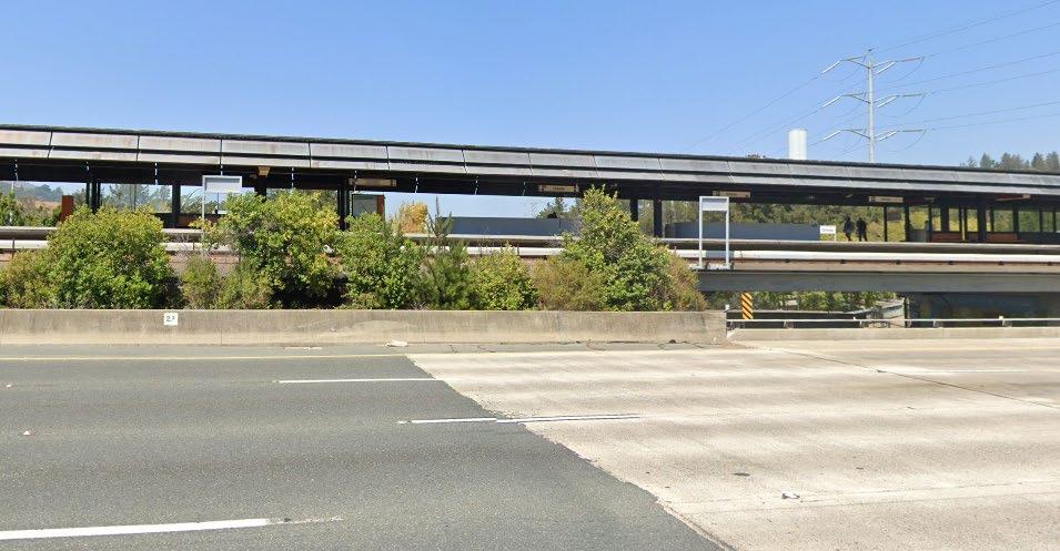
1
Pursuant to CEQA Statute Section 21099(a)(7), a transit priority area is an area within one half mile of an existing major transit stop. BART stations are considered to be major transit stops.
Similar to the proposed project, most of the DPP sites and both BART sites are located within a transit priority area. As such, aesthetic impacts related to development of the DPP Housing Element Sites within a transit priority area would remain less than significant in compliance with CEQA Statute 21099(d). CEQA Statute 21099(d) states that “aesthetic impacts of a residential project on an infill site within a transit priority area 1 shall not be considered significant impacts on the environment.” The BART sites are located adjacent to the BART Station, within a transit priority area, and would consist of residential development on an infill site, and thus would not have significant aesthetic impacts under this statute.
Figure 6-5 View of BART Orinda Station from SR-24 West

As noted in table 4.1 1, Non Transit Priority Area DPP Housing Element Sites, are similar to the proposed project There are 12 DPP Housing Element Sites that are outside of a transit priority area. However, these sites are located in areas that have existing development and mature trees that limit expansive views. Thus, development facilitated at these DPP Housing Element Sites would not have substantially adverse effects on the views of hillsides and other scenic vistas. Housing Element Site HE 4 is not visible from SR 24. However, Housing Element Site HE 5 directly abuts SR 24, and while it is not entirely visible, motorists may still be able to see part of the development at this site. Because Alternative 2 does not include this site, it would lessen aesthetic and visual impacts when compared to the proposed project.
Alternatives Draft Environmental Impact Report 6 21
Would the project: ProposedProject
Temporary construction related air quality impacts that would result from grading and construction would be increased compared to the proposed project, as building envelopes and overall sizes would increase. Similar to the proposed project, Alternative 2 would encourage denser housing within proximity to services, bus stops, bike routes, and the Orinda BART station. Similar to the proposed project, Alternative 2 would reduce related operational air quality impacts through reducing VMT and imposing requirements for Minimum Efficiency Reporting Value 13 (or equivalent) filters for heating/cooling systems and ventilation systems in residences, which would be consistent with the primary goals of the 2017 Clean Air Plan. The project would remain consistent with the following 2017 Clean Air Plan Policies:
AQ 2: Result in a cumulatively considerable net increase of any criteria pollutant for which the project region is nonattainment under an applicable federal or state ambient air quality standard? LTSM LTSM
GHG 1: Generate GHG emissions, either directly or indirectly, that may have a significant impact on the environment? LTS LTS
TR9. Bicycle and Pedestrian Access and Facilities. Encourage planning for bicycle and pedestrian facilities in local plans, e.g., general and specific plans, fund bike lanes, routes, paths and bicycle parking facilities.
City of Orinda Plan Orinda 6-22
GHG 2: Conflict with an applicable plan, policy or regulation adopted for the purpose of reducing the emissions of GHGs? LTS LTS
AQ 3: Expose sensitive receptors to substantial pollutant concentrations? LTSM LTSM
AQ 4: Result in other emissions (such as those leading to odors) adversely affecting a substantial number of people? LTS LTS
AQ 1: Conflict with or obstruct implementation of the applicable air quality plan? LTS LTS
Alternative 2: DPP Plus SitesBART
Summary: Under Alternative 2 impacts to air quality and GHG emissions would be less than significant and would be slightly reduced per service population, but would be increased overall when compared to the proposed project. Alternative 2 is similar to the proposed project in that it would be consistent with all applicable policies and plans. Impacts would be less than significant.
EN2. Decrease Electricity Demand. Work with local governments to adopt additional energy efficiency policies and programs. Support local government energy efficiency program via best practices, model ordinances, and technical support. Work with partners to develop messaging to decrease electricity demand during peak times.
Air Quality and Greenhouse Gas Emissions
BL1. Green Buildings. Collaborate with partners such as KyotoUSA to identify energy-related improvements and opportunities for on site renewable energy systems in school districts; investigate funding strategies to implement upgrades. Identify barriers to effective local implementation of the California Green Building Standards Code (CALGreen, Title 24) statewide building energy code; develop solutions to improve implementation/enforcement. Work with ABAG’s BayREN program to make additional funding available for energy related projects in the buildings sector. Engage with additional partners to target reducing emissions from specific types of buildings.
Scenario (2020 Population)
Percentage change 26%
Similar to the proposed project, development under Alternative 2 would need to be compliant with all CARB and BAAQMD regulations such as recommendations for project siting and BAAQMD Regulation 11, Rule 2 to reduce impacts induced by asbestos, construction, operation, and project siting. Mitigation Measures AQ 3 would still be implemented to ensure that the project would not exceed BAAQMD thresholds. Odor impacts related to construction of development under Alternative 2 would be less than significant and similar when compared to the proposed project.
Similar to the proposed project, Alternative 2 would be generally consistent with the applicable measures as development facilitated by the project would be required to comply with the latest Title 24 regulations and would increase density in urban areas, allowing for greater use of alternative modes of transportation.
Baseline
Similar to the proposed project, the net percentage increase in VMT would be below the net percentage increase in population. Net percentage increase in VMT for Alternative 2 would be comparable to that of the proposed project. This alternative would still be required to implement Mitigation Measures AQ 1, AQ 2, and AQ 3 to reduce impacts to air quality.
Percentage change 44% (City wide) 282,986 357,344 74,358
WA4. Recycling and Waste Reduction. Develop or identify and promote model ordinances on community wide zero waste goals and recycling of construction and demolition materials in commercial and public construction projects.
Alternatives Draft Environmental Impact Report 6-23
Table 6-4 shows the estimated operational GHG emissions associated with the development facilitated by Alternative 2. As shown therein, annual emissions from full buildout of Alternative 2 envisioned an increase of 2,941 dwelling units over existing conditions which would result in 17,266 MT of CO2e per year. With a population increase of 8,233 over existing conditions, this would result in an increase of 2.1 MT of CO2e per service population. Similar to the proposed project, this would
VMT
Development of Alternative 2 would involve activities such as demolition, grading, construction worker travel, delivery and hauling of supplies and debris, and fuel combustion by on-site construction equipment that would result in air pollutant emissions. Similar to the proposed project, these activities would result in the creation of dust, fumes, equipment exhaust, and other air contaminants. Construction of the alternative would temporarily increase air pollutant emissions slightly more than the proposed project due to the increase in project size and increased construction duration. According to the BAAQMD 2017 CEQA Air Quality Guidelines, the threshold for criteria air pollutants and precursors requires an assessment of the rate of increase of plan VMT and population. Table 6-3 summarizes the net increase in population versus VMT for this alternative.
Table 6-3 Increase in Population Compared to VMT Under Alternative 2
Source: Fehr & Peers 2022 (Appendix TRA)
WR2. Support Water Conservation. Develop a list of best practices that reduce water consumption and increase on site water recycling in new and existing buildings; incorporate into local planning guidance.
Project 2040 Buildout Net Increase Population 18,839 27,072 8,233
EN8. Expand clean vehicle initiatives. Expand investments in clean vehicles, including more fuel efficient vehicles and electric vehicle subsidies and chargers.
Under Alternative 2, impacts to air quality would be less than significant with mitigation and would be similar when compared with the proposed project.
Alternative 2 Population Increase 8,233
City of Orinda Plan Orinda
Waste 681
6-24
Area 179
BAAQMD Interpolated Plan level 2031 Target 3.7 Exceed BAAQMD Targets? No
Operational Total 17,266
Additionally, Alternative 2 would be consistent with the following Plan Bay Area 2050 policies:
Policy 4.1.1L. Encourage the conservation of energy through the production of solar design, and recycling of newspaper, aluminum and bottles. Provisions should be made to allow for a conveniently located and screened recycling area in the downtown.
MT of CO2e per Service Population 2.1
EN4. Maintain urban growth boundaries. Using urban growth boundaries and other existing environmental protections, focus new development within the existing urban footprint or areas otherwise suitable for growth, as establish by local jurisdictions.
Water 238
not exceed the BAAQMD’s interpolated 2031 target of 3.7 MT CO2e per service population at the plan level. Alternative 2 would slightly reduce GHG emissions per capita (2.1 MT vs. 2.2 MT) but would increase overall emissions in comparison to the proposed project (17,266 MT vs. 14,787 MT).
Energy 3,533
Source: Appendix GHG
Operational
Table 6-4 Operational GHG Emissions for Alternative 2
Emission Source
Mobile 12,634
Policy 2.3.2N. Support bus transit, vanpools and carpool service to reduce peak hour traffic volumes.
Annual Emissions (MT of CO2e)
In addition, development under Alternative 2 would have increased compatibility with the 2017 Scoping Plan, Plan Bay Area 2050, General Plan and detailed in Section 4.2, Air Quality and Greenhouse Gas Emissions. Alternative 2 would be consistent with the 2017 Clean Air Plan control measures as development facilitated by Plan Orinda would comply with the latest Title 24 regulations and would increase density in urban areas in proximity to transit, allowing for greater use of alternative modes of transportation. Alternative 2 would be consistent with the City of Orinda General Plan Land Use and Circulation Element and Environmental Resources Element. Such policies from the General Plan would include:
BIO 3: Have a substantial adverse effect on state or federally protected wetlands as defined by Section 404 of the Clean Water Act (marsh, vernal pool, coastal, etc.) through direct removal, filling, hydrological interruption, or other means? LTSM LTSM
BIO 4: Interfere substantially with the movement of any native resident or migratory fish or wildlife species or with established native resident or migratory wildlife corridors or impede the use of native wildlife nursery sites? LTSM LTSM
BIO 2: Have a substantial adverse effect on any riparian habitat or other sensitive natural community identified in local or regional plans, policies, regulations or by the California Department of Fish and Game or U.S. Fish and Wildlife Service? LTSM LTSM
Biological Resources
Alternatives Draft Environmental Impact Report 6-25
Would the project: ProposedProject
BIO 5: Conflict with any local policies or ordinances protecting biological resources, such as a tree preservation policy or ordinance? LTS LTS
BIO 6: Conflict with the provisions of an adopted Habitat Conservation Plan, Natural Community Conservation Plan, or other approved local, regional, or State habitat conservation plan?
BIO 1: Have a substantial adverse effect, either directly or through habitat modifications, on any species identified as a candidate, sensitive, or special status species in local or regional plans, policies, or regulations, or by the California Department of Fish and Game or U.S. Fish and Wildlife Service? LTSM LTSM
NI NI
Summary: Under Alternative 2, impacts to biological resources would less than significant with mitigation and would be reduced when compared with the proposed project as this alternative would have a lower development potential on certain sites. Impacts to special status species, riparian habitat or other sensitive natural communities, wetlands, and wildlife movement would be less than significant with mitigation, and impacts involving conflict with local biological resource policies or the provisions of adopted conservation plans would be less than significant. Alternative 2 would not conflict with an existing Habitat Conservation Plan, Natural Community Plan, or other approved habitat conservation plan and would have no impact, similar to the proposed project.
Alternative 2: DPP Plus SitesBART
Special-status plant and wildlife species have the potential to occur on Housing Element Site HE-4 However, given the size of site HE-4 compared to local and regional species ranges, there is low potential for impacts to special status species on a population wide level. Housing Element Site HE-4 could provide suitable habitat for nesting birds protected under the Migratory Bird Treaty Act and California Fish and Game Code; furthermore, Housing Element Site HE 4 is adjacent to undeveloped areas that could support sensitive natural communities and contains mapped intermittent streams that may function as small corridors for urban wildlife movement. Similar to the proposed project, Mitigation Measure BIO 1 would reduce impacts to wildlife movement under this alternative by requiring biological resources studies for potential development within Housing Element Site HE-4. Under Alternative 2, impacts to biological resources from development on site HE 4 would be less than significant with mitigation and would be similar to the proposed project.
Development within the DPP Plan Area would be the same under this alternative as for the proposed project. The DPP Plan Area is not expected to contain populations of special status plant species and individual State and/or federally listed plants (as it is mostly developed and isolated from natural habitats); however, the DPP Plan Area provides marginal habitat for disturbance tolerant wildlife species as well as suitable habitat for nesting birds protected under the Migratory Bird Treaty Act (MBTA) and California Fish and Game Code (CFGC). Similar to the proposed project, implementation of Mitigation Measures BIO 1 through BIO 10 would reduce impacts to special
There are no known historical resources on Housing Element Site HE 4. As discussed in Section 4.4, Cultural Resources, eight sites in the DPP Plan Area contain known historical resources, and several sites contain buildings or structures of 45 years or more of age and therefore have the potential to qualify as historical resources. Similar to the proposed project, it is possible that development facilitated by the Housing Element or DPP could propose demolition of or alter the character defining features of a historical resource, such as through the demolition of other alteration of landscaping features or changes to a historical resource’s setting. Under Alternative 2, Mitigation Measures CUL 1 and CUL 2 would reduce impacts on historic resources by requiring project-specific evaluations and the implementation of further requirements to avoid or reduce impacts on those resources on a project by project basis.
LTSM LTSM
Cultural Resources
CR-1: Cause a substantial adverse change in the significance of a historical resource pursuant to Section 15064.5?
Both the BART A and BART B sites are currently developed with parking lots and do not contain critical habitat for special status species. Given the existence of mature trees within the sites, both sites could provide suitable habitat for nesting birds protected under the MBTA and CFGC. Both BART sites do not contain or are adjacent to riparian habitat, wetlands, or other sensitive natural communities. Removal of mature trees on the BART sites during development would be required to comply with City regulations, including tree removal permits and would require implementation of Mitigation Measure BIO 8 which would reduce impacts to nesting birds during development of BART sites to less than significant levels.
Alternative 2: DPP Plus SitesBART
status species on Housing Element Site HE-4 and within the DPP Plan Area. Within the DPP Plan Area, sensitive natural communities may occur where suitable soils are present around the edges of developed areas adjacent to open space. Similar to the proposed project, Mitigation Measures BIO 11 and BIO 12 would reduce impacts to sensitive natural communities and critical habitat by requiring biological resources studies for projects within Housing Element Site HE-4 or undeveloped areas of the DPP
Development facilitated by the project within the DPP Plan Area would potentially impact San Pablo Creek or intermittent streams that would be potentially subject to United States Army Corps of Engineers, California Department of Fish and Wildlife, and Regional Water Quality Control Board permitting requirements. Similar to the proposed project, Mitigation Measures BIO 13 and BIO 14 would reduce impacts to State and federally protected waters and wetlands by requiring jurisdictional delineations, as appropriate, for development facilitated by the project within Housing Element Site HE-4 or the DPP Plan Area, and implementation of further requirements to avoid or reduce impacts on a project by project basis.
Summary: Under Alternative 2, impacts to cultural resources would be less than significant with mitigation for historical and archaeological resources, and would be less than significant for human remains. Impacts under Alternative 2 would be similar when compared with the proposed project.
Would the project:
City of Orinda Plan Orinda
ProposedProject
LTSM LTSM
CR-2: Cause a substantial adverse change in the significance of an archaeological resource pursuant to Section 15064.5?
CR-3: Disturb any human remains, including those interred outside of formal cemeteries?
6-26
LTS LTS
Both the BART A and BART B sites are developed with existing parking lots, devoid of structures. There are no known historic resources located on either site. Given the existing development and pavement on site, it is unlikely that archaeological or cultural resources would be unearthed during development of the BART sites. However, development under this alternative would have the potential to alter the character defining features of an unknown historical resource; or damage or destroy previously unknown historic or prehistoric archaeological resources; Mitigation Measures
iv. Landslides?
Would the project:
Similar to the proposed project, ground disturbing activities associated with development facilitated by the Housing Element or DPP, under this alternative, have the potential to damage or destroy previously unknown historic or prehistoric archaeological resources. Under this alternative, Mitigation Measures CUL 3 and CUL 4 would reduce impacts on archaeological resources by requiring archaeological resource studies for projects and the implementation of further requirements to avoid or reduce impacts on those resources on a project by project basis. Similar to the proposed project, development under this alternative would be required to adhere to existing regulations regarding the treatment of human remains
CUL 1, CUL 2, CUL 3, and CUL 4 would reduce associated impacts. BART site development facilitated by this alternative would also be required to adhere to existing regulations regarding the treatment of human remains, if discovered during construction.
Alternative 2: DPP Plus SitesBART
i. Rupture of a known earthquake fault, as delineated on the most recent Alquist Priolo Earthquake Fault Zoning Map issued by the State Geologist for the area or based on other substantial evidence of a known fault
ii. Strong seismic ground shaking?
GEO 2: Result in substantial soil erosion or the loss of topsoil?
GEO 4: Be located on expansive soil, as defined in Table 18-1-B of the Uniform Building Code (1994), creating substantial direct or indirectly risks to life or property?
LTS LTS
LTS LTS
GEO 3: Be located on a geologic unit or soil that is unstable, or that would become unstable as a result of the project, and potentially result in on or off site landslide, lateral spreading, subsidence, liquefaction or collapse?
GEO 6: Directly or indirectly destroy a unique paleontological resource or site or unique geologic feature?
Summary: Impacts from Alternative 2 regarding seismicity, liquefaction, erosion or loss of topsoil, potential structural damage, paleontological resources, and wastewater systems would be similar or decreased when compared to the proposed project. The geological impacts under Alternative 2 would be less than significant, similar to the proposed project.
ProposedProject
LTS LTS
GEO 5: Have soils incapable of adequately supporting the use of septic tanks or alternative wastewater disposal systems where sewers are not available for the disposal of wastewater?
GEO 1: Directly or indirectly cause potential substantial adverse effects, including the risk of loss, injury, or death involving?
LTS LTS
iii. Seismic related ground failure, including liquefaction?
LTS LTS
LTS LTS
Geology and Soils
Alternatives Draft Environmental Impact Report 6-27
Require geologic trenching studies within all designated Earthquake Fault Studies Zones unless adequate evidence is presented, as determined and accepted by an approved Geotechnical Engineer or Engineering Geologist. The City of Orinda may require geologic trenching of nonzoned faults for especially critical, vulnerable, or lifeline structures
Policy S 21. Require new development in areas prone to geologic hazards (e.g., landslides, steep topography, slope instability), including the Orinda Geologic Hazard Abatement District, to be designed to adequately reduce these hazards, including minimizing the loss of native vegetation. Grading plans; environmental assessments; engineering and geologic technical reports; and
Alternative 2 would result in an increase in total dwelling units compared to the proposed project. Alternative 2 would be subject to NPDES General Permit for Storm Water Discharges Associated with Construction and Land Disturbance Activities (Order No. 2012 0006 DWQ) adopted by the State Water Resources Control Board (SWRCB). Compliance with these policies would reduce topsoil disturbance and erosion. Impacts to soil erosion or loss of topsoil would be similar in comparison to the proposed project. Similar to the proposed project, none of the Housing Element Sites or DPP Sites are located within or near an Alquist Priolo Earthquake Fault Zone, but the Quaternary Moraga Fault crosses Housing Element Site HE 4. However, the Moraga Fault is considered inactive, and the exact location of the fault is not known with high confidence (USGS n.d., USGS 2022). Similar to the proposed project, impacts induced by seismic shaking would be less than significant.
Policy S 18. Minimize fault rupture hazards through enforcement of the following policies:
Support efforts by the California Department of Conservation, California Geological Survey, to develop geologic and engineering solutions in areas of ground deformation due to faulting and seismic activity but where a fault cannot be reliably located.
6 28
City of Orinda Plan Orinda
Future construction on the sites under Alternative 2 would be required to comply with California Building Code requirements and implement General Plan goals and policies, ensuring the stability of new structures during seismic events or due to unstable or expansive soils. Alternative 2 would be required to comply with the following policies from the City of Orinda General Plan Safety Element Update:
Encourage and support efforts by the geologic research community to better define the locations and risks of faults in and around the City of Orinda. Such efforts could include data sharing and database development with regional entities, other local governments, private organizations, utility agencies or companies, and local universities.
Require geologic studies or analyses for critical, lifeline, and high occupancy structures and high risk structures within 0.5 miles of all Quaternary faults shown on the Earthquake Fault Studies Zones map.
Require infrastructure systems, such as energy, communications, and transportation infrastructure, that cross a fault be designed to resist fault rupture for the maximum plausible earthquake scenario.
Policy S 19. New development, including subdivisions, new construction, and remodels or expansions of existing structures, shall minimize exposure to seismic hazards through site planning and building design.
Policy S-20. A geotechnical investigation and report shall be required for all new development in landslide and liquefaction zones. Any other facility that could create a geologic hazard, such as a road on hillside terrain, must also conduct such an investigation. Evidence of probable geologic hazard shall require a geotechnical study by a registered soil engineer or registered geologist that shall be reviewed by geotechnical consultants selected by the City.
Policy S-22. Require new development in hillside areas to prepare drainage plans to direct runoff and drainage away from potential unstable slopes.
Alternative 2: DPP Plus SitesBART
HAZ-4: For a project located within an airport land use plan or, where such a plan has not been adopted, within two miles of a public airport or public use airport, result in a safety hazard or excessive noise for people residing or working in the project area?
Would the project:
Compliance with all applicable policies would result in a less than significant impact related to seismic hazards for Alternative 2 and would be similar to impacts under the proposed project
in Section 13, Utilities and Service Systems, development facilitated under Alternative 2 would occur in urban areas where wastewater infrastructure exists. However, the proposed project includes one Housing Element Site, HE 5, that would require the construction and installation new wastewater facilities. Alternative 2 excludes this Housing Element Site. Thus, impacts to wastewater and septic systems would be slightly decreased in comparison to the proposed project as no extensions to the existing infrastructure service area is needed for the development of Alternative 2.
Alternatives Draft Environmental Impact Report 6-29
HAZ-2: Emit hazardous emissions or handle hazardous or acutely hazardous materials, substances, or waste within one quarter mile of an existing or proposed school?
LTS LTS
HAZ-5: Impair implementation of or physically interfere with an adopted emergency response plan or emergency evacuation plan?
LTS LTS
HAZ-3: Be located on a site which is included on a list of hazardous materials sites compiled pursuant to Government Code Section 65962.5 and, as a result, would create a significant hazard to the public or the environment?
LTS LTS
LTS LTS
HAZ_1: Create a significant hazard to the public or the environment through the routine transport, use, or disposal of hazardous materials? Create a significant hazard to the public or the environment through reasonably foreseeable upset and accident conditions involving the release of hazardous materials into the environment?
irrigation and landscaping plans, including ecological restoration and revegetation plans, shall be required as appropriate to ensure the adequate demonstration of a project’s ability to mitigate these potential impacts.
Development facilitated under Alternative 2 would not be subject to liquefaction as there are no liquefaction zones in Orinda. Development would be subject to all current seismic standards and would comply with CBC engineering design and construction measures to reduce impacts induced by potential structural damage. Development allowed under Alternative 2, similar to development facilitated by the proposed project, would occur within areas of potentially high paleontological sensitivity. Impacts to paleontological resources would be similar in comparison to the proposed
Hazards and Hazardous Materials
ProposedProject
NI NI
Asproject.discussed
Policy S 38. Require public disclosure of all companies, facilities, buildings, and properties that use, store, produce, and/or import/export any hazardous materials and wastes in the city. The City will maintain and share its inventory with the Contra Costa County Environmental Health Department.
City of Orinda Plan Orinda 6-30
Goal S-5: A community with effective, citywide management and disposal of hazardous materials and hazardous materials wastes.
Policy S 41. Maintain the organizational framework for implementation of the California Standardized Emergency Management System (SEMS) and the National Incident Management System
Hazards and Hazardous Materials
Would the project: ProposedProject
HAZ-6: Expose people or structures to a significant risk of loss, injury or death involving wildland fires?
Alternative 2: DPP Plus SitesBART
Policy S 37. Reduce the level of risk from toxic and hazardous materials in Orinda by regulating the transportation and storage of these materials in the community, and through an educational program on the proper disposal methods for hazardous, toxic, and polluting materials.
Under Alternative 2, the transport, storage, and use of hazardous materials associated with construction of development of Housing Element Site HE-4, DPP, and BART sites, and operation of residential, commercial, and industrial uses, such as utilization of paints and solvents, would be required to comply with existing hazardous material regulations, similar to the proposed project. Sites containing existing or potential contamination would continue to require remediation and compliance with State and local regulations to allow for development. Compliance with policies within the City of Orinda updated Safety Element, including the following, would reduce risks associated with hazardous materials:
Policy S-39. Ensure that the use and disposal of hazardous materials in the city complies with local, state, and federal safety standards.
Furthermore,(NIMS).compliance with the City of Orinda 2018 Local Hazard Mitigation Plan, the Orinda Code of Ordinances, and applicable emergency response plans would ensure that development facilitated under this alternative would not increase risk of exposure to hazardous materials, would not emit hazardous emissions or waste within 0.25 mile of an existing or proposed school, and would not impair or interfere with implementation of evacuation or emergency response plans.
SU SU
Policy S 40. Encourage use of on site green infrastructure to protect and enhance community water quality and use of landscape design (e.g., berms, grasslands, plantings) to either contain released hazardous materials or to process and/or absorb pollutants to prevent them from infiltrating the soil or watershed.
Summary: Under Alternative 2, impacts involving hazards and hazardous materials would be similar when compared with the proposed project. Impacts involving significant hazards to the public or environment through the transport, use, disposal, or accidental release of hazardous materials; emission of hazardous substances within 0.25 mile of a school; contamination from hazardous material sites; and impairment of an emergency response plan would be less than significant. There would be no impact related to airports and safety hazards. Impacts related to wildland fires would be significant and unavoidable, similar to the proposed Project.
ProposedProject
Alternative 2: DPP Plus SitesBART
There are no DTSC listed cleanup sites in or around the DPP Plan Area, Site HE-4, and the BART sites, as well as no Superfund or other State Responsibility sites (Department of Toxic Substances Control [DTSC] 2022; SWRCB 2022). The City of Orinda is located more than 10 miles from the nearest airport, and no private use airports are within 2 miles of the city. Development facilitated by this alternative would not result in a safety hazard for people residing or working in the area because there are no airports near or within the city
Summary: Under Alternative 2, impacts regarding land use and planning would be less than significant and would be reduced when compared with the proposed project as it places development closer to public transit. Alternative 2 also encourages high density development in focused areas, and would not divide an established community. Impacts would remain less than significant.
Similar to the proposed project, DPP development under this alternative would encourage a mix of uses including employment opportunities, housing, recreational and cultural uses; maintain the village “small town” character of downtown while encouraging development that is compatible with existing uses, the pedestrian environment, and streetscape; and develop the area with complimentary uses consistent with the current scale and size of surrounding development. Implementation of the DPP would not result in the construction of barriers that would divide an existing community. Furthermore, development of Housing Element site HE 4 and the DPP Plan Area under Alternative 2 would be generally consistent with General Plan goals, policies, and standards, and would be consistent with Plan Bay Area 2050 or the 2017 Clean Air Plan, similar to the proposed project.
Land Use and Planning
Would the project:
Alternatives Draft Environmental Impact Report 6-31
LU-2: Cause a significant environmental impact due to a conflict with any land use plan, policy, or regulation adopted for the purpose of avoiding or mitigating an environmental effect? LTS LTS
LU-1: Physically divide an established community?
Development under this alternative would facilitate future population growth and greater densities on Housing Element Site HE 4 and within the DPP Plan Area, both of which are located adjacent to mapped VHFHSZs. Both BART sites also contain small portions located within a VHFHSZ which extends along Camino Pablo (CalFIRE 2007). Draft General Plan Safety Element Policies S 29 and S 32 would reduce associated wildland fire impacts by requiring project-specific fire prevention plans and Fire Department review prior to issuance of development permits for projects in VHFHSZs. Additionally, implementation of mitigation measures WFR 1 and WFR 2 would reduce the risk of loss of structures, injury, or death due to wildfires.
Development facilitated under Alternative 2 would not divide a community; rather, it would encourage the development of underdeveloped or underutilized properties in areas that are well served by existing infrastructure and community services Development of Housing Element Sites under this alternative would be less intensive than the proposed project, as this alternative would only include potential development of Housing Element Site HE 4.
Both the BART A and BART B sites are developed with existing parking lots. Proposed development on these sites under this alternative would not physically divide an established community, as the sites do not contain any structures and development would not include the construction of barriers,
LTS LTS
2.1.4.A. Enhance architectural compatibility in each sector of downtown by establishing design districts that provide guidelines and a review process for site layouts, architectural design, alterations, landscaping, and signs. Sloping roofs are encouraged on new buildings in districts where such features are common.
2.1.4 Downtown: Implementing Policies
2.1.3 Downtown: Guiding Policies
Alternative 2 would not result in inconsistencies with applicable land use plans adopted for the purpose of avoiding or mitigating an environmental effect.
such as new roads or other linear development or infrastructure, that would divide the surrounding community. Development of the BART parking lot sites into housing would be generally consistent with Plan Bay Area 2050, which encourages construction of adequate, affordable housing and a greater mix of housing densities; and with Orinda General Plan goals and policies, which encourage development on underutilized sites, removal of highly visible parking lots, and situating new development adjacent to major transit corridors.
Compliance with policies within the City of Orinda Land Use and Circulation Elements, including the following, would reduce risks associated with land use and planning:
City of Orinda Plan Orinda
2.1.4.B. Require planting and maintenance of trees and other plant material throughout downtown, according to a comprehensive landscape plan.
2.1.3.A. Enhance the “village character” of downtown. Large, highly visible parking lots characteristic of strip mall shopping centers are inconsistent with village character.
2.1.4.H. Regulate on street parking to maintain space availability for shoppers and continue to study means of adding to the parking supply.
2.3.1 Circulation: Guiding Policies
2.3.1.E. Expand pedestrian and bicycle paths to provide a safe alternative to auto use, particularly to provide safe paths near schools and in other locations where they are heavily used for circulation.
6 32
2.3.1.A. Permit new development only when adequate transportation systems and parking are provided.
Would the project: ProposedProject
Alternativeairports.2
Summary: Under Alternative 2, impacts involving noise would be decreased, when compared with the proposed project, as this alternative entails an increased number of total units on fewer sites than the proposed project. Impacts involving compliance with noise standards or established ordinances would remain significant and unavoidable. Impacts due to vibration would remain less than significant with mitigation and there would be no impact involving excessive noise from
would provide approximately 558 more dwelling units than the proposed project. The primary categories of noise impacts from development facilitated by Alternative 2 would be construction noise, on site operational noise associated with the regular function of new residential units and mixed use development, and off-site. There are no sensitive receptors in close proximity to the BART sites. Unlike the proposed project, it can be expected that off site noise associated with traffic would be decreased due to decreased VMT. Additionally, BART Sites are located in areas that already contain high levels of noise. Development of Alternative 2 would not further exacerbate that
Noiseissue.from individual construction projects facilitated by the DPP would temporarily increase ambient noise levels at adjacent property lines. Since the DPP does not include specific development projects, it is not possible to determine exact noise levels or time periods for construction of such projects, or construction noise at adjacent properties. Sensitive noise receivers near DPP Sites would be exposed to the highest levels of construction noise for the longest duration. There are existing uses that include sensitive receivers, such as schools, churches, parks, and residences, interspersed with or adjacent to DPP sites, specifically along the eastern borders of the DPP area. Infill development in the DPP area would include construction of high density residential and mixed use development. Due to the proximity of the DPP sites to sensitive receivers, noise impacts of construction activities resulting from development facilitated by the DPP would be similar to those resulting from the Housing Element Update and would remain significant and unavoidable. Similar to the proposed project, implementation of Mitigation Measures NOI 1 and NOI 2 would reduce construction noise and vibration to the extent feasible. As discussed in the Hazards and Hazardous Materials analysis above, the City of Orinda is located more than 10 miles from the nearest airport, and no private use airports are within 2 miles of the city; therefore, Alternative 2 would not result in impacts from excessive airport noise.
Alternative 2: DPP Plus SitesBART
SU SU
NOI 2: Generate excessive groundborne vibration or groundborne noise levels? LTSM LTSM
NOI 3: For a project located within the vicinity of a private airstrip or an airport land use plan or, where such a plan has not been adopted, within two miles of a public airport or public use airport, expose people residing or working in the project area to excessive noise levels?
Alternatives Draft Environmental Impact Report 6-33
NI NI
NOI 1: Generate a substantial temporary or permanent increase in ambient noise levels in the vicinity of the project in excess of standards established in the local general plan or noise ordinance, or applicable standards of other agencies?
Noise
ProposedProject
Population and Housing
Summary: Under Alternative 2, impacts to population and housing would be similar to the proposed project. While this alternative entails more overall development and a higher population increase than the proposed project, this growth is planned. Impacts would be less than significant.
Element Site HE-4, all DPP sites, the BART A site, and the BART B site do not contain existing people or housing that would be displaced under this alternative. If displacement would occur, new residential units would be constructed to replace existing displaced residences, in accordance with Government Code Section 65583.2(g)(3). Impacts involving displacement of people or housing under this alternative would be less than significant, similar to the proposed project.
Would the project:
LTS LTS
Alternative 2: DPP Plus SitesBART
Development facilitated under this alternative would result in approximately 2,941 new dwelling units and 8,233 new residents. Compared to the proposed project, this alternative would result in approximately 558 additional dwelling units and 1,561 additional residents. Similar to the proposed project, such population growth would exceed Plan Bay Area 2040 population and housing forecasts, but would be consistent with the City of Orinda’s RHNA allocation as assigned by ABAG Considering the Association of Bay Area Governments’ next Regional Transportation Plan/Sustainable Communities Strategy would incorporate the City’s Housing Element Update, the growth under this alternative would be anticipated. Impacts regarding substantial unplanned population growth under this alternative would be less than significant, similar to the proposed Housingproject.
POP 2: Displace substantial numbers of existing people or housing, necessitating the construction of replacement housing elsewhere?
City of Orinda Plan Orinda 6-34
POP 1: Induce substantial unplanned population growth in an area, either directly (for example, by proposing new homes and businesses) or indirectly (for example, through extension of roads or other infrastructure)?
LTS LTS
Alternatives Draft Environmental Impact Report 6-35
PS 4: Result in substantial adverse physical impacts associated with the need for or provision of new or physically altered government facilities, the construction of which could cause significant environmental impacts, in order to maintain acceptable service ratios, response times, or other objectives for?
PS-3: Result in substantial adverse physical impacts associated with the need for or provision of new or physically altered government facilities, the construction of which could cause significant environmental impacts, in order to maintain acceptable service ratios, response times, or other objectives for?
LTS LTS
PS 5: Result in substantial adverse physical impacts associated with the need for or provision of new or physically altered government facilities, the construction of which could cause significant environmental impacts, in order to maintain acceptable service ratios, response times, or other objectives for?
ProposedProject
Summary: Under Alternative 2, impacts involving public services and recreation would be similar, when compared with the proposed project. This alternative would result in less than significant impacts regarding substantial adverse physical impacts associated with the provision of new or physically altered public facilities and parks, substantial physical deterioration of existing recreational facilities, and construction or expansion of recreational or library facilities that might have an adverse physical effect on the environment.
Development facilitated by Alternative 2 would increase calls for fire services throughout the City, primarily near downtown and BART stations, with the exception of Housing Element Site HE-4. The MOFD currently responds to 3,000 incidents annually for approximately 38,500 residents (including
v. Other public facilities?
Development facilitated by Alternative 2 would increase the demand for fire protection, police protection, schools, parks, recreational facilities, and other public facilities when compared to existing conditions. This alternative would introduce approximately 1,561 more residents than the proposed project, which would result in increased demands for schools, parks, recreational facilities, libraries, and other public services. Additionally, development facilitated by the DPP would increase service calls within Orinda’s downtown area for fire, police, or emergency medical services. However, new facilities would not be needed to serve the project.
Public Services and Recreation
Would the project:
PS 1: Result in substantial adverse physical impacts associated with the need for or provision of new or physically altered government facilities, the construction of which could cause significant environmental impacts, in order to maintain acceptable service ratios, response times, or other objectives for?
Alternative 2: DPP Plus SitesBART
ii. Police protection?
PS 2: Result in substantial adverse physical impacts associated with the need for or provision of new or physically altered government facilities, the construction of which could cause significant environmental impacts, in order to maintain acceptable service ratios, response times, or other objectives for?
iii. Schools? LTS LTS
i. Fire protection LTS LTS
LTS LTS
LTS LTS
iv. IncreaseParks?theuse of existing neighborhood and regional parks or other recreational facilities such that substantial physical deterioration of the facility would occur or be accelerated? Include recreational facilities or require the construction or expansion of recreational facilities which might have an adverse physical effect on the environment?
Development under this alternative would introduce new residents to the city; the addition of 8,233 new residents would decrease Orinda’s parkland ratio to six acres per 1,000 residents. However, this ratio would remain above the City’s threshold of five acres per 1,000 residents. Quimby Act park in lieu fees and park impact fees pursuant to Orinda Municipal Code Chapter 3.28 would generate funds necessary for creation of new parks commensurate with new development. Additionally, the following General Plan policies would ensure maintenance of existing parkland and open space:
2.2.1.D Retain creeks and wildlife access corridors as open space for preservation of natural resources, consistent with flood control.
2.2.1.E. Retain existing private and public recreational open space, and acquire additional land for public park development to meet the needs of all sectors of Orinda and all age groups in the community. A minimum of five acres of land for each 1,000 city residents should be devoted to public park and recreational purposes but more may be needed.
6 36
2.2.1.H. The Orinda Community Center is an important recreational, educational, and public facility for this community and before any major expansion or change in use is permitted as such facility, full public hearings for land use permits shall be held with the understanding that recreation and education are the primary uses.
population of the Town of Moraga), which is about 0.08 incidents per resident. Therefore, development facilitated by Alternative 2 would induce approximately 657 annual incidents. Site HE 4, all DPP sites, and the BART sites are within MOFD’s existing service area and within 2 miles of the nearest fire station. Thus, emergencies on these sites would generally be responded to within current response times and would not require additional fire stations to be built. Additionally, compliance with General Plan policies that encourage fire protection and prevention education, as well as payment of fire protection development impact fees, would minimize impacts associated with increased demand for fire protection services. Similar to the proposed project, impacts to fire protection services would be less than significant.
2.2.1.A. Support preservation of East Bay Municipal Utility District (EBMUD) watershed lands.
City of Orinda Plan Orinda
Development facilitated under this alternative on Housing Element Site HE 4, DPP sites, and BART sites would be required to pay school impact fees. Pursuant to Section 65995 (3)(h) of the California Government Code, the payment of statutory fees “is deemed to be full and complete mitigation of the impacts of any legislative or adjudicative act, or both, involving, but not limited to, the planning, use, or development of real property, or any change in governmental organization or reorganization.” Thus, if fees are paid for the provision or expansion of new school facilities, it would offset impacts from development under this alternative. Therefore, existing laws and regulations would require funding for the provision or expansion of new school facilities to offset impacts from Alternative 2, as is the case with the proposed project. Similar to the proposed project, impacts to school facilities would be less than significant.
Based on Orinda Police Department’s (OPD) current staffing level of 13 sworn officers, under this alternative, the OPD’s officer/resident ratio would drop from 0.66 to 0.48 officers per 1,000 residents. General Plan Policy 5.4.2.C encourages the provision of capital facilities sufficient to maintain an average two beat minimum patrol configuration. OPD currently maintains two beats, patrolled by at least one officer per beat. Additionally, the BART A and BART B sites would be served by the BART Police Department, which would provide support for OPD should they be unable to fully serve the area at an average two beat minimum. Similar to the proposed project, impacts to police services would be less than significant.
Similar to the proposed project, Alternative 2 would be unable to meet screening criteria for exemption from VMT analysis, as described in Section 4.11, Transportation. While residential development facilitated by Alternative 2 would be expected to be consistent with Plan Bay Area 2050, and would not result in a net reduction in multi family units on the individual development sites, the first two criteria (CEQA Exemption and Small Projects) cannot be ascertained until development projects are proposed. In addition, because the transit priority area only extends to a portion of the DPP area, Housing Element sites, and BART planning areas, the City has elected to undertake a VMT analysis for the project as a whole. It should be noted however, that individual projects that are proposed within the transit priority area following adoption of the Housing
Alternative 2: DPP Plus SitesBART
Development projects facilitated under Alternative 2 would be subject to all applicable General Plan policies, City guidelines, standards, and specifications related to transit, bicycle, or pedestrian facilities. Therefore, Alternative 2 would result in a less than significant impact to transit, bicycle, and pedestrian facilities similar to the proposed project.
under this alternative would add approximately 8,233 new residents to the city which would result in increased visits to the Orinda Library. Although there are currently no specific plans for a library expansion, any needed future expansion would likely occur to the existing facility, which is in an urbanized area of Orinda, and would be developed as infill development Library services are funded by the Special Library Services Parcel Tax, described in Chapter 3.32 of the Orinda Municipal Code. The annual tax is determined by multiplying a baseline $69.00 by an equivalency factor, described in detail in the Municipal Code. Provision of additional services are determined by the City and funded using this tax. Payment amount for development of the proposed project would be determined on a project by project basis. The City would conduct an evaluation of the expansion’s environmental impacts as appropriate. Similar to the proposed project, impacts to public facilities, such as libraries, would be less than significant.
LTSM LTS
ProposedProject
Similar to the proposed project, impacts to parks and recreational facilities would be less than significant.Development
TRA 4: Result in inadequate emergency access to development sites? LTSM LTSM
LTS LTS
TRA 1: Conflict with an applicable program, plan, ordinance, or policy establishing measures of effectiveness for the performance of addressing the circulation system including transit, bicycle, and pedestrian facilities?
Transportation
TRA 3: Result in designs for on site circulation, access, and parking areas that fail to meet City or industry standard design guidelines?
SU SU
Would the project:
Summary: Under Alternative 2 impacts to transportation would be reduced to that of the proposed project. Impacts to VMT per service population would also be similar to the proposed project on the countywide level and would be slightly reduced on the citywide level under both 2020 and 2040 conditions. Impacts to transportation design and operational VMT would be significant, but would be reduced with mitigation.
Alternatives Draft Environmental Impact Report 6-37
TRA 2: Conflict or be inconsistent with CEQA Guidelines section 15064.3, subdivision (b). For the purposes of this evaluation, this impact would be significant if the implementation of Plan Orinda would generate home based VMT per resident within the planning areas that would be higher than 85 percent of the countywide average home based VMT per resident?
Citywide Average 282,986 378,261 16.3 15.1 85% of 2020 Countywide Average 14.7 14.7
Project Area 56,759 121,542 14.6 13.3
Source: Contra Costa Countywide Travel Demand Model; Fehr & Peers, May 2022.
VMT Area Home-Based
Home-Based
6-38
City of Orinda Plan Orinda
Table 6-5 VMT Summary: 2020 With Alternative 2 VMT/Resident
AverageCountywide 19,965,854 22,315,636 17.3 16.0
Project Area 56,759 130,705 14.6 13.3
The analysis indicates the following:
Citywide Average 282,986 357,344 16.3 14.5 85% of AverageCountywide2020 14.7 14.7
Source: Contra Costa Countywide Travel Demand Model; Fehr & Peers, May 2022.
Countywide Average 19,965,854 20,085,282 17.3 17.3
Project <85% of Countywide Average? Yes
The City of Orinda VMT per resident of 15.1 miles-per-resident for Alternative 2 is below the countywide average VMT per resident of 17.3 miles per resident in the 2020 baseline.
The VMT rates within Alternative 2 are projected to be less than 85 percent of the baseline countywide average for Alternative 2, in both 2020 and 2040.
Table 6-6 VMT Summary: 2040 With Alternative 2
Project <85% of Average?Countywide Yes
2020 Home-Based 2020 Home Based + Alternative 2 2020 Based/ResidentHome 2020 Alternative+2/Resident
Element may be screened out, requiring no VMT analysis, and would in that case be assumed to have no significant impact on VMT.
Home-Based
VMT Area VMT VMT/Resident Base 2040 +
2020
Alternative 2 2020 Base 2040 + Alternative 2
As part of this DEIR analysis, the Contra Costa Countywide Travel Demand Model was adjusted to reflect the relevant housing unit numbers for Alternative 2 for 2020 and 2040 conditions (see Table 6-5 and Table 6-6 below) Under Alternative 2, citywide average VMT would be slightly reduced compared to existing conditions and compared to the proposed project for both 2020 and 2040 conditions.
VMT rates in the County as a whole, and in the City of Orinda, are projected to decline between 2020 and 2040.
The BART A and BART B sites would be developed in conformance with BART’s Transit Oriented Design Guidelines (2017) which provides guidance on creating pedestrian friendly areas with good connectivity and a greater mix of transit supportive land uses, as well as a requirement that a comprehensive transportation demand management program be implemented to minimize the number of motor vehicle trips being generated by the alternative. Based on these considerations, implementation of Mitigation Measure TRA 2 would continue to be required to reduce impacts related to transportation design to a less than significant level.
Alternative 2: DPP Plus SitesBART
LTSM LTSM
Construction of Alternative 2 may involve large trucks for hauling and transportation of heavy equipment and may require full or partial lane closures for construction staging on some sites. For this reason, Mitigation Measure TRA 3 would be required. Similar to the proposed project, Alternative 2 would not be associated with specific development projects and thus, specific projects developed under the alternative cannot be analyzed for adequacy of emergency transportation access at this time. Emergency access to new development sites proposed under Alternative 2 would be subject to review by the City of Orinda, Caltrans, and responsible emergency service agencies, thus ensuring the projects would be designed to meet all emergency access and design standards. Under this alternative, the City would draft guidelines that require the preparation of construction management plans that minimize temporary obstruction of traffic during site construction. Additionally, Mitigation Measure TRA 2 would be required to reduce impacts related to transportation design to a less than significant level. Due to the expected increase in population induced by Alternative 2, additional vehicles associated with development of sites could increase delays for emergency response vehicles during peak commute hours. However, it is assumed that due to the proximity of the DPP Sites and BART Sites to public transit, there would be fewer vehicles on the road during peak hours. Thus, Alternative 2 would not inhibit emergency responders access to roads in the case of an emergency. Impacts would be less than significant.
TCR 2: Would the project cause a substantial adverse change in the significance of a tribal cultural resource as defined in Public Resources Code Section 21074 that is a resource determined by the lead agency, in its discretion and supported by substantial evidence, to be significant pursuant to criteria set forth in subdivision (c) of Public Resources Code Section 5024.1?
ProposedProject
Proximity of the BART sites to BART stations would allow easier access to public transportation, and lower VMT levels induced by Alternative 2. However, countywide averages would remain the same per resident at 2020 levels and only slightly reduced per resident at 2040 levels. Similar to the proposed project, Mitigation Measure TRA 1 would be required. However, impacts would remain significant and unavoidable.
LTSM LTSM
Alternatives Draft Environmental Impact Report 6-39
Tribal Cultural Resources
TCR 1: Would the project cause a substantial adverse change in the significance of a tribal cultural resource as defined in Public Resources Code Section 21074 that is listed or eligible for listing in the California Register of Historical Resources, or in a local register of historical resources as defined in Public Resources Code Section 5020.1(k)?
Summary: Impacts to tribal cultural resources under Alternative 2 would be less than significant with mitigation, similar to the proposed project.
Would the project:
LTSM LTS
UTIL 1: Require or result in the relocation or construction of new or expanded water, wastewater treatment or stormwater drainage, electric power, natural gas, or telecommunications facilities, the construction or relocation of which could cause significant environmental effects?
6-40
Would the project:
ProposedProject
Utilities and Service Systems
Summary: Under Alternative 2, impacts to utilities and service systems would be less than significant although they would be greater, when compared with the proposed project, as this alternative entails more overall development than the proposed project. However, impacts would be less than significant.
LTS LTS
City of Orinda Plan Orinda
Alternative 2: DPP Plus SitesBART
As discussed in Section 4.13, Utilities and Service Systems, development facilitated by the DPP would not result in construction or relocation of water or wastewater facilities such that significant environmental impacts would result. Additional storm drains and system connections necessary to
LTS LTS
UTIL-3: Generate solid waste in excess of State or local standards, or in excess of the capacity of local infrastructure, or otherwise impair the attainment of solid waste reduction goals? Comply with federal, state, and local management and reduction statutes and regulations related to solid waste?
Development of Housing Element Site HE-4 under Alternative 2 may require the installation of additional water main lines, lateral connections, and hydrants within the city, as well as the installation of upsized sewer lines and additional lateral connections. Such facilities would be installed during individual project construction and within the disturbance area of such projects or the rights of way of previously disturbed roadways. Therefore, the construction of these infrastructure improvements would not substantially increase the Housing Element Update’s disturbance area, substantially impact transportation circulation through increased construction timelines, or otherwise cause significant environmental effects. Regarding stormwater drainage, development on the partially-undeveloped Housing Element Site HE 4 would convert existing permeable surfaces into impervious surfaces. Conversion of these surfaces would allow for increased stormwater runoff and needed drainage. However, compliance with existing regulations, including the State Construction Stormwater Permit, the Clean Water Act, and Title 18, Chapter 18.02 (Stormwater Management and Discharge Control) would reduce impacts associated with stormwater drainage. Regarding other utility connections, based on the availability of existing electrical and telecommunications infrastructure at site HE 4, this site would be able to connect to existing infrastructure without requiring expanded or new facilities
UTIL 2: Have sufficient water supplies available to serve the project and reasonably foreseeable future development during normal, dry, and multiple dry years? Result in a determination by the wastewater treatment provider which serves or may serve the project that it has adequate capacity to serve the projects’ projected demand in addition to the provider’s existing commitments?
To date, tribal consultation between the City and consulting tribes has not resulted in the identification of any known tribal cultural resources within the City of Orinda. However, there is potential for development facilitated by this alternative to impact subsurface tribal cultural resources. Implementation of Mitigation Measures TCR-1, TCR 2, and TCR 3 would help reduce impacts to unknown subsurface resources. Implementation of these mitigation measures would reduce potential impacts by requiring avoidance, treatment plans, and monitoring in areas identified as sensitive for tribal cultural resources.
The Central Contra Costa Sanitary District (CCCSD) provides wastewater treatment services to the City of Orinda. This alternative would facilitate development that would increase the 2031 population of Orinda by 41 percent over the ABAG 2031 projected population. Accordingly, wastewater generation would be expected to increase by approximately 16.2 million gallons per day
serve development would generally be installed within the already disturbed rights of way of existing roads or within the disturbance footprints of DPP projects. Completion of capital storm drain improvement projects within the DPP Plan Area would ensure adequate stormwater system capacity to serve development facilitated by the DPP. Based on the availability of existing electrical and telecommunications infrastructure in the Plan Area, DPP sites would be able to connect to existing infrastructure.
Similar to Housing Element Site HE 4, development of the BART sites may require the installation of additional water main lines, lateral connections, and hydrants within the city, as well as the installation of upsized sewer lines and additional lateral connections. Such facilities would be installed during individual project construction and within the disturbance area of such projects or the rights of way of previously disturbed roadways. Both BART sites are currently parking lots covered with impervious surface; development on these sites would utilize existing storm drain infrastructure. Similar to the DPP sites, completion of capital storm drain improvement projects would ensure adequate stormwater system capacity to serve BART site development. Based on the availability of existing electrical and telecommunications infrastructure within the BART Station area, BART sites would be able to connect to existing infrastructure.
Alternatives Draft Environmental Impact Report 6 41
Additionally, compliance with CALGreen water reduction requirements would further reduce water usage for this alternative. Because this alternative would involve an incremental increase to EBMUD’s future service populations, and because EBMUD anticipates additional water supply not included in its planning level of demand, projected water supplies would be sufficient to serve development under this alternative.
Development under this alternative would facilitate the addition of an estimated 8,233 new residents to the city. The population increase associated with this alternative would exceed ABAG 2031 population projections by approximately 7,851 people. Given East Bay Municipal Utility District (EBMUD) uses ABAG population projections to determine its future service populations in its Urban Water Management Plan, this alternative would also exceed the UWMP estimated service population of 1,554,800 by approximately 7,851 people, or approximately 0.5 percent. Similar to the proposed project, this increase would be negligible (less than one percent increase) and would be accounted for as the UWMP does not factor in anticipated levels of additional conserved and recycled water into its planning level of water demand (EBMUD 2021). However, compliance with the standards set out in the Water Conservation Strategic Plan would be required. The goal of these standards is to create a framework for water utilities and end users throughout the State to achieve water conservation today to prepare for future drought conditions. To be eligible for water service, new developments must meet indoor and outdoor water efficiency standards for plumbing fixtures, appliances, landscaping, and commercial processes that use water (EBMUD 2021). For the indoor residential value, the target is based on population and an indoor water use standard expressed in gallons per capita per day (GPCD). The initial target is 55 GPCD in 2020. In 2025, the target is reduced to 52.5 GPCD or a different standard as recommended by the SWRCB and DWR (EBMUD 2020). In 2030, the target is further reduced to 50 GPCD or a different standard as recommended by the SWRCB and DWR (EBMUD 2020) The standard for outdoor residential consumption is based on the community’s climate and the total amount of landscaped area, demonstrating compliance with the Water Conservation Act of 2009.
Alternative 2 could facilitate the development of 2,941 dwelling units. Based on a solid waste generation rate of 5.31 pounds per dwelling unit per year (CalRecycle 2019), Alternative 2 would generate an estimated 15,601 pounds of solid waste per day. This would equate to approximately 2,847 tons per year, 19.5 cubic yards per day, or 7,118 cubic yards per year. 3 Keller Canyon Landfill has a permitted capacity of 3,500 tons per day and approximately 63.4 million cubic yards of remaining capacity. Under this alternative, the project would yield an annual solid waste generation of approximately 2,847 tons per year. This would account for less than 0.01 percent of the remaining capacity of the Keller Canyon Landfill. Therefore, development facilitated under this alternative would not generate solid waste in excess of the capacity of local solid waste
Summary: Under Alternative 2, impacts involving wildfire would be significant and unavoidable but slightly decreased than under the proposed project. Sites developed under Alternative 2, while in VHFHSZ, would be located closer to primary evacuation routes. Alternative 2 excludes Housing Element Sites HE 1 through HE-3 (on Moraga Way) and HE-5 (off Hwy 24), which are not as close to primary evacuation routes. Due to decreased VMT, emergency responders would likely have easier access to a fire at or near these sites. Alternatively, the proposed project has sites located in various locations around the City, some of which are not in close proximity to any established evacuation routes. \. Development facilitated by Alternative 2 in the DPP would not exacerbate existing environmental conditions; however, existing codes and regulations cannot fully prevent the possibility of wildfires damaging structures or occupants. Impacts would be significant and unavoidable.
under Alternative 2 would also be required to demonstrate compliance with all applicable regulations, including AB 939, which requires cities and counties to prepare integrated waste management plans and to divert 50 percent of solid waste from landfills beginning in calendar year 2000 and each year thereafter; SB 1383, which established the goals of a 50 percent reduction in the level of the statewide disposal of organic waste from 2014 levels by 2020, and a 75 percent reduction in the level of the statewide disposal of organic waste from 2014 levels by 2025; and Orinda Municipal Code Section 15.10.010, which adopts the most recent version of CALGreen and contains construction waste recycling requirements.
Wildfire
Alternative 2: DPP Plus SitesBART
WFR 2: Due to slope, prevailing winds, and other factors, exacerbate wildfire risks, and thereby expose project occupants to pollutant concentrations from a wildfire or the uncontrolled spread of a wildfire? Require the installation or maintenance of associated infrastructure (such as roads, fuel breaks, emergency water sources, power lines or other utilities) that may exacerbate fire risk or that may result in temporary or ongoing impacts to the environment? Expose people or structures to significant risks, including downslope or downstream flooding or landslides, as a result of runoff, post-fire slope instability, or drainage changes? Expose people or structures, either directly or indirectly, to a significant risk of loss, injury or death involving wildland fires?
2 The 2031 projected CCCSD wastewater generation, 39.4 mgd, multiplied by 41 percent, is approximately 16.2 mgd.
City of Orinda Plan Orinda 6-42
SU SU
Would the project:
3 Household trash is approximately 800 pounds per cubic yard (CalRecycle 2019).
SU SU
ProposedProject
WFR 1: Substantially impair an adopted emergency response plan or emergency evacuation plan?
Dinfrastructure.evelopmentfacilitated
over 2031 projected wastewater generation. 2 This increase in wastewater would be within the CCCSD treatment plant’s capacity of 70 million gallons per day. Therefore, the CCCSD would have sufficient capacity to accommodate wastewater generated by this alternative.
Alternatives Draft Environmental Impact Report 6 43
Bothwildfire.BART
For potential evacuation, Housing Element Site HE 4 would rely on Moraga Way, the DPP sites would rely on SR 24, Camino Pablo and Moraga Way, and the BART sites would rely on BART service and SR 24. Similar to the proposed project, development facilitated under this alternative would not impair the use of emergency evacuation routes through the modification of existing roadways, and would be constructed in accordance with federal, state, regional, and local requirements, which are intended to ensure the safety of city residents and structures to the extent feasible. Compliance with these standard regulations would be consistent with the County’s Emergency Operations Plan’s goals and objectives. Impacts involving substantial impairment of an adopted emergency response plan or emergency evacuation plan under this alternative would be less than significant, similar to the proposed project
Development under this alternative would facilitate future population growth and greater densities on Housing Element Site HE 4 and within the DPP Plan Area, both of which are located adjacent to mapped VHFHSZs, as well as on both BART sites, which contain small portions covered by a VHFHSZ that extends along Camino Pablo (CalFIRE 2007). Similar to the proposed project, goals and policies in the updated Safety Element would mitigate the risk of loss of life, injury, and property loss from wildfires. Policies S 26 through S 38 would maintain Fire Department fire protection standards, continue wildfire mitigation strategies such as fuel breaks in open spaces and fire access easements, require proposed development to have adequate access for fire and emergency services, and maintain evacuation routes in the event of an emergency. Additionally, implementation of Mitigation Measures WFR 1 and WFR 2 would reduce the risk of loss of structures, injury, or death due to wildfires; these measures would make structures more fire resistant and less vulnerable to loss in the event of a wildfire, as well as reduce the potential for construction activities to ignite a
DPP Sites adjacent to Camino Pablo would abut, and may overlap with, the VHFHSZ that covers the roadway. DPP Sites in closest proximity include DPP 8, 9, 11, 12, and DPP 39 through 47. New construction would also be subject to the California Fire Code, which includes safety measures to minimize the threat of fire, including ignition resistant construction with exterior walls of
Sites and Housing Element Site HE 4 would have access to emergency routes. HE 4 would generally rely on Moraga Way and BART Sites and DPP would rely on SR 24. Since all sites would have access to emergency routes, impacts related to emergency evacuation would be decreased when compared to the proposed project. However, future development under Alternative 2 may result in impacts. An impact to emergency operations and evacuations could occur from construction of future projects if they were to result in temporary road closures, potentially reducing available emergency evacuation routes. Construction of new development could involve temporary lane closures or otherwise block traffic that could impede the ability of emergency vehicles to access the area. This would be limited to the construction duration and only affect streets adjacent to the construction site. Development facilitated by the project could further inhibit safe evacuation by introducing more residents to the area that would require evacuation on narrow hillside roadways. As such, impacts related to emergency response plan or emergency evacuation plan would be significant.
As noted in Section 4.14.2, Regulatory Setting, increases in density in already developed areas, such as site HE 4, have also been shown to reduce fire risk. Similarly, both BART Sites are located in highly developed areas. However, HE 4 is located near slopes, known landslide susceptible areas, and vegetative wildfire fuels. Therefore, Mitigation Measure WFR 1 would be required to reduce the risk of wildfire during project construction for future development on site HE 4. Impacts would be reduced in comparison to the project.
Development facilitated by the project in the DPP would not exacerbate existing environmental conditions; however, existing codes and regulations cannot fully prevent the possibility of wildfires damaging structures or occupants. The project would increase the exposure of new residential development to risk of loss or damage from wildfire, which would be a significant impact. Therefore, Mitigation Measures WFR 1 and WFR 2 would be required.
noncombustible or ignition resistant material from the surface of the ground to the roof system and sealing any gaps around doors, windows, eaves and vents to prevent intrusion by flame or embers. Fire sprinklers would be required in residential developments (with some exceptions) pursuant to the Contra Costa County Code. Construction would also be required to meet CBC requirements, including CCR Title 24, Part 2, which includes specific requirements related to exterior wildfire exposure. The Board of Forestry, via CCR Title 14, sets forth the minimum development standards for emergency access, fuel modification, setback, signage, and water supply, which help prevent loss of structures or life by reducing wildfire hazards. The codes and regulations would reduce the risk of loss, injury, or death from wildfire for new residential developments encouraged by the project, but not Goalsentirely.andpolicies
6 44
in the updated Safety Element would mitigate the risk of loss of life, injury, and property loss from wildfires. Proposed Policies S 24 through S 38 would maintain MOFD fire protection standards, continue wildfire mitigation strategies such as fuel breaks in open spaces and fire access easements, require proposed development to have adequate access for fire and emergency services, and maintaining evacuation routes in the event of an emergency.
Based on the analysis herein, impacts to aesthetics, air quality, biological resources, cultural resources, geology and soils, greenhouse gas emissions, hazards and hazardous materials, land use and planning, noise, population and housing, public services and recreation, transportation, tribal cultural resources, and wildfire would be similar to or less than the proposed project. However, impacts to utilities would be greater than that of the proposed project. The proposed project was determined not to have a cumulatively considerable contribution to cumulative impacts as discussed in each of the environmental issue areas As impacts under Alternative 2 would be similar to or incrementally decreased compared to the proposed project, impacts under Alternative 2 would not be cumulatively considerable.
City of Orinda Plan Orinda
In comparison to existing conditions, Alternative 2 would result in impacts to aesthetics, air quality, biological resources, cultural resources, geology and soils, noise, transportation, tribal cultural resources, utilities, and wildfire. Alternative 2 would have considerable cumulative impacts as discussed in each of the resource areas. However, Alternative 2 would be consistent with the goals outlined in the Housing Element and DPP.
Cumulative Impacts
Alternative 3: No DPP
6.3.1 Description
6.3
The analysis of Alternative 3 includes some components present in the proposed project. Those similar components are the inclusion of Housing Element Sites HE 1 through HE 5. Due to this overlap, the analysis done for these sites in regard to the proposed project also applies to Alternative 3. The impact analysis in Alternative 3 focuses on impacts that are different from the project’s, due to the removal of the DPP Sites and the addition of the BART Sites
Alternative 3 analyzes all of the identified Housing Element Sites (HE 1 through HE 5) along with two parking lots adjacent to the Orinda BART station (BART A and BART B). Although the number of dwelling units would increase under this alternative compared to the proposed project, Alternative 3 would exclude all of the DPP sites identified for future housing, and thus would involve development on fewer sites throughout the City. See Table 6 7 for details. Figure 6 6 displays the location of Alternative 3.
This alternative would result in approximately 1,854 new dwelling units and approximately 5,190 new residents. This would equate to approximately 529 fewer units and approximately 1,482 fewer residents than the proposed project. This alternative would be consistent with most of the project objectives; development facilitated under this alternative would meet the State required RHNA for 6th Cycle Housing Element planning period of 2023 2031, identify housing sites with a collective capacity to meet the City’s RHNA, with buffer capacity, and locate most housing sites in existing urban areas, near transit and commercial services.
Alternatives Draft Environmental Impact Report 6 45
HE-1 Holy Shepherd Lutheran Church 433 Moraga Way 3.22 33% Church/Parking 0 25 27 75
BART-A Caltrans BART - Eastern Lot 5.78 75% Parking lot 0 75 325 910
City Orinda
Site # Location
Plan Orinda 6-46
1 Only a portion of the parcel could be developed with housing. This percentage represents the maximum portion of the site that could provide housing as estimated by the City and housing consultant.
HE-3 St. John Orthodox Church 501 Moraga Way 4.94 33% Church/Parking 0 25 41 114
HE-5 Caltrans – Gateway No address, off California Shakespeare Theater Way 10.19 100% Vacant 0 40 408 1141
du/ac = dwelling unit per acre ft = feet
Total 1,854 5,190
of
Table 6-7 Alternative 3 Details
Acreage PercentageBuildableof Site1 CurrentUse Existing Units Proposed du/ac AllowableMaximumUnits AdditionalMaximumResidents
HE-4 Miramonte High School 750 Moraga Way 51.95 18% School 0 25 234 655
BART-B Caltrans BART - Western Lot 20.36 50% Parking lot 0 75 764 2,138
HE-2 St. Mark's Church 451 Moraga Way 4.48 50% Church/Parking 0 25 56 157
Alternatives Draft Environmental Impact Report 6 47
Figure 6-6 Location of Alternative 3

City of Orinda Plan Orinda 6.3.26-48
of all Housing Element Sites would result in less than significant impacts with mitigation for scenic vistas, state scenic resources, visual character, and lighting or glare. Although Housing Element sites HE 1 through HE-4 are located along Moraga Way, which is a designated scenic corridor within the City of Orinda, development on these sites would be required to comply with the future Objective Design Standards, which would regulate siting and neighborhood context, design, privacy, view, light, air, and landscaping. Compliance with existing regulations, such as the City of Orinda Zoning Ordinance, the City of Orinda General Plan Land Use and Circulation Element, and the City of Orinda Hillside & Ridgeline Design Guidelines, would reduce potential impacts to aesthetics or visual resources under this alternative and would make impacts to aesthetics less than significant when compared to the proposed project. Of the sites, Housing Element Site HE 5 is the only site that may be slightly visible to motorists from SR 24. Mitigation Measure AES 1 would require that all development comply with future Objective Design Standards that will define the requirements for
Impact Analysis
Alternative 3: No DPP
Except as provided in Public Resources Code Section 21099, would the project: ProposedProject
LTSM LTSM
As discussed in the Aesthetics analysis for Alternative 2, and in accordance with CEQA Statute 21099(d), development on the BART sites would result in less than significant impacts with mitigation for scenic vistas, state scenic resources, visual character, and lighting or glare.
AES 4: Create a new source of substantial light or glare that would adversely affect daytime or nighttime views in the area?
AES 1: Have a substantial adverse effect on a scenic vista? LTS LTS
LTSM LTSM
AES 2: Substantially damage scenic resources, including but not limited to, trees, rock outcroppings, and historic buildings within a state scenic highway? LTSM LTSM
Summary: Impacts under Alternative 3 would be less than significant and reduced compared with the proposed project for visual character and lighting or glare, as this alternative entails less overall development than the proposed project. Development under this alternative would occur at Housing Element Sites HE 1 through HE 5 and both BART Sites, but exclude DPP Sites. When considering impacts to scenic vistas, Alternative 3 would result in less than significant impacts, similar to the proposed project. Due to inclusion of the BART sites adjacent to SR 24, Alternative 3 would result in partially obstructed views within a state scenic highway. This impact would be greater than obstruction of views of nearby scenic resources by the proposed project. However, pursuant to CEQA Statute 21099(d), the impacts of this alternative would be less than significant.
Inclstories.usion
Aesthetics
Views along SR 24 are already partially obstructed due to the siting of current BART stations. Views from the westbound lanes are already partially obstructed to the south due to existing BART stations. These views could be further obstructed by additional development. However, views to the north would not be impacted. Views from the eastbound lanes to the south would not have obstructed views, while views to the north from the eastbound lanes are also already partially obstructed. New development around BART stations may increase this impact and further obstruct views. BART Transit Oriented Design standards limit all development at the BART Sites to five
AES 3: In non urbanized areas, substantially degrade the existing visual character or quality of public views of the site and its surroundings? (Public views are those that are experienced from a publicly accessible vantage point). If the project is in an urbanized area, would the project conflict with applicable zoning and other regulations governing scenic quality?
Temporarysignificant.
EN2. Decrease Electricity Demand. Work with local governments to adopt additional energy efficiency policies and programs. Support local government energy efficiency program via best practices, model ordinances, and technical support. Work with partners to develop messaging to decrease electricity demand during peak times.
GHG 1: Generate GHG emissions, either directly or indirectly, that may have a significant impact on the environment?
AQ 3: Expose sensitive receptors to substantial pollutant concentrations? LTSM LTSM
LTS LTS
TR9. Bicycle and Pedestrian Access and Facilities. Encourage planning for bicycle and pedestrian facilities in local plans, e.g., general and specific plans, fund bike lanes, routes, paths and bicycle parking facilities.
Would the project: ProposedProject
LTS LTS
construction related air quality impacts that result from grading and construction would be less than significant and would be slightly less when compared to the proposed project, due to smaller building footprints and a decrease in the overall amount of development sites Alternative 3 would not include the DPP sites, thus decreasing the number of additional dwelling units introduced to the city and reducing the population, which could result in decreased air quality emissions. Similar to the proposed project, Alternative 3 would encourage denser housing with proximity to services, bus stops, bike routes, and the Orinda BART station through development adjacent to BART However, development of Housing Element Sites HE 1 through HE 5 would not encourage denser housing with proximity to services, bus stops, bike routes, or the Orinda BART station. Alternative 3 would increase related air quality impacts from existing conditions through increasing VMT. The project would remain consistent with the following 2017 Clean Air Plan Policies:
Air Quality and Greenhouse Gas Emissions
Alternative 3: No DPP
Alternatives Draft Environmental Impact Report 6-49
AQ 1: Conflict with or obstruct implementation of the applicable air quality plan? LTS LTS
AQ 2: Result in a cumulatively considerable net increase of any criteria pollutant for which the project region is nonattainment under an applicable federal or state ambient air quality standard? LTSM LTSM
trees and vegetation to soften views along Moraga Way. Similar to the proposed project, impacts to scenic highways would be less than significant with mitigation.
BL1. Green Buildings. Collaborate with partners such as KyotoUSA to identify energy-related improvements and opportunities for on site renewable energy systems in school districts; investigate funding strategies to implement upgrades. Identify barriers to effective local implementation of the CALGreen (Title 24) statewide building energy code; develop solutions to improve implementation/enforcement. Work with ABAG’s BayREN program to make additional
AQ 4: Result in other emissions (such as those leading to odors) adversely affecting a substantial number of people?
GHG 2: Conflict with an applicable plan, policy or regulation adopted for the purpose of reducing the emissions of GHGs?
Summary: Under Alternative 3 impacts to air quality and GHG emissions would be slightly reduced per service population and reduced overall when compared to the proposed project. Alternative 3 has similar impacts compared to the proposed project because it would be consistent with applicable policies and plans. Impacts would be less than
LTS LTS
WR2. Support Water Conservation. Develop a list of best practices that reduce water consumption and increase on site water recycling in new and existing buildings; incorporate into local planning guidance.
Development of Alternative 3 would involve activities such as demolition, grading, construction worker travel, delivery and hauling of supplies and debris, and fuel combustion by on-site construction equipment that result in air pollutant emissions. Similar to the proposed project, these activities would result in the creation of dust, fumes, equipment exhaust, and other air contaminants. Construction of this alternative would temporarily increase air pollutant emissions slightly more than the proposed project due to the increase in project size and increased construction duration. According to the BAAQMD 2017 CEQA Air Quality Guidelines, the threshold for criteria air pollutants and precursors requires an assessment of the rate of increase of plan VMT and population. Table 6-8 summarizes the net increase in population versus VMT for the alternative.
Scenario Baseline (2020 Population) Project 2040 Buildout Net Increase Population 18,839 24,029 5,190 Percentage change 24% VMT (City wide) 282,986 312,386 29,400 Percentage change 10%
Similar to the proposed project, the net percentage increase in VMT is below the net percentage increase in population. Net percentage increase in VMT for Alternative 3 would be slightly lower to that of the proposed project. The alternative would be required to implement Mitigation Measures AQ 1, AQ 2, and AQ 3 to reduce impacts to air quality.
City of Orinda Plan Orinda 6-50
Similar to the proposed project, Alternative 3 would be required to comply with all CARB and BAAQMD regulations such as recommendations for project siting and BAAQMD Regulation 11, Rule 2 to reduce impacts induced by asbestos, construction, operation, and project siting. Mitigation Measures AQ 3 would be implemented to ensure that the project would not exceed BAAQMD thresholds. Odor impacts related to construction of development facilitated by Alternative 3 would be similar when compared to the proposed project.
Source: Fehr & Peers 2022 (Appendix TRA)
WA4. Recycling and Waste Reduction. Develop or identify and promote model ordinances on community wide zero waste goals and recycling of construction and demolition materials in commercial and public construction projects.
Similar to the proposed project, Alternative 3 would be generally consistent with the applicable measures as development facilitated by the project would be required to comply with the latest Title 24 regulations, including the residential indoor air quality requirements in the Title 24 Building Energy Efficiency Standards, which currently require Minimum Efficiency Reporting Value 13 (or equivalent) filters for heating/cooling systems and ventilation systems in residences (Section 150.0[m]).) The project would also increase density in urban areas, allowing for greater use of alternative modes of transportation.
Table 6-8 Increase in Population Compared to VMT Under Alternative 3
funding available for energy related projects in the buildings sector. Engage with additional partners to target reducing emissions from specific types of buildings.
MT of CO2e per Service Population 2.0
Area 166 Energy 1,980 Mobile 7,395 Waste 429 Water 160
Under Alternative 3, impacts to air quality would be slightly decreased when compared to the proposed project due to increased VMT when compared with the proposed project. With implementation of mitigation measures, impacts would be less than significant.
Annual Emissions (MT of CO2e)
Operational Total 10,131
Alternative 3 Population Increase 5,190
Operational
Table 6-9 Operational GHG Emissions for Alternative 3 Emission Source
Alternatives Draft Environmental Impact Report 6-51
Table 6-9 shows the operational GHG emissions associated with the development facilitated by Alternative 3
BAAQMD Interpolated Plan level 2031 Target 3.7 Exceed BAAQMD Targets? No
Source: Appendix GHG
under Alternative 3 would have the same compatibility with the 2017 Scoping Plan, Plan Bay Area 2050, City General Plan and detailed in Section 4.2, Air Quality and Greenhouse Gas Emissions Alternative 3 would be consistent with the 2017 Clean Air Plan control measures as development facilitated by Plan Orinda would comply with the latest Title 24 regulations and would increase density in urban areas in proximity to transit, allowing for greater use of alternative modes of transportation Alternative 3 would be consistent with the City of Orinda General Plan Land Use and Circulation Element and Environmental Resources Element. Such policies from the General Plan would include:
As shown therein, annual emissions from full buildout of Alternative 3 envisioned an increase of 1,854 dwelling units over existing conditions. The number of units under this alternative would be 529 dwelling units fewer than that of the proposed project. Alternative 3 would produce 10,131 MT of CO2e per year. With a population increase of 5,190 over existing conditions, this alternative would result in an increase of 2.0 MT of CO2e per service population. Similar to the proposed project, this would not exceed the BAAQMD’s interpolated 2031 target of 3.7 MT CO2e per service population at the plan level. Alternative 3 would slightly reduce GHG emissions per capita (2.0 MT vs. 2.2_MT) and reduce overall emissions in comparison to the proposed project (10,131 MT vs In14,787_MT).addition,development
Policy 4.1.1L. Encourage the conservation of energy through the production of solar design, and recycling of newspaper, aluminum and bottles. Provisions should be made to allow for a conveniently located and screened recycling area in the downtown.
Policy 2.3.2N. Support bus transit, vanpools and carpool service to reduce peak hour traffic volumes.
BIO 4: Interfere substantially with the movement of any native resident or migratory fish or wildlife species or with established native resident or migratory wildlife corridors or impede the use of native wildlife nursery sites? LTSM LTSM
Summary: Under Alternative 3, overall impacts to biological resources would be less than significant with mitigation, and lesser when compared with the proposed project, as this alternative would exclude DPP Sites, thus reducing impacts to biological resources. Impacts to special status species, riparian habitat or other sensitive natural communities, wetlands, and wildlife movement would be less than significant with mitigation, and impacts involving conflicts with local biological resource policies or the provisions of adopted conservation plans would be less than
in the Biological Resources analysis for Alternative 2, development on the BART sites would result in less than significant impacts regarding riparian habitat or other sensitive natural communities, wetlands, wildlife movement, conflict with local biological resource policies, and conflict with the provisions of adopted conservation plans. Development on the BART sites would result in impacts to special status species, which would be mitigated to a less than significant level through implementation of Mitigation Measure BIO 8.
City of Orinda Plan Orinda 6-52
Special-status plant and wildlife species have the potential to occur on Housing Element Sites HE-3, HE-4, and HE 5, and all Housing Element Sites could potentially provide suitable habitat for nesting birds protected under the MBTA and CFGC. Implementation of Mitigation Measures BIO 1 through BIO 10 would reduce associated impacts to special status species. Riparian habitat or other sensitive natural communities have the potential to occur in the Housing Element Sites and surrounding areas; additionally, Housing Element Site HE-5 overlaps with critical habitat for the Alameda whipsnake. Implementation of Mitigation Measures BIO 11 and BIO 12 would reduce impacts to sensitive natural communities and critical habitat. Under this alternative, development would impact intermittent streams on Housing Element Sites HE-3, HE 4, and HE 5; however, Mitigation
BIO 3: Have a substantial adverse effect on state or federally protected wetlands as defined by Section 404 of the Clean Water Act (marsh, vernal pool, coastal, etc.) through direct removal, filling, hydrological interruption, or other means? LTSM LTSM
BIO 1: Have a substantial adverse effect, either directly or through habitat modifications, on any species identified as a candidate, sensitive, or special status species in local or regional plans, policies, or regulations, or by the California Department of Fish and Game or U.S. Fish and Wildlife Service? LTSM LTSM
EN4. Maintain urban growth boundaries. Using urban growth boundaries and other existing environmental protections, focus new development within the existing urban footprint or areas otherwise suitable for growth, as establish by local jurisdictions.
Alternative 3: No DPP
Biological Resources
Assignificant.discussed
Would the project: ProposedProject
BIO 6: Conflict with the provisions of an adopted Habitat Conservation Plan, Natural Community Conservation Plan, or other approved local, regional, or State habitat conservation plan? NI NI
BIO 2: Have a substantial adverse effect on any riparian habitat or other sensitive natural community identified in local or regional plans, policies, regulations or by the California Department of Fish and Game or U.S. Fish and Wildlife Service? LTSM LTSM
BIO 5: Conflict with any local policies or ordinances protecting biological resources, such as a tree preservation policy or ordinance? LTS LTS
Additionally, Alternative 3 would be consistent with the following Plan Bay Area 2050 policies:
As discussed in the Cultural Resources analysis for Alternative 2, similar to the proposed project, development on the BART sites would result in significant but mitigable impacts involving historic or archaeological resources, and would result in less than significant impacts for human remains.
Alternatives Draft Environmental Impact Report 6-53
Similar to the proposed project, impacts involving conflict with local biological resource policies and conflict with the provisions of adopted conservation plans would be less than significant under this alternative. Development facilitated by this alternative would comply with existing regulations, including tree removal permits. Additionally, there are no Habitat Conservation Plans or Natural Community Conservation Plans that have been adopted for the Housing Element Sites and thus, no impact would occur.
CR-3: Disturb any human remains, including those interred outside of formal cemeteries?
Alternative 3: No DPP
Summary: Under Alternative 3, impacts to cultural resources would be less than significant and reduced when compared with the proposed project, as this alternative entails less overall development than the proposed project. Such impacts would remain less than significant after mitigation measures have been implemented for historic and archaeological resources, and would be less than significant for human remains.
Would the project: ProposedProject
LTS LTS
CR-1: Cause a substantial adverse change in the significance of a historical resource pursuant to Section 15064.5?
CR-2: Cause a substantial adverse change in the significance of an archaeological resource pursuant to Section 15064.5?
Cultural Resources
Measures BIO 13 and BIO 14 would reduce impacts to wetlands by requiring jurisdictional delineations for Housing Element Sites. Intermittent streams on Housing Element Sites HE 4 and HE-5 may function as small corridors for urban wildlife movement, but implementation of Mitigation Measure BIO 1 would reduce impacts to wildlife movement by requiring biological resources studies for projects within Housing Element Sites HE 3, HE 4, and HE 5. Similar to the proposed project, development on the Housing Element sites would result in significant but mitigable impacts to special status species, riparian habitat or other sensitive natural communities, wetlands, and wildlife movement.
LTSM LTSM
LTSM LTSM
Although no historic resources were identified on Housing Element Update sites, development under this alternative would occur on parcels containing buildings that meet the age threshold for potential historical resources. Implementation of Mitigation Measures CUL 1 and CUL 2 would be necessary to reduce impacts on historic resources by requiring historic resource evaluations for projects and the implementation of further requirements to avoid or reduce impacts on those resources on a project by project basis. Additionally, development on Housing Element Update sites may unearth previously undiscovered archaeological resources, but implementation of Mitigation Measures CUL 3 and CUL 4 would reduce impacts to archaeological resources by requiring archaeological resource studies for projects and the implementation of further requirements to avoid or reduce impacts on those resources on a project by project basis. Similar to the proposed project, excavation on Housing Element sites during construction activities would have the potential to disturb human remains; however, development facilitated by this alternative would be required to adhere to existing regulations regarding the treatment of human remains, resulting in less than significant impacts.
LTS LTS
GEO 3: Be located on a geologic unit or soil that is unstable, or that would become unstable as a result of the project, and potentially result in on or off site landslide, lateral spreading, subsidence, liquefaction or collapse?
Summary: Alternative 3’s impacts concerning seismicity, liquefaction, erosion or loss of topsoil, potential structural damage, and wastewater systems would be less than significant. Impacts to paleontological resources would be less than significant. The geological impacts under Alternative 3 would be less than significant, similar to the proposed
Rupture of a known earthquake fault, as delineated on the most recent Alquist Priolo Earthquake Fault Zoning Map issued by the State Geologist for the area or based on other substantial evidence of a known fault
GEO 2: Result in substantial soil erosion or the loss of topsoil?
City of Orinda Plan Orinda 6-54
GEO 1: Directly or indirectly cause potential substantial adverse effects, including the risk of loss, injury, or death involving?
LTS LTS
Alternative 3: No DPP
iii. Seismic related ground failure, including liquefaction?
LTS LTS
Require geologic studies or analyses for critical, lifeline, and high occupancy structures and high risk structures within 0.5 miles of all Quaternary faults shown on the Earthquake Fault Studies Zones map.
iv. Landslides?
ProposedProject
LTS LTS
3 would be subject to NPDES General Permit for Storm Water Discharges Associated with Construction and Land Disturbance Activities (Order No. 2012 0006 DWQ) adopted by the SWRCB. Compliance with these policies would reduce topsoil disturbance and erosion. Similar to the proposed project, impacts related to erosion would be less than significant. No Housing Element Sites are located within or near an Alquist Priolo Earthquake Fault Zone, but the Quaternary Moraga Fault crosses Housing Element Site HE-4, similar to the proposed project. However, the Moraga Fault is considered inactive, and the exact location of the fault is not known with high confidence (USGS n.d., USGS 2022). Similar to the proposed project, impacts induced by seismic shaking would be less than significant.
Would the project:
LTS LTS
Alternativeproject.
Geology and Soils
LTS LTS
GEO 6: Directly or indirectly destroy a unique paleontological resource or site or unique geologic feature?
GEO 4: Be located on expansive soil, as defined in Table 18-1-B of the Uniform Building Code (1994), creating substantial direct or indirectly risks to life or property?
Future construction on any of the sites under Alternative 3 would be required to comply with California Building Code requirements and implement General Plan goals and policies, ensuring the stability of new structures during seismic events or due to unstable or expansive soils. Alternative 3 would be required to be compliant with the following proposed policies from the City of Orinda General Plan Safety Element Update: Policy S 18. Minimize fault rupture hazards through enforcement of the following policies:
GEO 5: Have soils incapable of adequately supporting the use of septic tanks or alternative wastewater disposal systems where sewers are not available for the disposal of wastewater?
ii. Strong seismic ground shaking?
Policy S 21. Require new development in areas prone to geologic hazards (e.g., landslides, steep topography, slope instability), including the Orinda Geologic Hazard Abatement District, to be designed to adequately reduce these hazards, including minimizing the loss of native vegetation. Grading plans; environmental assessments; engineering and geologic technical reports; and irrigation and landscaping plans, including ecological restoration and revegetation plans, shall be required as appropriate to ensure the adequate demonstration of a project’s ability to mitigate these potential impacts.
Policy S-20. A geotechnical investigation and report shall be required for all new development in landslide and liquefaction zones. Any other facility that could create a geologic hazard, such as a road on hillside terrain, must also conduct such an investigation. Evidence of probable geologic hazard shall require a geotechnical study by a registered soil engineer or registered geologist that shall be reviewed by geotechnical consultants selected by the City.
Similar to the proposed project, compliance with all applicable policies would result in a less than significant impact for Alternative 3
Similar to the proposed project, development facilitated under Alternative 3 would not be subject to liquefaction as there are no liquefaction zones in Orinda. Development would be subject to all current seismic standards and would comply with CBC engineering design and construction measures to reduce impacts induced by potential structural damage. Development allowed under Alternative 3, similar to development facilitated by the proposed project, would occur within areas of potentially high paleontological sensitivity. Impacts to paleontological resources would be slightly decreased in comparison to the proposed project and would be less than significant
Policy S 19. New development, including subdivisions, new construction, and remodels or expansions of existing structures, shall minimize exposure to seismic hazards through site planning and building design.
Require geologic trenching studies within all designated Earthquake Fault Studies Zones unless adequate evidence is presented, as determined and accepted by an approved Geotechnical Engineer or Engineering Geologist. The City of Orinda may require geologic trenching of nonzoned faults for especially critical, vulnerable, or lifeline structures
Require infrastructure systems, such as energy, communications, and transportation infrastructure, that cross a fault be designed to resist fault rupture for the maximum plausible earthquake scenario.
Policy S-22. Require new development in hillside areas to prepare drainage plans to direct runoff and drainage away from potential unstable slopes.
As discussed in Section 13, Utilities and Service Systems, development facilitated under Alternative 3 would occur in urban areas where wastewater infrastructure exists. However, Alternative 3 includes Housing Element Site HE 5 which would require the construction and installation of new wastewater
Support efforts by the California Department of Conservation, California Geological Survey, to develop geologic and engineering solutions in areas of ground deformation due to faulting and seismic activity but where a fault cannot be reliably located.
Encourage and support efforts by the geologic research community to better define the locations and risks of faults in and around the City of Orinda. Such efforts could include data sharing and database development with regional entities, other local governments, private organizations, utility agencies or companies, and local universities.
Alternatives Draft Environmental Impact Report 6 55
6-56
HAZ-5: Impair implementation of or physically interfere with an adopted emergency response plan or emergency evacuation plan?
Under Alternative 3, the transport, storage, and use of hazardous materials associated with construction of development of Housing Element sites, and operation of residential uses, such as utilization of paints and solvents, would be required to comply with existing hazardous material regulations, similar to the proposed project. Sites containing existing or potential contamination would continue to require remediation and compliance with State and local regulations to allow for development. Compliance with policies within the City of Orinda General Plan updated Safety Element, including the following, would reduce risks associated with hazardous materials:
Hazards and Hazardous Materials
HAZ-4: For a project located within an airport land use plan or, where such a plan has not been adopted, within two miles of a public airport or public use airport, result in a safety hazard or excessive noise for people residing or working in the project area?
Would the project: ProposedProject
HAZ-3: Be located on a site which is included on a list of hazardous materials sites compiled pursuant to Government Code Section 65962.5 and, as a result, would create a significant hazard to the public or the environment?
Alternative 3: No DPP
HAZ-2: Emit hazardous emissions or handle hazardous or acutely hazardous materials, substances, or waste within one quarter mile of an existing or proposed school?
LTS LTS
Summary: As Alternative 3 would entail development of fewer sites than the proposed project, impacts involving hazardous materials would be reduced when compared to the proposed project. Under this alternative, impacts involving significant hazards to the public or environment through the transport, use, disposal, or accidental release of hazardous materials; emission of hazardous substances within 0.25 mile of a school; contamination from hazardous material sites; and impairment of an emergency response plan would be less than significant. There would be no impact related to airports and safety hazards. However, impacts involving wildland fires would be significant and unavoidable with mitigation, similar to the proposed Project
LTS LTS
LTS LTS
NI NI
SU SU
As discussed in the Hazards and Hazardous Materials analysis for Alternative 2, development on the BART sites would result in less than significant impacts regarding significant hazards to the public or environment through the transport, use, disposal, or accidental release of hazardous materials; emission of hazardous substances within 0.25 mile of a school; contamination from hazardous material sites; and impairment of an emergency response plan. Development on the BART sites would also result in no impacts involving airports and safety hazards, but would result in significant and unavoidable impacts regarding exposure to wildland fires, similar to the proposed project.
City of Orinda Plan Orinda
LTS LTS
facilities. Impacts to wastewater and septic systems would be less than significant, similar to the proposed project.
HAZ-6: Expose people or structures to a significant risk of loss, injury or death involving wildland fires?
HAZ 1: Create a significant hazard to the public or the environment through the routine transport, use, or disposal of hazardous materials? Create a significant hazard to the public or the environment through reasonably foreseeable upset and accident conditions involving the release of hazardous materials into the environment?
Policy S-39. Ensure that the use and disposal of hazardous materials in the city complies with local, state, and federal safety standards.
Alternatives Draft Environmental Impact Report 6 57
Policy S 38. Require public disclosure of all companies, facilities, buildings, and properties that use, store, produce, and/or import/export any hazardous materials and wastes in the city. The City will maintain and share its inventory with the Contra Costa County Environmental Health Department.
Furthermore,(NIMS).compliance with the City of Orinda 2018 Local Hazard Mitigation Plan, the Orinda Municipal Code, and applicable emergency response plans would ensure that development facilitated under this alternative would not increase risk of exposure to hazardous materials, would not emit hazardous emissions or waste within 0.25 mile of an existing or proposed school, and would not impair or interfere with implementation of evacuation or emergency response plans.
There are no DTSC listed cleanup sites, Superfund site, or other State Responsibility sites in or around the Housing Element sites (DTSC 2022; SWRCB 2022). The City of Orinda is located more than 10 miles from the nearest airport, and no private use airports are within 2 miles of the city. Development facilitated by this alternative would not result in a safety hazard for people residing or working in the area because there are no airports near or within the city.
Goal S 5: A community with effective, citywide management and disposal of hazardous materials and hazardous materials wastes.
Development under this alternative would facilitate future population growth and greater densities on Housing Element sites, which are located adjacent to mapped VHFHSZs Housing Element Site HE 5 is located within a VHFHSZ. Draft General Plan Safety Element Policies S 29 and S 32 would reduce associated wildland fire impacts by requiring project specific fire prevention plans and Fire Department review prior to issuance of development permits for projects in VHFHSZs. Additionally, implementation of Mitigation Measures WFR 1 and WFR 2 would reduce the risk of loss of structures, injury, or death due to wildfires to the greatest degree possible
Policy S 40. Encourage use of on site green infrastructure to protect and enhance community water quality and use of landscape design (e.g. berms, grasslands, plantings) to either contain released hazardous materials or to process and/or absorb pollutants to prevent them from infiltrating the soil or watershed.
Policy S 37. Reduce the level of risk from toxic and hazardous materials in Orinda by regulating the transportation and storage of these materials in the community, and through an educational program on the proper disposal methods for hazardous, toxic, and polluting materials.
Policy S 41. Maintain the organizational framework for implementation of the California Standardized Emergency Management System (SEMS) and the National Incident Management System
LU-2: Cause a significant environmental impact due to a conflict with any land use plan, policy, or regulation adopted for the purpose of avoiding or mitigating an environmental effect? LTS LTS
A and BART B sites are developed with existing parking lots. Proposed development on these sites under this alternative would not physically divide an established community, as the sites do not contain any structures and development would not include the construction of barriers, such as new roads or other linear development or infrastructure, that would divide the surrounding community. Development of the BART parking lot sites into housing would be generally consistent with Plan Bay Area 2050, which encourages construction of adequate, affordable housing and a greater mix of housing densities; and with Orinda General Plan goals and policies, which encourage development on underutilized sites, removal of highly visible parking lots, and situating new development adjacent to major transit corridors
BothOrdinance.theBART
LTS LTS
Compliance with policies within the City of Orinda Land Use and Circulation Elements, including the following, would reduce risks associated with land use and planning:
Would the project:
2.1.4.A. Enhance architectural compatibility in each sector of downtown by establishing design districts that provide guidelines and a review process for site layouts, architectural design, alterations, landscaping, and signs. Sloping roofs are encouraged on new buildings in districts where such features are common.
2.1.4.B. Require planting and maintenance of trees and other plant material throughout downtown, according to a comprehensive landscape plan.
The Housing Element Update would contain policies that would ensure established communities would not be divided by development on Housing Element sites. Policy 1.1 would allow diversity of housing types without compromising the semi rural character of Orinda. Policy 1.4 would ensure that the design quality is consistent with the site and its surroundings. Policy 4.1 would ensure that housing development standards in the City’s zoning regulations are consistent with the Zoning
ProposedProject
City of Orinda Plan Orinda 6-58
Alternative 3: No DPP
2.1.3
Summary: Under Alternative 3, impacts regarding land use and planning would be less than significant, similar when compared with the proposed project.
Downtown: Guiding Policies
Land Use and Planning
LU-1: Physically divide an established community?
As discussed in the Land Use and Planning analysis for Alternative 2 in Section 6.2.2 above, development on the BART sites would result in less than significant impacts regarding physical division of an established community or conflict with land use plans, policies, or regulations adopted for the purpose of avoiding or mitigating an environmental effect.
2.1.3.A. Enhance the “village character” of downtown. Large, highly visible parking lots characteristic of strip mall shopping centers are inconsistent with village character.
Downtown: Implementing Policies
2.1.4
Alternative 3: No DPP
Development on Housing Element sites under this alternative would be generally consistent with General Plan goals, policies, and standards, and would not result in inconsistencies with Plan Bay Area 2050 or the 2017 Clean Air Plan, similar to the proposed project Impacts would remain less than significant.
NOI 1: Generate a substantial temporary or permanent increase in ambient noise levels in the vicinity of the project in excess of standards established in the local general plan or noise ordinance, or applicable standards of other agencies?
NOI 3: For a project located within the vicinity of a private airstrip or an airport land use plan or, where such a plan has not been adopted, within two miles of a public airport or public use airport, expose people residing or working in the project area to excessive noise levels?
Noise
SU LTS
2.1.4.H. Regulate on street parking to maintain space availability for shoppers and continue to study means of adding to the parking supply.
Circulation: Guiding Policies
2.3.1.E. Expand pedestrian and bicycle paths to provide a safe alternative to auto use, particularly to provide safe paths near schools and in other locations where they are heavily used for circulation.
NI NI
Under Alternative 3, impacts involving noise would be less than significant and lessened, when compared with the proposed project, as this alternative entails less overall development than the proposed project. Additionally, BART Sites are located in areas that have higher noise. Marginal
Would the project: ProposedProject
Summary: Under Alternative 3, impacts involving noise would be decreased when compared with the proposed project, as this alternative entails an increased number of total units on fewer sites than the proposed project. Impacts involving noise would remain significant and unavoidable. Impacts due to vibration would be less than significant with mitigation and there would be no impact involving excessive noise from airports.
Alternatives Draft Environmental Impact Report 6-59
2.3.1
2.3.1.A. Permit new development only when adequate transportation systems and parking are provided.
NOI 2: Generate excessive groundborne vibration or groundborne noise levels? LTSM LTSM
Alternative 3 would provide approximately 1,854 new dwelling units, which would be 529 fewer dwelling units than the proposed project. Under this alternative, construction durations and long term noise impacts resulting from building operation would be less than significant and incrementally reduced compared to the proposed project, due to the decreased buildout. As this alternative would result in approximately 1,482 fewer new residents than the proposed project, noise related to vehicle travel would be decreased when compared to the proposed project. Under Alternative 3, overall VMT would be decreased in comparison to the proposed project, and thus, noise would be decreased. Similar to the proposed project, implementation of Mitigation Measures NOI 1 and NOI 2 would reduce construction noise and vibration to the extent feasible. As discussed in the Hazards and Hazardous Materials analysis above, the City of Orinda is located more than 10 miles from the nearest airport, and no private use airports are within 2 miles of the city; therefore, this alternative would not result in impacts from excessive airport noise. There would be no impact involving excessive noise from airports
impacts to VMT would not substantially add to the existing noise near these sites. There are no sensitive receivers located near the BART Sites. The Housing Element Sites are located in various areas around the City. Construction noise and noise induced by increased VMT would be dispersed. Impacts involving increased noise would not be centralized in any singular location or be located in areas where significant noise is not already present. Therefore, impacts due to noise or excessive vibration would be less than significant.
Population and Housing
POP 1: Induce substantial unplanned population growth in an area, either directly (for example, by proposing new homes and businesses) or indirectly (for example, through extension of roads or other infrastructure)? LTS LTS
Alternative 3: No DPP
ProposedProject
City of Orinda Plan Orinda
Similar to the proposed project, such population growth would exceed Plan Bay Area 2040 population and housing forecasts, but would be consistent with the City of Orinda’s RHNA. Considering the Association of Bay Area Governments’ next Regional Transportation Plan/Sustainable Communities Strategy would incorporate the City’s Housing Element Update, growth under Alternative 3 would therefore be anticipated. Impacts regarding substantial unplanned population growth under this alternative would be less than significant, similar to the proposed project.
Would the project:
POP 2: Displace substantial numbers of existing people or housing, necessitating the construction of replacement housing elsewhere? LTS LTS
Summary: Under Alternative 3, impacts involving population and housing would be less than significant and reduced when compared with the proposed project, as this alternative entails a smaller population increase than the proposed Developmentproject.
All Housing Element sites, the BART A site, and the BART B site do not currently contain existing people or housing that would be displaced under this alternative. If displacement did occur, new residential units would be constructed to more than replace existing displaced residences, in accordance with Government Code Section 65583.2(g)(3). Impacts involving displacement of people or housing under this alternative would be less than significant, similar to the proposed project.
facilitated under Alternative 3 would result in approximately 1,854 new dwelling units and 5,190 new residents. Compared to the proposed project, this alternative would result in approximately 529 fewer dwelling units and 1,482 fewer residents.
6-60
Under Alternative 3, impacts involving population and housing would be less than significant and lesser, when compared with the proposed project, as this alternative entails a smaller population increase than the proposed project
PS-5: Result in substantial adverse physical impacts associated with the need for or provision of new or physically altered government facilities, the construction of which could cause significant environmental impacts, in order to maintain acceptable service ratios, response times, or other objectives for?
i. Fire protection LTS LTS
Alternative 3: No DPP
LTS LTS
iv. IncreaseParks?theuse of existing neighborhood and regional parks or other recreational facilities such that substantial physical deterioration of the facility would occur or be accelerated? Include recreational facilities or require the construction or expansion of recreational facilities which might have an adverse physical effect on the environment?
Summary: Under Alternative 3, impacts involving public services and recreation would be similar to the proposed project. Alternative 3 would result in less than significant impacts regarding substantial adverse physical impacts associated with the provision of new or physically altered public facilities and parks, substantial physical deterioration of existing recreational facilities, and construction or expansion of recreational facilities that might have an adverse physical effect on the environment.
iii. Schools? LTS LTS
PS-4: Result in substantial adverse physical impacts associated with the need for or provision of new or physically altered government facilities, the construction of which could cause significant environmental impacts, in order to maintain acceptable service ratios, response times, or other objectives for?
ProposedProject
Alternatives Draft Environmental Impact Report 6-61
Would the project:
Public Services and Recreation
PS 1: Result in substantial adverse physical impacts associated with the need for or provision of new or physically altered government facilities, the construction of which could cause significant environmental impacts, in order to maintain acceptable service ratios, response times, or other objectives for?
ii. Police protection? LTS LTS
Development facilitated under Alternative 3 would increase the demand for fire protection, police protection, schools, parks, recreational facilities, and other public facilities when compared to existing conditions. This alternative would introduce approximately 529 fewer residents than the proposed Developmentproject.facilitated by Alternative 3 would increase calls for fire services throughout the City. The MOFD currently responds to 0.08 incidents per resident. Therefore, development facilitated by Alternative 3 would induce approximately 415 annual incidents. All Housing Element and BART sites are within MOFD’s existing service area and 2 miles of the nearest fire station. Thus, emergencies on these sites would generally be responded to within current response times and would not require additional fire stations to be built. Additionally, compliance with General Plan policies that
PS-3: Result in substantial adverse physical impacts associated with the need for or provision of new or physically altered government facilities, the construction of which could cause significant environmental impacts, in order to maintain acceptable service ratios, response times, or other objectives for?
PS-2: Result in substantial adverse physical impacts associated with the need for or provision of new or physically altered government facilities, the construction of which could cause significant environmental impacts, in order to maintain acceptable service ratios, response times, or other objectives for?
v. Other public facilities?
LTS LTS
Development facilitated by this alternative on Housing Element Sites or BART sites would be required to pay school impact fees. Pursuant to California Government Code Section 65995 (3)(h), the payment of statutory fees “is deemed to be full and complete mitigation of the impacts of any legislative or adjudicative act, or both, involving, but not limited to, the planning, use, or development of real property, or any change in governmental organization or reorganization.” Thus, existing law would require funding for the provision or expansion of new school facilities, offsetting impacts from development under this alternative. According to the Orinda Union School District, a resolution was passed on June 1, 2020 to increase developer fees. As stated in the Facilities Master Plan, school fees are $4.08 per square foot of residential construction and $0.66 per square foot of commercial construction. Fees are split between the Orinda Union School District (70 percent) and the Acalanes Union High School District (30 percent). Thus, implementation of school impact fees for future projects would serve to mitigate any required expansion or construction of school facilities. Similar to the proposed project, impacts to school facilities would be less than significant.
Based on Orinda Police Department’s current staffing level, the OPD’s officer/resident ratio would drop from 0.66 to 0.54 officers per 1,000 residents under this alternative. General Plan Policy 5.4.2.C encourages the provision of capital facilities sufficient to maintain an average two beat minimum patrol configuration. OPD currently maintains two beats, patrolled by at least one officer per beat. Similar to the proposed project, impacts to police services would be less than significant.
Similar to the proposed project, impacts to parks and recreational facilities would be less than significant.Theincrease in new residents to the city would increase visits to the Orinda Library. Although there are currently no specific plans for a library expansion, any needed future expansion would likely occur to the existing facility, which is in an urbanized area in Orinda, and would likely be developed
encourage fire protection and prevention education, as well as payment of fire protection development impact fees, would reduce impacts associated with increased demand for fire protection services. Similar to the proposed project, impacts to fire protection services would be less than significant.
6 62
2.2.1.A. Support preservation of East Bay Municipal Utility District (EBMUD) watershed lands.
2.2.1.D Retain creeks and wildlife access corridors as open space for preservation of natural resources, consistent with flood control.
City of Orinda Plan Orinda
The increase of 5,190 new residents to the city would decrease Orinda’s parkland ratio to 6.7 acres per 1,000 residents as compared to existing conditions. However, this ratio would remain above the City’s threshold of five acres per 1,000 residents. Quimby Act park in lieu fees and park impact fees pursuant to Orinda Municipal Code Chapter 3.28 would generate funds necessary for creation of new parks commensurate with new development. Additionally, the following General Plan policies would ensure maintenance of existing parkland and open space:
2.2.1.E. Retain existing private and public recreational open space, and acquire additional land for public park development to meet the needs of all sectors of Orinda and all age groups in the community. A minimum of five acres of land for each 1,000 city residents should be devoted to public park and recreational purposes but more may be needed.
2.2.1.H. The Orinda Community Center is an important recreational, educational, and public facility for this community and before any major expansion or change in use is permitted as such facility, full public hearings for land use permits shall be held with the understanding that recreation and education are the primary uses.
Summary: Under Alternative 3 impacts to transportation would be less than significant with mitigation, similar to the proposed project. Impacts to VMT per service population would be slightly decreased in comparison to the existing conditions on the countywide and citywide levels under both 2020 and 2040 conditions. Impacts to transportation design and operational VMT would be less than significant with mitigation. Impacts of Alternative 3 on transportation would be slightly decreased compared to the proposed project.
Would the project: ProposedProject
SU SU
LTSM LTS
Alternative 3: No DPP
Alternatives Draft Environmental Impact Report 6-63
Under Alternative 3, the development would be subject to the implementation of, and would not conflict with, General Plan policies applicable to transit, bicycle, and pedestrian facilities and services. Therefore, Alternative 3 would result in a less than significant impact to transit, bicycle, and pedestrian facilities similar to the proposed project.
TRA 4: Result in inadequate emergency access to development sites?
Similar to the proposed project, Alternative 3 was unable to meet screening criteria for exemption from VMT analysis, as described in Section 4.11, Transportation. While residential development facilitated by Alternative 3 would be expected to be consistent with Plan Bay Area 2050, and would not result in a net reduction in multi family units on the individual development sites, the first two criteria (CEQA Exemption and Small Projects) cannot be ascertained until development projects are proposed. In addition, because the transit priority area only extends to a portion of the DPP area, Housing Element sites, and BART planning areas, the City has elected to undertake a VMT analysis for the project as a whole. It should be noted however, that individual projects that are proposed within the transit priority area following adoption of the Housing Element may be screened out, requiring no VMT analysis, and would in that case be assumed to have no significant impact on VMT.
TRA 1: Conflict with an applicable program, plan, ordinance, or policy establishing measures of effectiveness for the performance of addressing the circulation system including transit, bicycle, and pedestrian facilities?
TRA 3: Result in designs for on site circulation, access, and parking areas that fail to meet City or industry standard design guidelines?
LTSM LTSM
as infill development. Library services are funded by the Special Library Services Parcel Tax, described in Chapter 3.32 of the Orinda Municipal Code. The annual tax is determined by multiplying a baseline $69.00 by an equivalency factor, described in detail in the Municipal Code. Provision of additional services are determined by the City and funded using this tax. Payment amount for development of the proposed project would be determined on a project by project basis. While the City may choose to expand public services and recreational facilities, construction of new facilities would be not needed due to development of Alternative 3. Additionally, the City would conduct an evaluation of the expansion’s environmental impacts as appropriate Similar to the proposed project, impacts of this alternative to public facilities, such as libraries, would be less than significant.
LTS LTS
Transportation
TRA 2: Conflict or be inconsistent with CEQA Guidelines section 15064.3, subdivision (b). For the purposes of this evaluation, this impact would be significant if the implementation of Plan Orinda would generate home based VMT per resident within the planning areas that would be higher than 85 percent of the countywide average home based VMT per resident?
Table 6-10 VMT Summary: 2020 With Alternative 3
Project Area 56,759 114,689 14.6 14.0
Table 6-11 VMT Summary: 2040 With Alternative 3
Citywide Average 282,986 312,386 16.3 15.0 85% of AverageCountywide2020 14.7 14.7
Project <85% of Countywide Average?
Source: Contra Costa Countywide Travel Demand Model; Fehr & Peers, May 2022.
2020 Home-Based 2020 Home Based + Alternative 3 2020 Based/ResidentHome 2020 Alternative+3/Resident
Source: Contra Costa Countywide Travel Demand Model; Fehr & Peers, May 2022.
Project Area 56,759 117,785 14.6 14.4
The Contra Costa Countywide Travel Demand Model was adjusted to reflect the relevant housing unit numbers for Alternative 3 for 2020 and 2040 conditions (see Table 6-10 and Table 6-11 below). Under Alternative 3, citywide and countywide average VMT was slightly decreased in comparison to the existing conditions under 2020 and 2040 conditions. Project area VMT per service population increased in comparison to the proposed project.
– – –
– – 14.7 14.7
The VMT rates within the Alternative 3 are projected to be less than 85 percent of the baseline countywide average for Alternative 3, in both 2020 and 2040.
VMT Area Home-Based VMT
AverageCountywide 19,965,854 22,219,506 17.3 16.0
VMT Area
Project <85% of Average?Countywide Yes
The City of Orinda VMT per resident of 15.8 miles-per resident for Alternative 3 is below the countywide average VMT per resident of 17.3 miles per resident in the 2020 baseline.
Home-Based VMT/Resident
– – – Yes
City of Orinda Plan Orinda
85% of 2020 Countywide Average
Similar to the proposed project, implementation of Mitigation Measure TRA 1 would be required however, impacts would be significant and unavoidable even with mitigation. Similar to Alternative 2, the BART A and BART B sites would be developed in conformance with guidance from
VMT rates in the County as a whole, and in the City of Orinda, are projected to decline between 2020 and 2040.
– –
6-64
Home-Based VMT/Resident 2020 Base 2040 + Alternative 3 2020 Base 2040 + Alternative 3
The analysis indicates the following:
Countywide Average 19,965,854 20,053,066 17.3 17.3 Citywide Average 282,986 328,662 16.3 15.8
Construction of Alternative 3 may involve large trucks for hauling and transportation of heavy equipment and may require full or partial lane closures for construction staging on some sites. For this reason, Mitigation Measure TRA 3 would be required. Similar to the proposed project, Alternative 3 would not be associated with specific development projects and thus, specific housing sites developed under the alternative cannot be analyzed for adequacy of emergency transportation access at this time. Emergency access to development sites under Alternative 3 would be subject to review by the City of Orinda, Caltrans, and responsible emergency service agencies, thus ensuring the projects would be designed to meet emergency access and design standards. Under this alternative, the City should draft guidelines that require the preparation of construction management plans that minimize temporary obstruction of traffic during site construction. Additionally, Mitigation Measure TRA 2 would be required to reduce impacts related to transportation design to a less than significant level Due to the expected increase in population induced by Alternative 3, additional vehicles associated with the new development sites could increase delays for emergency response vehicles during peak commute hours. However, it is assumed that due to the proximity of the BART Sites to public transit, there would be fewer vehicles on the road during peak hours. Thus, this alternative would not inhibit emergency responders’ access to roads in an emergency. Impacts would be less than significant.
Would the project cause a substantial adverse change in the significance of a tribal cultural resource as defined in Public Resources Code Section 21074 that is a resource determined by the lead agency, in its discretion and supported by substantial evidence, to be significant pursuant to criteria set forth in subdivision (c) of Public Resources Code Section 5024.1?
Alternatives Draft Environmental Impact Report 6-65
LTSM LTSM
To date, tribal consultation between the City and consulting tribes has not resulted in the identification of any known tribal cultural resources within the City of Orinda. However, there is potential for development facilitated by Alternative 3 to impact subsurface tribal cultural resources; implementation of Mitigation Measures TCR-1, TCR 2, and TCR 3 would help reduce associated impacts to unknown subsurface resources. Implementation of these mitigation measures would reduce potential impacts by requiring avoidance, treatment plans, and monitoring in areas identified as sensitive for tribal cultural resources. Impacts involving tribal cultural resources under this alternative would be less than significant with mitigation, similar to the proposed project.
LTSM LTSM
Tribal Cultural Resources
Alternative 3: No DPP
ProposedProject
Would the project cause a substantial adverse change in the significance of a tribal cultural resource as defined in Public Resources Code Section 21074 that is listed or eligible for listing in the California Register of Historical Resources, or in a local register of historical resources as defined in Public Resources Code Section 5020.1(k)?
Summary: Impacts to tribal cultural resources under this alternative would be less than significant with mitigation, similar to the proposed project.
Would the project:
BART’s Transit Oriented Design Guidelines (2017) which provides guidance on creating pedestrian friendly areas that require good connectivity and a greater mix of transit supportive land uses, as well as a requirement that a comprehensive transportation demand management program be implemented to minimize the number of motor vehicle trips being generated by the alternative. Implementation of Mitigation Measure TRA 2 would be required to reduce impacts related to transportation design to a less than significant level.
Housing Element Sites, specifically undeveloped Housing Element Site HE 5, may require the installation of additional water main lines, lateral connections, and hydrants within the city, as well as the installation of upsized sewer lines and additional lateral connections. Such facilities would be installed during individual project construction and within the disturbance area of the project or the rights of way of previously disturbed roadways; therefore, the construction of these infrastructure improvements would not substantially increase the Housing Element’s disturbance area or otherwise cause significant environmental effects. However, as Housing Element Site HE 4 is partially undeveloped and site HE 5 is fully undeveloped, and development within these sites would convert the existing permeable surfaces to impervious surfaces, which would increase runoff from the site Because Housing Element Sites HE 4 and HE 5 are currently undeveloped, development within these sites would convert the existing permeable, undeveloped surfaces into impervious surfaces. However, development at Sites HE 4 and HE 5 would also be subject to laws and policies that regulate stormwater and minimize stormwater impacts. These regulations include the Clean Water Act, which mandates preparation of an NPDES compliant Stormwater Pollution Prevention Plan and establishes post construction control C.3 requirements for MS4 permits, and requirements of the State Construction Stormwater Permit. Therefore, the Housing Element Update would have less than significant impacts to stormwater facilities. Based on the availability of existing electrical and telecommunications infrastructure at Housing Element Sites HE-1 through HE-4, these sites would be able to connect to existing infrastructure. However, Housing Element Site HE 5 is not currently served by existing water, wastewater, stormwater,
Summary: Under Alternative 3, impacts involving utilities and service systems would be less than significant but greater compared to the proposed project, as this alternative entails a greater population increase than the proposed project.
City of Orinda Plan Orinda 6-66
Would the project:
ProposedProject
LTS LTS
Alternative 3: No DPP
UTIL 1: Require or result in the relocation or construction of new or expanded water, wastewater treatment or stormwater drainage, electric power, natural gas, or telecommunications facilities, the construction or relocation of which could cause significant environmental effects?
UTIL 2: Have sufficient water supplies available to serve the project and reasonably foreseeable future development during normal, dry, and multiple dry years? Result in a determination by the wastewater treatment provider which serves or may serve the project that it has adequate capacity to serve the projects’ projected demand in addition to the provider’s existing commitments?
Utilities and Service Systems
LTS LTS
UTIL 3: Generate solid waste in excess of State or local standards, or in excess of the capacity of local infrastructure, or otherwise impair the attainment of solid waste reduction goals? Comply with federal, state, and local management and reduction statutes and regulations related to solid waste?
LTSM LTSM
As discussed in the Utilities and Service Systems analysis for Alternative 2, development on the BART sites would result in a less than significant impact regarding expansion or construction of utility Developmentfacilities.on
4 The 2031 projected CCCSD wastewater generation, 39.4 mgd, multiplied by 25 percent, is approximately 9.9 mgd.
Alternatives Draft Environmental Impact Report 6 67
The population increase associated with this alternative would exceed ABAG 2031 population projections by 4,808 people. Given that EBMUD uses ABAG population projections to determine its future service populations in its Urban Water Management Plan, this alternative would also exceed the UWMP estimated service population of 1,554,800 by approximately 4,808 people, or approximately 0.3 percent. Similar to the proposed project, this increase would be negligible (less than one percent increase) and would be accounted for as the UWMP does not factor in anticipated levels of additional conserved and recycled water into its planning level of water demand (EBMUD 2021). Additionally, compliance with CALGreen water reduction requirements would further reduce water usage for this alternative. Because this alternative would involve an incremental increase to EBMUD’s future service populations, and because EBMUD anticipates additional water supply not included in its planning level of demand, projected water supplies would be sufficient to serve development under this alternative Compliance with the standards set out in the Water Conservation Strategic Plan would be required. The goal of these standards is to create a framework for water utilities and end users throughout the State to achieve water conservation today to prepare for future drought conditions. To be eligible for water service, new developments must meet indoor and outdoor water efficiency standards for plumbing fixtures, appliances, landscaping, and commercial processes that use water (EBMUD 2021). For the indoor residential value, the target is based on population and an indoor water use standard expressed in gallons per capita per day (GPCD). The initial target is 55 GPCD in 2020. In 2025, the target is reduced to 52.5 GPCD or a different standard as recommended by the SWRCB and DWR (EBMUD 2020). In 2030, the target is further reduced to 50 GPCD or a different standard as recommended by the SWRCB and DWR (EMMUD 2020). The standard for outdoor residential consumption is based on the community’s climate and the total amount of landscaped area demonstrating compliance with the Water Conservation Act of 2009.
The CCCSD provides wastewater treatment services to the City of Orinda. This alternative would facilitate development that would increase the 2031 population of Orinda by 25 percent over the ABAG 2031 projected population. Accordingly, wastewater generation would be expected to increase by approximately 9.9 million gallons per day over 2031 projected wastewater generation. 4 This increase in wastewater would be well within the CCCSD treatment plant’s capacity of 70 million
electrical, natural gas, or telecommunications infrastructure. Development at Housing Element Site HE 5 would require construction and installation of new or upgraded electrical and natural gas transmission and distribution lines, as well as construction and installation of telecommunications service systems, which could cause significant environmental impacts. Development facilitated by the Housing Element Update would be required to adhere to applicable laws and regulations related to the connection to existing telecommunication infrastructure. Mitigation Measures BIO 1, BIO 2, BIO 5, and BIO 8 would be required to determine the presence of sensitive biological resources. Mitigation Measures BIO 3, BIO 4, BIO 6, BIO 7, and BIO 9 through BIO 14 provide instruction on proper mitigation, monitoring, species avoidance and general education on species present at the project site. Mitigation Measures CR 1 through CR 4 provides guidance on proper mitigation, monitoring, and avoidance of cultural resources that may be discovered on the project site as the ground is being disturbed during construction. Mitigation Measure GEO 1 would ensure avoidance and mitigation for potential impacts to paleontological resources for any development that occurs within high or undetermined sensitivity geologic units, such as where Housing Element Sites HE 4 and HE 5 are located.
under Alternative 3 would also be required to demonstrate compliance with all applicable regulations, including AB 939, which requires cities and counties to prepare integrated waste management plans and to divert 50 percent of solid waste from landfills beginning in calendar year 2000 and each year thereafter; SB 1383, which established the goals of a 50 percent reduction in the level of the statewide disposal of organic waste from 2014 levels by 2020, and a 75 percent reduction in the level of the statewide disposal of organic waste from 2014 levels by 2025; and Orinda Municipal Code Section 15.10.010, which adopts the most recent version of the CALGreen building code and contains construction waste recycling requirements.
WFR 1: Substantially impair an adopted emergency response plan or emergency evacuation plan?
SU SU
gallons per day. Therefore, the CCCSD would have sufficient capacity to accommodate wastewater generated by this alternative.
Wildfire
Would the project: ProposedProject
SU SU
Alternative 3: No DPP
WFR 2: Due to slope, prevailing winds, and other factors, exacerbate wildfire risks, and thereby expose project occupants to pollutant concentrations from a wildfire or the uncontrolled spread of a wildfire? Require the installation or maintenance of associated infrastructure (such as roads, fuel breaks, emergency water sources, power lines or other utilities) that may exacerbate fire risk or that may result in temporary or ongoing impacts to the environment? Expose people or structures to significant risks, including downslope or downstream flooding or landslides, as a result of runoff, post-fire slope instability, or drainage changes? Expose people or structures, either directly or indirectly, to a significant risk of loss, injury or death involving wildland fires?
City of Orinda Plan Orinda 6-68
Summary: Under Alternative 3, impacts involving wildfire would be significant and unavoidable but slightly decreased compared to the proposed project. Alternative 3 excludes all DPP Sites, and has a lower population, which lowers impacts to people and structures due to fire damage. Due to decreased VMT, emergency responders would likely have easier access to a fire at or near these sites. The BART sites are close to Hwy 24 and easily accessible to BART transit service in the event of an evacuation emergency, and sites HE 1 to HE 4 are along Moraga Way, an evacuation route.. Development facilitated by Alternative 3 would not exacerbate existing environmental conditions. However, existing codes and regulations cannot fully prevent wildfires from potentially damaging structures or occupants. Impacts would be significant and unavoidable.
5 Household trash is approximately 800 pounds per cubic yard (CalRecycle 2019).
Alternative 3 would facilitate the development of 1,882 dwelling units Based on a solid waste generation rate of 5.31 pounds per dwelling unit per year (CalRecycle 2019), Alternative 3 would generate an estimated 9,993 pounds of solid waste per day. This would equate to approximately 1,824 tons per year, 12.5 cubic yards per day, or 4,559 cubic yards per year. 5 Keller Canyon Landfill has a permitted capacity of 3,500 tons per day and approximately 63.4 million cubic yards of remaining capacity. The project would account for less than approximately 0.01 percent of the remaining capacity of the Keller Canyon Landfill. Therefore, development facilitated under Alternative 3 would not generate solid waste in excess of the capacity of local solid waste Develoinfrastructure.pmentfacilitated
and policies in the updated Safety Element would mitigate the risk of loss of life, injury, and property loss from wildfires. Proposed Policies S 24 through S 38 would maintain MOFD fire protection standards, continue wildfire mitigation strategies such as fuel breaks in open spaces and fire access easements, require proposed development to have adequate access for fire and emergency services, and maintaining evacuation routes in the event of an emergency.
As discussed in the Wildfire analysis for Alternative 2, development on the BART sites would result in a less than significant impact regarding substantial impairment of an adopted emergency response plan or emergency evacuation plan. It would also result in significant and unavoidable impacts regarding exposure of people or structures to wildfires, exposure to geologic hazards due to post fire slope instability, exposure to pollutant concentrations from wildfires, as well as exacerbated fire risk due to infrastructure maintenance or installation.
As noted in Section 4.14.2, Regulatory Setting, increases in density in developed areas, such as Housing Element Site HE 4, have also been shown to reduce fire risk. Similarly, both BART Sites are located in highly developed areas. Housing Element Sites HE 4 and HE 5 are located near slopes, known landslide susceptible areas, and vegetative wildfire fuels. Development on sites located in flatter or developed settings, including Sites HE 1 through HE 3, would not expose people or structures to significant risks, including downslope or downstream flooding or landslides. For these reasons, Mitigation Measure WFR 1 would be required to reduce the risk of wildfire during construction for development on Sites HE 4 and HE 5. Impacts would be reduced in comparison to the Proposedproject.goals
Similar to the proposed project, the Housing Element sites would be accessed by preexisting roadways and would not impair the use of emergency evacuation routes through the modification of existing roadways either through elimination, reduction in width, or blockage. Housing Element Site HE 5 is the only Housing Element Site located within a VHFHSZ. Housing Element Site HE 5 would be adjacent to SR 24, a critical evacuation route, and the other Housing Element sites would generally rely on Moraga Way for evacuation. BART Sites would have access to SR 24 in an emergency event. However, development under Alternative 3 may result in impacts. An impact to emergency operations and evacuations could occur from construction of future projects if they were to result in temporary road closures, potentially reducing available emergency evacuation routes. Construction of new development could involve temporary lane closures or otherwise block traffic that could impede the ability of emergency vehicles to access the area. This would be limited to the construction duration and only affect streets adjacent to the construction site.. As such, impacts related to emergency response plan or emergency evacuation plan would be significant.
Similar to the proposed project, goals and policies in the updated Safety Element would mitigate the risk of loss of life, injury, and property loss from wildfires. Policies S 26 through S 38 would maintain Fire Department fire protection standards, continue to implement wildfire mitigation strategies such as fuel breaks in open spaces and fire access easements, require proposed development to have adequate access for fire and emergency services, and maintain evacuation routes in the event of an emergency. Additionally, implementation of Mitigation Measures WFR 1 and WFR 2 would reduce the risk of loss of structures, injury, or death due to wildfires; these measures would make structures more fire resistant and less vulnerable to loss in the event of a wildfire, as well as reduce the potential for construction activities to ignite a wildfire. However, these risks would not be entirely eliminated, and impacts would be significant and unavoidable.
Alternatives Draft Environmental Impact Report 6 69
City of Orinda Plan Orinda 6 70
Alternative 3 would result in greater impacts to aesthetics and utilities. Impacts would be reduced to land use and planning, and population and housing. Alternative 3 would have reduced cumulative impacts as discussed in each of the resource areas and would remain consistent with the goals outlined in the Housing Element and DPP.
6.4 Alternatives Considered but Rejected
6.5 Environmentally Superior Alternative
The following summarizes those alternatives considered, but ultimately rejected for inclusion in the analysis as they would not meet most of the project objectives, would not substantially reduce impacts compared to the proposed project, or were determined to be infeasible.
Based on the analysis herein, Alternative 3 would have lesser cumulative impacts overall and reduced impacts to air quality, biological resources, cultural resources, hazards and hazardous materials, noise, population and housing, public services, and transportation than the proposed project. Impacts to geology and soils, land use and planning, tribal cultural resources, and wildfire would be similar to the proposed project. The proposed project was determined not to have a cumulatively considerable contribution to cumulative impacts as discussed in each environmental issue area. Impacts to aesthetics, and utilities and service systems under Alternative 3 would be incrementally greater. Cumulative impacts under Alternative 3 were determined not to be cumulatively considerable.
CEQA requires identification of the environmentally superior alternative among the alternatives to the proposed project. The environmentally superior alternative must be an alternative that reduces some of the project’s environmental impacts, regardless of the financial costs associated. Identification of the environmentally superior alternative is an informational procedure and the alternative identified as the environmentally superior alternative may not be that which best meets the goals or needs of the proposed project. Table 6 12 illustrates which mitigation measures would apply to each alternative. Table 6 13 indicates whether each alternative’s environmental impact is greater than, less than, or similar to that of the proposed project for each of the issue areas studied.
Based on the analysis of alternatives in this section, the No Project Alternative is the environmentally superior alternative as it would either avoid or lessen the severity of most impacts of the proposed project. Because the No Project Alternative would not generate new population within the City above existing buildout projections, impacts to population and housing, public services and recreation, and utilities and service systems would be eliminated. In addition, significant and unavoidable impacts related to hazards and hazardous materials, noise,
Cumulative Impacts
The City considered an alternative that would increase the number of Housing Element Sites outside of the DPP area. The original proposed project included seven Housing Element Sites, including the St. Stephen’s Church at 66 St. Stephens Drive and the EBMUD site on Bear Creek Road. However, these sites were determined to be less desirable because they would have increased distances to services and goods, increased wildfire risk, increased impacts related to utilities, and increased VMT. Therefore, impacts of such an alternative would be significant and would be greater than under the proposed project. Therefore, this alternative would not meet the CEQA criteria of reducing or avoiding a significant impact from the project.
BART = Bay Area Rapid Transit DPP = Downtown Precise Plan n/a = not applicable to the No Project Alternative
Wildfire
Alternatives Draft Environmental Impact Report 6-71
Biological Resources
AES-1 – AES-2 n/a AES-1 AES-1 Air Quality GreenhouseandGases
Aesthetics
If the No Project Alternative is determined to avoid or reduce more impacts than any other alternative, CEQA requires that the EIR identify an environmentally superior alternative among the other alternatives (CEQA Guidelines Section 15126.6[e]). Of the other alternatives evaluated in this EIR, Alternative 3 would be the environmentally superior alternative by a small margin over Alternative 2.
Second to the No Project Alternative, Alternative 3 is the environmentally superior alternative as it would either avoid or lessen the severity of most impacts of the proposed project Alternative 3 would meet the project objectives identified in Section 2, Project Description, as it would meet the State required RHNA for the 6th Cycle Housing Element planning period, bring the General Plan into conformance with recently enacted State law, and locate housing within existing urban areas, near transit and commercial services. Alternative 3 would generally have lesser or equal impacts than the proposed project for all impacts areas with the exception of aesthetics and utilities and service systems, where the impacts would be greater.
Noise NOI-1 – NOI-2 n/a NOI-1 – NOI-2 NOI-1 – NOI-2
BIO-1 – BIO 14 n/a BIO-1 – BIO-14 BIO-1 – BIO-14
Proposed Project Alternative 1: No Project Alternative 2: DPP Plus BART Sites
Population and Housing none n/a none none
Alternative 3: No DPP
Public Services and Recreation none n/a none none
Transportation TRA-1 – TRA-3 n/a TRA-1- TRA-3 TRA-1 – TRA-3
Utilities and Service Systems none n/a none none
Tribal Cultural Resources TCR-1 – TCR-3 n/a TCR-1 – TCR-3 TCR-1 – TCR-3
WFR-1 –WFR-2 n/a WFR-1 – WF-2 WFR-1 – WF-2
AQ-1 – AQ-3 n/a AQ-1 – AQ-3 AQ-1 – AQ-3
Cultural Resources CUL-1 – CUL-4 n/a CUL-1 – CUL-4 CUL-1 – CUL-4 Geology and Soils none n/a none none Hazards and Hazardous Materials
transportation, and wildfires would be reduced when compared to the proposed project. However, this alternative would not meet the project objectives, as it would not increase housing opportunities in the City.
Table 6-12 Mitigation Measure Comparison of Project Alternatives
Land Use and Planning n/a n/a n/a n/a
WFR-1 –WFR-2 n/a WFR-1 – WFR-2 WFR-1 – WFR-2
Population and Housing LTS LTS (-) LTS (=) LTS (+)
- Inferior to the proposed project (increased level of impact)
Issue ProjectProposed
= Similar level of impact to the proposed project
Alternative 2 would generally result in similar or incrementally decreased environmental impacts compared to the proposed project. By including the BART sites and adding approximately 8,233 new residents to Orinda, this alternative would reduce VMT per capita; however, due to the increase in population and increased development, would create greater impacts to aesthetics, transportation and utilities and service systems.
Hazards and Hazardous Materials
Tribal Cultural Resources LTSM LTS (+) LTSM (=) LTSM (=)
City of Orinda Plan Orinda 6-72
Biological Resources
Air Quality and Greenhouse Gas Emissions
LTSM LTS (+) LTS (-) LTSM (-)
Noise SU LTS (+) SU (+) LTS (+)
Utilities and Service Systems
LTSM LTS (+) LTSM (=) LTSM (=)
Land Use and Planning
Transportation
Public Services and Recreation LTS LTS (+) LTS (=) LTS (=)
SU LTS (+) SU (=) SU (+)
LTSM LTS (+) LTSM (-) LTSM (-)
LTSM LTS (+) LTSM (=) LTSM (+)
+ Superior to the proposed project (reduced level of impact)
Cultural Resources
Aesthetics
Geology and Soils
The No Project Alternative would generally result in similar or decreased environmental impacts compared to the proposed project. By reducing the number of development sites, this alternative would reduce impacts related to aesthetics, air quality and greenhouse gas emissions, biological resources, cultural resources, geology and soils, hazards and hazardous materials, noise, population and housing, public services and recreation, tribal cultural resources, utilities and service systems, and wildfires. The No Project Alternative would have more severe impacts to the proposed project related to land use and planning. However, this alternative would not meet the project objectives, as it would not encourage the development of housing in the City of Orinda and it would not enable the City to meet its fair share housing obligations.
Alternative 3: No DPP
Wildfire
SU LTS (+) SU (+) SU (+)
Alternative 1: No Project Alternative 2: DPP Plus BART Sites
SU LTS (+) SU (+) SU (+)
LTSM LTS (+) LTMS (=) LTSM (=)
Table 6-13 Impact Comparison of Alternatives
LTSM LTS (+) LTSM (+) LTSM (=)
LTS LTS (=) LTS (+) LTS (=)
NI = No Impact; LTS = Less than Significant; LTSM = Less than Significant with Mitigation; SU = Significant and Unavoidable
Bay Area Air Quality Management District (BAAQMD). 2016. Air Toxics NSR Program Health Risk Assessment Guidelines. December. https://www.baaqmd.gov/~/media/files/planning and research/permit modeling/hra_guidelines_12_7_2016_clean pdf.pdf?la=en
______. 2020. Existing Conditions Report. May https://issuu.com/city_of_orinda/docs/existing_conditions__draft_2020. (accessed February 2022).
______. 1990. Downtown Design https://www.cityoforinda.org/DocumentCenter/View/1027/DowntownGuidelines. Design Guidelines PDF?bidId= (accessed January 2022).
Orinda, City of. 1987. Figures. https://cityoforinda.app.box.com/s/beapnh0a7l5oudukukka (accessed February 2022).
7.1 Bibliography
U.S. Census Bureau. 2021. QuickFacts: Orinda city, https://www.census.gov/quickfacts/fact/table/orindacitycalifornia/POP060210#POP060210California.(accessedFebruary2022).
______. 2022. Plan Orinda: Downtown Precise Plan. https://www.planorinda.com/downtown precise plan (accessed February 2022).
References Draft Environmental Impact Report 7-1
Aesthetics
______. 1988. Hillside & Ridgeline Design https://www.cityoforinda.org/DocumentCenter/View/1030/HillsideGuidelines. and Ridgeline Design Guidlines PDF?bidId= (accessed January 2022).
7 References
______.
Project Description
Orinda, City of. 1987. City of Orinda General Plan Chapter 2: Land Use and Circulation. https://cityoforinda.app.box.com/s/vh91gvr7ib4kkgwunxdg (accessed January 2022).
California Department of Finance (DOF). 2021. E-5 Population and Housing Estimates for Cities, Counties and the State — January 1, 2011 2021. Sacramento, California, May 2021.
2005. General Plan Figure 1: Land Use https://www.cityoforinda.org/269/GeneralClassification.PlanHousing Element (accessed January 2022).
Air Quality
California Department of Transportation (Caltrans). 2022. List of eligible and officially designated State Scenic 8057116f1aacaahttps://caltrans.maps.arcgis.com/apps/webappviewer/index.html?id=465dfd3d807c46cc8eHighways.[map](accessedMay2022).
California Native Plant Society. 2022. Inventory of Rare and Endangered Plants of California. v9 01 1.5. Available at: http://www.rareplants.cnps.org/ (accessed July 2020).
______. 2022a California Sensitive Natural Communities List California Department of Fish and Wildlife.
. 2021a. Overview: Diesel Exhaust & Health. https://ww2.arb.ca.gov/resources/overview diesel exhaust and health
City of Orinda Plan Orinda
7-2
______. 2022a. iADAM Air Quality Data Statistics Top 4 https://arb.ca.gov/adam/topfour/topfourdisplay.phSummary.p
Biological Resources
California Department of Fish and Wildlife (CDFW). California Interagency Wildlife Task Group. 2014. CWHR Version 9.0 personal computer program. Sacramento, California.
Holland, R. F 1986 Preliminary Descriptions of the Terrestrial Natural Communities of California Prepared for California Department of Fish and Game.
Orinda, City of. 2011. Bicycle, Trails and Walkways Master https://www.cityoforinda.org/DocumentCenter/View/171Plan.4/Bicycle Trails and Walkways Master Plan 12011
Department of Finance. 2022. E-5 Population and Housing Estimates for Cities, Counties, and the State, 2011 2021 with 2010 Census https://www.dof.ca.gov/Forecasting/Demographics/Estimates/eBenchmark. 5/
______. 2017b. Final 2017 Clean Air Plan. Adopted April 19, 2017. https://www.baaqmd.gov/~/media/files/planning and research/plans/2017 clean air plan/attachment a_ proposed-final cap vol-1-pdf.pdf?la=en
______. 2022b. California Natural Diversity Database, Rarefind 5. Available at: https://wildlife.ca.gov/data/cnddb/maps and data (accessed March 2022).
California Air Resources Board (CARB). 2017. Strategies to Reduce Air Pollution Exposure near High Volume Roadways. April. https://ww3.arb.ca.gov/ch/rd_technical_advisory_final.pdf
______. 2017a. California Environmental Quality Act: Air Quality Guidelines. San Francisco, CA. May 2017. http://www.baaqmd.gov/~/media/files/planning and research/ceqa/ceqa_guidelines_may2017 pdf.pdf?la=en
Office of Environmental Health Hazard Assessment. 2015. Air Toxics Hot Spots Program Guidance Manual for Preparation of Health Risk Assessments. https://oehha.ca.gov/air/crnr/notice adoption air toxics hot spots program guidance manual preparation health risk-0
______. 2022c. Biogeographic Information and Observation System (BIOS). Available at: http://bios.dfg.ca.gov (accessed August 2022).
______. 2022b. 2022 Scoping Plan. https://ww2.arb.ca.gov/our work/programs/ab 32 climate change scoping plan/2022 scoping plan documents
______. 2019. Bay Area Air Pollution Summary – 2019. Available: https://www.baaqmd.gov/about air quality/air quality summaries (accessed May 2022)
______. 2022b. Critical Habitat Portal. Available at: http://criticalhabitat.fws.gov (accessed March 2022).
California Office of Historic Preservation. 1995. “Instructions for Recording Historical Resources,” March 1995. https://scic.sdsu.edu/_resources/docs/manual95.pdf (accessed May 2022).
Mayer, K. E., and W. F. Laudenslayer Jr 1988 A guide to Wildlife Habitats of California. Prepared for California Department of Fish and Game.
Cultural Resources
References Draft Environmental Impact Report 7-3
Nationwide______.National1%20update.pdfhttps://ohp.parks.ca.gov/pages/1069/files/technical%20assistance%20bulletin%206%20201Register).”(accessedMay2022).ParkService(NPS).1983ArchaeologyandHistoricPreservation:SecretaryoftheInterior’sStandardsandGuidelines.Electronicdocument,onlineathttp://www.nps.gov/history/locallawArch_Standards.htm(accessedDecember2011)1997.NationalRegisterBulletin:HowtoApplytheNationalRegisterCriteriaforEvaluation.U.S.DepartmentoftheInterior,NationalParkService.EnvironmentalTitleResearchOnline(NETROnline).2022.“HistoricAerials”[historicalaerialphotographandmapsdatabase].HistoricalaerialphotographsandtopographicalmapsofthePlanAreaandvicinity.https://www.historicaerials.com/viewer(accessedMay2022).Orinda,Cityof.1987.CityofOrindaGeneralPlanChapter4:EnvironmentalResourcesManagementSection.https://cityoforinda.app.box.com/s/affasxge4slve822oxbg(accessedMay2022).
United States Fish and Wildlife Service (USFWS). 2022a. National Wetlands Inventory (NWI), Wetlands Mapper. Available at: https://www.fws.gov/program/national wetlands inventory/wetlands mapper (accessed March 2022).
______. 2006. California Office of Historic Preservation Technical Assistance Series #6, California Register and National Register: A Comparison (for purposes of determining eligibility for the California
Sawyer, J. O., T. Keeler Wolf, and J. M. Evens. 2009 A Manual of California Vegetation (Second Edition.) California Native Plant Society
______. 2022c Information for Planning and Consultation (IPaC). Available at: https://www.fws.gov/program/national wetlands inventory/wetlands mapper (accessed March 2022).
Spencer, W.D., P. Beier, K. Penrod, K. Winters, C. Paulman, H. Rustigian- Romsos, J. Strittholt, M. Parisi, and A. Pettler. 2010. California Essential Habitat Connectivity Project: A Strategy for Conserving a Connected California. Prepared for California Department of Transportation, California Department of Fish and Game, and Federal Highways Administration.
Jennings, M.J., D. Faber Langendoen, O.L. Loucks, and R.K. Peet. 2009. Standards for Associations and Alliances of the U.S. National Vegetation Classification. Ecological Monographs 79(2): 173 199.
Paleobiology Database (PBDB). 2022. The Paleobiology Database, http://paleobiodb.org/ (accessed May 2022).
Jefferson, G.T. 2010. A catalogue of late Quaternary vertebrates from California. Natural History Museum of Los Angeles County Technical Report. Volume 7, pp. 5 172.
California Geological Survey. 2002. California Geological Survey Note 36: California Geomorphic Provinces. https://www.conservation.ca.gov/cgs/Documents/Publications/CGS Notes/CGS Note 36.pdf (accessed May 2022).
California State Geoportal. 2022. CGS Seismic Hazards Program: Alquist Priolo Hazard 7668%2Chttps://gis.data.ca.gov/maps/ee92a5f9f4ee4ec5aa731d3245ed9f53/explore?location=37.81Zones.121.826291%2C10.82(accessedMay2022).
May, S.R. 1981. Repomys (Mammalia: Rodentia gen. nov.) from the late Neogene of California and Nevada. Journal of Vertebrate Paleontology. Volume 1, pp. 219 230.
Stirton, R.A. 1939. Cenozoic mammal remains from the San Francisco Bay region. University of California Publications in Geological Sciences. Volume 24, pp. 339 410.
University of California Museum of Paleontology (UCMP). 2022. UCMP online database specimen search portal, http://ucmpdb.berkeley.edu/ (accessed May 2022).
Geology and Soils
Society of Vertebrate Paleontology (SVP). 2010. Standard Procedures for the Assessment and Mitigation of Adverse Impacts to Paleontological Resources. Society of Vertebrate Paleontology Impact Mitigation Guidelines Revision Committee. https://vertpaleo.org/wp content/uploads/2021/01/SVP_Impact_Mitigation_Guidelines 1.pdf
______. 2011. Susceptibility to Deep Seated Landslides in https://www.conservation.ca.gov/cgs/Documents/Publications/MapCalifornia. Sheets/MS_058.pdf (accessed June 2022).
Orinda, City of. 2014. Housing Element Update Draft Environmental Impact Report.
NRCS. 2022. Web Soil Survey. https://websoilsurvey.sc.egov.usda.gov/App/WebSoilSurvey.aspx (accessed May 2022).
City of Orinda Plan Orinda 7-4
Graymer, R. W. 2000. Geologic Map and Map Database of the Oakland Metropolitan Area, Alameda, Contra Costa, and San Francisco Counties, California. USGS Miscellaneous Field Studies, MF 2342.
Helley, E. J., and R. W. Graymer. 1997. Quaternary Geology of Contra Costa County, and Surrounding Parts of Alameda, Marin, Sonoma, Sacramento, and San Joaquin Counties, California: A Digital Database. USGS Open File Report, OFR 97 98.
Grant, U.S. and R.E. Stevenson. 1948. A new pecten from the upper Miocene of California. Journal of Paleontology. Volume 22, pp. 804 805.
Poust, A.W. 2017. First report of fossil turtle eggshell west of the Colorado Plateau. Historical Biology. Volume 29, pp. 473 479.
Pacific Gas and Electric (PG&E). 2022. Exploring Green Energy Solutions. https://www.pge.com/en_US/about-pge/environment/what we are doing/clean energy solutions/clean Parmesan,20large%20hydroelectric%20power.solutions.page#:~:text=Overall%2C%2093%25%20of%20our%20customers,nuclear%20and%energyC.August2006.EcologicalandEvolutionaryResponsestoRecentClimateChange.
United States Geological Survey. N.d. Three Dimensional Geologic Map of the Hayward Fault Zone, San Francisco Bay Region, California. https://pubs.usgs.gov/sim/3045/sim3045_text.pdf (accessed June 2022).
Greenhouse Gases
Californiachange/report/2018caindicatorsreportmay2018.pdfhttps://oehha.ca.gov/media/downloads/climateNaturalResourcesAgency.2009.2009CaliforniaClimate
References Draft Environmental Impact Report 7-5
California Climate Change Center (CCCC). 2006. Climate Scenarios for California. California Department of Food and Agriculture. 2020. “California Agricultural Production Statistics.” Californiahttps://www.cdfa.ca.gov/statistics/DepartmentofWaterResources. 2018. Indicators of Climate Change in California. May 2018.
Adaptation Strategy. March 2009. http://resources.ca.gov/docs/climate/Statewide_Adaptation_Strategy.pdf
Center for Climate and Energy Solutions(C2ES). 2022. Federal Vehicle Standards. https://www.c2es.org/content/regulating transportation sector carbon-emissions/ IPCC. 2021. Climate Change 2021: The Physical Science Basis. Contribution of Working Group I to the Sixth Assessment Report of the Intergovernmental Panel on Climate Change [Masson Delmotte, V., P. Zhai, A. Pirani, S. L. Connors, C. Péan, S. Berger, N. Caud, Y. Chen, L. Goldfarb, M. I. Gomis, M. Huang, K. Leitzell, E. Lonnoy, J.B.R. Matthews, T. K. Maycock, T. Waterfield, O. Yelekçi, R. Yu and B. Zhou (eds.)] Cambridge University Nationalhttps://www.ipcc.ch/report/ar6/wg1/downloads/report/IPCC_AR6_WGI_Full_Report.pdfPress.OceanicandAtmosphericAdministration.2022.2021wastheWorld’s6thWarmestYear on
BREEZE Software. 2021. California Emissions Estimator Model User’s Guide Version 2020.4.0. May California2021.AirResources Board (CARB). 2017. California’s 2017 Climate Change Scoping Plan. December 14, 2017. https://www.arb.ca.gov/cc/scopingplan/scoping_plan_2017.pdf
______. 2021. California Greenhouse Gas Emissions for 2000 to 2019 Trends of Emissions and Other Indicators. https://ww3.arb.ca.gov/cc/inventory/pubs/reports/2000_2019/ghg_inventory_trends_00July.19.pdf
Record. https://www.noaa.gov/news/2021 was worlds 6th warmest year on record
______. 2022. U.S. Quaternary aadf88412fcfhttps://usgs.maps.arcgis.com/apps/webappviewer/index.html?id=5a6038b3a1684561a9b0Faults.(accessedJune2022).
ABAG/MTC. 2021. Plan Bay Area 2050. https://www.planbayarea.org/digital library/plan bay area 2050
Hazards and Hazardous Materials
______. 2021b. Climate Change Indicators: Global Greenhouse Gas Emissions. Last updated April 2021. https://www.epa.gov/climate indicators/climate change indicators global greenhouse gas-emissions
Contra Costa, County of. 2000. Contra Costa County Airport Land Use Compatibility Plan. December 2000. https://www.contracosta.ca.gov/4307/Airport Land-Use-Commission ALUC (accessed December 2021).
______. 2018b. Contra Costa County Hazard Mitigation Plan Volume 2 – Planning Partner Annexes. https://www.contracosta.ca.gov/6842/Local Hazard Mitigation Plan (accessed December Department2021).of
Toxic Substances Control (DTSC). 2022. Envirostor Database. https://www.envirostor.dtsc.ca.gov/public/ (accessed June 2022).
______. 2021c. Inventory of U.S. Greenhouse Gas Emissions and Sinks: 1990 2019. April 2021. https://www.epa.gov/ghgemissions/inventory us greenhouse gas-emissions-and sinks 1990 2019
State of California. 2018. California’s Fourth Climate Change Assessment Statewide Summary Report. August 27, 2018. http://www.climateassessment.ca.gov/state/
World Meteorological Organization. 2022. Greenhouse Gases. https://public.wmo.int/en/our mandate/focus areas/environment/greenhouse%20gases
______. 2022. Hazardous Waste and Substances Site List sdecile=&ORDERBY=city&next=Next+50rmitted=&pc_permitted=&inspections=&inspectionsother=&complaints=&censustract=&ce=&business_type=&case_type=&display_results=&school_district=&pub=&hwmp=False&peluation=&spec_prog=&national_priority_list=&senate=&congress=&assembly=&critical_polup=&operating=&post_closure=&non_operating=&corrective_action=&tiered_permit=&eva28CORTESE%29&federal_superfund=&state_response=&voluntary_cleanup=&school_clean=&reporttype=CORTESE&reporttitle=HAZARDOUS+WASTE+AND+SUBSTANCES+SITE+LIST+%&stasiness_name=&main_street_number=&main_street_name=&city=&zip=&county=&branch=https://www.envirostor.dtsc.ca.gov/public/search.asp?PAGE=5&CMD=search&ocieerp=&bu(Cortese).tus=ACT%2CBKLG%2CCOM&site_type=CSITES%2CFUDS&cleanup_type=&npl=&funding(accessedMay2022).
U.S. EPA. 2021a. Climate Change Indicators: Atmospheric Concentrations of Greenhouse Gases. Last updated April 2021. https://www.epa.gov/climate indicators/climate change indicators atmospheric concentrations greenhouse gases
2018a. Contra Costa County Hazard Mitigation Plan Volume 1 – Planning Area Wide Elements. https://www.contracosta.ca.gov/DocumentCenter/View/48893/Contra Costa County Draft Local Hazard Mitigation Plan Volume-1-January 31 2018?bidId= (accessed December 2021).
Supreme Court. 2021. October Term, 2021 Syllabus West Virginia et al. v. Environmental Protection Agency et al. https://www.supremecourt.gov/opinions/21pdf/20 1530_n758.pdf
City of Orinda Plan Orinda 7-6
Alameda, County of. 2010. Oakland International Airport Land Use Compatibility pdfhttps://www.acgov.org/cda/planning/generalplans/documents/OAK_ALUCP_122010_FULL.Plan.(accessedDecember2021).
______.
Bay Area Air Quality Management District (BAAQMD). 2017. California Environmental Quality Act: Air Quality Guidelines. May. http://www.baaqmd.gov/~/media/files/planning and research/ceqa/ceqa_guidelines_may2017 pdf.pdf?la=en
Land Use
Carrier Corporation (Carrier). 2020. 38HDR Performance Series Air Conditioner Specifications. https://www.shareddocs.com/hvac/docs/1009/Public/00/38HDR 6PD.pdf (accessed April 2022).
Orinda, City of. 1987. General Plan Safety Element. https://www.cityoforinda.org/520/Safety Element. (accessed May 2022).
______. 2021c. “Asbestos National Emissions Standards for Hazardous Air Pollutants (NESHAP).” Last updated on March 25, 2021. https://www.epa.gov/hw/household hazardous waste hhw (accessed May 2022).
______. 2020. Transportation and Construction Vibration Guidance Manual (CT HWANP RT 20 365.01.01). April. https://dot.ca.gov/ /media/dot media/programs/environmental analysis/documents/env/tcvgm apr2020 a11y.pdf (accessed December 2021).
Federal Highway Administration (FHWA). 2011. Highway Traffic Noise: Analysis and Abatement Guidance. December atement_guidance/revguidancehttps://www.fhwa.dot.gov/environment/noise/regulations_and_guidance/analysis_and_ab2011..pdf(accessedDecember2021).
California Department of Transportation (Caltrans). 2013. Technical Noise Supplement to the Traffic Noise Analysis Protocol. (CT HWANP RT 13 069.25.2) September. https://dot.ca.gov/ /media/dot media/programs/environmental analysis/documents/env/tens sep2013 a11y.pdf (accessed December 2021).
Contra Costa County. 2000. Contra Costa County Airport Land Use Compatibility Plan. December 2000. https://www.contracosta.ca.gov/DocumentCenter/View/854/Background Data Buchanan Field Airport Part 2?bidId= (accessed December 2021).
References Draft Environmental Impact Report 7-7
State Water Resources Control Board (SWRCB). 2022. GeoTracker Database. https://geotracker.waterboards.ca.gov/ (accessed June 2022).
______. 2021b. Learn About Lead. https://www.epa.gov/lead/learn about lead#effects (accessed December 2021).
United States Environmental Protection Agency (USEPA). 2021a. Learn About Asbestos. https://www.epa.gov/asbestos/learn about asbestos#effects (accessed December 2021).
Association of Bay Area Governments/Metropolitan Transportation Commission (ABAG/MTC). 2020. Plan Bay Area 2050. https://www.planbayarea.org/finalplan2050
Noise
Association of Bay Area Governments (ABAG) and Metropolitan Transportation Commission (MTC). 2021. Plan Bay Area 2050.
Population and Housing
Association of Bay Area Governments (ABAG)/Metropolitan Transportation Commission (MTC). 2017. Plan Bay Area 2040. California02/Final_Plan_Bay_Area_2040.pdfhttp://2040.planbayarea.org/files/2020(accessedDecember2021).DepartmentofHousingandCommunityDevelopment(HCD).2021.
Public Services and Recreation
______.California______.BayBautista,https://www.acalanes.k12.ca.us/cms/lib/CA01001364/Centricity/Domain/638/2021Adoption.2022_Budget_Adoption.pdf(accessedDecember2021).Julie.2022.AUHSDQuestionnaire.CompletedApril2022.AreaRapidTransit(BART).2017.BARTPoliceDepartmentReport.Availableonline:https://www.bart.gov/sites/default/files/docs/BART%20Police%20AR%2010_16_17.pdf(accessedDecember2021).2020.KnowYourZone.https://www.bart.gov/about/police/zones(accessedDecember2021).DepartmentofEducation.2021a.EnrollmentMultiYearSummarybyGrade.OrindaUnifiedSchoolDistrict.https://dq.cde.ca.gov/dataquest/dqcensus/EnrGrdYears.aspx?cds=0761770&agglevel=district&year=2019201/(accessedDecember2021).2021b.EnrollmentMultiYearSummarybyGrade.AcalanesUnionHighReport.https://dq.cde.ca.gov/dataquest/dqcensus/EnrGrdYears.aspx?cds=0761630&agglevel=district&year=201920(accessedDecember2021).
Orinda, City of. 1987. Orinda’s General Plan. Adopted May 1987. https://www.cityoforinda.org/269/General Plan Housing Element (accessed December 2021).
Housing Elements. https://www.hcd.ca.gov/community development/housing element/index.shtml (accessed May 2022)
Department of Finance. 2021. E-5 Population and Housing Estimates for Cities, Counties, and the State, 2011 2021 with 2010 Census https://www.dof.ca.gov/Forecasting/Demographics/Estimates/eBenchmark 5/ (accessed December 2021).
Acalanes Union High School District (AUHSD). 2021a. Schools Contact Information. https://www.acalanes.k12.ca.us/schools (accessed December 2021).
of
Port of Oakland. 2006. Oakland International Airport Master Plan CNEL Contours 2004 and 2010. March 2006. content/uploads/2016/05/2010_CNEL_v_2004.pdfhttps://www.oaklandairport.com/wp (accessed December 2021).
. 2021b. 2021 2022 Budget
City Orinda Plan
Federal Transit Administration (FTA). 2018. Transit Noise and Vibration Impact Assessment Manual. innovation/118131/transithttps://www.transit.dot.gov/sites/fta.dot.gov/files/docs/researchnoiseandvibrationimpact-assessment manual fta report no 0123_0.pdf (accessed December 2021).
Orinda 7-8
National Center for Education Statistics. 2021. Search for Public Schools. https://nces.ed.gov/ccd/schoolsearch/index.asp (accessed December 2021).
Moraga Orinda Fire Protection District [MOFD] 2021. District Overview. https://www.mofd.org/our district/district overview (accessed December 2021).
. 2021b. Emergency Operations. https://www.mofd.org/our district/emergency operations (accessed December 2021).
Orinda Union School District (OUSD). 2017. Orinda Union School District Facilities Master Plan 2017/18. https://ousdfmp.org/ (accessed December 2021).
. 2018. District =i20d1s2s52oahttps://www.orindaschools.org/pf4/cms2/view_page?d=x&group_id=1517645276720&vdidSchools/SARCs.(accessedDecember2021).
2021c. Stations and Facilities. https://www.mofd.org/our district/district overview/stations facilities (accessed December 2021).
City of Orinda. 2011. City of Orinda Bicycle, Trails and Walkways Master Plan. Available online: https://www.cityoforinda.org/DocumentCenter/View/1714/Bicycle Trails and Walkways Master Plan 12011 (accessed December 29, 2021)
Association of Bay Area Governments and Metropolitan Planning Commission. 2021. Plan Bay Area 2050. Available online: https://www.planbayarea.org/. (accessed December 30, 2021).
. 2022. Data Quest, 2021 2022 Enrollment by ict&year=2021https://dq.cde.ca.gov/dataquest/dqcensus/EnrGrdLevels.aspx?cds=0761770&agglevel=distrGrade.22(accessedMay2022).
References Draft Environmental Impact Report 7-9
. 2021b. October 2021 Enrollment and Five Year Enrollment Projection.
Contra Costa County Office of the Sheriff. 2021a. https://www.cocosheriff.org/bureaus/fieldOrinda.operations/special operations division/orinda (accessed December 2021).
. 2021b. Office of the Sheriff Overview. https://www.cocosheriff.org/about us/office of the sheriff overview (accessed December 2021).
Police Chief Ryan Sullivan. 2022. Police Protection Services Questionnaire. Completed April 2022. Trimble, Todd. 2022. Parks and Recreation Questionnaire. Completed April 2022.
Orinda, City of. 2021a. Police Department. https://www.cityoforinda.org/173/Police Department (accessed December 2021).
Transportation
Contra Costa County Library. 2021. About Orinda Library. https://ccclib.org/about orinda library/ (accessed December 2021).
. 2021c. Orinda Community Center Park. https://www.cityoforinda.org/512/Orinda Community Center Park (accessed December 2021).
Bay Area Rapid Transit. 2021. Orinda Station. Available online: https://www.bart.gov/stations/orin. (accessed December 30, 2021)
California Air Resources Board. 2018. California’s Sustainable Communities and Climate Protection Act: 2018 Progress Report. Available California(a11/Final2018Report_SB150_112618_02_Report.pdfhttps://ww2.arb.ca.gov/sites/default/files/2018online:ccessedApril8,2022)Governor'sOfficeofPlanningandResearch(OPR),
Orinda, City of. 1987. General Plan & Housing Element. Available online: http://cityoforinda.org/269/General Plan Housing Element (accessed December 30, 2021)
California Energy Commission (CEC). 2022. Overseeing Energy Infrastructure. https://www.energy.ca.gov/about/core responsibility fact sheets/overseeing energy infrastructure (accessed January 2022).
.
2021. City of Orinda Capital Improvement Plan, Fiscal Years 2020/2021 2024/2025. Available online: https://www.cityoforinda.org/Archive/ViewFile/Item/106. (accessed December 30, 2021).
Utilities and Service Systems
California Department of Resources, Recycling, and Recovery (CalRecycle). 2019. Estimated Solid Waste Generation https://www2.calrecycle.ca.gov/WasteCharacterization/General/RatesRates. (accessed September 2021)
______.
. 2020b. Transportation Analysis Under CEQA, First Edition: Evaluating Transportation Impacts of State Highway System Projects. Available online: https://dot.ca.gov/ /media/dot media/programs/transportation planning/documents/sb 743/2020 09 10 1st edition tac fnl a11y.pdf. (accessed October 1, 2021).
Transportation Analysis Framework, First Edition: Evaluating Transportation Impacts of State Highway System Projects. Available online: https://dot.ca.gov/ /media/dot media/programs/transportation planning/documents/sb 743/2020 09 10 1st edition taf fnl a11y.pdf (accessed October 1, 2021)
Eisen Letunic. 2019. ConnectOrinda: Bringing Together Downtown Orinda. Available online: https://cityoforinda.app.box.com/v/connectorindafinalplan. (accessed December 29, 2021).
Contra Costa County Transportation Authority. 2021. Contra Costa Transportation Authority Growth Management Program Implementation Guide. Available online: (acontent/uploads/2021/08/GMP_Implementation_Guide_FINAL_https://ccta.net/wp02172021.pdf.ccessedOctober13,2021).
City of Orinda Plan Orinda 7-10
County Connection. 2021. Route 6 – Lafayette/Moraga/Orinda. Available online: http://countyconnection.com/wp content/uploads/maps/6.pdf (accessed December 30, 2021)
2022. SWIS Facility/Site Activity Details: Keller Canyon Landfill (07 AA https://www2.calrecycle.ca.gov/SolidWaste/SiteActivity/Details/4407?siteID=2280032). (accessed January 2022).
2018. Technical Advisory on Evaluating Transportation Impacts in California. 2018. Available online: https://opr.ca.gov/docs/20190122 743_Technical_Advisory.pdf. (accessed October 1, Caltrans.2021).2020a.
. 2022a. Utility Service Providers. http://www.cityoforinda.org/325/Utility Service Providers (accessed January 2022).
. 2020. Capital Improvement Plan Fiscal Years 2019/2020 – 2023/2024. Adopted July 21, 2020. https://www.cityoforinda.org/DocumentCenter/View/2915/CIP FY1819 2223?bidId= (accessed January 2022).
. 2014b. Agreement between Central Contra Costa Solid Waste Authority and Mt Diablo Paper Stock, Inc. dba Mt. Diablo Recycling for Recyclable Materials Transfer, Transport, Processing, and Diversion https://www.recyclesmart.org/filebrowser/download/765Services. (accessed January 2022).
Christie, Scott. 2022. Email communication/questionnaire between Scott Christie, P.E., Orinda Public Works/Engineering, and Leslie Trejo, MUP, Project Manager. May 26, 2022.
. 1987b. City of Orinda General Plan Chapter 4: Environmental Resources. https://cityoforinda.app.box.com/s/zb07kq9r9eiafrwu6i9w (accessed January 2022).
. 2022b. Municipal Stormwater Permit. https://cityoforinda.org/163/Municipal Regional Permit (accessed January 2022).
References Draft Environmental Impact Report 7-11
Central Contra Costa Sanitary District (CCCSD). 2017. Comprehensive Wastewater Master Plan Technical Executive Summary. attachments/cwmp_technical_executive_summary.pdf?1510867241https://www.centralsan.org/sites/main/files/file(accessed January 2022).
Orinda, City of. 1987a. City of Orinda General Plan Chapter 5: Growth Management. https://cityoforinda.app.box.com/s/b9cx4126iqfb7xy07xsm (accessed January 2022).
. 2020. Budget FY 20 21. https://www.centralsan.org/sites/main/files/file attachments/fy_2020 21_budget_ _final.pdf?1593106272 (accessed January 2022).
. 2021b. Water Shortage Contingency Plan 2020. https://www.ebmud.com/water/about your water/water supply/urban water management plan/ (accessed January 2022).
2022b. Communications Division. https://www.cpuc.ca.gov/about cpuc/divisions/communications division (accessed January 2022)
East Bay Municipal Utility District (EBMUD). 2021a. Urban Water Management Plan 2020. https://www.ebmud.com/water/about your water/water supply/urban water management plan/ (accessed January 2022).
Central Contra Costa Solid Waste Authority (CCCSWA/RecycleSmart). 2014a. Franchise Agreement between Central Contra Costa Solid Waste Authority and Allied Waste Systems, Inc. for Franchised Materials Collection, Transfer, Transport, Processing, Diversion, and Disposal Services. https://www.recyclesmart.org/filebrowser/download/768 (accessed January 2022).
California Public Utilities Commission. 2022a. Natural Gas and Oil Pipeline Regulation. https://www.cpuc.ca.gov/gas.aspx (accessed January 2022)
. 2022. Service area. https://www.ebmud.com/about us/who we are/service area/ (accessed January 2022).
. 2022. Treatment Plant. https://www.centralsan.org/treatment plant (accessed January 2022).
Best Places. 2022. Climate in Zip 94563. https://www.bestplaces.net/climate/zip code/california/orinda/94563. (accessed May 2022)
California Department of Forestry and Fire Protection (CAL FIRE). 2019. Wildland Urban Interface. https://frap.fire.ca.gov/media/10300/wui_19_ada.pdf. (accessed May 2022)
California Governor’s Office of Planning and Research (OPR) 2020. Fire Hazard Planning Technical Advisory https://opr.ca.gov/docs/20201109 Draft_Wildfire_TA.pdf (accessed May 2022)
AccuWeather. 2019. What are Diablo winds? https://www.accuweather.com/en/severe weather/what are diablo winds/613878 (accessed May 2022)
California Office of Emergency Services (CalOES). 2021. Coastal Region Operational Area
MoragaContraCalifornia_Coashttps://www.caloes.ca.gov/RegionalOperationsSite/Documents/EMA_ESC_OA_AssignmentsAssignments.tal.pdf(accessedMay2022)PublicUtilitiesCommission(CPUC).2017.GeneralOrderNumber165.December2017.http://docs.cpuc.ca.gov/PublishedDocs/Published/G000/M209/K552/209552704.pdf(accessedMay2022)CostaCounty.2015.ContraCostaCountyEmergencyOperationsPlan.https://www.cocosheriff.org/home/showpublisheddocument/168/637284267426930000(accessedMay2022)______.2021.MoragaOrindaWildfireActionPlan.AnAppendixtotheContraCostaCommunityWildfireProtectionPlan.DiabloFireSafeCouncil.2019.ContraCostaCountyCommunityWildfireProtectionPlan:2019Update.http://www.diablofiresafe.org/pdf/2019Draft_Contra_Costa_County_CWPP_Update.pdf(accessedMay2022)OrindaFireDistrict(MOFD).2019.MOFDWildfirePreventionStrategicPlan.https://www.mofd.org/home/showpublisheddocument/526/637177117261930000(accessedJuly2022)______.2020.OrdinanceNo.2001.https://www.mofd.org/home/showpublisheddocument/1418/637364723901230000(accessedMay2022).______.2022.DistrictOverview.https://www.mofd.org/ourdistrict/districtoverview.(accessedMay2022).
______. 2022. Fire Hazard Area. https://osfm.fire.ca.gov/divisions/community wildfire preparedness and mitigation/wildfire preparedness/fire hazard severity zones (accessed May 2022)
. 2022c. Stormwater Management. https://cityoforinda.org/162/Stormwater Management (accessed January 2022).
Wildfire
City of Orinda Plan Orinda 7-12
Brill, Michael. 2022. Email Communication between Michael Brill, Manager of Emergency Preparedness, BART Police Department and Drummond Buckley, Planning Director, City of Orinda. August 4, 2022.
Orinda, City of. 2014. Housing Element Update Draft Environmental Impact Report
Department of Toxic Substances Control (DTSC). 2022. Envirostor Database. https://www.envirostor.dtsc.ca.gov/public/ (accessed June 2022).
East Bay Municipal Utility District (EBMUD). 2021. Urban Water Management Plan 2020. https://www.ebmud.com/water/about your water/water supply/urban water management plan/ (accessed January 2022).
State Water Resources Control Board (SWRCB). 2022. GeoTracker Database. https://geotracker.waterboards.ca.gov/ (accessed June 2022).
References Draft Environmental Impact Report 7-13
Effects Found Not Significant
California Department of Conservation. 2016. Important Farmland Finder. https://maps.conservation.ca.gov/DLRP/CIFF/ (accessed June 2022)
Supplemental Sales Tax Oversight Commission. 2022. Annual Report for the Fiscal Year Ending June 30, 2021. https://www.cityoforinda.org/DocumentCenter/View/3757/SSTOC 2022 Annual Report (accessed August 2022)
United States Forest Service (USFS). 2021. Wildland Universityhttps://www.fs.usda.gov/ccrc/topics/wildfireFire.ofCalifornia.2018.FieldOperationsManual.Revised November 2018. https://www.ucop.edu/safety and loss prevention/_files/field research safety/wildland fire safety.pdf (accessed May 2022)
Weatherspark. 2022. Climate and Average Weather Year Round in Orinda. https://weatherspark.com/y/542/Average Weather in Orinda California United States Year Round. (accessed May 2022)
Contra Costa County Department of Conservation and Development. 2017. 2016 Agricultural Preserves Map. https://www.contracosta.ca.gov/DocumentCenter/View/882/Map of Properties Under Contract?bidId= (accessed May 2022)
Alternatives
California Department of Forestry and Fire Protection (CAL FIRE). 2007. FHSZ Viewer. https://egis.fire.ca.gov/FHSZ/ (accessed June 2022).
California Department of Resources, Recycling, and Recovery (CalRecycle). 2019. Estimated Solid Waste Generation https://www2.calrecycle.ca.gov/WasteCharacterization/General/RatesRates. (accessed September 2021)
FEHR & PEERS
Heather Dubois, Senior Air Quality and Noise Specialist
David Brodeur, Environmental Planner
Jesse Voremberg, Environmental Planner
Steven Treffers, Architectural History Program Manager
James Williams, Architectural Historian
Hannah Haas, Cultural Resources Program Manager
Colby Boggs, Principal Jessica Quinn, Supervisor Biologist
Nicholas Carter, Environmental Planner
Anastasia Ennis, Senior Biologist
Bill Vosti, Technical Services Program Manager
This EIR was prepared by the City of Orinda, with the assistance of Rincon Consultants, Inc Consultant staff involved in the preparation of the EIR are listed below.
Andrea Bean, Senior Archaeologist
Ellen Polling, Senior Associate
City of Orinda Plan Orinda 7.27-14
Ashlee Takushi, Transportation Engineer
List of Preparers
RINCON CONSULTANTS, INC.
Kayleigh Limbach, Environmental Planner
Jennifer DiCenzo, Paleontological Program Manager
Valerie Tan, Transportation Planner
Samantha Kehr, Senior Biologist
Andrew McGrath, Paleontologist
Abe Lieder, AICP CEP, Principal Darcy Kremin, AICP, Project Manager
Gianna Meschi, Environmental Planner
Luis Apolinar, Publishing Specialist
Nichole Yee, Environmental Planner
Leslie Trejo, MUP, Assistant Project Manager