

Instructors:


We extend our deepest gratitude to the faculties and students at Universidad de Los Andes for their indispensable contributions to the 2024 Urban Design Capstone Studio. Their collaboration was crucial in identifying and developing urban-rural redevelopments in Paipa, Colombia. Additionally, we are immensely thankful to the local government of Paipa for their support and assistance, with special thanks to Mayor Comacho, Jaime, and Ximena for their invaluable contributions. We also express our sincere appreciation to the locals of Paipa who provided tremendous support and insight, enriching our understanding and engagement with the community. The insights and support from all our partners and local contributors have greatly enriched the learning experience and were pivotal in achieving the project’s goals. We are profoundly thankful to everyone involved for their dedication and engagement in this enriching academic endeavor.
PLEASE NOTE: This report is an academic exercise and should not be considered a formal planning document. It represents a semester of both quantitative and qualitative research conducted as part of the CPLN Urban Design Capstone Studio class, which does not permit prolonged community engagement. Consequently, our analysis is based on a brief, week-long trip, and the recommendations and interpretations herein should not be construed as representing the will or voice of the community.

Paipa boasts abundant natural resources and a rich agricultural legacy, evolving from its indigenous roots through Spanish colonialism into a modern center of historical heritage and geothermal assets. With its strategic location, diverse open spaces, and booming developments, Paipa fosters a sustainable and green future, serving as a vibrant hub for exploring traditional practices and natural beauty.

The municipality of Paipa is located in the Boyacá Department in central Colombia. Nestled predominantly within the Andean Region, Paipa is approximately a three-hour drive from the departmental capital, highlighting its strategic position as a prime tourism destination. This town, strategically located in a basin surrounded by mountains to its north and south, is particularly noted for its numerous lakes, canals, and renowned hot springs. At an altitude of 2525 meters, Paipa experiences a temperate climate with an average temperature of 14° Celsius, conditions that are favorable for both tourism and habitation.


Historically, Paipa’s economy was primarily agricultural, but recent decades have seen a shift toward tourism and related commercial activities, including salt recovery and health and wellness services. This transition has been influenced by the town’s natural assets and its deep-rooted indigenous cultural identity, factors that naturally lend themselves to the growth of geo and ecotourism.
Bordered by the municipalities of Tibasosa, Duitama, Firavitoba, Sotaquirá, and Tuta, Paipa serves as the primary tourist center of the region, boasting numerous large hotels and hot springs that attract visitors from around the globe.

Paipa is a city of indigenous and Hispanic lineage that was part of the Chibcha nation.

The main dwelling was Bohío

1537-1540
The Spanish conquest of the Chibcha took place.

1596
The Encomienda de Bonza was granted to Pedro Nuñez de Cabrera with 231 Indians.
1602
Established as an indoctrination center, beginning its organized growth with the construction of a church.
1755
Paipa was elevated to the rank of a town, gaining judicial and police authority.


1602-1835
“Rational” Colonisation Settlement of Paipa, Discovery of thermal water, Founding of San Miguel Arcangel Church.

Laws of the Indies
Expression of power + control over local culture with plaza as religious center.
1819
Colombia’s independence battle fought at Pantano de Vargas.


1825
Experts analyzed the composition of Paipa’s Salt Water.


1950-1972
Infrastructure built with construction of North Highway, Thermoelectric plant and artificial lake established.

1973-1992
Rapid Urbanization, Northeast Railway Station + Airport.
1930
The first passenger train arrived from Bogotá.

1938-1955
Municipal swimming pool and construction of Lake Sochagota for tourism.


1993-2010
Urban Densification, flourishing of tourist corridor, emerging social housing.
1960
The Departmental Assembly declared Paipa a “tourist capital”.


2012-2024
Urban Consolidation, steady growth of Hotel and Tourism industry.


Paipa’s tourism sector is predominantly fueled by its distinctive combination of natural attractions and cultural heritage, making it an exemplary destination for both relaxation and exploration. Central to its appeal are the thermal hot springs, reputed for their therapeutic properties. These springs are integral to the town’s ecotourism efforts, which aim to balance environmental sustainability with visitor experiences. The setting around the hot springs, characterized by tranquil landscapes, offers an ideal environment for spa treatments and provides a quiet retreat from urban life. Furthermore, these natural resources are meticulously maintained under eco-friendly practices, ensuring their preservation for future visitors.
In addition to its renowned hot springs, Lake Sochagota stands as a pivotal element of Paipa’s tourism offerings, drawing enthusiasts
of water sports and outdoor activities. The lake facilitates a range of pursuits from pedal boating and jet skiing to fishing, attracting a diverse group of tourists. Surrounding trails provide ample opportunities for hiking, cycling, and horseback riding, allowing visitors to intimately engage with the region’s scenic beauty. The accessibility of Lake Sochagota and the breadth of activities it supports significantly enhance its role in the local tourism sector. Moreover, Paipa is host to significant cultural events, notably the National Band Contest, which not only showcases the musical talents across Colombia but also promotes local traditions and community spirit. These cultural festivities, alongside the local culinary offerings and traditional crafts, weave a rich cultural narrative that enhances the tourism experience, positioning Paipa as a compelling destination that marries adventure with a profound cultural immersion.


Altitude 2525m
Avg. Temperature 14°C
Pop. 2018 20,021
Expected Pop. 2050 ~35,000
Sex F: 52.7%, M: 47.3%
Housing Growth (by 2050) +3,000 Units
Median Age 25.4 Yrs
Median Income $ 42.372.273 COP/yr
Paipa will grow to become a sustainable geotourism hub, as well as an active & connected town catering to tourists as well as locals.
Envisioning the next 30 years, Paipa will offer an accessible public realm & equal opportunities in the new developments while preserving its existing cultural character.
The chapter details this through an organized analysis divided into three main topics: Natural Systems, Socio-economic Systems, and Urban Systems.

Paipa possesses abundant natural resources and lays a solid foundation for fostering a sustainable and green future development.
Fig. 9: Paipa Sochagota Lake Aerial Viewis
region has 37 different geomorphic features, providing unique natural conditions for the development of
Paipa is within the Andean region and has 37 different geomorphic features. As shown in the map, the urban area of Paipa which is highlighted in red was built on lake plain and it’s north are mainly structural mountain range and volcanic slopes in the south. This is providing unique natural conditions for the development of geotourism.


Paipa is known for its extensive and diverse flora and fauna, hosting a total of 669 plant species. Of these, 16% are endemic to Colombia, underscoring the high ecological value of the city’s ecosystems. Paipa is also home to 235 animal species, with two high-biodiversity zones: Rancheria Natural Park and Lake Sochagota. The Lake Sochagota zone, which lies within our site area,


Flora
669 species
16% endemic to Colombia
Lake Sochagota
Rancheria Natural Park
Fauna
235 species
Rancheria Natural Park

within the site area, Paipa is particularly important for its unique flora and fauna, playing a crucial role in the region’s biodiversity.
However, Paipa faces challenges from invasive species and fire issues. Eucalyptus and European pine were introduced to Colombia in the early 20th century for the wood industry but have since become invasive. These highly flammable species pose a significant fire risk to Paipa’s natural environment.
Between 2001 and 2022, Paipa lost 66 hectares of tree cover due to fires. Climate change has further exacerbated the problem, reducing precipitation and increasing environmental risk. In 2023 alone, two forest fires occurred, threatening Paipa’s biodiversity.


Paipa owns multiple types of water assets, including Sochagota Lake, Chicamocha River, creeks, and the Termopaipa Lagoon which support the town’s vibrant ecosystem and are fundamental to both the agricultural and other sectors.

These water features not only provide crucial support for local wildlife but also serve as focal points for recreation and drive

Lake Sochagota is an 160-hectare artificial lake built in 1955 to provide tourism and water sports potentials. Over the years, it has evolved into the premier attraction among our water features, drawing visitors from far and wide to its scenic shores.

Three creeks run through the town: Rosales, Valenci, and Toibita. While Toibita remains in its natural state, the other two have been channelized. Despite limited activity near these waterways, they have potential to offer open spaces and shape microhabitats.

Chicamocha River is the main waterway flowing through the town, providing a vital habitat for wildlife. To protect the environment, authorities prohibit high-intensity development along the river. However, passive recreational activities are permitted.

The Termopaipa Lagoon, situated in the upper reaches of the river and surrounded by farmland, serves as a cooling water source for the Termopaipa Power Plant, leading to water pollution. However, the lagoon holds significant potential for tourism and aquaculture.


Sochagota Lake District is the most important protected area in Paipa, and the light blue is a 100 meter buffer of riparian. Like the Pie Chart shows,in the whole protected district, the government set some recreation and development area here, which shows the potential for geotourism and development.
There are three polluted water features in Paipa. Termopaipa Lagoon suffers from heavy metal pollution due to its role as a cooling water source for the Termopaipa Power Plant. Lake Sochagota experiences excessive salinity, impacting both its aquatic life and recreational potential. Third, the Chicamocha River
erosion and thermal water discharge, which disrupts its delicate ecosystem. By implementing effective solutions, Paipa can preserve its vital water resources and protect its diverse ecosystems for future generations.


The Termopaipa Lagoon, which serves as a cooling pond for the power plant, is heavily contaminated with heavy metals. Once it reaches its maximum capacity, the sluice gates connecting it to the Chicamocha River and Lake Sochagota are opened, causing widespread pollution. This contamination has led to health issues and reduced productivity for nearby residents. However, the pollution is expected to decrease following the energy transition starting in 2035.
The contamination of the Chicamocha River is caused by soil erosion and thermal water discharge. Soil erosion results from vegetation degradation along the banks and unrestricted development. There are two thermal water discharge points: one near the resort area, where used hot spring water is released directly into the river, and the other near the Gensa Canal, where thermal water from Lake Sochagota is discharged. Increasing riparian plantings and treating spring water can help mitigate this pollution, improving the river’s health and reducing environmental impacts.
The water quality in Lake Sochagota deteriorates due to decreasing water levels in the dry season, leading to heightened salinity and fish kills. A significant incident occurred in 2016, prompting authorities to implement measures, including activating the Gensa Canal to supply water from the Chicamocha River. Currently, the canal gate is opened during dry seasons to reduce the impact of salinity on the lake ecosystem.
argicultural in Paipa is marked by its extensive yet fragmented nature, reflecting a commitment to traditional farming techniques within a predominantly rural framework.
Around half of the land in Paipa are agriculture land. The agricultural landscape in Paipa is marked by its extensive yet fragmented nature, reflecting a commitment to traditional farming techniques within a predominantly rural framework.
In the crop map, 29% of the farmland are clean pastures, which allows inferring that the dominant productive activity is cattle raising. Some farms are also developing agri-tourism, just like the photo shows.
However, agriculture land conflict might be an issue. As is highlighted by red, O2 and O3 are the areas overgrazing on land suitable for agriculture. In the future, agro adjustment will be another point.


Agricultural land with 14,519.31 ha, equivalent to 47.67% of the total area of the municipality.


Agriculture(48%)


Clean Pastures(29%)
Wooded Pastures(9%)
Other transitory crops(2.6%)
so it’s important to build strong stuff and growth to the south.
Natural hazard is another issue. The first kind of hazard is landslide. Due to the topography and slope, landslide happens a lot in northern Paipa, and the whole Paipa municipality is mostly in medium risk (point to the pie chart). In a way, landslide promote the city to grow southwar.


Another hazard is flood. It happens next to water bodies, such as the Chicamocha river and Sochagota Lake. Plus, for some area with concrete, for example, northern Paipa, flood also happens.


Paipa’s economy harmoniously blends its agricultural heritage with dynamic industrial sectors, driving robust and sustainable growth.
Fig. 42: Calle 25 Commercial CorridorPaipa’s economy benefits from a diverse array of basic industries that span primary, secondary, and tertiary sectors, each contributing to its dynamic and sustainable growth. The primary sector is anchored in agriculture and livestock, with Paipa being home to a variety of crops including oats, barley, corn, wheat, potatoes, legumes, and various fruit trees. This sector also includes significant livestock production, primarily focused on milk and meat, alongside artisanal mining activities that extract coal, sand, pumice, and stone, providing foundational materials for further economic activities. This robust primary sector underpins the local economy, ensuring a steady supply of raw materials for processing and consumption.
In the secondary sector, Paipa hosts industries such as textiles,
food processing, chemicals, and wood products. These industries not only bolster local employment but also enhance the value of local agricultural and mined products. The tertiary sector is primarily driven by tourism, capitalizing on Paipa’s natural hot springs, favorable climate, and serene landscapes. Tourism supports various forms of commercial development, especially in the trade of local handicrafts and dairy products like the regionally famous ‘almojábanas’. This integration of natural resources and industrial output facilitates a balanced commercial environment, making Paipa a key player in regional economic development. Leveraging its natural hot springs and serene landscapes, Paipa has developed a thriving tourism sector, which is further enhanced by a vibrant trade in local handicrafts and dairy products. These basic industries not only support tourism but also stimulate commercial development in the area.

Agriculture: Key crops are oats, barley, corn, wheat, potatoes, legumes, fruit trees.
Livestock: Production of milk and meat.
Artisanal Mining: coal, sand, puzzolan, stone ore extraction.

Textile: Traditional weaving of ruanas, crafted from locallysourced wool.

Chemical: Raw materials into essential commercial products.
Food: Includes processing and production of agricultural products.
Tourism: Key employment driver in Paipa.

Commerce: Trade of local handicrafts and dairy products.

Sports and Outdoor Activities: Paipa
is a
hub for sports enthusiasts, offering a diverse array of outdoor activities like watersports, cycling, and hiking that capitalize
on its scenic landscapes.
Paipa offers a vibrant array of sports and outdoor activities, making it a prime destination for enthusiasts. The town features a diverse range of water-based activities on Lake Sochagota, including various watersports that appeal to all skill levels. Additionally, an extensive network of cycling trails provides scenic routes for both amateur and experienced riders, while the well-maintained trekking and hiking trails offer a paradise for runners and nature lovers, showcasing Paipa’s commitment to outdoor recreation.


Gastronomy: Paipa is distinguished by its culinary offerings, particularly the Queso Paipa, a locally made cheese protected by a Geographical Indication, showcasing the region’s dairy expertise.
Paipa’s culinary scene is renowned for its traditional flavors, with the standout being Queso Paipa, a cheese that holds a prestigious Denomination of Origin. This designation safeguards its unique production methods and flavors, deeply rooted in the region’s rich dairy farming traditions. Beyond this celebrated cheese, Paipa offers a diverse array of local dishes that showcase the agricultural bounty of the region, allowing both visitors and locals to enjoy authentic Colombian cuisine.


The traditional weaving practices in Paipa serve as a cultural bridge, connecting the present to the Andean past and preserving intricate artisan skills.
The Department of Boyacá holds a significant position in Colombia’s national sheep inventory, accounting for 11.17% of the total. This substantial share underscores the region’s vital role in the wool industry, which directly supports the traditional weaving practices of Paipa. Locally sourced wool is vital for Paipa’s artisans, ensuring the authenticity and quality of traditional textiles. This synergy between agriculture and craftsmanship boosts economic stability and cultural identity.


Paipa’s cultural festivals provide a vibrant showcase of regional arts, music, and traditions, reflecting the diverse cultural fabric of the community.
In Paipa, the climate varies considerably throughout the year, influencing both daily life and the timing of cultural festivals. Here is an overview of the seasonal climate patterns and corresponding cultural events in Paipa:
December to February: This period marks the dry season in Paipa, characterized by fresh weather that feels warmer when the sun is out. The cultural highlight of this season is the Aguinaldo Paipano, a festival celebrating Christmas and the culture of Boyacá with music, parades, and floats.
March to May: The onset of the rainy season does not imply continuous rainfall but rather daily rain showers. During May, Paipa hosts the Festival de la Ruana, el Pañolón, la Almojábana, and el Amasijo, where attendees can engage with local handicrafts, savor typical gastronomy, and enjoy traditional music and dance.
June to August: Known as a “half-dry” season, this time features less frequent rainfall. In August, the Festival del Lago takes place, offering water sports on Lake Sogachota and a variety of cultural activities and concerts.
September to November: The latter part of the rainy season sees the Concurso Nacional de Bandas Musicales (National Band Contest) in September or October, which brings together the best traditional and symphonic bands from across Colombia. In November, the Festival de Antología de la música colombiana celebrates traditional Colombian music with various concerts and presentations.


Urban System: Paipa features a vibrant downtown with mixed residential and commercial uses and a walkable core. Its adequate transportation connections support tourism but challenge access to public facilities, while diverse public spaces and social housing enhance urban livability.
Fig. 54: Paipa DowntownSince 1995, Paipa has undertaken a series of public housing initiatives on the city’s periphery to tackle the housing shortage. Concurrently, significant local construction activity has been underway. The social housing projects, spanning from 1990 to 2019, reflect this ongoing effort. Notable older developments like El Bosque and San Daniel were constructed initially alongside the southern rail line. In contrast, newer projects like Guanza are situated further south, closer to the airport, demonstrating the city’s continued commitment to expanding residential opportunities.


The second issue and opportunity in Paipa center on its dispersed green space system. While Paipa boasts a diverse array of urban public spaces—plazas, neighborhood parks, sports fields, waterfront areas, and more—they are scattered across different parts of the city, lacking cohesive linear green corridors to connect them.


Key landmarks and prominent water features such as Sochagota Lake and Termopaipa Lagoon are scattered across Paipa. However, these important attractions are not effectively linked to the currently fragmented open spaces, limiting their potential to enhance the town’s landscape and accessibility.
Additionally, the Paipa Scenic View, which provides a stunning aerial view of the entire town, remains underutilized and often neglected, despite its potential to attract visitors and locals alike. To fully capitalize on these assets, it is crucial to develop a comprehensive open space system that not only connects these landmarks but also underscores their importance, making them central elements in the town’s appeal and functionality. This new system would integrate these sites more seamlessly into the urban fabric, enhancing both their visibility and accessibility.


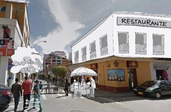
Tourist accommodation facilities in Paipa are concentrated around the geothermal and water sports assets, represented by blue and orange “bubbles.” These areas collectively form a tourist belt that is somewhat isolated from the urban core, depicted in green. An opportunity lies in extending the commercial corridor of Calle 25 to the south, which could enhance connectivity and promote tourism by bridging the gap between the tourist-centric areas and the urban center. This extension would also enable more seamless integration of local businesses and amenities, encouraging economic growth and increased visitor engagement throughout the town.


The third issue and opportunity in Paipa relates to an inadequate vehicular system and a pedestrian network that is not easily accessible. The downtown area is essentially sandwiched between the I-55 highway and the rail line, creating barriers to social and physical accessibility and dividing communities.


The dense street network in Paipa delineates five-minute walk sheds, emphasized in orange, offering a chance to restructure street hierarchy and counteract the segregation caused by the railway and highway. However, the pedestrian experience in downtown Paipa feels congested, with certain streets and alleys lacking adequate sidewalks.


Paipa is expected to grow by 10,000 residents by 2050. Without adequate facilities, stress will be placed on existing transporation, housing, and pedestrian connectivity issues
The cultural and tourist economy outside of Paipa’s urban core remains unharnessed where monuments, waterways, and cultural heritage sites remain segregated and unmaintained
After several infrastructural improvements following urban reforms in the 1950’s, physical and social barriers have persisted creating inaccesible vehicular and pedestrian networks
Plazas, parks, and recreation around water and athletics remain dispersed from linear open space systems drastically reducing access to shade and vibrant commercial corridors
Pollution to Paipa’s lagoons and creeks continue from years of coal generation that pose risks to resident’s health
The accomodation of 10,000 residents will require a demand for housing with approximately 3000 additional units to preserve Paipa’s urban and rural character
By embracing Paipa’s natural landscapes and seasonal harvests in urban designs and diverse festivals through music, art, sports, food, and fashion holds vast potential to connect people, assets, and open spaces
Paipa’s dense urban street network offers 5-minute walksheds that may be reorganized to counteract congestion and issues of walkability
By extending Paipa’s commercial corridor and cultural resources south along Calle 25 and the railway, new open spaces may bridge the gap between the urban core and tourist hubs
Along with Gensa’s announed energy switch by 2035, the preservation and development of Paipa’s scenic waterways are possible through investments in geothermal, renewable, and waste-to-energy projects
As a city of wellness, Paipa will become an equal & connected town for locals, and a resilient geotourism hub for tourists. Envisioning the next 30 years, Paipa will not only provide sustainable green infrastructure & exemplary new developments, but also offer cultural & sports events that can brand the city to the world.
EW-NS Commercial Corridor:
Water System:
Termopaipa Eco-Park
Sochagota Lake Park
Central Sport Park
Eco connection parks
Infrastructure: Rail Park
Natural System: Natural Boundary
Connectivity between Agriculture, Commerce and Tourism
Rural-Urban Synergy: Delineating town’s limits
Tourism as a Major Catalyst for Growth: Economic Diversification
Community-Oriented Development:
Empowering local community

New Development: Six Development Zones
Public Transit: Minibus Connection
Existing Corridors: Highway I-55 Calle 25
Proposed Improvements:
Pedestrian Network and Rail Park
Parking Decks

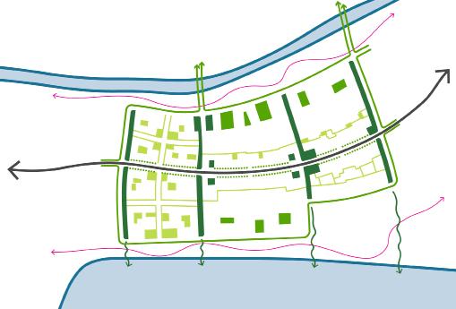
Our initial concept focuses on enhancing the resilience of the current ecosystem within our development plans. The natural features already present—hilly terrains to the north and water bodies to the south— outline the geographical boundaries of our proposed development area. The planned parks are designed to complement these existing water bodies. Furthermore, these parks will be interconnected by a proposed east-west rail park, ensuring cohesive and sustainable development.
As part of the resiliency framework, the 4 main design interventions include a proposed boundary that aims to define the extent of geographical development in the town, a protected zone to provide a natural buffer space that simultaneously ensures Paipa’s identity is independent from Duitama, 4 eco-connection parks that are integrated with the existing water bodies and a trail that connects the rural, urban and natural elements of the ecosystem.
There are 4 main design interventions. We set boundaries with rural and protected zone. The parks are proposed based on existing natural system like the lake, lagoon, river, and ditch. The trail is to connect rural, urban and natural area.


The natural boundary will be determined by the existing forest cover, the surrounding topography, and the course of the Toibita Creek. This natural demarcation will serve to protect the ecological integrity of the area while guiding future development in a sustainable manner. To the east, a designated protected area will further bolster Paipa’s resilience to future growth challenges. This zone will act as a buffer, safeguarding against encroachment and ensuring that Paipa can expand in a way that respects its natural surroundings and fosters long-term sustainability.

The red dashed line in the map represents the geographical extents of the development proposals. This boundary is in tandem with the natural features of Paipa’s landscape that include the mountains in the north and the water bodies in the south. Additionally, the Toibita creek in the east marks the beginning of the proposed protected green buffer that intends to preserve Paipa’s independent rural identity and prevent it from falling into the shadows of Duitama’s bigger urban identity.
Natural boundary (mountains and forests) - NS forest buffer boundary connection through proposed protected zone, regional trail (hiking, biking etc) also a buffer to limit city growth.
The protected area along the creek Toibita prevents Paipa from merging into Duitama in the future. It is also a way to preserve the rurality of Paipa.
The Chicamocha River Park is a transformative project forming Paipa green system structure, especially west-east connection. The park includes varying buffer widths depending on the city context, ranging from 15 meters in urban areas to 30 meters in suburban zones and up to 100 meters in rural regions. These buffer zones serve a dual purpose: they provide valuable green space for recreation while also acting as protective barriers against flooding and uncontrolled development. By maintaining a natural buffer along the river, we ensure a balanced ecosystem that enriches the local environment, promotes biodiversity, and mitigates the risks of urban sprawl.
Simultaneously, the Chicamocha River Park incorporates subparks strategically located at key river bends and sites, such as the Termopaipa Lagoon Park, Wetland Park, Central Sport Park, and a series of floodable waterfront green spaces. This sub-park network ensures that residents have access to outdoor activities, whether it’s walking, jogging, or simply enjoying the beauty of the river landscape. The Chicamocha River Park exemplifies how thoughtful urban planning can create vibrant, sustainable spaces that benefit both people and the environment.
Urban Buffer: 15m
Suburban Buffer: 30m
Rural Buffer: 100m


With the plant transitioning to cleaner energy in 2034, there’s an opportunity to transform the polluted lagoon into an educational ecopark and entertainment district.
Our first objective is to enhance water regulation and purification. we integrate the lagoon with the lake, by turing the existing underground canals into a series of wetland ponds. The vegetation in ponds will purifies the water overtime to ensure a sustainable solution echoing the energy transition. we use planting strategies to create various habitats, like marsh,forested wetland, open water, wet meadow to repair the polluted lagoon and to create diverse experiences, which is showned in section.
Next, we integrate essential facilities within the landscape, such as trails, viewing points parking areas, and an educational center. The park serves as an educational hub telling environmental stewardship. Additionally, recreational amenities enhance the overall experience.

The Central Sports Park plays a pivotal role as a dynamic hub within the city, connecting various recreational spaces such as the Chicamocha River Park, Creek Parks, and Rail Park. Not only does it provide a vibrant center for sports and leisure activities, but it also serves as a vital link between different parts of the city. Moreover, the Central Sports Park enhances connectivity by bridging the gap between urban areas and the serene beauty of the lake. Its strategic location encourages residents and visitors to engage in outdoor pursuits while enjoying the scenic views.

The Central Sports Park, the final addition to our proposed park system, holds a pivotal role in weaving together Paipa’s green spaces. Serving as a central green node, this park symbolizes the integral role of sports in shaping the town’s identity.
Designed to foster connectivity, the Central Sports Park acts as a vital link in the eastwest axis, connecting the picturesque Lagoon with the majestic Chicamocha River. In the north-south direction, it seamlessly integrates Sochagota Lake, Rail Park, and the heart of Paipa Town itself.
Recognizing the significance of sports in Paipa’s social fabric, the social economy team will delve deeper into developing an overarching sports network. This initiative underscores the town’s commitment to nurturing its sporting heritage and leveraging it as a driver for community engagement and economic growth.
To ensure connectivity and create an improved system, the extension of the lake trail increases walkable open space along the waterfront including a floating wooden bridge on the western side of the lake along private land. A proposed visitors center along the trail aims to take into account the projected growth in Paipa’s tourism industry.
By the property analysis, since the western land are private, the trail on the west lake will reach out into the lake and be “floating”, just like the precedence shows. For the trail on eastern lake, it’s waterside walkway to connect the whole loop.
We also proposed a visitor center to provide service to tourists

Existing Park
Proposed Recreation
Water Sports


In addition to the Chicamocha green spaces, the park systems along the creeks that stretch along the north-south axis in Paipa are designed to integrate recreational activities. These parks not only offer various outdoor activities for locals but also address essential green infrastructure needs at the places that overlap the flood or landslide zone, including stormwater retention and landslide reduction. Specifically, the parks along Rosales and Valenci creeks serve as vital north-south green corridors within the Paipa urban area, enhancing both recreational opportunities and ecological resilience.

The Rail Park concept harnesses vacant lands along the train tracks, transforming them into a linear park that serves as a vibrant public space for community engagement and recreational activities. This innovative approach not only revitalizes underutilized areas but also fosters enhanced connectivity between rural and urban regions. By repurposing these areas, the Rail Park provides accessible green spaces where residents and visitors can engage in various outdoor activities such as walking, cycling, and community events.
The park’s design strategically integrates natural landscapes with pedestrian pathways, creating a seamless transition that encourages exploration and interaction across different parts of the town. This development not only promotes environmental
sustainability but also strengthens the social fabric by providing a shared space that enhances the quality of life for all community members. Additionally, the Rail Park acts as a green corridor, promoting biodiversity and serving as an ecological buffer that helps to mitigate urban heat, manage stormwater, and improve air quality, thereby contributing to the overall health and resilience of the community.


The socio-economic development plan for Paipa is meticulously crafted to promote equity and stimulate economic growth through a series of strategic initiatives. Central to this plan is the EW - NS Commercial Corridor, which enhances connectivity between agriculture, commerce, and tourism, the primary economic drivers of the region. This corridor not only supports ruralurban synergy by clearly delineating the town’s limits but also facilitates integrated development across rural and urban zones. By leveraging tourism as a major catalyst, the plan seeks to diversify the economy while ensuring that growth benefits are equitably shared among community members. This community-oriented approach aims to empower local residents and uphold cultural integrity, thereby fostering a sustainable development model that aligns economic advancement with social equity and community wellbeing.
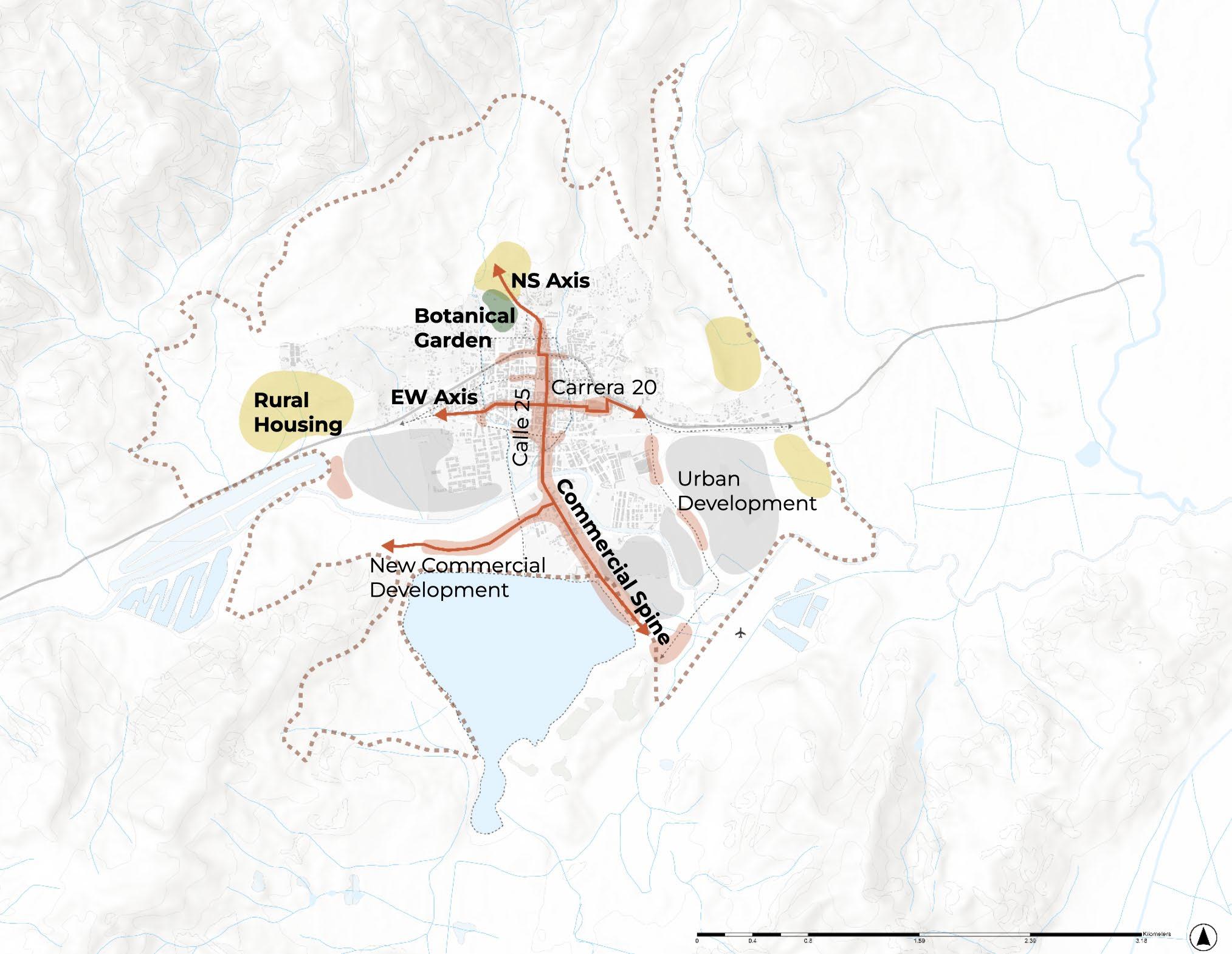
EW-NS Commercial Corridor:
Connectivity between Agriculture, Commerce and Tourism
Rural-Urban Synergy:
Delineating town’s limits
Tourism as a Major Catalyst for Growth:
Economic Diversification
Community-Oriented Development:
Empowering local community
The socio-economic development plan for Paipa enhances urban vitality with two strategic commercial corridors. The NS axis develops vibrant mixed-use areas near the lake, boosting tourism and nightlife. The EW corridor revitalizes the area around the railway station with murals and commerce, connecting rural housing to the town center. It also transforms the eastern marketplace into a farmers market and public parks, promoting community engagement and economic growth.


The public plaza, situated on slopes and featuring park-like green spaces, serves as both a vibrant community gathering spot and a peaceful urban retreat.
Our vision capitalizes on existing assets to enhance connectivity across varied spaces, addressing the diverse needs of different demographics. For local residents, daily-use areas are enhanced with health and education facilities, recreational and sports complexes, and mixed-use commercial zones to support a comprehensive lifestyle. Tourists will benefit from an extended route featuring continuous scenic views along Lake Sochagota and seasonal events by the Chicamocha River. This strategy enriches experiences for both locals and tourists while optimizing both natural and built environments to foster community engagement and boost tourism.


Institutions(Health + Education)
Heritage and Recreation
Sports and Wellness
Commerce
Triangulation of Pedestrian Flows

The proposed event clusters in Paipa’s socio-economic framework strategically introduce new venues throughout the city, diversifying event locations to extend beyond the historic core. This approach not only prevents clustering but also supports balanced urban development and cultural engagement across the community.
The placement of these venues is considerate of the town’s expansion and aligns with the proposed EW and NS commercial corridor, ensuring an integrated and sustainable growth strategy.


Incorporating rural housing into the plan addresses a fundamental need for affordable and accessible living spaces for those working in the agriculture sector. It can also help in retaining the rural population and preventing urban drift, which is critical for maintaining a robust agricultural workforce.
Additionally, by providing stable housing solutions, the plan supports the overall well-being and stability of the community, fostering long-term economic and social sustainability in rural areas.


Integrating rural housing and establishing a botanical garden in the northern part of town will boost the agricultural sector, enhance tourism, and support local farmers, fostering a thriving and sustainable community. The botanical garden serves as a key link between agriculture and tourism, creating a central hub that promotes the intersection of these sectors, thereby diversifying the economy and reducing dependence on a single industry.
Furthermore, the introduction of an Educational Center for Innovative Farming Techniques and Farm-to-Table experiences will deepen the community’s agricultural engagement, offering both educational and culinary opportunities. This strategic melding of agriculture and tourism, supplemented by educational and recreational facilities, will not only drive economic growth but also strengthen community bonds by uniting residents, tourists, and farmers in collaborative learning and leisure activities.


The culmination of our development plans rests on prioritizing connectivity as a fundamental aspect of our strategy. This entails enhancing key existing transportation corridors and integrating improvements into Paipa’s pedestrian and transit networks in alignment with the proposed development zones. By weaving connectivity seamlessly throughout our planning, we aim to create a cohesive urban fabric that fosters accessibility, sustainability, and quality of life for all residents and visitors alike.
Our attention will be directed towards enhancing the existing crosstown highway, I-55, and the bustling pedestrian thoroughfare, Calle 25, to elevate the quality of life for our community members. Additionally, in response to urban expansion, we have identified six strategic development zones for new housing and mixed-use projects.


These zones are situated south of the rail park and north of Lake Sochagota, aiming to effectively manage and accommodate the city’s growth while preserving its natural landscapes.
As part of our development strategy, we propose implementing a unified minibus system to enhance connectivity along the north-south (NS) and east-west (EW) corridors of Paipa. This system will be designed with careful consideration of existing regional bus routes and anticipated commercial and residential expansion in the area.
By integrating seamlessly with the broader transportation network, the minibus system aims to improve accessibility and mobility for residents and visitors while supporting the sustainable growth of Paipa.


The enhanced connectivity strategy encompasses expansions to the current road infrastructure, encompassing both vehicular and pedestrian-oriented thoroughfares. In response to on-street parking challenges, the proposal introduces two new parking decks located near the roundabouts, which can be seamlessly linked to the public transit network.
These facilities serve to support pedestrian pathways and enable commuters to disembark from buses or vehicles, accessing the city center within a brief 10-minute timeframe.


To better connect the areas on both sides of highway I-55 (Carrera 24), we propose a series of traffic calming measures at major intersections. In this way, we can slow down crosstown traffic and let people safely cross the wide street. These measures include signages, lighting, traffic lights, pedestrian crossings, sidewalk bump-outs and pavements. They’re all relatively affordable approaches and can be implemented in the short term.


In the long term, Paipa has a potential to build a crosstown tunnel under the existing highway and between two roundabouts. With the tunnel, the crosstown traffic can be completely isolated from local traffic and pedestrians, which provides more space for wider sidewalk and active pedestrian activities along I-55. However, this approach is very expensive and time-consuming, so it won’t happen in the coming decade.


The long-term alternative is to move the highway and meander it all the way towards the southern tip of the Sochagota Lake, directing the major traffic away from downtown Paipa. It’s similar with the approach near Tunja, where the government built a new highway (I-55B) at the outer ridge of the town, and reduce the crosstown traffic on existing I-55. In this way, the existing highway (Carrera 24) will be turned into a boulevard, with thriving retails and public activities. This approach is also quite expensive and may affect some private properties south of the lake


This proposal prioritizes pedestrian traffic by implementing traffic calming measures along I-55 and widening the sidewalks. By incorporating tree pits and green buffers on both sides of the road, along with green medians, I-55 transforms into a verdant boulevard. This redesign not only creates additional space for on-street activities but also fosters a safer and more enjoyable pedestrian experience.

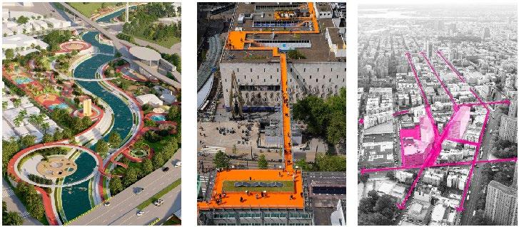
This is a bike path case study in Bogotá. There are few types of bike lanes suitable, for example the central duo-lane bike lane embedded within the boulevards that we are proposing, and also the shoulder bike lanes among secondary roads.


The group propose to turn it into a green boulevard. Through infill and streetscape improvement along informal structure along the rail line, it may free up enough space for a two-way bike path and green buffer.


In the plan, ont only Calle 25, but also Calle 22, Carrera 20 & Carrera 22 will become a pedestrian-only street, taking the section of Calle 25 as the pedestrian street typology. Wide sidewalk and active storefront are on both side of the street, while two-way bike lane is located in the middle.


Continue going south, after Calle 25 crossing the bridge on the Chicamocha River, the bike path is combined into the west side of sidewalk, making it a multi-model path. When cyclists ride by the Sochagota Lake, which is also on the west side of Calle 25, people can stop by, and enjoy the scenery.


The projected growth of Paipa’s population will require 3000 additional units of housing by 2050. Futhermore, the town’s potential lies in the health and wellness of Termopaipa and its waterways to mediate pollution and altogether creating new waterfront views. The following student proposals regulate new urban typologies that incorporate the region’s unique dry and rainy seasons, while regenerating diverse open space zones linking residents and tourists alike to new opportunities that face waterways, railways, and I-55. Housing, economy, and ecology
remain the guiding themes. By adding additional income to residents through renewable energy production and renewing human activity between rural and urban, natural-based design solutions retain the integrity and resiliency of the town’s cultural history and local community. Finally, the pedestrian experience is prioritized through a series of educational hubs, mixed-use commercial zones, and sustainable landmarks. As a whole, urban design is meant to steer enduring urban development that boosts the areas appeal and offers feasible strategies for Paipa’s future.

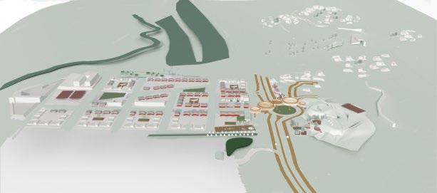
The Western Gateway District, nestled between the pastoral uplands featuring hotels, forested creeks, and horseback riding clubs near Termopaipa, and the private farmland adjacent to La Estacion’s social housing in the lowlands, is characterized by its rolling hillsides and the traffic of I-55. The district off ramps onto a commercial strip with restaurants, tree nurseries, and converted single-family homes. To integrate urban and rural elements and address the challenges posed by highway traffic and underutilized


open spaces, the proposal envisions a sculptural gateway that serves as Paipa’s western entrance. This plan transforms existing forestry into park space, enhances pedestrian and animal pathways along I-55 with new roundabouts and a pedestrian bridge, and adds scenic viewing platforms, a museum, and a library. It also introduces fitness centers and electric vehicle charging stations. These attractions and open spaces support the development of a high school, 170 mixed-use residential units, and 29 detached single-family homes equipped with community gardens and playgrounds, all framed by two wetland parks.
Zooming into the site, the roundabout establishes new north/ south connections towards the entertainment district and natural recreation areas with a central green median the pedestrian space on either side of the highway measures 15-25 meters unto which new sidewalk and grazing space are allocated. The northern greenspaces are proposed as entryway to the nature trail through green platforms and open air market and muic facilities. The library and museum have galleries and plazas on the ground level

forming the porous block structure of mixed-use apartments facing the roundabout. The top floor of the museum and natural park serve as the landings of a 24 meter elevated pedestrian bridge. This curvilinear sculptural bridge mirrors the sloping landscape and sweeping clouds, bridging nature and cultural activity. This elevation offers new sights of the entertainment district and new mode of travel for residents in the north headed south for work through the nature trail. Finally, the electric vehicle (ev) charging


station and cafe equipped with playscape and fitness facilities sits on the edge of a greened creek and wetland park.


This facility offers respite to tourists with a display of passive recreation complemented by adjacent grazing gardens. The subsequent perspectives depict an east to west approach of the roundabout, starting from the market and music plaza and ending with the ev charging station and natural park. The music plaza adjoins the market, creating a refuge between the commercial strip and the nature trail and park. The proposed roundabout acts as a traffic calming element alongside widened sidewalk in addition to grazing and green space for outdoor market activity. The grazing spine is developed using 3 proportional sizes of flora for grasses, mid-sized monocultures, and large trees to allow
pasture as well as shading for humans and animals. South of the roundabout are new four-story library and museum which form arcades to produce gallery space on the ground floor and frame Paipa’s scenic lakes and mountains. The glass facades of the library and museum allow a voyuer into the new animal and human activities harmonizing on the ground floor. Green platforms lead users towards the summit of the hilly park and recreation spaces joining the nature trail to the entryway to the elevated pedestrian pathway.


The site may be analysed across green-blue, mobility, and housing armatures. 30 meter buffers around two creeks forming the edge of a graded forest trail as well as green plazas set at the center of five rural housing clusters make up the green system in the uplands. The edges of Termopaipa are wooded which extend alongside the grazing spine on the I-55 highway. In the lowlands, each housing block consists of green enclaves or community gardens for
residents as commercial space serving as green moments westeast of rain gardens and wetland park.
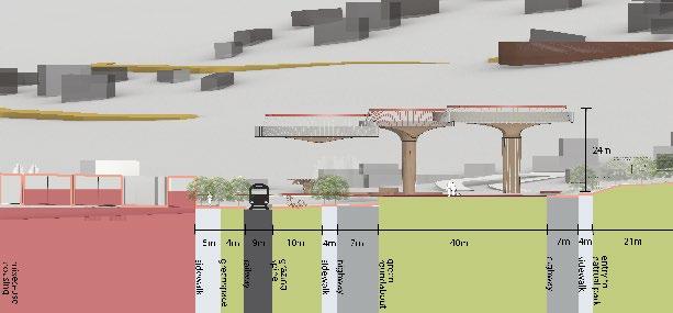
Two neighborhood parks coalesce greenspace along the northeast and southwest axis of the neighborhood. The blocks of the gateway district are divided into several configurations of sixty-five by sixty meter blocks, mirroring the block dimensions within Paipa’s urban core. The main commercial street, which connects to the roundabout, is 9 meters wide with 4.5 meter wide sidewalks. Roadways oriented eastwest are approximately 9 meters wide. The pedestrian walkway spans approximately 120 meters across the highway ranging between 10 and 21 meters in width.
Proposed housing in the uplands includes thirty-four units of productive housing. These clusters derive nieghborhoods joined by buffered creeks with graded viewing


decks. In the lowlands, 179 two-story mixed-use units face the main street running north/south from the roundabout the northwest and southeast axis and the rain gardens. The 29 one-story single-family detached units face the highway and buffered creek. A movie theater and highschool sit in the south along the Chicamocha River.


Qianyun Wei
Qianyun Wei
Situated in the heart of Paipa, the Paipa Line is a visionary linear park that transforms vacant lands along the existing railway into vibrant open spaces for community activities, enhancing connectivity and fostering urban and rural integration.
3.2 HA OPEN SPACEThis strategic development not only links east-west urban and rural regions but also bridges the north-south divide created by the train tracks, knitting together all open spaces within the town. The Paipa Line is poised to become a key transportation hub, drawing tourists and workforce from neighboring areas. Key features
3 HA OPEN SPACE

include the Paipa Station (regional rail) and East Paipa Square (light rail and mini-bus), which will expand public transit options, alleviate traffic congestion, and become a dynamic landmark that attracts foot traffic and stimulates economic activities.
2.2 HA OPEN SPACE
2.6 HA RESIDENTIAL
0.6 HA COMMERCIAL 0.2 HA OFFICE
0.85 HA HOTEL
0.4 HA SCHOOL
1 LIGHT RAIL + MINI BUS STATION
Rendering - Paipa Station Landing


Rendering - East Paipa Square

5-10 YEAR Section A - West Expansion Park
Section B - Paipa Station
The development of the entire Paipa Line is strategically phased to enhance downtown walkability and attract visitors over the next two decades. Initially, within 5-10 years, urban plazas, light-rail and mini-bus station, coupled with a hotel, will be developed to boost local foot traffic and encourage longer stays. In 10-15 years, following the introduction of regional rail, the Paipa Station Landing will be established as a grand entry point that leaves a lasting impression on visitors. Concurrently, mixed-use neighborhoods will be constructed to provide spaces for living, working, and leisure, catering to the growing population. In the 15-20 year timeline, the west expansion park will be developed to link with the Termopaipa Eco Park, aligning with its planned energy shift in 2035. Additionally, if housing demands increase, a residential neighborhood south of East Paipa Square will be initiated. Overall, the Paipa Line aims to offer a broad array of open spaces and varied building uses that support daily life for both locals and tourists, effectively removing barriers created by the rail lines.


The site is strategically located at the heart of Paipa’s core, bordered by a railway and a creek. It serves as a vital link, stretching from the commercial center to the surrounding neighborhoods, both east-west and north-south. This area is part of a new development zone in central Paipa, which capitalizes on the opportunities along the Paipa railway line. Not only does this zone encompass historical assets and event spaces, but it also aims for a seamless integration with Calle 25 over the coming decade. Considering the anticipated population increase, the upcoming railway district is poised to expand into vibrant, walkable clusters that combine central commercial and service functions. This development is designed to foster connections with the peripheral communities, enhancing accessibility and community integration.


The structure is centered on the historic railway station in Paipa, which is both a historical heritage and a transit center for future tourists and passengers. The open space system complements the development of the railroad park and is interwoven with the recreational areas along the creek, thus becoming a major attraction and municipal function area. As a result, major new development has taken place along the railroad and creekside in the form of new civic spaces. In addition to this, there are a number of street regeneration programs, particularly in the northeastern portion of the District, which aim to improve the streetscape while further connecting to the commercial core to the east.


The redevelopment plan begins with revitalizing the historic railway station, railway plaza, and establishing a tourist center. A railway park, designed to run parallel to the creek, will integrate into the urban landscape, accompanied by new market-rate housing along the creek. An open space system will connect the station with nearby residents and extend creek activation north and south. Additionally, the railway plaza will merge with a green park in the social housing zone, effectively linking to the currently isolated southern railway area, enhancing urban cohesion.


The rendering depicts a vibrant atmosphere at the landing point for both tourists and residents, featuring a large open plaza that hosts a range of activities, from seasonal cultural events to daily recreational functions. Its proximity to the creek and railroad not only enhances engagement with these historical and natural elements but also enriches the visitor experience. Across the creek, residential areas with ground-floor retail spaces create lively interfaces between buildings and people. On the opposite side of the railroad, the open plaza extends into public spaces, further connecting the open space system towards the social housing area, fostering a cohesive urban environment.

There is a need of reweaving Paipa’s rural and urban areas by introducing a wayfinding linear park that defines the path hierarchy and linkage.

Case Studies:
My concept came from several existing case studies and projects. These include the Rionegro riverside walk project in Colombia, the MVRDV’s vibrant Rotterdam rooftop walk in the Netherlands, and the open space thread system in Manhattan, New York. All of them seeks to redefine urban public space with a sign of passageway.

The threads act as media for an enhancement of pedestrian experience. With these threads meander along the green elements, it generate various functions such as commercial, river walk, sports, spots for picnic, leisure, community events, chess, and cultural landscape.


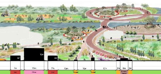
The masterplan begins north and diverges from the Paipa Line rail park. The primary thread meanders across the site with secondary threads spread towards east and west, connecting neighboring parcels. The River Loop above the Chicamocha River provides a brand new pedestrian experience.


The design strategy is to strengthen north-south-eastwest connection to the existing residential and commercial neighborhoods. Threads improve linkage to existing parks, but also foster mix-use and institutional growth for Paipa. The north parcel consists of a narrowing commercial neck where residents enjoy fritanga food markets and picnic space. The sports facilities provide extra vibrancy to the west corridor. With the addition of the botanic garden on the east, the residents gain the opportunity to experience and explore the variety of South American plants and species. The south parcel provides mixed-use offices and malls, strengthening local economy.
These threads can be a variety of typologies that serve as different functions, such as urban public space and rural agriculture. Threads would become the identity of Paipa’s open space, a cohesive symbol of passageway as they flow among the urban elements. These threads can also serve as commercial markets (the fritanga food stall) and creek and stormwater management facilities that flow alongside the water body.

The north parcel provides commercial corridor and a botanical garden that effectively boost agriculture sector, simultaneously promoting tourism.

The existing site is a uncultivated semi-public land bounded by the existing social housing Estacion.

The Valenci Creek is an essential water spine that flows from urban fabrics to Chicamocha River. The condition, however, is in need of redevelopments.

The south parcel provides an education center and agriculture that benefits local farming, thereby contributing to a thriving and sustainable paipa.

The Chicamocha River that splits this site into north and south parcel is under-maintained.

The Rosales Creek begins north and penetrates across urban fabrics, flowing trhough some of the most important urban districts and eventually into Chicamocha River.


Note: Since the park serves as a recreational spine for surrounding residential, no further residential space is allocated within the park.

The site is located in a crucial central linear spine that connects urban to the Sochagota Lake.
Here are some infrastructure redefined for my project:
1. Redirect Valenci Creek and converge with Rosales Creek
2. Confluence ensures sufficient water flow during dry season and serves as downstream stormwater management during wet season
3. Extend two streets with side parking and strengthen eastwest connection


Section AA’
The mix-use offices stand at 10 meters in height. The River Loop provides bridges and observation decks for residents to interact with water. Each thread and passageway has a different elevation, which further upgrades the diversity of walking experience.
Section BB’
Alongside the commercial corridors, food stands and fritanga markets combined with creekside walking and kayaking creates a multitude of vibrant activities. The threads further stretch into existing residential units, fostering the idea of coxistence of urban fabrics and greenery.
Section CC’
Looking south towards the Sochagota Lake, the observation platform next to the lakefront provides a unique aerial view of the entire lake. A variety of kids playground, tree houses, water fountain plazas, and gateway plaza elevates the waterfront atmosphere. The Indigenous Plants Observatory offers an educational approach and activities to learn about Colombian flora. The agriculture land invites local residents to self-serve and experience cultivation.


Our site, on the south edge of downtown Paipa, is located between two important natural nodes: Sochagota Lake and Chicamocha River. As one of the six development zones defined by the masterplan, it’s also on the south of some existing social housings and the proposed sports belt.
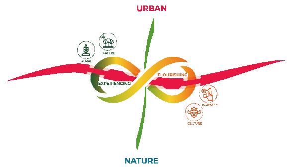
We see the site as an important node that connects urban and nature. With the valuable natural assets, it’s a nice place to propose a paradigm for Paipa’s urban expansion. Therefore, we’d like to propose a new town at this location, with the concept Experiencing & Flourishing.
For experiencing, we hope the future residents and potential visitors can fully experience the scenery in the town, no matter they’re sitting, strolling, or cycling. Moreover, we want to preserve the rural spirit of our site, and recreate this feeling in people’s daily activities, such as farmer’s market and fruit picking.
For flourishing, we aim to stimulate economic growth through new developments, which include housing projects and mixed use clusters. In the meantime, it’s important to preserve local’s living tradition, so we also propose spatial strategies to better shape local neighborhoods.


“Experiencing“ is shaped by open space system. This diagram represents the open space hierarchy, there are 3 layers of green fingers: (1) green belts - connecting river and the lake;(2) street trees - along the traffic corridor;(3) alleys - allow residents to stroll in the neighborhood.
We also propose 3 layers of green patches: (1) Green plazas, which are more public; (2) Community gardens & waterfront parks, which are more private; (3) Private yards, which are attached to housing units.


Neighborhood-scale: Green Belt, Street Trees, Waterfront Parks
Neighborhood, Block and Pacel-scale

Stakeholders:
• Developer & Government
• Tourism Department (planting & harvest events)

Block-scale: Community Garden, Community Alley

: Private Yard


• Community Organizations
• Residents
Stakeholders: Stakeholders:


• Residents


On the waterfront, there’re bike trail and various recreation facilities. People can cycle from the Central Park to the town, and enjoy gorgeous natural scenery.
Green belts give people the feeling of social & urban mix. With the bike path, it’s easy for cyclers to ride their bikes from the river to the lake. The wide sidewalk and parallel parking can also boost retail activities.

“Flourishing“ is another concept. We want to introduce mixed use to activate local businesses, as well as preserve local traditions. These mixed use frontages are mostly along Canocas, and near the two important intersections, which are also the proposed locations of minibus stops.
There’re 4 types of blocks in our site. We understand that Colombia’s zoning code follows several stratums, so all 3 types of the residential blocks are aligned with residents’ income level.


• Flexible function & space
• Equal Pocket parks for retailers
• Fruit Picking Experiencing

• High density footprints
• Equal Community garden • Small yards

• Large open space with local


Existing
Apart from the mixed-use cluster, the proposed development also offers sufficient housing supply. There’re about 700 to 800 new housing units in our site, which includes around 240 social housing units. With the new housing units into the local market, it can definitely benefit Paipa’s growing population.
Considering the booming tourism, we also locate two hotels for the new town. The hotel facing the lake has the best scenery, and the one on the northeast corner has more urban feeling.
To better control the density, building heights are lower near the lake, and higher near the river. Thus, the town shapes a skyline that steps down from the downtown side to the lakefront space.

In community gardens, residents can relax, run their dogs, and enjoy fruit picking in their spare time.
Along Canocas, which is the major traffic corridor, we plan to widen the sidewalk, add green buffers, and have parallel parking on both sides of the street. In this way, pedestrians may have better experience, and local retailers have more space for their businesses.


The location of the site lies between a lake and a river. How to handle the relationship with the lake and river is the main theme of the design. One major principle that is adhered to throughout the entire development process is to protect the river, including safeguarding its groundwater resources, hence the establishment of setback lines. How to ensure that the river contributes positively to urban development within this framework is the main focal point of the design.

Based on the erosion and deposition spaces of the river, this plan adopts different development strategies. On the eroding bank where the slope is steep, and the ground is solid, public service facilities are arranged. On the deposition bank where the slope is gentle, it can be developed into green spaces for citizens to enjoy.


The section represents the current relationship between the city and water, which is developing with its back turned to the water.
After the improved design, residents can go down to the water’s edge and interact with the water. At the same time, the river has been widened, enhancing its ability to handle floodwaters, making the city more resilient. This is the design for the eroding side. After improvement, buildings have been elevated to provide users with a view of the waterfront. Additionally, public facilities have been placed along the water’s edge to attract residents to engage in activities by the river.

This is the overall layout plan of the design, showing the two different design strategies implemented on the eroding and deposition banks. Looking at the whole picture, as people progress southward from Calle 25, they will encounter hotels and commercial clusters developed along the river. As people turn towards the river, they will reach a large urban park and a traffic roundabout. Continuing along the river, people will come to a linear flood levee walkway. Walking northward along the levee leads to the new community center, which includes schools, churches, and a community farm.


The flood embankment and sports park are adjacent to the community. Both residents and visitors can come here for activities. The hotel and commercial cluster are by the lakeside. The hotel has multiple floors, allowing guests to enjoy panoramic views of the lake. The rooftops of the commercial buildings can be turned into rooftop gardens for the hotel, providing another vantage point to enjoy the lake view.
Residential block
Total Units in one block: 40
Total Parking spaces in one block: 40
Height: 30ft
Total number:16

Mix-use block
Total Hotel floor area in one block: 34,200ft2
Total Retails floor area in one block: 11,700ft2
Total Parking spaces in one block: 10
Height: 72ft
Total number: 6


Riverside spaces are planted flowering trees, making it a beautiful urban scenery. Distinctive public buildings are placed along the new embankment, revitalizing the riverbank and allowing people to experience the natural beauty of the Paipa riverside.
The hotel cluster is designed open squares and hotel parks for the public, aiming to maximize the public accessibility of the lakeside.The new architectural cluster emphasizes directionality, with community greenways crossing the cluster towards the southwest and northeast, leading towards the lake and the river.
The proposal tackles key challenges in Paipa, including excessive reliance on unsustainable paramo agriculture and a significant shortage of social housing, while aiming to rejuvenate Muisca indigenous culture. It also addresses site-specific concerns such as restricted access along Calle 25 to Sochagota Lake and the inefficient use of vacant lands and event spaces.
The site plan for the site strategically combines mixed-income housing, community amenities, and lush green spaces into a pedestrian-centric network that enhances cultural heritage and promotes robust community interaction, while also fostering a sustainable, walkable community thriving on mixed-use development and ecological richness.


The section showcases the transformative strategy for Calle 25 and the adjoining lakefront area, emphasizing the integration of urban vibrancy and connectivity. The design features a lively lakefront promenade complemented by a cultural center that honors Muisca architectural heritage, with a focus on mixed-use developments along Calle 25 to enhance the urban experience. This approach not only revitalizes the area but also strengthens the community’s connection to its cultural and natural resources.

The innovative mixed-income housing model employs a plugin frame structural system that allows for incremental growth and adaptation to residents’ changing needs. Housing units are strategically organized around communal courtyards, promoting enhanced community interaction and pedestrian connectivity between blocks. This layout integrates smoothly with vital services such as childcare and small businesses, all set within a sustainable urban environment.
The courtyards not only serve as green spaces for relaxation and socializing but also play a crucial environmental role. They are designed to maximize natural light and facilitate cross ventilation. The integration of local vegetation contributes to the microclimate of the block. This approach ensures that the development not only meets the current needs of its inhabitants but also adapts to future environmental and social changes.
The creek is transformed into a vibrant pedestrian spine with mixed-income walk-up apartments, artisan studios and workshop spaces to promote Paipa’s cultural arts and handicrafts. A major design intervention is the naturalisation of the creek, removing the concrete which would ultimately mean an increase in width perhaps, and providing plants alongside to allow water to permeate through, to reduce storm water runoff and also filter the water through plants, soils and stream gravel for cleaner water flow.


Walk-Up Apartments
Artisan Studios with Workshops
Creek Naturalisation Pedestrian SpineShuting Li


Termopaipa coal power plant is one of the biggest power plants in Colombia. It generates 8% of the electricity of the whole country, which brings numerous revenues to the city. The plant is located on the outskirts of Paipa town, approximately 2,400 meters away from the city core (fig.1). The giant plant is situated among nature landscape and at the upper reaches of Chicamocha river, which put environmental risks to the city.
Next to it, there are two lagoons, providing cooling water to power plant. Chicamocha river runs between these two polluted lagoons (fig.2), which is quite unique. Paipa has 2 dry seasons and 2 rain seasons year round. However, due to artificial control of two water gates, the site doesn’t have flooding issue.
The pollution caused by plant has brought multiple harms to nearby villages, including health threats, like asthma, production cut in their primary industries of livestock and agriculture, and the loss of opportunities in sports tourism.
Looking at the plant itself, there are 5 components (fig.3). Within them, waste dumping site and cooling lagoon are the 2 major sources of pollution. A severe ash emission in 2001 made residents and government aware of the negative impacts of power plant and expected for an energy transition. Thankfully, Gensa, the plant owner, announced an energy switch plan starting from 2035, which can be a great opportunity for the city.
Based on Gensa’s plan, I set four goals for the next 15 years. They are site recovery, transition to solar power, empowering locals, and boost innovation & tourism hub in this site. In my design, the 170-hectare termopaipa region consists of 3 zones: sustainable power plant, rewilding lagoon and nearby village (fig.6). To achieve a sustainable future, I design 3 layers: nature, energy, and living (fig.7). I will explain them one by one.

To rewild lagoon by nature-based solutions,I reference 2 types of landscapes. I tend to build a smooth transition by using diverse water typologies, from lake to wetland to ponds, like the picture shows (fig.4). Also, I try to create a dynamic landscape that can accommodate dry and rain seasons. I take inspiration from oxbow lake (fig.5), whose channel changes with time.

To break the current rigid layout of river sandwiched by lagoons, I remove the southern dike to create a larger area of wetland system, which can recover the environment and increase biodiversity. I keep the upper lagoon isolated to hold water sports activities. These two actions form the site with two different atmospheres, active and peaceful. Besides lagoon and wetland, I also has widen the river and create green buffer along the river to reduce flooding. There is a series of ponds with emerging plants in them to purify the water and can be used as drinking water source village (fig.10).
Move on to the water system. During the rain seasons, water flows through both river channels and wetland to avoid flooding. In dry seasons, the gates under trails, shown in axon, will be closed. So, the water is restricted within the river channel (fig.11). At this time wetland will turn into semi-dry wetland and wet meadow.
I also apply multiple habitats to build ecological resilience. Forests, at the edge of water feature, can fix the soil. Marsh, shrubs, meadow can create multi-layer niches to increase biodiversity (fig.12).
The seasonal section (fig.13) can better show the water system and yearly changes. Summer and winter are rain seasons. Spring and fall are dry seasons. Seasons affect water level and landscapes. The enclosed lagoon and river, in the first two columns, can maintain a stable level in all seasons due to the water gates under trails. But, wetland performs two varied scenarios. In fall there barely have water. For winter, it is abundant.
Master Plan
1. Solar Educational Park
2. Substation
3. Water Supply Facilities Plaza
4. Water Sports Lagoon
5. Dock
6. Seasonal Wetland
7. Purifying Ponds
8. Education Center
9. Parking Lot
10. Solar Farm
11. Community Center
12. Sochagota Lake
13. Pasture 14. Chicamocha River


Habitats varied scenarios. In fall there barely have water. For winter, it is abundant.
Zooming into wetland (fig.14), we can find its ecological restoration and preservation functions. Seasonal change can form rich subhabitatshabitats for wetlands, including wet meadows, shrubs, marsh, forest, and open water.

Water System


Seasonal change can form rich subhabitat for wetlands, including wet meadows, shrubs, marsh, forest, and open water. These diverse habitats can be a home for native animals and even save endangered species, like crab-eating fox, golden-winged sparrow, Colombian chachalaca.
Solar power plants require 20 times land than coal power plants to install solar panels. However, Termopaipa doesn’t have space for it. To acquire the land, I propose a solution by establishing a framework between the nearby village and Gensa (fig.15). Villagers can provide their abundant pastureland to install solar panels, which is also called solar farm. For return, Gensa will provide financial supports and free electricity, and professional training to empower the residents. On the plant site, a solar park will be built to generate energy and provide recreation function to both residents and tourists.
Here are two scenarios (fig.16) that can better explain these two types .


types of energy generation patterns. Left is the solar park built upon damping zone. It has trails and open space weave through solar panels. This can be a chance for people to expose and learn about solar power systems. The college on the right is solar farm. Solar panels will not largely influence livestock on pastureland. By doing this, farmers will have an additional interest stream. The electricity will be partly conveyed by grids to substation, partly serve directly to villagers.
Looking at the overall solar park (fig.17), I still I retain some of the facilities, like water supply facilities and warehouses, turning
water supply facilities and warehouses, turning them into a water supply park and an educational center. For solar farm, I only convert pasture near the hills to avoid village losing its rural identities. Upon this system, I also set transmission grids to convey electricity to substation and then to Paipa town (fig.18).
Knowing this is a big move that needs jointed efforts. I find some external partners (fig.19), like national government of Colombia, U.S Agency for International Development(USAID), and Climate Investment Funds(CIF). Currently, they all have relevant programs or policies to support energy transition in Colombia. In Colombia National Energy Plan(2020-
Energy Generating Scenarios
2050), the country enactd legislations to provide benefits and subsidies to energytransforming enterprises. USAID founded several workforce training programs to give technical guidance.
Collaborative Framework


These resources can be leverage points for Paipa government advancing the energy transition and achieving my vision.
Energy System Structure
Geospatial Distribution
Transmission Grid


Currently, the nearby village is shaped by two horizontal primary roads. However, the secondaries roads don’t form a complete circulation. Along the roads, 1-to-2- floor houses were built, creating a low-density pattern.
My goal is to develop the village for tourism purposes, but still preserve its nature characters. To achieve this, I build a natural belt with pastures and ponds (fig.20), which separates the village into two parts. For the north griding zone, I turn the main road into a vibrant corridor connecting the proposed lagoon park with downtown and completing the secondary roads circulation (fig.21). I keep the existing grid and increase the housing density for future tourism demands. The south natural zone is guided by


an idyllic corridor with ponds and pastures (fig.21). It mainly serves local residents. I follow the natural structure to build settlement clusters.
I choose two pilot sites (fig.22) to further explain the differences. In north pilot (fig.23), I vitalize the commercial corridor by inserting a series of plazas and pocket parks. Buildings along corridor are raised to three floors. The first floor is used for retail. While the main road provides services boosting tourism, the back road still ensures a quiet environment for residents. In south pilot (fig.24), natural clusters attach to the corridor. Each cluster has a functional landscape in the middle to support residents’ life. The center block with community center, water treatment tanks, main pond, is the connecting point for all clusters.
The whole site owns sound amenities, (fig.25) of parks, education centers, plaza, sports lagoon, linking by trails. These places can host festivals and events for tourists and residents to enjoy. Among them, sports lagoon and educational wetland park demonstrate two different vibes of water features. Sports lagoon (fig.26) is equipped with dock, plaza which can host diverse water activities like canoeing and triathlon to boost tourism. The wetland park (fig.26) will be a perfect place to observe and immerse in nature. It also has educational functions by building trials, bird watching spots and placing popularization panel.
To conclude, Termopaipa can have a sustainable and thrive future by integrating nature, energy and living.
https://www.booking.com/hotel/co/acosta-hacienda-del-salitre. html, https://www.istockphoto.com/photo/colombia-hot-thermalsprings-at-paipa-gm473133618-64581191
https://ellagohotel.com/catedral-principal-de-paipa/?lang=en
https://www.facebook.com/events/parque-jaime-rookpaipa/xix-festival-de-la-ruana-el-pa%C3%B1ol%C3%B3n-laalmoj%C3%A1bana-y-el-amasijo/214220345725003/
https://www.instagram.com/explore/locations/423091506/ concurso-nacional-de-bandas-musicales-paipa/
THE 10 BEST Paipa Spa Resorts 2024 (with Prices) - Tripadvisor
Estelar Paipa Hotel Spa & Centro de Convenciones Pet Policy (bringfido.com)
Review and formulation of the basic territorial land organization plan of the municipality of Paipa - Boyaca
https://www.facebook.com/taxturisticopaipa/
https://publications.wri.org/citiessafer/
https://www.pavementsurfacecoatings.com/traffic-calming/
https://ctre.iastate.edu/
https://www.pinterest.de/pin/409194316114281737/
https://www.bnamericas.com/en
https://commons.wikimedia.org/wiki/File:Paipa_Sochagota.jpg
https://www.istockphoto.com/photo/boyaca-piapa-town-incolombia-based-in-mauntain-range-gm1304087303-395355369
https://en.wikipedia.org/wiki/Paipa-Iza_volcanic_complex PAIPA REVISIÓN GENERAL DEL PLAN BÁSICO DE ORDENAMIENTO TERRITORIAL
https://www.noscogiolanoche.tv/alerta-por-incendio-forestal-enpaipa-boyaca-que-completaria-24-horas-activo/
https://956fm.boyaca.gov.co/
http://architectureau.com/articles/future-park-imaginingtomorrows-urban-parks/
https://landezine.com/broparken-by-white/
https://www.lapatria.com/publirreportaje/gensa-finaliza-un-anode-muchos-retos-y-consolida-grandes-expectativas-para-el
https://en.casacol.co/digital-nomads/botanical-gardens-medellin/
https://prevaricacion.org/atando-cabos/
https://www.facebook.com/ photo/?fbid=3153108904799707&set=pcb.3153111438132787
Beautiful Paipa, Colombia | From the Top | Flickr photo/?fbid=3153108904799707&set=pcb.3153111438132787
https://storymaps.arcgis.com/stories/ c7bb0d83f2d04beeb14c83b47b68b039
https://www.city-facts.com/paipa-paipa/population
https://www.salaryexpert.com/salary/area/colombia/paipa
https://oxfordbusinessgroup.com/reports/colombia/2019-report/ economy/ready-for-take-off-the-peace-dividend-and-new-sectorinfrastructure-are-fuelling-growth-in-the-number-of-annualarrivals
https://www.wikiloc.com/mountain-biking-trails/paipa-reservarancheria-paipa-24895803
https://www.bloomberglinea.com/2021/12/07/el-emblematicoqueso-paipa-esta-en-riesgo-por-la-crisis-de-lecheros-encolombia/
https://www.facebook.com/events/parque-jaime-rookpaipa/xix-festival-de-la-ruana-el-pa%C3%B1ol%C3%B3n-laalmoj%C3%A1bana-y-el-amasijo/214220345725003/
https://www.instagram.com/explore/locations/423091506/ concurso-nacional-de-bandas-musicales-paipa/
https://www.instagram.com/p/CjIQIRZOTnx/?img_index=1
https://www.instagram.com/p/CUNhsABrrHJ/
https://www.revistaecoguia.com/secciones/ecoagenda/296-paipasede-del-ii-festival-de-papas-nativas
https://www.tomplanmytrip.com/travel-to-colombia/destinationsin-colombia/boyaca-around/paipa/
https://periodicoeldiario.com/los-mejores-paisajes-de-aquitania/
https://twitter.com/SolzaSas/status/1362888357521588226
https://www.liveauctioneers.com/price-result/2-narino-and-1muisca-pottery-footed-bowls/
Culture Muisca - Le Temple du Soleil de Sogamoso