Resilience and Recreation
Conceptual Designs for D.W. Field Park
 B Ervin & Audrey Logan The Conway School Spring 2023
5
CONTENTS
3
15
33

19
38
ACKNOWLEDGEMENT
Thank you to the D.W. Field Park Initiative for involving the Conway School in their efforts, and to all the community members who shared their memories, hopes, and dreams for D.W. Field Park.
Special thanks to Rachel Bruce (Wildlands Trust), Tim Carpenter (Brockton Parks Department), Bill Fitzgerald (Avon Department of Public Works), Scott Turner (Environmental Partners), Ulisses Varela (Brockton Parks and Recreation Commission), and Joanne Zygmunt (D.W. Field Park Initiative/Old Colony Planning Council) for their time, insights, expertise, and passion for this project.
PROJECT INTRODUCTION Client & Project Overview Project-Wide Existing Conditions
HISTORICAL & REGIONAL CONTEXT Indigenous History Park and Brockton History Environmental Justice Zoning, Transportation, & Access to Open Space Land Cover and Climate Change
SITEWIDE ANALYSIS Geology & Soils Wildlife & Habitat Water Circulation & Park Use Community Engagement
10
OAK STREET PARKING LOT
Conditions & Summary Analysis
Design Alternatives Revised Design Design Illustrations
Existing
Preliminary
TOWER HILL PARKING LOT
Conditions & Summary Analysis Preliminary Design Alternatives Revised Design Design Illustrations
WALDO LAKE BEACH
Conditions & Summary Analysis Preliminary Design Alternatives Revised Designs Design Illustrations
AMPHITHEATER Existing Conditions & Summary Analysis Preliminary Design Alternatives Revised Design Design Illustrations
Existing
23
Existing
29
DESIGN STRATEGIES Green Infrastructure Bioretention & Wetland Plants Traffic Slowing Techniques
ROAD SECTIONS Entrance Road Northeast Road
36
PRELIMINARY COST ESTIMATES Oak Street Parking Lot Tower Hill Parking Lot
WORKS CITED
40
CLIENT & PROJECT OVERVIEW
In 2022, a multi-year initiative was launched to revitalize the “gem” of Brockton: D.W. Field Park. At 650 acres, this expansive green space is the largest park for passive recreation in Brockton, Massachusetts. Sitting partially in the neighboring town of Avon, D.W. Field Park serves residents of both Brockton and Avon, and draws visitors from neighboring communities in Eastern Massachusetts.

For generations, park-goers have enjoyed birdwatching and walking along wooded paths, fishing off of boulder-lined shorelines, picnicking on sunny lawns, and feeding many eager ducks, swans, and geese. While the park is still held dear by the community, after nearly 100 years of consistent use aspects of its original car-centric design have begun to show their age. Crumbling pavement along the park’s 7 miles of parkway and meandering footpaths, steep slopes, and a lack of accessible, shaded gathering areas have created barriers for some visitors to enjoy the breadth of the park’s offerings.
The D.W. Field Park Initiative, led by Wildlands Trust and the City of Brockton, is charting a course into the future for this important community asset. Other partners include the Town of Avon, Old Colonoy Planning Council, Manomet Wildlife, Environmental Partners and the D.W. Field Park Association. The Conway School was contracted to explore conceptual designs for key park destinations and road conditions as part of a larger comprehensive planning process.
“We envision D.W. Field Park to be a vibrant city park that serves the community and the environment. Revitalization projects will improve water quality, climate resilience, and wildlife habitat, while promoting accessibility and expanding outdoor recreational opportunities” (D.W. Field Park Initiative).

CONCEPTUAL DESIGN FOCUS AREAS
D.W. Field Park Initiative

The D.W. Field Park initiative was launched after an anonymous private donation in the amount of $305,000 was received to support an initial two-year planning phase of the project. This first planning phase will produce a new comprehensive plan for the middle third of the park, anticipated to be published by December 2023.
INITIATIVE GOALS
• Improve ecological functioning within the park


• Address built infrastructure improvement needs
• Upgrade recreational amenities

• Design and implement education and outreach for youth and adults


THREE PHASES
While the initiative will ultimately address the park as a whole, this work will be completed in three phases, starting with with the middle section of the park between Oak Street and South Street.
Design Objectives


This plan set presents analyses for the approximately 187-acre project area of parklands between Oak Street and South Street, and explores conceptual design alternatives for four focus areas: Oak Street Parking Lot, Tower Hill Parking Lot, the Waldo Lake Beach, and Waldo Lake dam. These areas were selected based on their high visibility and frequent use, current needs for upgraded amenities, and opportunities for green infrastructure improvements. Alternative road treatments are also presented, representing common road conditions throughout the park. Improve
management and support habitat with green infrastructure
Enhance passive recreation opportunities and gathering spaces

INITIATIVE PARTNERS

Design elements and standards generated during phase one will guide development of the northern section, around Brockton Reservoir in Avon during phase two, followed by the southern section of the park during phase three.

RESILIENCE & RECREATION Conceptual
|
Designs for D. W. Field Park Brockton, MA
Spring 2023
3 CLIENT & PROJECT OVERVIEW
Prepared for WILDLANDS TRUST by Audrey Logan & B Ervin
water and road safety,
increase accessibility
stormwater
and
Improve
PHASE 1 PHASE 2 PHASE 3 SOUTHSTREET OAK STREET BROCKTON RESERVOIR WALDO LAKE THE BEACH TOWER HILL PARKING LOT OAK STREET PARKING LOT THE TOWER AMPHITHEATER Focus Area Road Section Project Boundaries
1000 FT 0
EXISTING CONDITIONS
UNIVERSAL ACCESSIBILITY STANDARDS
Accessibility in this plan set is assessed using the US Forest Service Outdoor Recreation Accessibility Guidelines. Specifications for All-Persons Trails, referenced in analysis and proposed designs, include a maximum running slope of 5% for 50’ and 10% for 30’, a minimum width of 5’ to allow for two wheelchair-users to pass at one time, and surface materials that are firm, stable, and clear of obstacles over 2” tall.
The phase one project area spans approximately 187 acres, offering park-goers a range of terrains and destinations for passive recreation.

Many of the original design features of D.W. Field Park remain intact after nearly a century of heavy use and enjoyment. Within the phase one project area, several miles of parkway with waterfront views wind along linked waterbodies, and large stretches of woodlands line much of the perimeter. This section of the park offers expansive waterfront views, winding roads and footpaths, wildlife areas and wetlands, as well as lawns and picnic areas. While visitors still enjoy walking, running, biking, and driving throughout this long, narrow, and varied landscape, the conditions of the park’s roadways and paths are in decline, and several popular destinations lack comfortable, shady seating options for groups large and small. A lack of universally accessible paths and features may limit who is able to enjoy D.W. Field Park.
Oak Street Lawn is one of the grassy areas visitors enjoy gathering and picnicking on. The soils in these areas are generally compacted from heavy use.

A large stone tower sits at the high point of the park, offering views to Boston when it’s open to the public. This is also a popular area for sledding towards D.W. Field Golf Course to the east.

The park includes multiple formal and informal parking areas, including a large irregularly shaped lot at the top of Tower Hill. This location is a popular event spot for the Kids Road Race and annual Tower Fest.

Throughout the park, roadways are shared between cars, bikes, and pedestrians. In some areas, separate footpaths are available, though not always universally accessible in materials or slope.
Several nature trails branch off the main roadways. Vegetation obscures sightlines during warmer seasons, creating discomfort for some visitors. Unstable path materials and obstructions potentially limit access for wheelchair users.


A 1,450-foot causeway, for pedestrians and bikes only, bisects Waldo Lake. This wide walkway lined with shrubs and birch trees is a popular fishing spot in the park.
The paved shoreline at Waldo Lake Beach is a very popular area in the park, particularly for families with children. The crumbling conditions of the asphalt and flumes directing runoff towards the water are common throughout the park.
The park’s current design includes multiple spillway waterfall features between water bodies. Two of these amphitheater-shaped dams have been the sites of drowning incidents in recent years.

RESILIENCE & RECREATION Conceptual Designs
for D. W. Field Park Brockton, MA | Spring 2023
4 EXISTING CONDITIONS: PROJECT AREA
Prepared for WILDLANDS TRUST by Audrey Logan & B Ervin
1 3 8 7 2 4 5 6 1 3 5 7 2 4 6 8
WALDO LAKE THE BEACH THE CAUSEWAY TOWER HILL PARKING LOT OAK STREET PARKING LOT THE TOWER AMPHITHEATER Design Focus Area
BROCKTON RESERVOIR
1000 FT 0
photos by Andrew Lederman
Understanding the long-term history of the land that D.W. Field Park inhabits reveals potential content that future designs and educational programming might consider highlighting.
A VERY BRIEF SUMMARY AND ACKNOWLEDGEMENT OF LOCAL INDIGENOUS HISTORY
For the last 12,000 years, humans have inhabited the lands now considered North America, ultimately forming Indigenous tribal communities and stewarding the lands throughout the northeast. Several tribal communities lived in what is now the Brockton area, including the Massachusett and Wampanoag.
In 1616, an epidemic swept through the region, killing 8% of the Indigenous populations, diminishing tribal communities’ defenses. European colonists started to arrive in the area just a few years later.
In 1657, English officials and missionaries established Praying Towns, only admitting tribal community members who had converted to Christianity. People in these towns were forced to assimilate to English/Christian lifestyles. One of these designated areas was known as the Ponkapoag Plantation, located 7 miles north of where D.W. Field Park sits today.
Indigenous land was regularly sold off by the settlers and emerging Commonwealth. Then, in 1869, the Act of Enfranchisement effectively erased the existence of tribal communities in the eyes of the law. Without recognition of tribal community status, the government divvied up reservation lands and sold them off.
Massachusett villages spanned from Plymouth to Salem and as far west as Worcester. People fished, hunted, and made tools and weapons from quarried stone. Communities practiced agriculture, planting and harvesting corn, squash, beans and grain. In this matriarchal society, women were in charge of the fields, and children were responsible for keeping birds away from the crops.
By 1650, English colonists outnumbered the local Indigenous population, and forced the tribes to move westward into Neponset Territory known as Ponkapoag. Tribal communities were separated from rich agricultural land and access to the ocean, upon which they had relied for thousands of years.
A lease for the Ponkapoag Plantation was requested by the Indigenous community who lived there in the 1650’s and was never presented to them. By 1760, a lease was produced but only for approximately 700 of the original 6,000 acres.
While many Indigenous communities have been displaced from their ancestral lands, tribal communites have endured throughout the region. The Massachusett and Wampanoag tribes have active chapters. There may be opportunities to incorporate Indigenous knowledge and stories into programming and land management practices to help tell a fuller story of the parkland’s past and set a vision for the future.

HIGHLIGHTING INDIGENOUS HISTORY AT PASSANGASET PARK

Fourteen miles north of D.W. Field Park, in modern day Quincy, the city has acknowledged and incorporated Indigenous history into a popular space for passive recreation. As the Passangaset Park Project website explains, in 2015 the Army Corps of Engineers completed an extensive Broad Meadows Marsh Salt Marsh Restoration Project, culminating in the creation of a public park. Next door to the project area, a group of students at Broad Meadows Middle School, the “History Girls,” researched the Indigenous history of the area, learning that it had once been called Passangaset and served as a seasonal home for the Massachusett tribe. The students advocated to the school committee that the land be recognized as a significant historical site and that tribal history be added to the school’s curriculum. The new park was ultimately dedicated to the First People of the area, as reflected in the park’s name, and interpretive signs (pictured to the right) were installed around the park.
DESIGN CONSIDERATIONS
There are several high school and middle schools located within walking distance of D.W. Field Park. There may be opportunities to similarly engage students to conduct research into Brockton and Avon’s Indigenous history and incorporate this information into design elements and future cultural and educational programming.
RESILIENCE & RECREATION Conceptual
Designs for D. W. Field Park Brockton, MA | Spring 2023
5 INDIGENOUS HISTORY
Prepared for WILDLANDS TRUST by Audrey Logan & B Ervin
HISTORY
Andrew Lederman
INDIGENOUS
Historical accounts gathered from the Massachusett Tribe website (massachusetttribe.org) and the Passanageset Project website (http://passanageset.org/).
Google Maps 2021, Samantha Sheehy
A PARK FOR SHOE CITY
Since colonization, Brockton has been home to a number of industries. Agriculture, rope, and twine production, mills and foundaries powered the city through the seventeenth and eighteenth centuries. Brockton hit its stride with shoe production in the nineteenth century. A small cottage industry was swiftly replaced by large shoe factories. During this industrial boom, a train line was also built, connecting Brockton with New York City and Boston (OSRP). By the Civil War, 30,000 people were working in Brockton shoe factories, producing as many as ten thousand pairs of shoes per day. These manufacturing jobs were considered “gateways to the American Dream” and earned Brockton the nickname “Shoe City.”
In addition to experiencing a huge influx of people, Brockton also saw great civil innovations for the time including street cars, a sewage system, and underground electrical wires as the home of one of Thomas Edison’s first plants (OSRP). Located just 20 miles south of Boston, Brockton was a thriving city all to its own. In the 1920s a local businessman began construction on a new, expansive public park with waterfront vistas and winding roads for pleasant drives, inspired by Olmsted’s Central Park and Emerald Necklace. This project would become D.W. Field Park.
DANIEL WALDO FIELD
Born in Brockton, Massachusetts, in 1856, Daniel Waldo Field became successful as a local businessman and shoe factory owner. A fierce believer in the importance of public parks, Field joined the Brockton Parks Commission and made it his mission to create beautiful natural spaces in his home town. In 1925, Field donated hundreds of acres of land and personally oversaw the design and construction of D.W. Field Park through the 1930s. Serving as park commissioner until his final days, and leaving no children behind, D.W. Field Park is considered his legacy.
Field’s life and the park’s history are laid out in detail in the book Daniel Waldo Field and D.W. Field Park - A History published in 2014 by the D.W. Field Park Association.


Quincy - Shipbuilding & Granite
Massachusetts Gateway municipality (under Chapter 23A Section 3A) is a municipality with:

• population greater than 35,000 and less than 250,000 median household income below the state average
• rate of educational attainment of a bachelor’s degree or above that is below the state average
With time, manufacturing started to shrink in Brockton. The shoe industry dwindled, falling to ten thousand employees in the 1950s, and three thousand by 1980. A similar pattern impacted other industrial cities in the Boston area (pictured above). The state now calls these post-industrial communities Gateway Cities, after the jobs they once held that were considered gateways to the American dream.

Massachusetts has launched multiple initiatives to address the legacy of social and environmental challenges that Gateway Cities have been managing in the years since their industries disappeared. One such project is Greening the Gateway Cities, a tree planting campaign, which has added over 2,600 trees to the Brockton urban canopy. Revitalizing D.W. Field Park may be aligned with other initiatives, potentially unlocking funding opportunities at the state level.
DESIGN CONSIDERATIONS
There may be opportunties for D.W. Field Park’s design features to explicitly educate people about the park’s place in local and regional history. These might include new interpretive signs, moving existing placques away from busy roads closer to pedestrian walkways. A member of the client team has also suggested interactive QR codes be posted throughout the park linked to online content and resources.
As a designated National Historic Site, there has been an expressed interest in maintaining some consistency with the park’s original design, both in terms of aesthetic and intention as a ‘pleasure-driving’ park.

RESILIENCE & RECREATION Conceptual Designs
for D. W. Field Park Brockton, MA | Spring 2023
6 BROCKTON
PARK HISTORY
Prepared for WILDLANDS TRUST by Audrey Logan & B Ervin
&
D.W. Field photographed sitting with Aunt Rose - Digital Commonwealth
“The thought always possessed me that every city should have breathing spots, parks for its people.”
Daniel Waldo Field
Brockton - Shoes
Attleboro - Jewelry
Taunton - Silver
Field
1930–1945]. Digital
Tower, Field Park, Brockton, Mass.. Tichnor Bros. Inc., Boston, Mass., [ca.
Commonwealth
Brockton Co-Operative Shoe & Boot Co. [ca. 1913] - Digital Commonwealth
The Memorial Tower still stands, and is an iconic feature of the park, offering views of the city and to Boston when open to the public.
D.W. Field Park became part of the National Register of Historic Places in 2000.
ENVIRONMENTAL JUSTICE
GATEWAY CITY LEGACY
After the heyday of Brockton’s industrial past, the manufacturing jobs that once anchored the regional economy and provided families with stable, middle-class incomes slowly left the city. Brockton, like other Gateway Cities, did not have access to the resources or capacity to rebuild and recruit new forms of economic investment and opportunity. As a result, the city has faced a number of social and economic challenges for the past few decades.
Today, according to the U.S. Census of 2020, Brockton is the sixth most-populated municipality in the state at 105,643 residents, and home to many populations of people that have historically faced environmental injustices.
WHAT IS ENVIRONMENTAL JUSTICE?
Environmental justice movements and organizations respond to the fact that communities of color, communities who speak primarily languages other than english, and communities with low incomes are “frequent targets for environmentally hazardous activities” (The Black Institute) and “bear unequal environmental and economic burdens like poor air and water quality, as well as unhealthy living conditions resulting from industrial, municipal, and commercial operations and/or federal, state, and local laws, regulations, and policies” (Detroiters Working for Environmental Justice).
Environmental justice “is made possible when all communities have access to information and decision-makers that enable them to take action and create positive change for themselves” (Detroiters Working for Environmental Justice).
MASSACHUSETTS ENVIRONMENTAL JUSTICE POPULATION DATA


Massachusetts Executive Office of Energy and Environmental Affairs (EEA) publishes an interactive map of census blocks in the Commonwealth that are Environmental Justice Populations based on certain demographic criteria: income, English language isolation, selfidentified race, or race and median municipal income level. All of Brockton and Avon are made up of Environmental Justice Population Blocks, which means many Brockton residents are likely facing environmental issues.
The blocks immediately surrounding the park are identified as Environmental Justice Populations because of the percentage of people of color, percentage of people with low incomes, and percentage of people who primarily speak a language other than English who live there.
Seeking feedback and guidance from people who live directly around the park may be one way to incorporate environmental justice principles into the park revitalization process and make sure that changes made to the park have positive, desired impacts on surrounding communities.

RACE IN BROCKTON
RESILIENCE & RECREATION Conceptual Designs
|
for D. W. Field Park Brockton, MA
Spring 2023
7 Black or African American 41% American Indian and Alaska Native <1% Asian 2% White 33% Two or More Races 12% Native Hawaiian and Other Pacific Islander <1% Hispanic or Latino 12%
Prepared for WILDLANDS TRUST by Audrey Logan & B Ervin
ENVIRONMENTAL JUSTICE
English Language Other Than English LANGUAGE SPOKEN AT HOME Race, Income, and Languages Spoken in Brockton Median Household Income $68,067 Per Capita Income (2017-2021) $30,508 Percent of People in Poverty 11.5%
ZONING, TRANSPORTATION & ACCESS TO OPEN SPACE
HOW MANY PEOPLE LIVE NEAR THE PARK?
Residential neighborhoods border most of D.W. Field Park, with the exception of a large commercial and industrial block that hugs the lower third of the park’s west side. This area is home to the Westgate Mall and a number of large, auto-oriented businesses.
Brockton’s Master Plan, completed in 2017, proposes zoning and land use changes that aim to make the city more economically and environmentally sustainable. The 2017 plan proposes re-zoning the Westgate Mall area and the big box stores along Oak Street into a “High Density Mixed Use Zone.” It also introduces a number of “Neighborhood Commercial Corridors” and a Transit Oriented Development village on main streets within a mile of the park.


With the current zoning in Brockton and Avon, at least 8,000 households live within one mile of the park, and at least 3,500 households live within a half mile of the park. The proposed re-zoning in Brockton could result in development that would further increase the number of people living within a short walk (a half mile) of the park, likely increasing the number of regular users.


HOW DO PEOPLE GET TO THE PARK?
Despite the three bus lines with stops at or near the park, the vast majority of the 1424 respondents to the D. W. Field Park Initiative Community Survey drive to the park.
HOW PEOPLE GET TO THE PARK
Brockton has introduced bike lanes onto some roads in the city. Currently, the bike lanes are confined to downtown, though there are hopes to expand them outwards in the future.
Reducing car use within the park could be one strategy for increasing pedestrian and cyclist safety and improving water quality, but given the current car-centric nature of both the park and its surrounding areas, this may be a challenge.
OPEN SPACES IN BROCKTON
Brockton has 1,545 acres of open space of three primary uses: recreation, conservation, and historic/cultural places.
841 acres (54.4%) of Brockton’s open space is dedicated to recreation. These areas include a golf course, two country clubs, the athletic fields for the high school and community college, and a number of playgrounds.
At 650 acres, D.W. Field Park comprises 55% of Brockton’s recreational open space, it is on the National Register of Historic Places, and is home to important habitat. It’s no wonder that the 2022 Open Space and Recreation Plan identifies the park as Brockton’s “most significant open space and recreational area” because of its size and unique combination of features (22).
Brockton also has 464 acres of conservation land distributed across five main properties. These sites provide a variety of important ecological services including natural flood storage and wetland habitat. In the past decade, Wildlands Trust has constructed four miles of trails through them, adding to the opportunities for passive recreation in the city.
Brockton & Avon Zoning Transportation to D.W. Field Park Open Space in Brockton & Avon
RESILIENCE & RECREATION Conceptual
Designs for
D.
W. Field Park Brockton, MA | Spring 2023
8 ZONING, TRANSPORTATION, & ACCESS TO OPEN SPACE
Prepared for WILDLANDS TRUST by Audrey Logan & B Ervin
Single Family Homes Within 1 Mile 4,138 Multi-Family Buildings Within 1 Mile 2,265 Single-Family Homes Within 1/2 Mile
Multi-Family Buildings Within 1/2 Mile 570 DOWNTOWN BROCKTON ROUTE 24 ROUTE 24 AVON HIGHWAY BUS ROUTE PARK BOUNDARY
2,663
Walk Bike Drive Bus
CLIMATE CHANGE WILL INTENSIFY HEAT AND FLOODS AROUND THE PARK
D.W. FIELD PARK MAY BE AN IMPORTANT CLIMATE ADAPTATION TOOL FOR BROCKTON
Massachusetts’ State Hazard Mitigation and Climate Adaptation Plan identifies the most important climate hazards for Brockton and the surrounding region as “changes to temperature extremes, changes in precipitation patterns, and consequent changes in the patterns of river flows that can lead to inland flooding” (RS46).

Heat and flooding are already issues the city is managing, and climate change will only exacerbate these challenges. Bolstering green spaces like D.W. Field Park could be a critical strategy for increasing climate resilience in Brockton.
EXTREME TEMPERATURES
IMPERVIOUS SURFACES
35%, or 4,825 acres, of Brockton is covered in impervious surfaces, which degrade water quality when runoff from them is not treated and trap heat in the city.


Impervious surfaces like roads and roofs disrupt the natural water cycle by blocking precipitation from infiltrating where it falls and by warming and concentrating runoff. This increases the temperature, sediment, and pollutant loads washing directly into rivers and lakes or storm drains that eventually convey runoff into water bodies. These pollutants harm the health of aquatic ecosystems (NOAA).
Impervious surfaces also interrupt the earth’s natural heating and cooling processes. They absorb and store heat from the sun more intensely than natural materials like soil, water, or trees. Highly paved areas heat up more intensely during the day and aren’t able to cool down adequately at night.
This is called the Heat Island Effect and can cause serious health problems, especially for the young and the elderly.
TREE CANOPY
37% of Brockton, or 5,200 acres, is covered by tree canopy. D.W. Field Park hosts 405 acres, or 8% of the city’s trees. Trees provide a range of benefits to cities, improving water quality, managing stormwater, and regulating the temperature of the landscape.
Trees roots and the soils they grow in act as a natural water filter, absorbing pollutants like excess nutrients and heavy metals before they flow into lakes and streams instead of channeling untreated water directly the way storm drains do. Trees can also absorb or break down some of the heavy metals, chemicals, and oil that come off roofs and roads (North Carolina Forest Service).
Forested areas mitigate flooding by slowing and infiltrating water during heavy rainfall before it reaches streams and rivers (Lyons and Gartner).
Trees cool cities by providing shade and adding moisture to the air through a process called evapotranspiration. The cooling impacts of trees can be especially powerful in areas of dense canopy coverage like parks, bus stops, and school yards, and are frequently regarded as an important climate adaptation tool in dense urban environments (Alberti et al.).
SURFACE WATER
Not much of Brockton’s original surface water remains. Many of the brooks and rivers in the city flow through underground pipes and culverts for long stretches and are not accessible to or known of by residents of the city (OSRP 22). Several large ponds have been filled or drained to accommodate construction or due to contamination (OSRP 23).
Today, 204 acres of Brockton are covered by water, and D.W. Field Park contains most of that: 178 acres, or 87%.
Open water is a critical resource for human and nonhuman species alike. Water cools the environment around it, and provides important habitat for a range of creatures. Surface water quality is declining, however, as water temperatures increase with climate change and high-intensity rainfall events continue increasing in frequency; these storms mobilize more pollutants than moderate rain events, further contaminating surface water (U.S. Climate Resilience Toolkit).
Since D.W. Field Park encompasses most of the remaining surface water in Brockton, this is an important place to protect and enhance water quality.
By as early as 2030, the summer mean temperature could increase by 3.6 degrees Fahrenheit from the 1950-2013 historical period (RS46), increasing heat-related health risks and the need for ways to cool down in the summer. Brockton is already feeling the impacts of hotter summers. In 2018, the city opened cooling centers and extended the hours of municipal pools in order to help residents manage the heat (OSRP 42).
As summer temperatures continue to rise, D. W. Field Park’s shady, forested environment has the potential to serve as an additional cooling resource for residents on hot days.
FLOODING
By mid-century, the 1 percent annual chance of river flood ing could be two times more likely to occur (SHMCRP, RS46). The combination of high impervious surface coverage paired with an aging city-wide drainage system mean that even moderate rainstorms can cause floods in Brockton (OSRP 41). Salisbury Brook south of the park has been a site of especially problematic flooding.
As a forested area that drains to Salisbury Brook, D.W. Field Park may be able to play a role in mitigating flooding downstream.
RESILIENCE & RECREATION Conceptual Designs for D. W.
|
Field Park Brockton, MA
Spring 2023
9 LAND COVER & CLIMATE CHANGE
Prepared for WILDLANDS TRUST by Audrey Logan & B Ervin
GEOLOGY & SOILS


Around 21,000 years ago, glaciers covering Masschusetts started to retreat north as global temperatures started to rise. As the ice sheet melted, rocks, boulders, and other unsorted deposits were left behind. These materials either flowed off the melting glacier through streams and rivers, or remained in place having been scraped along by the glaciers movement south.
Most of the project area, and all focus sites, are underlain by glacial till, materials deposited from the surface of a glacier as it melted. The unsorted materials of till include large stones and boulders. Within D.W. Field Park, boulders have been used throughout the park’s design, particularly along roadways, water bodies, and to construct the iconic 65-foot tower at the crest of Tower Hill, the highest point in the park.


The Tower was constructed from boulders and stones found within the park. There may be opportunities to incorporate boulders into new design features as well, and incorporate geological history into educational signs in the park. The tower is currently only open to visitors during the annual Tower Fest. Incorporating educational materials and moments about the park’s ecology and geology during this event might reach a sizeable crowd.
According to MassGIS data, most of the soils around the park are well draining. This may create favorable conditions for green stormwater infrastructure techniques as water can more easily infiltrate the ground’s surface. Some locations within the project area, including the northeast corner by the South Street exit and the eastern border near Tower Hill, may require different techniques as the soils here are moderately to very poorly draining soils and it may take longer for stormwater to infiltrate.

|
10
Brockton, MA
Spring 2023 by Audrey Logan & B Ervin
CANTON • fine sandy loam • well drained • upland hills • common vegetation: white
oaks, hickory, maples
Boulders line the Oak Street Parking Lot (above, right) as well as the western shores of Upper Porter Pond (below). While the boulders are natural elements, their disbursement throughout the park illustrates the history of human intervention in the landscape across the site.
pines,
MOST COMMON SOIL TYPES & CHARACTERISTICS Andrew Lederman Tower Hill C e n t r a l S t r e e t SouthStreet MA 24 Pr de of Brockton Ceme ery Shuman Avenue Conservation Area Lovett Bro o k NicholsAvenue D .W FieldParkwayEast SouthStreet D W Field Park D W F e d Park Beaver Brook Annuncia on Greek O thodox Church D W F i eld ParkRoad D W FieldPark Road SouthStreet Oak Stree Oak Street Oak Street MA 24 MA 24 MA 24 Avon Reservoir South Lower Porter Pond Upper Porter Pond D W F e d Park D W Fie d Park D W F eld Park Chatham West Apartments Leo s Lane Apartments Madr d Square Condom n ums Chateaux Westgate Condom n ums Ralph D But er E ementary Schoo B ockton Rese vo r Dam D W F e d Go f Course Beaver Brook Map data © OpenStreetMap contributors, Microsoft, Facebook, Inc. and its affiliates, Esri Community Maps contributors, Map layer by Esri 0 0.1 0.2 0.05 Miles Legend Soil Drainage Class Water Excessively drained Moderately well drained Poorly drained Somewhat excessively drained Very poorly drained Well drained <all other values> Focus Area
HABITAT & WILDLIFE
D.W. Field Park hosts a range of distinct habitat types from open water to forested uplands, supporting a rich tapestry of wildlife species within a very developed region.


During the summer of 2022, Manomet Wildlife conducted multiple surveys of a central loop of the project area. Experts identified four general habitat types and over 430 species of flora and fauna.


The first survey included identification of general habitat areas and common plant species, followed by breeding bird surveys and general flora and fauna inventories collected using iNaturalist, eBird, and BioBlitz events with local experts.


Additional details are available in the report “D.W. Field Park Habitat Assessment And Natural Resource Inventory” published by Manomet in 2023.

HABITAT TYPES & A SAMPLING OF IDENTIFIED SPECIES
DESIGN CONSIDERATIONS
Data gathered in the habitat survey could be incorporated into informational signs throughout the park to help inform the public and inspire an interest in wildlife beyond feeding waterfowl.
Incorporating native plants from the survey into green stormwater management and planting designs could create a cohesive aesthetic throughout the park and increase habitat for local insects, birds, and small mammals.
MANOMET SURVEY LOOP FORESTED UPLANDS
White Pine - Oak Forest
• White Pine (Pinus strobus)
• Red Oak (Quercus rubra)
• American Beech (Fagus grandifolia)
• Witch Hazel (Hamamelis virginiana)
• Bracken Fern (Pteridium aquilinum)
• Lowbush Blueberry (Vaccinium angustifolium)
WET FOREST
Red Maple Swamp
• Red Maple (Acer rubrum)
• Sassafras (Sassafras albidum)
• White Oak (Quercus alba)
• Sensitive Fern (Onoclea sensibilis)
• Black Tupelo (Nyssa sylvatica)
• Virginia Creeper (Parthenocissus quinquefolia)
WATER’S EDGE
Shrub Swamp
• Coastal Sweet Pepperbush (Clethra alnifolia)
• Joe-pye Weed (Eutrochium sp.)
• Swamp Milkweed (Asclepias incarnata)
• Buttonbush (Cephalanthus occidentalis)
• Swamp Azalea (Rhododendron viscosum)
• Chokeberry (Aronia sp.)
OPEN WATER
Aquatic Plants
• Pickerelweed (Pontederia cordata)
• Water Fringe (Nymphoides peltata)
• White Water Lily (Nymphaea odorata)
• Broadleaf Arrowhead (Saggitaria latifolia)
Three of the 58 bird species identified by the Manomet Breeding Bird Survey (Eastern wood-peewee, wood thrush, and pilleated woodpecker) are indicator species for large, contiguous, and intact forest habitat. Rapid and widespread development in Eastern Massachusetts has greatly reduced this type of habitat in recent years (Manomet Wildlife).
Avoiding disturbance of dense upland areas in future designs could help support these bird species, and other wildlife that may rely on having some distance from humans within the park.

RESILIENCE & RECREATION Conceptual
|
Designs for D. W. Field Park Brockton, MA
Spring 2023
11 HABITAT & WILDLIFE
Prepared for WILDLANDS TRUST by Audrey Logan & B Ervin
Eastern Wood-Peewee Wood Thrush
Pileated Woodpecker
Naturalists walked along the D.W. Field parkway loop, starting and ending by the Oak Street Parking lot, and crossing the pedestrian causeway across Waldo Lake.
Andrew Lederman
Andrew Lederman
Andrew Lederman
Andrew Lederman
HYDROLOGY & WATER QUALITY CONCERNS
D.W. Field Park sits in the headwaters of the Taunton River Watershed, which in total spans 562 square miles, most of which occurs downstream from the park.
This means that the waters in the park sit at an influential part of the watershed. Improving ecological functioning and stormwater management within the park may have positive implications downstream.

SEVEN HUMAN-MADE WATER BODIES ARE FOCAL FEATURES OF THE PARK
Brockton Reservoir
The reservoir used to supply 5% of Brockton’s drinking water. It has been out of commission since 2020, however, when artificial chemicals per- and poly-fluoroalkyl contaminants were detected (OSRP).


Waldo Lake
At 80 acres, Waldo lake is the largest water body in the park. It is bisected by a causeway which is a major spot for fishing. The Parks and Recreation Department stocks Waldo Lake and Upper Porter Pond with species including trout, perch, pickerel, Large Mouth Bass, and Blue Gills.
Upper Porter Pond
Runoff
Water flowing off roads impacts water quality. It carries contaminants and sediment into lakes and rivers, and warms them. The roads in D.W. Field Park are close to the water, in many places only around 20 feet away. There are many places along the road where paved swales direct water and sediments directly into Waldo Lake and Upper Porter Pond. This arrangement is likely having a negative impact on the quality of these water bodies, though water quality testing is needed to evaluate current conditions.
Fanwort
All of the water bodies in the park are listed as impaired by the state. The cause of the impairment is an invasive aquatic plant called Fanwort.

BROCKTON
The water in the pond is used to irrigate the D.W. Field Golf Course next door. No algal blooms have been noted in Upper Porter Pond, though the client core team reports that high levels of salt have been detected on the putting greens next door despite the Park Department’s policy of not using salt or sand to maintain roads within the park during the winter.
Lower Porter Pond
Lower Porter Pond is 7 acres, and sits in the southern section of the park, which will be addressed in phase three of the Initiative.
Thirty-Acre Pond
Named after its size, Thirty Acre pond is the largest water body in the bottom third of the park.
Ellis Brett Pond
Water Fowl

Fanwort is an aquatic perennial plant that outcompetes native vegetation, diminishing food sources for fish and wildlife. It forms dense mats of vegetation which block sunlight and deplete oxygen levels in the water, creating anoxic conditions that can cause fish kills and make unpleasant recreation experiences. Fanwort is challenging to manage because it can regenerate easily from small remnants left behind in removal processes.
D.W. Field park is home to large populations of ducks, geese, and swans. Concentrated numbers of these birds can harm vegetation with intense grazing, erode shorelines with frequent use, and make waters clouded and muddy such that other species struggle to survive.
Beaver Brook & Lovett Brook
These two tributaries cross under Route 24 before flowing into the park, causing concerns about salt and runoff from the highway impacting water quality in the park.
Ellis Brett Pond was 6 acres, and was formerly the only natural swimming hole in Brockton-able to accommodate 2,000 people. The pond was filled in in the 1970s, however, due to contaminated runoff from the newly constructed, 600,000 square foot Westgate Mall next door. Since then, the former pond has continued to fill in further from sediment carried there in runoff (OSRP).

Cross Pond
The smallest water body in the park, Cross Pond is the final pond water flows through on its way to Salisbury Brook.
Waterfowl feces can add excess nutrients to water, causing algal blooms and contribute to the spread of water-borne disease (neefusa.org). Satellite images show algae blooms in some waters in the park, including the north half of Waldo Lake.
Dams
A series of dams separates the park’s water bodies. Dams degrade aquatic ecosystems by disrupting the flows of aquatic life, nutrients, and debris. There may be limits to the degree design interventions targeting stormwater can improve ecosystem health for the aquatic plants, fish, and insects in the park.
RESILIENCE & RECREATION Conceptual Designs for D. W. Field Park Brockton, MA | Spring 2023
&
12 HYDROLOGY & WATER QUALITY CONCERNS
Prepared for WILDLANDS TRUST by Audrey Logan
B Ervin
LAKE
PORTER POND
PORTER POND
ACRE POND ELLIS BRETT POND
BEAV E R B R OOK L OVETTBROOK SALISBURY B R O OK ROUTE 24
RESERVOIR WALDO
UPPER
LOWER
THIRTY
CROSS POND
Fanwort forms dense mats that block sunlight and deplete oxygen levels.
Photo Credit: Invasive Species Centre
Paved flumes carry pollutants and sediment directly from the parkway into Upper Porter Pond. Photo Credit: Andrew Lederman
Postcard picturing original water feature. Photo Credit: masshistory.com
CIRCULATION & PARK USE
The legacy of the park’s original design as a place for pleasure driving impacts the safety of people on the roads in the park and the number of non-car-centric gathering spaces available.
PARK USES
• Fishing
• Picnicking
• Walking
• Jogging
• Biking
• Bird-watching
• Driving
PARKING
EVENTS HOSTED AT THE PARK
• Tower Fest
• Kids Road Races
• Exercise Groups
• Movie Nights
BROCKTON RESERVOIR
There are five formal parking areas for cars in this section of the park. Despite the multiple parking lots, the client core team is concerned about capacity. Not all of the parking areas are used equally, and there are places where people park informally either because of a lack of formal parking where they would like to gather, or because the designated parking area fills up during peak use.
Though not part of the scope of this project, exploring the potential to re-distribute parking to the most strategic locations in the park will likely be an important part of the larger master planning process.

GATHERING SPACES
There are several spaces in this section of the park for people to gather outside of their cars:
• The Oak Street Parking Lot lawn area is a popular spot for picnicking.
• The Tower has several benches and chairs where people like to sit and look over the golf course.
• The Tower Hill Parking Lot has a grassy island with three picnic tables that is used for Kids Road Races and TowerFest.
• The Beach on Waldo Lake is a popular place to enjoy waterfront views and observe or feed the waterfowl.
• People often fish off of the Causeway and the small spit of land just north of the Beach on Waldo Lake.


SHARING THE ROAD: CIRCULATION INSIDE THE PARK
The roads in the park were originally designed as a twoway driving loop. They have since been turned into a one-way loop to make room for non-car users: cars drive on the right side of the road while pedestrians and others use the left. There is no physical separation or boundary between the two lanes, and few signs alert new parkgoers to the arrangement.
While the shared-use road is a way to make the roads in the park open to a wider array of users, the lack of clear separation can make people feel unsafe on the roads, especially families with young children.

The client would like to explore strategies for making the pedestrian and cyclist experience safer throughout the park.
HISTORIC CURRENT
RESILIENCE & RECREATION Conceptual
|
Designs for D. W. Field Park Brockton, MA
Spring 2023
13 CIRCULATION & PARK USE
Prepared for WILDLANDS TRUST by Audrey Logan & B Ervin
CARS PEDESTRIANS, CYCLISTS, ETC.
CAR CIRCULATION PEDESTRIAN CIRCULATION FORMAL PARKING GATHERING SPACES INFORMAL/ILLEGAL PARKING 1000 FT 0
WALDO LAKE THE BEACH THE CAUSEWAY
TOWER HILL PARKING LOT OAK STREET PARKING LOT
THE TOWER
COMMUNITY ENGAGEMENT
ROUND 1: PARK USE AND FAVORITE MEMORIES
A first round of community engagement sessions were held in spring 2023 to gather information about what D.W. Field park means to community members and where in the park people like to visit. The sessions were held during two park-related events on a Saturday in early May: the Kids Road Race and the Keep Brockton Beautiful Day thank you barbecue.
The Kid’s Road Races happen weekly on Saturdays during the spring and fall. These intergenerational events have been held consistently for the last 45 years by a group of dedicated volunteers. The road race is a 2-mile loop through the park for youth and costs just one dollar to register. People come from Brockton and surrounding towns to participate each week. Many parents of runners today participated when they were kids themselves. The Keep Brockton Beautiful Day BBQ was an appreciation event for around 70 people who spent the morning picking up trash in and around Brockton’s open spaces.
At both events, people were asked to share favorite memories of the park, places they like to visit, and improvements they thought the park would benefit from.

Favorite Places
ROUND 2: CONCEPTUAL DESIGN FEEDBACK
A second community engagement event was held to get community input on initial conceptual designs for two of the project’s focus sites: Oak Street Parking Lot and The Beach on Waldo Lake.

Because of a cold and rainy forecast, the event was held on Zoom. It was advertised to the listserv of 170 people who have signed up to receive email updates about the Park Revitalization Initiative, as well as sent to contacts of the client core team members. Fifteen people attended the event, and most shared feedback about the designs. Participants offered their perspectives as long-time residents of Brockton who live near the park, as grandparents who bring their grandchildren to the park, as cyclists, and as members of the steering committee for the initiative.
OAK STREET
Participants were in favor of:
• Keeping the same amount of, or expanding, parking
• Permeable surfaces replacing asphalt parking
Community - Desired Improvements
• Bathrooms by the Tower
• Slowing traffic
• Car-free days
• Trashcans
• Lighting
• Safety measures around amphitheater
Favorite Activities
• Access to the water
• Separate lanes for bikes, cars and pedestrians
• Solar panels
Other questions and concerns:
• What are the materials and maintenance involved in permeable surfaces? What are the ecological implications of water infiltrating directly below cars?
• Should the lawn be a meadow for wildlife and scenic views or a place for walking and informal sports activity?
• People noted that there other places in the park farther away from the main road that may be better suited to sports activities.
Waldo Beach
Participants were in favor of:


• Large places to gather and enjoy the water, including waterfront steps
• Waterfront views being accessible from cars and bikes in addition to pedestrians
• Pulling the road away from the water
• Increasing vegetation and shade
• A boardwalk
Other questions and concerns:


• When and where are interactions with wildlife appropriate?
• Could permeable parking be added here?
• There should be a clear physical boundary between cars and pedestrian areas.
LIMITATIONS
“Mom forbade my father to let their 5 year old daughter steer the sled during a snow day. No front tooth later... Dad had a lot of explaining to do!!!”
“International day by the Oak Street Parking Lot, late 80s/early 90s, churches and cultural food celebration”
“My husband proposed in 1967 at the amphitheater.
We fed the ducks with our kids, and still drive around.”
Across the community engagement events for this project, participants were not fully representative of the population of Brockton. There was disproportionately high representation of white participants. The D.W. Field Park Initiative could be an opportunity for immigrants, low income community members, and residents of color in Brockton to meaningfully participate in designing a park that is inviting and inclusive. Prioritizing input and guidance from these communities should be an important part of outreach and engagement going forward. Hosting more in-person sessions in the park and partnering with community organizations may be two strategies to explore to meet the Initiative’s goal of representative engagement.
RESILIENCE & RECREATION Conceptual Designs
|
for D. W. Field Park Brockton, MA
Spring 2023
14 COMMUNITY ENGAGEMENT
Prepared for WILDLANDS TRUST by Audrey Logan & B Ervin
OAK STREET PARKING LOT EXISTING CONDITIONS & SUMMARY ANALYSIS
ASSETS
• Visitors are able to park in this lot even when the gates into the rest of the park are closed to cars for several hours each morning: until 10 am weekdays, and noon on weekends.

• Groups use the lawn to gather on before venturing into the park. People also picnic and hang out here, enjoying the waterfront views.
• A wide swale hugs the parking lot edge, catching much of the stormwater from the lot.


CHALLENGES
• Currently, all park users enter the park on the 24’ wide two-way road whether they are in car, on bike, on foot, or using another movement device, creating a confusing and potentially unsafe entry experience.
• When the gate into the rest of the park is closed and the lot fills up, people park on both sides of the entry drive, creating congestion and raising the concern that if an emergency vehicle needed to enter it may not fit.
• The lawn is heavily compacted and stretches all the way to the water’s edge, providing minimal erosion protection to the shoreline and offering limited water’s edge habitat.

RESILIENCE & RECREATION Conceptual Designs for D. W. Field Park Brockton, MA | Spring 2023
for WILDLANDS TRUST
& B Ervin 15 OAK STREET PARKING LOT EXISTING CONDITIONS
Prepared
by Audrey Logan
OAK STREET UPPER PORTER POND PARKING LOT (38 STALLS) TALL PINE GROVE D. W. FIELD PARK GOLF COURSE AMPHITHEATER WATER FEATURE SWALE LAWN BATH HOUSE STRUCTURE DPW BUILDING 0 100 FT
Oak Street Amphitheater DW ed y W ldP w W WALDO LAKE BROCKTON RESERVOIR UPPER PORTER POND
When the parking lot fills up, people park along both sides of the entry drive.
SIDEWALK GATE PORTA POTTIES ENTRANCE 0 100 FT COMPACTED TURF BUSY MAIN ROAD UPPER PORTER POND D. W. FIELD PARK GOLF COURSE LAWNWATERDRAINSFROM ANDPARKINGLOTINTOSWALE HOT, SUNNY, PAVED ILLEGALDOUBLEPARKING Key DRAINAGE PEDESTRIAN PATH DESIRE LINE CARS VIEWS SAFETY HAZARD CINCIP SELBAT EVAH W A T E R F R O NT V I EWS 1 2 3 1 2 3
The Oak Street parking lot and lawn serve as an important meet-up spot just inside the main entrance to the middle section of the park.
KEY FEATURES
Widened swaths of wetland vegetation line the shore
Waterfront picnic areas along path
All persons trails wind through the site
Vegetated swale collects runoff from parking lot
Shade-tolerant understory
Solar panels over parking stalls provide shade and energy
Pervious parking spaces infiltrate water from parking lot
PARKING: Parking capacity stays the same
PROS
• Maximizes green infrastructure
• Stabilizes shoreline with native plants
• Supports wildlife with addition of native plant understory and shoreline
CONS
• Lacks large gathering spaces
• Parking quantity stays the same
KEY FEATURES
Pebble beaches provide access to the waterfront
Accessible picnic areas around the lawn provide gathering spaces for groups of different sizes

Vegetated swale collects runoff from the parking lot
All persons trails lead to all destinations on the site
Separated lanes for pedestrians, bikes, and cars welcome all users into the park safely
A parking lot with about 1/3 more spaces increases parking capacity at this prime location
A speed table at the end of the entry drive slows traffic
Accessible picnic shelter and natural play area offer gathering space for people of all ages and abilities


PARKING: Parking increases by approximately 12 spots
PROS
• Increases parking capacity by approximately 1/3
• Complete streets approach improves safety along roads
• Variety of universally accessible gathering spaces
CONS
• More impervious surface means more runoff
• Access to waterfront may raise ecological or safety concerns

RESILIENCE & RECREATION Conceptual
D.
|
Designs for
W. Field Park Brockton, MA
Spring 2023
16 OAK STREET PRELIMINARY DESIGNS OAK STREET PRELIMINARY DESIGNS
Prepared for WILDLANDS TRUST by Audrey Logan & B Ervin
A B D F G E C H A A B C F D G E
Accessible picnic shelter (Jefferson Park Seattle, WA)
Accessible picnic table
A B C D E F G A B C D E F G H
Ecologically Excellent Great for Gathering
REVISED DESIGN: OAK STREET PARKING LOT
Parking, gathering, and ecological functioning are uplifted in this design which takes a complete streets approach to roads and adds solar panels to an expanded parking lot. This design creates a welcoming experience for visitors complete with amenities that help them get oriented and learn about the history of D.W. Field Park.
Complete streets approach is applied to the entrance, providing separate, elevated bikelanes on either side of two way, narrowed car lanes. Pedestrians now have a separate path into the park, leading northwest away from the road.
A new welcome center sits on an existing concrete slab with portapotties nearby for public use. A history garden introduces visitors to plants and materials found elsewhere in the park, along with signs about D.W. Field and the park’s history.
The existing parking lot is expanded to accommodate 54 vehicles. Porous pavers are used in parking spots, and PV’s cover the central island, guiding rain into a bioswale.
The existing swale is expanded and heavily planted, adding habitat and creating a lush barrier between the recreational area and parking lot. Small bridges traverse the swales, connecting to accessible paths between the Oak Street sidewalk and the waterfront. Sediment forebays may be necessary at swale inlets to preserve the feature’s ability to infiltrate runoff.
Visitors can lay out blankets and kick a soccer ball around on this sunny, reduced lawn area. Seeding in low-mow turf alternatives may help improve soil health, and reduce pollution from gas-powered mowers.
A meandering path along a new vegetated buffer includes picnic areas with views of Upper Porter Pond. These spaces offer visual but not physical access to the pond, and the buffer may deter some waterfowl from approaching the shoreline.
Exercise groups now have a meeting spot, complete with benches and a stretching station.
Strengths
• Parking capacity is expanded
• Turf lawn areas are reduced in area, reducing mowing and associated pollution from gas-powered tools
• Vegetation provides habitat and shoreline stabilization while decreasing potentially unsafe water access
Potential Drawbacks
• Expanded parking will likely require the removal of trees which could increase runoff, though the swale provides pretreatment

• Establishing the vegetated buffer may be difficult if people continue to try to access the shoreline and trample plants
A kiosk with maps and park information orients newcomers as they exit the parking lot. Those ready to move directly into the park from the parking lot can travel along a 5’ path separated from the road by a wide vegetated swale. A low-mow meadow replaces turf along the western edge of the path.
RESILIENCE & RECREATION Conceptual Designs for D. W.
|
Field Park Brockton, MA
Spring 2023
17 REVISED DESIGN: OAK STREET PARKING LOT
Prepared for WILDLANDS TRUST by Audrey Logan & B Ervin
F G H A B C D E MEADOW PARKINGLOT
BIKE LANES VEGETATED BUFFER LAWN SWALE UPPER PORTER POND PEDESTRIAN ENTRANCE ALL PERSONS TRAIL OAK STREET BIKE RACK KIOSK SWALE SWALE BRIDGE bridge A B C D E F G H
TWO-WAYCARTRAFFIC


RESILIENCE & RECREATION Conceptual Designs for D. W. Field Park Brockton, MA | Spring 2023
for WILDLANDS TRUST by Audrey Logan & B Ervin 18 OAK STREET DESIGN ILLUSTRATIONS OAK STREET DESIGN ILLUSTRATIONS new drainage flow vehicles bikes pedestrians NEW ACCESS/ CIRCULATION GREEN INFRASTRUCTURE & DRAINAGE
Prepared
PERVIOUS
5’ PATH VEGETATED SWALE 5’ PATH NEW TREES AND SHADE-TOLERANT UNDERSTORY 4’ SWALE 5’ BIKE LANE 5’ BIKE LANE
TWO-WAY 20’ ROAD PERVIOUS PARKING STALL PERVIOUS PARKING STALL
PERVIOUS PARKING STALL
PARKING STALL
TOWER HILL PARKING LOT EXISTING CONDITIONS & SUMMARY ANALYSIS
The Tower Hill Parking Lot has been the start and finish line for the weekly Kids Road Races for the last 45 years and hosts festivities and parking during the annual Tower Fest. Outside of events, just a handful of cars park in this irregularly-shaped lot surrounded by woods.

Key
DRAINAGE PEDESTRIAN PATH DESIRE LINE CARS VIEWS SAFETY HAZARD
WETLANDEDGEREDMAPLESWAMP
WOODEDSLOPEBLOCKSVIEWSOFWATER
HOT
ASSETS
• The large open space and approximately 35 parking spots has the capacity to host popular events like the Kids Road Races and Tower Fest.
• People can park here and get right onto the walking trail that skirts the south edge of Waldo Lake or head north to the causeway.


CHALLENGES
• The irregular shape of the lot may not offer the most efficient parking layout.
• The lawn island in the middle of the lot is sunny and exposed making it a hot place to gather.
• Three picnic tables offer limited seating.

• While there may have historically been views from this lot to the water, a wooded slope currently blocks sightlines.
WATER
RESILIENCE & RECREATION Conceptual Designs for D. W. Field Park Brockton, MA | Spring 2023
for WILDLANDS
19 TOWER HILL PARKING LOT EXISTING CONDITIONS
Prepared
TRUST by Audrey Logan & B Ervin
WALDO LAKE LAWN PARKING LOT STEEP FORESTED SLOPE HUMMOCKY FOREST O NEWAY SHAREDROAD WALKINGTRAIL
Existing trail is pleasant but unmarked and stretches may be steeper than all persons requirements.
Unlined parking loops around a small, exposed lawn area. Entry to existing trail at the northwest corner of the lot is unclear and very steep; asphalt conditions also raise accessibility concerns.
Oak Street Amphitheater DW d a y W ldP w W WALDO LAKE BROCKTON RESERVOIR UPPER PORTER POND STORAGE CONTAINER
WHITE PINE & RED OAK FOREST
WALKINGTRAIL ALONG ACCESSIBLE GRADE
CONTAINER
3 BURNING BUSHES
STORAGE
WALDO LAKE
COMPACTED GRASSY ISLAND CRUMBLING, UNEVEN ASPHALT BEGINNING OF TRAIL IS STEEP & HIDDEN
WATER DRAINS OFF PARKING LOT TOWARDS GOLF COURSE
DRAINS OFF PARKING LOT INTO STEEP FORESTED AREA
DRAINAGE FLOWS THROUGH UPLANDS INTO WET FOREST TO THE SOUTH
1 2 3 1 2 3
Parking With a Playground Parking With a Picnic Area
KEY FEATURES
All persons trail loops around the south end of Waldo Lake and connects to the playground and parking lot at an accessible grade
Picnic areas near parking lot face play area
Benches with sightlines to play area
Natural play area featuring mini-tower
Forest education rest stop offers benches and signs with information about forest wildlife
Shrubs and swales separate play and picnic zone from parking lot
Bioswale treats runoff from road and parking lot
Low-mow zone creates meadow and pollinator habitat
PARKING: 21 Parking spots (10’x18’)
PROS
• Natural play area using materials from the park offers family-centered experience

• Shady picnic tables provided with sightlines to play area

• Bioswale treats stormwater from road and parking lot
• Woods walk offers educational opportunities
CONS
• Less parking than existing lot provides
• No large gathering spaces for events
KEY FEATURES
Waterfront picnic area opens up the existing trail to waterfront views and a place to rest
All persons trail connects the Waldo Lake Loop to the parking lot and a new trail to the south
Lawn with a large platform at the bottom of the slope provides flexible gathering space for events
Picnic grove offers shady picnic experience
Trail head at the end of the parking lot provides entry to the Waldo Lake Loop.
Separate bike lane on the right side of the road; separate pedestrian lane on the left side.
Speed tables slow traffic before the parking lot entrance
PARKING: 31 parking spots (9’x18’ with 3 accessible stalls)
PROS
• Larger lawn for gathering enhances event space
• Lawn and shaded picnic tables are separate from the parking area, offering improved environment to spend time in
• All persons trail system makes entry to the Waldo Lake Loop universally accessible
CONS
• Tree removal along the water for picnic area may impact shoreline health


RESILIENCE & RECREATION Conceptual Designs for D. W. Field Park Brockton, MA | Spring 2023
20 TOWER HILL PARKING LOT PRELIMINARY DESIGNS TOWER HILL PARKING LOT PRELIMINARY DESIGNS
Prepared for
WILDLANDS TRUST
by Audrey Logan & B Ervin
A B D F G E C A B C F D G E Pulaski Park, Northampton - Hampshire Gazetts BYO playground H
A B C D E F G H A B C D E F G
REVISED DESIGN: TOWER HILL PARKING LOT
Families now have a place to play and picnic together at the top of Tower Hill. A natural playground utilizes materials commonly found throughout the park, and provides a child-sized replica of the park’s iconic tower for kids to enjoy year round. Shady gathering spaces welcome groups large and small, while bioretention areas and permable pavement help manage stormwater on site.
A reoriented, double-loaded lot with a 20’ wide driving aisle and permeable pavement in parking spots can now accommodate 25 vehicles. Delineated spaces create a clear and efficient parking pattern with two designated accessible spaces.
Pedestrians stay separate from car traffic by meandering along a sinuous boardwalk over a wide bioswale. The swale collects and treats runoff from the parkway and parking lot.
A speed table marks the start of the Tower Hill destination. Drivers are slowed before continuing on or turning into the parking lot, and bikes can more safely cross the road.
The parkway driving lane has been narrowed to 11’ for cars with a 5’ wide bike lane on the right. Pedestrians gain a 5’ wide path to the west of the existing roadway, and are separated from cars by a 4’ wide swale.
Visitors can sit on a bench or a reinforced turf lawn for a front row seat to the Kids Road Race finish line. Families now have access to one standard and one accessible portapotty located conveniently by the parking lot. There is now a partitioned storage shed for the Parks Association and Road Races located next to a new bike rack.
A new nature trail winds along the woods, offering a gradual and accessible path. A rest stop with interpretive signs educates wanderers about woodland ecosystems and bird identification.
Strengths
• Family oriented design provides play features which have been requested by many in the community
• Multiple green infrastructure elements help treat and infiltrate stormwater on site

• Impermeable surfaces are reduced overall
• Paths and gathering spaces are universally accessible
Potential Drawbacks
• Parking capacity is slightly reduced, though lots to the north and south may be able to accommodate cars as needed
• The meandering boardwalk feature prioritizes pedestrian safety and could incorporate information about stormwater management, but at a higher cost than a rectilinear design
G Children can now clamber over boulders, jump on logs, and climb a miniature tower any day of the year in a new natural play area. The materials match and celebrate the park’s original design and materials.
Park goers can enjoy a snack or host a birthday party in a shady picnic grove with wheelchair accessible tables.
The existing trail gets regraded, becoming a 5’ wide All-Persons Trail made with firm and stable materials, connecting with the new nature trail (F) and the pedestrian path through the parking lot swale (B).
RESILIENCE & RECREATION Conceptual Designs for D. W. Field Park Brockton, MA | Spring 2023
for
21 REVISED DESIGN: TOWER HILL PARKING LOT
Prepared
WILDLANDS TRUST by Audrey Logan & B Ervin
F
H
I WALDO LAKE 0 120’ N A 4’ WIDE SWALE WOODLAND REST AREA MINI TOWER RAIN GARDENS
PEDESTRIAN PATH lawn ALL-PERSONSTRAIL 5’ WIDE PEDESTRIAN PATH NATURETRAIL BIKE RACK SHED PORTAPOTTIES B C D E F G H I
5’ WIDE BIKE LANE 11’ WIDE CAR LANE
A
B
C
D
E
LAKEEDGE
TOWER HILL PARKING LOT DESIGN ILLUSTRATIONS


NEW ACCESS/ CIRCULATION
vehicles bikes pedestrians
GREEN INFRASTRUCTURE & DRAINAGE
new drainage flow
RESILIENCE & RECREATION Conceptual Designs for D. W. Field Park Brockton, MA | Spring 2023 Prepared for WILDLANDS TRUST by Audrey Logan & B Ervin 22 TOWER HILL PARKING LOT DESIGN ILLUSTRATIONS
WALDO LAKE BEACH EXISTING CONDITIONS & SUMMARY ANALYSIS
The Beach is a popular destination; it offers expansive views of the water and many people have fond memories of watching the swans and feeding the ducks here.
ASSETS
• A shady parking area provides space for around 18 cars.
• Informal walking paths through woods to the north of the beach offer a shady, wooded arrival experience.
• People can enjoy views of the lake from the beach, the road, or the parking area (if backing in).

CHALLENGES
• Pavement along the road and full length of the 300’ beach is crumbling.


• The beach itself is steep (around 25% slope), sunny and exposed, with a few narrow, low benches, making it inaccessible to many.
• A number of paved flumes direct runoff from the road towards the lake, likely carrying pollution directly into the water and compromising water quality.


• While duck feeding is a beloved activity by many, feeding waterfowl can encourage unnatural numbers of birds and their droppings. Too much bird waste can introduce excess nutrients, impacting fish and plant species via algal blooms and water-borne disease. Feeding can also cause health issues in birds.
WOODED
WATER RUNS
WOODED
RESILIENCE & RECREATION Conceptual Designs for D. W.
|
2023
Field Park Brockton, MA
Spring
23 WALDO LAKE BEACH EXISTING CONDITIONS
Prepared for WILDLANDS TRUST by Audrey Logan & B Ervin
Steep, sunny & exposed slope with old, low benches sometimes leaves wheel chair users stranded in the shared road.
Pavement along the road and full length of the 300’ beach is crumbling.
WALDO LAKE
SHARED USE ONEWAYROAD PAVED SHORELINE PARKING
WETLAND
WATERFRONT Oak Street Amphitheater D d WALDO LAKE BROCKTON RESERVOIR UPPER PORTER POND
FROM WHO L E S H O R E L I EN P ULLI N PARKINGFACESWOODS PARKING LOT IN PARTIAL SHADE
RED MAPLE SWAMP
WALDO LAKE EXPANSIVEVIEWSOFLAKE
OFF ROAD INTO LAKE EXPOSED, STEEP & SUNNY SHORELINE
FORESTED DEPRESSIONS
RUNOFF FLOWS INTO
STEEP SHORELINE IS NOT ACCESSIBLE ~ 25% SLOPE RED
SWAMP PARKING ROAD SHORELINE PARKING FACES WOODS & IS PARTLY SHADY
POPULAR DUCKFEEDING SPOT
MAPLE
Key DRAINAGE PEDESTRIAN PATH DESIRE LINE CARS VIEWS SAFETY HAZARD
Paved flumes direct fastmoving runoff from the parkway towards Waldo Lake. Clients are concerned with pollution from cars.
1 2 3 1 2 3 A A’ A A’
ABRUPT TRANSITION FROM ROAD TO STEEP BEACH
Wander Along a Wetland Waldo Lake Promenade
KEY FEATURES
Bollards separate a 10’ car lane from a 10’ shared use lane
Wetlands plants line the shore, forming an large wetland rain garden
300’ long boardwalk winds along the shore, above wetland vegetation below
Shade trees increase infiltration and provide a sense of refuge for boardwalk users

8 permeable parallel parking spaces allow a small number of users to park at the site while minimizing impervious surfaces
Several areas along the boardwalk widen and bump out, offering benches for resting and enjoying the views
An observation deck with viewports and signs educating about wetlands offers alternate activities to duck-feeding
Wide sun deck offers views of lake
PROS
• Maximizes green infrastructure with large plantings to sink and filter runoff, capture carbon, and provide shade


• Impervious surfaces reduced and replaced with wetland shrub/swamp habitat


CONS
• Limited seating
• Reduces parking capacity
• Shifts away from the current access to the water’s edge
KEY FEATURES
A large picnic landing sits away from the rest of the space, where groups of a variety of sizes can gather, eat, and enjoy the views of the water
Bike rack
Oversized steps for enjoying waterfront views
Shade trees provide relief from the sun
A swale carries runoff from the road to rain gardens, where stormwater infiltrates
Sit and Look Nook gives people a quiet alternative to the busier main gathering space
A promenade extends south from the larger gathering space, with several areas that bump out towards the water with benches for pausing and enjoying the view
Speed tables slow traffic at the beginning and end of the beach zone
Shared road with rumble strip divider
PROS
• Maximizes gathering spaces and accessibility
• Offers alternative activities to duck feeding
CONS
• Fewer opportunities to slow and sink stormwater
• Human gathering is prioritized at the expense of habitat creation

RESILIENCE & RECREATION Conceptual Designs for D. W. Field Park
MA | Spring 2023
Brockton,
24 WALDO LAKE BEACH PRELIMINARY DESIGNS WALDO LAKE BEACH PRELIMINARY DESIGNS A B C E F D H B C F D G E G A H
Prepared for WILDLANDS TRUST by Audrey Logan & B Ervin
I
A B C D E F G H A B C D E F G I H SWALE 10’ CARLANEPERVIOUSPARKING 5’ BIKELANEWETLANDRAINGARDEN BOARDWALKSHORELINE SWALE 10’ CARLANEPERVIOUSPARKING 5’ BIKELANE GATHERINGSPACE OVERSIZEDSTEPSNATURALPLAYAREA A A’ B B’ A A’ B B’
Raised Boardwalk (Clark County Wetlands Park, Las Vegas) Photo Credit: Jim Boone River steps seating area along a riverfront promenade (Friends of Georgetown Waterfront Park)
REVISED SHORELINE DESIGN: WALDO LAKE BOARDWALK

Wander along a wide, wooden boardwalk with built-in seating and lookout points. Hot, crumbling asphalt is replaced with lush vegetation, creating a biodiverse wetland habitat teeming with life.
B
The parkway is now pulled away from the waterfront and includes a separate, elevated bike lane. Branching away from the road is a wide wooden boardwalk over a new vegetated area planted with shade trees and native shrubs.
A Cars can now parallel park in one of 8 permeable spots. Formalizing and expanding parking areas to the north and south of the site may help accommodate overflow. There may also be an opportunity to create more parking to the west if an abutting parcel is acquired.
C
A bridge to the boardwalk connects the parking area with the waterfront, bringing visitors to one of the wider stretches of boardwalk with benches and space for wheelchair users to pull up next to them.
D After exiting the shady boardwalk, visitors can soak up the sun on a broad deck or continue wandering along a formalized path near the water’s edge. Pedestrians also have the option to rejoin the parkway loop.
The popular duck feeding point is transformed into a broad landing with a raised platform and benches. Visitors can learn about wetland ecology from interpretive signs and observe wildlife around the lake through tower viewer binoculars.
Strengths
• Increased vegetation benefits wildlife
• Raised boardwalk discourages trampling of the shoreline and educational signs help park visitors learn about the benefits of wetlands
• Wetland vegetation, swales, and porous pavement all work together to sink and filter runoff before it reaches Waldo Lake
Potential Drawbacks
• Gathering spaces are relatively small and seating is limited
• Parking capacity is cut by approximately half, which may require additional parking options to be explored north, south, and potentially to the west of this destination pending an additional land acquisition.
• Views of the waterfront are reduced for cars and bikes
RESILIENCE & RECREATION Conceptual Designs for D. W.
Park
|
2023
Field
Brockton, MA
Spring
25 REVISED SHORELINE DESIGN: WALDO LAKE BOARDWALK
Prepared for WILDLANDS TRUST by Audrey Logan & B Ervin
0 120’ N 4’ WIDE SWALE 11’ CAR LANE 6’ WIDE BOARDWALK BUILT IN BENCHES 2’ WIDE SWALE 5’ BIKE WIDE LANE 6’ WIDE SHARED PATH VEGETATED BUFFER 8 PERMEABLE PARKING SPOTS (10X18’) BIKE
RACK
SHADE TREES PARKWAY
BENCHES TRAIL
E A B C D E


RESILIENCE & RECREATION Conceptual Designs for D. W. Field Park Brockton, MA | Spring 2023
for WILDLANDS
26 WALDO LAKE BOARDWALK DESIGN ILLUSTRATIONS
vehicles bikes pedestrians NEW ACCESS/ CIRCULATION GREEN INFRASTRUCTURE FEATURES new drainage flow
Prepared
TRUST by Audrey Logan & B Ervin
WALDO LAKE BOARDWALK DESIGN ILLUSTRATIONS
REVISED SHORELINE DESIGN: WALDO LAKE PROMENADE

Take a stroll or have a seat along a wide pedestrian promenade. This design offers an abundant array of gathering spaces from sunny, oversized steps to shady picnic areas and secluded spots for sipping morning coffee or enjoying lunch by the lake.
Enjoy a shady picnic on a new platform area level with the sidewalk, able to accommodate small and large gatherings.
Oversized steps offer a way to get towards, but not in, the waters of Waldo Lake. Take a seat, enjoy the view, read a book.
Parking has now been formalized and flipped to face Waldo Lake, offering a pleasant experience for people to pull in and enjoy waterfront views. Parking spaces are permeable.
C Tree trenches slow stormwater and create separation between shady, accessible picnic tables.
Kids can now enjoy scrambling over boulders and activating a splash pad, offering a fun alternative to feeding ducks and geese. This water feature might be fed by Waldo Lake, but further water testing would be necessary to assess feasibilty and safety.
Wander towards the water for a quiet moment of pause in a sit and look nook.
Read a book or chat with a friend away from the busy promenade area on one of two southern overlook areas.
A speed table marks the end of the area and allows people on bikes to stop and cross safely back towards the promenade
Strengths
• Variety of accessible gathering spaces
• Waterfront steps allow people to get closer to Waldo Lake but remain at a safe distance from the water
• Improved parking experience offers enjoyable views
• Visitors no longer have to cross traffic to reach the waterfront after parking
Potential Drawbacks
• Parking capacity is reduced by a few spaces
• Waterfowl feeding may be reduced, but is likely not eliminated by narrow buffer
• Construction of retaining wall and fill may require more intensive land moving than boardwalk
RESILIENCE & RECREATION Conceptual Designs for D. W. Field Park Brockton, MA | Spring 2023
27 REVISED SHORELINE DESIGN: WALDO LAKE PROMENADE
Prepared for WILDLANDS TRUST by Audrey Logan & B Ervin
0 120’ N 5’ WIDE BIKE LANE 11’ CAR LANE 5’ WIDE PEDESTRIAN PATH SWALE BIKE RACK SHADE TREES SWALE & RAIN GARDENS
TRAIL BUMP-OUTS A B C D E F G H
OVERSIZED STEPS FORMALIZED
A
B
D
E
F
G
H
DESIGN ILLUSTRATIONS


RESILIENCE & RECREATION Conceptual Designs for D. W. Field Park Brockton, MA | Spring 2023
for WILDLANDS
28 WALDO LAKE PROMENADE DESIGN ILLUSTRATIONS
ACCESS/ CIRCULATION
Prepared
TRUST by Audrey Logan & B Ervin
WALDO LAKE PROMENADE
vehicles bikes pedestrians NEW
GREEN INFRASTRUCTURE
drainage flow
FEATURES new
This amphitheater-shaped dam and spillway is one of several others like it throughout the park. In the park’s early days, lush trees and vegetation lined the slopes of each feature. Today, regulations prevent any woody plants from being grown on the embankment, leaving the amphitheater looking bare and overgrown and raising safety concerns about people getting down into the water on either side of the feature.

DRAINAGE PEDESTRIAN PATH DESIRE LINE CARS VIEWS SAFETY HAZARD Key
WATERFRONT VIEWS
ASSETS
• The community loves looking at and taking pictures at the waterfall
• Trees offer shade for the path to Tower Hill and the shared road moving east
• Waterfront views
CHALLENGES
• Full access to the water from the concrete around the amphitheater without safety patrols, lifeguards, or signs makes the site potentially dangerous for people who don’t know how to swim.

• The amphitheater appears rundown and overgrown.
• Regulations prevent trees and many woody shrubs on the embankment.

• The limited seating is in full sun.
• Runoff from the road is directed toward Waldo Lake, likely having a negative impact on water quality.
• Poor paving conditions raise general hazard and ADA concerns.
SPILLWAY FLOWS THROUGH PIPE TOWARDS UPPER PORTER POND
HUMMOCKY, FORESTED UPLANDS

RESILIENCE & RECREATION Conceptual Designs for D. W.
Park
|
Field
Brockton, MA
Spring 2023
29 AMPHITHEATER EXISTING CONDITIONS
Prepared
for WILDLANDS
TRUST by Audrey Logan & B Ervin
AMPHITHEATER EXISTING CONDITIONS & SUMMARY ANALYSIS
MOSTLY FLAT PATH TO TOWERHILL
RUNOFF FLOWS INTO WOODS
ROAD RUNOFF FLOWS INTO LAKE
HAZARDOUS & EASY ENTRY TO LAKE AND WATER FEATURE
STEEP, SUNNY, EXPOSED
SHADY
COMPACTED TURF AND SOIL
Oak Street Amphitheater DWF d F d ak yW WALDO LAKE BROCKTON RESERVOIR UPPER PORTER POND
Despite lacking the trees and large, manicured vegetation it once hosted, the amphitheater is visually interesting and attracts viewers.
Concrete slopes into the lake around the outside of the amphitheater, providing dangerous entry to some of the deepest waters in the park.
WALDO LAKE WOODED WETLAND SHARED USE ONE-WAYROAD PARKING PAVEDPATH AMPHITHEATERSHAPED SPILLWAY CULVERTS BENCH BENCH 1 2 3 1 2 3
Short stretches of railings do not restrict access to the steeply-sloping sides of the amphitheater, posing safety concerns.
AMPHITHEATER PRELIMINARY DESIGNS

Bridge & Beach Floating Deck No Walk-Out
KEY FEATURES
• Fenced-in walkway with bridge around edge of amphitheater
• Fishing beach by parking
• Expanded parking (x2)
PROS
• Provides structured, safe access around amphitheater with views of Waldo Lake
• Designated fishing space away from amphitheater edge; could also serve as boat launch or emergency water access

• Swale filters stormwater and separates pedestrians from cars

CONS
• May be difficult to add structural elements around amphitheater/ embankment


KEY FEATURES
• Fenced-in, floating deck over the top of the amphitheater
• Roadside boulders reused around the top of water feature for safety and aesthetics
• Picnic bump outs
• Roadside swale
PROS
• Provides views of water and amphitheater from safe destination (no access to or near the spillway)

• Natural elements (stones and plants) and a fence along the deck discourage access to amphitheater
CONS
• May be difficult to construct deck feature over amphitheater
• Does not provide access to the lake for boats
KEY FEATURES

• Fenced-in, shaded bump outs for sitting/viewing
• Picnic area by parking
• Expanded parking (x2)
PROS
• Low impact design/install
• Limits access to amphitheater
• Provides alternative gathering space
CONS
• No more direct interaction with amphitheater
• Fishing may not be possible from gathering spaces
RESILIENCE & RECREATION Conceptual Designs for D. W. Field Park Brockton, MA | Spring 2023 Prepared for WILDLANDS
30 AMPHITHEATER: PRELIMINARY DESIGN ALTERNATIVES
TRUST by Audrey Logan & B Ervin
Daniel Island Waterfront Park boardwalk fence in Charleston, South Carolina
Stone and metal fence at Cramer Hill Waterfront Park in Camden, NJ
Waterfront fence at Hunters Point Park in Long Island City, New York (Hunters Point Park Conservancy)
REVISED DESIGN: AMPHITHEATER
Safety enhancements bring visitors around the spillway, supporting the activities people already enjoy while maintaining an adequate distance from Waldo Lake. Pedestrians can now walk across a bridge, looping around one of the park’s most photographed features, before stopping off at a new picnic area.
ALL-PERSONSTRAIL TOWARD TOWERHILL PARKINGLOT
The parkway is shifted back from the lake by 5’ and regraded away from the waterfront. The existing vegetated buffer along the water’s edge is extended, stablizing soils and providing habitat for aquatic animals.

A wide path branches off the main pedestrian path, winding around large, colorful pollinator garden beds towards the edge of the amphitheater.
The water feature is now surrounded by 4-6’ tall fences to deter visitors from climbing down into the spillway.
A bridge now connects both sides of the amphitheater and a deck juts out over an existing paved slab, creating spots to pause for photos or cast a line into the lake.
The existing, small parking area is expanded to accommodate 8 vehicles, and provide access to the waterfront for emergency vehicles.
A new pebble beach with picnic tables creates a comfortable, shady rest area away from the spillway. Flat, wide boulders and vegetation discourage pedestrians from entering the water without impeding emergency boat access.
The pedestrian path continues east, separated from the road by a wide vegetated strip with new, shade tolerant trees in the understory of the existing forest.
Strengths
• Bridge and deck features support the activities people already enjoy at this feature, with new safety measures
• Sun-blasted benches replaced with a shady, comfortable gathering away from the water feature
Potential Drawbacks
• Parking capacity is limited
• Adding structural features around the dam may be high cost in terms of time, permitting, materials
• Discouraging swimming must be balanced with need for boat access for fire department at the beach
RESILIENCE & RECREATION Conceptual Designs for D. W.
|
Field Park Brockton, MA
Spring 2023
31 REVISED DESIGN: AMPHITHEATER A
Prepared for WILDLANDS TRUST by Audrey Logan & B Ervin
F
G PICNIC BEACH 8 PARKING SPOTS E BIOSWALE FISHING DECK PEDESTRIAN PATH 11’ CAR LANE BIKE LANE
F G D C B
A
B
C
D
E
PARKWAY
AMPHITHEATER DESIGN ILLUSTRATIONS


GREEN
RESILIENCE & RECREATION Conceptual Designs for D. W.
Brockton,
|
2023
Field Park
MA
Spring
32 AMPHITHEATER DESIGN ILLUSTRATIONS
Prepared
for WILDLANDS TRUST by Audrey Logan & B Ervin
INFRASTRUCTURE
NEW ACCESS/ CIRCULATION vehicles bikes pedestrians new drainage flow
FEATURES
GREEN INFRASTRUCTURE
CAPTURE - FILTER - INFILTRATE
Green Infrastructure can both treat and sink runoff, positively impacting water quality, and providing both ecological and social benefits to humans and local wildlife. Exploring green infrastructure design elements around D.W. Field Park could have positive implications for those who enjoy the park and its waterbodies, as well as those in the broader Taunton Watershed.
What is Green Infrastructure?
Green infrastructure (GI) is a collective term for strategies and designs that use plants, soils, and permeable materials to increase evapotranspiration and slow and sink stormwater. GI can capture and treat runoff close to where it falls, reducing the flow of untreated stormwater into sewers and surface water supplies.
What are the unique maintenance needs of Green Infrastructure?
Maintenance of GI features often differs from more traditional park and road maintenance and may require additional training. GI strategies that include plantings, such as rain gardens and vegetated swales, entail regular horticultural maintenance, such as weeding and seasonal pruning and cut backs of herbaceous vegetation. Over time, GI designs, especially permeable pavement and bioretention areas, can become clogged with trash and sediment. Soils used in GI designs also need to be replaced approximately every 10 years to maintain their ability to uptake and filter water, as well as hold nutrients for plants. (Boston Water and Sewer Commission)
GREEN INFRASTRUCTURE STRATEGIES FOR D.W. PARK
Conceptual designs presented in this planset explore the following GI strategies for managing stormwater runoff along roads and parking lots, and in key park destinations.
Bioretention/Rain Gardens/Bioswales


Bioretention areas slow, filter, and infiltrate runoff with plants, soils, and microbes. Rain gardens and vegetated bioswales filter pollutants from runoff and either sink the stormwater on site, or move runoff elsewhere with the installation of impermeable liners beneath the soil. The size of a rain garden should be 5-7% of the drainage area. (Mass Structural BMPs Volume 2, Ch 2, p 26).
Pros: High power pollutant removal of 80-90% TSS (total suspended solids) from runoff. Potential aesthetic and ecological benefits of adding plants to a landscape.
Cons: Regular horticultural maintenance required to keep plants healthy and maintain a tidy appearance.
Porous Pavement
Porous, or permeable, pavements are surfaces that include larger air voids. More water is able to infiltrate and reach the subsoils, reducing stormwater runoff from roads. While some porous pavement looks like asphalt, other options include grass and stone pavers. Porous pavement is generally not recommended for high traffic road ways, but can be effectively used for footpaths and parking stalls.
Pros: Can catch 70-80% of rainfall, and be incorporated into retrofits.
Cons: Maintenance is higher for porous pavement than regular asphalt as the material can get clogged and become impermeable. These areas should be regularly inspected, and vacuumed or washed to remove built-up detritus (Mass, Structural BMPs Volume 2, Ch 2, p 118). Sharp plows, salt, and sand can damage porous pavement materials.
Vegetated Buffers
Dense strips of plants and trees placed between waterways and roads or structures can help stablize shorelines and treat runoff. In order for buffers to function effectively, water must enter as sheet flow rather than be directed by channels, spreading out the flow and allowing time for it to more evenly infiltrate.
Pros: Vegetated buffers can treat water before it reaches waterbodies like Upper Porter Pond and Waldo Lake, while also providing habitat for wildlife. Buffers may also deter waterbirds from approaching the shoreline which could have positive implications for water quality within the park.
Cons: Vegetated buffers can be sensitive to trampling, especially while getting established. Vegetated buffers installed in places previously accessible to people may need additional protection (e.g. temporary fencing).
RESILIENCE & RECREATION Conceptual
Designs for D.
|
W. Field Park Brockton, MA
Spring 2023
33 GREEN INFRASTRUCTURE
Prepared for WILDLANDS TRUST by Audrey Logan & B Ervin
An example of a bioswale area as a median between streets in Arlington, Virginia (Green Streets, Arlington, Virginia City Website)
Vegetated Buffers along lakes, rivers, and streams slow runoff and help it sink into the ground, filtering it before it reaches water bodies.
BIORETENTION AND WETLAND PLANTS
The Power of Plants for Stormwater Management
Right Plant, Right Place
Selecting resilient species that are deep rooted, once established, and can survive periods of drought can help the short and long term functioning of GI installations.
Seasonal Beauty and Interest
Tapping into the power of plants for stormwater management creates opportunities to cultivate beauty in the landscape. Considering the bloom time, form, texture, and color of garden plants can create visual interest throughout all seasons.
Biodiversity Benefits
Native plants that have evolved in step with local wildlife can also support ecological functioning by providing food sources for pollinators, birds, and mammals.


Refined Plant Lists and Drifts
Limiting a species list and installing plants in masses and repeated clusters (or drifts) can create a more natural look, and simplify maintenance. Weeds are often easier to identify in these types of plantings.
Once established, these tough native species can thrive in bioretention areas, like rain gardens and bioswales, which experience intermittent flooding and drought. Some of these species may also be suited for wetland buffers along Waldo Lake and Upper Porter Pond. The Massachusetts Stormwater Handbook reccomends installing one tree or shrub per 50 square feet of bioretention area, and using at least three different herbaceous plant species per design (Structural BMPs - Volume 2 | Chapter 2 page 27).
WILDLIFE VALUE
Plant Type Scientific Name Common Name Wetland Buffers?
Already Present in Park?
Pollinator Insects?
Asclepias incarnata Swamp Milkweeds x x Butterflies, Moths
Asters novaeangliae New England Asters x Bees, Butterflies
Chrysogonum virginianum Green and Gold x
Herbaceous
Shrubs
Birds? Mammals?
Carex pensylvanica Pennsylvania Sedge x Birds
Eutrochium purpureum Joepye Weed x x Bees, Butterflies Birds
Panicum virgatum Switchgrass Birds
Solidago rugosa Rough Goldenrod x Bees, Butterflies Birds

Verbena hastata Blue Vervain x Bees
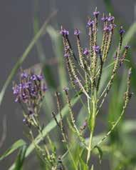
Aronia melanocarpa Black Chokeberry x x Bees, Butterflies Birds Rabbits, Small Mammals
Cephalanthus occidentalis Buttonbush x x Bees, Moths, Butterflies, Wasps Hummingbirds, Waterfowl

Clethra alnifolia Sweet Pepperbush x Bees, Butterflies Hummingbirds Small Mammals
Swida sericea Red-osier Dogwood x
Itea virginica Virginia Sweetspire Butterflies Birds
Lindera benzoin Spicebush x Bees, Flies, Butterflies, Moths Birds Rabbits, Squirrels
Rhus copallinum Winged Sumac Bees Birds Small Mammals
Rosa palustris Swamp Rose Bees Birds
Spiraea tomentosa Steeplebush x Bees, Butterflies Birds
Acer rubrum Red Maple x x Bees Birds nest in it Small Mammals
Amelanchier canadensis
Trees
Serviceberry/ Shadbush x Bees, Butterflies Birds Small Mammals
alleghaniensis Yellow/Swamp Birch x Birds Small Mammals
Betula
Liquidambar styraciflua Sweetgum x Birds Small Mammals
Quercus palustrus Pin Oak x
Butterflies, Moths Birds Turkeys, Deer, Small Mammals
RESILIENCE & RECREATION Conceptual
Designs for D. W. Field Park Brockton, MA | Spring 2023
34 BIORETENTION DESIGNS
PLANTS
Prepared for WILDLANDS TRUST by Audrey Logan & B Ervin
&
Verbena hastata (Blue Vervain) Eutrochium purpereum (Joepye Weed) and swallowtail butterflies
Cephalanthus occidentalis (Buttonbush) Solidago (Goldenrod)
Amelanchier canadensis (Shadbush) and Cedar Waxwing Asters novae-angliae (New England Aster)
TRAFFIC SLOWING TECHNIQUES
Fast moving cars along shared roads create concern for many park-goers, especially those traveling around the parkways with small children. While some people may drive quickly to arrive at a specific destination within the park, others use the park as a cut-through between Brockton and Avon.
What kinds of design elements and planning efforts might help slow down drivers and increase feelings of comfort and safety for people walking and rolling around the park?
NARROW ROADS
According to the Global Street Design Guide, people drive more slowly along narrower roads (Global Designing Cities Initiative). Reducing car lanes from 12 to 11’ maximum width might help slow down drivers within the park.
Considerations: Road width saved from cars could be allocated for separate pedestrian, bike, and shared pathways, as well as green infrastructure facilities like bioswales.
GATEWAY TREATMENTS
Adding features that indicate drivers are entering a space with pedestrians, especially children, might help decrease speed around D.W. Park destinations. These designs could include speed tables, signs, and raised crosswalks.
CHANGES IN ROAD TEXTURES/MATERIALS
Grooves in asphalt, such as rumble strips, can get drivers’ attention. Interrupting a long stretch of pavement with stones, bricks, or a painted pattern can also indicate it’s time for drivers to pay attention.
Considerations: Some surfaces can be more challenging to traverse for bikes, strollers, and wheelchairs.
PROMOTING PUBLIC TRANSPORTATION
Promoting alternative modes of transit could help decrease some of the car traffic within D.W. Field Park. There are currently several bus stops near the Oak Street entrance. Expanding additional lines, or considering setting up shuttle services between an off site parking lot and the park might also help increase transit use.
CAR-FREE HOURS/DAYS
Currently, cars are not able to enter the middle section of the park until 10am during the week and noon on the weekends. Extending these hours, or having a regularly scheduled car-free day on a weekly or monthly basis could be a low cost solution to increasing pedestrian and bicycle use within the park for those who do not wish to share the road.
PARKING LOT PARTNERSHIPS
For large events like Tower Fest, the Park Association arranges overflow parking at a nearby church lot and offers a shuttle. Exploring partnerships with surrounding community organizations and businesses who have parking lots but different peak hours than D.W. Field Park could be a strategy to expand parking capacity for the park without increasing impervious coverage in the area.
SPEED HUMPS AND SPEED TABLES

Speed humps are raised mounds that are generally shorter in height and longer than traditional speed bumps. Cars can drive over these features at a maximum speed of 20mph; the speed limit within D.W. Field Park. Boston recently launched an initiative to add 1,500 speed humps throughout the city by 2026 to reduce traffic-related fatalities. Adding speed humps and speed tables, which are similarly shaped features except with a flat top, throughout the park could help keep drivers at or below the speed limit, particularly around destinations with lots of pedestrian use.
Considerations: The D.W. Park roads are plowed during the winter and plows must be able to pass over these types of features. Additionally, some concerns have been raised about speed increasing between speed humps/tables if not paired with additional slowing measures. An upcoming road conditions and safety study may help investigate and evaluate this risk further.
Reccommended spacing to maintain speeds under 25-35 mph is less than 500’ between speed humps
RESILIENCE & RECREATION Conceptual Designs for D. W.
|
Field Park Brockton, MA
Spring 2023
35 TRAFFIC SLOWING TECHNQIUES
Prepared for WILDLANDS TRUST by Audrey Logan & B Ervin
Masaschusetts Department of Transportation & National Association of City Transportation Officials
Speed Hump 3-4” TALL 12-14’ WIDE
22’ WIDE
MAX SLOPE 1:10
Speed Tables /Raised Pedestrian Cossings
3-3.5” TALL
ENTRANCE ROAD: ALTERNATIVE CONCEPTUAL SECTIONS
This road section is of the road alignment that stretches between the Oak Street Parking Lot and the beginning of the one-way loop along the east side of Upper Porter Pond. It is the only twoway stretch of road in this section of the park.

Existing Conditions
Alternatives
KEY FEATURES
• Entry bike path through woods
• Separate exit bike lane
• Swale separates bike lane from pedestrian path
PROS
• Swale and widened vegetated buffer increase stormwater filtration
• Separate lanes for different users increases safety
CONS
• Pedestrian path is only 5’ wide on this busy stretch
• Bike path through woods will cause some disturbance to forest
KEY FEATURES
• Wide pedestrian path separated from road by swale and shaded by trees
• Cars and cyclists share a 22’ wide road
PROS
• Cars and bikes sharing the road allows space for a wide pedestrian path and swale with minimal disturbance to existing trees


CONS
• Cars and bikes sharing the road may raise safety concerns
Bike Through the Woods
KEY FEATURES
• 7’ boardwalk separates pedestrians from road and offers interesting entry experience
• Separate bike and car lanes
PROS
• Swale and wetland plants increase stormwater filtration
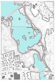
• Separate lanes for different users increases safety
• Minimal disturbance to existing trees
CONS
• Boardwalk is an expensive and complex installation process
Shady Path, Shared Road
Welcome Boardwalk
RESILIENCE & RECREATION Conceptual Designs for D. W. Field Park Brockton, MA | Spring 2023 Prepared for WILDLANDS TRUST by Audrey Logan & B Ervin 36 ENTRANCE ROAD: CONCEPTUAL
SECTIONS
22’ TWO-WAY ROAD SWALE 7’ PATH WIDENED VEGETATED BUFFER 20’ TWO-WAY ROAD SWALE & WETLAND PLANTS 7’ BOARD WALK 5’ BIKE PATH 5’ BIKE PATH 20’ TWO-WAY ROAD 5’ BIKE PATH 5’ PATH 5’ BIKE PATH WIDENED VEGETATED BUFFER
A A’ OAK ST. PARKING LOT ONE- WAY LOOP BEGINS & ENDS 22’ SHARED TWO-WAY ROAD GRASSY SLOPE WITH INFORMAL PATHS
A A’ Oak Street Amphitheater DW d d W WALDO LAKE BROCKTON RESERVOIR UPPER PORTER POND FORESTED SLOPE
VEHICLES PEDESTRIANS 0 20’ 0 20’ 0 20’ 0 20’
NORTHEAST ROAD:
ALTERNATIVE CONCEPTUAL SECTIONS
This road section is of the road alignment that stretches between the Tower Hill Parking Lot and the beginning of the causeway through Waldo Lake. The road is one-way here, and shared between cars, cyclists, and pedestrians. A 6’ paved path runs parallel to the shore here, as well, offering pedestrians an alternative to sharing the road with cars.
Existing Conditions
22’ SHARED ROAD GRASSY SLOPE WITH COMPACTED TURF
Alternatives
Shady Waterfront Promenade
WIDENED VEGETATED BUFFER
KEY FEATURES
11’ ROAD 7’ PATH 5’ BIKE PATH
PROS
• Swale and additional trees separate road from pedestrian path

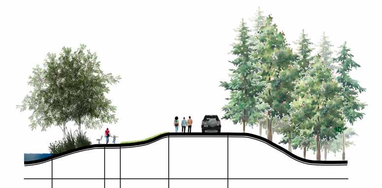


• Separate bike lane
Protect the Shore
5’ SWALE WOODED SLOPE
• Swale and additional trees increase stormwater filtration
• Separate lanes for different users increases safety
CONS
• All pedestrians now use waterfront path, could get crowded
KEY FEATURES
11’ ROAD 6’ SWALE 7’ PATH WIDENED VEGETATED BUFFER
• Wide pedestrian path separated from road by swale
• Delineated bike lane
• Shoreline buffer more than doubled in width
PROS
• Swale increases stormwater infiltration from road
• Large shoreline buffer increases habitat

CONS
• Pedestrians are farther away from water for this stretch and may have less access to water views
RESILIENCE & RECREATION Conceptual Designs for D. W.
|
2023
Field Park Brockton, MA
Spring
37 ENTRANCE ROAD: ALTERNATIVE SECTIONS
Prepared for WILDLANDS TRUST by Audrey Logan & B Ervin
A A’ Oak Street Amphitheater W P k F w W WALDO LAKE BROCKTON RESERVOIR UPPER PORTER POND A A’ TOWER HILL PARKING LOT WALDO LAKE 6’ PAVED PATH VEGETATED SHORELINE
VEHICLES PEDESTRIANS VEGETATED SLOPE
5’ BIKE LANE
5’ BIKE PATH 0 20’ 0 20’ 0 20’
PRELIMINARY COST ESTIMATES: OAK STREET PARKING LOT
RESILIENCE & RECREATION Conceptual Designs for D. W. Field Park
MA | Spring 2023
Brockton,
38
Prepared
for WILDLANDS TRUST by Audrey Logan & B Ervin
PRELIMINARY COST ESTIMATES CATEGORY ITEM AMOUNT/QUANTITY UNIT COST/UNIT (LOW) COST/UNIT (HIGH) TOTAL LOW TOTAL HIGH NOTES Demolition & Site Preparation Asphalt Removal 9648 SF 1.5 2 $14,472.00 $19,296.00 Permeable retrofit Erosion Control/Sediment Fencing 330 LF 1.5 4 $495.00 $1,320.00 Around south and west edges of parking lot Asphalt Paving (Parking Lot Aisles) 3,960 SF 2.5 3 $9,900.00 $11,880.00 Keep existing (if replacing 3,960 sf) Permeable Parking Spaces 11,452 SF 8 15 $91,616.00 $171,780.00 Extruded Curbs 521 LF 20 35 $10,420.00 $18,235.00 Concrete with inlet cuts for bioswales Striping 3,420 LF 0.15 1 $513.00 $3,420.00 Parking space delineation, bike/car lanes, cross walks Permeable Asphalt Paths (5' wide) 2205 SF 7 12 $15,435.00 $26,460.00 Around parking lot and bike rack/kiosk landing Boulder Relocation 9 Each 100 150 $900.00 $1,350.00 Local materials Amenities ABA Paths (5' wide) 4095 SF 3 5 $12,285.00 $20,475.00 Stone Dust Gravel Patio Spaces 2800 SF 3 5 $8,400.00 $14,000.00 Picnic Areas and Exercise Meetup Pad Bridges (wood) 300 SF 40 60 $12,000.00 $18,000.00 Two across wide bioswale Stretching Station 2 Each 950 2200 $1,900.00 $4,400.00 Push-ups and Step-up stations Picnic Tables 6' Long 2 Each 0 0 $0.00 $0.00 Use existing tables Picnic Tables 6' Accesible 2 Each 1200 2200 $2,400.00 $4,400.00 Picnic Tables 6' Round 2 Each 850 2000 $1,700.00 $4,000.00 Benches 5' 10 Each 500 900 $5,000.00 $9,000.00 Bike Rack - Inverted U 5 Each 250 500 $1,250.00 $2,500.00 Porta Potties (standard) 1 Each 50 475 $50.00 $475.00 Monthly rental Porta Potty (ADA accessible) 1 Each 100 700 $100.00 $700.00 Monthly rental Kiosk 1 Each 1500 2000 $1,500.00 $2,000.00 To be designed by Wildlands Trust Interpretive Signs 3 Each 1000 1800 $3,000.00 $5,400.00 Park history by Welcome Center Parking Lot PV's 1 LS 3200 3200 3200 80'x40' SF panels Landscaping Trees (2" caliper) 13 Each 650 800 $8,450.00 $10,400.00 Trees (1" caliper) 2 Each 300 450 $600.00 $900.00 Bioswale Enhancement (parking lot) 291 LF 20 40 $5,820.00 $11,640.00 Possible volunteer Bioswale (road) 130 LF 40 60 $5,200.00 $7,800.00 Includes excavation Rain Gardens 280 SF 20 50 $5,600.00 $14,000.00 Central Island Shrubs/Ground Cover 160 SF 15 25 $2,400.00 $4,000.00 History garden and parking lot island beds Fescue Lawn Mix/Seeding 10000 SF 0.1 0.15 $1,000.00 $1,500.00 Meadow Seed Mix 6500 SF 0.1 0.15 $650.00 $975.00 Community requested 'no-mow' zones and pollinator habitat at this site Vegetated Buffer 380 LF 3 5 $1,140.00 $1,900.00 Along Upper Porter Pond edge, Alternative: Livestaking shrubs could save on cost ($1-2 per LF) Snow Fence (buffer protection) 400 LF 1.5 4 $600.00 $1,600.00 Temporary protection for establishing buffer plantings Low High Estimate Totals $227,396.00 $395,406.00
PRELIMINARY COST ESTIMATES: TOWER HILL PARKING LOT
RESILIENCE & RECREATION Conceptual Designs for D. W. Field Park Brockton, MA | Spring 2023 Prepared for WILDLANDS TRUST by Audrey Logan & B Ervin 39
PRELIMINARY COST ESTIMATES CATEGORY ITEM AMOUNT/QUANTITY UNIT COST/UNIT (LOW) COST/UNIT (HIGH) TOTAL LOW TOTAL HIGH NOTES Demolition & Site Preparation Asphalt Removal 30,000 SF 1.5 2 $45,000.00 $60,000.00 All of current parking lot pavement Excavation/Earth Removal 260 CY 12 15 $3,120.00 $3,900.00 Central island removal and play areas, 1" depth Erosion Control/Sediment Fencing 200 LF 1.5 4 $300.00 $800.00 North side of parking lot Asphalt Paving 4,150 SF 2.5 3.5 $10,375.00 $14,525.00 Parking lot entry/exit and aisle Permeable Parking Spaces 5,400 SF 4 7 $21,600.00 $37,800.00 Porous asphalt Extruded Curbs 260 LF 15 20 $3,900.00 $5,200.00 Concrete Striping 740 LF 0.5 1 $370.00 $740.00 Parking Spaces, Crosswalks 3"-4" Imported Topsoil 100 CY 45 60 $4,500.00 $6,000.00 For lawns Grading 1400 SF 0.1 0.15 $140.00 $210.00 Tilling and grading for lawn, play area, paths Amenities ABA Paths (5' wide) 7925 SF 3 5 $23,775.00 $39,625.00 Stone dust Picnic Areas Landings 600 SF 3 5 $1,800.00 $3,000.00 Crushed stone/gravel Porous Asphalt Paths 1525 SF 7 12 $10,675.00 $18,300.00 Around Parking Lot Natural Play Features (local materials) 1 LS 5,000 8,000 $5,000.00 $8,000.00 Logs, Stumps, Boulders, Mini-Tower construction Mulch (3" depth) 30 CY 40 60 $1,200.00 $1,800.00 3000 SF play area Playscape Edging 400 LF 5 10 $2,000.00 $4,000.00 Plastic or Wood Boardwalk (wood, 5' wide) 800 SF 40 60 $32,000.00 $48,000.00 Picnic Tables (6' long) 1 Each 800 1800 $800.00 $1,800.00 3 existing, 1 new Picnic Tables 6' Accesible 2 Each 1200 2200 $2,400.00 $4,400.00 Benches 5' 6 Each 500 900 $3,000.00 $5,400.00 Storage Shed 1 Each 1000 2500 $1,000.00 $2,500.00 Partitioned, 8x12' Bike Rack - Inverted U 5 Each 250 500 $1,250.00 $2,500.00 Porta Potties (standard) 1 Each 50 475 $50.00 $475.00 Monthly Rental Porta Potty (ADA accessible) 1 Each 100 700 $100.00 $700.00 Monthly Rental Trail Placard Post 2 Each 150 350 $300.00 $700.00 By nature trailheads Interpretive Sign 1 Each 1000 1800 $1,000.00 $1,800.00 Nature walk (woodland ecology/bird identification) Landscaping Trees (2" caliper) 11 Each 650 800 $7,150.00 $8,800.00 Trees (1" caliper) 3 Each 300 450 $900.00 $1,350.00 Bioswale (parking lot) 150 LF 20 40 $3,000.00 $6,000.00 Possible volunteer support Rain Gardens 120 LF 20 60 $2,400.00 $7,200.00 Possible volunteer support Fescue Lawn Mix/Seeding 8860 SF 0.1 0.15 $886.00 $1,329.00 Boulder Relocation 6 Each 100 150 $600.00 $900.00 Live Stake Hedge (dogwood/elderberry) 600 Each 1 2 $600.00 $1,200.00 along north edge of parking lot (1 stake per 1 SF) Low High Estimate Totals $190,591.00 $297,754.00
WORKS CITED
Works Cited
“About the Gateway C ties ” MassINC massinc org/our-work/pol cy-center/gateway-cities/about-the-gateway-cities/.
Bingham Kenneth E, et al Daniel Wa do Fie d and D W Fie d Park : A History Createspace Independent Publishing 2014
City of Brockton Open Space and Recreation Plan. Nov. 2022
Detro ters Working for Environmental Justice “Detroiters Working for Environmental Justice | Protecting Detroiters’ Right to Clean Air Safe Water and Healthy Neighborhoods.” Detroiters Work ng for Environmenta Justice - about Us detroitenvironmentaljustice.org/
Manomet D W Fie d Park Habitat Assessment and Natural Resource Inventory 31 Mar 2023
Massachusett Tr be. “Our History – the Massachusett Tribe at Ponkapoag ” The Massachusett Tribe at Ponkapoag massachusetttribe org/our-history Accessed 23 June 2023
National Environmental Education Foundation (NEEF) “The National Environmental Education Foundation | NEEF” Neefusa.org neefusa.org/ Accessed 23 June 2023
Park, DW Field “D W Field Park ” D W Field Park, dwfieldpark info/ Accessed 23 June 2023
The Black Institute “ Who We Are – the Black Institute ” Theblack nst tute org, 2023, theblackinstitute.org/who-we-are/ Accessed 23 June 2023
Town of Ipswich Recommended Buffer Zone P antings Species Native to Eastern Massachusetts

US EPA. “Urban Runoff: Low Impact Development | US EPA.” US EPA, 6 Aug. 2018, www epa.gov/nps/urban-runoff-low-impact-development.
USDA “Official Series Description - NEWFIELDS Series ” Soilseries sc egov usda gov, soilseries.sc.egov.usda gov/OSD Docs/N/NEWFIELDS html# ~:text=The%20Newfields%20series%
20consists%20of Accessed 23 June 2023
USDA “Official Series Description - NORWELL Series ” So lseries sc egov usda gov, soilseries.sc.egov.usda gov/OSD Docs/N/NORWELL .html Accessed 23 June 2023.
USDA “Official Series Description - WHITMAN Series ” Soilser es sc egov usda gov soilseries sc egov usda gov/OSD Docs/W/WHITMAN html Accessed 23 June 2023
USDA Forest Service Accessib lity Guidebook for Outdoor Recreation and Trai s. Aug. 2012.
“ Visitor Info | Passanageset ” Passanageset passanageset org/passanageset-park-at-broad-meadows-marsh/v sitor-info/ Accessed 23 June 2023.
Winchester Conservation Commission “Native and Wetland Plants ” Town of W nchester Conservat on Commission 9 Apr. 2022, www.winchester.us/DocumentCenter/V ew/7979/Wetland-Plant-List
RESILIENCE & RECREATION Conceptual Designs for D. W. Field Park Brockton, MA | Spring 2023 Prepared for WILDLANDS TRUST by Audrey Logan & B Ervin 40 WORKS CITED

